Bridge Statistics for Mountain Home, Arkansas (AR)
Condition, Traffic, Stress, Structural Evaluation, Project Costs
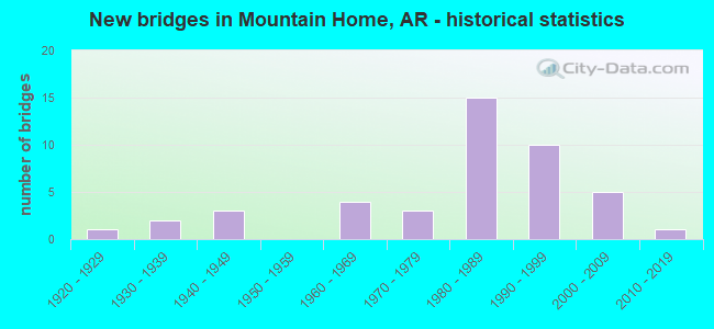
- New bridges - historical statistics
- 11920-1929
- 21930-1939
- 31940-1949
- 41960-1969
- 31970-1979
- 151980-1989
- 101990-1999
- 52000-2009
- 12010-2019
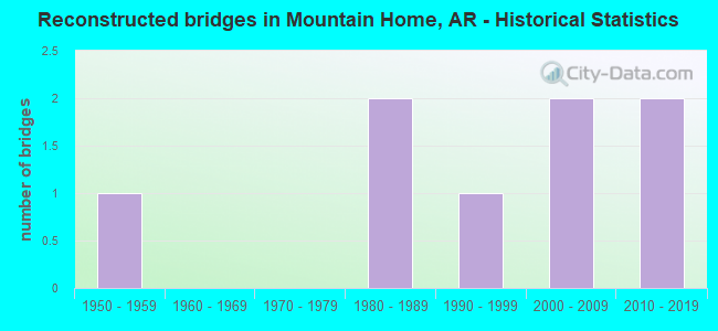
- Reconstructed bridges - Historical Statistics
- 11950-1959
- 01960-1969
- 01970-1979
- 21980-1989
- 11990-1999
- 22000-2009
- 22010-2019
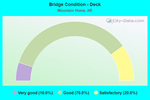
- Bridge Condition - Deck
- 10.0%Very good
- 70.0%Good
- 20.0%Satisfactory
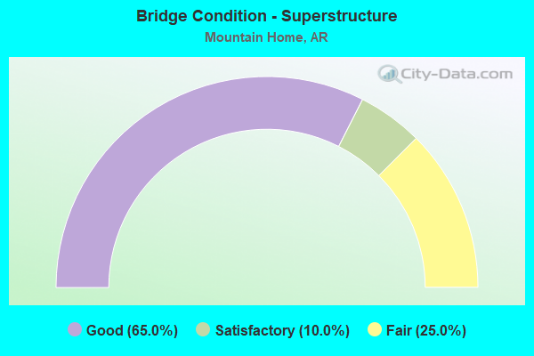
- Bridge Condition - Superstructure
- 65.0%Good
- 10.0%Satisfactory
- 25.0%Fair
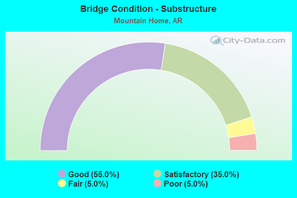
- Bridge Condition - Substructure
- 55.0%Good
- 35.0%Satisfactory
- 5.0%Fair
- 5.0%Poor
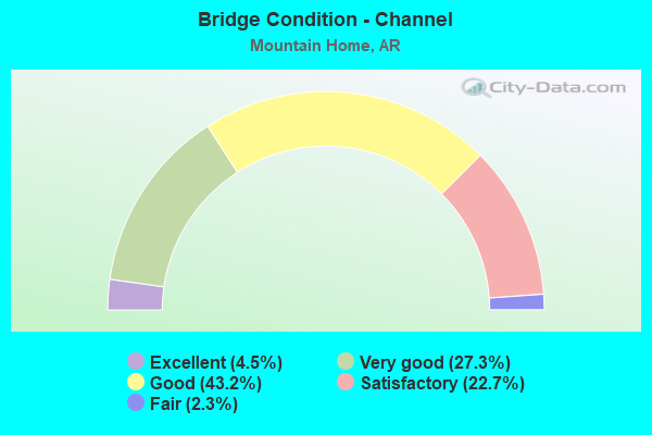
- Bridge Condition - Channel
- 4.5%Excellent
- 27.3%Very good
- 43.2%Good
- 22.7%Satisfactory
- 2.3%Fair
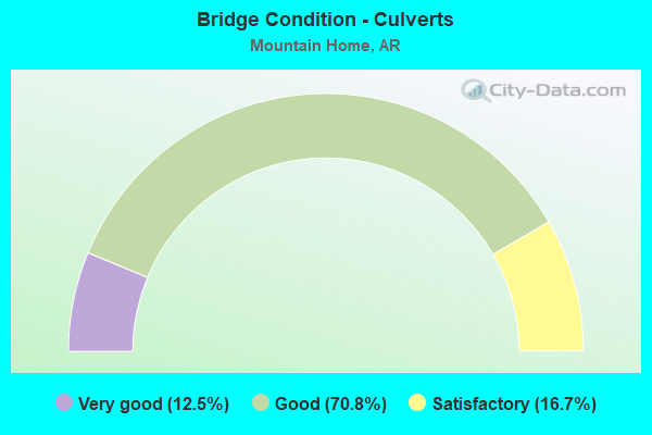
- Bridge Condition - Culverts
- 12.5%Very good
- 70.8%Good
- 16.7%Satisfactory
Find on map >> Show street view
Structure Number: AHTD000000M3875, Location: 13 MI SE of Mountain Home (Lat: 36.248333, Lng: -92.237778), Route carried "on" structure: State highway 177, Year Built: 1944, Year Reconstructed: 2008, Status: Open, Structure Length: 17.55m (57.58ft), Average Daily Traffic: 2,800 (year 2020), Truck Traffic: 5%, Average Future Daily Traffic: 2,860 (year 2039), Design Load: HS 20, Features Intersected: Norfork Dam Spillway
Minimum Vertical Clearance: 30+ m (98+ ft), Kilometerpoint: 0.000, Lanes on structure: 2, Owner: Corps of Engineers (Civil), Approaching Roadway Width: 7.0m (23.0ft), Skew: 10 degrees, Material/Design: Concrete, Design/Construction: Slab, Number Of Spans In Main Unit: 12, Length of Maximum Span: 14.5m (47.6ft), Curb or Sidewalk Widths: Left: 1.2m (3.9ft), Right: 0.6m (2.0ft), Curb-To-Curb Width: 7.8m (25.6ft), Out-to-Out Width: 12.8m (42.0ft)
Condition: Deck: Satisfactory, Superstructure: Satisfactory, Substructure: Satisfactory, Channel: Excellent, Operating Rating: 44.7 metric tons, Method Used To Determine Operating Rating: Load and Resistance Factor Rating (LRFR) rating reported by rating factor(RF) method using HL-93 loadings, Inventory Rating: 34.7 metric tons, Method Used To Determine Inventory Rating: Load and Resistance Factor Rating (LRFR) rating reported by rating factor(RF) method using HL-93 loadings, Structural Evaluation: Equal to present minimum criteria, Deck Geometry: High priority of replacement, Waterway Adequacy: Superior to present desirable criteria, Approach Roadway Alignment: Equal to present desirable criteria, Length Of Structure Improvement: 17.55m (57.58ft), Designated Inspection Frequency: Every 24 months, Inspection Date: October 2021, Bridge Improvement Cost: $750,000, Roadway Improvement Cost: $75,000, Total Project Cost: $825,000 ( Estimate for 2015), Deck Structure Type: Concrete Cast-file-Place, Wearing Surface/Protective System: Wearing Surface: Latex Concrete
Find on map >> Show street view
Structure Number: 593, Location: 1.55 MI E OF JCT US 62 B (Lat: 36.327231, Lng: -92.354461), Route carried "under" structure: US 62, Structure Length: 0. m, Average Daily Traffic: 4,100 (year 2014), Truck Traffic: 1%, Features Intersected: US 62, Facility Carried by Structure: SH 5 Baxter
Minimum Vertical Clearance: 4.93m (16.17ft), Kilometerpoint: 17.333, Length of Maximum Span: 0.0m
Find on map >> Show street view
Structure Number: 593, Location: 1.55 MI E OF JCT US 62 B (Lat: 36.327231, Lng: -92.354461), Route carried "under" structure: US 62, Structure Length: 0. m, Average Daily Traffic: 4,100 (year 2014), Truck Traffic: 1%, Features Intersected: US 62, Facility Carried by Structure: SH 5 Baxter
Minimum Vertical Clearance: 5.46m (17.91ft), Kilometerpoint: 17.333, Length of Maximum Span: 0.0m