Bridge Statistics for Mountain Top, Pennsylvania (PA)
Condition, Traffic, Stress, Structural Evaluation, Project Costs
- National Bridge Inventory (NBI) Statistics
- 46Number of bridges
- 259ft / 78.5mTotal length
- $5,982,000Total costs
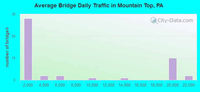
- 286,006Total average daily traffic
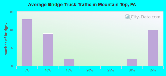
- 75,489Total average daily truck traffic
- National Bridge Inventory (NBI) Registered Bridges for Mountain Top
- No street view available for this location
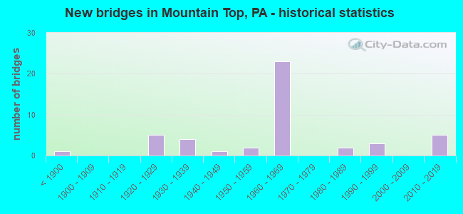
- New bridges - historical statistics
- 1Before 1900
- 51920-1929
- 41930-1939
- 11940-1949
- 21950-1959
- 231960-1969
- 21980-1989
- 31990-1999
- 52010-2019
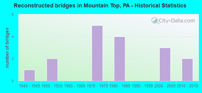
- Reconstructed bridges - Historical Statistics
- 11940-1949
- 21950-1959
- 01960-1969
- 51970-1979
- 41980-1989
- 01990-1999
- 32000-2009
- 22010-2019
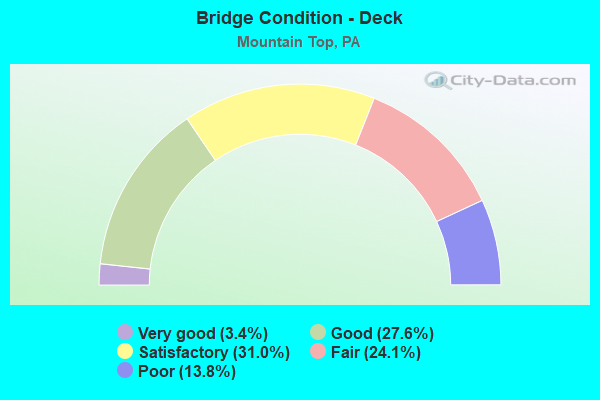
- Bridge Condition - Deck
- 3.4%Very good
- 27.6%Good
- 31.0%Satisfactory
- 24.1%Fair
- 13.8%Poor

- Bridge Condition - Superstructure
- 3.3%Excellent
- 10.0%Very good
- 20.0%Good
- 16.7%Satisfactory
- 36.7%Fair
- 10.0%Poor
- 3.3%Serious
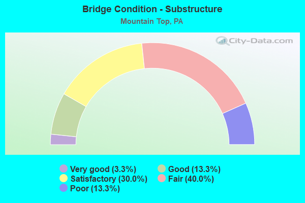
- Bridge Condition - Substructure
- 3.3%Very good
- 13.3%Good
- 30.0%Satisfactory
- 40.0%Fair
- 13.3%Poor
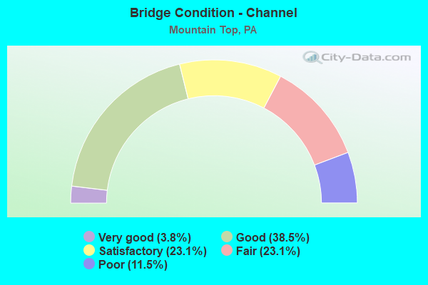
- Bridge Condition - Channel
- 3.8%Very good
- 38.5%Good
- 23.1%Satisfactory
- 23.1%Fair
- 11.5%Poor
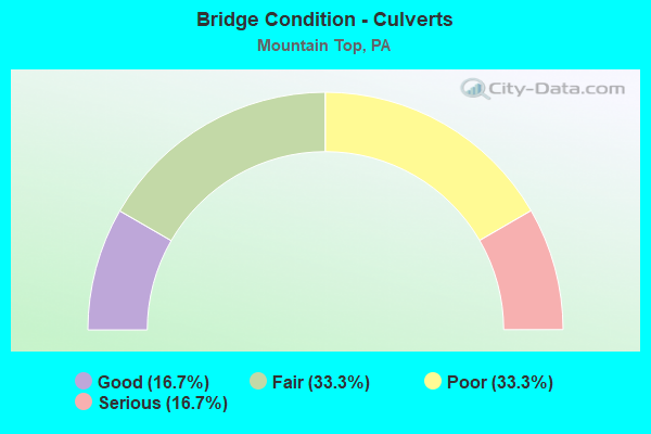
- Bridge Condition - Culverts
- 16.7%Good
- 33.3%Fair
- 33.3%Poor
- 16.7%Serious
Find on map >> Show street view
Structure Number: 23716, Location: RICE TWP 2 M S SR 2042 (Lat: 41.121442, Lng: -75.962144), Route carried "under" structure: Interstate 81, Year Built: 1965, Structure Length: 0. m, Average Daily Traffic: 19,175 (year 2021), Truck Traffic: 32%, Features Intersected: SR 0081 I-81 NB, Facility Carried by Structure: SR 3102 TWP RD 399
Minimum Vertical Clearance: 5.16m (16.93ft), Kilometerpoint: 27.850, Lanes on structure: 2, Lanes under structure: 2, Material/Design: Prestressed concrete, Design/Construction: Box Beam or Girders - Single/Spread, Length of Maximum Span: 19.8m (65.0ft)
Find on map >> Show street view
Structure Number: 23717, Location: RICE TWP 2 M S SR 2042 (Lat: 41.121775, Lng: -75.961508), Route carried "under" structure: Interstate 81, Year Built: 1965, Structure Length: 0. m, Average Daily Traffic: 18,874 (year 2021), Truck Traffic: 32%, Features Intersected: SR 0081 I-81 SB, Facility Carried by Structure: SR 3102 TWP RD 399
Minimum Vertical Clearance: 5.16m (16.93ft), Kilometerpoint: 27.809, Lanes on structure: 2, Lanes under structure: 2, Material/Design: Prestressed concrete, Design/Construction: Box Beam or Girders - Single/Spread, Length of Maximum Span: 20.1m (65.9ft)
Find on map >> Show street view
Structure Number: 2372, Location: RICE TWP 1 M S SR 2042 (Lat: 41.133639, Lng: -75.962328), Route carried "under" structure: County highway , Year Built: 1964, Structure Length: 0. m, Average Daily Traffic: 200 (year 1992), Truck Traffic: 1%, Features Intersected: BLYTHEBURN ROAD, Facility Carried by Structure: I-81 NB
Minimum Vertical Clearance: 4.36m (14.30ft), Kilometerpoint: 0.000, Lanes on structure: 2, Lanes under structure: 2, Material/Design: Prestressed concrete, Design/Construction: Box Beam or Girders - Single/Spread, Length of Maximum Span: 11.0m (36.1ft)
Find on map >> Show street view
Structure Number: 23722, Location: RICE TWP 1 M S SR 2042 (Lat: 41.134256, Lng: -75.963206), Route carried "under" structure: County highway , Year Built: 1965, Structure Length: 0. m, Average Daily Traffic: 200 (year 1992), Features Intersected: BLYTHEBURN ROAD, Facility Carried by Structure: SR 0081 I-81 SB
Minimum Vertical Clearance: 4.48m (14.70ft), Kilometerpoint: 0.000, Lanes on structure: 3, Lanes under structure: 2, Material/Design: Prestressed concrete, Design/Construction: Box Beam or Girders - Single/Spread, Length of Maximum Span: 13.1m (43.0ft)
Find on map >> Show street view
Structure Number: 24146, Location: RICE TWP OVER I-81 SB (Lat: 41.146906, Lng: -75.963694), Route carried "under" structure: Interstate 81, Year Built: 1964, Structure Length: 0. m, Average Daily Traffic: 21,315 (year 2021), Truck Traffic: 28%, Features Intersected: SR 0081 I-81 SB EXIT 159, Facility Carried by Structure: SR 2042
Minimum Vertical Clearance: 5.15m (16.90ft), Kilometerpoint: 31.023, Lanes on structure: 2, Lanes under structure: 2, Material/Design: Prestressed concrete, Design/Construction: Box Beam or Girders - Single/Spread, Length of Maximum Span: 17.7m (58.1ft)
Find on map >> Show street view
Structure Number: 24147, Location: RICE TWP OVER I-81 NB (Lat: 41.146964, Lng: -75.962517), Route carried "under" structure: Interstate 81, Year Built: 1964, Structure Length: 0. m, Average Daily Traffic: 21,036 (year 2021), Truck Traffic: 28%, Features Intersected: SR 0081 I-81 NB EXIT 159, Facility Carried by Structure: SR 2042
Minimum Vertical Clearance: 5.12m (16.80ft), Kilometerpoint: 31.059, Lanes on structure: 2, Lanes under structure: 2, Material/Design: Prestressed concrete, Design/Construction: Box Beam or Girders - Single/Spread, Length of Maximum Span: 18.3m (60.0ft)