Bridge Statistics for Mulvane, Kansas (KS)
Condition, Traffic, Stress, Structural Evaluation, Project Costs
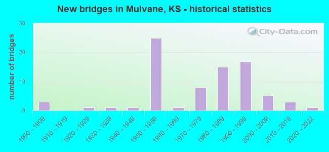
- New bridges - historical statistics
- 31900-1909
- 11920-1929
- 11930-1939
- 11940-1949
- 251950-1959
- 11960-1969
- 81970-1979
- 151980-1989
- 171990-1999
- 52000-2009
- 32010-2019
- 12020-2022
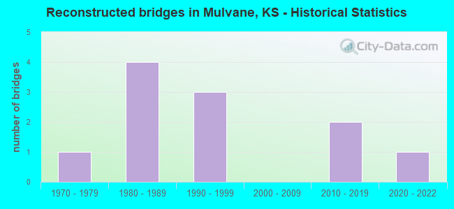
- Reconstructed bridges - Historical Statistics
- 11970-1979
- 41980-1989
- 31990-1999
- 02000-2009
- 22010-2019
- 12020-2022
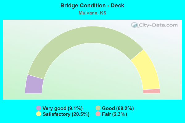
- Bridge Condition - Deck
- 9.1%Very good
- 68.2%Good
- 20.5%Satisfactory
- 2.3%Fair
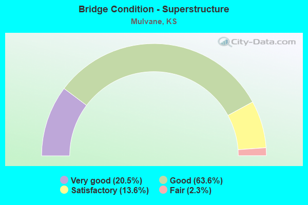
- Bridge Condition - Superstructure
- 20.5%Very good
- 63.6%Good
- 13.6%Satisfactory
- 2.3%Fair
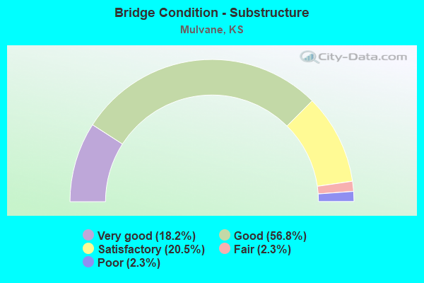
- Bridge Condition - Substructure
- 18.2%Very good
- 56.8%Good
- 20.5%Satisfactory
- 2.3%Fair
- 2.3%Poor
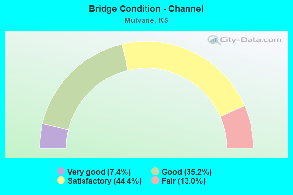
- Bridge Condition - Channel
- 7.4%Very good
- 35.2%Good
- 44.4%Satisfactory
- 13.0%Fair
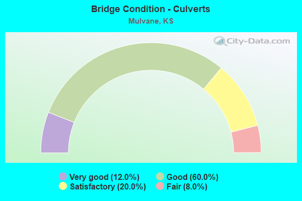
- Bridge Condition - Culverts
- 12.0%Very good
- 60.0%Good
- 20.0%Satisfactory
- 8.0%Fair
Find on map >> Show street view
Structure Number: 999901500874351, Location: 1.40 MI N SUMNER COLN (Lat: 37.489444, Lng: -97.247222), Route carried "on" structure: State highway 15, Year Built: 1996, Status: Open, Structure Length: 4.34m (14.24ft), Average Daily Traffic: 4,014 (year 2020), Truck Traffic: 6%, Average Future Daily Traffic: 4,707 (year 2041), Design Load: HS 25 or greater, Features Intersected: BNSF RAILWAY
Minimum Vertical Clearance: 30.47m (99.97ft), Kilometerpoint: 2.255, Lanes on structure: 2, Base Highway Network: Yes, Owner: State Highway Agency, Approaching Roadway Width: 28.0m (91.9ft), Skew: 20 degrees, Material/Design: Concrete continuous, Design/Construction: Slab, Number Of Spans In Main Unit: 3, Length of Maximum Span: 17.1m (56.1ft), Curb or Sidewalk Widths: Left: 0.0m, Right: 1.5m (4.9ft), Curb-To-Curb Width: 10.7m (35.1ft), Out-to-Out Width: 13.5m (44.3ft)
Condition: Deck: Good, Superstructure: Good, Substructure: Very good, Operating Rating: 89.8 metric tons, Method Used To Determine Operating Rating: Load Factor (LF), Inventory Rating: 54.4 metric tons, Method Used To Determine Inventory Rating: Load Factor (LF), Structural Evaluation: Better than present minimum criteria, Deck Geometry: Somewhat better than minimum adequacy, Underclear: Superior to present desirable criteria, Approach Roadway Alignment: Equal to present desirable criteria, Length Of Structure Improvement: 14.25m (46.75ft), Designated Inspection Frequency: Every 24 months, Inspection Date: September 2020, Wearing Surface/Protective System: Wearing Surface: Monolithic Concrete, Deck Protection: Epoxy Coated Reinforcing
Find on map >> Show street view
Structure Number: 999901500874361, Location: 1.40 MI N SUMNER COLN (Lat: 37.489444, Lng: -97.247500), Route carried "on" structure: State highway 15, Year Built: 1998, Status: Open, Structure Length: 4.34m (14.24ft), Average Daily Traffic: 4,014 (year 2020), Truck Traffic: 6%, Average Future Daily Traffic: 4,707 (year 2041), Design Load: HS 25 or greater, Features Intersected: BNSF RAILWAY
Minimum Vertical Clearance: 30.47m (99.97ft), Kilometerpoint: 2.243, Lanes on structure: 2, Base Highway Network: Yes, Owner: State Highway Agency, Approaching Roadway Width: 27.6m (90.6ft), Skew: 20 degrees, Material/Design: Concrete continuous, Design/Construction: Slab, Number Of Spans In Main Unit: 3, Length of Maximum Span: 17.1m (56.1ft), Curb-To-Curb Width: 13.5m (44.3ft), Out-to-Out Width: 13.8m (45.3ft)
Condition: Deck: Good, Superstructure: Good, Substructure: Very good, Operating Rating: 89.8 metric tons, Method Used To Determine Operating Rating: Load Factor (LF), Inventory Rating: 54.4 metric tons, Method Used To Determine Inventory Rating: Load Factor (LF), Structural Evaluation: Better than present minimum criteria, Deck Geometry: Superior to present desirable criteria, Underclear: Superior to present desirable criteria, Approach Roadway Alignment: Equal to present desirable criteria, Length Of Structure Improvement: 14.25m (46.75ft), Designated Inspection Frequency: Every 24 months, Inspection Date: September 2020, Wearing Surface/Protective System: Wearing Surface: Monolithic Concrete, Deck Protection: Epoxy Coated Reinforcing
Find on map >> Show street view
Structure Number: 999901500874561, Location: 1.81 MI N SUMNER COLN (Lat: 37.494167, Lng: -97.252222), Route carried "on" structure: State highway 15, Year Built: 1998, Status: Open, Structure Length: 0.67m (2.20ft), Average Daily Traffic: 4,014 (year 2020), Truck Traffic: 6%, Average Future Daily Traffic: 4,707 (year 2041), Design Load: HS 20, Features Intersected: ARKANSAS RIVER DRAINAGE
Minimum Vertical Clearance: 30.47m (99.97ft), Kilometerpoint: 2.918, Lanes on structure: 6, Base Highway Network: Yes, Owner: State Highway Agency, Approaching Roadway Width: 27.4m (89.9ft), Skew: 20 degrees, Material/Design: Concrete, Design/Construction: Culvert, Number Of Spans In Main Unit: 2, Length of Maximum Span: 3.0m (9.8ft), Curb-To-Curb Width: 34.9m (114.5ft), Out-to-Out Width: 62.2m (204.1ft)
Condition: Channel: Good, Culverts: Good, Inventory Rating: 10.8 metric tons, Method Used To Determine Inventory Rating: Load Factor (LF), Structural Evaluation: High priority of corrective action, Deck Geometry: Superior to present desirable criteria, Waterway Adequacy: Equal to present desirable criteria, Approach Roadway Alignment: Equal to present desirable criteria, Length Of Structure Improvement: 2.20m (7.22ft), Designated Inspection Frequency: Every 24 months, Inspection Date: September 2020, Deck Structure Type: Concrete Cast-file-Place, Wearing Surface/Protective System: Wearing Surface: Monolithic Concrete
Find on map >> Show street view
Structure Number: 999901500960861, Location: 4.15 MI NW COWLEY COLN (Lat: 37.461389, Lng: -97.209444), Route carried "on" structure: State highway 15, Year Built: 1945, Year Reconstructed: 1980, Status: Open, Structure Length: 0.63m (2.07ft), Average Daily Traffic: 6,649 (year 2020), Truck Traffic: 5%, Average Future Daily Traffic: 7,202 (year 2041), Design Load: H 20, Features Intersected: TURNER CREEK
Minimum Vertical Clearance: 30.47m (99.97ft), Kilometerpoint: 6.655, Lanes on structure: 2, Base Highway Network: Yes, Owner: State Highway Agency, Approaching Roadway Width: 12.2m (40.0ft), Material/Design: Concrete, Design/Construction: Culvert, Number Of Spans In Main Unit: 2, Length of Maximum Span: 3.0m (9.8ft), Curb-To-Curb Width: 13.4m (44.0ft), Out-to-Out Width: 14.0m (45.9ft)
Condition: Channel: Good, Culverts: Good, Operating Rating: 32.2 metric tons, Method Used To Determine Operating Rating: Load Factor (LF), Inventory Rating: 19.3 metric tons, Method Used To Determine Inventory Rating: Load Factor (LF), Structural Evaluation: Meets minimum limits, Deck Geometry: Equal to present minimum criteria, Waterway Adequacy: Better than present minimum criteria, Approach Roadway Alignment: Somewhat better than minimum adequacy, Length Of Structure Improvement: 2.08m (6.82ft), Designated Inspection Frequency: Every 24 months, Inspection Date: October 2021, Deck Structure Type: Concrete Cast-file-Place, Wearing Surface/Protective System: Wearing Surface: Bituminous
Find on map >> Show street view
Structure Number: 999901500961301, Location: 2.51 MI NW COWLEY COLN (Lat: 37.445833, Lng: -97.187222), Route carried "on" structure: State highway 15, Year Built: 1980, Status: Open, Structure Length: 3.12m (10.24ft), Average Daily Traffic: 6,649 (year 2020), Truck Traffic: 5%, Average Future Daily Traffic: 7,202 (year 2041), Design Load: HS 20, Features Intersected: BITTER CREEK
Minimum Vertical Clearance: 30.47m (99.97ft), Kilometerpoint: 4.033, Lanes on structure: 2, Base Highway Network: Yes, Owner: State Highway Agency, Approaching Roadway Width: 12.2m (40.0ft), Material/Design: Concrete continuous, Design/Construction: Slab, Number Of Spans In Main Unit: 3, Length of Maximum Span: 12.2m (40.0ft), Curb-To-Curb Width: 12.2m (40.0ft), Out-to-Out Width: 12.8m (42.0ft)
Condition: Deck: Good, Superstructure: Good, Substructure: Good, Channel: Good, Operating Rating: 62.6 metric tons, Method Used To Determine Operating Rating: Load Factor (LF), Inventory Rating: 37.2 metric tons, Method Used To Determine Inventory Rating: Load Factor (LF), Structural Evaluation: Better than present minimum criteria, Deck Geometry: Somewhat better than minimum adequacy, Waterway Adequacy: Better than present minimum criteria, Approach Roadway Alignment: Equal to present desirable criteria, Length Of Structure Improvement: 10.25m (33.63ft), Designated Inspection Frequency: Every 24 months, Inspection Date: October 2021, Deck Structure Type: Concrete Cast-file-Place, Wearing Surface/Protective System: Wearing Surface: Low Slump Concrete
Find on map >> Show street view
Structure Number: 999901500961311, Location: 5.16 MI NW COWLEY COLN (Lat: 37.471111, Lng: -97.223333), Route carried "on" structure: State highway 15, Year Built: 1980, Status: Open, Structure Length: 5.20m (17.06ft), Average Daily Traffic: 6,649 (year 2020), Truck Traffic: 5%, Average Future Daily Traffic: 7,202 (year 2041), Design Load: HS 20, Features Intersected: DOG CREEK
Minimum Vertical Clearance: 30.47m (99.97ft), Kilometerpoint: 8.298, Lanes on structure: 2, Base Highway Network: Yes, Owner: State Highway Agency, Approaching Roadway Width: 12.2m (40.0ft), Material/Design: Concrete continuous, Design/Construction: Slab, Number Of Spans In Main Unit: 4, Length of Maximum Span: 14.6m (47.9ft), Curb-To-Curb Width: 12.2m (40.0ft), Out-to-Out Width: 12.8m (42.0ft)
Condition: Deck: Good, Superstructure: Good, Substructure: Good, Channel: Good, Operating Rating: 62.6 metric tons, Method Used To Determine Operating Rating: Load Factor (LF), Inventory Rating: 38.1 metric tons, Method Used To Determine Inventory Rating: Load Factor (LF), Structural Evaluation: Better than present minimum criteria, Deck Geometry: Somewhat better than minimum adequacy, Waterway Adequacy: Equal to present desirable criteria, Approach Roadway Alignment: Somewhat better than minimum adequacy, Length Of Structure Improvement: 17.05m (55.94ft), Designated Inspection Frequency: Every 24 months, Inspection Date: October 2021, Deck Structure Type: Concrete Cast-file-Place, Wearing Surface/Protective System: Wearing Surface: Epoxy Overlay
Find on map >> Show street view
Structure Number: 999901500961411, Location: 5.51 MI NW COWLEY COLN (Lat: 37.474444, Lng: -97.228056), Route carried "on" structure: State highway 15, Year Built: 1996, Status: Open, Structure Length: 6.53m (21.42ft), Average Daily Traffic: 3,570 (year 2020), Truck Traffic: 7%, Average Future Daily Traffic: 4,187 (year 2041), Design Load: HS 25 or greater, Features Intersected: K-53 HWY
Minimum Vertical Clearance: 30.47m (99.97ft), Kilometerpoint: 8.867, Lanes on structure: 4, Lanes under structure: 2, Base Highway Network: Yes, Owner: State Highway Agency, Approaching Roadway Width: 27.4m (89.9ft), Skew: 24 degrees, Material/Design: Steel continuous, Design/Construction: Stringer/Multi-beam, Number Of Spans In Main Unit: 3, Length of Maximum Span: 25.3m (83.0ft), Curb-To-Curb Width: 26.5m (86.9ft), Out-to-Out Width: 27.1m (88.9ft)
Condition: Deck: Good, Superstructure: Very good, Substructure: Good, Operating Rating: 55.4 metric tons, Method Used To Determine Operating Rating: Load Factor (LF), Inventory Rating: 33.2 metric tons, Method Used To Determine Inventory Rating: Load Factor (LF), Structural Evaluation: Better than present minimum criteria, Deck Geometry: Superior to present desirable criteria, Underclear: Superior to present desirable criteria, Approach Roadway Alignment: Equal to present desirable criteria, Length Of Structure Improvement: 21.44m (70.34ft), Designated Inspection Frequency: Every 24 months, Inspection Date: October 2021, Wearing Surface/Protective System: Wearing Surface: Low Slump Concrete, Deck Protection: Epoxy Coated Reinforcing
Find on map >> Show street view
Structure Number: 999903500872193, Location: 1.04 MI N SUMNER CO LINE (Lat: 37.491667, Lng: -97.323611), Route carried "on" structure: ServiceCounty highway 28, Year Built: 1956, Year Reconstructed: 2019, Status: Open, Structure Length: 4.98m (16.34ft), Average Daily Traffic: 99 (year 2020), Average Future Daily Traffic: 19,986 (year 2041), Design Load: HS 20, Features Intersected: I-35 HWY (KTA), Facility Carried by Structure: 111 TH
Minimum Vertical Clearance: 30.47m (99.97ft), Kilometerpoint: 5.076, Lanes on structure: 2, Lanes under structure: 4, Owner: State Toll Authority, Approaching Roadway Width: 7.9m (25.9ft), Material/Design: Steel continuous, Design/Construction: Stringer/Multi-beam, Number Of Spans In Main Unit: 4, Length of Maximum Span: 14.0m (45.9ft), Curb-To-Curb Width: 7.9m (25.9ft), Out-to-Out Width: 9.5m (31.2ft)
Condition: Deck: Good, Superstructure: Good, Substructure: Good, Operating Rating: 51.1 metric tons, Method Used To Determine Operating Rating: Load Factor (LF), Inventory Rating: 30.7 metric tons, Method Used To Determine Inventory Rating: Load Factor (LF), Structural Evaluation: Better than present minimum criteria, Deck Geometry: Equal to present minimum criteria, Underclear: Meets minimum limits, Approach Roadway Alignment: Somewhat better than minimum adequacy, Length Of Structure Improvement: 16.35m (53.64ft), Designated Inspection Frequency: Every 24 months, Inspection Date: July 2021, Deck Structure Type: Concrete Cast-file-Place, Wearing Surface/Protective System: Wearing Surface: Monolithic Concrete
Find on map >> Show street view
Structure Number: 999903500872203, Location: 1.22 MI N SUMNER CO LINE (Lat: 37.494167, Lng: -97.323611), Route carried "on" structure: Interstate 35, Year Built: 1956, Status: Open, Structure Length: 4.22m (13.85ft), Average Daily Traffic: 11,350 (year 2020), Truck Traffic: 24%, Average Future Daily Traffic: 16,866 (year 2041), Design Load: HS 20+Mod, Features Intersected: COWSKIN CREEK
Minimum Vertical Clearance: 30.47m (99.97ft), Kilometerpoint: 1.952, Lanes on structure: 2, Base Highway Network: Yes, Toll: On Interstate toll segment, Owner: State Toll Authority, Approaching Roadway Width: 11.0m (36.1ft), Material/Design: Steel continuous, Design/Construction: Stringer/Multi-beam, Number Of Spans In Main Unit: 3, Length of Maximum Span: 15.2m (49.9ft), Curb-To-Curb Width: 9.8m (32.2ft), Out-to-Out Width: 10.5m (34.4ft)
Condition: Deck: Satisfactory, Superstructure: Good, Substructure: Good, Channel: Good, Operating Rating: 56.2 metric tons, Method Used To Determine Operating Rating: Load Factor (LF), Inventory Rating: 33.7 metric tons, Method Used To Determine Inventory Rating: Load Factor (LF), Structural Evaluation: Better than present minimum criteria, Deck Geometry: High priority of replacement, Waterway Adequacy: Better than present minimum criteria, Approach Roadway Alignment: Equal to present minimum criteria, Length Of Structure Improvement: 13.85m (45.44ft), Designated Inspection Frequency: Every 24 months, Inspection Date: July 2021, Deck Structure Type: Concrete Cast-file-Place, Wearing Surface/Protective System: Wearing Surface: Epoxy Overlay
Find on map >> Show street view
Structure Number: 999903500872213, Location: 1.21 MI N SUMNER CO LINE (Lat: 37.494167, Lng: -97.323611), Route carried "on" structure: Interstate 35, Year Built: 1956, Status: Open, Structure Length: 4.22m (13.85ft), Average Daily Traffic: 11,350 (year 2020), Truck Traffic: 24%, Average Future Daily Traffic: 16,866 (year 2041), Design Load: HS 20+Mod, Features Intersected: COWSKIN CREEK
Minimum Vertical Clearance: 30.47m (99.97ft), Kilometerpoint: 1.954, Lanes on structure: 2, Base Highway Network: Yes, Toll: On Interstate toll segment, Owner: State Toll Authority, Approaching Roadway Width: 11.0m (36.1ft), Material/Design: Steel continuous, Design/Construction: Stringer/Multi-beam, Number Of Spans In Main Unit: 3, Length of Maximum Span: 15.2m (49.9ft), Curb-To-Curb Width: 9.8m (32.2ft), Out-to-Out Width: 10.5m (34.4ft)
Condition: Deck: Satisfactory, Superstructure: Good, Substructure: Good, Channel: Good, Operating Rating: 56.2 metric tons, Method Used To Determine Operating Rating: Load Factor (LF), Inventory Rating: 33.7 metric tons, Method Used To Determine Inventory Rating: Load Factor (LF), Structural Evaluation: Better than present minimum criteria, Deck Geometry: High priority of replacement, Waterway Adequacy: Better than present minimum criteria, Approach Roadway Alignment: Equal to present minimum criteria, Length Of Structure Improvement: 13.85m (45.44ft), Designated Inspection Frequency: Every 24 months, Inspection Date: July 2021, Deck Structure Type: Concrete Cast-file-Place, Wearing Surface/Protective System: Wearing Surface: Epoxy Overlay
Find on map >> Show street view
Structure Number: 999903500872223, Location: 2.05 MI N SUMNER CO LINE (Lat: 37.506111, Lng: -97.323889), Route carried "on" structure: ServiceCounty highway 6, Year Built: 1956, Status: Open, Structure Length: 4.98m (16.34ft), Average Daily Traffic: 638 (year 2020), Truck Traffic: 1%, Average Future Daily Traffic: 19,986 (year 2041), Features Intersected: I-35 HWY (KTA)
Minimum Vertical Clearance: 30.47m (99.97ft), Kilometerpoint: 3.948, Lanes on structure: 2, Lanes under structure: 4, Owner: State Toll Authority, Approaching Roadway Width: 7.3m (24.0ft), Material/Design: Steel continuous, Design/Construction: Girder and Floorbeam System, Number Of Spans In Main Unit: 4, Length of Maximum Span: 14.0m (45.9ft), Curb-To-Curb Width: 6.1m (20.0ft), Out-to-Out Width: 7.7m (25.3ft)
Condition: Deck: Good, Superstructure: Good, Substructure: Good, Operating Rating: 31.6 metric tons, Method Used To Determine Operating Rating: Load Factor (LF), Inventory Rating: 19.0 metric tons, Method Used To Determine Inventory Rating: Load Factor (LF), Structural Evaluation: Somewhat better than minimum adequacy, Deck Geometry: High priority of corrective action, Underclear: Meets minimum limits, Approach Roadway Alignment: Somewhat better than minimum adequacy, Length Of Structure Improvement: 16.35m (53.64ft), Designated Inspection Frequency: Every 24 months, Critical Feature Inspection Frequency: Every 24 months, Inspection Date: July 2021, Critical Feature Inspection Date: August 2020, Deck Structure Type: Concrete Cast-file-Place, Wearing Surface/Protective System: Wearing Surface: Monolithic Concrete
Find on map >> Show street view
Structure Number: 999903500872233, Location: 3.15 MI N SUMNER CO LINE (Lat: 37.520556, Lng: -97.323889), Route carried "on" structure: County highway 5955, Year Built: 1956, Status: Open, Structure Length: 4.98m (16.34ft), Average Daily Traffic: 673 (year 2020), Truck Traffic: 5%, Average Future Daily Traffic: 805 (year 2041), Design Load: HS 20, Features Intersected: I-35 HWY (KTA), Facility Carried by Structure: RS2083
Minimum Vertical Clearance: 30.47m (99.97ft), Kilometerpoint: 2.430, Lanes on structure: 2, Lanes under structure: 4, Owner: State Toll Authority, Approaching Roadway Width: 8.5m (27.9ft), Material/Design: Steel continuous, Design/Construction: Stringer/Multi-beam, Number Of Spans In Main Unit: 4, Length of Maximum Span: 14.0m (45.9ft), Curb-To-Curb Width: 9.4m (30.8ft), Out-to-Out Width: 9.9m (32.5ft)
Condition: Deck: Satisfactory, Superstructure: Good, Substructure: Satisfactory, Operating Rating: 85.3 metric tons, Method Used To Determine Operating Rating: Load Factor (LF), Inventory Rating: 51.1 metric tons, Method Used To Determine Inventory Rating: Load Factor (LF), Structural Evaluation: Equal to present minimum criteria, Deck Geometry: Equal to present minimum criteria, Underclear: High priority of corrective action, Approach Roadway Alignment: Somewhat better than minimum adequacy, Length Of Structure Improvement: 16.35m (53.64ft), Designated Inspection Frequency: Every 24 months, Inspection Date: July 2021, Deck Structure Type: Concrete Cast-file-Place, Wearing Surface/Protective System: Wearing Surface: Monolithic Concrete
Find on map >> Show street view
Structure Number: 999903500960363, Location: 2.03 MI N K-55 (Lat: 37.420833, Lng: -97.320833), Route carried "on" structure: ServiceCounty highway 12, Year Built: 1956, Year Reconstructed: 2019, Status: Open, Structure Length: 4.91m (16.11ft), Average Daily Traffic: 22 (year 2020), Average Future Daily Traffic: 16,197 (year 2041), Features Intersected: I-35 HWY (KTA), Facility Carried by Structure: LOCAL ROAD
Minimum Vertical Clearance: 30.47m (99.97ft), Kilometerpoint: 7.221, Lanes on structure: 2, Lanes under structure: 4, Owner: State Toll Authority, Approaching Roadway Width: 7.3m (24.0ft), Material/Design: Steel continuous, Design/Construction: Girder and Floorbeam System, Number Of Spans In Main Unit: 4, Length of Maximum Span: 14.0m (45.9ft), Curb-To-Curb Width: 6.1m (20.0ft), Out-to-Out Width: 7.7m (25.3ft)
Condition: Deck: Good, Superstructure: Good, Substructure: Good, Operating Rating: 31.6 metric tons, Method Used To Determine Operating Rating: Load Factor (LF), Inventory Rating: 19.0 metric tons, Method Used To Determine Inventory Rating: Load Factor (LF), Structural Evaluation: Somewhat better than minimum adequacy, Deck Geometry: Somewhat better than minimum adequacy, Underclear: Meets minimum limits, Approach Roadway Alignment: Somewhat better than minimum adequacy, Length Of Structure Improvement: 16.10m (52.82ft), Designated Inspection Frequency: Every 24 months, Critical Feature Inspection Frequency: Every 24 months, Inspection Date: July 2021, Critical Feature Inspection Date: August 2020, Deck Structure Type: Concrete Cast-file-Place, Wearing Surface/Protective System: Wearing Surface: Monolithic Concrete
Find on map >> Show street view
Structure Number: 999903500960373, Location: 3.04 MI N K-55 (Lat: 37.435556, Lng: -97.321111), Route carried "on" structure: ServiceCounty highway 30, Year Built: 1956, Status: Open, Structure Length: 4.91m (16.11ft), Average Daily Traffic: 22 (year 2020), Average Future Daily Traffic: 16,197 (year 2041), Features Intersected: I-35 HWY (KTA), Facility Carried by Structure: LOCAL ROAD
Minimum Vertical Clearance: 30.47m (99.97ft), Kilometerpoint: 6.650, Lanes on structure: 2, Lanes under structure: 4, Owner: State Toll Authority, Approaching Roadway Width: 7.3m (24.0ft), Material/Design: Steel continuous, Design/Construction: Girder and Floorbeam System, Number Of Spans In Main Unit: 4, Length of Maximum Span: 14.0m (45.9ft), Curb-To-Curb Width: 6.1m (20.0ft), Out-to-Out Width: 7.7m (25.3ft)
Condition: Deck: Good, Superstructure: Good, Substructure: Very good, Operating Rating: 31.6 metric tons, Method Used To Determine Operating Rating: Load Factor (LF), Inventory Rating: 19.0 metric tons, Method Used To Determine Inventory Rating: Load Factor (LF), Structural Evaluation: Somewhat better than minimum adequacy, Deck Geometry: Somewhat better than minimum adequacy, Underclear: Meets minimum limits, Approach Roadway Alignment: Somewhat better than minimum adequacy, Length Of Structure Improvement: 16.10m (52.82ft), Designated Inspection Frequency: Every 24 months, Critical Feature Inspection Frequency: Every 24 months, Inspection Date: July 2021, Critical Feature Inspection Date: August 2020, Deck Structure Type: Concrete Cast-file-Place, Wearing Surface/Protective System: Wearing Surface: Monolithic Concrete
Find on map >> Show street view
Structure Number: 999903500960383, Location: 4.04 MI N K-55 (Lat: 37.450000, Lng: -97.321944), Route carried "on" structure: ServiceCounty highway 43, Year Built: 1956, Status: Open, Structure Length: 4.91m (16.11ft), Average Daily Traffic: 22 (year 2020), Average Future Daily Traffic: 16,197 (year 2041), Features Intersected: I-35 HWY (KTA), Facility Carried by Structure: LOCAL ROAD
Minimum Vertical Clearance: 30.47m (99.97ft), Kilometerpoint: 4.046, Lanes on structure: 2, Lanes under structure: 4, Owner: State Toll Authority, Approaching Roadway Width: 7.3m (24.0ft), Material/Design: Steel continuous, Design/Construction: Girder and Floorbeam System, Number Of Spans In Main Unit: 4, Length of Maximum Span: 14.0m (45.9ft), Curb-To-Curb Width: 6.1m (20.0ft), Out-to-Out Width: 7.7m (25.3ft)
Condition: Deck: Good, Superstructure: Satisfactory, Substructure: Good, Operating Rating: 31.6 metric tons, Method Used To Determine Operating Rating: Load Factor (LF), Inventory Rating: 19.0 metric tons, Method Used To Determine Inventory Rating: Load Factor (LF), Structural Evaluation: Somewhat better than minimum adequacy, Deck Geometry: Somewhat better than minimum adequacy, Underclear: Meets minimum limits, Approach Roadway Alignment: Somewhat better than minimum adequacy, Length Of Structure Improvement: 16.10m (52.82ft), Designated Inspection Frequency: Every 24 months, Critical Feature Inspection Frequency: Every 24 months, Inspection Date: July 2021, Critical Feature Inspection Date: August 2020, Deck Structure Type: Concrete Cast-file-Place, Wearing Surface/Protective System: Wearing Surface: Monolithic Concrete
Find on map >> Show street view
Structure Number: 999903500960393, Location: 5.03 MI N K-55 (Lat: 37.464444, Lng: -97.322500), Route carried "on" structure: ServiceCounty highway 52, Year Built: 1956, Status: Open, Structure Length: 4.91m (16.11ft), Average Daily Traffic: 22 (year 2020), Average Future Daily Traffic: 16,197 (year 2041), Features Intersected: I-35 HWY (KTA), Facility Carried by Structure: LOCAL ROAD
Minimum Vertical Clearance: 30.47m (99.97ft), Kilometerpoint: 2.406, Lanes on structure: 2, Lanes under structure: 4, Owner: State Toll Authority, Approaching Roadway Width: 7.3m (24.0ft), Material/Design: Steel continuous, Design/Construction: Girder and Floorbeam System, Number Of Spans In Main Unit: 4, Length of Maximum Span: 14.0m (45.9ft), Curb-To-Curb Width: 6.1m (20.0ft), Out-to-Out Width: 7.7m (25.3ft)
Condition: Deck: Good, Superstructure: Good, Substructure: Good, Operating Rating: 31.6 metric tons, Method Used To Determine Operating Rating: Load Factor (LF), Inventory Rating: 19.0 metric tons, Method Used To Determine Inventory Rating: Load Factor (LF), Structural Evaluation: Somewhat better than minimum adequacy, Deck Geometry: Somewhat better than minimum adequacy, Underclear: Meets minimum limits, Approach Roadway Alignment: Somewhat better than minimum adequacy, Length Of Structure Improvement: 16.10m (52.82ft), Designated Inspection Frequency: Every 24 months, Critical Feature Inspection Frequency: Every 24 months, Inspection Date: July 2021, Critical Feature Inspection Date: August 2020, Deck Structure Type: Concrete Cast-file-Place, Wearing Surface/Protective System: Wearing Surface: Monolithic Concrete
Find on map >> Show street view
Structure Number: 999903500961023, Location: JCT K-53 / I-35 (Lat: 37.476389, Lng: -97.322778), Route carried "on" structure: Interstate 35, Year Built: 1956, Year Reconstructed: 1989, Status: Open, Structure Length: 3.69m (12.11ft), Average Daily Traffic: 11,350 (year 2020), Truck Traffic: 24%, Average Future Daily Traffic: 16,866 (year 2041), Design Load: HS 20+Mod, Features Intersected: K-53 HWY
Minimum Vertical Clearance: 30.47m (99.97ft), Kilometerpoint: 53.694, Lanes on structure: 2, Lanes under structure: 2, Base Highway Network: Yes, Toll: On Interstate toll segment, Owner: State Toll Authority, Approaching Roadway Width: 11.0m (36.1ft), Material/Design: Steel continuous, Design/Construction: Stringer/Multi-beam, Number Of Spans In Main Unit: 3, Length of Maximum Span: 14.6m (47.9ft), Curb-To-Curb Width: 9.8m (32.2ft), Out-to-Out Width: 10.5m (34.4ft)
Condition: Deck: Good, Superstructure: Good, Substructure: Good, Operating Rating: 89.8 metric tons, Method Used To Determine Operating Rating: Load Factor (LF), Inventory Rating: 57.7 metric tons, Method Used To Determine Inventory Rating: Load Factor (LF), Structural Evaluation: Better than present minimum criteria, Deck Geometry: High priority of replacement, Underclear: Somewhat better than minimum adequacy, Approach Roadway Alignment: Equal to present minimum criteria, Length Of Structure Improvement: 12.10m (39.70ft), Designated Inspection Frequency: Every 24 months, Inspection Date: July 2021, Wearing Surface/Protective System: Wearing Surface: Epoxy Overlay, Deck Protection: Epoxy Coated Reinforcing
Find on map >> Show street view
Structure Number: 999903500961033, Location: JCT K-53 / I-35 (Lat: 37.476389, Lng: -97.322778), Route carried "on" structure: Interstate 35, Year Built: 1956, Year Reconstructed: 1989, Status: Open, Structure Length: 3.69m (12.11ft), Average Daily Traffic: 11,350 (year 2020), Truck Traffic: 24%, Average Future Daily Traffic: 16,866 (year 2041), Design Load: HS 20+Mod, Features Intersected: K-53 HWY
Minimum Vertical Clearance: 30.47m (99.97ft), Kilometerpoint: 53.694, Lanes on structure: 2, Lanes under structure: 2, Base Highway Network: Yes, Toll: On Interstate toll segment, Owner: State Toll Authority, Approaching Roadway Width: 11.0m (36.1ft), Material/Design: Steel continuous, Design/Construction: Stringer/Multi-beam, Number Of Spans In Main Unit: 3, Length of Maximum Span: 14.6m (47.9ft), Curb-To-Curb Width: 9.8m (32.2ft), Out-to-Out Width: 10.5m (34.4ft)
Condition: Deck: Good, Superstructure: Good, Substructure: Good, Operating Rating: 89.8 metric tons, Method Used To Determine Operating Rating: Load Factor (LF), Inventory Rating: 57.7 metric tons, Method Used To Determine Inventory Rating: Load Factor (LF), Structural Evaluation: Better than present minimum criteria, Deck Geometry: High priority of replacement, Underclear: Somewhat better than minimum adequacy, Approach Roadway Alignment: Equal to present minimum criteria, Length Of Structure Improvement: 12.10m (39.70ft), Designated Inspection Frequency: Every 24 months, Inspection Date: July 2021, Wearing Surface/Protective System: Wearing Surface: Epoxy Overlay, Deck Protection: Epoxy Coated Reinforcing
Find on map >> Show street view
Structure Number: 999903500961343, Location: 5.54 MI N OF K55 (Lat: 37.471667, Lng: -97.322500), Route carried "on" structure: Ramp State highway 4, Year Built: 1985, Status: Open, Structure Length: 5.81m (19.06ft), Average Daily Traffic: 205 (year 2020), Truck Traffic: 5%, Average Future Daily Traffic: 16,197 (year 2041), Design Load: HS 20, Features Intersected: I35(KTA) HWY, Facility Carried by Structure: MULVANE IC RAMP
Minimum Vertical Clearance: 30.47m (99.97ft), Kilometerpoint: 0.164, Lanes on structure: 2, Lanes under structure: 5, Owner: State Toll Authority, Approaching Roadway Width: 14.6m (47.9ft), Skew: 20 degrees, Material/Design: Steel continuous, Design/Construction: Stringer/Multi-beam, Number Of Spans In Main Unit: 4, Length of Maximum Span: 17.7m (58.1ft), Curb-To-Curb Width: 11.7m (38.4ft), Out-to-Out Width: 12.4m (40.7ft)
Condition: Deck: Good, Superstructure: Good, Substructure: Good, Operating Rating: 56.3 metric tons, Method Used To Determine Operating Rating: Load Factor (LF), Inventory Rating: 33.8 metric tons, Method Used To Determine Inventory Rating: Load Factor (LF), Structural Evaluation: Better than present minimum criteria, Deck Geometry: Superior to present desirable criteria, Underclear: Meets minimum limits, Approach Roadway Alignment: Meets minimum limits, Length Of Structure Improvement: 19.06m (62.53ft), Designated Inspection Frequency: Every 24 months, Inspection Date: July 2021, Deck Structure Type: Concrete Cast-file-Place, Wearing Surface/Protective System: Wearing Surface: Monolithic Concrete
Find on map >> Show street view
Structure Number: 999905300961051, Location: 1.82 MI E US81 (Lat: 37.476111, Lng: -97.299167), Route carried "on" structure: State highway 53, Year Built: 1950, Status: Open, Structure Length: 1.94m (6.36ft), Average Daily Traffic: 3,941 (year 2020), Truck Traffic: 10%, Average Future Daily Traffic: 4,809 (year 2041), Design Load: H 15, Features Intersected: COWSKIN CREEK DRAINAGE
Minimum Vertical Clearance: 30.47m (99.97ft), Kilometerpoint: 2.932, Lanes on structure: 2, Base Highway Network: Yes, Owner: State Highway Agency, Approaching Roadway Width: 9.1m (29.9ft), Material/Design: Concrete, Design/Construction: Culvert, Number Of Spans In Main Unit: 3, Length of Maximum Span: 6.1m (20.0ft), Curb-To-Curb Width: 7.9m (25.9ft), Out-to-Out Width: 9.6m (31.5ft)
Condition: Channel: Fair, Culverts: Satisfactory, Operating Rating: 35.4 metric tons, Method Used To Determine Operating Rating: Load Factor (LF), Inventory Rating: 20.9 metric tons, Method Used To Determine Inventory Rating: Load Factor (LF), Structural Evaluation: Somewhat better than minimum adequacy, Deck Geometry: High priority of corrective action, Waterway Adequacy: Meets minimum limits, Approach Roadway Alignment: Equal to present minimum criteria, Length Of Structure Improvement: 6.37m (20.90ft), Designated Inspection Frequency: Every 24 months, Inspection Date: October 2021, Deck Structure Type: Concrete Cast-file-Place, Wearing Surface/Protective System: Wearing Surface: Bituminous
Find on map >> Show street view
Structure Number: 999905300961061, Location: 2.82 MI E US81 (Lat: 37.475833, Lng: -97.281389), Route carried "on" structure: State highway 53, Year Built: 1950, Status: Open, Structure Length: 1.30m (4.27ft), Average Daily Traffic: 3,941 (year 2020), Truck Traffic: 10%, Average Future Daily Traffic: 4,809 (year 2041), Design Load: H 20, Features Intersected: ARKANSAS RIVER DRAINAGE
Minimum Vertical Clearance: 30.47m (99.97ft), Kilometerpoint: 4.522, Lanes on structure: 2, Base Highway Network: Yes, Owner: State Highway Agency, Approaching Roadway Width: 9.1m (29.9ft), Material/Design: Concrete, Design/Construction: Culvert, Number Of Spans In Main Unit: 2, Length of Maximum Span: 6.1m (20.0ft), Curb-To-Curb Width: 7.9m (25.9ft), Out-to-Out Width: 9.6m (31.5ft)
Condition: Channel: Very good, Culverts: Good, Operating Rating: 30.8 metric tons, Method Used To Determine Operating Rating: Load Factor (LF), Inventory Rating: 19.1 metric tons, Method Used To Determine Inventory Rating: Load Factor (LF), Structural Evaluation: Somewhat better than minimum adequacy, Deck Geometry: High priority of corrective action, Waterway Adequacy: Equal to present desirable criteria, Approach Roadway Alignment: Equal to present minimum criteria, Length Of Structure Improvement: 4.28m (14.04ft), Designated Inspection Frequency: Every 24 months, Inspection Date: October 2021, Deck Structure Type: Concrete Cast-file-Place, Wearing Surface/Protective System: Wearing Surface: Bituminous
Find on map >> Show street view
Structure Number: 999905300961071, Location: 3.95 MI E US81 (Lat: 37.475556, Lng: -97.261389), Route carried "on" structure: State highway 53, Year Built: 1954, Year Reconstructed: 2002, Status: Open, Structure Length: 24.37m (79.95ft), Average Daily Traffic: 3,941 (year 2020), Truck Traffic: 10%, Average Future Daily Traffic: 4,809 (year 2041), Design Load: HS 25 or greater, Features Intersected: ARKANSAS RIVER
Minimum Vertical Clearance: 30.47m (99.97ft), Kilometerpoint: 6.365, Lanes on structure: 2, Owner: State Highway Agency, Approaching Roadway Width: 12.2m (40.0ft), Material/Design: Steel continuous, Design/Construction: Stringer/Multi-beam, Number Of Spans In Main Unit: 9, Length of Maximum Span: 27.4m (89.9ft), Curb-To-Curb Width: 12.2m (40.0ft), Out-to-Out Width: 12.8m (42.0ft)
Condition: Deck: Good, Superstructure: Very good, Substructure: Satisfactory, Channel: Satisfactory, Operating Rating: 91.6 metric tons, Method Used To Determine Operating Rating: Load Factor (LF), Inventory Rating: 55.3 metric tons, Method Used To Determine Inventory Rating: Load Factor (LF), Structural Evaluation: Equal to present minimum criteria, Deck Geometry: Equal to present minimum criteria, Waterway Adequacy: Equal to present minimum criteria, Approach Roadway Alignment: Meets minimum limits, Length Of Structure Improvement: 79.96m (262.34ft), Designated Inspection Frequency: Every 24 months, Inspection Date: October 2021, Wearing Surface/Protective System: Wearing Surface: Monolithic Concrete, Deck Protection: Epoxy Coated Reinforcing
Find on map >> Show street view
Structure Number: 999905300961084, Location: 4.94 MI E US81 (Lat: 37.470833, Lng: -97.244722), Route carried "on" structure: State highway 53, Year Built: 1909, Year Reconstructed: 1991, Status: Open, Structure Length: 1.89m (6.20ft), Average Daily Traffic: 4,779 (year 2020), Truck Traffic: 8%, Average Future Daily Traffic: 5,831 (year 2041), Features Intersected: ARKANSAS RIVER DRAINAGE
Minimum Vertical Clearance: 30.47m (99.97ft), Kilometerpoint: 7.953, Lanes on structure: 2, Owner: State Highway Agency, Maintenance Responsibility: Railroad, Approaching Roadway Width: 12.2m (40.0ft), Skew: 1 degrees, Material/Design: Steel, Design/Construction: Culvert, Number Of Spans In Main Unit: 4, Length of Maximum Span: 4.0m (13.1ft), Curb or Sidewalk Widths: Left: 0.0m, Right: 0.6m (2.0ft), Curb-To-Curb Width: 12.2m (40.0ft), Out-to-Out Width: 48.8m (160.1ft)
Condition: Channel: Good, Culverts: Good, Operating Rating: 89.8 metric tons, Method Used To Determine Operating Rating: Load Factor (LF), Inventory Rating: 78.9 metric tons, Method Used To Determine Inventory Rating: Load Factor (LF), Structural Evaluation: Better than present minimum criteria, Deck Geometry: Equal to present minimum criteria, Waterway Adequacy: Somewhat better than minimum adequacy, Approach Roadway Alignment: Meets minimum limits, Length Of Structure Improvement: 6.20m (20.34ft), Designated Inspection Frequency: Every 24 months, Inspection Date: October 2021, Wearing Surface/Protective System: Wearing Surface: Bituminous
Find on map >> Show street view
Structure Number: 999905300961281, Location: 1.08 MI E US81 (Lat: 37.476389, Lng: -97.312778), Route carried "on" structure: State highway 53, Year Built: 1978, Status: Open, Structure Length: 5.27m (17.29ft), Average Daily Traffic: 3,941 (year 2020), Truck Traffic: 10%, Average Future Daily Traffic: 4,809 (year 2041), Design Load: HS 20, Features Intersected: COWSKIN CREEK
Minimum Vertical Clearance: 30.47m (99.97ft), Kilometerpoint: 1.728, Lanes on structure: 2, Base Highway Network: Yes, Owner: State Highway Agency, Approaching Roadway Width: 9.1m (29.9ft), Skew: 3 degrees, Material/Design: Concrete continuous, Design/Construction: Slab, Number Of Spans In Main Unit: 5, Length of Maximum Span: 11.6m (38.1ft), Curb-To-Curb Width: 13.4m (44.0ft), Out-to-Out Width: 14.0m (45.9ft)
Condition: Deck: Good, Superstructure: Good, Substructure: Very good, Channel: Good, Operating Rating: 41.7 metric tons, Method Used To Determine Operating Rating: Load Factor (LF), Inventory Rating: 25.4 metric tons, Method Used To Determine Inventory Rating: Load Factor (LF), Structural Evaluation: Equal to present minimum criteria, Deck Geometry: Better than present minimum criteria, Waterway Adequacy: Equal to present desirable criteria, Approach Roadway Alignment: Somewhat better than minimum adequacy, Length Of Structure Improvement: 17.29m (56.73ft), Designated Inspection Frequency: Every 24 months, Inspection Date: October 2021, Deck Structure Type: Concrete Cast-file-Place, Wearing Surface/Protective System: Wearing Surface: Low Slump Concrete
Find on map >> Show street view
Structure Number: 999908100874621, Location: 0.7 MI N SU COLN (Lat: 37.486667, Lng: -97.333611), Route carried "on" structure: US 81, Year Built: 2000, Status: Open, Structure Length: 0.63m (2.07ft), Average Daily Traffic: 4,633 (year 2020), Truck Traffic: 11%, Average Future Daily Traffic: 5,119 (year 2041), Design Load: HS 20, Features Intersected: COWSKIN CREEK DRG
Minimum Vertical Clearance: 30.47m (99.97ft), Kilometerpoint: 1.122, Lanes on structure: 2, Base Highway Network: Yes, Owner: State Highway Agency, Approaching Roadway Width: 13.4m (44.0ft), Material/Design: Concrete, Design/Construction: Culvert, Number Of Spans In Main Unit: 2, Length of Maximum Span: 3.0m (9.8ft), Curb-To-Curb Width: 13.4m (44.0ft), Out-to-Out Width: 26.0m (85.3ft)
Condition: Channel: Good, Culverts: Very good, Operating Rating: 42.0 metric tons, Method Used To Determine Operating Rating: Load Factor (LF), Inventory Rating: 25.1 metric tons, Method Used To Determine Inventory Rating: Load Factor (LF), Structural Evaluation: Equal to present minimum criteria, Deck Geometry: Better than present minimum criteria, Waterway Adequacy: Better than present minimum criteria, Approach Roadway Alignment: Somewhat better than minimum adequacy, Length Of Structure Improvement: 2.06m (6.76ft), Designated Inspection Frequency: Every 24 months, Inspection Date: September 2020, Deck Structure Type: Concrete Cast-file-Place, Wearing Surface/Protective System: Wearing Surface: Bituminous
Find on map >> Show street view
Structure Number: 999908100961481, Location: 2.67 MI N K-55 (Lat: 37.429167, Lng: -97.330556), Route carried "on" structure: US 81, Year Built: 2011, Status: Open, Structure Length: 3.16m (10.37ft), Average Daily Traffic: 4,954 (year 2020), Truck Traffic: 10%, Average Future Daily Traffic: 6,805 (year 2041), Design Load: HL 93, Features Intersected: NINNESCAH RIVER DRG
Minimum Vertical Clearance: 30.47m (99.97ft), Kilometerpoint: 70.386, Lanes on structure: 2, Base Highway Network: Yes, Owner: State Highway Agency, Approaching Roadway Width: 9.1m (29.9ft), Skew: 4 degrees, Material/Design: Concrete continuous, Design/Construction: Slab, Number Of Spans In Main Unit: 3, Length of Maximum Span: 12.2m (40.0ft), Curb-To-Curb Width: 13.4m (44.0ft), Out-to-Out Width: 14.0m (45.9ft)
Condition: Deck: Very good, Superstructure: Very good, Substructure: Good, Channel: Good, Operating Rating: 71.3 metric tons, Method Used To Determine Operating Rating: Load and Resistance Factor Rating (LRFR) rating reported by rating factor(RF) method using HL-93 loadings, Inventory Rating: 54.8 metric tons, Method Used To Determine Inventory Rating: Load and Resistance Factor Rating (LRFR) rating reported by rating factor(RF) method using HL-93 loadings, Structural Evaluation: Better than present minimum criteria, Deck Geometry: Better than present minimum criteria, Waterway Adequacy: Equal to present desirable criteria, Approach Roadway Alignment: Equal to present desirable criteria, Length Of Structure Improvement: 10.35m (33.96ft), Designated Inspection Frequency: Every 24 months, Inspection Date: September 2021, Wearing Surface/Protective System: Wearing Surface: Epoxy Overlay, Deck Protection: Epoxy Coated Reinforcing
Find on map >> Show street view
Structure Number: 999901500961411, Location: 5.51 MI NW COWLEY COLN (Lat: 37.474444, Lng: -97.228056), Route carried "under" structure: State highway 53, Year Built: 1996, Structure Length: 0. m, Average Daily Traffic: 725 (year 2020), Truck Traffic: 11%, Features Intersected: K-53 HWY, Facility Carried by Structure: K-15 HWY
Minimum Vertical Clearance: 5.13m (16.83ft), Kilometerpoint: 9.962, Lanes on structure: 4, Lanes under structure: 2, Material/Design: Steel continuous, Design/Construction: Stringer/Multi-beam, Length of Maximum Span: 25.3m (83.0ft)
Find on map >> Show street view
Structure Number: 999903500872193, Location: 1.04 MI N SUMNER CO LINE (Lat: 37.491667, Lng: -97.323611), Route carried "under" structure: Interstate 35, Year Built: 1956, Structure Length: 0. m, Average Daily Traffic: 13,194 (year 2020), Truck Traffic: 24%, Features Intersected: I-35 HWY (KTA), Facility Carried by Structure: 111 TH
Minimum Vertical Clearance: 4.77m (15.65ft), Kilometerpoint: 1.670, Lanes on structure: 2, Lanes under structure: 4, Toll: On Interstate toll segment, Material/Design: Steel continuous, Design/Construction: Stringer/Multi-beam, Length of Maximum Span: 14.0m (45.9ft)
Find on map >> Show street view
Structure Number: 999903500872223, Location: 2.05 MI N SUMNER CO LINE (Lat: 37.506111, Lng: -97.323889), Route carried "under" structure: Interstate 35, Year Built: 1956, Structure Length: 0. m, Average Daily Traffic: 13,194 (year 2020), Truck Traffic: 24%, Features Intersected: I-35 HWY (KTA), Facility Carried by Structure: RS0602, 103 RD
Minimum Vertical Clearance: 4.80m (15.75ft), Kilometerpoint: 3.294, Lanes on structure: 2, Lanes under structure: 4, Toll: On Interstate toll segment, Material/Design: Steel continuous, Design/Construction: Girder and Floorbeam System, Length of Maximum Span: 14.0m (45.9ft)
Find on map >> Show street view
Structure Number: 999903500872233, Location: 3.15 MI N SUMNER CO LINE (Lat: 37.520556, Lng: -97.323889), Route carried "under" structure: Interstate 35, Year Built: 1956, Structure Length: 0. m, Average Daily Traffic: 13,194 (year 2020), Truck Traffic: 24%, Features Intersected: I-35 HWY (KTA), Facility Carried by Structure: RS2083
Minimum Vertical Clearance: 4.49m (14.73ft), Kilometerpoint: 4.886, Lanes on structure: 2, Lanes under structure: 4, Toll: On Interstate toll segment, Material/Design: Steel continuous, Design/Construction: Stringer/Multi-beam, Length of Maximum Span: 14.0m (45.9ft)
Find on map >> Show street view
Structure Number: 999903500960363, Location: 2.03 MI N K-55 (Lat: 37.420833, Lng: -97.320833), Route carried "under" structure: Interstate 35, Year Built: 1956, Structure Length: 0. m, Average Daily Traffic: 11,299 (year 2020), Truck Traffic: 27%, Features Intersected: I-35 HWY (KTA), Facility Carried by Structure: LOCAL ROAD
Minimum Vertical Clearance: 4.80m (15.75ft), Kilometerpoint: 47.519, Lanes on structure: 2, Lanes under structure: 4, Toll: On Interstate toll segment, Material/Design: Steel continuous, Design/Construction: Girder and Floorbeam System, Length of Maximum Span: 14.0m (45.9ft)
Find on map >> Show street view
Structure Number: 999903500960373, Location: 3.04 MI N K-55 (Lat: 37.435556, Lng: -97.321111), Route carried "under" structure: Interstate 35, Year Built: 1956, Structure Length: 0. m, Average Daily Traffic: 11,299 (year 2020), Truck Traffic: 27%, Features Intersected: I-35 HWY (KTA), Facility Carried by Structure: LOCAL ROAD
Minimum Vertical Clearance: 4.80m (15.75ft), Kilometerpoint: 49.140, Lanes on structure: 2, Lanes under structure: 4, Toll: On Interstate toll segment, Material/Design: Steel continuous, Design/Construction: Girder and Floorbeam System, Length of Maximum Span: 14.0m (45.9ft)
Find on map >> Show street view
Structure Number: 999903500960383, Location: 4.04 MI N K-55 (Lat: 37.450000, Lng: -97.321944), Route carried "under" structure: Interstate 35, Year Built: 1956, Structure Length: 0. m, Average Daily Traffic: 11,299 (year 2020), Truck Traffic: 27%, Features Intersected: I-35 HWY (KTA), Facility Carried by Structure: LOCAL ROAD
Minimum Vertical Clearance: 4.77m (15.65ft), Kilometerpoint: 50.741, Lanes on structure: 2, Lanes under structure: 4, Toll: On Interstate toll segment, Material/Design: Steel continuous, Design/Construction: Girder and Floorbeam System, Length of Maximum Span: 14.0m (45.9ft)
Find on map >> Show street view
Structure Number: 999903500960393, Location: 5.03 MI N K-55 (Lat: 37.464444, Lng: -97.322500), Route carried "under" structure: Interstate 35, Year Built: 1956, Structure Length: 0. m, Average Daily Traffic: 11,299 (year 2020), Truck Traffic: 27%, Features Intersected: I-35 HWY (KTA), Facility Carried by Structure: LOCAL ROAD
Minimum Vertical Clearance: 4.80m (15.75ft), Kilometerpoint: 52.350, Lanes on structure: 2, Lanes under structure: 4, Toll: On Interstate toll segment, Material/Design: Steel continuous, Design/Construction: Girder and Floorbeam System, Length of Maximum Span: 14.0m (45.9ft)
Find on map >> Show street view
Structure Number: 999903500961023, Location: JCT K-53 / I-35 (Lat: 37.476389, Lng: -97.322778), Route carried "under" structure: State highway 53, Year Built: 1956, Structure Length: 0. m, Average Daily Traffic: 2,357 (year 2020), Truck Traffic: 17%, Features Intersected: K-53 HWY, Facility Carried by Structure: I-35 HWY SB (KTA)
Minimum Vertical Clearance: 4.66m (15.29ft), Kilometerpoint: 0.850, Lanes on structure: 2, Lanes under structure: 2, Material/Design: Steel continuous, Design/Construction: Stringer/Multi-beam, Length of Maximum Span: 14.6m (47.9ft)
Find on map >> Show street view
Structure Number: 999903500961033, Location: JCT K-53 / I-35 (Lat: 37.476389, Lng: -97.322778), Route carried "under" structure: State highway 53, Year Built: 1956, Structure Length: 0. m, Average Daily Traffic: 2,357 (year 2020), Truck Traffic: 17%, Features Intersected: K-53 HWY, Facility Carried by Structure: I-35 HWY NB (KTA)
Minimum Vertical Clearance: 4.70m (15.42ft), Kilometerpoint: 0.861, Lanes on structure: 2, Lanes under structure: 2, Material/Design: Steel continuous, Design/Construction: Stringer/Multi-beam, Length of Maximum Span: 14.6m (47.9ft)
Find on map >> Show street view
Structure Number: 999903500961343, Location: 5.54 MI N OF K55 (Lat: 37.471667, Lng: -97.322500), Route carried "under" structure: Interstate 35, Year Built: 1985, Structure Length: 0. m, Average Daily Traffic: 11,299 (year 2020), Truck Traffic: 27%, Features Intersected: I35(KTA) HWY, Facility Carried by Structure: MULVANE IC RAMP
Minimum Vertical Clearance: 4.59m (15.06ft), Kilometerpoint: 53.166, Lanes on structure: 2, Lanes under structure: 5, Toll: On Interstate toll segment, Material/Design: Steel continuous, Design/Construction: Stringer/Multi-beam, Length of Maximum Span: 17.7m (58.1ft)
Find on map >> Show street view
Structure Number: 999905300961104, Location: 0.21 MI W K15 (Lat: 37.474722, Lng: -97.231944), Route carried "under" structure: State highway 53, Year Built: 1928, Structure Length: 0. m, Average Daily Traffic: 1,895 (year 2020), Truck Traffic: 19%, Features Intersected: K53 HWY, Facility Carried by Structure: UP RAILROAD
Minimum Vertical Clearance: 4.56m (14.96ft), Kilometerpoint: 9.622, Lanes under structure: 2, Material/Design: Steel, Design/Construction: Stringer/Multi-beam, Length of Maximum Span: 12.2m (40.0ft)