Bridge Statistics for Muncy, Pennsylvania (PA)
Condition, Traffic, Stress, Structural Evaluation, Project Costs
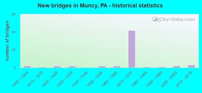
- New bridges - historical statistics
- 21900-1909
- 11910-1919
- 21920-1929
- 21930-1939
- 21950-1959
- 21960-1969
- 421970-1979
- 11980-1989
- 11990-1999
- 22000-2009
- 32010-2019

- Reconstructed bridges - Historical Statistics
- 31980-1989
- 101990-1999
- 12000-2009
- 12010-2019
- 12020-2022


- Bridge Condition - Deck
- 25.0%Very good
- 44.4%Good
- 16.7%Satisfactory
- 13.9%Fair

- Bridge Condition - Superstructure
- 13.5%Very good
- 37.8%Good
- 35.1%Satisfactory
- 10.8%Fair
- 2.7%Imminent failure

- Bridge Condition - Substructure
- 56.8%Good
- 32.4%Satisfactory
- 8.1%Fair
- 2.7%Critical

- Bridge Condition - Channel
- 10.3%Very good
- 17.2%Good
- 31.0%Satisfactory
- 27.6%Fair
- 13.8%Poor

- Bridge Condition - Culverts
- 40.0%Very good
- 60.0%Good
Find on map >> Show street view
Structure Number: 24656, Location: 1 MI N OF HALLS STATION (Lat: 41.241250, Lng: -76.817214), Route carried "on" structure: Interstate 180, Year Built: 1975, Year Reconstructed: 2004, Status: Open, Structure Length: 2.83m (9.28ft), Average Daily Traffic: 11,385 (year 2021), Truck Traffic: 14%, Average Future Daily Traffic: 13,316 (year 2032), Design Load: HL 93, Features Intersected: OVER CARPENTERS RUN
Minimum Vertical Clearance: 30+ m (98+ ft), Kilometerpoint: 20.725, Lanes on structure: 2, Base Highway Network: Yes, Owner: State Highway Agency, Approaching Roadway Width: 11.6m (38.1ft), Skew: 12 degrees, Material/Design: Prestressed concrete, Design/Construction: Stringer/Multi-beam, Number Of Spans In Main Unit: 1, Length of Maximum Span: 27.1m (88.9ft), Curb or Sidewalk Widths: Left: 0.2m (0.7ft), Right: 0.2m (0.7ft), Curb-To-Curb Width: 12.0m (39.4ft), Out-to-Out Width: 13.0m (42.7ft)
Condition: Deck: Good, Superstructure: Good, Substructure: Good, Channel: Good, Operating Rating: 95.3 metric tons, Method Used To Determine Operating Rating: Load Factor (LF), Inventory Rating: 41.7 metric tons, Method Used To Determine Inventory Rating: Load Factor (LF), Structural Evaluation: Better than present minimum criteria, Deck Geometry: Equal to present minimum criteria, Waterway Adequacy: Superior to present desirable criteria, Approach Roadway Alignment: Equal to present desirable criteria, Length Of Structure Improvement: 3.60m (11.81ft), Designated Inspection Frequency: Every 48 months, Inspection Date: January 2020, Deck Structure Type: Concrete Cast-file-Place, Wearing Surface/Protective System: Wearing Surface: Epoxy Overlay, Deck Protection: Epoxy Coated Reinforcing
Find on map >> Show street view
Structure Number: 24658, Location: 1 MI N OF HALLS STATION (Lat: 41.241406, Lng: -76.816956), Route carried "on" structure: Interstate 180, Year Built: 1975, Year Reconstructed: 2004, Status: Open, Structure Length: 2.83m (9.28ft), Average Daily Traffic: 12,498 (year 2021), Truck Traffic: 13%, Average Future Daily Traffic: 12,693 (year 2032), Design Load: HS 20, Features Intersected: OVER CARPENTERS RUN
Minimum Vertical Clearance: 30+ m (98+ ft), Kilometerpoint: 20.719, Lanes on structure: 2, Base Highway Network: Yes, Owner: State Highway Agency, Approaching Roadway Width: 11.6m (38.1ft), Skew: 12 degrees, Material/Design: Prestressed concrete, Design/Construction: Stringer/Multi-beam, Number Of Spans In Main Unit: 1, Length of Maximum Span: 26.8m (87.9ft), Curb-To-Curb Width: 12.0m (39.4ft), Out-to-Out Width: 13.0m (42.7ft)
Condition: Deck: Good, Superstructure: Good, Substructure: Good, Channel: Good, Operating Rating: 94.3 metric tons, Method Used To Determine Operating Rating: Load Factor (LF), Inventory Rating: 29.9 metric tons, Method Used To Determine Inventory Rating: Load Factor (LF), Structural Evaluation: Better than present minimum criteria, Deck Geometry: Equal to present minimum criteria, Waterway Adequacy: Superior to present desirable criteria, Approach Roadway Alignment: Equal to present desirable criteria, Length Of Structure Improvement: 3.60m (11.81ft), Designated Inspection Frequency: Every 24 months, Inspection Date: January 2020, Deck Structure Type: Concrete Cast-file-Place, Wearing Surface/Protective System: Wearing Surface: Epoxy Overlay, Deck Protection: Epoxy Coated Reinforcing
Find on map >> Show street view
Structure Number: 24659, Location: HALLS STATION (Lat: 41.237781, Lng: -76.809456), Route carried "on" structure: Interstate 180, Year Built: 1975, Status: Open, Structure Length: 5.85m (19.19ft), Average Daily Traffic: 9,440 (year 2021), Truck Traffic: 20%, Average Future Daily Traffic: 13,316 (year 2032), Design Load: HS 20, Features Intersected: I 180 OVER SR 2036
Minimum Vertical Clearance: 30+ m (98+ ft), Kilometerpoint: 21.528, Lanes on structure: 2, Lanes under structure: 2, Base Highway Network: Yes, Owner: State Highway Agency, Approaching Roadway Width: 11.6m (38.1ft), Skew: 13 degrees, Material/Design: Prestressed concrete, Design/Construction: Stringer/Multi-beam, Number Of Spans In Main Unit: 3, Length of Maximum Span: 30.2m (99.1ft), Curb-To-Curb Width: 12.4m (40.7ft), Out-to-Out Width: 13.2m (43.3ft)
Condition: Deck: Very good, Superstructure: Satisfactory, Substructure: Good, Operating Rating: 67.1 metric tons, Method Used To Determine Operating Rating: Load Factor (LF), Inventory Rating: 39.9 metric tons, Method Used To Determine Inventory Rating: Load Factor (LF), Structural Evaluation: Equal to present minimum criteria, Deck Geometry: Better than present minimum criteria, Underclear: Equal to present minimum criteria, Approach Roadway Alignment: Equal to present desirable criteria, Length Of Structure Improvement: 3.80m (12.47ft), Designated Inspection Frequency: Every 24 months, Inspection Date: January 2020, Bridge Improvement Cost: $14,000, Roadway Improvement Cost: $42,000, Total Project Cost: $191,000, Deck Structure Type: Concrete Cast-file-Place, Wearing Surface/Protective System: Wearing Surface: Epoxy Overlay, Deck Protection: Epoxy Coated Reinforcing
Find on map >> Show street view
Structure Number: 2466, Location: HALLS STATION (Lat: 41.237917, Lng: -76.809175), Route carried "on" structure: Interstate 180, Year Built: 1975, Year Reconstructed: 2001, Status: Open, Structure Length: 5.85m (19.19ft), Average Daily Traffic: 9,624 (year 2021), Truck Traffic: 17%, Average Future Daily Traffic: 12,693 (year 2032), Design Load: HS 20, Features Intersected: OVER SR 0220
Minimum Vertical Clearance: 30+ m (98+ ft), Kilometerpoint: 21.519, Lanes on structure: 2, Lanes under structure: 2, Base Highway Network: Yes, Owner: State Highway Agency, Approaching Roadway Width: 11.6m (38.1ft), Skew: 13 degrees, Material/Design: Prestressed concrete, Design/Construction: Stringer/Multi-beam, Number Of Spans In Main Unit: 3, Length of Maximum Span: 30.2m (99.1ft), Curb-To-Curb Width: 12.4m (40.7ft), Out-to-Out Width: 13.2m (43.3ft)
Condition: Deck: Very good, Superstructure: Satisfactory, Substructure: Satisfactory, Operating Rating: 66.2 metric tons, Method Used To Determine Operating Rating: Load Factor (LF), Inventory Rating: 38.1 metric tons, Method Used To Determine Inventory Rating: Load Factor (LF), Structural Evaluation: Equal to present minimum criteria, Deck Geometry: Better than present minimum criteria, Underclear: Equal to present minimum criteria, Approach Roadway Alignment: Equal to present desirable criteria, Length Of Structure Improvement: 5.90m (19.36ft), Designated Inspection Frequency: Every 24 months, Inspection Date: January 2020, Deck Structure Type: Concrete Cast-file-Place, Wearing Surface/Protective System: Wearing Surface: Epoxy Overlay, Deck Protection: Epoxy Coated Reinforcing
Find on map >> Show street view
Structure Number: 24662, Location: 1.5 MI EAST OF MUNCY (Lat: 41.227808, Lng: -76.794886), Route carried "on" structure: Interstate 180, Year Built: 1973, Year Reconstructed: 2000, Status: Open, Structure Length: 2.96m (9.71ft), Average Daily Traffic: 9,440 (year 2021), Truck Traffic: 20%, Average Future Daily Traffic: 13,316 (year 2032), Design Load: HS 20, Features Intersected: WOLF RUN
Minimum Vertical Clearance: 30+ m (98+ ft), Kilometerpoint: 23.123, Lanes on structure: 2, Base Highway Network: Yes, Owner: State Highway Agency, Approaching Roadway Width: 11.6m (38.1ft), Skew: 12 degrees, Material/Design: Prestressed concrete, Design/Construction: Stringer/Multi-beam, Number Of Spans In Main Unit: 1, Length of Maximum Span: 27.7m (90.9ft), Curb or Sidewalk Widths: Left: 0.2m (0.7ft), Right: 0.2m (0.7ft), Curb-To-Curb Width: 11.9m (39.0ft), Out-to-Out Width: 13.2m (43.3ft)
Condition: Deck: Good, Superstructure: Good, Substructure: Good, Channel: Satisfactory, Inventory Rating: 41.7 metric tons, Method Used To Determine Inventory Rating: Load Factor (LF), Structural Evaluation: Better than present minimum criteria, Deck Geometry: Equal to present minimum criteria, Waterway Adequacy: Superior to present desirable criteria, Approach Roadway Alignment: Equal to present desirable criteria, Length Of Structure Improvement: 3.70m (12.14ft), Designated Inspection Frequency: Every 48 months, Inspection Date: January 2020, Deck Structure Type: Concrete Cast-file-Place, Wearing Surface/Protective System: Wearing Surface: Epoxy Overlay
Find on map >> Show street view
Structure Number: 24663, Location: 1.5 MI EAST OF MUNCY (Lat: 41.228211, Lng: -76.794625), Route carried "on" structure: Interstate 180, Year Built: 1973, Year Reconstructed: 1993, Status: Open, Structure Length: 2.83m (9.28ft), Average Daily Traffic: 9,624 (year 2021), Truck Traffic: 17%, Average Future Daily Traffic: 12,693 (year 2032), Design Load: HS 20, Features Intersected: OVER WOLF RUN
Minimum Vertical Clearance: 30+ m (98+ ft), Kilometerpoint: 23.133, Lanes on structure: 2, Base Highway Network: Yes, Owner: State Highway Agency, Approaching Roadway Width: 11.6m (38.1ft), Skew: 12 degrees, Material/Design: Prestressed concrete, Design/Construction: Stringer/Multi-beam, Number Of Spans In Main Unit: 1, Length of Maximum Span: 28.0m (91.9ft), Curb or Sidewalk Widths: Left: 0.2m (0.7ft), Right: 0.2m (0.7ft), Curb-To-Curb Width: 12.0m (39.4ft), Out-to-Out Width: 13.2m (43.3ft)
Condition: Deck: Good, Superstructure: Good, Substructure: Good, Channel: Satisfactory, Inventory Rating: 41.7 metric tons, Method Used To Determine Inventory Rating: Load Factor (LF), Structural Evaluation: Better than present minimum criteria, Deck Geometry: Equal to present minimum criteria, Waterway Adequacy: Superior to present desirable criteria, Approach Roadway Alignment: Equal to present desirable criteria, Length Of Structure Improvement: 2.80m (9.19ft), Designated Inspection Frequency: Every 48 months, Inspection Date: January 2020, Deck Structure Type: Concrete Cast-file-Place, Wearing Surface/Protective System: Wearing Surface: Epoxy Overlay
Find on map >> Show street view
Structure Number: 24664, Location: 1 MILE NW OF MUNCY (Lat: 41.219806, Lng: -76.783592), Route carried "on" structure: Interstate 180, Year Built: 1973, Status: Open, Structure Length: 6.52m (21.39ft), Average Daily Traffic: 9,440 (year 2021), Truck Traffic: 20%, Average Future Daily Traffic: 13,316 (year 2032), Design Load: HS 20, Features Intersected: OVER MUNCY CREEK
Minimum Vertical Clearance: 30+ m (98+ ft), Kilometerpoint: 24.765, Lanes on structure: 2, Base Highway Network: Yes, Owner: State Highway Agency, Approaching Roadway Width: 11.6m (38.1ft), Skew: 10 degrees, Material/Design: Prestressed concrete, Design/Construction: Stringer/Multi-beam, Number Of Spans In Main Unit: 3, Length of Maximum Span: 21.6m (70.9ft), Curb-To-Curb Width: 11.9m (39.0ft), Out-to-Out Width: 13.2m (43.3ft)
Condition: Deck: Good, Superstructure: Satisfactory, Substructure: Satisfactory, Channel: Poor, Operating Rating: 75.3 metric tons, Method Used To Determine Operating Rating: Load Factor (LF), Inventory Rating: 33.6 metric tons, Method Used To Determine Inventory Rating: Load Factor (LF), Structural Evaluation: Equal to present minimum criteria, Deck Geometry: Equal to present minimum criteria, Waterway Adequacy: Superior to present desirable criteria, Approach Roadway Alignment: Equal to present desirable criteria, Length Of Structure Improvement: 7.50m (24.61ft), Designated Inspection Frequency: Every 24 months, Inspection Date: June 2020, Bridge Improvement Cost: $16,000, Roadway Improvement Cost: $46,000, Total Project Cost: $210,000, Deck Structure Type: Concrete Cast-file-Place, Wearing Surface/Protective System: Wearing Surface: Latex Concrete
Find on map >> Show street view
Structure Number: 24665, Location: 1 MI NW OF MUNCY (Lat: 41.219997, Lng: -76.783417), Route carried "on" structure: Interstate 180, Year Built: 1973, Status: Open, Structure Length: 6.52m (21.39ft), Average Daily Traffic: 9,624 (year 2021), Truck Traffic: 17%, Average Future Daily Traffic: 12,693 (year 2032), Design Load: HS 20, Features Intersected: OVER MUNCY CREEK
Minimum Vertical Clearance: 30+ m (98+ ft), Kilometerpoint: 24.766, Lanes on structure: 2, Base Highway Network: Yes, Owner: State Highway Agency, Approaching Roadway Width: 11.6m (38.1ft), Skew: 10 degrees, Material/Design: Prestressed concrete, Design/Construction: Stringer/Multi-beam, Number Of Spans In Main Unit: 3, Length of Maximum Span: 21.6m (70.9ft), Curb-To-Curb Width: 11.9m (39.0ft), Out-to-Out Width: 13.2m (43.3ft)
Condition: Deck: Good, Superstructure: Satisfactory, Substructure: Fair, Channel: Fair, Operating Rating: 67.1 metric tons, Method Used To Determine Operating Rating: Load Factor (LF), Inventory Rating: 35.4 metric tons, Method Used To Determine Inventory Rating: Load Factor (LF), Structural Evaluation: Somewhat better than minimum adequacy, Deck Geometry: Equal to present minimum criteria, Waterway Adequacy: Superior to present desirable criteria, Approach Roadway Alignment: Equal to present desirable criteria, Length Of Structure Improvement: 6.60m (21.65ft), Designated Inspection Frequency: Every 24 months, Inspection Date: June 2020, Bridge Improvement Cost: $20,000, Roadway Improvement Cost: $60,000, Total Project Cost: $273,000, Deck Structure Type: Concrete Cast-file-Place, Wearing Surface/Protective System: Wearing Surface: Bituminous, Membrane: Preformed Fabric
Find on map >> Show street view
Structure Number: 24668, Location: 1 MI E OF MUNCY (Lat: 41.210756, Lng: -76.770975), Route carried "on" structure: Interstate 180, Year Built: 1973, Year Reconstructed: 2003, Status: Open, Structure Length: 5.61m (18.41ft), Average Daily Traffic: 7,558 (year 2021), Truck Traffic: 24%, Average Future Daily Traffic: 10,490 (year 2032), Design Load: HL 93, Features Intersected: E.B. OVER S.R. 405
Minimum Vertical Clearance: 30+ m (98+ ft), Kilometerpoint: 26.232, Lanes on structure: 2, Lanes under structure: 2, Base Highway Network: Yes, Owner: State Highway Agency, Approaching Roadway Width: 15.2m (49.9ft), Skew: 10 degrees, Material/Design: Prestressed concrete, Design/Construction: Stringer/Multi-beam, Number Of Spans In Main Unit: 3, Length of Maximum Span: 32.3m (106.0ft), Curb-To-Curb Width: 16.0m (52.5ft), Out-to-Out Width: 16.9m (55.4ft)
Condition: Deck: Good, Superstructure: Satisfactory, Substructure: Satisfactory, Operating Rating: 83.5 metric tons, Method Used To Determine Operating Rating: Load Factor (LF), Inventory Rating: 50.8 metric tons, Method Used To Determine Inventory Rating: Load Factor (LF), Structural Evaluation: Equal to present minimum criteria, Deck Geometry: Superior to present desirable criteria, Underclear: Equal to present minimum criteria, Approach Roadway Alignment: Equal to present desirable criteria, Length Of Structure Improvement: 5.60m (18.37ft), Designated Inspection Frequency: Every 24 months, Inspection Date: Febuary 2020, Deck Structure Type: Concrete Cast-file-Place, Wearing Surface/Protective System: Wearing Surface: Epoxy Overlay, Deck Protection: Epoxy Coated Reinforcing
Find on map >> Show street view
Structure Number: 24669, Location: 1 MI E OF MUNCY (Lat: 41.207278, Lng: -76.769208), Route carried "on" structure: Interstate 180, Year Built: 1973, Year Reconstructed: 2003, Status: Open, Structure Length: 4.24m (13.91ft), Average Daily Traffic: 7,558 (year 2021), Truck Traffic: 24%, Average Future Daily Traffic: 10,490 (year 2032), Design Load: HL 93, Features Intersected: E.B. OVER S.R. 2044
Minimum Vertical Clearance: 30+ m (98+ ft), Kilometerpoint: 26.232, Lanes on structure: 2, Lanes under structure: 2, Base Highway Network: Yes, Owner: State Highway Agency, Approaching Roadway Width: 15.2m (49.9ft), Skew: 11 degrees, Material/Design: Prestressed concrete, Design/Construction: Stringer/Multi-beam, Number Of Spans In Main Unit: 3, Length of Maximum Span: 22.3m (73.2ft), Curb-To-Curb Width: 16.7m (54.8ft), Out-to-Out Width: 17.6m (57.7ft)
Condition: Deck: Good, Superstructure: Good, Substructure: Satisfactory, Operating Rating: 85.3 metric tons, Method Used To Determine Operating Rating: Load Factor (LF), Inventory Rating: 39.0 metric tons, Method Used To Determine Inventory Rating: Load Factor (LF), Structural Evaluation: Equal to present minimum criteria, Deck Geometry: Superior to present desirable criteria, Underclear: Better than present minimum criteria, Approach Roadway Alignment: Equal to present desirable criteria, Length Of Structure Improvement: 4.20m (13.78ft), Designated Inspection Frequency: Every 48 months, Inspection Date: Febuary 2020, Bridge Improvement Cost: $13,000, Roadway Improvement Cost: $50,000, Total Project Cost: $178,000, Deck Structure Type: Concrete Cast-file-Place, Wearing Surface/Protective System: Wearing Surface: Epoxy Overlay, Deck Protection: Epoxy Coated Reinforcing
Find on map >> Show street view
Structure Number: 2467, Location: 1 MI E OF MUNCY (Lat: 41.210861, Lng: -76.770711), Route carried "on" structure: Interstate 180, Year Built: 1973, Status: Open, Structure Length: 5.61m (18.41ft), Average Daily Traffic: 7,301 (year 2021), Truck Traffic: 24%, Average Future Daily Traffic: 10,613 (year 2032), Design Load: HL 93, Features Intersected: W.B. OVER S.R. 405
Minimum Vertical Clearance: 30+ m (98+ ft), Kilometerpoint: 26.247, Lanes on structure: 2, Lanes under structure: 2, Base Highway Network: Yes, Owner: State Highway Agency, Approaching Roadway Width: 15.2m (49.9ft), Skew: 10 degrees, Material/Design: Prestressed concrete, Design/Construction: Stringer/Multi-beam, Number Of Spans In Main Unit: 3, Length of Maximum Span: 32.3m (106.0ft), Curb-To-Curb Width: 16.5m (54.1ft), Out-to-Out Width: 16.5m (54.1ft)
Condition: Deck: Very good, Superstructure: Good, Substructure: Satisfactory, Operating Rating: 81.6 metric tons, Method Used To Determine Operating Rating: Load Factor (LF), Inventory Rating: 49.9 metric tons, Method Used To Determine Inventory Rating: Load Factor (LF), Structural Evaluation: Equal to present minimum criteria, Deck Geometry: Superior to present desirable criteria, Underclear: Better than present minimum criteria, Approach Roadway Alignment: Equal to present desirable criteria, Length Of Structure Improvement: 5.60m (18.37ft), Designated Inspection Frequency: Every 48 months, Inspection Date: Febuary 2020, Deck Structure Type: Concrete Cast-file-Place, Wearing Surface/Protective System: Wearing Surface: Epoxy Overlay, Deck Protection: Epoxy Coated Reinforcing
Find on map >> Show street view
Structure Number: 24671, Location: 1 MI E OF MUNCY (Lat: 41.207408, Lng: -76.768931), Route carried "on" structure: Interstate 180, Year Built: 1973, Year Reconstructed: 2004, Status: Open, Structure Length: 4.51m (14.80ft), Average Daily Traffic: 7,301 (year 2021), Truck Traffic: 24%, Average Future Daily Traffic: 10,613 (year 2032), Design Load: HS 20, Features Intersected: W.B. OVER S.R. 2044
Minimum Vertical Clearance: 30+ m (98+ ft), Kilometerpoint: 26.247, Lanes on structure: 2, Lanes under structure: 2, Base Highway Network: Yes, Owner: State Highway Agency, Approaching Roadway Width: 14.6m (47.9ft), Skew: 11 degrees, Material/Design: Prestressed concrete, Design/Construction: Stringer/Multi-beam, Number Of Spans In Main Unit: 3, Length of Maximum Span: 22.3m (73.2ft), Curb or Sidewalk Widths: Left: 0.2m (0.7ft), Right: 0.2m (0.7ft), Curb-To-Curb Width: 15.6m (51.2ft), Out-to-Out Width: 16.9m (55.4ft)
Condition: Deck: Satisfactory, Superstructure: Good, Substructure: Good, Operating Rating: 70.8 metric tons, Method Used To Determine Operating Rating: Load Factor (LF), Inventory Rating: 32.7 metric tons, Method Used To Determine Inventory Rating: Load Factor (LF), Structural Evaluation: Better than present minimum criteria, Deck Geometry: Superior to present desirable criteria, Underclear: Superior to present desirable criteria, Approach Roadway Alignment: Equal to present desirable criteria, Length Of Structure Improvement: 4.50m (14.76ft), Designated Inspection Frequency: Every 24 months, Inspection Date: Febuary 2020, Bridge Improvement Cost: $67,000, Roadway Improvement Cost: $196,000, Total Project Cost: $900,000, Deck Structure Type: Concrete Cast-file-Place, Wearing Surface/Protective System: Wearing Surface: Epoxy Overlay, Deck Protection: Epoxy Coated Reinforcing
Find on map >> Show street view
Structure Number: 24672, Location: 1 MI SE OF MUNCY (Lat: 41.201361, Lng: -76.769075), Route carried "on" structure: Interstate 180, Year Built: 1973, Year Reconstructed: 2003, Status: Open, Structure Length: 3.29m (10.79ft), Average Daily Traffic: 7,558 (year 2021), Truck Traffic: 24%, Average Future Daily Traffic: 10,490 (year 2032), Design Load: HL 93, Features Intersected: E.B. OVER S.R. 2061
Minimum Vertical Clearance: 30+ m (98+ ft), Kilometerpoint: 27.122, Lanes on structure: 2, Lanes under structure: 2, Base Highway Network: Yes, Owner: State Highway Agency, Approaching Roadway Width: 11.6m (38.1ft), Skew: 10 degrees, Material/Design: Prestressed concrete, Design/Construction: Stringer/Multi-beam, Number Of Spans In Main Unit: 1, Length of Maximum Span: 31.7m (104.0ft), Curb or Sidewalk Widths: Left: 0.2m (0.7ft), Right: 0.2m (0.7ft), Curb-To-Curb Width: 12.3m (40.4ft), Out-to-Out Width: 13.2m (43.3ft)
Condition: Deck: Very good, Superstructure: Good, Substructure: Satisfactory, Inventory Rating: 27.2 metric tons, Method Used To Determine Inventory Rating: Load Factor (LF), Structural Evaluation: Equal to present minimum criteria, Deck Geometry: Better than present minimum criteria, Underclear: Equal to present minimum criteria, Approach Roadway Alignment: Equal to present desirable criteria, Length Of Structure Improvement: 3.30m (10.83ft), Designated Inspection Frequency: Every 24 months, Inspection Date: Febuary 2020, Deck Structure Type: Concrete Cast-file-Place, Wearing Surface/Protective System: Wearing Surface: Epoxy Overlay, Deck Protection: Epoxy Coated Reinforcing
Find on map >> Show street view
Structure Number: 24673, Location: 1 MI SE OF MUNCY (Lat: 41.201353, Lng: -76.768772), Route carried "on" structure: Interstate 180, Year Built: 1973, Status: Open, Structure Length: 3.29m (10.79ft), Average Daily Traffic: 7,301 (year 2021), Truck Traffic: 24%, Average Future Daily Traffic: 10,613 (year 2032), Design Load: HL 93, Features Intersected: W.B. OVER S.R. 2061
Minimum Vertical Clearance: 30+ m (98+ ft), Kilometerpoint: 27.156, Lanes on structure: 2, Lanes under structure: 2, Base Highway Network: Yes, Owner: State Highway Agency, Approaching Roadway Width: 11.6m (38.1ft), Skew: 10 degrees, Material/Design: Prestressed concrete, Design/Construction: Stringer/Multi-beam, Number Of Spans In Main Unit: 1, Length of Maximum Span: 31.7m (104.0ft), Curb-To-Curb Width: 12.3m (40.4ft), Out-to-Out Width: 13.2m (43.3ft)
Condition: Deck: Very good, Superstructure: Good, Substructure: Good, Inventory Rating: 27.2 metric tons, Method Used To Determine Inventory Rating: Load Factor (LF), Structural Evaluation: Equal to present minimum criteria, Deck Geometry: Better than present minimum criteria, Underclear: Equal to present minimum criteria, Approach Roadway Alignment: Equal to present desirable criteria, Length Of Structure Improvement: 3.30m (10.83ft), Designated Inspection Frequency: Every 24 months, Inspection Date: Febuary 2020, Deck Structure Type: Concrete Cast-file-Place, Wearing Surface/Protective System: Wearing Surface: Epoxy Overlay, Deck Protection: Epoxy Coated Reinforcing
Find on map >> Show street view
Structure Number: 24674, Location: 1 MI S OF MUNCY (Lat: 41.193142, Lng: -76.770069), Route carried "on" structure: Interstate 180, Year Built: 1973, Status: Open, Structure Length: 1.01m (3.31ft), Average Daily Traffic: 14,859 (year 2021), Truck Traffic: 24%, Average Future Daily Traffic: 21,103 (year 2032), Design Load: HS 20, Features Intersected: GLADE RUN
Minimum Vertical Clearance: 30+ m (98+ ft), Kilometerpoint: 27.893, Lanes on structure: 6, Base Highway Network: Yes, Owner: State Highway Agency, Approaching Roadway Width: 23.2m (76.1ft), Skew: 22 degrees, Material/Design: Concrete, Design/Construction: Culvert, Number Of Spans In Main Unit: 2, Length of Maximum Span: 5.2m (17.1ft)
Condition: Channel: Fair, Culverts: Good, Operating Rating: 76.2 metric tons, Method Used To Determine Operating Rating: Load Factor (LF), Inventory Rating: 45.4 metric tons, Method Used To Determine Inventory Rating: Load Factor (LF), Structural Evaluation: Better than present minimum criteria, Waterway Adequacy: Superior to present desirable criteria, Approach Roadway Alignment: Equal to present desirable criteria, Length Of Structure Improvement: 1.00m (3.28ft), Designated Inspection Frequency: Every 48 months, Inspection Date: Febuary 2020
Find on map >> Show street view
Structure Number: 24675, Location: .5 MI S OF MUNCY (Lat: 41.187631, Lng: -76.785247), Route carried "on" structure: Interstate 180, Year Built: 1973, Year Reconstructed: 2003, Status: Open, Structure Length: 3.35m (10.99ft), Average Daily Traffic: 7,558 (year 2021), Truck Traffic: 24%, Average Future Daily Traffic: 10,490 (year 2032), Design Load: HL 93, Features Intersected: E.B. OVER S.R. 2014
Minimum Vertical Clearance: 30+ m (98+ ft), Kilometerpoint: 29.723, Lanes on structure: 2, Lanes under structure: 2, Base Highway Network: Yes, Owner: State Highway Agency, Approaching Roadway Width: 11.6m (38.1ft), Skew: 12 degrees, Material/Design: Prestressed concrete, Design/Construction: Stringer/Multi-beam, Number Of Spans In Main Unit: 1, Length of Maximum Span: 32.0m (105.0ft), Curb-To-Curb Width: 11.9m (39.0ft), Out-to-Out Width: 13.2m (43.3ft)
Condition: Deck: Good, Superstructure: Satisfactory, Substructure: Good, Inventory Rating: 22.7 metric tons, Method Used To Determine Inventory Rating: Load Factor (LF), Structural Evaluation: Somewhat better than minimum adequacy, Deck Geometry: Equal to present minimum criteria, Underclear: Equal to present minimum criteria, Approach Roadway Alignment: Equal to present desirable criteria, Length Of Structure Improvement: 3.40m (11.15ft), Designated Inspection Frequency: Every 24 months, Inspection Date: Febuary 2020, Deck Structure Type: Concrete Cast-file-Place, Wearing Surface/Protective System: Wearing Surface: Epoxy Overlay, Deck Protection: Epoxy Coated Reinforcing
Find on map >> Show street view
Structure Number: 24676, Location: .5 MI S OF MUNCY (Lat: 41.187319, Lng: -76.785294), Route carried "on" structure: Interstate 180, Year Built: 1973, Year Reconstructed: 2004, Status: Open, Structure Length: 3.35m (10.99ft), Average Daily Traffic: 7,301 (year 2021), Truck Traffic: 24%, Average Future Daily Traffic: 10,613 (year 2032), Design Load: HS 20, Features Intersected: W.B. OVER S.R. 2014
Minimum Vertical Clearance: 30+ m (98+ ft), Kilometerpoint: 29.802, Lanes on structure: 2, Lanes under structure: 2, Base Highway Network: Yes, Owner: State Highway Agency, Approaching Roadway Width: 11.3m (37.1ft), Skew: 13 degrees, Material/Design: Prestressed concrete, Design/Construction: Stringer/Multi-beam, Number Of Spans In Main Unit: 1, Length of Maximum Span: 32.0m (105.0ft), Curb or Sidewalk Widths: Left: 0.2m (0.7ft), Right: 0.2m (0.7ft), Curb-To-Curb Width: 11.9m (39.0ft), Out-to-Out Width: 13.2m (43.3ft)
Condition: Deck: Good, Superstructure: Good, Substructure: Good, Inventory Rating: 22.7 metric tons, Method Used To Determine Inventory Rating: Load Factor (LF), Structural Evaluation: Somewhat better than minimum adequacy, Deck Geometry: Equal to present minimum criteria, Underclear: Equal to present minimum criteria, Approach Roadway Alignment: Equal to present desirable criteria, Length Of Structure Improvement: 3.40m (11.15ft), Designated Inspection Frequency: Every 24 months, Inspection Date: Febuary 2020, Deck Structure Type: Concrete Cast-file-Place, Wearing Surface/Protective System: Wearing Surface: Epoxy Overlay, Deck Protection: Epoxy Coated Reinforcing
Find on map >> Show street view
Structure Number: 24745, Location: MUNCY PIN/HANGER RIVER BR (Lat: 41.204472, Lng: -76.804808), Route carried "on" structure: State highway 405, Year Built: 1959, Year Reconstructed: 2003, Status: Open, Structure Length: 65.04m (213.39ft), Average Daily Traffic: 3,968 (year 2020), Truck Traffic: 9%, Average Future Daily Traffic: 6,825 (year 2032), Design Load: HS 20, Features Intersected: LVRR,WB SUSQ RVR
Minimum Vertical Clearance: 30+ m (98+ ft), Kilometerpoint: 7.075, Lanes on structure: 2, Owner: State Highway Agency, Approaching Roadway Width: 9.8m (32.2ft), Material/Design: Steel continuous, Design/Construction: Girder and Floorbeam System, Number Of Spans In Main Unit: 11, Number Of Approach Spans: 7, Length of Maximum Span: 43.9m (144.0ft), Curb or Sidewalk Widths: Left: 0.5m (1.6ft), Right: 1.5m (4.9ft), Curb-To-Curb Width: 8.5m (27.9ft), Out-to-Out Width: 11.3m (37.1ft)
Condition: Deck: Good, Superstructure: Good, Substructure: Good, Channel: Very good, Operating Rating: 58.1 metric tons, Method Used To Determine Operating Rating: Load Factor (LF), Inventory Rating: 34.5 metric tons, Method Used To Determine Inventory Rating: Load Factor (LF), Structural Evaluation: Better than present minimum criteria, Deck Geometry: Meets minimum limits, Underclear: High priority of corrective action, Waterway Adequacy: Superior to present desirable criteria, Approach Roadway Alignment: Equal to present desirable criteria, Length Of Structure Improvement: 65.00m (213.25ft), Designated Inspection Frequency: Every 24 months, Critical Feature Inspection Frequency: Every 24 months, Underwater Inspection Frequency: Every 48 months, Other Special Inspection Frequency: Every 12 months, Inspection Date: August 2020, Critical Feature Inspection Date: August 2020, Underwater Inspection Date: August 2019, Other Special Inspection Date: August 2021, Bridge Improvement Cost: $200,000, Roadway Improvement Cost: $1,537,000, Total Project Cost: $5,537,000, Deck Structure Type: Concrete Cast-file-Place, Wearing Surface/Protective System: Wearing Surface: Monolithic Concrete, Deck Protection: Epoxy Coated Reinforcing
Find on map >> Show street view
Structure Number: 24746, Location: MUNCY BOROUGH (Lat: 41.205789, Lng: -76.783583), Route carried "on" structure: State highway 405, Year Built: 1919, Status: Open, Structure Length: 1.04m (3.41ft), Average Daily Traffic: 5,506 (year 2020), Truck Traffic: 10%, Average Future Daily Traffic: 8,572 (year 2032), Design Load: HS 20, Features Intersected: OVER GLADE RUN
Minimum Vertical Clearance: 30+ m (98+ ft), Kilometerpoint: 8.665, Lanes on structure: 2, Owner: State Highway Agency, Approaching Roadway Width: 7.9m (25.9ft), Material/Design: Concrete, Design/Construction: Tee Beam, Number Of Spans In Main Unit: 1, Length of Maximum Span: 9.8m (32.2ft), Curb or Sidewalk Widths: Left: 1.6m (5.2ft), Right: 1.6m (5.2ft), Curb-To-Curb Width: 7.9m (25.9ft), Out-to-Out Width: 11.6m (38.1ft)
Condition: Deck: Fair, Superstructure: Fair, Substructure: Fair, Channel: Poor, Operating Rating: 84.4 metric tons, Method Used To Determine Operating Rating: Load Factor (LF), Inventory Rating: 50.8 metric tons, Method Used To Determine Inventory Rating: Load Factor (LF), Structural Evaluation: Somewhat better than minimum adequacy, Deck Geometry: High priority of replacement, Waterway Adequacy: High priority of corrective action, Approach Roadway Alignment: Equal to present desirable criteria, Length Of Structure Improvement: 1.00m (3.28ft), Designated Inspection Frequency: Every 24 months, Inspection Date: Febuary 2020, Bridge Improvement Cost: $11,000, Roadway Improvement Cost: $50,000, Total Project Cost: $153,000, Deck Structure Type: Concrete Cast-file-Place, Wearing Surface/Protective System: Wearing Surface: Bituminous
Find on map >> Show street view
Structure Number: 24858, Location: 2 MILE SOUTHEAST OF MUNCY (Lat: 41.186217, Lng: -76.760458), Route carried "on" structure: State highway , Year Built: 1980, Status: Open, Structure Length: 1.01m (3.31ft), Average Daily Traffic: 128 (year 2022), Truck Traffic: 14%, Average Future Daily Traffic: 251 (year 2032), Design Load: HS 20, Features Intersected: OVER GLADE RUN, Facility Carried by Structure: SR 2009
Minimum Vertical Clearance: 30+ m (98+ ft), Kilometerpoint: 4.253, Lanes on structure: 2, Owner: State Highway Agency, Approaching Roadway Width: 6.1m (20.0ft), Skew: 4 degrees, Material/Design: Concrete, Design/Construction: Culvert, Number Of Spans In Main Unit: 1, Length of Maximum Span: 9.1m (29.9ft), Curb-To-Curb Width: 8.6m (28.2ft), Out-to-Out Width: 9.9m (32.5ft)
Condition: Channel: Satisfactory, Culverts: Good, Operating Rating: 54.4 metric tons, Method Used To Determine Operating Rating: Field evaluation and documented engineering judgment, Inventory Rating: 32.7 metric tons, Method Used To Determine Inventory Rating: Field evaluation and documented engineering judgment, Structural Evaluation: Better than present minimum criteria, Deck Geometry: Equal to present minimum criteria, Waterway Adequacy: Better than present minimum criteria, Approach Roadway Alignment: Equal to present desirable criteria, Length Of Structure Improvement: 1.00m (3.28ft), Designated Inspection Frequency: Every 24 months, Inspection Date: Febuary 2020, Wearing Surface/Protective System: Wearing Surface: Bituminous, Membrane: Preformed Fabric
Find on map >> Show street view
Structure Number: 24875, Location: HALLS STATION (Lat: 41.235147, Lng: -76.822100), Route carried "on" structure: State highway , Year Built: 1996, Status: Open, Structure Length: 1.40m (4.59ft), Average Daily Traffic: 10,302 (year 2022), Truck Traffic: 5%, Average Future Daily Traffic: 9,727 (year 2032), Design Load: HS 25 or greater, Features Intersected: CARPENTERS RUN, Facility Carried by Structure: S.R. 2014
Minimum Vertical Clearance: 30+ m (98+ ft), Kilometerpoint: 23.043, Lanes on structure: 4, Base Highway Network: Yes, Owner: State Highway Agency, Approaching Roadway Width: 18.6m (61.0ft), Material/Design: Prestressed concrete, Design/Construction: Box Beam or Girders - Multiple, Number Of Spans In Main Unit: 1, Length of Maximum Span: 13.7m (44.9ft), Curb or Sidewalk Widths: Left: 0.2m (0.7ft), Right: 0.2m (0.7ft), Curb-To-Curb Width: 18.7m (61.4ft), Out-to-Out Width: 19.8m (65.0ft)
Condition: Deck: Very good, Superstructure: Very good, Substructure: Good, Channel: Good, Inventory Rating: 56.2 metric tons, Method Used To Determine Inventory Rating: Load Factor (LF), Structural Evaluation: Better than present minimum criteria, Deck Geometry: Equal to present minimum criteria, Waterway Adequacy: Superior to present desirable criteria, Approach Roadway Alignment: Equal to present desirable criteria, Length Of Structure Improvement: 2.00m (6.56ft), Designated Inspection Frequency: Every 48 months, Inspection Date: January 2020, Deck Structure Type: Concrete Cast-file-Place, Wearing Surface/Protective System: Wearing Surface: Epoxy Overlay, Deck Protection: Epoxy Coated Reinforcing
Find on map >> Show street view
Structure Number: 24876, Location: 2 MI N OF MUNCY BOROUGH (Lat: 41.222744, Lng: -76.796150), Route carried "on" structure: State highway , Year Built: 1938, Year Reconstructed: 1986, Status: Open, Structure Length: 1.13m (3.71ft), Average Daily Traffic: 7,041 (year 2022), Truck Traffic: 4%, Average Future Daily Traffic: 11,242 (year 2032), Design Load: HS 20, Features Intersected: WOLF RUN, Facility Carried by Structure: SR 2014
Minimum Vertical Clearance: 30+ m (98+ ft), Kilometerpoint: 26.516, Lanes on structure: 2, Base Highway Network: Yes, Owner: State Highway Agency, Approaching Roadway Width: 6.7m (22.0ft), Skew: 4 degrees, Material/Design: Concrete, Design/Construction: Frame, Number Of Spans In Main Unit: 1, Length of Maximum Span: 9.1m (29.9ft), Curb-To-Curb Width: 15.2m (49.9ft), Out-to-Out Width: 16.2m (53.1ft)
Condition: Deck: Satisfactory, Superstructure: Satisfactory, Substructure: Fair, Channel: Fair, Operating Rating: 54.4 metric tons, Method Used To Determine Operating Rating: Field evaluation and documented engineering judgment, Inventory Rating: 32.7 metric tons, Method Used To Determine Inventory Rating: Field evaluation and documented engineering judgment, Structural Evaluation: Somewhat better than minimum adequacy, Deck Geometry: Superior to present desirable criteria, Waterway Adequacy: Superior to present desirable criteria, Approach Roadway Alignment: Equal to present desirable criteria, Length Of Structure Improvement: 1.10m (3.61ft), Designated Inspection Frequency: Every 24 months, Other Special Inspection Frequency: Every 12 months, Inspection Date: Febuary 2020, Other Special Inspection Date: Febuary 2021
Find on map >> Show street view
Structure Number: 24877, Location: 1 MI N OF MUNCY BORO. (Lat: 41.217572, Lng: -76.787161), Route carried "on" structure: State highway , Year Built: 1979, Status: Open, Structure Length: 8.75m (28.71ft), Average Daily Traffic: 8,885 (year 2022), Truck Traffic: 2%, Average Future Daily Traffic: 9,544 (year 2032), Design Load: HS 20, Features Intersected: MUNCY CREEK, Facility Carried by Structure: SR 2014
Minimum Vertical Clearance: 30+ m (98+ ft), Kilometerpoint: 27.327, Lanes on structure: 2, Owner: State Highway Agency, Approaching Roadway Width: 10.7m (35.1ft), Skew: 1 degrees, Material/Design: Prestressed concrete, Design/Construction: Stringer/Multi-beam, Number Of Spans In Main Unit: 3, Length of Maximum Span: 28.3m (92.8ft), Curb or Sidewalk Widths: Left: 0.2m (0.7ft), Right: 0.2m (0.7ft), Curb-To-Curb Width: 12.2m (40.0ft), Out-to-Out Width: 13.3m (43.6ft)
Condition: Deck: Good, Superstructure: Good, Substructure: Good, Channel: Good, Inventory Rating: 40.8 metric tons, Method Used To Determine Inventory Rating: Load Factor (LF), Structural Evaluation: Better than present minimum criteria, Deck Geometry: Somewhat better than minimum adequacy, Waterway Adequacy: Superior to present desirable criteria, Approach Roadway Alignment: Equal to present desirable criteria, Length Of Structure Improvement: 8.70m (28.54ft), Designated Inspection Frequency: Every 48 months, Inspection Date: August 2018, Deck Structure Type: Concrete Cast-file-Place, Wearing Surface/Protective System: Wearing Surface: Monolithic Concrete, Deck Protection: Epoxy Coated Reinforcing
Find on map >> Show street view
Structure Number: 24878, Location: 100 FT N MUNCY BORO (Lat: 41.211375, Lng: -76.786428), Route carried "on" structure: State highway , Year Built: 1978, Status: Open, Structure Length: 1.43m (4.69ft), Average Daily Traffic: 8,885 (year 2022), Truck Traffic: 2%, Average Future Daily Traffic: 9,544 (year 2032), Design Load: HS 20, Features Intersected: GLADE RUN, Facility Carried by Structure: SR 2014
Minimum Vertical Clearance: 30+ m (98+ ft), Kilometerpoint: 27.803, Lanes on structure: 2, Owner: State Highway Agency, Approaching Roadway Width: 9.8m (32.2ft), Skew: 3 degrees, Material/Design: Concrete, Design/Construction: Culvert, Number Of Spans In Main Unit: 2, Length of Maximum Span: 6.7m (22.0ft), Curb or Sidewalk Widths: Left: 1.5m (4.9ft), Right: 0.0m, Curb-To-Curb Width: 10.0m (32.8ft), Out-to-Out Width: 12.8m (42.0ft)
Condition: Channel: Fair, Culverts: Good, Operating Rating: 52.6 metric tons, Method Used To Determine Operating Rating: Load Factor (LF), Inventory Rating: 31.8 metric tons, Method Used To Determine Inventory Rating: Load Factor (LF), Structural Evaluation: Better than present minimum criteria, Deck Geometry: Meets minimum limits, Waterway Adequacy: Somewhat better than minimum adequacy, Approach Roadway Alignment: Equal to present desirable criteria, Length Of Structure Improvement: 1.10m (3.61ft), Designated Inspection Frequency: Every 24 months, Inspection Date: Febuary 2020, Wearing Surface/Protective System: Wearing Surface: Monolithic Concrete, Deck Protection: Epoxy Coated Reinforcing
Find on map >> Show street view
Structure Number: 24924, Location: MUNCY BORO (Lat: 41.202506, Lng: -76.781917), Route carried "on" structure: State highway , Year Built: 1974, Year Reconstructed: 2015, Status: Open, Structure Length: 1.16m (3.81ft), Average Daily Traffic: 3,179 (year 2021), Truck Traffic: 1%, Average Future Daily Traffic: 3,864 (year 2032), Design Load: HS 20, Features Intersected: OVER GLADE RUN, Facility Carried by Structure: SR 2044
Minimum Vertical Clearance: 30+ m (98+ ft), Kilometerpoint: 0.338, Lanes on structure: 2, Owner: State Highway Agency, Approaching Roadway Width: 8.5m (27.9ft), Skew: 3 degrees, Material/Design: Prestressed concrete, Design/Construction: Box Beam or Girders - Multiple, Number Of Spans In Main Unit: 1, Length of Maximum Span: 11.3m (37.1ft), Curb or Sidewalk Widths: Left: 1.5m (4.9ft), Right: 1.5m (4.9ft), Curb-To-Curb Width: 8.5m (27.9ft), Out-to-Out Width: 12.3m (40.4ft)
Condition: Deck: Good, Superstructure: Good, Substructure: Good, Channel: Fair, Operating Rating: 74.4 metric tons, Method Used To Determine Operating Rating: Assigned rating based on Load Factor Design (LFD) reported in metric tons, Inventory Rating: 37.2 metric tons, Method Used To Determine Inventory Rating: Assigned rating based on Load Factor Design (LFD) reported in metric tons, Structural Evaluation: Better than present minimum criteria, Deck Geometry: Meets minimum limits, Waterway Adequacy: Better than present minimum criteria, Approach Roadway Alignment: Equal to present desirable criteria, Length Of Structure Improvement: 1.20m (3.94ft), Designated Inspection Frequency: Every 24 months, Inspection Date: Febuary 2020, Wearing Surface/Protective System: Wearing Surface: Epoxy Overlay, Deck Protection: Epoxy Coated Reinforcing
Find on map >> Show street view
Structure Number: 24927, Location: LYCOMING MALL INTERCHANGE (Lat: 41.246294, Lng: -76.832931), Route carried "on" structure: State highway , Year Built: 1974, Status: Open, Structure Length: 9.39m (30.81ft), Average Daily Traffic: 3,188 (year 2021), Truck Traffic: 3%, Average Future Daily Traffic: 3,752 (year 2032), Design Load: HS 20, Features Intersected: OVER I-180 & RAMP B, Facility Carried by Structure: SR2049
Minimum Vertical Clearance: 30+ m (98+ ft), Kilometerpoint: 0.776, Lanes on structure: 2, Lanes under structure: 11, Owner: State Highway Agency, Approaching Roadway Width: 20.1m (65.9ft), Material/Design: Prestressed concrete, Design/Construction: Stringer/Multi-beam, Number Of Spans In Main Unit: 4, Length of Maximum Span: 32.3m (106.0ft), Curb or Sidewalk Widths: Left: 0.1m (0.3ft), Right: 0.1m (0.3ft), Curb-To-Curb Width: 19.5m (64.0ft), Out-to-Out Width: 20.5m (67.3ft)
Condition: Deck: Good, Superstructure: Satisfactory, Substructure: Good, Operating Rating: 69.9 metric tons, Method Used To Determine Operating Rating: Load Factor (LF), Inventory Rating: 35.4 metric tons, Method Used To Determine Inventory Rating: Load Factor (LF), Structural Evaluation: Equal to present minimum criteria, Deck Geometry: Superior to present desirable criteria, Underclear: Superior to present desirable criteria, Approach Roadway Alignment: Equal to present desirable criteria, Length Of Structure Improvement: 9.40m (30.84ft), Designated Inspection Frequency: Every 24 months, Inspection Date: January 2020, Deck Structure Type: Concrete Cast-file-Place, Wearing Surface/Protective System: Wearing Surface: Epoxy Overlay, Deck Protection: Epoxy Coated Reinforcing
Find on map >> Show street view
Structure Number: 24931, Location: 1 MI N OF MUNCY (Lat: 41.222053, Lng: -76.787011), Route carried "on" structure: State highway , Year Built: 1973, Status: Open, Structure Length: 7.71m (25.30ft), Average Daily Traffic: 1,701 (year 2022), Truck Traffic: 3%, Average Future Daily Traffic: 2,593 (year 2032), Design Load: HS 20, Features Intersected: OVER LR 1073 (I-180), Facility Carried by Structure: S.R.2053
Minimum Vertical Clearance: 30+ m (98+ ft), Kilometerpoint: 0.106, Lanes on structure: 2, Lanes under structure: 8, Owner: State Highway Agency, Approaching Roadway Width: 7.3m (24.0ft), Skew: 1 degrees, Material/Design: Prestressed concrete, Design/Construction: Stringer/Multi-beam, Number Of Spans In Main Unit: 4, Length of Maximum Span: 26.8m (87.9ft), Curb or Sidewalk Widths: Left: 0.2m (0.7ft), Right: 0.2m (0.7ft), Curb-To-Curb Width: 13.4m (44.0ft), Out-to-Out Width: 14.6m (47.9ft)
Condition: Deck: Good, Superstructure: Satisfactory, Substructure: Good, Operating Rating: 64.4 metric tons, Method Used To Determine Operating Rating: Load Factor (LF), Inventory Rating: 35.4 metric tons, Method Used To Determine Inventory Rating: Load Factor (LF), Structural Evaluation: Equal to present minimum criteria, Deck Geometry: Equal to present desirable criteria, Underclear: Equal to present minimum criteria, Approach Roadway Alignment: Equal to present desirable criteria, Length Of Structure Improvement: 7.70m (25.26ft), Designated Inspection Frequency: Every 24 months, Inspection Date: January 2020, Bridge Improvement Cost: $35,000, Roadway Improvement Cost: $104,000, Total Project Cost: $476,000, Deck Structure Type: Concrete Cast-file-Place, Wearing Surface/Protective System: Wearing Surface: Latex Concrete, Deck Protection: Epoxy Coated Reinforcing
Find on map >> Show street view
Structure Number: 24932, Location: 1MI E OF PENNSDALE (Lat: 41.241739, Lng: -76.777569), Route carried "on" structure: State highway , Year Built: 1957, Status: Open, Structure Length: 0.88m (2.89ft), Average Daily Traffic: 1,701 (year 2022), Truck Traffic: 3%, Average Future Daily Traffic: 2,593 (year 2032), Features Intersected: OVER WOLF RUN, Facility Carried by Structure: SR 2053
Minimum Vertical Clearance: 30+ m (98+ ft), Kilometerpoint: 2.570, Lanes on structure: 2, Owner: State Highway Agency, Approaching Roadway Width: 7.9m (25.9ft), Material/Design: Concrete, Design/Construction: Tee Beam, Number Of Spans In Main Unit: 1, Length of Maximum Span: 8.5m (27.9ft), Curb or Sidewalk Widths: Left: 0.5m (1.6ft), Right: 0.5m (1.6ft), Curb-To-Curb Width: 9.8m (32.2ft), Out-to-Out Width: 10.4m (34.1ft)
Condition: Deck: Satisfactory, Superstructure: Satisfactory, Substructure: Satisfactory, Channel: Poor, Operating Rating: 69.9 metric tons, Method Used To Determine Operating Rating: Load Factor (LF), Inventory Rating: 41.7 metric tons, Method Used To Determine Inventory Rating: Load Factor (LF), Structural Evaluation: Equal to present minimum criteria, Deck Geometry: Somewhat better than minimum adequacy, Waterway Adequacy: Superior to present desirable criteria, Approach Roadway Alignment: Equal to present desirable criteria, Length Of Structure Improvement: 0.90m (2.95ft), Designated Inspection Frequency: Every 24 months, Inspection Date: January 2020, Bridge Improvement Cost: $7,000, Roadway Improvement Cost: $50,000, Total Project Cost: $90,000, Deck Structure Type: Concrete Cast-file-Place, Wearing Surface/Protective System: Wearing Surface: Monolithic Concrete
Find on map >> Show street view
Structure Number: 24934, Location: 1MI.S.W. OF MUNCY (Lat: 41.199519, Lng: -76.777292), Route carried "on" structure: State highway , Year Built: 1962, Status: Open, Structure Length: 1.01m (3.31ft), Average Daily Traffic: 1,235 (year 2022), Truck Traffic: 2%, Average Future Daily Traffic: 2,348 (year 2032), Design Load: HS 20, Features Intersected: OVER GLADE RUN, Facility Carried by Structure: SR 2061
Minimum Vertical Clearance: 30+ m (98+ ft), Kilometerpoint: 0.362, Lanes on structure: 2, Owner: State Highway Agency, Approaching Roadway Width: 7.3m (24.0ft), Material/Design: Concrete, Design/Construction: Tee Beam, Number Of Spans In Main Unit: 1, Length of Maximum Span: 9.1m (29.9ft), Out-to-Out Width: 12.2m (40.0ft)
Condition: Superstructure: Satisfactory, Substructure: Satisfactory, Channel: Fair, Operating Rating: 53.5 metric tons, Method Used To Determine Operating Rating: Load Factor (LF), Inventory Rating: 31.8 metric tons, Method Used To Determine Inventory Rating: Load Factor (LF), Structural Evaluation: Equal to present minimum criteria, Waterway Adequacy: Superior to present desirable criteria, Approach Roadway Alignment: Equal to present desirable criteria, Length Of Structure Improvement: 1.00m (3.28ft), Designated Inspection Frequency: Every 24 months, Inspection Date: Febuary 2020, Bridge Improvement Cost: $7,000, Roadway Improvement Cost: $50,000, Total Project Cost: $96,000
Find on map >> Show street view
Structure Number: 25112, Location: 0.6 MI SE OF PENNSDALE (Lat: 41.238656, Lng: -76.786511), Route carried "on" structure: City street , Year Built: 1974, Status: Open, Structure Length: 0.98m (3.22ft), Average Daily Traffic: 75 (year 2021), Average Future Daily Traffic: 116 (year 2043), Design Load: HS 20, Features Intersected: WOLF RUN, Facility Carried by Structure: T-513
Minimum Vertical Clearance: 30+ m (98+ ft), Kilometerpoint: 0.000, Lanes on structure: 2, Owner: Town or Township Highway Agency, Approaching Roadway Width: 4.6m (15.1ft), Material/Design: Prestressed concrete, Design/Construction: Slab, Number Of Spans In Main Unit: 1, Length of Maximum Span: 9.1m (29.9ft), Curb or Sidewalk Widths: Left: 0.3m (1.0ft), Right: 0.3m (1.0ft), Curb-To-Curb Width: 6.1m (20.0ft), Out-to-Out Width: 7.3m (24.0ft)
Condition: Deck: Satisfactory, Superstructure: Satisfactory, Substructure: Good, Channel: Satisfactory, Operating Rating: 77.1 metric tons, Method Used To Determine Operating Rating: Load Factor (LF), Inventory Rating: 46.3 metric tons, Method Used To Determine Inventory Rating: Load Factor (LF), Structural Evaluation: Equal to present minimum criteria, Deck Geometry: Somewhat better than minimum adequacy, Waterway Adequacy: Equal to present desirable criteria, Approach Roadway Alignment: Somewhat better than minimum adequacy, Length Of Structure Improvement: 1.00m (3.28ft), Designated Inspection Frequency: Every 24 months, Inspection Date: September 2021, Deck Structure Type: Concrete Cast-file-Place, Wearing Surface/Protective System: Wearing Surface: Monolithic Concrete
Find on map >> Show street view
Structure Number: 25116, Location: 1.2 MI. NW OF MUNCY BORO (Lat: 41.221356, Lng: -76.796700), Route carried "on" structure: City street , Year Built: 1960, Status: Open, Structure Length: 0.94m (3.08ft), Average Daily Traffic: 320 (year 2019), Truck Traffic: 5%, Average Future Daily Traffic: 499 (year 2041), Features Intersected: WOLF RUN, Facility Carried by Structure: T-811
Minimum Vertical Clearance: 30+ m (98+ ft), Kilometerpoint: 0.000, Lanes on structure: 2, Owner: Town or Township Highway Agency, Approaching Roadway Width: 7.6m (24.9ft), Skew: 3 degrees, Material/Design: Steel, Design/Construction: Stringer/Multi-beam, Number Of Spans In Main Unit: 1, Length of Maximum Span: 9.1m (29.9ft), Curb-To-Curb Width: 6.7m (22.0ft), Out-to-Out Width: 7.7m (25.3ft)
Condition: Deck: Satisfactory, Superstructure: Satisfactory, Substructure: Satisfactory, Channel: Fair, Operating Rating: 54.4 metric tons, Method Used To Determine Operating Rating: Field evaluation and documented engineering judgment, Inventory Rating: 32.7 metric tons, Method Used To Determine Inventory Rating: Field evaluation and documented engineering judgment, Structural Evaluation: Equal to present minimum criteria, Deck Geometry: Meets minimum limits, Waterway Adequacy: Better than present minimum criteria, Approach Roadway Alignment: Equal to present desirable criteria, Length Of Structure Improvement: 0.90m (2.95ft), Designated Inspection Frequency: Every 24 months, Inspection Date: October 2021, Bridge Improvement Cost: $6,000, Roadway Improvement Cost: $50,000, Total Project Cost: $81,000, Deck Structure Type: Concrete Cast-file-Place, Wearing Surface/Protective System: Wearing Surface: Bituminous
Find on map >> Show street view
Structure Number: 25165, Location: CARPENTER ST. MUNCY BORO (Lat: 41.204739, Lng: -76.783064), Route carried "on" structure: City street , Year Built: 1920, Status: Open, Structure Length: 1.04m (3.41ft), Average Daily Traffic: 504 (year 2021), Truck Traffic: 5%, Average Future Daily Traffic: 779 (year 2043), Features Intersected: GLADE RUN, Facility Carried by Structure: CARPENTER ST;MUNCY
Minimum Vertical Clearance: 30+ m (98+ ft), Kilometerpoint: 0.000, Lanes on structure: 2, Owner: City or Municipal Highway Agency, Approaching Roadway Width: 7.9m (25.9ft), Skew: 2 degrees, Material/Design: Steel, Design/Construction: Slab, Number Of Spans In Main Unit: 1, Length of Maximum Span: 9.4m (30.8ft), Curb or Sidewalk Widths: Left: 1.5m (4.9ft), Right: 0.2m (0.7ft), Curb-To-Curb Width: 7.0m (23.0ft), Out-to-Out Width: 9.4m (30.8ft)
Condition: Deck: Fair, Superstructure: Fair, Substructure: Satisfactory, Channel: Fair, Operating Rating: 54.4 metric tons, Method Used To Determine Operating Rating: Field evaluation and documented engineering judgment, Inventory Rating: 32.7 metric tons, Method Used To Determine Inventory Rating: Field evaluation and documented engineering judgment, Structural Evaluation: Somewhat better than minimum adequacy, Deck Geometry: Meets minimum limits, Waterway Adequacy: Equal to present desirable criteria, Approach Roadway Alignment: Equal to present desirable criteria, Length Of Structure Improvement: 1.00m (3.28ft), Designated Inspection Frequency: Every 24 months, Inspection Date: October 2021, Bridge Improvement Cost: $7,000, Roadway Improvement Cost: $50,000, Total Project Cost: $98,000, Wearing Surface/Protective System: Wearing Surface: Bituminous, Membrane: Preformed Fabric
Find on map >> Show street view
Structure Number: 25166, Location: GREEN STREET; MUNCY BORO (Lat: 41.207222, Lng: -76.784161), Route carried "on" structure: City street , Year Built: 1920, Status: Open, Structure Length: 0.98m (3.22ft), Average Daily Traffic: 378 (year 2019), Truck Traffic: 5%, Average Future Daily Traffic: 584 (year 2041), Features Intersected: GLADE RUN, Facility Carried by Structure: GREEN STREET
Minimum Vertical Clearance: 30+ m (98+ ft), Kilometerpoint: 0.000, Lanes on structure: 2, Owner: City or Municipal Highway Agency, Approaching Roadway Width: 7.6m (24.9ft), Skew: 1 degrees, Material/Design: Steel, Design/Construction: Slab, Number Of Spans In Main Unit: 1, Length of Maximum Span: 9.1m (29.9ft), Curb or Sidewalk Widths: Left: 1.8m (5.9ft), Right: 1.8m (5.9ft), Curb-To-Curb Width: 8.5m (27.9ft), Out-to-Out Width: 12.9m (42.3ft)
Condition: Deck: Fair, Superstructure: Fair, Substructure: Satisfactory, Channel: Good, Operating Rating: 54.4 metric tons, Method Used To Determine Operating Rating: Field evaluation and documented engineering judgment, Inventory Rating: 32.7 metric tons, Method Used To Determine Inventory Rating: Field evaluation and documented engineering judgment, Structural Evaluation: Somewhat better than minimum adequacy, Deck Geometry: Equal to present minimum criteria, Waterway Adequacy: Equal to present desirable criteria, Approach Roadway Alignment: Equal to present desirable criteria, Length Of Structure Improvement: 1.00m (3.28ft), Designated Inspection Frequency: Every 24 months, Inspection Date: October 2021, Wearing Surface/Protective System: Wearing Surface: Bituminous
Find on map >> Show street view
Structure Number: 25167, Location: E MECHANIC ST. (Lat: 41.210297, Lng: -76.785097), Route carried "on" structure: City street , Year Built: 1938, Status: Open, Structure Length: 0.91m (2.99ft), Average Daily Traffic: 300 (year 2019), Truck Traffic: 5%, Average Future Daily Traffic: 464 (year 2041), Features Intersected: GLADE RUN, Facility Carried by Structure: E MECHANIC STREET
Minimum Vertical Clearance: 30+ m (98+ ft), Kilometerpoint: 0.000, Lanes on structure: 2, Owner: City or Municipal Highway Agency, Approaching Roadway Width: 7.6m (24.9ft), Skew: 1 degrees, Material/Design: Steel, Design/Construction: Slab, Number Of Spans In Main Unit: 1, Length of Maximum Span: 8.5m (27.9ft), Curb or Sidewalk Widths: Left: 1.8m (5.9ft), Right: 1.8m (5.9ft), Curb-To-Curb Width: 11.0m (36.1ft), Out-to-Out Width: 15.2m (49.9ft)
Condition: Deck: Fair, Superstructure: Fair, Substructure: Satisfactory, Channel: Satisfactory, Operating Rating: 54.4 metric tons, Method Used To Determine Operating Rating: Field evaluation and documented engineering judgment, Inventory Rating: 32.7 metric tons, Method Used To Determine Inventory Rating: Field evaluation and documented engineering judgment, Structural Evaluation: Somewhat better than minimum adequacy, Deck Geometry: Equal to present desirable criteria, Waterway Adequacy: Equal to present desirable criteria, Approach Roadway Alignment: Equal to present desirable criteria, Length Of Structure Improvement: 0.90m (2.95ft), Designated Inspection Frequency: Every 24 months, Inspection Date: October 2021, Wearing Surface/Protective System: Wearing Surface: Bituminous
Find on map >> Show street view
Structure Number: 29064, Location: 2.5 MI.SOUTH OF MUNCY (Lat: 41.162283, Lng: -76.793519), Route carried "on" structure: State highway , Year Built: 1970, Status: Open, Structure Length: 8.47m (27.79ft), Average Daily Traffic: 187 (year 2021), Truck Traffic: 9%, Average Future Daily Traffic: 202 (year 2032), Design Load: HS 20, Features Intersected: 1045 OVER I-180 EB & WB, Facility Carried by Structure: T-666
Minimum Vertical Clearance: 30+ m (98+ ft), Kilometerpoint: 0.000, Lanes on structure: 2, Lanes under structure: 8, Owner: State Highway Agency, Approaching Roadway Width: 5.8m (19.0ft), Material/Design: Prestressed concrete, Design/Construction: Stringer/Multi-beam, Number Of Spans In Main Unit: 4, Length of Maximum Span: 29.0m (95.1ft), Curb or Sidewalk Widths: Left: 0.2m (0.7ft), Right: 0.2m (0.7ft), Curb-To-Curb Width: 11.4m (37.4ft), Out-to-Out Width: 12.2m (40.0ft)
Condition: Deck: Satisfactory, Superstructure: Good, Substructure: Good, Operating Rating: 71.7 metric tons, Method Used To Determine Operating Rating: Load Factor (LF), Inventory Rating: 30.8 metric tons, Method Used To Determine Inventory Rating: Load Factor (LF), Structural Evaluation: Better than present minimum criteria, Deck Geometry: Superior to present desirable criteria, Underclear: Equal to present minimum criteria, Approach Roadway Alignment: Better than present minimum criteria, Length Of Structure Improvement: 8.50m (27.89ft), Designated Inspection Frequency: Every 24 months, Inspection Date: December 2019, Deck Structure Type: Concrete Cast-file-Place, Wearing Surface/Protective System: Wearing Surface: Bituminous, Membrane: Preformed Fabric
Find on map >> Show street view
Structure Number: 29338, Location: LEWIS TOWNSHIP (Lat: 41.162678, Lng: -76.767714), Route carried "on" structure: City street 672, Year Built: 1900, Year Reconstructed: 2020, Status: Open, Structure Length: 0.98m (3.22ft), Average Daily Traffic: 50 (year 2018), Average Future Daily Traffic: 108 (year 2040), Design Load: HS 20, Features Intersected: Glade Run
Minimum Vertical Clearance: 30+ m (98+ ft), Kilometerpoint: 0.000, Lanes on structure: 1, Owner: County Highway Agency, Approaching Roadway Width: 4.0m (13.1ft), Material/Design: Steel, Design/Construction: Stringer/Multi-beam, Number Of Spans In Main Unit: 1, Length of Maximum Span: 9.1m (29.9ft), Curb or Sidewalk Widths: Left: 0.1m (0.3ft), Right: 0.1m (0.3ft), Curb-To-Curb Width: 4.3m (14.1ft), Out-to-Out Width: 5.0m (16.4ft)
Condition: Deck: Good, Superstructure: Very good, Substructure: Good, Channel: Satisfactory, Operating Rating: 79.8 metric tons, Method Used To Determine Operating Rating: Load Factor (LF), Inventory Rating: 48.1 metric tons, Method Used To Determine Inventory Rating: Load Factor (LF), Structural Evaluation: Better than present minimum criteria, Deck Geometry: Equal to present minimum criteria, Waterway Adequacy: Better than present minimum criteria, Approach Roadway Alignment: Somewhat better than minimum adequacy, Length Of Structure Improvement: 1.30m (4.27ft), Designated Inspection Frequency: Every 24 months, Inspection Date: August 2021, Bridge Improvement Cost: $21,000, Roadway Improvement Cost: $61,000, Total Project Cost: $279,000, Deck Structure Type: Wood or Timber, Wearing Surface/Protective System: Wearing Surface: Wood or Timber, Membrane: Other, Deck Protection: Other
Find on map >> Show street view
Structure Number: 29339, Location: 0.7MI N OF INT T675 T672 (Lat: 41.173236, Lng: -76.769333), Route carried "on" structure: City street T672, Year Built: 1904, Year Reconstructed: 1986, Status: Closed, Structure Length: 1.07m (3.51ft), Average Future Daily Traffic: 77 (year 2040), Design Load: HS 20, Features Intersected: GLADE RUN, Facility Carried by Structure: T-672
Minimum Vertical Clearance: 30+ m (98+ ft), Kilometerpoint: 0.000, Lanes on structure: 1, Owner: County Highway Agency, Approaching Roadway Width: 3.4m (11.2ft), Skew: 1 degrees, Material/Design: Steel, Design/Construction: Truss - Thru, Number Of Spans In Main Unit: 1, Length of Maximum Span: 10.4m (34.1ft), Curb-To-Curb Width: 4.1m (13.5ft), Out-to-Out Width: 4.6m (15.1ft)
Condition: Deck: Fair, Superstructure: Imminent failure, Substructure: Critical, Channel: Poor, Deck Geometry: Somewhat better than minimum adequacy, Waterway Adequacy: Better than present minimum criteria, Approach Roadway Alignment: Equal to present desirable criteria, Bridge Posting: Required (Relationship of Operating Rating to Maximum Legal Load: > 39.9% below), Length Of Structure Improvement: 4.10m (13.45ft), Designated Inspection Frequency: Every 24 months, Inspection Date: August 2021, Bridge Improvement Cost: $21,000, Roadway Improvement Cost: $63,000, Total Project Cost: $288,000, Deck Structure Type: Wood or Timber
Find on map >> Show street view
Structure Number: 40855, Location: VILLAGE OF PENNSDALE (Lat: 41.245972, Lng: -76.812664), Route carried "on" structure: State highway , Year Built: 2000, Status: Open, Structure Length: 1.19m (3.90ft), Average Daily Traffic: 392 (year 2022), Truck Traffic: 4%, Average Future Daily Traffic: 417 (year 2032), Features Intersected: CARPENTERS RUN, Facility Carried by Structure: SR 2034
Minimum Vertical Clearance: 30+ m (98+ ft), Kilometerpoint: 0.010, Lanes on structure: 2, Owner: State Highway Agency, Approaching Roadway Width: 8.2m (26.9ft), Material/Design: Prestressed concrete, Design/Construction: Box Beam or Girders - Multiple, Number Of Spans In Main Unit: 1, Length of Maximum Span: 11.6m (38.1ft), Curb or Sidewalk Widths: Left: 0.2m (0.7ft), Right: 0.2m (0.7ft), Curb-To-Curb Width: 8.0m (26.2ft), Out-to-Out Width: 8.9m (29.2ft)
Condition: Deck: Very good, Superstructure: Very good, Substructure: Good, Channel: Satisfactory, Operating Rating: 88.0 metric tons, Method Used To Determine Operating Rating: Load Factor (LF), Inventory Rating: 44.5 metric tons, Method Used To Determine Inventory Rating: Load Factor (LF), Structural Evaluation: Better than present minimum criteria, Deck Geometry: Somewhat better than minimum adequacy, Waterway Adequacy: Better than present minimum criteria, Approach Roadway Alignment: Meets minimum limits, Length Of Structure Improvement: 1.20m (3.94ft), Designated Inspection Frequency: Every 48 months, Inspection Date: January 2020, Deck Structure Type: Concrete Cast-file-Place, Wearing Surface/Protective System: Wearing Surface: Epoxy Overlay, Deck Protection: Epoxy Coated Reinforcing
Find on map >> Show street view
Structure Number: 44209, Location: 1.5 Mi. W. of Clarkstown (Lat: 41.206464, Lng: -76.744708), Route carried "on" structure: State highway 442, Year Built: 2007, Status: Open, Structure Length: 4.30m (14.11ft), Average Daily Traffic: 3,191 (year 2020), Truck Traffic: 9%, Average Future Daily Traffic: 5,255 (year 2032), Design Load: HL 93, Features Intersected: Little Muncy Creek
Minimum Vertical Clearance: 30+ m (98+ ft), Kilometerpoint: 1.590, Lanes on structure: 2, Owner: State Highway Agency, Approaching Roadway Width: 12.2m (40.0ft), Skew: 2 degrees, Material/Design: Steel, Design/Construction: Stringer/Multi-beam, Number Of Spans In Main Unit: 1, Length of Maximum Span: 42.1m (138.1ft), Curb or Sidewalk Widths: Left: 0.2m (0.7ft), Right: 0.2m (0.7ft), Curb-To-Curb Width: 12.2m (40.0ft), Out-to-Out Width: 13.2m (43.3ft)
Condition: Deck: Very good, Superstructure: Very good, Substructure: Good, Channel: Very good, Operating Rating: 83.5 metric tons, Method Used To Determine Operating Rating: Load and Resistance Factor (LRFR), Inventory Rating: 64.4 metric tons, Method Used To Determine Inventory Rating: Load and Resistance Factor (LRFR), Structural Evaluation: Better than present minimum criteria, Deck Geometry: Equal to present minimum criteria, Waterway Adequacy: Equal to present minimum criteria, Approach Roadway Alignment: Equal to present desirable criteria, Designated Inspection Frequency: Every 48 months, Inspection Date: Febuary 2020, Deck Structure Type: Concrete Cast-file-Place, Wearing Surface/Protective System: Wearing Surface: Monolithic Concrete, Deck Protection: Epoxy Coated Reinforcing