Bridge Statistics for Murrysville, Pennsylvania (PA)
Condition, Traffic, Stress, Structural Evaluation, Project Costs
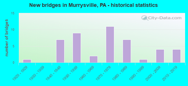
- New bridges - historical statistics
- 11920-1929
- 71940-1949
- 91950-1959
- 21960-1969
- 111970-1979
- 71980-1989
- 11990-1999
- 42000-2009
- 42010-2019
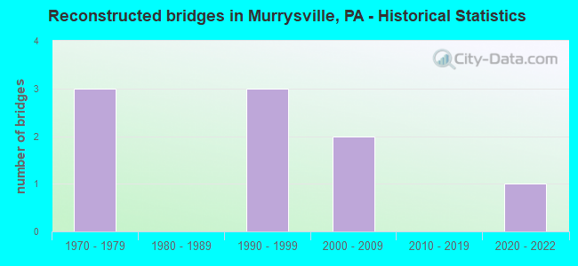
- Reconstructed bridges - Historical Statistics
- 31970-1979
- 01980-1989
- 31990-1999
- 22000-2009
- 02010-2019
- 12020-2022

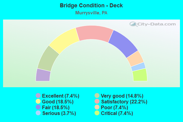
- Bridge Condition - Deck
- 7.4%Excellent
- 14.8%Very good
- 18.5%Good
- 22.2%Satisfactory
- 18.5%Fair
- 7.4%Poor
- 3.7%Serious
- 7.4%Critical
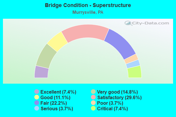
- Bridge Condition - Superstructure
- 7.4%Excellent
- 14.8%Very good
- 11.1%Good
- 29.6%Satisfactory
- 22.2%Fair
- 3.7%Poor
- 3.7%Serious
- 7.4%Critical
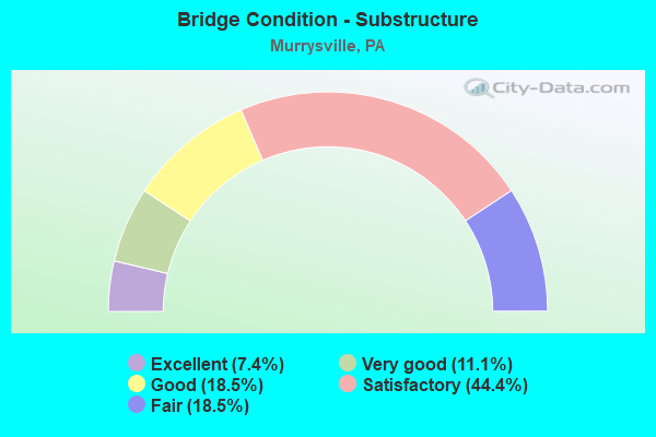
- Bridge Condition - Substructure
- 7.4%Excellent
- 11.1%Very good
- 18.5%Good
- 44.4%Satisfactory
- 18.5%Fair
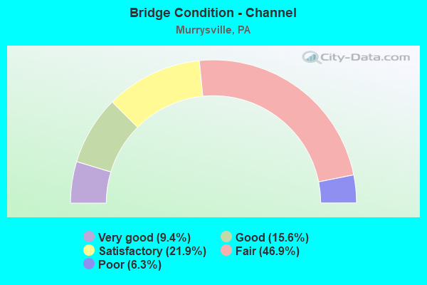
- Bridge Condition - Channel
- 9.4%Very good
- 15.6%Good
- 21.9%Satisfactory
- 46.9%Fair
- 6.3%Poor
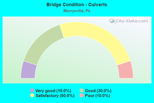
- Bridge Condition - Culverts
- 10.0%Very good
- 30.0%Good
- 50.0%Satisfactory
- 10.0%Poor
Find on map >> Show street view
Structure Number: 36185, Location: MUNICIPAL. OF MURRYSVILLE (Lat: 40.491192, Lng: -79.693206), Route carried "under" structure: State highway , Year Built: 1953, Structure Length: 0. m, Average Daily Traffic: 5,133 (year 2022), Truck Traffic: 7%, Features Intersected: SR 0286 & SR 4058, Facility Carried by Structure: SR 0286
Minimum Vertical Clearance: 4.57m (14.99ft), Kilometerpoint: 0.000, Lanes on structure: 2, Lanes under structure: 2, Material/Design: Steel continuous, Design/Construction: Stringer/Multi-beam, Length of Maximum Span: 23.5m (77.1ft)
Find on map >> Show street view
Structure Number: 36185, Location: MUNICIPAL. OF MURRYSVILLE (Lat: 40.491192, Lng: -79.693206), Route carried "under" structure: State highway 286, Year Built: 1953, Structure Length: 0. m, Average Daily Traffic: 3,192 (year 2022), Truck Traffic: 4%, Features Intersected: SR 0286 & SR 4058
Minimum Vertical Clearance: 4.57m (14.99ft), Kilometerpoint: 0.983, Lanes on structure: 2, Lanes under structure: 2, Material/Design: Steel continuous, Design/Construction: Stringer/Multi-beam, Length of Maximum Span: 23.5m (77.1ft)
Find on map >> Show street view
Structure Number: 36185, Location: MUNICIPAL. OF MURRYSVILLE (Lat: 40.491192, Lng: -79.693206), Route carried "under" structure: State highway , Year Built: 1953, Structure Length: 0. m, Average Daily Traffic: 5,039 (year 2022), Truck Traffic: 9%, Features Intersected: SR 0286 & SR 4058, Facility Carried by Structure: SR 0286
Minimum Vertical Clearance: 4.32m (14.17ft), Kilometerpoint: 0.000, Lanes on structure: 2, Lanes under structure: 2, Material/Design: Steel continuous, Design/Construction: Stringer/Multi-beam, Length of Maximum Span: 23.5m (77.1ft)
Find on map >> Show street view
Structure Number: 36185, Location: MUNICIPAL. OF MURRYSVILLE (Lat: 40.491192, Lng: -79.693206), Route carried "under" structure: State highway 286, Year Built: 1953, Structure Length: 0. m, Average Daily Traffic: 3,192 (year 2022), Truck Traffic: 4%, Features Intersected: SR 0286 & SR 4058
Minimum Vertical Clearance: 4.32m (14.17ft), Kilometerpoint: 0.983, Lanes on structure: 2, Lanes under structure: 2, Material/Design: Steel continuous, Design/Construction: Stringer/Multi-beam, Length of Maximum Span: 23.5m (77.1ft)
Find on map >> Show street view
Structure Number: 36186, Location: WASHINGTON TOWNSHIP (Lat: 40.480286, Lng: -79.592781), Route carried "under" structure: State highway 66, Year Built: 1957, Structure Length: 0. m, Average Daily Traffic: 10,265 (year 2020), Truck Traffic: 33%, Features Intersected: SR 0066, Facility Carried by Structure: SR 0286
Minimum Vertical Clearance: 8.23m (27.00ft), Kilometerpoint: 21.082, Lanes on structure: 2, Lanes under structure: 2, Material/Design: Prestressed concrete, Design/Construction: Box Beam or Girders - Single/Spread, Length of Maximum Span: 22.6m (74.1ft)
Find on map >> Show street view
Structure Number: 36203, Location: MUNICIPAL. OF MURRYSVILLE (Lat: 40.502508, Lng: -79.678361), Route carried "under" structure: State highway 380, Year Built: 1972, Structure Length: 0. m, Average Daily Traffic: 5,878 (year 2022), Truck Traffic: 7%, Features Intersected: SR 0400, TRAF. ROUTE 380, Facility Carried by Structure: SR 0366
Minimum Vertical Clearance: 4.40m (14.44ft), Kilometerpoint: 2.591, Lanes on structure: 2, Lanes under structure: 3, Material/Design: Prestressed concrete, Design/Construction: Stringer/Multi-beam, Length of Maximum Span: 30.5m (100.1ft)
Find on map >> Show street view
Structure Number: 36203, Location: MUNICIPAL. OF MURRYSVILLE (Lat: 40.502508, Lng: -79.678361), Route carried "under" structure: State highway 380, Year Built: 1972, Structure Length: 0. m, Average Daily Traffic: 6,140 (year 2022), Truck Traffic: 8%, Features Intersected: SR 0400, TRAF. ROUTE 380, Facility Carried by Structure: SR 0366
Minimum Vertical Clearance: 4.78m (15.68ft), Kilometerpoint: 2.589, Lanes on structure: 2, Lanes under structure: 2, Material/Design: Prestressed concrete, Design/Construction: Stringer/Multi-beam, Length of Maximum Span: 30.5m (100.1ft)