Bridge Statistics for New Albany, Indiana (IN)
Condition, Traffic, Stress, Structural Evaluation, Project Costs
- National Bridge Inventory (NBI) Statistics
- 119Number of bridges
- 1,184ft / 361mTotal length
- $4,840,000Total costs
- 1,836,648Total average daily traffic
- 131,127Total average daily truck traffic
- National Bridge Inventory (NBI) Registered Bridges for New Albany
- No street view available for this location
- New bridges - historical statistics
- 61920-1929
- 41930-1939
- 51940-1949
- 41950-1959
- 391960-1969
- 421970-1979
- 81980-1989
- 41990-1999
- 32000-2009
- 42010-2019
- Reconstructed bridges - Historical Statistics
- 11940-1949
- 11950-1959
- 31960-1969
- 21970-1979
- 131980-1989
- 161990-1999
- 42000-2009
- 82010-2019
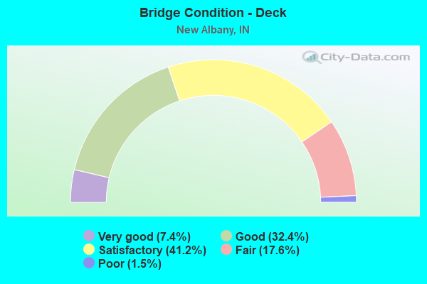
- Bridge Condition - Deck
- 7.4%Very good
- 32.4%Good
- 41.2%Satisfactory
- 17.6%Fair
- 1.5%Poor
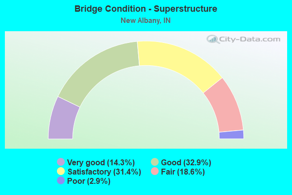
- Bridge Condition - Superstructure
- 14.3%Very good
- 32.9%Good
- 31.4%Satisfactory
- 18.6%Fair
- 2.9%Poor
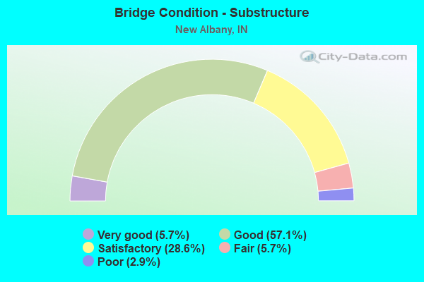
- Bridge Condition - Substructure
- 5.7%Very good
- 57.1%Good
- 28.6%Satisfactory
- 5.7%Fair
- 2.9%Poor
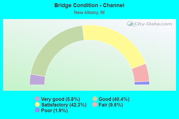
- Bridge Condition - Channel
- 5.8%Very good
- 40.4%Good
- 42.3%Satisfactory
- 9.6%Fair
- 1.9%Poor
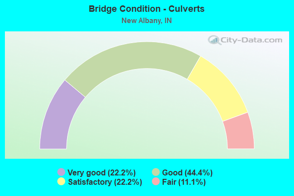
- Bridge Condition - Culverts
- 22.2%Very good
- 44.4%Good
- 22.2%Satisfactory
- 11.1%Fair
Find on map >> Show street view
Structure Number: 220011, Location: 0.15 MI. N CHARLESTOWN RD (Lat: 38.355461, Lng: -85.794431), Route carried "on" structure: City street , Year Built: 2016, Status: Open, Structure Length: 1.91m (6.27ft), Average Future Daily Traffic: 500 (year 2036), Design Load: HS 25 or greater, Features Intersected: JACOBS CREEK, Facility Carried by Structure: ENDRES PARKWAY
Minimum Vertical Clearance: 30+ m (98+ ft), Kilometerpoint: 0.000, Lanes on structure: 2, Owner: County Highway Agency, Approaching Roadway Width: 6.9m (22.6ft), Material/Design: Concrete, Design/Construction: Culvert, Number Of Spans In Main Unit: 1, Length of Maximum Span: 17.7m (58.1ft), Curb or Sidewalk Widths: Left: 0.2m (0.7ft), Right: 2.4m (7.9ft), Curb-To-Curb Width: 6.9m (22.6ft), Out-to-Out Width: 11.0m (36.1ft)
Condition: Channel: Good, Culverts: Very good, Operating Rating: 32.7 metric tons, Method Used To Determine Operating Rating: Field evaluation and documented engineering judgment, Inventory Rating: 32.7 metric tons, Method Used To Determine Inventory Rating: Field evaluation and documented engineering judgment, Structural Evaluation: Equal to present desirable criteria, Deck Geometry: Somewhat better than minimum adequacy, Waterway Adequacy: Better than present minimum criteria, Approach Roadway Alignment: Equal to present desirable criteria, Designated Inspection Frequency: Every 24 months, Inspection Date: March 2020, Wearing Surface/Protective System: Wearing Surface: Bituminous
Find on map >> Show street view
Structure Number: 2200112, Location: 00.10 S of RENN ROAD (Lat: 38.395631, Lng: -85.845450), Route carried "on" structure: Alternate County highway , Year Built: 2019, Status: Open, Structure Length: 0.76m (2.49ft), Average Daily Traffic: 244 (year 2016), Truck Traffic: 4%, Average Future Daily Traffic: 359 (year 2036), Design Load: HL 93, Features Intersected: BRANCH of BIG INDIAN CR., Facility Carried by Structure: ATKINS ROAD
Minimum Vertical Clearance: 30+ m (98+ ft), Kilometerpoint: 0.000, Lanes on structure: 2, Owner: County Highway Agency, Approaching Roadway Width: 5.8m (19.0ft), Skew: 4 degrees, Material/Design: Concrete, Design/Construction: Culvert, Number Of Spans In Main Unit: 1, Length of Maximum Span: 6.9m (22.6ft), Curb-To-Curb Width: 6.9m (22.6ft), Out-to-Out Width: 6.9m (22.6ft)
Condition: Channel: Good, Culverts: Very good, Operating Rating: 61.2 metric tons, Method Used To Determine Operating Rating: Load and Resistance Factor (LRFR), Inventory Rating: 57.9 metric tons, Method Used To Determine Inventory Rating: Load and Resistance Factor (LRFR), Structural Evaluation: Equal to present desirable criteria, Deck Geometry: Meets minimum limits, Waterway Adequacy: Equal to present desirable criteria, Approach Roadway Alignment: Equal to present minimum criteria, Designated Inspection Frequency: Every 24 months, Inspection Date: March 2020, Wearing Surface/Protective System: Wearing Surface: Bituminous
Find on map >> Show street view
Structure Number: 256, Location: 02.50 N SR-311 (Lat: 38.336250, Lng: -85.817856), Route carried "under" structure: Interstate 265, Year Built: 1972, Structure Length: 0. m, Average Daily Traffic: 27,362 (year 2004), Truck Traffic: 10%, Features Intersected: I-265 EBL, Facility Carried by Structure: SR 111X
Minimum Vertical Clearance: 5.11m (16.77ft), Kilometerpoint: 5.150, Lanes on structure: 4, Lanes under structure: 4, Material/Design: Steel continuous, Design/Construction: Stringer/Multi-beam, Length of Maximum Span: 32.7m (107.3ft)
Find on map >> Show street view
Structure Number: 256, Location: 02.50 N SR-311 (Lat: 38.336250, Lng: -85.817856), Route carried "under" structure: Interstate 265, Year Built: 1972, Structure Length: 0. m, Average Daily Traffic: 27,362 (year 2004), Truck Traffic: 10%, Features Intersected: I-265 WBL, Facility Carried by Structure: SR 111X
Minimum Vertical Clearance: 5.74m (18.83ft), Kilometerpoint: 5.150, Lanes on structure: 4, Lanes under structure: 4, Material/Design: Steel continuous, Design/Construction: Stringer/Multi-beam, Length of Maximum Span: 32.7m (107.3ft)
Find on map >> Show street view
Structure Number: 2764, Location: 08.81 E SR 335 (Lat: 38.303219, Lng: -85.890342), Route carried "under" structure: Interstate 64, Year Built: 1966, Structure Length: 0. m, Average Daily Traffic: 26,573 (year 2004), Truck Traffic: 10%, Features Intersected: I-64 EBL, Facility Carried by Structure: US 150 EB
Minimum Vertical Clearance: 6.78m (22.24ft), Kilometerpoint: 191.496, Lanes on structure: 1, Lanes under structure: 6, Material/Design: Steel continuous, Design/Construction: Stringer/Multi-beam, Length of Maximum Span: 21.0m (68.9ft)
Find on map >> Show street view
Structure Number: 2764, Location: 08.81 E SR 335 (Lat: 38.303219, Lng: -85.890342), Route carried "under" structure: Interstate 64, Year Built: 1966, Structure Length: 0. m, Average Daily Traffic: 26,573 (year 2004), Truck Traffic: 10%, Features Intersected: I-64 WBL, Facility Carried by Structure: US 150 EB
Minimum Vertical Clearance: 6.86m (22.51ft), Kilometerpoint: 191.496, Lanes on structure: 1, Lanes under structure: 6, Material/Design: Steel continuous, Design/Construction: Stringer/Multi-beam, Length of Maximum Span: 21.0m (68.9ft)
Find on map >> Show street view
Structure Number: 2765, Location: 08.81 E SR 335 (Lat: 38.303281, Lng: -85.890114), Route carried "under" structure: Interstate 64, Year Built: 1966, Structure Length: 0. m, Average Daily Traffic: 26,573 (year 2004), Truck Traffic: 10%, Features Intersected: I-64 EBL, Facility Carried by Structure: US 150 WB
Minimum Vertical Clearance: 5.69m (18.67ft), Kilometerpoint: 191.496, Lanes on structure: 1, Lanes under structure: 6, Material/Design: Steel continuous, Design/Construction: Stringer/Multi-beam, Length of Maximum Span: 21.0m (68.9ft)
Find on map >> Show street view
Structure Number: 2765, Location: 08.81 E SR 335 (Lat: 38.303281, Lng: -85.890114), Route carried "under" structure: Interstate 64, Year Built: 1966, Structure Length: 0. m, Average Daily Traffic: 26,573 (year 2004), Truck Traffic: 10%, Features Intersected: I-64 WBL, Facility Carried by Structure: US 150 WB
Minimum Vertical Clearance: 5.13m (16.83ft), Kilometerpoint: 191.496, Lanes on structure: 1, Lanes under structure: 6, Material/Design: Steel continuous, Design/Construction: Stringer/Multi-beam, Length of Maximum Span: 21.0m (68.9ft)
Find on map >> Show street view
Structure Number: 3128, Location: 03.04 S SR-60 (Lat: 38.343911, Lng: -85.798722), Route carried "under" structure: Interstate 265, Year Built: 1972, Structure Length: 0. m, Average Daily Traffic: 23,184 (year 2004), Truck Traffic: 9%, Features Intersected: I-265 EBL, Facility Carried by Structure: SR 311
Minimum Vertical Clearance: 5.56m (18.24ft), Kilometerpoint: 7.049, Lanes on structure: 5, Lanes under structure: 4, Material/Design: Steel continuous, Design/Construction: Stringer/Multi-beam, Length of Maximum Span: 34.6m (113.5ft)
Find on map >> Show street view
Structure Number: 3128, Location: 03.04 S SR-60 (Lat: 38.343911, Lng: -85.798722), Route carried "under" structure: Interstate 265, Year Built: 1972, Structure Length: 0. m, Average Daily Traffic: 23,184 (year 2004), Truck Traffic: 9%, Features Intersected: I-265 WBL, Facility Carried by Structure: SR 311
Minimum Vertical Clearance: 5.41m (17.75ft), Kilometerpoint: 7.049, Lanes on structure: 5, Lanes under structure: 4, Material/Design: Steel continuous, Design/Construction: Stringer/Multi-beam, Length of Maximum Span: 34.6m (113.5ft)
Find on map >> Show street view
Structure Number: 3439, Location: 00.73 E US 150 (Lat: 38.303481, Lng: -85.878844), Route carried "under" structure: County highway , Year Built: 1965, Structure Length: 0. m, Average Daily Traffic: 132 (year 2004), Truck Traffic: 5%, Features Intersected: QUARRY ROAD, Facility Carried by Structure: I-64 EBL
Minimum Vertical Clearance: 9.30m (30.51ft), Kilometerpoint: 0.000, Lanes on structure: 2, Lanes under structure: 2, Material/Design: Prestressed concrete, Design/Construction: Stringer/Multi-beam, Length of Maximum Span: 17.9m (58.7ft)
Find on map >> Show street view
Structure Number: 344, Location: 00.73 E US 150 (Lat: 38.303750, Lng: -85.878783), Route carried "under" structure: County highway , Year Built: 1965, Structure Length: 0. m, Average Daily Traffic: 132 (year 2004), Truck Traffic: 5%, Features Intersected: QUARRY ROAD, Facility Carried by Structure: I-64 WBL
Minimum Vertical Clearance: 6.22m (20.41ft), Kilometerpoint: 0.000, Lanes on structure: 3, Lanes under structure: 2, Material/Design: Prestressed concrete, Design/Construction: Stringer/Multi-beam, Length of Maximum Span: 14.4m (47.2ft)
Find on map >> Show street view
Structure Number: 3441, Location: 02.11 E US-150 (Lat: 38.302011, Lng: -85.851394), Route carried "under" structure: Ramp Interstate 265, Year Built: 1965, Structure Length: 0. m, Average Daily Traffic: 15,748 (year 2004), Truck Traffic: 5%, Features Intersected: I-64 WB, Facility Carried by Structure: I64 EB RAMP TO I26
Minimum Vertical Clearance: 6.86m (22.51ft), Kilometerpoint: 0.209, Lanes on structure: 3, Lanes under structure: 1, Material/Design: Steel continuous, Design/Construction: Stringer/Multi-beam, Length of Maximum Span: 21.0m (68.9ft)
Find on map >> Show street view
Structure Number: 3442, Location: 02.20 E US 150 (Lat: 38.301769, Lng: -85.850128), Route carried "under" structure: Ramp Interstate 265, Year Built: 1965, Structure Length: 0. m, Average Daily Traffic: 9,645 (year 2004), Truck Traffic: 5%, Features Intersected: I265 EB RAMP TO I64 EB, Facility Carried by Structure: I-64 WB
Minimum Vertical Clearance: 5.26m (17.26ft), Kilometerpoint: 0.209, Lanes on structure: 3, Lanes under structure: 1, Material/Design: Steel continuous, Design/Construction: Stringer/Multi-beam, Length of Maximum Span: 17.4m (57.1ft)
Find on map >> Show street view
Structure Number: 3443, Location: 00.29 E I-265 (Lat: 38.299561, Lng: -85.847000), Route carried "under" structure: County highway , Year Built: 1965, Structure Length: 0. m, Average Daily Traffic: 118 (year 2004), Truck Traffic: 5%, Features Intersected: CAPTAIN FRANK ROAD, Facility Carried by Structure: I-64 EB
Minimum Vertical Clearance: 4.95m (16.24ft), Kilometerpoint: 0.000, Lanes on structure: 3, Lanes under structure: 2, Material/Design: Prestressed concrete, Design/Construction: Stringer/Multi-beam, Length of Maximum Span: 15.1m (49.5ft)
Find on map >> Show street view
Structure Number: 3444, Location: 00.29 E I-265 (Lat: 38.300361, Lng: -85.846419), Route carried "under" structure: County highway , Year Built: 1965, Structure Length: 0. m, Average Daily Traffic: 118 (year 2004), Truck Traffic: 5%, Features Intersected: CAPTAIN FRANK ROAD, Facility Carried by Structure: I-64 WB
Minimum Vertical Clearance: 11.74m (38.52ft), Kilometerpoint: 0.000, Lanes on structure: 4, Lanes under structure: 2, Material/Design: Prestressed concrete, Design/Construction: Stringer/Multi-beam, Length of Maximum Span: 21.1m (69.2ft)
Find on map >> Show street view
Structure Number: 3445, Location: 00.85 W SR 111 (Lat: 38.290700, Lng: -85.835136), Route carried "under" structure: City street , Year Built: 1965, Structure Length: 0. m, Average Daily Traffic: 6,262 (year 2005), Truck Traffic: 5%, Features Intersected: CHERRY STREET, Facility Carried by Structure: I-64
Minimum Vertical Clearance: 4.57m (14.99ft), Kilometerpoint: 0.000, Lanes on structure: 6, Lanes under structure: 2, Material/Design: Prestressed concrete, Design/Construction: Stringer/Multi-beam, Length of Maximum Span: 25.1m (82.3ft)
Find on map >> Show street view
Structure Number: 3447, Location: 00.28 W SR-111 (Lat: 38.285369, Lng: -85.828331), Route carried "under" structure: Ramp Interstate 64, Year Built: 1960, Structure Length: 0. m, Average Daily Traffic: 18,276 (year 2004), Truck Traffic: 10%, Features Intersected: I-64 RAMP 123D TO I64 WB
Minimum Vertical Clearance: 4.40m (14.44ft), Kilometerpoint: 0.000, Lanes on structure: 2, Lanes under structure: 2, Material/Design: Concrete, Design/Construction: Stringer/Multi-beam, Length of Maximum Span: 11.4m (37.4ft)
Find on map >> Show street view
Structure Number: 3448, Location: 00.18 W SR-111 (Lat: 38.284319, Lng: -85.828086), Route carried "under" structure: Alternate State highway 62, Year Built: 1960, Structure Length: 0. m, Average Daily Traffic: 12,730 (year 2004), Truck Traffic: 5%, Features Intersected: SR-62X/SPRING STREET, Facility Carried by Structure: I-64
Minimum Vertical Clearance: 5.08m (16.67ft), Kilometerpoint: 0.097, Lanes on structure: 8, Lanes under structure: 3, Material/Design: Steel continuous, Design/Construction: Stringer/Multi-beam, Length of Maximum Span: 21.5m (70.5ft)
Find on map >> Show street view
Structure Number: 3449, Location: 00.11 W SR-111 (Lat: 38.283361, Lng: -85.827178), Route carried "under" structure: City street , Year Built: 1961, Structure Length: 0. m, Average Daily Traffic: 7,558 (year 2004), Truck Traffic: 5%, Features Intersected: MARKET STREET, Facility Carried by Structure: I-64 EB
Minimum Vertical Clearance: 6.27m (20.57ft), Kilometerpoint: 0.000, Lanes on structure: 3, Lanes under structure: 2, Material/Design: Steel continuous, Design/Construction: Stringer/Multi-beam, Length of Maximum Span: 17.2m (56.4ft)
Find on map >> Show street view
Structure Number: 345, Location: 00.11 W SR-111 (Lat: 38.283431, Lng: -85.826964), Route carried "under" structure: City street , Year Built: 1961, Structure Length: 0. m, Average Daily Traffic: 7,558 (year 2004), Truck Traffic: 5%, Features Intersected: MARKET STREET, Facility Carried by Structure: I-64 WB
Minimum Vertical Clearance: 7.42m (24.34ft), Kilometerpoint: 0.000, Lanes on structure: 3, Lanes under structure: 2, Material/Design: Steel continuous, Design/Construction: Stringer/Multi-beam, Length of Maximum Span: 17.2m (56.4ft)
Find on map >> Show street view
Structure Number: 3451, Location: 04.02 E US 150 (Lat: 38.282319, Lng: -85.826089), Route carried "under" structure: State highway 111, Year Built: 1961, Structure Length: 0. m, Average Daily Traffic: 15,444 (year 2004), Truck Traffic: 10%, Features Intersected: SR-111/MAIN STREET, Facility Carried by Structure: I-64 EB
Minimum Vertical Clearance: 5.26m (17.26ft), Kilometerpoint: 13.438, Lanes on structure: 3, Lanes under structure: 2, Material/Design: Steel continuous, Design/Construction: Stringer/Multi-beam, Length of Maximum Span: 23.9m (78.4ft)
Find on map >> Show street view
Structure Number: 34515, Location: 04.11 E US-150 (Lat: 38.282061, Lng: -85.825508), Route carried "under" structure: State highway 111, Year Built: 1961, Structure Length: 0. m, Average Daily Traffic: 14,032 (year 2004), Truck Traffic: 5%, Features Intersected: SR-111/MAIN STREET, Facility Carried by Structure: I-64 WB
Minimum Vertical Clearance: 4.75m (15.58ft), Kilometerpoint: 13.454, Lanes on structure: 3, Lanes under structure: 2, Material/Design: Steel, Design/Construction: Stringer/Multi-beam, Length of Maximum Span: 25.7m (84.3ft)
Find on map >> Show street view
Structure Number: 3452, Location: 00.11 E of SR 111 (Lat: 38.279289, Lng: -85.822875), Route carried "under" structure: City street , Year Built: 1961, Structure Length: 0. m, Average Daily Traffic: 130 (year 2009), Truck Traffic: 5%, Features Intersected: WATER STEET, Facility Carried by Structure: I-64
Minimum Vertical Clearance: 9.75m (31.99ft), Kilometerpoint: 0.000, Lanes on structure: 6, Lanes under structure: 2, Material/Design: Steel, Design/Construction: Arch - Thru, Length of Maximum Span: 243.8m (799.9ft)
Find on map >> Show street view
Structure Number: 4951, Location: 00.25 E I-64 (Lat: 38.302639, Lng: -85.850517), Route carried "under" structure: Ramp Interstate 265, Year Built: 1972, Structure Length: 0. m, Average Daily Traffic: 15,748 (year 2004), Truck Traffic: 10%, Features Intersected: I-265 RAMP B (WBL)
Minimum Vertical Clearance: 5.16m (16.93ft), Kilometerpoint: 0.483, Lanes on structure: 1, Lanes under structure: 1, Material/Design: Steel continuous, Design/Construction: Stringer/Multi-beam, Length of Maximum Span: 31.4m (103.0ft)
Find on map >> Show street view
Structure Number: 4952, Location: 00.84 E I-64 (Lat: 38.310839, Lng: -85.845664), Route carried "under" structure: City street , Year Built: 1972, Structure Length: 0. m, Average Daily Traffic: 2,500 (year 2004), Truck Traffic: 10%, Features Intersected: STATE STREET NBL, Facility Carried by Structure: I-265 EB
Minimum Vertical Clearance: 6.76m (22.18ft), Kilometerpoint: 0.000, Lanes on structure: 2, Lanes under structure: 4, Material/Design: Steel continuous, Design/Construction: Stringer/Multi-beam, Length of Maximum Span: 21.8m (71.5ft)
Find on map >> Show street view
Structure Number: 4952, Location: 00.84 E I-64 (Lat: 38.310839, Lng: -85.845664), Route carried "under" structure: City street , Year Built: 1972, Structure Length: 0. m, Average Daily Traffic: 2,500 (year 2004), Truck Traffic: 10%, Features Intersected: STATE STREET SBL, Facility Carried by Structure: I-265 EB
Minimum Vertical Clearance: 6.76m (22.18ft), Kilometerpoint: 0.000, Lanes on structure: 2, Lanes under structure: 4, Material/Design: Steel continuous, Design/Construction: Stringer/Multi-beam, Length of Maximum Span: 21.8m (71.5ft)
Find on map >> Show street view
Structure Number: 4953, Location: 00.84 E I-64 (Lat: 38.311031, Lng: -85.845878), Route carried "under" structure: City street , Year Built: 1972, Structure Length: 0. m, Average Daily Traffic: 2,500 (year 2004), Truck Traffic: 10%, Features Intersected: STATE STREET NBL, Facility Carried by Structure: I-265 WB
Minimum Vertical Clearance: 4.60m (15.09ft), Kilometerpoint: 0.000, Lanes on structure: 3, Lanes under structure: 4, Material/Design: Steel continuous, Design/Construction: Stringer/Multi-beam, Length of Maximum Span: 21.1m (69.2ft)
Find on map >> Show street view
Structure Number: 4953, Location: 00.84 E I-64 (Lat: 38.311031, Lng: -85.845878), Route carried "under" structure: City street , Year Built: 1972, Structure Length: 0. m, Average Daily Traffic: 2,500 (year 2004), Truck Traffic: 10%, Features Intersected: STATE STREET SBL, Facility Carried by Structure: I-265 WB
Minimum Vertical Clearance: 4.60m (15.09ft), Kilometerpoint: 0.000, Lanes on structure: 3, Lanes under structure: 4, Material/Design: Steel continuous, Design/Construction: Stringer/Multi-beam, Length of Maximum Span: 21.1m (69.2ft)
Find on map >> Show street view
Structure Number: 49535, Location: 00.84 E I-64 (Lat: 38.310781, Lng: -85.845567), Route carried "under" structure: City street , Year Built: 1983, Structure Length: 0. m, Average Daily Traffic: 2,500 (year 2004), Truck Traffic: 10%, Features Intersected: STATE STREET SBL, Facility Carried by Structure: I-265 RAMP C (EB)
Minimum Vertical Clearance: 7.80m (25.59ft), Kilometerpoint: 0.000, Lanes on structure: 1, Lanes under structure: 4, Material/Design: Steel continuous, Design/Construction: Stringer/Multi-beam, Length of Maximum Span: 21.4m (70.2ft)
Find on map >> Show street view
Structure Number: 49535, Location: 00.84 E I-64 (Lat: 38.310781, Lng: -85.845567), Route carried "under" structure: City street , Year Built: 1983, Structure Length: 0. m, Average Daily Traffic: 2,500 (year 2004), Truck Traffic: 10%, Features Intersected: STATE STREET NBL, Facility Carried by Structure: I-265 RAMP C (EB)
Minimum Vertical Clearance: 7.80m (25.59ft), Kilometerpoint: 0.000, Lanes on structure: 1, Lanes under structure: 4, Material/Design: Steel continuous, Design/Construction: Stringer/Multi-beam, Length of Maximum Span: 21.4m (70.2ft)
Find on map >> Show street view
Structure Number: 4954, Location: 01.29 W SR-111 (Lat: 38.324561, Lng: -85.836533), Route carried "under" structure: Interstate 265, Year Built: 1972, Structure Length: 0. m, Average Daily Traffic: 27,363 (year 2004), Truck Traffic: 7%, Features Intersected: I-265 WBL, Facility Carried by Structure: GREEN VALLEY ROAD
Minimum Vertical Clearance: 5.23m (17.16ft), Kilometerpoint: 3.074, Lanes on structure: 2, Lanes under structure: 4, Material/Design: Steel continuous, Design/Construction: Stringer/Multi-beam, Length of Maximum Span: 35.1m (115.2ft)
Find on map >> Show street view
Structure Number: 4954, Location: 01.29 W SR-111 (Lat: 38.324561, Lng: -85.836533), Route carried "under" structure: Interstate 265, Year Built: 1972, Structure Length: 0. m, Average Daily Traffic: 27,363 (year 2004), Truck Traffic: 7%, Features Intersected: I-265 EBL, Facility Carried by Structure: GREEN VALLEY ROAD
Minimum Vertical Clearance: 5.03m (16.50ft), Kilometerpoint: 3.074, Lanes on structure: 2, Lanes under structure: 4, Material/Design: Steel continuous, Design/Construction: Stringer/Multi-beam, Length of Maximum Span: 35.1m (115.2ft)
Find on map >> Show street view
Structure Number: 4955, Location: 00.50 W SR-111 (Lat: 38.332111, Lng: -85.825242), Route carried "under" structure: County highway , Year Built: 1972, Structure Length: 0. m, Average Daily Traffic: 8,752 (year 2004), Truck Traffic: 7%, Features Intersected: MOUNT TABOR ROAD, Facility Carried by Structure: I-265 EB
Minimum Vertical Clearance: 4.27m (14.01ft), Kilometerpoint: 0.000, Lanes on structure: 2, Lanes under structure: 2, Material/Design: Steel continuous, Design/Construction: Stringer/Multi-beam, Length of Maximum Span: 18.6m (61.0ft)
Find on map >> Show street view
Structure Number: 4956, Location: 00.50 W SR-111 (Lat: 38.332119, Lng: -85.825675), Route carried "under" structure: County highway , Year Built: 1972, Structure Length: 0. m, Average Daily Traffic: 8,752 (year 2004), Truck Traffic: 7%, Features Intersected: MOUNT TABOR ROAD, Facility Carried by Structure: I-265 WB
Minimum Vertical Clearance: 4.65m (15.26ft), Kilometerpoint: 0.000, Lanes on structure: 2, Lanes under structure: 2, Material/Design: Steel continuous, Design/Construction: Stringer/Multi-beam, Length of Maximum Span: 18.6m (61.0ft)
Find on map >> Show street view
Structure Number: 49585, Location: 00.40 E SR-111 (Lat: 38.339281, Lng: -85.811553), Route carried "under" structure: Interstate 265, Year Built: 1979, Structure Length: 0. m, Average Daily Traffic: 27,676 (year 2004), Truck Traffic: 7%, Features Intersected: I-265 EBL, Facility Carried by Structure: KLERNER LANE
Minimum Vertical Clearance: 5.03m (16.50ft), Kilometerpoint: 5.794, Lanes on structure: 2, Lanes under structure: 5, Material/Design: Steel continuous, Design/Construction: Stringer/Multi-beam, Length of Maximum Span: 37.8m (124.0ft)
Find on map >> Show street view
Structure Number: 49585, Location: 00.40 E SR-111 (Lat: 38.339281, Lng: -85.811553), Route carried "under" structure: Interstate 265, Year Built: 1979, Structure Length: 0. m, Average Daily Traffic: 27,676 (year 2004), Truck Traffic: 7%, Features Intersected: I-265 WBL, Facility Carried by Structure: KLERNER LANE
Minimum Vertical Clearance: 4.88m (16.01ft), Kilometerpoint: 5.794, Lanes on structure: 2, Lanes under structure: 5, Material/Design: Steel continuous, Design/Construction: Stringer/Multi-beam, Length of Maximum Span: 37.8m (124.0ft)
Find on map >> Show street view
Structure Number: 4959, Location: 00.43 E SR-311 (Lat: 38.344539, Lng: -85.790756), Route carried "under" structure: Interstate 265, Year Built: 1972, Structure Length: 0. m, Average Daily Traffic: 23,184 (year 2004), Truck Traffic: 5%, Features Intersected: I-265 WBL, Facility Carried by Structure: PAYNE-KOEHLER ROAD
Minimum Vertical Clearance: 5.21m (17.09ft), Kilometerpoint: 7.741, Lanes on structure: 2, Lanes under structure: 4, Material/Design: Steel continuous, Design/Construction: Stringer/Multi-beam, Length of Maximum Span: 37.2m (122.0ft)
Find on map >> Show street view
Structure Number: 4959, Location: 00.43 E SR-311 (Lat: 38.344539, Lng: -85.790756), Route carried "under" structure: Interstate 265, Year Built: 1972, Structure Length: 0. m, Average Daily Traffic: 23,184 (year 2004), Truck Traffic: 5%, Features Intersected: I-265 EBL, Facility Carried by Structure: PAYNE-KOEHLER ROAD
Minimum Vertical Clearance: 5.39m (17.68ft), Kilometerpoint: 7.741, Lanes on structure: 2, Lanes under structure: 4, Material/Design: Steel continuous, Design/Construction: Stringer/Multi-beam, Length of Maximum Span: 37.2m (122.0ft)
Find on map >> Show street view
Structure Number: 4962, Location: 00.89 W I-65 (Lat: 38.345269, Lng: -85.768867), Route carried "under" structure: ServiceCity street , Year Built: 1972, Structure Length: 0. m, Average Daily Traffic: 1 (year 2004), Truck Traffic: 50%, Features Intersected: ADMORE LANE, Facility Carried by Structure: I-265 EB
Minimum Vertical Clearance: 4.57m (14.99ft), Kilometerpoint: 0.000, Lanes on structure: 2, Lanes under structure: 1, Material/Design: Steel continuous, Design/Construction: Stringer/Multi-beam, Length of Maximum Span: 27.9m (91.5ft)
Find on map >> Show street view
Structure Number: 4963, Location: 00.89 W I-65 (Lat: 38.345500, Lng: -85.768744), Route carried "under" structure: ServiceCity street , Year Built: 1972, Structure Length: 0. m, Average Daily Traffic: 1 (year 2004), Truck Traffic: 50%, Features Intersected: ACCESS ROAD, Facility Carried by Structure: I-265 WB
Minimum Vertical Clearance: 4.57m (14.99ft), Kilometerpoint: 0.000, Lanes on structure: 2, Lanes under structure: 1, Material/Design: Steel continuous, Design/Construction: Stringer/Multi-beam, Length of Maximum Span: 27.9m (91.5ft)
Find on map >> Show street view
Structure Number: 1000145, Location: 00.58 W SR 131 (Lat: 38.300519, Lng: -85.791747), Route carried "under" structure: Ramp County highway , Year Built: 1959, Structure Length: 0. m, Average Daily Traffic: 3,781 (year 2012), Truck Traffic: 5%, Features Intersected: SPRING ST TO PROVIDENCE, Facility Carried by Structure: BROWNS STATION WAY
Minimum Vertical Clearance: 4.55m (14.93ft), Kilometerpoint: 0.000, Lanes on structure: 4, Lanes under structure: 2, Material/Design: Steel continuous, Design/Construction: Stringer/Multi-beam, Length of Maximum Span: 21.9m (71.9ft)