Bridge Statistics for New Haven, Connecticut (CT)
Condition, Traffic, Stress, Structural Evaluation, Project Costs
- National Bridge Inventory (NBI) Statistics
- 179Number of bridges
- 3,461ft / 1,055mTotal length
- $136,065,000Total costs
- 5,621,098Total average daily traffic
- 529,194Total average daily truck traffic
- National Bridge Inventory (NBI) Registered Bridges for New Haven
- No street view available for this location
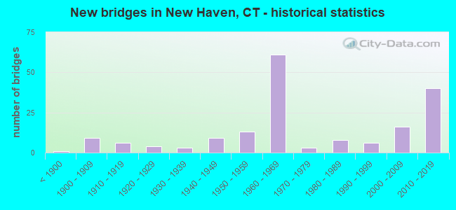
- New bridges - historical statistics
- 1Before 1900
- 91900-1909
- 61910-1919
- 41920-1929
- 31930-1939
- 91940-1949
- 131950-1959
- 611960-1969
- 31970-1979
- 81980-1989
- 61990-1999
- 162000-2009
- 402010-2019

- Reconstructed bridges - Historical Statistics
- 31960-1969
- 11970-1979
- 121980-1989
- 71990-1999
- 102000-2009
- 82010-2019


- Bridge Condition - Deck
- 5.7%Very good
- 54.7%Good
- 34.0%Satisfactory
- 5.7%Fair

- Bridge Condition - Superstructure
- 4.4%Very good
- 37.7%Good
- 42.1%Satisfactory
- 14.9%Fair
- 0.9%Serious

- Bridge Condition - Substructure
- 1.8%Very good
- 45.6%Good
- 39.5%Satisfactory
- 11.4%Fair
- 1.8%Poor

- Bridge Condition - Channel
- 4.7%Very good
- 20.9%Good
- 55.8%Satisfactory
- 14.0%Fair
- 4.7%Poor

- Bridge Condition - Culverts
- 22.2%Good
- 33.3%Satisfactory
- 44.4%Fair
Find on map >> Show street view
Structure Number: 16, Location: .7 MI EAST OF MIANUS RV (Lat: 41.038622, Lng: -73.586811), Route carried "on" structure: City street , Year Built: 1958, Status: Open, Structure Length: 5.58m (18.31ft), Average Daily Traffic: 9,500 (year 2011), Truck Traffic: 3%, Average Future Daily Traffic: 14,116 (year 2031), Design Load: HS 20, Features Intersected: INTERSTATE-95, Facility Carried by Structure: RIVERSIDE AVENUE
Minimum Vertical Clearance: 30+ m (98+ ft), Kilometerpoint: 0.241, Lanes on structure: 2, Lanes under structure: 6, Owner: State Highway Agency, Approaching Roadway Width: 12.2m (40.0ft), Skew: 4 degrees, Material/Design: Steel continuous, Design/Construction: Stringer/Multi-beam, Number Of Spans In Main Unit: 2, Length of Maximum Span: 27.0m (88.6ft), Curb or Sidewalk Widths: Left: 3.0m (9.8ft), Right: 3.0m (9.8ft), Curb-To-Curb Width: 12.2m (40.0ft), Out-to-Out Width: 19.1m (62.7ft)
Condition: Deck: Satisfactory, Superstructure: Satisfactory, Substructure: Satisfactory, Operating Rating: 52.6 metric tons, Method Used To Determine Operating Rating: Load Factor (LF), Inventory Rating: 31.7 metric tons, Method Used To Determine Inventory Rating: Load Factor (LF), Structural Evaluation: Equal to present minimum criteria, Deck Geometry: Somewhat better than minimum adequacy, Underclear: Equal to present minimum criteria, Approach Roadway Alignment: Equal to present minimum criteria, Designated Inspection Frequency: Every 24 months, Inspection Date: October 2020, Deck Structure Type: Concrete Cast-file-Place, Wearing Surface/Protective System: Wearing Surface: Bituminous, Membrane: Preformed Fabric
Find on map >> Show street view
Structure Number: 157, Location: I-95 AT EXIT 42 (Lat: 41.273269, Lng: -72.970250), Route carried "on" structure: Interstate 95, Year Built: 2005, Status: Open, Structure Length: 4.92m (16.14ft), Average Daily Traffic: 105,200 (year 2021), Truck Traffic: 9%, Average Future Daily Traffic: 156,317 (year 2041), Design Load: HS 20, Features Intersected: ROUTE 162
Minimum Vertical Clearance: 30+ m (98+ ft), Kilometerpoint: 70.666, Lanes on structure: 7, Lanes under structure: 5, Base Highway Network: Yes, Owner: State Highway Agency, Approaching Roadway Width: 38.7m (127.0ft), Skew: 35 degrees, Material/Design: Steel, Design/Construction: Stringer/Multi-beam, Number Of Spans In Main Unit: 1, Length of Maximum Span: 46.2m (151.6ft), Curb-To-Curb Width: 38.8m (127.3ft), Out-to-Out Width: 41.7m (136.8ft)
Condition: Deck: Good, Superstructure: Good, Substructure: Good, Operating Rating: 97.4 metric tons, Method Used To Determine Operating Rating: Load Factor (LF), Inventory Rating: 58.4 metric tons, Method Used To Determine Inventory Rating: Load Factor (LF), Structural Evaluation: Better than present minimum criteria, Deck Geometry: Superior to present desirable criteria, Underclear: Equal to present minimum criteria, Approach Roadway Alignment: Equal to present desirable criteria, Designated Inspection Frequency: Every 24 months, Inspection Date: October 2021, Deck Structure Type: Concrete Cast-file-Place, Wearing Surface/Protective System: Wearing Surface: Bituminous, Membrane: Built-up, Deck Protection: Epoxy Coated Reinforcing
Find on map >> Show street view
Structure Number: 158, Location: 0.2 MI N OF ROUTE 162 (Lat: 41.275922, Lng: -72.968303), Route carried "on" structure: Interstate 95, Year Built: 1957, Status: Open, Structure Length: 1.68m (5.51ft), Average Daily Traffic: 114,100 (year 2020), Truck Traffic: 9%, Average Future Daily Traffic: 169,541 (year 2040), Design Load: H 20, Features Intersected: GRETA STREET
Minimum Vertical Clearance: 30+ m (98+ ft), Kilometerpoint: 71.036, Lanes on structure: 7, Lanes under structure: 2, Base Highway Network: Yes, Owner: State Highway Agency, Approaching Roadway Width: 30.5m (100.1ft), Skew: 32 degrees, Material/Design: Steel, Design/Construction: Stringer/Multi-beam, Number Of Spans In Main Unit: 1, Length of Maximum Span: 15.2m (49.9ft), Curb-To-Curb Width: 40.8m (133.9ft), Out-to-Out Width: 42.6m (139.8ft)
Condition: Deck: Satisfactory, Superstructure: Satisfactory, Substructure: Satisfactory, Operating Rating: 39.2 metric tons, Method Used To Determine Operating Rating: Load and Resistance Factor Rating (LRFR) rating reported by rating factor(RF) method using HL-93 loadings, Inventory Rating: 30.1 metric tons, Method Used To Determine Inventory Rating: Load and Resistance Factor Rating (LRFR) rating reported by rating factor(RF) method using HL-93 loadings, Structural Evaluation: Equal to present minimum criteria, Deck Geometry: Superior to present desirable criteria, Underclear: Somewhat better than minimum adequacy, Approach Roadway Alignment: Equal to present desirable criteria, Designated Inspection Frequency: Every 24 months, Inspection Date: January 2022, Deck Structure Type: Concrete Cast-file-Place, Wearing Surface/Protective System: Wearing Surface: Bituminous, Membrane: Preformed Fabric
Find on map >> Show street view
Structure Number: 159, Location: 0.7 MI N OF ROUTE 162 (Lat: 41.279417, Lng: -72.961111), Route carried "on" structure: City street , Year Built: 1957, Year Reconstructed: 2002, Status: Open, Structure Length: 3.78m (12.40ft), Average Daily Traffic: 4,634 (year 2021), Truck Traffic: 4%, Average Future Daily Traffic: 6,886 (year 2041), Design Load: HS 20, Features Intersected: INTERSTATE 95, Facility Carried by Structure: STEVENS AVENUE
Minimum Vertical Clearance: 30+ m (98+ ft), Kilometerpoint: 0.322, Lanes on structure: 2, Lanes under structure: 6, Owner: State Highway Agency, Approaching Roadway Width: 10.7m (35.1ft), Material/Design: Steel continuous, Design/Construction: Stringer/Multi-beam, Number Of Spans In Main Unit: 2, Length of Maximum Span: 18.3m (60.0ft), Curb or Sidewalk Widths: Left: 1.6m (5.2ft), Right: 1.6m (5.2ft), Curb-To-Curb Width: 10.6m (34.8ft), Out-to-Out Width: 14.5m (47.6ft)
Condition: Deck: Good, Superstructure: Good, Substructure: Satisfactory, Operating Rating: 58.6 metric tons, Method Used To Determine Operating Rating: Load and Resistance Factor Rating (LRFR) rating reported by rating factor(RF) method using HL-93 loadings, Inventory Rating: 45.4 metric tons, Method Used To Determine Inventory Rating: Load and Resistance Factor Rating (LRFR) rating reported by rating factor(RF) method using HL-93 loadings, Structural Evaluation: Equal to present minimum criteria, Deck Geometry: Somewhat better than minimum adequacy, Underclear: High priority of corrective action, Approach Roadway Alignment: Better than present minimum criteria, Designated Inspection Frequency: Every 24 months, Inspection Date: January 2021, Deck Structure Type: Concrete Cast-file-Place, Wearing Surface/Protective System: Wearing Surface: Bituminous, Membrane: Built-up, Deck Protection: Epoxy Coated Reinforcing
Find on map >> Show street view
Structure Number: 163A, Location: 0.5 MI S OF RT 10 (Lat: 41.283572, Lng: -72.939208), Route carried "on" structure: Interstate 95, Year Built: 2018, Status: Open, Structure Length: 31.47m (103.25ft), Average Daily Traffic: 137,300 (year 2017), Truck Traffic: 14%, Average Future Daily Traffic: 204,014 (year 2037), Design Load: HL 93, Features Intersected: WEST RIVER & SR 745
Minimum Vertical Clearance: 30+ m (98+ ft), Kilometerpoint: 73.547, Lanes on structure: 6, Lanes under structure: 6, Base Highway Network: Yes, Owner: State Highway Agency, Approaching Roadway Width: 23.6m (77.4ft), Skew: 32 degrees, Material/Design: Steel, Design/Construction: Stringer/Multi-beam, Number Of Spans In Main Unit: 12, Length of Maximum Span: 62.0m (203.4ft), Curb or Sidewalk Widths: Left: 0.0m, Right: 0.1m (0.3ft), Curb-To-Curb Width: 23.6m (77.4ft), Out-to-Out Width: 44.3m (145.3ft)
Condition: Deck: Good, Superstructure: Good, Substructure: Good, Channel: Very good, Operating Rating: 59.6 metric tons, Method Used To Determine Operating Rating: Load and Resistance Factor Rating (LRFR) rating reported by rating factor(RF) method using HL-93 loadings, Inventory Rating: 34.0 metric tons, Method Used To Determine Inventory Rating: Load and Resistance Factor Rating (LRFR) rating reported by rating factor(RF) method using HL-93 loadings, Structural Evaluation: Better than present minimum criteria, Deck Geometry: High priority of corrective action, Underclear: Equal to present minimum criteria, Waterway Adequacy: Superior to present desirable criteria, Approach Roadway Alignment: Equal to present minimum criteria, Designated Inspection Frequency: Every 24 months, Underwater Inspection Frequency: Every 48 months, Inspection Date: September 2020, Underwater Inspection Date: June 2018, Total Project Cost: $47,332,000, Deck Structure Type: Concrete Cast-file-Place, Wearing Surface/Protective System: Wearing Surface: Bituminous
Find on map >> Show street view
Structure Number: 164, Location: 1.5 MILES SOUTH OF I-91 (Lat: 41.283975, Lng: -72.934553), Route carried "on" structure: Interstate 95, Year Built: 1957, Year Reconstructed: 2015, Status: Open, Structure Length: 3.43m (11.25ft), Average Daily Traffic: 128,000 (year 2017), Truck Traffic: 9%, Average Future Daily Traffic: 190,195 (year 2037), Design Load: HL 93, Features Intersected: ROUTE 10
Minimum Vertical Clearance: 30+ m (98+ ft), Kilometerpoint: 74.110, Lanes on structure: 6, Lanes under structure: 2, Base Highway Network: Yes, Owner: State Highway Agency, Approaching Roadway Width: 38.4m (126.0ft), Skew: 30 degrees, Material/Design: Steel, Design/Construction: Stringer/Multi-beam, Number Of Spans In Main Unit: 1, Length of Maximum Span: 32.1m (105.3ft), Curb-To-Curb Width: 38.4m (126.0ft), Out-to-Out Width: 41.3m (135.5ft)
Condition: Deck: Good, Superstructure: Very good, Substructure: Good, Operating Rating: 60.6 metric tons, Method Used To Determine Operating Rating: Load and Resistance Factor Rating (LRFR) rating reported by rating factor(RF) method using HL-93 loadings, Inventory Rating: 46.3 metric tons, Method Used To Determine Inventory Rating: Load and Resistance Factor Rating (LRFR) rating reported by rating factor(RF) method using HL-93 loadings, Structural Evaluation: Better than present minimum criteria, Deck Geometry: Superior to present desirable criteria, Underclear: Equal to present minimum criteria, Approach Roadway Alignment: Equal to present desirable criteria, Designated Inspection Frequency: Every 24 months, Inspection Date: September 2020, Total Project Cost: $47,332,000, Deck Structure Type: Concrete Cast-file-Place, Wearing Surface/Protective System: Wearing Surface: Bituminous, Membrane: Other
Find on map >> Show street view
Structure Number: 165, Location: 0.2 MI N OF ROUTE 10 (Lat: 41.284633, Lng: -72.930561), Route carried "on" structure: City street , Year Built: 2010, Status: Open, Structure Length: 5.00m (16.40ft), Average Daily Traffic: 4,002 (year 2021), Truck Traffic: 5%, Average Future Daily Traffic: 5,947 (year 2041), Design Load: HL 93, Features Intersected: INTERSTATE-95, Facility Carried by Structure: HOWARD AVENUE
Minimum Vertical Clearance: 30+ m (98+ ft), Kilometerpoint: 0.306, Lanes on structure: 2, Lanes under structure: 8, Owner: State Highway Agency, Approaching Roadway Width: 16.8m (55.1ft), Material/Design: Steel continuous, Design/Construction: Stringer/Multi-beam, Number Of Spans In Main Unit: 2, Length of Maximum Span: 24.1m (79.1ft), Curb or Sidewalk Widths: Left: 3.5m (11.5ft), Right: 3.5m (11.5ft), Curb-To-Curb Width: 16.8m (55.1ft), Out-to-Out Width: 24.5m (80.4ft)
Condition: Deck: Good, Superstructure: Good, Substructure: Good, Operating Rating: 71.9 metric tons, Method Used To Determine Operating Rating: Load and Resistance Factor Rating (LRFR) rating reported by rating factor(RF) method using HL-93 loadings, Inventory Rating: 55.4 metric tons, Method Used To Determine Inventory Rating: Load and Resistance Factor Rating (LRFR) rating reported by rating factor(RF) method using HL-93 loadings, Structural Evaluation: Better than present minimum criteria, Deck Geometry: Superior to present desirable criteria, Underclear: High priority of corrective action, Approach Roadway Alignment: Equal to present desirable criteria, Designated Inspection Frequency: Every 24 months, Inspection Date: June 2021, Deck Structure Type: Concrete Cast-file-Place, Wearing Surface/Protective System: Wearing Surface: Bituminous, Membrane: Built-up, Deck Protection: Epoxy Coated Reinforcing
Find on map >> Show street view
Structure Number: 172, Location: OVER WATER STREET (Lat: 41.299019, Lng: -72.915708), Route carried "on" structure: Interstate 95, Year Built: 2013, Status: Open, Structure Length: 42.18m (138.39ft), Average Daily Traffic: 61,300 (year 2017), Truck Traffic: 9%, Average Future Daily Traffic: 91,086 (year 2037), Design Load: HS 20, Features Intersected: I-91NB,US1,RTE 34 & RAMP
Minimum Vertical Clearance: 7.62m (25.00ft), Kilometerpoint: 76.798, Lanes on structure: 6, Lanes under structure: 15, Base Highway Network: Yes, Owner: State Highway Agency, Approaching Roadway Width: 36.0m (118.1ft), Skew: 10 degrees, Material/Design: Steel continuous, Design/Construction: Stringer/Multi-beam, Number Of Spans In Main Unit: 7, Length of Maximum Span: 76.0m (249.3ft), Curb-To-Curb Width: 36.0m (118.1ft), Out-to-Out Width: 38.9m (127.6ft)
Condition: Deck: Good, Superstructure: Good, Substructure: Good, Operating Rating: 59.9 metric tons, Method Used To Determine Operating Rating: Load Factor (LF), Inventory Rating: 35.4 metric tons, Method Used To Determine Inventory Rating: Load Factor (LF), Structural Evaluation: Better than present minimum criteria, Deck Geometry: Superior to present desirable criteria, Underclear: High priority of corrective action, Approach Roadway Alignment: Equal to present desirable criteria, Designated Inspection Frequency: Every 24 months, Inspection Date: June 2021, Deck Structure Type: Concrete Cast-file-Place, Wearing Surface/Protective System: Wearing Surface: Bituminous, Membrane: Preformed Fabric, Deck Protection: Epoxy Coated Reinforcing
Find on map >> Show street view
Structure Number: 174A, Location: OVER QUINNIPIAC RIVER (Lat: 41.301856, Lng: -72.910983), Route carried "on" structure: Interstate 95, Year Built: 2014, Status: Open, Structure Length: 141.55m (464.40ft), Average Daily Traffic: 73,300 (year 2017), Truck Traffic: 9%, Average Future Daily Traffic: 108,916 (year 2037), Design Load: HS 20, Features Intersected: US1,QUINNIPIAC RV,P&W RR
Minimum Vertical Clearance: 7.62m (25.00ft), Kilometerpoint: 76.283, Lanes on structure: 3, Lanes under structure: 8, Base Highway Network: Yes, Owner: State Highway Agency, Approaching Roadway Width: 18.0m (59.1ft), Skew: 9 degrees, Navigation Control: Yes ( Vertical Clearance: 19.5m (64.0ft), Horizontal Clearance: 70.1m (230.0ft)), Material/Design: Prestressed concrete continuous, Design/Construction: Stayed Girder, Number Of Spans In Main Unit: 3, Number Of Approach Spans: 20, Length of Maximum Span: 157.0m (515.1ft), Curb-To-Curb Width: 18.0m (59.1ft), Out-to-Out Width: 19.1m (62.7ft)
Condition: Deck: Good, Superstructure: Satisfactory, Substructure: Good, Channel: Good, Operating Rating: 55.1 metric tons, Method Used To Determine Operating Rating: Load Factor (LF), Inventory Rating: 32.9 metric tons, Method Used To Determine Inventory Rating: Load Factor (LF), Structural Evaluation: Equal to present minimum criteria, Deck Geometry: Better than present minimum criteria, Underclear: High priority of corrective action, Waterway Adequacy: Equal to present desirable criteria, Approach Roadway Alignment: Equal to present desirable criteria, Designated Inspection Frequency: Every 24 months, Underwater Inspection Frequency: Every 24 months, Inspection Date: May 2019, Underwater Inspection Date: May 2019, Total Project Cost: $3,000,000 ( Estimate for 2020), Deck Structure Type: Concrete Cast-file-Place, Wearing Surface/Protective System: Wearing Surface: Latex Concrete, Membrane: Other, Deck Protection: Epoxy Coated Reinforcing
Find on map >> Show street view
Structure Number: 174B, Location: OVER QUINNIPIAC RIVER (Lat: 41.301933, Lng: -72.910969), Route carried "on" structure: Interstate 95, Year Built: 2015, Status: Open, Structure Length: 140.15m (459.81ft), Average Daily Traffic: 73,300 (year 2017), Truck Traffic: 9%, Average Future Daily Traffic: 108,916 (year 2037), Design Load: HS 20, Features Intersected: US1,QUINNIPIAC RV,P&W RR
Minimum Vertical Clearance: 6.35m (20.83ft), Kilometerpoint: 76.927, Lanes on structure: 3, Lanes under structure: 8, Base Highway Network: Yes, Owner: State Highway Agency, Approaching Roadway Width: 18.0m (59.1ft), Skew: 9 degrees, Navigation Control: Yes ( Vertical Clearance: 18.3m (60.0ft), Horizontal Clearance: 86.3m (283.1ft)), Material/Design: Prestressed concrete continuous, Design/Construction: Stayed Girder, Number Of Spans In Main Unit: 3, Number Of Approach Spans: 20, Length of Maximum Span: 157.0m (515.1ft), Curb-To-Curb Width: 18.0m (59.1ft), Out-to-Out Width: 19.1m (62.7ft)
Condition: Deck: Good, Superstructure: Satisfactory, Substructure: Good, Channel: Good, Operating Rating: 55.8 metric tons, Method Used To Determine Operating Rating: Load Factor (LF), Inventory Rating: 33.3 metric tons, Method Used To Determine Inventory Rating: Load Factor (LF), Structural Evaluation: Equal to present minimum criteria, Deck Geometry: Better than present minimum criteria, Underclear: Equal to present minimum criteria, Waterway Adequacy: Equal to present desirable criteria, Approach Roadway Alignment: Somewhat better than minimum adequacy, Designated Inspection Frequency: Every 24 months, Underwater Inspection Frequency: Every 24 months, Inspection Date: May 2019, Underwater Inspection Date: May 2019, Total Project Cost: $3,000,000 ( Estimate for 2020), Deck Structure Type: Concrete Cast-file-Place, Wearing Surface/Protective System: Wearing Surface: Latex Concrete, Membrane: Other, Deck Protection: Epoxy Coated Reinforcing
Find on map >> Show street view
Structure Number: 174C, Location: AT WEST END OF Q-BRIDGE (Lat: 41.300250, Lng: -72.913278), Route carried "on" structure: Ramp State highway 34, Year Built: 2011, Status: Open, Structure Length: 44.68m (146.59ft), Average Daily Traffic: 26,700 (year 2017), Truck Traffic: 6%, Average Future Daily Traffic: 39,674 (year 2037), Design Load: HS 20, Features Intersected: US1, Local Rds, P&W RR
Minimum Vertical Clearance: 30+ m (98+ ft), Kilometerpoint: 38.866, Lanes on structure: 1, Lanes under structure: 11, Owner: State Highway Agency, Approaching Roadway Width: 9.0m (29.5ft), Skew: 2 degrees, Material/Design: Steel continuous, Design/Construction: Stringer/Multi-beam, Number Of Spans In Main Unit: 10, Length of Maximum Span: 62.5m (205.1ft), Curb-To-Curb Width: 9.0m (29.5ft), Out-to-Out Width: 10.1m (33.1ft)
Condition: Deck: Good, Superstructure: Good, Substructure: Good, Operating Rating: 60.7 metric tons, Method Used To Determine Operating Rating: Load Factor (LF), Inventory Rating: 36.2 metric tons, Method Used To Determine Inventory Rating: Load Factor (LF), Structural Evaluation: Better than present minimum criteria, Deck Geometry: Superior to present desirable criteria, Underclear: Equal to present minimum criteria, Approach Roadway Alignment: Equal to present desirable criteria, Designated Inspection Frequency: Every 24 months, Inspection Date: January 2021, Deck Structure Type: Concrete Cast-file-Place, Wearing Surface/Protective System: Wearing Surface: Latex Concrete, Membrane: Built-up
Find on map >> Show street view
Structure Number: 174D, Location: AT WEST END OF Q-BRIDGE (Lat: 41.301361, Lng: -72.910861), Route carried "on" structure: Ramp Interstate 95, Year Built: 1958, Year Reconstructed: 2011, Status: Open, Structure Length: 14.78m (48.49ft), Average Daily Traffic: 20,300 (year 2018), Truck Traffic: 9%, Average Future Daily Traffic: 30,164 (year 2038), Design Load: HS 20, Features Intersected: EAST STREET & PWRR
Minimum Vertical Clearance: 30+ m (98+ ft), Kilometerpoint: 0.016, Lanes on structure: 2, Lanes under structure: 4, Owner: State Highway Agency, Approaching Roadway Width: 14.1m (46.3ft), Skew: 1 degrees, Material/Design: Steel continuous, Design/Construction: Stringer/Multi-beam, Number Of Spans In Main Unit: 3, Length of Maximum Span: 55.5m (182.1ft), Curb-To-Curb Width: 14.1m (46.3ft), Out-to-Out Width: 15.2m (49.9ft)
Condition: Deck: Good, Superstructure: Good, Substructure: Good, Operating Rating: 65.3 metric tons, Method Used To Determine Operating Rating: Load Factor (LF), Inventory Rating: 39.2 metric tons, Method Used To Determine Inventory Rating: Load Factor (LF), Structural Evaluation: Better than present minimum criteria, Deck Geometry: Superior to present desirable criteria, Underclear: Superior to present desirable criteria, Approach Roadway Alignment: Equal to present desirable criteria, Designated Inspection Frequency: Every 24 months, Inspection Date: May 2021, Deck Structure Type: Concrete Cast-file-Place, Wearing Surface/Protective System: Wearing Surface: Latex Concrete, Membrane: Built-up, Deck Protection: Epoxy Coated Reinforcing
Find on map >> Show street view
Structure Number: 174E, Location: AT WEST END OF Q-BRIDGE (Lat: 41.302222, Lng: -72.910944), Route carried "on" structure: Ramp Interstate 95, Year Built: 2016, Status: Open, Structure Length: 25.70m (84.32ft), Average Daily Traffic: 22,310 (year 2015), Truck Traffic: 9%, Average Future Daily Traffic: 33,150 (year 2035), Design Load: HS 20, Features Intersected: EAST STREET & P&W RR
Minimum Vertical Clearance: 30+ m (98+ ft), Kilometerpoint: 0.016, Lanes on structure: 4, Lanes under structure: 4, Owner: State Highway Agency, Approaching Roadway Width: 22.7m (74.5ft), Material/Design: Steel continuous, Design/Construction: Stringer/Multi-beam, Number Of Spans In Main Unit: 5, Length of Maximum Span: 60.4m (198.2ft), Curb-To-Curb Width: 22.7m (74.5ft), Out-to-Out Width: 23.8m (78.1ft)
Condition: Deck: Good, Superstructure: Good, Substructure: Good, Operating Rating: 63.3 metric tons, Method Used To Determine Operating Rating: Load Factor (LF), Inventory Rating: 37.8 metric tons, Method Used To Determine Inventory Rating: Load Factor (LF), Structural Evaluation: Better than present minimum criteria, Deck Geometry: Superior to present desirable criteria, Underclear: Equal to present desirable criteria, Approach Roadway Alignment: Better than present minimum criteria, Designated Inspection Frequency: Every 24 months, Inspection Date: May 2021, Deck Structure Type: Concrete Cast-file-Place, Wearing Surface/Protective System: Wearing Surface: Latex Concrete, Membrane: Built-up, Deck Protection: Epoxy Coated Reinforcing
Find on map >> Show street view
Structure Number: 179, Location: 1.7 MI N OF I-91 (Lat: 41.289239, Lng: -72.892486), Route carried "on" structure: State highway 337, Year Built: 2006, Status: Open, Structure Length: 5.46m (17.91ft), Average Daily Traffic: 7,300 (year 2018), Truck Traffic: 6%, Average Future Daily Traffic: 10,847 (year 2038), Design Load: HL 93, Features Intersected: INTERSTATE-95
Minimum Vertical Clearance: 30+ m (98+ ft), Kilometerpoint: 0.048, Lanes on structure: 4, Lanes under structure: 7, Owner: State Highway Agency, Approaching Roadway Width: 15.5m (50.9ft), Material/Design: Steel continuous, Design/Construction: Stringer/Multi-beam, Number Of Spans In Main Unit: 2, Length of Maximum Span: 26.2m (86.0ft), Curb or Sidewalk Widths: Left: 3.0m (9.8ft), Right: 3.0m (9.8ft), Curb-To-Curb Width: 15.6m (51.2ft), Out-to-Out Width: 22.4m (73.5ft)
Condition: Deck: Good, Superstructure: Good, Substructure: Good, Operating Rating: 40.5 metric tons, Method Used To Determine Operating Rating: Load and Resistance Factor Rating (LRFR) rating reported by rating factor(RF) method using HL-93 loadings, Inventory Rating: 31.4 metric tons, Method Used To Determine Inventory Rating: Load and Resistance Factor Rating (LRFR) rating reported by rating factor(RF) method using HL-93 loadings, Structural Evaluation: Better than present minimum criteria, Deck Geometry: Meets minimum limits, Underclear: Equal to present minimum criteria, Approach Roadway Alignment: Equal to present desirable criteria, Designated Inspection Frequency: Every 24 months, Inspection Date: July 2020, Deck Structure Type: Concrete Cast-file-Place, Wearing Surface/Protective System: Wearing Surface: Bituminous, Membrane: Built-up, Deck Protection: Epoxy Coated Reinforcing
Find on map >> Show street view
Structure Number: 18, Location: 1.6 MI N OF I-91 (Lat: 41.288750, Lng: -72.890033), Route carried "on" structure: US 1, Year Built: 2006, Status: Open, Structure Length: 7.96m (26.12ft), Average Daily Traffic: 10,650 (year 2018), Truck Traffic: 6%, Average Future Daily Traffic: 15,825 (year 2038), Design Load: HL 93, Features Intersected: INTERSTATE-95
Minimum Vertical Clearance: 30+ m (98+ ft), Kilometerpoint: 81.014, Lanes on structure: 3, Lanes under structure: 8, Base Highway Network: Yes, Owner: State Highway Agency, Approaching Roadway Width: 13.1m (43.0ft), Skew: 4 degrees, Material/Design: Steel continuous, Design/Construction: Stringer/Multi-beam, Number Of Spans In Main Unit: 2, Length of Maximum Span: 39.9m (130.9ft), Curb or Sidewalk Widths: Left: 0.0m, Right: 2.4m (7.9ft), Curb-To-Curb Width: 13.2m (43.3ft), Out-to-Out Width: 16.5m (54.1ft)
Condition: Deck: Good, Superstructure: Good, Substructure: Good, Operating Rating: 27.5 metric tons, Method Used To Determine Operating Rating: Load and Resistance Factor Rating (LRFR) rating reported by rating factor(RF) method using HL-93 loadings, Inventory Rating: 21.1 metric tons, Method Used To Determine Inventory Rating: Load and Resistance Factor Rating (LRFR) rating reported by rating factor(RF) method using HL-93 loadings, Structural Evaluation: Somewhat better than minimum adequacy, Deck Geometry: Somewhat better than minimum adequacy, Underclear: Somewhat better than minimum adequacy, Approach Roadway Alignment: Meets minimum limits, Designated Inspection Frequency: Every 24 months, Inspection Date: July 2020, Deck Structure Type: Concrete Cast-file-Place, Wearing Surface/Protective System: Wearing Surface: Bituminous, Membrane: Built-up, Deck Protection: Epoxy Coated Reinforcing
Find on map >> Show street view
Structure Number: 208, Location: 400 FT N. OF US ROUTE 1 (Lat: 41.289311, Lng: -72.658108), Route carried "on" structure: City street , Year Built: 1958, Status: Open, Structure Length: 5.38m (17.65ft), Average Daily Traffic: 2,660 (year 2021), Truck Traffic: 2%, Average Future Daily Traffic: 3,952 (year 2041), Design Load: H 20, Features Intersected: INTERSTATE-95, Facility Carried by Structure: TANNER MARSH ROAD
Minimum Vertical Clearance: 30+ m (98+ ft), Kilometerpoint: 0.306, Lanes on structure: 2, Lanes under structure: 4, Owner: State Highway Agency, Approaching Roadway Width: 12.2m (40.0ft), Material/Design: Steel, Design/Construction: Stringer/Multi-beam, Number Of Spans In Main Unit: 2, Length of Maximum Span: 26.1m (85.6ft), Curb or Sidewalk Widths: Left: 1.5m (4.9ft), Right: 0.5m (1.6ft), Curb-To-Curb Width: 12.2m (40.0ft), Out-to-Out Width: 15.0m (49.2ft)
Condition: Deck: Satisfactory, Superstructure: Fair, Substructure: Good, Operating Rating: 83.7 metric tons, Method Used To Determine Operating Rating: Load Factor (LF), Inventory Rating: 50.2 metric tons, Method Used To Determine Inventory Rating: Load Factor (LF), Structural Evaluation: Somewhat better than minimum adequacy, Deck Geometry: Equal to present minimum criteria, Underclear: High priority of corrective action, Approach Roadway Alignment: Equal to present desirable criteria, Designated Inspection Frequency: Every 24 months, Inspection Date: September 2021, Deck Structure Type: Concrete Cast-file-Place, Wearing Surface/Protective System: Wearing Surface: Bituminous, Membrane: Preformed Fabric
Find on map >> Show street view
Structure Number: 209, Location: 2.1 MI NORTH OF ROUTE 77 (Lat: 41.288806, Lng: -72.648686), Route carried "on" structure: Interstate 95, Year Built: 1957, Year Reconstructed: 1997, Status: Open, Structure Length: 2.04m (6.69ft), Average Daily Traffic: 69,000 (year 2017), Truck Traffic: 10%, Average Future Daily Traffic: 102,527 (year 2037), Design Load: HS 20, Features Intersected: EAST RIVER ROAD
Minimum Vertical Clearance: 30+ m (98+ ft), Kilometerpoint: 100.278, Lanes on structure: 4, Lanes under structure: 2, Base Highway Network: Yes, Owner: State Highway Agency, Approaching Roadway Width: 28.7m (94.2ft), Skew: 33 degrees, Material/Design: Steel, Design/Construction: Stringer/Multi-beam, Number Of Spans In Main Unit: 1, Length of Maximum Span: 18.9m (62.0ft), Curb-To-Curb Width: 29.7m (97.4ft), Out-to-Out Width: 31.6m (103.7ft)
Condition: Deck: Good, Superstructure: Good, Substructure: Satisfactory, Operating Rating: 74.7 metric tons, Method Used To Determine Operating Rating: Load Factor (LF), Inventory Rating: 44.7 metric tons, Method Used To Determine Inventory Rating: Load Factor (LF), Structural Evaluation: Equal to present minimum criteria, Deck Geometry: Superior to present desirable criteria, Underclear: Somewhat better than minimum adequacy, Approach Roadway Alignment: Equal to present desirable criteria, Designated Inspection Frequency: Every 24 months, Inspection Date: August 2020, Deck Structure Type: Concrete Cast-file-Place, Wearing Surface/Protective System: Wearing Surface: Bituminous, Membrane: Built-up, Deck Protection: Epoxy Coated Reinforcing
Find on map >> Show street view
Structure Number: 276, Location: .2 MI N OF ROUTE 2 & 32 (Lat: 41.549139, Lng: -72.107706), Route carried "on" structure: Interstate 395, Year Built: 1958, Status: Open, Structure Length: 7.18m (23.56ft), Average Daily Traffic: 20,300 (year 2020), Truck Traffic: 9%, Average Future Daily Traffic: 30,164 (year 2040), Design Load: HS 20, Features Intersected: YANTIC RIVER, NEC RR
Minimum Vertical Clearance: 30+ m (98+ ft), Kilometerpoint: 22.370, Lanes on structure: 4, Base Highway Network: Yes, Owner: State Highway Agency, Approaching Roadway Width: 29.9m (98.1ft), Skew: 20 degrees, Material/Design: Steel, Design/Construction: Stringer/Multi-beam, Number Of Spans In Main Unit: 3, Length of Maximum Span: 24.7m (81.0ft), Curb-To-Curb Width: 29.9m (98.1ft), Out-to-Out Width: 31.6m (103.7ft)
Condition: Deck: Satisfactory, Superstructure: Fair, Substructure: Satisfactory, Channel: Fair, Operating Rating: 24.0 metric tons, Method Used To Determine Operating Rating: Load and Resistance Factor Rating (LRFR) rating reported by rating factor(RF) method using HL-93 loadings, Inventory Rating: 18.5 metric tons, Method Used To Determine Inventory Rating: Load and Resistance Factor Rating (LRFR) rating reported by rating factor(RF) method using HL-93 loadings, Structural Evaluation: Meets minimum limits, Deck Geometry: Superior to present desirable criteria, Underclear: Equal to present minimum criteria, Waterway Adequacy: Equal to present desirable criteria, Approach Roadway Alignment: Equal to present desirable criteria, Designated Inspection Frequency: Every 24 months, Underwater Inspection Frequency: Every 24 months, Inspection Date: June 2021, Underwater Inspection Date: September 2021, Total Project Cost: $1,309,000, Deck Structure Type: Concrete Cast-file-Place, Wearing Surface/Protective System: Wearing Surface: Bituminous, Membrane: Preformed Fabric
Find on map >> Show street view
Structure Number: 277, Location: 0.5 MI N OF ROUTE 2 & 32 (Lat: 41.553475, Lng: -72.105828), Route carried "on" structure: Interstate 395, Year Built: 1958, Year Reconstructed: 2001, Status: Open, Structure Length: 2.66m (8.73ft), Average Daily Traffic: 36,200 (year 2017), Truck Traffic: 14%, Average Future Daily Traffic: 53,790 (year 2037), Design Load: HS 20, Features Intersected: SR 642 WEST TOWN STREET
Minimum Vertical Clearance: 30+ m (98+ ft), Kilometerpoint: 22.901, Lanes on structure: 5, Lanes under structure: 3, Base Highway Network: Yes, Owner: State Highway Agency, Approaching Roadway Width: 25.6m (84.0ft), Skew: 22 degrees, Material/Design: Steel, Design/Construction: Stringer/Multi-beam, Number Of Spans In Main Unit: 1, Length of Maximum Span: 25.0m (82.0ft), Curb-To-Curb Width: 33.6m (110.2ft), Out-to-Out Width: 34.6m (113.5ft)
Condition: Deck: Good, Superstructure: Satisfactory, Substructure: Satisfactory, Operating Rating: 44.1 metric tons, Method Used To Determine Operating Rating: Load and Resistance Factor Rating (LRFR) rating reported by rating factor(RF) method using HL-93 loadings, Inventory Rating: 33.7 metric tons, Method Used To Determine Inventory Rating: Load and Resistance Factor Rating (LRFR) rating reported by rating factor(RF) method using HL-93 loadings, Structural Evaluation: Equal to present minimum criteria, Deck Geometry: Superior to present desirable criteria, Underclear: Somewhat better than minimum adequacy, Approach Roadway Alignment: Equal to present desirable criteria, Designated Inspection Frequency: Every 24 months, Inspection Date: Febuary 2021, Deck Structure Type: Concrete Cast-file-Place, Wearing Surface/Protective System: Wearing Surface: Bituminous, Membrane: Built-up, Deck Protection: Epoxy Coated Reinforcing
Find on map >> Show street view
Structure Number: 278, Location: 1.6 MILES NORTH OF SR 642 (Lat: 41.571975, Lng: -72.087925), Route carried "on" structure: City street , Year Built: 1958, Year Reconstructed: 2019, Status: Open, Structure Length: 6.14m (20.14ft), Average Daily Traffic: 1,600 (year 2017), Truck Traffic: 3%, Average Future Daily Traffic: 2,377 (year 2037), Design Load: H 20, Features Intersected: INTERSTATE-395, Facility Carried by Structure: SCOTLAND ROAD
Minimum Vertical Clearance: 30+ m (98+ ft), Kilometerpoint: 2.462, Lanes on structure: 2, Lanes under structure: 4, Owner: State Highway Agency, Approaching Roadway Width: 10.7m (35.1ft), Skew: 3 degrees, Material/Design: Steel, Design/Construction: Stringer/Multi-beam, Number Of Spans In Main Unit: 2, Length of Maximum Span: 29.3m (96.1ft), Curb-To-Curb Width: 12.4m (40.7ft), Out-to-Out Width: 13.5m (44.3ft)
Condition: Deck: Very good, Superstructure: Satisfactory, Substructure: Good, Operating Rating: 67.4 metric tons, Method Used To Determine Operating Rating: Load and Resistance Factor Rating (LRFR) rating reported by rating factor(RF) method using HL-93 loadings, Inventory Rating: 51.8 metric tons, Method Used To Determine Inventory Rating: Load and Resistance Factor Rating (LRFR) rating reported by rating factor(RF) method using HL-93 loadings, Structural Evaluation: Equal to present minimum criteria, Deck Geometry: Better than present minimum criteria, Underclear: High priority of corrective action, Approach Roadway Alignment: Equal to present minimum criteria, Designated Inspection Frequency: Every 24 months, Inspection Date: January 2020, Deck Structure Type: Concrete Cast-file-Place, Wearing Surface/Protective System: Wearing Surface: Bituminous, Membrane: Preformed Fabric, Deck Protection: Galvanized Reinforcing
Find on map >> Show street view
Structure Number: 337, Location: 0.2 MI S OF I-95 Q-BRIDGE (Lat: 41.298072, Lng: -72.905036), Route carried "on" structure: US 1, Year Built: 2002, Status: Open, Structure Length: 28.53m (93.60ft), Average Daily Traffic: 12,400 (year 2018), Truck Traffic: 6%, Average Future Daily Traffic: 18,425 (year 2038), Design Load: HS 20, Features Intersected: QUINNIPIAC RIVER
Minimum Vertical Clearance: 5.05m (16.57ft), Kilometerpoint: 79.228, Lanes on structure: 4, Base Highway Network: Yes, Owner: State Highway Agency, Approaching Roadway Width: 15.9m (52.2ft), Navigation Control: Yes ( Vertical Clearance: 4.0m (13.1ft), Horizontal Clearance: 73.2m (240.2ft)), Material/Design: Steel, Design/Construction: Movable - Lift, Number Of Spans In Main Unit: 1, Number Of Approach Spans: 6, Length of Maximum Span: 82.3m (270.0ft), Curb or Sidewalk Widths: Left: 0.0m, Right: 3.0m (9.8ft), Curb-To-Curb Width: 15.9m (52.2ft), Out-to-Out Width: 28.0m (91.9ft)
Condition: Deck: Good, Superstructure: Satisfactory, Substructure: Satisfactory, Channel: Satisfactory, Operating Rating: 36.9 metric tons, Method Used To Determine Operating Rating: Load and Resistance Factor Rating (LRFR) rating reported by rating factor(RF) method using HL-93 loadings, Inventory Rating: 28.5 metric tons, Method Used To Determine Inventory Rating: Load and Resistance Factor Rating (LRFR) rating reported by rating factor(RF) method using HL-93 loadings, Structural Evaluation: Equal to present minimum criteria, Deck Geometry: Meets minimum limits, Waterway Adequacy: Equal to present minimum criteria, Approach Roadway Alignment: Equal to present desirable criteria, Designated Inspection Frequency: Every 24 months, Critical Feature Inspection Frequency: Every 24 months, Underwater Inspection Frequency: Every 24 months, Inspection Date: January 2021, Critical Feature Inspection Date: January 2021, Underwater Inspection Date: January 2021, Deck Structure Type: Concrete Cast-file-Place, Wearing Surface/Protective System: Wearing Surface: Bituminous, Membrane: Preformed Fabric, Deck Protection: Epoxy Coated Reinforcing
Find on map >> Show street view
Structure Number: 77, Location: 1 MILE WEST OF ROUTE 63 (Lat: 41.330903, Lng: -72.986214), Route carried "on" structure: State highway 15, Year Built: 1948, Status: Posted for load-capacity, Structure Length: 1.83m (6.00ft), Average Daily Traffic: 71,400 (year 2015), Truck Traffic: 2%, Average Future Daily Traffic: 106,093 (year 2035), Design Load: HS 20, Features Intersected: ROUTE 243
Minimum Vertical Clearance: 30+ m (98+ ft), Kilometerpoint: 73.933, Lanes on structure: 4, Lanes under structure: 2, Base Highway Network: Yes, Owner: State Highway Agency, Approaching Roadway Width: 22.3m (73.2ft), Skew: 21 degrees, Material/Design: Concrete, Design/Construction: Arch - Deck, Number Of Spans In Main Unit: 1, Length of Maximum Span: 18.3m (60.0ft), Curb or Sidewalk Widths: Left: 0.4m (1.3ft), Right: 0.4m (1.3ft), Curb-To-Curb Width: 18.9m (62.0ft), Out-to-Out Width: 23.0m (75.5ft)
Condition: Superstructure: Satisfactory, Substructure: Good, Operating Rating: 89.8 metric tons, Method Used To Determine Operating Rating: Allowable Stress (AS), Inventory Rating: 49.0 metric tons, Method Used To Determine Inventory Rating: Allowable Stress (AS), Structural Evaluation: Equal to present minimum criteria, Deck Geometry: Meets minimum limits, Underclear: Equal to present minimum criteria, Approach Roadway Alignment: Better than present minimum criteria, Designated Inspection Frequency: Every 24 months, Inspection Date: January 2020, Wearing Surface/Protective System: Wearing Surface: Bituminous
Find on map >> Show street view
Structure Number: 771, Location: 3.7 MI W. OF ROUTE 10 (Lat: 41.337186, Lng: -72.979075), Route carried "on" structure: State highway 15, Year Built: 1948, Year Reconstructed: 1989, Status: Posted for load-capacity, Structure Length: 2.23m (7.32ft), Average Daily Traffic: 72,300 (year 2019), Truck Traffic: 8%, Average Future Daily Traffic: 107,431 (year 2039), Design Load: HS 20, Features Intersected: ROUTE 63
Minimum Vertical Clearance: 30+ m (98+ ft), Kilometerpoint: 74.851, Lanes on structure: 4, Lanes under structure: 3, Base Highway Network: Yes, Owner: State Highway Agency, Approaching Roadway Width: 21.0m (68.9ft), Skew: 31 degrees, Material/Design: Steel, Design/Construction: Stringer/Multi-beam, Number Of Spans In Main Unit: 1, Length of Maximum Span: 20.7m (67.9ft), Curb-To-Curb Width: 21.1m (69.2ft), Out-to-Out Width: 23.2m (76.1ft)
Condition: Deck: Good, Superstructure: Satisfactory, Substructure: Fair, Operating Rating: 83.2 metric tons, Method Used To Determine Operating Rating: Load Factor (LF), Inventory Rating: 49.9 metric tons, Method Used To Determine Inventory Rating: Load Factor (LF), Structural Evaluation: Somewhat better than minimum adequacy, Deck Geometry: Better than present minimum criteria, Underclear: Somewhat better than minimum adequacy, Approach Roadway Alignment: Equal to present desirable criteria, Designated Inspection Frequency: Every 24 months, Inspection Date: August 2021, Deck Structure Type: Concrete Cast-file-Place, Wearing Surface/Protective System: Wearing Surface: Bituminous, Membrane: Preformed Fabric, Deck Protection: Epoxy Coated Reinforcing
Find on map >> Show street view
Structure Number: 772, Location: .3MI NO OF RT 63 & 69 INT (Lat: 41.339331, Lng: -72.976669), Route carried "on" structure: State highway 15, Year Built: 1949, Year Reconstructed: 1987, Status: Posted for load-capacity, Structure Length: 7.83m (25.69ft), Average Daily Traffic: 61,200 (year 2019), Average Future Daily Traffic: 90,937 (year 2039), Design Load: HS 20, Features Intersected: ROUTE 69 & WEST RIVER
Minimum Vertical Clearance: 30+ m (98+ ft), Kilometerpoint: 75.172, Lanes on structure: 4, Lanes under structure: 4, Base Highway Network: Yes, Owner: State Highway Agency, Approaching Roadway Width: 21.6m (70.9ft), Skew: 33 degrees, Material/Design: Steel continuous, Design/Construction: Stringer/Multi-beam, Number Of Spans In Main Unit: 2, Length of Maximum Span: 38.1m (125.0ft), Curb-To-Curb Width: 21.7m (71.2ft), Out-to-Out Width: 23.5m (77.1ft)
Condition: Deck: Good, Superstructure: Satisfactory, Substructure: Satisfactory, Channel: Satisfactory, Operating Rating: 31.4 metric tons, Method Used To Determine Operating Rating: Load and Resistance Factor Rating (LRFR) rating reported by rating factor(RF) method using HL-93 loadings, Inventory Rating: 24.3 metric tons, Method Used To Determine Inventory Rating: Load and Resistance Factor Rating (LRFR) rating reported by rating factor(RF) method using HL-93 loadings, Structural Evaluation: Equal to present minimum criteria, Deck Geometry: Better than present minimum criteria, Underclear: High priority of corrective action, Waterway Adequacy: Superior to present desirable criteria, Approach Roadway Alignment: Equal to present desirable criteria, Designated Inspection Frequency: Every 24 months, Inspection Date: November 2021, Deck Structure Type: Concrete Cast-file-Place, Wearing Surface/Protective System: Wearing Surface: Bituminous, Membrane: Preformed Fabric, Deck Protection: Epoxy Coated Reinforcing
Find on map >> Show street view
Structure Number: 774A, Location: 0.7 MI N OF ROUTE 69 (Lat: 41.346881, Lng: -72.967939), Route carried "on" structure: State highway 15, Year Built: 1949, Status: Posted for load-capacity, Structure Length: 2.13m (6.99ft), Average Daily Traffic: 39,600 (year 2015), Truck Traffic: 1%, Average Future Daily Traffic: 58,842 (year 2035), Features Intersected: WINTERGREEN AVE & BROOK
Minimum Vertical Clearance: 30+ m (98+ ft), Kilometerpoint: 76.299, Lanes on structure: 2, Lanes under structure: 2, Base Highway Network: Yes, Owner: State Highway Agency, Approaching Roadway Width: 10.4m (34.1ft), Skew: 2 degrees, Material/Design: Concrete, Design/Construction: Frame, Number Of Spans In Main Unit: 1, Length of Maximum Span: 21.3m (69.9ft), Curb-To-Curb Width: 10.4m (34.1ft), Out-to-Out Width: 11.9m (39.0ft)
Condition: Superstructure: Good, Substructure: Satisfactory, Channel: Satisfactory, Operating Rating: 67.1 metric tons, Method Used To Determine Operating Rating: Field evaluation and documented engineering judgment, Inventory Rating: 31.7 metric tons, Method Used To Determine Inventory Rating: Field evaluation and documented engineering judgment, Structural Evaluation: Equal to present minimum criteria, Deck Geometry: Meets minimum limits, Underclear: High priority of corrective action, Waterway Adequacy: Equal to present desirable criteria, Approach Roadway Alignment: Equal to present desirable criteria, Designated Inspection Frequency: Every 24 months, Inspection Date: May 2021
Find on map >> Show street view
Structure Number: 774B, Location: 0.7 MI N OF ROUTE 69 (Lat: 41.347067, Lng: -72.968053), Route carried "on" structure: State highway 15, Year Built: 1949, Status: Posted for load-capacity, Structure Length: 2.13m (6.99ft), Average Daily Traffic: 39,200 (year 2016), Truck Traffic: 1%, Average Future Daily Traffic: 58,247 (year 2036), Features Intersected: WINTERGREEN AVE & BROOK
Minimum Vertical Clearance: 30+ m (98+ ft), Kilometerpoint: 76.315, Lanes on structure: 2, Lanes under structure: 2, Base Highway Network: Yes, Owner: State Highway Agency, Approaching Roadway Width: 10.4m (34.1ft), Skew: 2 degrees, Material/Design: Concrete, Design/Construction: Frame, Number Of Spans In Main Unit: 1, Length of Maximum Span: 21.3m (69.9ft), Curb-To-Curb Width: 10.4m (34.1ft), Out-to-Out Width: 11.9m (39.0ft)
Condition: Superstructure: Satisfactory, Substructure: Satisfactory, Channel: Satisfactory, Operating Rating: 67.1 metric tons, Method Used To Determine Operating Rating: Field evaluation and documented engineering judgment, Inventory Rating: 31.7 metric tons, Method Used To Determine Inventory Rating: Field evaluation and documented engineering judgment, Structural Evaluation: Equal to present minimum criteria, Deck Geometry: Meets minimum limits, Underclear: High priority of corrective action, Waterway Adequacy: Superior to present desirable criteria, Approach Roadway Alignment: Equal to present desirable criteria, Designated Inspection Frequency: Every 24 months, Inspection Date: May 2021
Find on map >> Show street view
Structure Number: 951, Location: BTWN N & S FRONTAGE ROADS (Lat: 41.302458, Lng: -72.928483), Route carried "on" structure: City street , Year Built: 1960, Year Reconstructed: 1996, Status: Open, Structure Length: 4.97m (16.31ft), Average Daily Traffic: 14,294 (year 2020), Truck Traffic: 6%, Average Future Daily Traffic: 21,239 (year 2040), Design Load: HS 20, Features Intersected: ROUTE 34, Facility Carried by Structure: CHURCH ST SOUTH #1
Minimum Vertical Clearance: 30+ m (98+ ft), Kilometerpoint: 0.418, Lanes on structure: 5, Lanes under structure: 2, Owner: State Highway Agency, Approaching Roadway Width: 18.3m (60.0ft), Material/Design: Prestressed concrete, Design/Construction: Box Beam or Girders - Multiple, Number Of Spans In Main Unit: 2, Length of Maximum Span: 25.6m (84.0ft), Curb or Sidewalk Widths: Left: 3.0m (9.8ft), Right: 3.0m (9.8ft), Curb-To-Curb Width: 18.3m (60.0ft), Out-to-Out Width: 25.1m (82.3ft)
Condition: Deck: Satisfactory, Superstructure: Satisfactory, Substructure: Satisfactory, Operating Rating: 50.7 metric tons, Method Used To Determine Operating Rating: Load Factor (LF), Inventory Rating: 28.3 metric tons, Method Used To Determine Inventory Rating: Load Factor (LF), Structural Evaluation: Equal to present minimum criteria, Deck Geometry: High priority of replacement, Underclear: High priority of corrective action, Approach Roadway Alignment: Better than present minimum criteria, Designated Inspection Frequency: Every 24 months, Inspection Date: June 2021, Deck Structure Type: Other, Wearing Surface/Protective System: Wearing Surface: Bituminous, Membrane: Built-up, Deck Protection: Epoxy Coated Reinforcing
Find on map >> Show street view
Structure Number: 952, Location: 0.3 MI E. OF US ROUTE 1 (Lat: 41.300581, Lng: -72.918306), Route carried "on" structure: State highway 34, Year Built: 2011, Status: Open, Structure Length: 3.08m (10.10ft), Average Daily Traffic: 35,900 (year 2016), Truck Traffic: 8%, Average Future Daily Traffic: 53,344 (year 2036), Design Load: HS 20, Features Intersected: BREWERY STREET
Minimum Vertical Clearance: 30+ m (98+ ft), Kilometerpoint: 38.721, Lanes on structure: 4, Lanes under structure: 3, Base Highway Network: Yes, Owner: State Highway Agency, Approaching Roadway Width: 18.6m (61.0ft), Skew: 1 degrees, Material/Design: Steel, Design/Construction: Stringer/Multi-beam, Number Of Spans In Main Unit: 1, Length of Maximum Span: 28.0m (91.9ft), Curb-To-Curb Width: 18.6m (61.0ft), Out-to-Out Width: 19.7m (64.6ft)
Condition: Deck: Good, Superstructure: Good, Substructure: Good, Operating Rating: 63.5 metric tons, Method Used To Determine Operating Rating: Load Factor (LF), Inventory Rating: 38.1 metric tons, Method Used To Determine Inventory Rating: Load Factor (LF), Structural Evaluation: Better than present minimum criteria, Deck Geometry: Meets minimum limits, Underclear: Superior to present desirable criteria, Approach Roadway Alignment: Equal to present desirable criteria, Designated Inspection Frequency: Every 24 months, Inspection Date: Febuary 2021, Deck Structure Type: Concrete Cast-file-Place, Wearing Surface/Protective System: Wearing Surface: Bituminous, Membrane: Preformed Fabric, Deck Protection: Epoxy Coated Reinforcing
Find on map >> Show street view
Structure Number: 953, Location: 250FT SOUTH OF US 1 (Lat: 41.300022, Lng: -72.918336), Route carried "on" structure: State highway 34, Year Built: 1960, Year Reconstructed: 1989, Status: Open, Structure Length: 4.57m (14.99ft), Average Daily Traffic: 37,800 (year 2012), Truck Traffic: 8%, Average Future Daily Traffic: 56,167 (year 2032), Design Load: HS 20, Features Intersected: BREWERY STREET
Minimum Vertical Clearance: 30+ m (98+ ft), Kilometerpoint: 38.737, Lanes on structure: 3, Lanes under structure: 3, Base Highway Network: Yes, Owner: State Highway Agency, Approaching Roadway Width: 20.1m (65.9ft), Skew: 1 degrees, Material/Design: Steel, Design/Construction: Stringer/Multi-beam, Number Of Spans In Main Unit: 3, Length of Maximum Span: 22.9m (75.1ft), Curb-To-Curb Width: 20.0m (65.6ft), Out-to-Out Width: 21.2m (69.6ft)
Condition: Deck: Satisfactory, Superstructure: Satisfactory, Substructure: Satisfactory, Operating Rating: 56.4 metric tons, Method Used To Determine Operating Rating: Load and Resistance Factor Rating (LRFR) rating reported by rating factor(RF) method using HL-93 loadings, Inventory Rating: 43.4 metric tons, Method Used To Determine Inventory Rating: Load and Resistance Factor Rating (LRFR) rating reported by rating factor(RF) method using HL-93 loadings, Structural Evaluation: Equal to present minimum criteria, Deck Geometry: Superior to present desirable criteria, Underclear: Equal to present minimum criteria, Approach Roadway Alignment: Equal to present desirable criteria, Designated Inspection Frequency: Every 24 months, Inspection Date: Febuary 2021, Deck Structure Type: Concrete Cast-file-Place, Wearing Surface/Protective System: Wearing Surface: Bituminous, Membrane: Preformed Fabric, Deck Protection: Epoxy Coated Reinforcing
Find on map >> Show street view
Structure Number: 1031, Location: 105 FT N OF ROUTE 10 (Lat: 41.325172, Lng: -72.957408), Route carried "on" structure: State highway 63, Year Built: 1921, Status: Open, Structure Length: 2.68m (8.79ft), Average Daily Traffic: 23,100 (year 2018), Truck Traffic: 6%, Average Future Daily Traffic: 34,324 (year 2038), Features Intersected: WEST RIVER
Minimum Vertical Clearance: 30+ m (98+ ft), Kilometerpoint: 0.032, Lanes on structure: 5, Base Highway Network: Yes, Owner: State Highway Agency, Approaching Roadway Width: 20.7m (67.9ft), Skew: 1 degrees, Material/Design: Steel, Design/Construction: Stringer/Multi-beam, Number Of Spans In Main Unit: 2, Length of Maximum Span: 11.6m (38.1ft), Curb or Sidewalk Widths: Left: 2.9m (9.5ft), Right: 2.9m (9.5ft), Curb-To-Curb Width: 20.7m (67.9ft), Out-to-Out Width: 27.4m (89.9ft)
Condition: Deck: Satisfactory, Superstructure: Fair, Substructure: Fair, Channel: Fair, Operating Rating: 44.4 metric tons, Method Used To Determine Operating Rating: Load and Resistance Factor Rating (LRFR) rating reported by rating factor(RF) method using HL-93 loadings, Inventory Rating: 34.0 metric tons, Method Used To Determine Inventory Rating: Load and Resistance Factor Rating (LRFR) rating reported by rating factor(RF) method using HL-93 loadings, Structural Evaluation: Somewhat better than minimum adequacy, Deck Geometry: Somewhat better than minimum adequacy, Waterway Adequacy: Equal to present minimum criteria, Approach Roadway Alignment: Equal to present desirable criteria, Designated Inspection Frequency: Every 24 months, Inspection Date: March 2021, Deck Structure Type: Concrete Cast-file-Place, Wearing Surface/Protective System: Wearing Surface: Bituminous
Find on map >> Show street view
Structure Number: 175, Location: 150'N TROUT BROOK DRIVE (Lat: 41.741975, Lng: -72.734261), Route carried "on" structure: Ramp Interstate 84, Year Built: 1965, Status: Open, Structure Length: 1.55m (5.09ft), Average Daily Traffic: 2,800 (year 2018), Truck Traffic: 9%, Average Future Daily Traffic: 4,161 (year 2038), Design Load: HS 20, Features Intersected: TROUT BROOK
Minimum Vertical Clearance: 30+ m (98+ ft), Kilometerpoint: 0.290, Lanes on structure: 2, Owner: State Highway Agency, Approaching Roadway Width: 23.5m (77.1ft), Skew: 3 degrees, Material/Design: Concrete continuous, Design/Construction: Culvert, Number Of Spans In Main Unit: 2, Length of Maximum Span: 7.6m (24.9ft)
Condition: Channel: Satisfactory, Culverts: Satisfactory, Operating Rating: 90.1 metric tons, Method Used To Determine Operating Rating: Load and Resistance Factor Rating (LRFR) rating reported by rating factor(RF) method using HL-93 loadings, Inventory Rating: 69.3 metric tons, Method Used To Determine Inventory Rating: Load and Resistance Factor Rating (LRFR) rating reported by rating factor(RF) method using HL-93 loadings, Structural Evaluation: Equal to present minimum criteria, Waterway Adequacy: Equal to present desirable criteria, Approach Roadway Alignment: Somewhat better than minimum adequacy, Designated Inspection Frequency: Every 24 months, Inspection Date: July 2020
Find on map >> Show street view
Structure Number: 178, Location: 0.3 MI S OF ROUTE 117 (Lat: 41.361261, Lng: -72.034325), Route carried "on" structure: Interstate 95, Year Built: 1964, Status: Open, Structure Length: 3.19m (10.47ft), Average Daily Traffic: 35,700 (year 2017), Truck Traffic: 14%, Average Future Daily Traffic: 53,047 (year 2037), Design Load: H 20, Features Intersected: POHEGNUT POND
Minimum Vertical Clearance: 30+ m (98+ ft), Kilometerpoint: 156.348, Lanes on structure: 3, Base Highway Network: Yes, Owner: State Highway Agency, Approaching Roadway Width: 15.2m (49.9ft), Material/Design: Prestressed concrete, Design/Construction: Stringer/Multi-beam, Number Of Spans In Main Unit: 1, Length of Maximum Span: 30.5m (100.1ft), Curb-To-Curb Width: 15.9m (52.2ft), Out-to-Out Width: 16.9m (55.4ft)
Condition: Deck: Good, Superstructure: Satisfactory, Substructure: Satisfactory, Channel: Very good, Inventory Rating: 52.9 metric tons, Method Used To Determine Inventory Rating: Load Factor (LF), Structural Evaluation: Equal to present minimum criteria, Deck Geometry: Somewhat better than minimum adequacy, Waterway Adequacy: Equal to present desirable criteria, Approach Roadway Alignment: Equal to present desirable criteria, Designated Inspection Frequency: Every 24 months, Inspection Date: June 2021, Deck Structure Type: Concrete Cast-file-Place, Wearing Surface/Protective System: Wearing Surface: Bituminous, Membrane: Preformed Fabric
Find on map >> Show street view
Structure Number: 2166, Location: 2.8 MI S. OF US ROUTE 1 (Lat: 41.250986, Lng: -72.889472), Route carried "on" structure: State highway 337, Year Built: 1936, Year Reconstructed: 1971, Status: Open, Structure Length: 1.10m (3.61ft), Average Daily Traffic: 2,600 (year 2018), Truck Traffic: 4%, Average Future Daily Traffic: 3,863 (year 2038), Design Load: HS 20, Features Intersected: MORRIS CREEK
Minimum Vertical Clearance: 30+ m (98+ ft), Kilometerpoint: 4.538, Lanes on structure: 2, Owner: State Highway Agency, Approaching Roadway Width: 9.1m (29.9ft), Material/Design: Prestressed concrete, Design/Construction: Box Beam or Girders - Multiple, Number Of Spans In Main Unit: 1, Length of Maximum Span: 9.8m (32.2ft), Curb or Sidewalk Widths: Left: 2.7m (8.9ft), Right: 2.7m (8.9ft), Curb-To-Curb Width: 9.1m (29.9ft), Out-to-Out Width: 15.2m (49.9ft)
Condition: Deck: Satisfactory, Superstructure: Satisfactory, Substructure: Poor, Channel: Fair, Operating Rating: 69.0 metric tons, Method Used To Determine Operating Rating: Load Factor (LF), Inventory Rating: 41.4 metric tons, Method Used To Determine Inventory Rating: Load Factor (LF), Structural Evaluation: Meets minimum limits, Deck Geometry: Meets minimum limits, Waterway Adequacy: Equal to present minimum criteria, Approach Roadway Alignment: Equal to present minimum criteria, Designated Inspection Frequency: Every 24 months, Underwater Inspection Frequency: Every 24 months, Inspection Date: March 2021, Underwater Inspection Date: March 2021, Total Project Cost: $1,500,000 ( Estimate for 2017), Deck Structure Type: Other, Wearing Surface/Protective System: Wearing Surface: Bituminous, Membrane: Built-up
Find on map >> Show street view
Structure Number: 3014A, Location: 1.4 MI N OF I-95 (Lat: 41.316147, Lng: -72.905664), Route carried "on" structure: Interstate 91, Year Built: 1965, Status: Open, Structure Length: 32.80m (107.61ft), Average Daily Traffic: 67,500 (year 2019), Truck Traffic: 9%, Average Future Daily Traffic: 100,298 (year 2039), Design Load: HS 20, Features Intersected: MILL RV-STATE ST RMP 140
Minimum Vertical Clearance: 30+ m (98+ ft), Kilometerpoint: 2.173, Lanes on structure: 5, Lanes under structure: 3, Base Highway Network: Yes, Owner: State Highway Agency, Approaching Roadway Width: 19.2m (63.0ft), Skew: 9 degrees, Material/Design: Steel, Design/Construction: Stringer/Multi-beam, Number Of Spans In Main Unit: 15, Length of Maximum Span: 36.0m (118.1ft), Curb-To-Curb Width: 19.4m (63.6ft), Out-to-Out Width: 20.6m (67.6ft)
Condition: Deck: Satisfactory, Superstructure: Satisfactory, Substructure: Satisfactory, Channel: Satisfactory, Operating Rating: 42.4 metric tons, Method Used To Determine Operating Rating: Load and Resistance Factor Rating (LRFR) rating reported by rating factor(RF) method using HL-93 loadings, Inventory Rating: 32.7 metric tons, Method Used To Determine Inventory Rating: Load and Resistance Factor Rating (LRFR) rating reported by rating factor(RF) method using HL-93 loadings, Structural Evaluation: Equal to present minimum criteria, Deck Geometry: High priority of corrective action, Underclear: High priority of corrective action, Waterway Adequacy: Superior to present desirable criteria, Approach Roadway Alignment: Equal to present desirable criteria, Designated Inspection Frequency: Every 24 months, Inspection Date: November 2021, Deck Structure Type: Concrete Cast-file-Place, Wearing Surface/Protective System: Wearing Surface: Bituminous, Membrane: Built-up
Find on map >> Show street view
Structure Number: 3014B, Location: I-91 NB EXIT NO. 5 (Lat: 41.315647, Lng: -72.906169), Route carried "on" structure: Ramp Interstate 91, Year Built: 1965, Status: Open, Structure Length: 4.63m (15.19ft), Average Daily Traffic: 9,900 (year 2015), Truck Traffic: 14%, Average Future Daily Traffic: 14,710 (year 2035), Design Load: HS 20, Features Intersected: MILL RIVER
Minimum Vertical Clearance: 30+ m (98+ ft), Kilometerpoint: 0.000, Lanes on structure: 1, Owner: State Highway Agency, Approaching Roadway Width: 8.5m (27.9ft), Material/Design: Steel, Design/Construction: Stringer/Multi-beam, Number Of Spans In Main Unit: 2, Length of Maximum Span: 23.5m (77.1ft), Curb-To-Curb Width: 8.5m (27.9ft), Out-to-Out Width: 9.6m (31.5ft)
Condition: Deck: Good, Superstructure: Fair, Substructure: Satisfactory, Channel: Good, Operating Rating: 58.6 metric tons, Method Used To Determine Operating Rating: Load and Resistance Factor Rating (LRFR) rating reported by rating factor(RF) method using HL-93 loadings, Inventory Rating: 45.4 metric tons, Method Used To Determine Inventory Rating: Load and Resistance Factor Rating (LRFR) rating reported by rating factor(RF) method using HL-93 loadings, Structural Evaluation: Somewhat better than minimum adequacy, Deck Geometry: Superior to present desirable criteria, Waterway Adequacy: Better than present minimum criteria, Approach Roadway Alignment: Better than present minimum criteria, Designated Inspection Frequency: Every 24 months, Underwater Inspection Frequency: Every 48 months, Inspection Date: January 2020, Underwater Inspection Date: November 2020, Deck Structure Type: Concrete Cast-file-Place, Wearing Surface/Protective System: Wearing Surface: Bituminous, Membrane: Built-up
Find on map >> Show street view
Structure Number: 3014C, Location: I91 NB OFF RAMP TO WILLOW (Lat: 41.316972, Lng: -72.904506), Route carried "on" structure: Ramp Interstate 91, Year Built: 1965, Status: Open, Structure Length: 2.62m (8.60ft), Average Daily Traffic: 4,200 (year 2019), Truck Traffic: 9%, Average Future Daily Traffic: 6,241 (year 2039), Design Load: HS 20, Features Intersected: I-91 NB RAMP 140
Minimum Vertical Clearance: 30+ m (98+ ft), Kilometerpoint: 0.000, Lanes on structure: 1, Lanes under structure: 1, Owner: State Highway Agency, Approaching Roadway Width: 12.2m (40.0ft), Skew: 1 degrees, Material/Design: Steel, Design/Construction: Stringer/Multi-beam, Number Of Spans In Main Unit: 1, Length of Maximum Span: 25.3m (83.0ft), Curb-To-Curb Width: 12.1m (39.7ft), Out-to-Out Width: 13.3m (43.6ft)
Condition: Deck: Satisfactory, Superstructure: Fair, Substructure: Good, Operating Rating: 57.7 metric tons, Method Used To Determine Operating Rating: Load and Resistance Factor Rating (LRFR) rating reported by rating factor(RF) method using HL-93 loadings, Inventory Rating: 44.7 metric tons, Method Used To Determine Inventory Rating: Load and Resistance Factor Rating (LRFR) rating reported by rating factor(RF) method using HL-93 loadings, Structural Evaluation: Somewhat better than minimum adequacy, Deck Geometry: Superior to present desirable criteria, Underclear: High priority of corrective action, Approach Roadway Alignment: Better than present minimum criteria, Designated Inspection Frequency: Every 24 months, Inspection Date: November 2021, Deck Structure Type: Concrete Cast-file-Place, Wearing Surface/Protective System: Wearing Surface: Bituminous, Membrane: Built-up
Find on map >> Show street view
Structure Number: 3015A, Location: 1.4 MI N OF I-95 (Lat: 41.316389, Lng: -72.906389), Route carried "on" structure: Interstate 91, Year Built: 1965, Year Reconstructed: 2001, Status: Open, Structure Length: 31.82m (104.40ft), Average Daily Traffic: 73,100 (year 2015), Truck Traffic: 9%, Average Future Daily Traffic: 108,619 (year 2035), Design Load: HS 20, Features Intersected: STATE ST MILL RIV RAMPS
Minimum Vertical Clearance: 30+ m (98+ ft), Kilometerpoint: 2.301, Lanes on structure: 4, Lanes under structure: 4, Base Highway Network: Yes, Owner: State Highway Agency, Approaching Roadway Width: 22.6m (74.1ft), Skew: 9 degrees, Material/Design: Steel continuous, Design/Construction: Stringer/Multi-beam, Number Of Spans In Main Unit: 3, Number Of Approach Spans: 11, Length of Maximum Span: 34.7m (113.8ft), Curb-To-Curb Width: 19.6m (64.3ft), Out-to-Out Width: 20.7m (67.9ft)
Condition: Deck: Good, Superstructure: Fair, Substructure: Fair, Channel: Good, Operating Rating: 36.5 metric tons, Method Used To Determine Operating Rating: Load Factor (LF), Inventory Rating: 21.9 metric tons, Method Used To Determine Inventory Rating: Load Factor (LF), Structural Evaluation: Somewhat better than minimum adequacy, Deck Geometry: Somewhat better than minimum adequacy, Underclear: Meets minimum limits, Waterway Adequacy: Superior to present desirable criteria, Approach Roadway Alignment: Equal to present desirable criteria, Designated Inspection Frequency: Every 24 months, Critical Feature Inspection Frequency: Every 24 months, Underwater Inspection Frequency: Every 48 months, Inspection Date: September 2020, Critical Feature Inspection Date: September 2020, Underwater Inspection Date: September 2018, Deck Structure Type: Concrete Cast-file-Place, Wearing Surface/Protective System: Wearing Surface: Bituminous, Membrane: Built-up, Deck Protection: Epoxy Coated Reinforcing
Find on map >> Show street view
Structure Number: 3015B, Location: I91SB ON RAMP FROM WILLOW (Lat: 41.317339, Lng: -72.905383), Route carried "on" structure: Ramp Interstate 91, Year Built: 1965, Year Reconstructed: 1994, Status: Open, Structure Length: 6.86m (22.51ft), Average Daily Traffic: 4,750 (year 2016), Truck Traffic: 9%, Average Future Daily Traffic: 7,058 (year 2036), Design Load: HS 20, Features Intersected: NO NOTABLE FEATURE
Minimum Vertical Clearance: 30+ m (98+ ft), Kilometerpoint: 0.000, Lanes on structure: 1, Owner: State Highway Agency, Approaching Roadway Width: 9.1m (29.9ft), Material/Design: Steel, Design/Construction: Stringer/Multi-beam, Number Of Spans In Main Unit: 3, Length of Maximum Span: 23.5m (77.1ft), Curb-To-Curb Width: 9.1m (29.9ft), Out-to-Out Width: 10.2m (33.5ft)
Condition: Deck: Good, Superstructure: Satisfactory, Substructure: Satisfactory, Operating Rating: 56.1 metric tons, Method Used To Determine Operating Rating: Load and Resistance Factor Rating (LRFR) rating reported by rating factor(RF) method using HL-93 loadings, Inventory Rating: 43.1 metric tons, Method Used To Determine Inventory Rating: Load and Resistance Factor Rating (LRFR) rating reported by rating factor(RF) method using HL-93 loadings, Structural Evaluation: Equal to present minimum criteria, Deck Geometry: Superior to present desirable criteria, Approach Roadway Alignment: Equal to present desirable criteria, Designated Inspection Frequency: Every 24 months, Inspection Date: September 2020, Deck Structure Type: Concrete Cast-file-Place, Wearing Surface/Protective System: Wearing Surface: Bituminous, Membrane: Built-up, Deck Protection: Epoxy Coated Reinforcing