Bridge Statistics for New Haven, Indiana (IN)
Condition, Traffic, Stress, Structural Evaluation, Project Costs
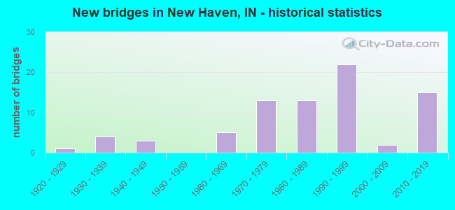
- New bridges - historical statistics
- 11920-1929
- 41930-1939
- 31940-1949
- 51960-1969
- 131970-1979
- 131980-1989
- 221990-1999
- 22000-2009
- 152010-2019
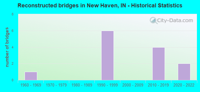
- Reconstructed bridges - Historical Statistics
- 11960-1969
- 01970-1979
- 01980-1989
- 61990-1999
- 02000-2009
- 42010-2019
- 22020-2022
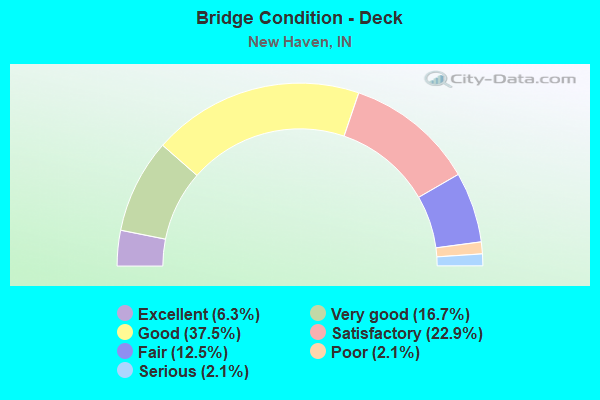
- Bridge Condition - Deck
- 6.3%Excellent
- 16.7%Very good
- 37.5%Good
- 22.9%Satisfactory
- 12.5%Fair
- 2.1%Poor
- 2.1%Serious
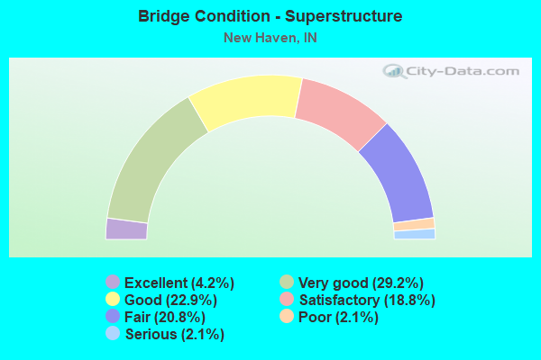
- Bridge Condition - Superstructure
- 4.2%Excellent
- 29.2%Very good
- 22.9%Good
- 18.8%Satisfactory
- 20.8%Fair
- 2.1%Poor
- 2.1%Serious
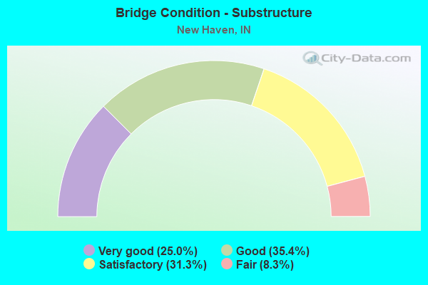
- Bridge Condition - Substructure
- 25.0%Very good
- 35.4%Good
- 31.3%Satisfactory
- 8.3%Fair
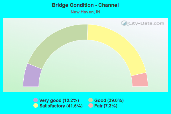
- Bridge Condition - Channel
- 12.2%Very good
- 39.0%Good
- 41.5%Satisfactory
- 7.3%Fair
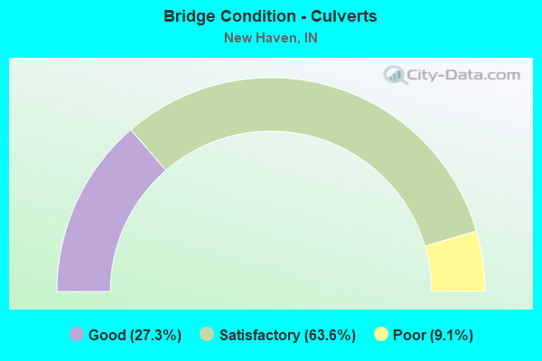
- Bridge Condition - Culverts
- 27.3%Good
- 63.6%Satisfactory
- 9.1%Poor
Find on map >> Show street view
Structure Number: 200147, Location: 00.30 S PARENT RD (Lat: 41.103761, Lng: -84.986889), Route carried "on" structure: County highway 76, Year Built: 1971, Status: Open, Structure Length: 1.14m (3.74ft), Average Daily Traffic: 468 (year 2018), Truck Traffic: 5%, Average Future Daily Traffic: 700 (year 2038), Design Load: HS 20, Features Intersected: SIX MILE CREEK, Facility Carried by Structure: RIVER RUN RD
Minimum Vertical Clearance: 30+ m (98+ ft), Kilometerpoint: 0.000, Lanes on structure: 2, Owner: County Highway Agency, Approaching Roadway Width: 7.3m (24.0ft), Skew: 3 degrees, Material/Design: Prestressed concrete, Design/Construction: Box Beam or Girders - Multiple, Number Of Spans In Main Unit: 1, Length of Maximum Span: 10.5m (34.4ft), Curb-To-Curb Width: 8.0m (26.2ft), Out-to-Out Width: 8.6m (28.2ft)
Condition: Deck: Fair, Superstructure: Fair, Substructure: Satisfactory, Channel: Satisfactory, Operating Rating: 49.9 metric tons, Method Used To Determine Operating Rating: Load Factor (LF), Inventory Rating: 29.9 metric tons, Method Used To Determine Inventory Rating: Load Factor (LF), Structural Evaluation: Somewhat better than minimum adequacy, Deck Geometry: Somewhat better than minimum adequacy, Waterway Adequacy: Better than present minimum criteria, Approach Roadway Alignment: Equal to present desirable criteria, Designated Inspection Frequency: Every 24 months, Inspection Date: May 2020, Deck Structure Type: Concrete Precast Panels, Wearing Surface/Protective System: Wearing Surface: Bituminous
Find on map >> Show street view
Structure Number: 200238, Location: 00.40 W HARTZELL ROAD (Lat: 41.033661, Lng: -85.036339), Route carried "on" structure: County highway , Year Built: 1970, Status: Open, Structure Length: 0.82m (2.69ft), Average Daily Traffic: 364 (year 2018), Truck Traffic: 5%, Average Future Daily Traffic: 544 (year 2038), Features Intersected: ADAMS DRAIN, Facility Carried by Structure: PAULDING RD
Minimum Vertical Clearance: 30+ m (98+ ft), Kilometerpoint: 0.000, Lanes on structure: 2, Owner: County Highway Agency, Approaching Roadway Width: 7.3m (24.0ft), Material/Design: Prestressed concrete, Design/Construction: Box Beam or Girders - Multiple, Number Of Spans In Main Unit: 1, Length of Maximum Span: 7.9m (25.9ft), Curb-To-Curb Width: 9.6m (31.5ft), Out-to-Out Width: 9.8m (32.2ft)
Condition: Deck: Fair, Superstructure: Fair, Substructure: Satisfactory, Channel: Satisfactory, Operating Rating: 55.0 metric tons, Method Used To Determine Operating Rating: Load Factor (LF), Inventory Rating: 32.9 metric tons, Method Used To Determine Inventory Rating: Load Factor (LF), Structural Evaluation: Somewhat better than minimum adequacy, Deck Geometry: Equal to present minimum criteria, Waterway Adequacy: Equal to present minimum criteria, Approach Roadway Alignment: Equal to present desirable criteria, Length Of Structure Improvement: 0.82m (2.69ft), Designated Inspection Frequency: Every 24 months, Inspection Date: May 2020, Bridge Improvement Cost: $65,000, Roadway Improvement Cost: $13,000, Total Project Cost: $104,000 ( Estimate for 2020), Deck Structure Type: Concrete Precast Panels, Wearing Surface/Protective System: Wearing Surface: Bituminous
Find on map >> Show street view
Structure Number: 200278, Location: 00.10 W OF STATE ST (Lat: 41.072819, Lng: -85.023131), Route carried "on" structure: City street , Year Built: 1970, Status: Posted for load, Structure Length: 3.38m (11.09ft), Average Daily Traffic: 974 (year 2018), Truck Traffic: 5%, Average Future Daily Traffic: 1,620 (year 2038), Design Load: HS 20, Features Intersected: TRIER DRAIN, Facility Carried by Structure: MAIN ST
Minimum Vertical Clearance: 30+ m (98+ ft), Kilometerpoint: 0.000, Lanes on structure: 2, Owner: County Highway Agency, Approaching Roadway Width: 7.3m (24.0ft), Material/Design: Prestressed concrete, Design/Construction: Box Beam or Girders - Multiple, Number Of Spans In Main Unit: 3, Length of Maximum Span: 12.2m (40.0ft), Curb or Sidewalk Widths: Left: 0.3m (1.0ft), Right: 0.3m (1.0ft), Curb-To-Curb Width: 9.2m (30.2ft), Out-to-Out Width: 9.8m (32.2ft)
Condition: Deck: Serious, Superstructure: Serious, Substructure: Satisfactory, Channel: Satisfactory, Operating Rating: 10.6 metric tons, Method Used To Determine Operating Rating: Load Factor (LF), Inventory Rating: 6.4 metric tons, Method Used To Determine Inventory Rating: Load Factor (LF), Structural Evaluation: High priority of corrective action, Deck Geometry: Equal to present minimum criteria, Waterway Adequacy: Better than present minimum criteria, Approach Roadway Alignment: Equal to present desirable criteria, Bridge Posting: Required (Relationship of Operating Rating to Maximum Legal Load: > 39.9% below), Length Of Structure Improvement: 3.66m (12.01ft), Designated Inspection Frequency: Every 12 months, Inspection Date: May 2021, Bridge Improvement Cost: $986,000, Roadway Improvement Cost: $198,000, Total Project Cost: $1,468,000 ( Estimate for 2021), Deck Structure Type: Concrete Precast Panels, Wearing Surface/Protective System: Wearing Surface: Bituminous
Find on map >> Show street view
Structure Number: 200279, Location: 00.20 E OF GREEN ST (Lat: 41.073781, Lng: -85.008389), Route carried "on" structure: City street , Year Built: 1970, Status: Open, Structure Length: 1.19m (3.90ft), Average Daily Traffic: 1,683 (year 2018), Truck Traffic: 5%, Average Future Daily Traffic: 2,798 (year 2038), Design Load: HS 20, Features Intersected: A. MARTIN DRAIN, Facility Carried by Structure: SUMMIT ST
Minimum Vertical Clearance: 30+ m (98+ ft), Kilometerpoint: 0.000, Lanes on structure: 2, Owner: County Highway Agency, Approaching Roadway Width: 8.5m (27.9ft), Skew: 1 degrees, Material/Design: Prestressed concrete, Design/Construction: Box Beam or Girders - Multiple, Number Of Spans In Main Unit: 1, Length of Maximum Span: 11.2m (36.7ft), Curb or Sidewalk Widths: Left: 1.2m (3.9ft), Right: 1.2m (3.9ft), Curb-To-Curb Width: 9.2m (30.2ft), Out-to-Out Width: 12.3m (40.4ft)
Condition: Deck: Good, Superstructure: Fair, Substructure: Satisfactory, Channel: Satisfactory, Operating Rating: 81.9 metric tons, Method Used To Determine Operating Rating: Load Factor (LF), Inventory Rating: 49.1 metric tons, Method Used To Determine Inventory Rating: Load Factor (LF), Structural Evaluation: Somewhat better than minimum adequacy, Deck Geometry: Somewhat better than minimum adequacy, Waterway Adequacy: Better than present minimum criteria, Approach Roadway Alignment: Equal to present desirable criteria, Designated Inspection Frequency: Every 24 months, Inspection Date: May 2020, Deck Structure Type: Concrete Cast-file-Place, Wearing Surface/Protective System: Wearing Surface: Monolithic Concrete, Deck Protection: Epoxy Coated Reinforcing
Find on map >> Show street view
Structure Number: 200286, Location: 00.25 S PAULDING ROAD (Lat: 41.031961, Lng: -84.941350), Route carried "on" structure: County highway , Year Built: 1973, Status: Open, Structure Length: 0.82m (2.69ft), Average Daily Traffic: 104 (year 2018), Truck Traffic: 5%, Average Future Daily Traffic: 156 (year 2038), Design Load: HS 20, Features Intersected: MCHENRY DRAIN, Facility Carried by Structure: FACKLER RD
Minimum Vertical Clearance: 30+ m (98+ ft), Kilometerpoint: 0.000, Lanes on structure: 2, Owner: County Highway Agency, Approaching Roadway Width: 4.9m (16.1ft), Material/Design: Prestressed concrete, Design/Construction: Box Beam or Girders - Multiple, Number Of Spans In Main Unit: 1, Length of Maximum Span: 7.6m (24.9ft), Curb-To-Curb Width: 9.6m (31.5ft), Out-to-Out Width: 9.8m (32.2ft)
Condition: Deck: Satisfactory, Superstructure: Satisfactory, Substructure: Satisfactory, Channel: Good, Operating Rating: 68.3 metric tons, Method Used To Determine Operating Rating: Load Factor (LF), Inventory Rating: 40.9 metric tons, Method Used To Determine Inventory Rating: Load Factor (LF), Structural Evaluation: Equal to present minimum criteria, Deck Geometry: Equal to present minimum criteria, Waterway Adequacy: Better than present minimum criteria, Approach Roadway Alignment: Equal to present desirable criteria, Designated Inspection Frequency: Every 24 months, Inspection Date: May 2020, Deck Structure Type: Concrete Precast Panels
Find on map >> Show street view
Structure Number: 200297, Location: 00.20 W MINNICH ROAD (Lat: 41.019769, Lng: -85.003189), Route carried "on" structure: County highway , Year Built: 1975, Status: Posted for load, Structure Length: 1.23m (4.04ft), Average Daily Traffic: 1,483 (year 2018), Truck Traffic: 5%, Average Future Daily Traffic: 2,216 (year 2038), Design Load: HS 20, Features Intersected: SCHMIDT DRAIN, Facility Carried by Structure: TILLMAN RD
Minimum Vertical Clearance: 30+ m (98+ ft), Kilometerpoint: 0.000, Lanes on structure: 2, Owner: County Highway Agency, Approaching Roadway Width: 7.6m (24.9ft), Material/Design: Prestressed concrete, Design/Construction: Box Beam or Girders - Multiple, Number Of Spans In Main Unit: 1, Length of Maximum Span: 11.6m (38.1ft), Curb-To-Curb Width: 12.6m (41.3ft), Out-to-Out Width: 13.5m (44.3ft)
Condition: Deck: Fair, Superstructure: Fair, Substructure: Good, Channel: Good, Operating Rating: 33.2 metric tons, Method Used To Determine Operating Rating: Load Factor (LF), Inventory Rating: 14.2 metric tons, Method Used To Determine Inventory Rating: Load Factor (LF), Structural Evaluation: Meets minimum limits, Deck Geometry: Better than present minimum criteria, Waterway Adequacy: Better than present minimum criteria, Approach Roadway Alignment: Equal to present desirable criteria, Length Of Structure Improvement: 1.23m (4.04ft), Designated Inspection Frequency: Every 24 months, Inspection Date: May 2020, Bridge Improvement Cost: $133,000, Roadway Improvement Cost: $27,000, Total Project Cost: $212,000 ( Estimate for 2020), Deck Structure Type: Concrete Cast-file-Place, Wearing Surface/Protective System: Wearing Surface: Monolithic Concrete
Find on map >> Show street view
Structure Number: 200332, Location: 00.15 W WEBSTER ROAD (Lat: 41.079750, Lng: -84.926611), Route carried "on" structure: County highway , Year Built: 1986, Status: Open, Structure Length: 0.76m (2.49ft), Average Daily Traffic: 1,041 (year 2018), Truck Traffic: 5%, Average Future Daily Traffic: 1,555 (year 2038), Design Load: HS 20, Features Intersected: LOMONT DRAIN, Facility Carried by Structure: EDGERTON RD
Minimum Vertical Clearance: 30+ m (98+ ft), Kilometerpoint: 0.000, Lanes on structure: 2, Owner: County Highway Agency, Approaching Roadway Width: 6.4m (21.0ft), Skew: 3 degrees, Material/Design: Steel, Design/Construction: Culvert, Number Of Spans In Main Unit: 2, Length of Maximum Span: 3.5m (11.5ft), Curb-To-Curb Width: 9.8m (32.2ft), Out-to-Out Width: 24.4m (80.1ft)
Condition: Channel: Good, Culverts: Satisfactory, Inventory Rating: 32.7 metric tons, Method Used To Determine Inventory Rating: Load Factor (LF), Structural Evaluation: Equal to present minimum criteria, Deck Geometry: Somewhat better than minimum adequacy, Waterway Adequacy: Better than present minimum criteria, Approach Roadway Alignment: Equal to present desirable criteria, Designated Inspection Frequency: Every 24 months, Inspection Date: June 2020, Wearing Surface/Protective System: Wearing Surface: Bituminous
Find on map >> Show street view
Structure Number: 200334, Location: 00.50 E LANDIN ROAD (Lat: 41.087981, Lng: -85.009161), Route carried "on" structure: County highway , Year Built: 1932, Status: Posted for load, Structure Length: 0.70m (2.30ft), Average Daily Traffic: 963 (year 2018), Truck Traffic: 5%, Average Future Daily Traffic: 1,439 (year 2038), Features Intersected: BULLERMAN DRAIN, Facility Carried by Structure: NORTH RIVER RD
Minimum Vertical Clearance: 30+ m (98+ ft), Kilometerpoint: 0.000, Lanes on structure: 2, Owner: County Highway Agency, Approaching Roadway Width: 6.1m (20.0ft), Skew: 2 degrees, Material/Design: Concrete, Design/Construction: Slab, Number Of Spans In Main Unit: 1, Length of Maximum Span: 6.4m (21.0ft), Curb-To-Curb Width: 7.5m (24.6ft), Out-to-Out Width: 8.1m (26.6ft)
Condition: Deck: Satisfactory, Superstructure: Satisfactory, Substructure: Satisfactory, Channel: Satisfactory, Operating Rating: 34.4 metric tons, Method Used To Determine Operating Rating: Load Factor (LF), Inventory Rating: 20.6 metric tons, Method Used To Determine Inventory Rating: Load Factor (LF), Structural Evaluation: Somewhat better than minimum adequacy, Deck Geometry: Meets minimum limits, Waterway Adequacy: Better than present minimum criteria, Approach Roadway Alignment: Equal to present desirable criteria, Designated Inspection Frequency: Every 24 months, Inspection Date: June 2020, Deck Structure Type: Concrete Cast-file-Place, Wearing Surface/Protective System: Wearing Surface: Bituminous
Find on map >> Show street view
Structure Number: 20034, Location: 00.70 E GREEN ST (Lat: 41.070539, Lng: -84.998081), Route carried "on" structure: City street , Year Built: 1947, Year Reconstructed: 1990, Status: Open, Structure Length: 0.85m (2.79ft), Average Daily Traffic: 15,000 (year 2016), Truck Traffic: 5%, Average Future Daily Traffic: 18,000 (year 2036), Features Intersected: A MARTIN DRAIN, Facility Carried by Structure: DAWKINS RD
Minimum Vertical Clearance: 30+ m (98+ ft), Kilometerpoint: 0.000, Lanes on structure: 2, Owner: County Highway Agency, Approaching Roadway Width: 11.0m (36.1ft), Skew: 2 degrees, Material/Design: Concrete, Design/Construction: Arch - Deck, Number Of Spans In Main Unit: 1, Length of Maximum Span: 7.6m (24.9ft), Curb-To-Curb Width: 11.5m (37.7ft), Out-to-Out Width: 12.2m (40.0ft)
Condition: Deck: Good, Superstructure: Fair, Substructure: Fair, Channel: Satisfactory, Operating Rating: 40.8 metric tons, Method Used To Determine Operating Rating: Field evaluation and documented engineering judgment, Inventory Rating: 32.7 metric tons, Method Used To Determine Inventory Rating: Field evaluation and documented engineering judgment, Structural Evaluation: Somewhat better than minimum adequacy, Deck Geometry: Meets minimum limits, Waterway Adequacy: Better than present minimum criteria, Approach Roadway Alignment: Equal to present desirable criteria, Designated Inspection Frequency: Every 24 months, Inspection Date: May 2020, Deck Structure Type: Concrete Cast-file-Place, Wearing Surface/Protective System: Wearing Surface: Bituminous
Find on map >> Show street view
Structure Number: 200342, Location: 00.10 E OF GREEN ST (Lat: 41.077750, Lng: -85.008919), Route carried "on" structure: City street , Year Built: 1945, Status: Open, Structure Length: 0.82m (2.69ft), Average Daily Traffic: 7,000 (year 2016), Truck Traffic: 5%, Average Future Daily Traffic: 10,000 (year 2036), Features Intersected: A. MARTIN DRAIN, Facility Carried by Structure: ROSE AVE
Minimum Vertical Clearance: 30+ m (98+ ft), Kilometerpoint: 0.000, Lanes on structure: 2, Owner: County Highway Agency, Approaching Roadway Width: 8.5m (27.9ft), Material/Design: Concrete, Design/Construction: Culvert, Number Of Spans In Main Unit: 1, Length of Maximum Span: 7.6m (24.9ft), Curb-To-Curb Width: 12.3m (40.4ft), Out-to-Out Width: 16.2m (53.1ft)
Condition: Channel: Satisfactory, Culverts: Satisfactory, Operating Rating: 44.1 metric tons, Method Used To Determine Operating Rating: Field evaluation and documented engineering judgment, Inventory Rating: 32.7 metric tons, Method Used To Determine Inventory Rating: Field evaluation and documented engineering judgment, Structural Evaluation: Equal to present minimum criteria, Deck Geometry: Somewhat better than minimum adequacy, Waterway Adequacy: Better than present minimum criteria, Approach Roadway Alignment: Equal to present desirable criteria, Designated Inspection Frequency: Every 24 months, Inspection Date: May 2020, Wearing Surface/Protective System: Wearing Surface: Bituminous
Find on map >> Show street view
Structure Number: 200343, Location: 00.20 E OF HARTZELL RD (Lat: 41.070131, Lng: -85.026931), Route carried "on" structure: City street , Year Built: 1936, Status: Open, Structure Length: 2.01m (6.59ft), Average Daily Traffic: 15,000 (year 2016), Truck Traffic: 5%, Average Future Daily Traffic: 22,000 (year 2036), Features Intersected: TRIER DRAIN, Facility Carried by Structure: E LINCOLN HWY
Minimum Vertical Clearance: 30+ m (98+ ft), Kilometerpoint: 0.000, Lanes on structure: 4, Owner: County Highway Agency, Approaching Roadway Width: 13.4m (44.0ft), Skew: 1 degrees, Material/Design: Concrete, Design/Construction: Culvert, Number Of Spans In Main Unit: 1, Length of Maximum Span: 18.9m (62.0ft), Curb or Sidewalk Widths: Left: 1.6m (5.2ft), Right: 1.6m (5.2ft), Curb-To-Curb Width: 14.2m (46.6ft), Out-to-Out Width: 18.3m (60.0ft)
Condition: Channel: Satisfactory, Culverts: Satisfactory, Operating Rating: 44.1 metric tons, Method Used To Determine Operating Rating: Field evaluation and documented engineering judgment, Inventory Rating: 32.7 metric tons, Method Used To Determine Inventory Rating: Field evaluation and documented engineering judgment, Structural Evaluation: Equal to present minimum criteria, Deck Geometry: High priority of replacement, Waterway Adequacy: Better than present minimum criteria, Approach Roadway Alignment: Equal to present desirable criteria, Designated Inspection Frequency: Every 24 months, Inspection Date: May 2020, Wearing Surface/Protective System: Wearing Surface: Bituminous
Find on map >> Show street view
Structure Number: 200345, Location: 00.21 W BERTHAUD ROAD (Lat: 41.109019, Lng: -84.948250), Route carried "on" structure: County highway 24, Year Built: 1945, Status: Open, Structure Length: 0.82m (2.69ft), Average Daily Traffic: 2,500 (year 2016), Truck Traffic: 5%, Average Future Daily Traffic: 3,125 (year 2036), Features Intersected: LOMONT DRAIN
Minimum Vertical Clearance: 30+ m (98+ ft), Kilometerpoint: 0.000, Lanes on structure: 2, Owner: County Highway Agency, Approaching Roadway Width: 11.0m (36.1ft), Material/Design: Concrete, Design/Construction: Culvert, Number Of Spans In Main Unit: 1, Length of Maximum Span: 7.6m (24.9ft), Curb-To-Curb Width: 13.5m (44.3ft), Out-to-Out Width: 16.1m (52.8ft)
Condition: Channel: Fair, Culverts: Satisfactory, Operating Rating: 40.8 metric tons, Method Used To Determine Operating Rating: Field evaluation and documented engineering judgment, Inventory Rating: 32.7 metric tons, Method Used To Determine Inventory Rating: Field evaluation and documented engineering judgment, Structural Evaluation: Equal to present minimum criteria, Deck Geometry: Superior to present desirable criteria, Waterway Adequacy: Better than present minimum criteria, Approach Roadway Alignment: Equal to present desirable criteria, Designated Inspection Frequency: Every 24 months, Inspection Date: May 2020, Wearing Surface/Protective System: Wearing Surface: Bituminous
Find on map >> Show street view
Structure Number: 200403, Location: 00.40 S SR 14 (Lat: 41.066100, Lng: -84.981161), Route carried "on" structure: City street , Year Built: 1996, Status: Open, Structure Length: 1.52m (4.99ft), Average Daily Traffic: 1,145 (year 2018), Truck Traffic: 20%, Average Future Daily Traffic: 1,711 (year 2038), Design Load: HS 20, Features Intersected: A MARTIN DRAIN, Facility Carried by Structure: DOYLE RD
Minimum Vertical Clearance: 30+ m (98+ ft), Kilometerpoint: 0.000, Lanes on structure: 2, Owner: County Highway Agency, Approaching Roadway Width: 9.1m (29.9ft), Skew: 4 degrees, Material/Design: Wood or Timber, Design/Construction: Slab, Number Of Spans In Main Unit: 3, Length of Maximum Span: 7.9m (25.9ft), Curb or Sidewalk Widths: Left: 0.2m (0.7ft), Right: 0.2m (0.7ft), Curb-To-Curb Width: 9.8m (32.2ft), Out-to-Out Width: 10.2m (33.5ft)
Condition: Deck: Satisfactory, Superstructure: Satisfactory, Substructure: Good, Channel: Good, Operating Rating: 53.4 metric tons, Method Used To Determine Operating Rating: Allowable Stress (AS), Inventory Rating: 38.0 metric tons, Method Used To Determine Inventory Rating: Allowable Stress (AS), Structural Evaluation: Equal to present minimum criteria, Deck Geometry: Somewhat better than minimum adequacy, Waterway Adequacy: Equal to present minimum criteria, Approach Roadway Alignment: Equal to present desirable criteria, Designated Inspection Frequency: Every 24 months, Inspection Date: May 2020, Deck Structure Type: Wood or Timber, Wearing Surface/Protective System: Wearing Surface: Bituminous, Deck Protection: Internally Sealed
Find on map >> Show street view
Structure Number: 200607, Location: 00.10 N OF COURTNEY DR (Lat: 41.064861, Lng: -85.040831), Route carried "on" structure: City street , Year Built: 1965, Year Reconstructed: 1996, Status: Open, Structure Length: 1.55m (5.09ft), Average Daily Traffic: 579 (year 2018), Truck Traffic: 1%, Average Future Daily Traffic: 962 (year 2038), Design Load: HS 20, Features Intersected: TRIER DRAIN, Facility Carried by Structure: BROOKWOOD DR
Minimum Vertical Clearance: 30+ m (98+ ft), Kilometerpoint: 0.000, Lanes on structure: 2, Owner: County Highway Agency, Approaching Roadway Width: 7.3m (24.0ft), Material/Design: Steel, Design/Construction: Stringer/Multi-beam, Number Of Spans In Main Unit: 1, Length of Maximum Span: 14.3m (46.9ft), Curb or Sidewalk Widths: Left: 0.0m, Right: 2.1m (6.9ft), Curb-To-Curb Width: 8.1m (26.6ft), Out-to-Out Width: 11.1m (36.4ft)
Condition: Deck: Satisfactory, Superstructure: Good, Substructure: Good, Channel: Good, Operating Rating: 88.8 metric tons, Method Used To Determine Operating Rating: Load Factor (LF), Inventory Rating: 53.2 metric tons, Method Used To Determine Inventory Rating: Load Factor (LF), Structural Evaluation: Better than present minimum criteria, Deck Geometry: Somewhat better than minimum adequacy, Waterway Adequacy: Better than present minimum criteria, Approach Roadway Alignment: Equal to present desirable criteria, Designated Inspection Frequency: Every 24 months, Inspection Date: May 2020, Deck Structure Type: Concrete Cast-file-Place, Wearing Surface/Protective System: Wearing Surface: Monolithic Concrete
Find on map >> Show street view
Structure Number: 200608, Location: 00.30 W MINNICH RD (Lat: 41.055669, Lng: -85.005172), Route carried "on" structure: City street , Year Built: 1996, Status: Open, Structure Length: 4.19m (13.75ft), Average Daily Traffic: 3,000 (year 2016), Truck Traffic: 5%, Average Future Daily Traffic: 5,000 (year 2036), Features Intersected: COCHOIT DRAIN, Facility Carried by Structure: MOELLER RD
Minimum Vertical Clearance: 30+ m (98+ ft), Kilometerpoint: 0.000, Lanes on structure: 2, Owner: County Highway Agency, Approaching Roadway Width: 9.1m (29.9ft), Skew: 8 degrees, Material/Design: Concrete, Design/Construction: Culvert, Number Of Spans In Main Unit: 2, Length of Maximum Span: 17.5m (57.4ft), Curb-To-Curb Width: 13.7m (44.9ft), Out-to-Out Width: 13.7m (44.9ft)
Condition: Channel: Satisfactory, Culverts: Good, Operating Rating: 40.8 metric tons, Method Used To Determine Operating Rating: Field evaluation and documented engineering judgment, Inventory Rating: 32.7 metric tons, Method Used To Determine Inventory Rating: Field evaluation and documented engineering judgment, Structural Evaluation: Better than present minimum criteria, Deck Geometry: Superior to present desirable criteria, Waterway Adequacy: Better than present minimum criteria, Approach Roadway Alignment: Equal to present desirable criteria, Designated Inspection Frequency: Every 24 months, Inspection Date: May 2020, Wearing Surface/Protective System: Wearing Surface: Bituminous
Find on map >> Show street view
Structure Number: 200646, Location: 00.20 N OF SEILER ROAD (Lat: 41.050369, Lng: -85.010750), Route carried "on" structure: City street , Year Built: 1970, Status: Open, Structure Length: 0.76m (2.49ft), Average Daily Traffic: 1,578 (year 2018), Truck Traffic: 5%, Average Future Daily Traffic: 2,623 (year 2038), Design Load: HS 20, Features Intersected: KAMP DRAIN, Facility Carried by Structure: GREEN RD
Minimum Vertical Clearance: 30+ m (98+ ft), Kilometerpoint: 0.000, Lanes on structure: 2, Owner: County Highway Agency, Approaching Roadway Width: 6.7m (22.0ft), Skew: 5 degrees, Material/Design: Steel, Design/Construction: Culvert, Number Of Spans In Main Unit: 2, Length of Maximum Span: 3.7m (12.1ft), Curb-To-Curb Width: 6.7m (22.0ft), Out-to-Out Width: 24.4m (80.1ft)
Condition: Channel: Good, Culverts: Satisfactory, Inventory Rating: 32.7 metric tons, Method Used To Determine Inventory Rating: Load Factor (LF), Structural Evaluation: Equal to present minimum criteria, Deck Geometry: High priority of corrective action, Waterway Adequacy: Somewhat better than minimum adequacy, Approach Roadway Alignment: Equal to present desirable criteria, Designated Inspection Frequency: Every 24 months, Inspection Date: May 2020, Wearing Surface/Protective System: Wearing Surface: Bituminous
Find on map >> Show street view
Structure Number: 20065, Location: 00.32 N HARPER ROAD (Lat: 41.091339, Lng: -84.943681), Route carried "on" structure: County highway 425, Year Built: 1980, Status: Open, Structure Length: 1.07m (3.51ft), Average Daily Traffic: 104 (year 2018), Truck Traffic: 5%, Average Future Daily Traffic: 156 (year 2038), Design Load: HS 20, Features Intersected: BANDELIER #3 DRAIN, Facility Carried by Structure: BERTHAUD RD
Minimum Vertical Clearance: 30+ m (98+ ft), Kilometerpoint: 0.000, Lanes on structure: 2, Owner: County Highway Agency, Approaching Roadway Width: 4.9m (16.1ft), Skew: 6 degrees, Material/Design: Steel, Design/Construction: Culvert, Number Of Spans In Main Unit: 1, Length of Maximum Span: 10.5m (34.4ft), Curb-To-Curb Width: 6.9m (22.6ft), Out-to-Out Width: 24.4m (80.1ft)
Condition: Channel: Satisfactory, Culverts: Satisfactory, Inventory Rating: 83.9 metric tons, Method Used To Determine Inventory Rating: Load and Resistance Factor (LRFR), Structural Evaluation: Equal to present minimum criteria, Deck Geometry: Meets minimum limits, Waterway Adequacy: Equal to present minimum criteria, Approach Roadway Alignment: Equal to present desirable criteria, Designated Inspection Frequency: Every 24 months, Inspection Date: May 2020, Wearing Surface/Protective System: Wearing Surface: Gravel
Find on map >> Show street view
Structure Number: 200667, Location: 00.15 N SR 930 (Lat: 41.071650, Lng: -85.058811), Route carried "on" structure: City street , Year Built: 2012, Status: Open, Structure Length: 2.93m (9.61ft), Average Daily Traffic: 19,150 (year 2016), Truck Traffic: 6%, Average Future Daily Traffic: 29,575 (year 2036), Design Load: HS 20, Features Intersected: NORFOLK SOUTHERN R/R, Facility Carried by Structure: MAPLECREST RD
Minimum Vertical Clearance: 30+ m (98+ ft), Kilometerpoint: 0.000, Lanes on structure: 5, Owner: County Highway Agency, Approaching Roadway Width: 20.1m (65.9ft), Material/Design: Prestressed concrete, Design/Construction: Stringer/Multi-beam, Number Of Spans In Main Unit: 1, Length of Maximum Span: 28.7m (94.2ft), Curb or Sidewalk Widths: Left: 0.0m, Right: 3.0m (9.8ft), Curb-To-Curb Width: 20.1m (65.9ft), Out-to-Out Width: 24.2m (79.4ft)
Condition: Deck: Good, Superstructure: Very good, Substructure: Very good, Operating Rating: 59.4 metric tons, Method Used To Determine Operating Rating: Load Factor (LF), Inventory Rating: 32.3 metric tons, Method Used To Determine Inventory Rating: Load Factor (LF), Structural Evaluation: Better than present minimum criteria, Deck Geometry: Somewhat better than minimum adequacy, Underclear: Superior to present desirable criteria, Approach Roadway Alignment: Equal to present desirable criteria, Designated Inspection Frequency: Every 24 months, Inspection Date: May 2020, Deck Structure Type: Concrete Cast-file-Place, Wearing Surface/Protective System: Wearing Surface: Monolithic Concrete, Deck Protection: Epoxy Coated Reinforcing
Find on map >> Show street view
Structure Number: 200668, Location: 00.25 N SR 930 (Lat: 41.074011, Lng: -85.058750), Route carried "on" structure: City street , Year Built: 2012, Status: Open, Structure Length: 26.47m (86.84ft), Average Daily Traffic: 19,150 (year 2016), Truck Traffic: 6%, Average Future Daily Traffic: 29,575 (year 2036), Design Load: HS 20, Features Intersected: N-S R/R & NELSON RD, Facility Carried by Structure: MAPLECREST RD
Minimum Vertical Clearance: 30+ m (98+ ft), Kilometerpoint: 0.000, Lanes on structure: 5, Lanes under structure: 2, Owner: County Highway Agency, Approaching Roadway Width: 20.1m (65.9ft), Material/Design: Prestressed concrete continuous, Design/Construction: Stringer/Multi-beam, Number Of Spans In Main Unit: 7, Length of Maximum Span: 41.1m (134.8ft), Curb or Sidewalk Widths: Left: 0.0m, Right: 3.0m (9.8ft), Curb-To-Curb Width: 20.1m (65.9ft), Out-to-Out Width: 24.2m (79.4ft)
Condition: Deck: Good, Superstructure: Very good, Substructure: Very good, Operating Rating: 40.2 metric tons, Method Used To Determine Operating Rating: Load Factor (LF), Inventory Rating: 23.8 metric tons, Method Used To Determine Inventory Rating: Load Factor (LF), Structural Evaluation: Somewhat better than minimum adequacy, Deck Geometry: Somewhat better than minimum adequacy, Underclear: Meets minimum limits, Approach Roadway Alignment: Equal to present desirable criteria, Designated Inspection Frequency: Every 24 months, Inspection Date: May 2020, Deck Structure Type: Concrete Cast-file-Place, Wearing Surface/Protective System: Wearing Surface: Monolithic Concrete, Deck Protection: Epoxy Coated Reinforcing
Find on map >> Show street view
Structure Number: 20067, Location: 00.41 S N RIVER RD (Lat: 41.081800, Lng: -85.059039), Route carried "on" structure: City street , Year Built: 2011, Status: Open, Structure Length: 0.70m (2.30ft), Average Daily Traffic: 19,150 (year 2016), Truck Traffic: 5%, Average Future Daily Traffic: 29,575 (year 2036), Features Intersected: TREATMENT PLANT ROAD, Facility Carried by Structure: MAPLECREST RD
Minimum Vertical Clearance: 30+ m (98+ ft), Kilometerpoint: 0.000, Lanes on structure: 4, Lanes under structure: 2, Owner: County Highway Agency, Approaching Roadway Width: 15.9m (52.2ft), Material/Design: Concrete, Design/Construction: Slab, Number Of Spans In Main Unit: 1, Length of Maximum Span: 6.1m (20.0ft), Curb or Sidewalk Widths: Left: 0.0m, Right: 3.0m (9.8ft), Curb-To-Curb Width: 15.9m (52.2ft), Out-to-Out Width: 27.4m (89.9ft)
Condition: Deck: Good, Superstructure: Good, Substructure: Good, Operating Rating: 44.1 metric tons, Method Used To Determine Operating Rating: Field evaluation and documented engineering judgment, Inventory Rating: 32.7 metric tons, Method Used To Determine Inventory Rating: Field evaluation and documented engineering judgment, Structural Evaluation: Better than present minimum criteria, Deck Geometry: Meets minimum limits, Underclear: High priority of corrective action, Approach Roadway Alignment: Equal to present desirable criteria, Designated Inspection Frequency: Every 24 months, Inspection Date: May 2020, Deck Structure Type: Concrete Cast-file-Place, Wearing Surface/Protective System: Wearing Surface: Monolithic Concrete, Deck Protection: Epoxy Coated Reinforcing
Find on map >> Show street view
Structure Number: 32852, Location: 01.73 W US 30 (Lat: 41.039850, Lng: -85.000786), Route carried "under" structure: Interstate 469, Year Built: 1989, Structure Length: 0. m, Average Daily Traffic: 9,740 (year 2019), Truck Traffic: 42%, Features Intersected: I-469 NB, Facility Carried by Structure: MINNICH ROAD NB
Minimum Vertical Clearance: 5.77m (18.93ft), Kilometerpoint: 28.147, Lanes on structure: 1, Lanes under structure: 6, Material/Design: Steel continuous, Design/Construction: Stringer/Multi-beam, Length of Maximum Span: 44.2m (145.0ft)
Find on map >> Show street view
Structure Number: 32852, Location: 01.73 W US 30 (Lat: 41.039850, Lng: -85.000786), Route carried "under" structure: Interstate 469, Year Built: 1989, Structure Length: 0. m, Average Daily Traffic: 9,197 (year 2019), Truck Traffic: 42%, Features Intersected: I-469 SB, Facility Carried by Structure: MINNICH ROAD NB
Minimum Vertical Clearance: 5.77m (18.93ft), Kilometerpoint: 28.147, Lanes on structure: 1, Lanes under structure: 6, Material/Design: Steel continuous, Design/Construction: Stringer/Multi-beam, Length of Maximum Span: 44.2m (145.0ft)
Find on map >> Show street view
Structure Number: 32854, Location: 07.76 E US 27 (Lat: 41.063250, Lng: -84.989478), Route carried "under" structure: State highway 930, Year Built: 1990, Structure Length: 0. m, Average Daily Traffic: 12,912 (year 2020), Truck Traffic: 20%, Features Intersected: SR 930 WB, Facility Carried by Structure: I-469 NB
Minimum Vertical Clearance: 5.03m (16.50ft), Kilometerpoint: 40.523, Lanes on structure: 2, Lanes under structure: 4, Material/Design: Steel continuous, Design/Construction: Stringer/Multi-beam, Length of Maximum Span: 36.7m (120.4ft)
Find on map >> Show street view
Structure Number: 32854, Location: 07.76 E US 27 (Lat: 41.063250, Lng: -84.989478), Route carried "under" structure: US 30, Year Built: 1990, Structure Length: 0. m, Average Daily Traffic: 12,912 (year 2020), Truck Traffic: 20%, Features Intersected: US 30 EB, Facility Carried by Structure: I-469 NB
Minimum Vertical Clearance: 5.03m (16.50ft), Kilometerpoint: 40.523, Lanes on structure: 2, Lanes under structure: 4, Material/Design: Steel continuous, Design/Construction: Stringer/Multi-beam, Length of Maximum Span: 36.7m (120.4ft)
Find on map >> Show street view
Structure Number: 32855, Location: 01.72 W US 30 (Lat: 41.040261, Lng: -85.000817), Route carried "under" structure: Interstate 469, Year Built: 1989, Structure Length: 0. m, Average Daily Traffic: 9,764 (year 2019), Truck Traffic: 42%, Features Intersected: I-469 NB, Facility Carried by Structure: MINNICH ROAD SB
Minimum Vertical Clearance: 5.33m (17.49ft), Kilometerpoint: 28.131, Lanes on structure: 1, Lanes under structure: 6, Material/Design: Steel continuous, Design/Construction: Stringer/Multi-beam, Length of Maximum Span: 44.2m (145.0ft)
Find on map >> Show street view
Structure Number: 32855, Location: 01.72 W US 30 (Lat: 41.040261, Lng: -85.000817), Route carried "under" structure: Interstate 469, Year Built: 1989, Structure Length: 0. m, Average Daily Traffic: 9,197 (year 2019), Truck Traffic: 42%, Features Intersected: I-469 SB, Facility Carried by Structure: MINNICH ROAD SB
Minimum Vertical Clearance: 5.84m (19.16ft), Kilometerpoint: 28.131, Lanes on structure: 1, Lanes under structure: 6, Material/Design: Steel continuous, Design/Construction: Stringer/Multi-beam, Length of Maximum Span: 44.2m (145.0ft)
Find on map >> Show street view
Structure Number: 76, Location: 00.53 N US 30 (Lat: 41.070789, Lng: -84.989900), Route carried "under" structure: City street , Year Built: 1991, Structure Length: 0. m, Average Daily Traffic: 3,727 (year 2020), Truck Traffic: 15%, Features Intersected: DAWKINS ROAD, Facility Carried by Structure: I-469
Minimum Vertical Clearance: 7.54m (24.74ft), Kilometerpoint: 0.000, Lanes on structure: 4, Lanes under structure: 2, Material/Design: Prestressed concrete continuous, Design/Construction: Stringer/Multi-beam, Length of Maximum Span: 26.9m (88.3ft)
Find on map >> Show street view
Structure Number: 7602, Location: 01.35 N US 30 (Lat: 41.084100, Lng: -84.992667), Route carried "under" structure: US 24, Year Built: 1992, Structure Length: 0. m, Average Daily Traffic: 8,852 (year 2020), Truck Traffic: 39%, Features Intersected: US 24 WB, Facility Carried by Structure: I-469 NB
Minimum Vertical Clearance: 5.26m (17.26ft), Kilometerpoint: 50.212, Lanes on structure: 3, Lanes under structure: 3, Material/Design: Steel continuous, Design/Construction: Stringer/Multi-beam, Length of Maximum Span: 38.1m (125.0ft)
Find on map >> Show street view
Structure Number: 7602, Location: 01.35 N US 30 (Lat: 41.084100, Lng: -84.992667), Route carried "under" structure: US 24, Year Built: 1992, Structure Length: 0. m, Average Daily Traffic: 8,500 (year 2020), Truck Traffic: 39%, Features Intersected: US 24 EB, Facility Carried by Structure: I-469 NB
Minimum Vertical Clearance: 5.26m (17.26ft), Kilometerpoint: 50.212, Lanes on structure: 3, Lanes under structure: 3, Material/Design: Steel continuous, Design/Construction: Stringer/Multi-beam, Length of Maximum Span: 38.1m (125.0ft)
Find on map >> Show street view
Structure Number: 7605, Location: 00.64 N US 24 (Lat: 41.093069, Lng: -84.994714), Route carried "under" structure: County highway , Year Built: 1991, Structure Length: 0. m, Average Daily Traffic: 390 (year 2020), Truck Traffic: 1%, Features Intersected: NORTH RIVER ROAD, Facility Carried by Structure: I-469 NB
Minimum Vertical Clearance: 4.52m (14.83ft), Kilometerpoint: 0.000, Lanes on structure: 2, Lanes under structure: 2, Material/Design: Prestressed concrete continuous, Design/Construction: Stringer/Multi-beam, Length of Maximum Span: 14.2m (46.6ft)
Find on map >> Show street view
Structure Number: 7606, Location: 00.64 N US 24 (Lat: 41.093039, Lng: -84.994889), Route carried "under" structure: County highway , Year Built: 1991, Structure Length: 0. m, Average Daily Traffic: 390 (year 2020), Truck Traffic: 1%, Features Intersected: NORTH RIVER ROAD, Facility Carried by Structure: I-469 SB
Minimum Vertical Clearance: 4.50m (14.76ft), Kilometerpoint: 0.000, Lanes on structure: 2, Lanes under structure: 2, Material/Design: Prestressed concrete continuous, Design/Construction: Stringer/Multi-beam, Length of Maximum Span: 14.2m (46.6ft)
Find on map >> Show street view
Structure Number: 7614, Location: 07.76 E US 27 (Lat: 41.063269, Lng: -84.989661), Route carried "under" structure: US 30, Year Built: 1990, Structure Length: 0. m, Average Daily Traffic: 12,912 (year 2020), Truck Traffic: 11%, Features Intersected: US 30 EB, Facility Carried by Structure: I-469 SB
Minimum Vertical Clearance: 5.13m (16.83ft), Kilometerpoint: 40.507, Lanes on structure: 3, Lanes under structure: 2, Material/Design: Steel continuous, Design/Construction: Stringer/Multi-beam, Length of Maximum Span: 36.7m (120.4ft)
Find on map >> Show street view
Structure Number: 7614, Location: 07.76 E US 27 (Lat: 41.063269, Lng: -84.989661), Route carried "under" structure: State highway 930, Year Built: 1990, Structure Length: 0. m, Average Daily Traffic: 12,912 (year 2020), Truck Traffic: 11%, Features Intersected: SR 930 WB, Facility Carried by Structure: I-469 SB
Minimum Vertical Clearance: 5.13m (16.83ft), Kilometerpoint: 40.507, Lanes on structure: 3, Lanes under structure: 2, Material/Design: Steel continuous, Design/Construction: Stringer/Multi-beam, Length of Maximum Span: 36.7m (120.4ft)
Find on map >> Show street view
Structure Number: 79868, Location: 2.15 E I-469 (Lat: 41.090311, Lng: -84.982219), Route carried "under" structure: County highway , Year Built: 2011, Structure Length: 0. m, Average Daily Traffic: 253 (year 2010), Truck Traffic: 3%, Features Intersected: Bruick Road, Facility Carried by Structure: US 24 EB
Minimum Vertical Clearance: 5.72m (18.77ft), Kilometerpoint: 44.193, Lanes on structure: 3, Lanes under structure: 2, Material/Design: Prestressed concrete, Design/Construction: Stringer/Multi-beam, Length of Maximum Span: 19.7m (64.6ft)
Find on map >> Show street view
Structure Number: 7987, Location: 1.10 E I-469 (Lat: 41.090311, Lng: -84.982219), Route carried "under" structure: County highway , Year Built: 2011, Structure Length: 0. m, Average Daily Traffic: 470 (year 2010), Truck Traffic: 6%, Features Intersected: Doyle Road, Facility Carried by Structure: US 24 EB
Minimum Vertical Clearance: 4.72m (15.49ft), Kilometerpoint: 41.940, Lanes on structure: 2, Lanes under structure: 2, Material/Design: Prestressed concrete, Design/Construction: Stringer/Multi-beam, Length of Maximum Span: 19.2m (63.0ft)
Find on map >> Show street view
Structure Number: 79872, Location: 1.10 E I-469 (Lat: 41.090311, Lng: -84.982219), Route carried "under" structure: County highway , Year Built: 2011, Structure Length: 0. m, Average Daily Traffic: 470 (year 2010), Truck Traffic: 6%, Features Intersected: DOYLE ROAD, Facility Carried by Structure: US 24 WB
Minimum Vertical Clearance: 4.72m (15.49ft), Kilometerpoint: 41.940, Lanes on structure: 2, Lanes under structure: 2, Material/Design: Prestressed concrete, Design/Construction: Stringer/Multi-beam, Length of Maximum Span: 19.2m (63.0ft)
Find on map >> Show street view
Structure Number: 79874, Location: 2.15 E I-469 (Lat: 41.090311, Lng: -84.982219), Route carried "under" structure: County highway , Year Built: 2011, Structure Length: 0. m, Average Daily Traffic: 253 (year 2010), Truck Traffic: 3%, Features Intersected: Bruick Road, Facility Carried by Structure: US 24 WB
Minimum Vertical Clearance: 5.49m (18.01ft), Kilometerpoint: 44.193, Lanes on structure: 2, Lanes under structure: 2, Material/Design: Prestressed concrete, Design/Construction: Stringer/Multi-beam, Length of Maximum Span: 19.7m (64.6ft)
Find on map >> Show street view
Structure Number: 200668, Location: 00.25 N OF SR-930 (Lat: 41.074011, Lng: -85.058753), Route carried "under" structure: City street , Year Built: 2012, Structure Length: 0. m, Average Daily Traffic: 1,000 (year 2012), Truck Traffic: 15%, Features Intersected: NELSON RD, Facility Carried by Structure: MAPLECREST RD
Minimum Vertical Clearance: 7.32m (24.02ft), Kilometerpoint: 0.000, Lanes on structure: 5, Lanes under structure: 2, Material/Design: Prestressed concrete continuous, Design/Construction: Tee Beam, Length of Maximum Span: 41.1m (134.8ft)
Find on map >> Show street view
Structure Number: 20067, Location: 00.41 S N RIVER RD (Lat: 41.081800, Lng: -85.059044), Route carried "under" structure: ServiceOther road , Year Built: 2011, Structure Length: 0. m, Average Daily Traffic: 10 (year 2014), Truck Traffic: 50%, Features Intersected: MAPLECREST RD, Facility Carried by Structure: TREATMENT PLANT RO
Minimum Vertical Clearance: 5.21m (17.09ft), Kilometerpoint: 0.000, Lanes on structure: 4, Lanes under structure: 2, Material/Design: Concrete, Design/Construction: Slab, Length of Maximum Span: 6.1m (20.0ft)