Bridge Statistics for Newark, Delaware (DE)
Condition, Traffic, Stress, Structural Evaluation, Project Costs
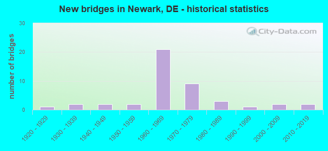
- New bridges - historical statistics
- 11920-1929
- 21930-1939
- 21940-1949
- 21950-1959
- 211960-1969
- 91970-1979
- 31980-1989
- 11990-1999
- 22000-2009
- 22010-2019
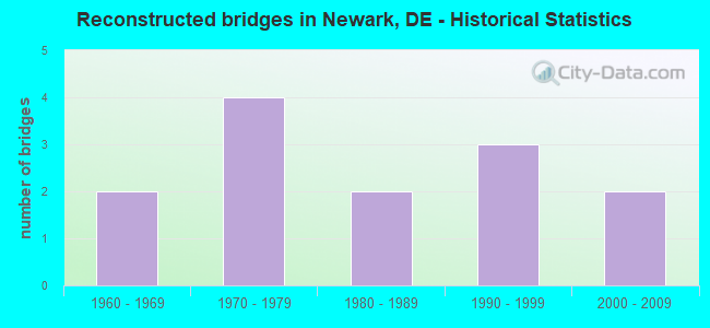
- Reconstructed bridges - Historical Statistics
- 21960-1969
- 41970-1979
- 21980-1989
- 31990-1999
- 22000-2009
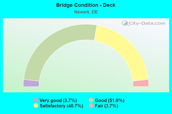
- Bridge Condition - Deck
- 3.7%Very good
- 51.9%Good
- 40.7%Satisfactory
- 3.7%Fair
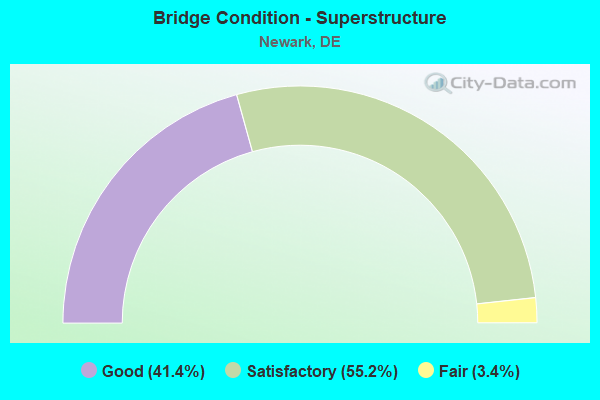
- Bridge Condition - Superstructure
- 41.4%Good
- 55.2%Satisfactory
- 3.4%Fair
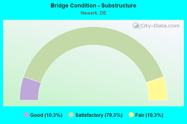
- Bridge Condition - Substructure
- 10.3%Good
- 79.3%Satisfactory
- 10.3%Fair
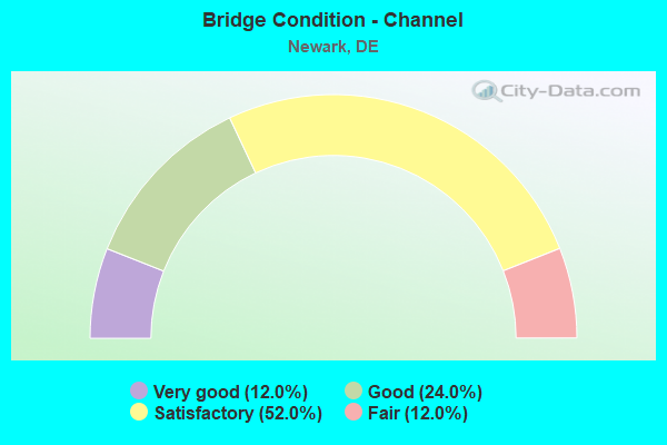
- Bridge Condition - Channel
- 12.0%Very good
- 24.0%Good
- 52.0%Satisfactory
- 12.0%Fair
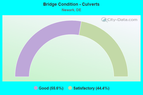
- Bridge Condition - Culverts
- 55.6%Good
- 44.4%Satisfactory
Find on map >> Show street view
Structure Number: 1641 387, Location: NEWARK (Lat: 39.670119, Lng: -75.753039), Route carried "under" structure: City street , Year Built: 1936, Structure Length: 0. m, Average Daily Traffic: 99 (year 2017), Truck Traffic: 5%, Features Intersected: AMTRAK & CONRAIL, Facility Carried by Structure: S. COLLEGE AVE
Minimum Vertical Clearance: 4.71m (15.45ft), Kilometerpoint: 0.000, Lanes on structure: 2, Lanes under structure: 2, Material/Design: Steel, Design/Construction: Stringer/Multi-beam, Length of Maximum Span: 24.9m (81.7ft)
Find on map >> Show street view
Structure Number: 1702 367, Location: SOUTH OF NEWARK (Lat: 39.646675, Lng: -75.758833), Route carried "under" structure: Interstate 95, Year Built: 1962, Structure Length: 0. m, Average Daily Traffic: 81,239 (year 2019), Truck Traffic: 8%, Features Intersected: I 95 / JFK MEM HGWY, Facility Carried by Structure: WELSH TRACT RD
Minimum Vertical Clearance: 5.70m (18.70ft), Kilometerpoint: 2.640, Lanes on structure: 2, Lanes under structure: 8, Toll: On toll road, Material/Design: Steel, Design/Construction: Stringer/Multi-beam, Length of Maximum Span: 26.1m (85.6ft)
Find on map >> Show street view
Structure Number: 1703 387, Location: SOUTH OF NEWARK (Lat: 39.646906, Lng: -75.746011), Route carried "under" structure: Interstate 95, Year Built: 1963, Structure Length: 0. m, Average Daily Traffic: 127,257 (year 2019), Truck Traffic: 15%, Features Intersected: I 95 / JFK MEM HGWY, Facility Carried by Structure: S. COLLEGE AVE. NB
Minimum Vertical Clearance: 5.18m (16.99ft), Kilometerpoint: 3.780, Lanes on structure: 2, Lanes under structure: 10, Material/Design: Steel, Design/Construction: Stringer/Multi-beam, Length of Maximum Span: 33.1m (108.6ft)
Find on map >> Show street view
Structure Number: 1703A387, Location: SOUTH OF NEWARK (Lat: 39.646903, Lng: -75.746247), Route carried "under" structure: Interstate 95, Year Built: 1970, Structure Length: 0. m, Average Daily Traffic: 127,257 (year 2019), Truck Traffic: 15%, Features Intersected: I 95, DELAWARE TURNPIKE, Facility Carried by Structure: S. COLLEGE AVE. SB
Minimum Vertical Clearance: 5.29m (17.36ft), Kilometerpoint: 3.780, Lanes on structure: 3, Lanes under structure: 10, Material/Design: Steel, Design/Construction: Stringer/Multi-beam, Length of Maximum Span: 33.1m (108.6ft)
Find on map >> Show street view
Structure Number: 1708 056, Location: SOUTH OF NEWARK (Lat: 39.648922, Lng: -75.732078), Route carried "under" structure: State highway 72, Year Built: 1963, Structure Length: 0. m, Average Daily Traffic: 30,913 (year 2017), Truck Traffic: 6%, Features Intersected: SR72, Facility Carried by Structure: JFK MEM HGY/I95 SB
Minimum Vertical Clearance: 5.95m (19.52ft), Kilometerpoint: 11.040, Lanes on structure: 4, Lanes under structure: 4, Material/Design: Steel, Design/Construction: Stringer/Multi-beam, Length of Maximum Span: 19.2m (63.0ft)
Find on map >> Show street view
Structure Number: 1709 056, Location: SOUTH OF NEWARK (Lat: 39.648681, Lng: -75.732008), Route carried "under" structure: State highway 72, Year Built: 1963, Structure Length: 0. m, Average Daily Traffic: 30,128 (year 2017), Truck Traffic: 6%, Features Intersected: SR 72/S. CHAPER ST., Facility Carried by Structure: I95 NB/JFK MEM HGY
Minimum Vertical Clearance: 5.96m (19.55ft), Kilometerpoint: 11.040, Lanes on structure: 4, Lanes under structure: 4, Material/Design: Steel, Design/Construction: Stringer/Multi-beam, Length of Maximum Span: 18.3m (60.0ft)
Find on map >> Show street view
Structure Number: 1711 348, Location: EAST OF NEWARK (Lat: 39.658550, Lng: -75.696872), Route carried "under" structure: Interstate 56, Year Built: 1963, Structure Length: 0. m, Average Daily Traffic: 101,169 (year 2020), Truck Traffic: 6%, Features Intersected: I 95 / JFK MEM HGWY, Facility Carried by Structure: SALEM CHURCH RD
Minimum Vertical Clearance: 30.48m (100.00ft), Kilometerpoint: 8.208, Lanes on structure: 2, Lanes under structure: 10, Toll: On toll road, Material/Design: Steel, Design/Construction: Stringer/Multi-beam, Length of Maximum Span: 43.7m (143.4ft)