Bridge Statistics for Newington, Virginia (VA)
Condition, Traffic, Stress, Structural Evaluation, Project Costs
- National Bridge Inventory (NBI) Statistics
- 59Number of bridges
- 745ft / 227mTotal length
- $108,140,000Total costs
- 1,737,890Total average daily traffic
- 86,913Total average daily truck traffic
- National Bridge Inventory (NBI) Registered Bridges for Newington
- No street view available for this location
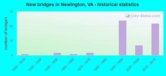
- New bridges - historical statistics
- 11930-1939
- 21950-1959
- 11960-1969
- 21970-1979
- 241990-1999
- 72000-2009
- 222010-2019
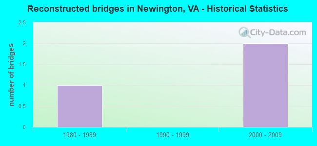
- Reconstructed bridges - Historical Statistics
- 11980-1989
- 01990-1999
- 22000-2009
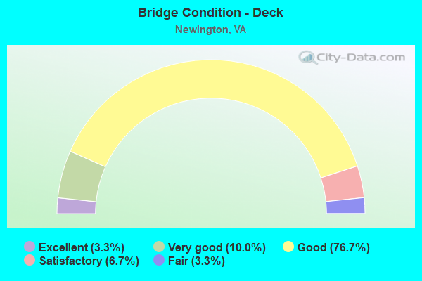
- Bridge Condition - Deck
- 3.3%Excellent
- 10.0%Very good
- 76.7%Good
- 6.7%Satisfactory
- 3.3%Fair
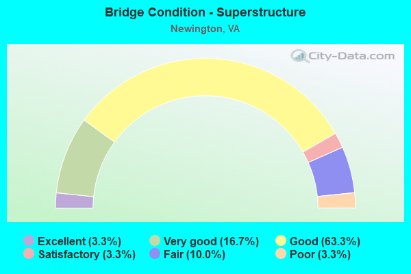
- Bridge Condition - Superstructure
- 3.3%Excellent
- 16.7%Very good
- 63.3%Good
- 3.3%Satisfactory
- 10.0%Fair
- 3.3%Poor
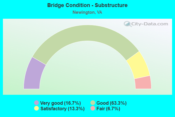
- Bridge Condition - Substructure
- 16.7%Very good
- 63.3%Good
- 13.3%Satisfactory
- 6.7%Fair

- Bridge Condition - Channel
- 19.0%Very good
- 38.1%Good
- 23.8%Satisfactory
- 19.0%Fair
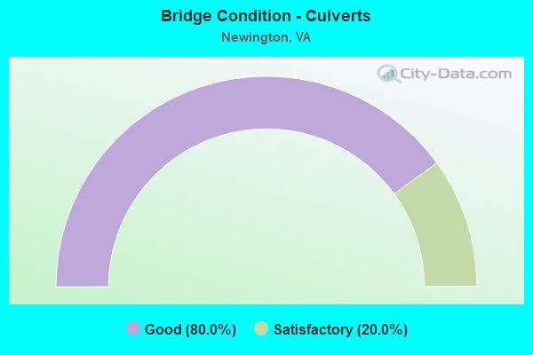
- Bridge Condition - Culverts
- 80.0%Good
- 20.0%Satisfactory
Find on map >> Show street view
Structure Number: 6429, Location: 01.76 642 / 01.30 617 (Lat: 38.724433, Lng: -77.204111), Route carried "on" structure: Interstate 95, Year Built: 1993, Status: Open, Structure Length: 4.94m (16.21ft), Average Daily Traffic: 216,051 (year 2020), Truck Traffic: 8%, Average Future Daily Traffic: 300,578 (year 2040), Design Load: HS 20, Features Intersected: ACCOTINK CREEK, Facility Carried by Structure: SHIRLEY MEM. HIWAY
Minimum Vertical Clearance: 30+ m (98+ ft), Kilometerpoint: 266.885, Lanes on structure: 4, Base Highway Network: Yes, Owner: State Highway Agency, Approaching Roadway Width: 16.5m (54.1ft), Skew: 34 degrees, Material/Design: Steel continuous, Design/Construction: Stringer/Multi-beam, Number Of Spans In Main Unit: 2, Length of Maximum Span: 24.1m (79.1ft), Curb-To-Curb Width: 54.6m (179.1ft), Out-to-Out Width: 60.1m (197.2ft)
Condition: Deck: Satisfactory, Superstructure: Satisfactory, Substructure: Satisfactory, Channel: Fair, Operating Rating: 49.0 metric tons, Method Used To Determine Operating Rating: Load and Resistance Factor (LRFR), Inventory Rating: 37.2 metric tons, Method Used To Determine Inventory Rating: Load and Resistance Factor (LRFR), Structural Evaluation: Equal to present minimum criteria, Deck Geometry: Superior to present desirable criteria, Waterway Adequacy: Equal to present desirable criteria, Approach Roadway Alignment: Equal to present desirable criteria, Length Of Structure Improvement: 3.05m (10.01ft), Designated Inspection Frequency: Every 24 months, Inspection Date: November 2021, Bridge Improvement Cost: $50,000,000, Roadway Improvement Cost: $50,000,000, Total Project Cost: $101,000,000, Deck Structure Type: Concrete Cast-file-Place
Find on map >> Show street view
Structure Number: 6739, Location: 00.06FR877/00.28TO3001 (Lat: 38.734481, Lng: -77.183503), Route carried "on" structure: County highway 637, Year Built: 1932, Year Reconstructed: 1986, Status: Open, Structure Length: 0.82m (2.69ft), Average Daily Traffic: 4,288 (year 2020), Truck Traffic: 1%, Average Future Daily Traffic: 4,717 (year 2040), Design Load: HS 20, Features Intersected: LONG BRANCH, Facility Carried by Structure: NEWINGTON ROAD
Minimum Vertical Clearance: 30+ m (98+ ft), Kilometerpoint: 2.542, Lanes on structure: 2, Owner: State Highway Agency, Approaching Roadway Width: 7.6m (24.9ft), Material/Design: Prestressed concrete, Design/Construction: Slab, Number Of Spans In Main Unit: 1, Length of Maximum Span: 8.2m (26.9ft), Curb or Sidewalk Widths: Left: 0.3m (1.0ft), Right: 0.3m (1.0ft), Curb-To-Curb Width: 7.3m (24.0ft), Out-to-Out Width: 8.2m (26.9ft)
Condition: Deck: Good, Superstructure: Good, Substructure: Good, Channel: Satisfactory, Operating Rating: 71.4 metric tons, Method Used To Determine Operating Rating: Load and Resistance Factor (LRFR), Inventory Rating: 54.6 metric tons, Method Used To Determine Inventory Rating: Load and Resistance Factor (LRFR), Structural Evaluation: Better than present minimum criteria, Deck Geometry: High priority of replacement, Waterway Adequacy: Equal to present minimum criteria, Approach Roadway Alignment: Equal to present desirable criteria, Length Of Structure Improvement: 0.82m (2.69ft), Designated Inspection Frequency: Every 24 months, Inspection Date: July 2021, Bridge Improvement Cost: $25,000, Roadway Improvement Cost: $3,000, Total Project Cost: $30,000 ( Estimate for 2015), Deck Structure Type: Concrete Cast-file-Place, Wearing Surface/Protective System: Wearing Surface: Bituminous
Find on map >> Show street view
Structure Number: 6899, Location: 00.50FR638/01.50TO617 (Lat: 38.728614, Lng: -77.202967), Route carried "on" structure: County highway 790, Year Built: 1950, Status: Open, Structure Length: 2.35m (7.71ft), Average Daily Traffic: 10,714 (year 2020), Truck Traffic: 2%, Average Future Daily Traffic: 11,448 (year 2040), Design Load: HS 20, Features Intersected: ACCOTINK CREEK, Facility Carried by Structure: ALBAN ROAD
Minimum Vertical Clearance: 30+ m (98+ ft), Kilometerpoint: 0.965, Lanes on structure: 2, Owner: State Highway Agency, Approaching Roadway Width: 9.8m (32.2ft), Material/Design: Concrete, Design/Construction: Stringer/Multi-beam, Number Of Spans In Main Unit: 2, Length of Maximum Span: 11.9m (39.0ft), Curb or Sidewalk Widths: Left: 0.5m (1.6ft), Right: 0.5m (1.6ft), Curb-To-Curb Width: 7.3m (24.0ft), Out-to-Out Width: 7.8m (25.6ft)
Condition: Deck: Fair, Superstructure: Poor, Substructure: Fair, Channel: Fair, Operating Rating: 41.7 metric tons, Method Used To Determine Operating Rating: Load and Resistance Factor (LRFR), Inventory Rating: 32.7 metric tons, Method Used To Determine Inventory Rating: Load and Resistance Factor (LRFR), Structural Evaluation: Meets minimum limits, Deck Geometry: High priority of replacement, Waterway Adequacy: Somewhat better than minimum adequacy, Approach Roadway Alignment: Somewhat better than minimum adequacy, Length Of Structure Improvement: 2.38m (7.81ft), Designated Inspection Frequency: Every 24 months, Other Special Inspection Frequency: Every 12 months, Inspection Date: July 2021, Other Special Inspection Date: July 2021, Bridge Improvement Cost: $1,000, Roadway Improvement Cost: $1,000, Total Project Cost: $3,000, Deck Structure Type: Concrete Cast-file-Place, Wearing Surface/Protective System: Wearing Surface: Latex Concrete
Find on map >> Show street view
Structure Number: 6996, Location: 00.11FR6800/00.12TO4502 (Lat: 38.741000, Lng: -77.196000), Route carried "on" structure: County highway 4502, Year Built: 1976, Status: Open, Structure Length: 5.55m (18.21ft), Average Daily Traffic: 3,150 (year 2020), Average Future Daily Traffic: 3,466 (year 2040), Design Load: HS 20, Features Intersected: ACCOTINK CREEK, Facility Carried by Structure: FULLERTON ROAD EB
Minimum Vertical Clearance: 30+ m (98+ ft), Kilometerpoint: 1.297, Lanes on structure: 2, Owner: State Highway Agency, Approaching Roadway Width: 15.2m (49.9ft), Material/Design: Steel, Design/Construction: Stringer/Multi-beam, Number Of Spans In Main Unit: 3, Length of Maximum Span: 18.6m (61.0ft), Curb or Sidewalk Widths: Left: 0.2m (0.7ft), Right: 0.2m (0.7ft), Curb-To-Curb Width: 9.1m (29.9ft), Out-to-Out Width: 10.1m (33.1ft)
Condition: Deck: Satisfactory, Superstructure: Fair, Substructure: Fair, Channel: Good, Operating Rating: 62.7 metric tons, Method Used To Determine Operating Rating: Load and Resistance Factor (LRFR), Inventory Rating: 48.4 metric tons, Method Used To Determine Inventory Rating: Load and Resistance Factor (LRFR), Structural Evaluation: Somewhat better than minimum adequacy, Deck Geometry: Meets minimum limits, Waterway Adequacy: Better than present minimum criteria, Approach Roadway Alignment: Better than present minimum criteria, Length Of Structure Improvement: 5.55m (18.21ft), Designated Inspection Frequency: Every 24 months, Inspection Date: December 2020, Bridge Improvement Cost: $88,000, Roadway Improvement Cost: $99,000, Total Project Cost: $400,000 ( Estimate for 2014), Deck Structure Type: Concrete Cast-file-Place, Wearing Surface/Protective System: Wearing Surface: Latex Concrete
Find on map >> Show street view
Structure Number: 23458, Location: 01.38FR638/00.65TO636 (Lat: 38.751639, Lng: -77.241694), Route carried "on" structure: County highway 286, Year Built: 1992, Status: Open, Structure Length: 7.22m (23.69ft), Average Daily Traffic: 19,848 (year 2020), Truck Traffic: 1%, Average Future Daily Traffic: 27,787 (year 2040), Design Load: HS 20, Features Intersected: MIDDLE RUN CREEK
Minimum Vertical Clearance: 30+ m (98+ ft), Kilometerpoint: 0.000, Lanes on structure: 2, Base Highway Network: Yes, Owner: State Highway Agency, Approaching Roadway Width: 12.2m (40.0ft), Skew: 4 degrees, Material/Design: Steel continuous, Design/Construction: Stringer/Multi-beam, Number Of Spans In Main Unit: 3, Length of Maximum Span: 27.4m (89.9ft), Curb-To-Curb Width: 12.3m (40.4ft), Out-to-Out Width: 13.4m (44.0ft)
Condition: Deck: Good, Superstructure: Good, Substructure: Good, Channel: Satisfactory, Operating Rating: 53.5 metric tons, Method Used To Determine Operating Rating: Load and Resistance Factor (LRFR), Inventory Rating: 41.7 metric tons, Method Used To Determine Inventory Rating: Load and Resistance Factor (LRFR), Structural Evaluation: Better than present minimum criteria, Deck Geometry: Better than present minimum criteria, Waterway Adequacy: Equal to present desirable criteria, Approach Roadway Alignment: Equal to present desirable criteria, Length Of Structure Improvement: 7.22m (23.69ft), Designated Inspection Frequency: Every 24 months, Inspection Date: April 2020, Bridge Improvement Cost: $55,000, Roadway Improvement Cost: $82,000, Total Project Cost: $200,000 ( Estimate for 2014), Deck Structure Type: Concrete Cast-file-Place, Wearing Surface/Protective System: Wearing Surface: Monolithic Concrete, Deck Protection: Epoxy Coated Reinforcing
Find on map >> Show street view
Structure Number: 23459, Location: 01.38FR638/00.68TO636 (Lat: 38.751889, Lng: -77.241147), Route carried "on" structure: County highway 286, Year Built: 1992, Status: Open, Structure Length: 7.22m (23.69ft), Average Daily Traffic: 19,848 (year 2020), Truck Traffic: 1%, Average Future Daily Traffic: 27,787 (year 2040), Design Load: HS 20+Mod, Features Intersected: MIDDLE RUN CREEK, Facility Carried by Structure: FAIRFAX CO. PKWY.
Minimum Vertical Clearance: 30+ m (98+ ft), Kilometerpoint: 0.000, Lanes on structure: 2, Base Highway Network: Yes, Owner: State Highway Agency, Approaching Roadway Width: 12.2m (40.0ft), Skew: 4 degrees, Material/Design: Steel continuous, Design/Construction: Stringer/Multi-beam, Number Of Spans In Main Unit: 3, Length of Maximum Span: 27.4m (89.9ft), Curb or Sidewalk Widths: Left: 0.0m, Right: 3.0m (9.8ft), Curb-To-Curb Width: 12.3m (40.4ft), Out-to-Out Width: 16.6m (54.5ft)
Condition: Deck: Good, Superstructure: Good, Substructure: Good, Channel: Satisfactory, Operating Rating: 52.6 metric tons, Method Used To Determine Operating Rating: Load and Resistance Factor (LRFR), Inventory Rating: 39.9 metric tons, Method Used To Determine Inventory Rating: Load and Resistance Factor (LRFR), Structural Evaluation: Better than present minimum criteria, Deck Geometry: Better than present minimum criteria, Waterway Adequacy: Equal to present desirable criteria, Approach Roadway Alignment: Equal to present desirable criteria, Length Of Structure Improvement: 0.30m (0.98ft), Designated Inspection Frequency: Every 24 months, Inspection Date: April 2020, Bridge Improvement Cost: $1,000, Roadway Improvement Cost: $1,000, Total Project Cost: $3,000 ( Estimate for 2014), Deck Structure Type: Concrete Cast-file-Place, Wearing Surface/Protective System: Wearing Surface: Monolithic Concrete, Deck Protection: Epoxy Coated Reinforcing
Find on map >> Show street view
Structure Number: 23612, Location: 00.20FR95/00.06TO7100 (Lat: 38.743289, Lng: -77.189628), Route carried "on" structure: Ramp Interstate 95, Year Built: 1993, Status: Open, Structure Length: 7.71m (25.30ft), Average Daily Traffic: 4,019 (year 2020), Average Future Daily Traffic: 5,627 (year 2040), Design Load: HS 20, Features Intersected: ALBAN-BACKLICK & RAMP GG
Minimum Vertical Clearance: 30+ m (98+ ft), Kilometerpoint: 0.000, Lanes on structure: 1, Lanes under structure: 6, Base Highway Network: Yes, Owner: State Highway Agency, Approaching Roadway Width: 9.1m (29.9ft), Skew: 4 degrees, Material/Design: Steel, Design/Construction: Stringer/Multi-beam, Number Of Spans In Main Unit: 2, Length of Maximum Span: 42.7m (140.1ft), Curb-To-Curb Width: 9.1m (29.9ft), Out-to-Out Width: 10.1m (33.1ft)
Condition: Deck: Good, Superstructure: Good, Substructure: Good, Operating Rating: 55.4 metric tons, Method Used To Determine Operating Rating: Load and Resistance Factor (LRFR), Inventory Rating: 42.7 metric tons, Method Used To Determine Inventory Rating: Load and Resistance Factor (LRFR), Structural Evaluation: Better than present minimum criteria, Deck Geometry: Superior to present desirable criteria, Underclear: High priority of corrective action, Approach Roadway Alignment: Equal to present desirable criteria, Length Of Structure Improvement: 7.71m (25.30ft), Designated Inspection Frequency: Every 24 months, Inspection Date: December 2020, Bridge Improvement Cost: $150,000, Roadway Improvement Cost: $300,000, Total Project Cost: $1,000,000 ( Estimate for 2014), Deck Structure Type: Concrete Cast-file-Place, Wearing Surface/Protective System: Wearing Surface: Monolithic Concrete, Deck Protection: Epoxy Coated Reinforcing
Find on map >> Show street view
Structure Number: 23619, Location: .20 FULLERTON RD/.16 I-95 (Lat: 38.742094, Lng: -77.190767), Route carried "on" structure: County highway 286, Year Built: 1993, Status: Open, Structure Length: 3.54m (11.61ft), Average Daily Traffic: 45,758 (year 2020), Truck Traffic: 1%, Average Future Daily Traffic: 54,270 (year 2040), Design Load: HS 20, Features Intersected: ALBAN-BACKLICK CONNECTOR, Facility Carried by Structure: FAIRFAX CNTY PKWY
Minimum Vertical Clearance: 30+ m (98+ ft), Kilometerpoint: 0.000, Lanes on structure: 6, Lanes under structure: 4, Base Highway Network: Yes, Owner: State Highway Agency, Approaching Roadway Width: 29.0m (95.1ft), Skew: 23 degrees, Material/Design: Steel, Design/Construction: Stringer/Multi-beam, Number Of Spans In Main Unit: 1, Length of Maximum Span: 35.4m (116.1ft), Curb-To-Curb Width: 29.0m (95.1ft), Out-to-Out Width: 34.1m (111.9ft)
Condition: Deck: Good, Superstructure: Good, Substructure: Satisfactory, Operating Rating: 44.7 metric tons, Method Used To Determine Operating Rating: Load and Resistance Factor (LRFR), Inventory Rating: 34.5 metric tons, Method Used To Determine Inventory Rating: Load and Resistance Factor (LRFR), Structural Evaluation: Equal to present minimum criteria, Deck Geometry: Superior to present desirable criteria, Underclear: Meets minimum limits, Approach Roadway Alignment: Better than present minimum criteria, Length Of Structure Improvement: 3.54m (11.61ft), Designated Inspection Frequency: Every 24 months, Inspection Date: November 2021, Bridge Improvement Cost: $100,000, Roadway Improvement Cost: $500,000, Total Project Cost: $1,000,000, Deck Structure Type: Concrete Cast-file-Place, Wearing Surface/Protective System: Wearing Surface: Monolithic Concrete, Deck Protection: Epoxy Coated Reinforcing
Find on map >> Show street view
Structure Number: 23722, Location: 00.16 3302 / 00.08 641 (Lat: 38.720256, Lng: -77.208097), Route carried "on" structure: County highway 638, Year Built: 1993, Status: Open, Structure Length: 14.48m (47.51ft), Average Daily Traffic: 9,133 (year 2020), Truck Traffic: 2%, Average Future Daily Traffic: 10,046 (year 2040), Design Load: HS 20, Features Intersected: R.F. & P. RR AND I-95, Facility Carried by Structure: POHICK ROAD
Minimum Vertical Clearance: 30+ m (98+ ft), Kilometerpoint: 2.365, Lanes on structure: 4, Lanes under structure: 11, Owner: State Highway Agency, Approaching Roadway Width: 15.8m (51.8ft), Skew: 23 degrees, Material/Design: Steel continuous, Design/Construction: Stringer/Multi-beam, Number Of Spans In Main Unit: 3, Length of Maximum Span: 51.5m (169.0ft), Curb or Sidewalk Widths: Left: 0.0m, Right: 3.0m (9.8ft), Curb-To-Curb Width: 16.5m (54.1ft), Out-to-Out Width: 25.6m (84.0ft)
Condition: Deck: Good, Superstructure: Good, Substructure: Good, Operating Rating: 49.7 metric tons, Method Used To Determine Operating Rating: Load and Resistance Factor (LRFR), Inventory Rating: 38.4 metric tons, Method Used To Determine Inventory Rating: Load and Resistance Factor (LRFR), Structural Evaluation: Better than present minimum criteria, Deck Geometry: Meets minimum limits, Underclear: Equal to present minimum criteria, Approach Roadway Alignment: Equal to present desirable criteria, Length Of Structure Improvement: 8.69m (28.51ft), Designated Inspection Frequency: Every 24 months, Inspection Date: October 2021, Bridge Improvement Cost: $20,000, Roadway Improvement Cost: $20,000, Total Project Cost: $500,000, Deck Structure Type: Concrete Cast-file-Place, Wearing Surface/Protective System: Wearing Surface: Monolithic Concrete, Deck Protection: Epoxy Coated Reinforcing
Find on map >> Show street view
Structure Number: 24732, Location: 00.85FR617/00.45TO611 (Lat: 38.729650, Lng: -77.188697), Route carried "on" structure: County highway 286, Year Built: 1996, Status: Open, Structure Length: 5.64m (18.50ft), Average Daily Traffic: 15,655 (year 2020), Truck Traffic: 3%, Average Future Daily Traffic: 21,918 (year 2040), Design Load: HS 20, Features Intersected: CSX RAILWAY, Facility Carried by Structure: FAIRFAX CO. PKWY.
Minimum Vertical Clearance: 30+ m (98+ ft), Kilometerpoint: 0.000, Lanes on structure: 3, Base Highway Network: Yes, Owner: State Highway Agency, Approaching Roadway Width: 15.8m (51.8ft), Skew: 2 degrees, Material/Design: Steel, Design/Construction: Stringer/Multi-beam, Number Of Spans In Main Unit: 3, Length of Maximum Span: 29.0m (95.1ft), Curb-To-Curb Width: 16.2m (53.1ft), Out-to-Out Width: 17.1m (56.1ft)
Condition: Deck: Good, Superstructure: Good, Substructure: Good, Operating Rating: 57.0 metric tons, Method Used To Determine Operating Rating: Load and Resistance Factor (LRFR), Inventory Rating: 43.9 metric tons, Method Used To Determine Inventory Rating: Load and Resistance Factor (LRFR), Structural Evaluation: Better than present minimum criteria, Deck Geometry: Better than present minimum criteria, Underclear: Superior to present desirable criteria, Approach Roadway Alignment: Equal to present desirable criteria, Length Of Structure Improvement: 5.64m (18.50ft), Designated Inspection Frequency: Every 24 months, Inspection Date: December 2020, Bridge Improvement Cost: $67,000, Roadway Improvement Cost: $99,000, Total Project Cost: $200,000, Deck Structure Type: Concrete Cast-file-Place, Wearing Surface/Protective System: Wearing Surface: Monolithic Concrete, Deck Protection: Epoxy Coated Reinforcing
Find on map >> Show street view
Structure Number: 24734, Location: 00.60FR95/00.40TO611 (Lat: 38.729478, Lng: -77.188869), Route carried "on" structure: County highway 286, Year Built: 1996, Status: Open, Structure Length: 5.64m (18.50ft), Average Daily Traffic: 15,655 (year 2020), Truck Traffic: 3%, Average Future Daily Traffic: 21,918 (year 2040), Design Load: HS 20, Features Intersected: CSX RAILWAY, Facility Carried by Structure: FAIRFAX CO & PKWY.
Minimum Vertical Clearance: 30+ m (98+ ft), Kilometerpoint: 0.000, Lanes on structure: 2, Owner: State Highway Agency, Approaching Roadway Width: 12.2m (40.0ft), Skew: 1 degrees, Material/Design: Steel, Design/Construction: Stringer/Multi-beam, Number Of Spans In Main Unit: 3, Length of Maximum Span: 29.0m (95.1ft), Curb-To-Curb Width: 12.5m (41.0ft), Out-to-Out Width: 13.4m (44.0ft)
Condition: Deck: Good, Superstructure: Good, Substructure: Good, Operating Rating: 60.4 metric tons, Method Used To Determine Operating Rating: Load and Resistance Factor (LRFR), Inventory Rating: 46.6 metric tons, Method Used To Determine Inventory Rating: Load and Resistance Factor (LRFR), Structural Evaluation: Better than present minimum criteria, Deck Geometry: Better than present minimum criteria, Underclear: Somewhat better than minimum adequacy, Approach Roadway Alignment: Equal to present desirable criteria, Length Of Structure Improvement: 5.64m (18.50ft), Designated Inspection Frequency: Every 24 months, Inspection Date: December 2020, Bridge Improvement Cost: $67,000, Roadway Improvement Cost: $150,000, Total Project Cost: $300,000, Deck Structure Type: Concrete Cast-file-Place, Wearing Surface/Protective System: Wearing Surface: Monolithic Concrete, Deck Protection: Epoxy Coated Reinforcing
Find on map >> Show street view
Structure Number: 24886, Location: 01.00FR617/00.30TO611 (Lat: 38.727633, Lng: -77.186942), Route carried "on" structure: County highway 286, Year Built: 1997, Status: Open, Structure Length: 4.88m (16.01ft), Average Daily Traffic: 15,655 (year 2020), Truck Traffic: 3%, Average Future Daily Traffic: 21,918 (year 2040), Design Load: HS 20, Features Intersected: RTE.877-CINDER BED ROAD, Facility Carried by Structure: FAIRFAX CO.PKWY.SB
Minimum Vertical Clearance: 30+ m (98+ ft), Kilometerpoint: 0.000, Lanes on structure: 2, Lanes under structure: 3, Base Highway Network: Yes, Owner: State Highway Agency, Approaching Roadway Width: 14.6m (47.9ft), Material/Design: Concrete, Design/Construction: Stringer/Multi-beam, Number Of Spans In Main Unit: 3, Length of Maximum Span: 22.9m (75.1ft), Curb-To-Curb Width: 14.6m (47.9ft), Out-to-Out Width: 15.6m (51.2ft)
Condition: Deck: Good, Superstructure: Good, Substructure: Good, Operating Rating: 80.7 metric tons, Method Used To Determine Operating Rating: Load and Resistance Factor (LRFR), Inventory Rating: 60.5 metric tons, Method Used To Determine Inventory Rating: Load and Resistance Factor (LRFR), Structural Evaluation: Better than present minimum criteria, Deck Geometry: Superior to present desirable criteria, Underclear: Somewhat better than minimum adequacy, Approach Roadway Alignment: Equal to present desirable criteria, Length Of Structure Improvement: 4.88m (16.01ft), Designated Inspection Frequency: Every 24 months, Inspection Date: October 2021, Bridge Improvement Cost: $15,000, Roadway Improvement Cost: $15,000, Total Project Cost: $50,000, Deck Structure Type: Concrete Cast-file-Place, Wearing Surface/Protective System: Wearing Surface: Monolithic Concrete, Deck Protection: Epoxy Coated Reinforcing
Find on map >> Show street view
Structure Number: 24887, Location: 01.11FR617/00.30TO611 (Lat: 38.727764, Lng: -77.186764), Route carried "on" structure: County highway 286, Year Built: 1997, Status: Open, Structure Length: 4.88m (16.01ft), Average Daily Traffic: 15,655 (year 2020), Truck Traffic: 3%, Average Future Daily Traffic: 21,918 (year 2040), Design Load: HS 20, Features Intersected: RTE. 877-CINDER BED ROAD, Facility Carried by Structure: FX.COUNTY PKWY NB
Minimum Vertical Clearance: 30+ m (98+ ft), Kilometerpoint: 0.000, Lanes on structure: 3, Lanes under structure: 3, Base Highway Network: Yes, Owner: State Highway Agency, Approaching Roadway Width: 14.6m (47.9ft), Material/Design: Concrete, Design/Construction: Stringer/Multi-beam, Number Of Spans In Main Unit: 3, Length of Maximum Span: 22.9m (75.1ft), Curb-To-Curb Width: 14.6m (47.9ft), Out-to-Out Width: 15.6m (51.2ft)
Condition: Deck: Good, Superstructure: Good, Substructure: Good, Operating Rating: 86.5 metric tons, Method Used To Determine Operating Rating: Load and Resistance Factor (LRFR), Inventory Rating: 61.6 metric tons, Method Used To Determine Inventory Rating: Load and Resistance Factor (LRFR), Structural Evaluation: Better than present minimum criteria, Deck Geometry: Somewhat better than minimum adequacy, Underclear: Somewhat better than minimum adequacy, Approach Roadway Alignment: Equal to present desirable criteria, Length Of Structure Improvement: 4.88m (16.01ft), Designated Inspection Frequency: Every 24 months, Inspection Date: October 2021, Bridge Improvement Cost: $10,000, Roadway Improvement Cost: $15,000, Total Project Cost: $50,000, Deck Structure Type: Concrete Cast-file-Place, Wearing Surface/Protective System: Wearing Surface: Monolithic Concrete, Deck Protection: Epoxy Coated Reinforcing
Find on map >> Show street view
Structure Number: 24935, Location: 01.3FR1/01.6TO613 (Lat: 38.724089, Lng: -77.183492), Route carried "on" structure: County highway 611, Year Built: 1997, Status: Open, Structure Length: 5.55m (18.21ft), Average Daily Traffic: 17,298 (year 2020), Truck Traffic: 4%, Average Future Daily Traffic: 24,217 (year 2040), Design Load: HS 20, Features Intersected: FAIRFAX CO.PKWY., Facility Carried by Structure: TELEGRAPH RD.
Minimum Vertical Clearance: 30+ m (98+ ft), Kilometerpoint: 14.915, Lanes on structure: 5, Lanes under structure: 4, Owner: State Highway Agency, Approaching Roadway Width: 25.6m (84.0ft), Skew: 30 degrees, Material/Design: Steel continuous, Design/Construction: Stringer/Multi-beam, Number Of Spans In Main Unit: 2, Length of Maximum Span: 27.7m (90.9ft), Curb or Sidewalk Widths: Left: 3.2m (10.5ft), Right: 1.7m (5.6ft), Curb-To-Curb Width: 25.6m (84.0ft), Out-to-Out Width: 33.1m (108.6ft)
Condition: Deck: Good, Superstructure: Good, Substructure: Good, Operating Rating: 53.9 metric tons, Method Used To Determine Operating Rating: Load and Resistance Factor (LRFR), Inventory Rating: 41.5 metric tons, Method Used To Determine Inventory Rating: Load and Resistance Factor (LRFR), Structural Evaluation: Better than present minimum criteria, Deck Geometry: Superior to present desirable criteria, Underclear: Equal to present minimum criteria, Approach Roadway Alignment: Equal to present desirable criteria, Length Of Structure Improvement: 5.55m (18.21ft), Designated Inspection Frequency: Every 24 months, Inspection Date: November 2021, Bridge Improvement Cost: $75,000, Roadway Improvement Cost: $75,000, Total Project Cost: $200,000, Deck Structure Type: Concrete Cast-file-Place, Wearing Surface/Protective System: Wearing Surface: Monolithic Concrete, Deck Protection: Epoxy Coated Reinforcing
Find on map >> Show street view
Structure Number: 24942, Location: 01.10FR617/00.20TO611 (Lat: 38.726708, Lng: -77.185583), Route carried "on" structure: County highway 286, Year Built: 1997, Status: Open, Structure Length: 1.10m (3.61ft), Average Daily Traffic: 31,311 (year 2020), Truck Traffic: 3%, Average Future Daily Traffic: 43,835 (year 2040), Design Load: HS 20, Features Intersected: LONG BRANCH CREEK, Facility Carried by Structure: FAIRFAX CO.PKWY.
Minimum Vertical Clearance: 30+ m (98+ ft), Kilometerpoint: 0.000, Lanes on structure: 6, Base Highway Network: Yes, Owner: State Highway Agency, Approaching Roadway Width: 28.3m (92.8ft), Skew: 4 degrees, Material/Design: Concrete, Design/Construction: Culvert, Number Of Spans In Main Unit: 2, Length of Maximum Span: 5.5m (18.0ft)
Condition: Channel: Good, Culverts: Good, Operating Rating: 89.8 metric tons, Method Used To Determine Operating Rating: Load Factor (LF), Inventory Rating: 89.8 metric tons, Method Used To Determine Inventory Rating: Load Factor (LF), Structural Evaluation: Better than present minimum criteria, Waterway Adequacy: Equal to present desirable criteria, Approach Roadway Alignment: Equal to present desirable criteria, Length Of Structure Improvement: 20.12m (66.01ft), Designated Inspection Frequency: Every 24 months, Inspection Date: July 2021, Bridge Improvement Cost: $55,000, Roadway Improvement Cost: $99,000, Total Project Cost: $200,000 ( Estimate for 2015)
Find on map >> Show street view
Structure Number: 25168, Location: 00.10FR286/00.98TO1 (Lat: 38.723081, Lng: -77.185456), Route carried "on" structure: County highway 611, Year Built: 2000, Status: Open, Structure Length: 0.98m (3.22ft), Average Daily Traffic: 17,298 (year 2020), Truck Traffic: 2%, Average Future Daily Traffic: 24,217 (year 2040), Design Load: HS 20, Features Intersected: LONG BRANCH______#6514, Facility Carried by Structure: TELEGRAPH ROAD
Minimum Vertical Clearance: 30+ m (98+ ft), Kilometerpoint: 0.000, Lanes on structure: 4, Owner: State Highway Agency, Approaching Roadway Width: 15.2m (49.9ft), Skew: 10 degrees, Material/Design: Concrete, Design/Construction: Culvert, Number Of Spans In Main Unit: 3, Length of Maximum Span: 3.0m (9.8ft)
Condition: Channel: Satisfactory, Culverts: Satisfactory, Operating Rating: 89.8 metric tons, Method Used To Determine Operating Rating: Load Factor (LF), Inventory Rating: 78.0 metric tons, Method Used To Determine Inventory Rating: Load Factor (LF), Structural Evaluation: Equal to present minimum criteria, Waterway Adequacy: Equal to present desirable criteria, Approach Roadway Alignment: Equal to present desirable criteria, Length Of Structure Improvement: 12.01m (39.40ft), Designated Inspection Frequency: Every 24 months, Inspection Date: March 2020, Bridge Improvement Cost: $35,000, Roadway Improvement Cost: $75,000, Total Project Cost: $150,000
Find on map >> Show street view
Structure Number: 25176, Location: 00.85FR0001/00.25TO7100 (Lat: 38.720217, Lng: -77.190914), Route carried "on" structure: County highway 611, Year Built: 2001, Status: Open, Structure Length: 7.44m (24.41ft), Average Daily Traffic: 17,298 (year 2020), Truck Traffic: 1%, Average Future Daily Traffic: 24,217 (year 2040), Design Load: HS 20+Mod, Features Intersected: ACCOTINK CREEK, Facility Carried by Structure: TELEGRAPH ROAD SB
Minimum Vertical Clearance: 30+ m (98+ ft), Kilometerpoint: 14.368, Lanes on structure: 2, Owner: State Highway Agency, Approaching Roadway Width: 11.0m (36.1ft), Skew: 3 degrees, Material/Design: Steel continuous, Design/Construction: Stringer/Multi-beam, Number Of Spans In Main Unit: 3, Length of Maximum Span: 24.7m (81.0ft), Curb-To-Curb Width: 11.0m (36.1ft), Out-to-Out Width: 14.6m (47.9ft)
Condition: Deck: Good, Superstructure: Good, Substructure: Good, Channel: Good, Operating Rating: 64.4 metric tons, Method Used To Determine Operating Rating: Load and Resistance Factor (LRFR), Inventory Rating: 49.9 metric tons, Method Used To Determine Inventory Rating: Load and Resistance Factor (LRFR), Structural Evaluation: Better than present minimum criteria, Deck Geometry: Meets minimum limits, Waterway Adequacy: Equal to present desirable criteria, Approach Roadway Alignment: Equal to present desirable criteria, Length Of Structure Improvement: 2.80m (9.19ft), Designated Inspection Frequency: Every 24 months, Inspection Date: Febuary 2022, Bridge Improvement Cost: $1,020,000, Roadway Improvement Cost: $130,000, Total Project Cost: $1,250,000, Deck Structure Type: Concrete Cast-file-Place, Wearing Surface/Protective System: Deck Protection: Epoxy Coated Reinforcing
Find on map >> Show street view
Structure Number: 25177, Location: 00.20FR286/00.98TO1 (Lat: 38.722994, Lng: -77.185692), Route carried "on" structure: County highway 611, Year Built: 1964, Year Reconstructed: 2000, Status: Open, Structure Length: 1.28m (4.20ft), Average Daily Traffic: 17,298 (year 2020), Truck Traffic: 2%, Average Future Daily Traffic: 24,217 (year 2040), Design Load: HS 20, Features Intersected: LONG BRANCH CREEK #6199, Facility Carried by Structure: TELEGRAPH ROAD
Minimum Vertical Clearance: 30+ m (98+ ft), Kilometerpoint: 0.000, Lanes on structure: 4, Owner: State Highway Agency, Approaching Roadway Width: 15.2m (49.9ft), Skew: 10 degrees, Material/Design: Concrete, Design/Construction: Culvert, Number Of Spans In Main Unit: 3, Length of Maximum Span: 4.0m (13.1ft)
Condition: Channel: Good, Culverts: Good, Operating Rating: 89.8 metric tons, Method Used To Determine Operating Rating: Load Factor (LF), Inventory Rating: 78.0 metric tons, Method Used To Determine Inventory Rating: Load Factor (LF), Structural Evaluation: Better than present minimum criteria, Waterway Adequacy: Equal to present desirable criteria, Approach Roadway Alignment: Equal to present desirable criteria, Length Of Structure Improvement: 15.30m (50.20ft), Designated Inspection Frequency: Every 24 months, Inspection Date: March 2020, Bridge Improvement Cost: $20,000, Roadway Improvement Cost: $35,000, Total Project Cost: $75,000
Find on map >> Show street view
Structure Number: 25724, Location: 00.25FR5280/00.25TO638 (Lat: 38.722800, Lng: -77.215000), Route carried "on" structure: County highway 641, Year Built: 2000, Status: Open, Structure Length: 7.07m (23.20ft), Average Daily Traffic: 6,185 (year 2020), Average Future Daily Traffic: 6,804 (year 2040), Design Load: HS 20, Features Intersected: POHICK CREEK, Facility Carried by Structure: POHICK ROAD
Minimum Vertical Clearance: 30+ m (98+ ft), Kilometerpoint: 24.183, Lanes on structure: 2, Owner: State Highway Agency, Approaching Roadway Width: 9.1m (29.9ft), Skew: 2 degrees, Material/Design: Steel continuous, Design/Construction: Stringer/Multi-beam, Number Of Spans In Main Unit: 2, Length of Maximum Span: 35.1m (115.2ft), Curb or Sidewalk Widths: Left: 0.0m, Right: 3.0m (9.8ft), Curb-To-Curb Width: 11.0m (36.1ft), Out-to-Out Width: 15.2m (49.9ft)
Condition: Deck: Good, Superstructure: Good, Substructure: Good, Channel: Satisfactory, Operating Rating: 73.1 metric tons, Method Used To Determine Operating Rating: Load and Resistance Factor (LRFR), Inventory Rating: 56.5 metric tons, Method Used To Determine Inventory Rating: Load and Resistance Factor (LRFR), Structural Evaluation: Better than present minimum criteria, Deck Geometry: Meets minimum limits, Waterway Adequacy: Better than present minimum criteria, Approach Roadway Alignment: Equal to present desirable criteria, Length Of Structure Improvement: 1.22m (4.00ft), Designated Inspection Frequency: Every 24 months, Inspection Date: October 2020, Bridge Improvement Cost: $100,000, Roadway Improvement Cost: $100,000, Total Project Cost: $220,000 ( Estimate for 2014), Deck Structure Type: Concrete Cast-file-Place, Wearing Surface/Protective System: Deck Protection: Epoxy Coated Reinforcing
Find on map >> Show street view
Structure Number: 26251, Location: NEWINGTON MAINT.HQTS.LOT (Lat: 38.731475, Lng: -77.184214), Route carried "on" structure: Other road , Year Built: 1955, Status: Open, Structure Length: 0.82m (2.69ft), Average Daily Traffic: 50 (year 2004), Truck Traffic: 75%, Average Future Daily Traffic: 60 (year 2032), Design Load: HS 20, Features Intersected: LONG BRANCH, Facility Carried by Structure: SALT DOME ACCESS
Minimum Vertical Clearance: 30+ m (98+ ft), Kilometerpoint: 0.000, Lanes on structure: 1, Owner: State Highway Agency, Approaching Roadway Width: 5.5m (18.0ft), Material/Design: Steel, Design/Construction: Stringer/Multi-beam, Number Of Spans In Main Unit: 1, Length of Maximum Span: 7.3m (24.0ft), Curb or Sidewalk Widths: Left: 0.2m (0.7ft), Right: 0.2m (0.7ft), Curb-To-Curb Width: 5.9m (19.4ft), Out-to-Out Width: 6.9m (22.6ft)
Condition: Deck: Good, Superstructure: Fair, Substructure: Satisfactory, Channel: Fair, Operating Rating: 59.4 metric tons, Method Used To Determine Operating Rating: Load Factor (LF), Inventory Rating: 35.6 metric tons, Method Used To Determine Inventory Rating: Load Factor (LF), Structural Evaluation: Somewhat better than minimum adequacy, Deck Geometry: Meets minimum limits, Waterway Adequacy: Somewhat better than minimum adequacy, Approach Roadway Alignment: Equal to present desirable criteria, Length Of Structure Improvement: 0.82m (2.69ft), Designated Inspection Frequency: Every 24 months, Inspection Date: November 2021, Bridge Improvement Cost: $35,000, Roadway Improvement Cost: $35,000, Total Project Cost: $75,000, Deck Structure Type: Wood or Timber, Wearing Surface/Protective System: Wearing Surface: Bituminous, Membrane: Preformed Fabric
Find on map >> Show street view
Structure Number: 26252, Location: NEWINGTON MAINT.HQTS.LOT (Lat: 38.730594, Lng: -77.184425), Route carried "on" structure: Other road , Year Built: 1970, Year Reconstructed: 2005, Status: Open, Structure Length: 1.22m (4.00ft), Average Daily Traffic: 20 (year 2004), Truck Traffic: 1%, Average Future Daily Traffic: 100 (year 2032), Design Load: HS 20, Features Intersected: LONG BRANCH, Facility Carried by Structure: SALT DOME ACCESS
Minimum Vertical Clearance: 30+ m (98+ ft), Kilometerpoint: 0.000, Lanes on structure: 1, Owner: State Highway Agency, Approaching Roadway Width: 5.2m (17.1ft), Material/Design: Steel, Design/Construction: Stringer/Multi-beam, Number Of Spans In Main Unit: 1, Length of Maximum Span: 10.4m (34.1ft), Curb-To-Curb Width: 4.5m (14.8ft), Out-to-Out Width: 5.1m (16.7ft)
Condition: Deck: Good, Superstructure: Fair, Substructure: Good, Channel: Good, Operating Rating: 45.8 metric tons, Method Used To Determine Operating Rating: Load and Resistance Factor (LRFR), Inventory Rating: 35.3 metric tons, Method Used To Determine Inventory Rating: Load and Resistance Factor (LRFR), Structural Evaluation: Somewhat better than minimum adequacy, Deck Geometry: Equal to present minimum criteria, Waterway Adequacy: Superior to present desirable criteria, Approach Roadway Alignment: Superior to present desirable criteria, Length Of Structure Improvement: 1.22m (4.00ft), Designated Inspection Frequency: Every 24 months, Inspection Date: November 2021, Bridge Improvement Cost: $20,000, Roadway Improvement Cost: $5,000, Total Project Cost: $26,000, Deck Structure Type: Wood or Timber, Wearing Surface/Protective System: Wearing Surface: Bituminous
Find on map >> Show street view
Structure Number: 26619, Location: 00.00FR RAMP/00.00TO RAMP (Lat: 38.746472, Lng: -77.248806), Route carried "on" structure: County highway 641, Year Built: 2002, Status: Open, Structure Length: 6.46m (21.19ft), Average Daily Traffic: 965 (year 2009), Truck Traffic: 5%, Average Future Daily Traffic: 1,115 (year 2040), Design Load: HS 20, Features Intersected: FAIRFAX COUNTY PARKWAY, Facility Carried by Structure: POHICK ROAD CONN.
Minimum Vertical Clearance: 30+ m (98+ ft), Kilometerpoint: 0.000, Lanes on structure: 4, Lanes under structure: 4, Owner: State Highway Agency, Approaching Roadway Width: 19.8m (65.0ft), Skew: 20 degrees, Material/Design: Steel continuous, Design/Construction: Stringer/Multi-beam, Number Of Spans In Main Unit: 2, Length of Maximum Span: 32.3m (106.0ft), Curb-To-Curb Width: 18.6m (61.0ft), Out-to-Out Width: 19.5m (64.0ft)
Condition: Deck: Good, Superstructure: Good, Substructure: Satisfactory, Operating Rating: 59.9 metric tons, Method Used To Determine Operating Rating: Load and Resistance Factor (LRFR), Inventory Rating: 46.3 metric tons, Method Used To Determine Inventory Rating: Load and Resistance Factor (LRFR), Structural Evaluation: Equal to present minimum criteria, Deck Geometry: Equal to present minimum criteria, Underclear: Better than present minimum criteria, Approach Roadway Alignment: Equal to present desirable criteria, Length Of Structure Improvement: 1.52m (4.99ft), Designated Inspection Frequency: Every 24 months, Inspection Date: August 2020, Bridge Improvement Cost: $100,000, Roadway Improvement Cost: $100,000, Total Project Cost: $220,000 ( Estimate for 2014), Deck Structure Type: Concrete Cast-file-Place, Wearing Surface/Protective System: Deck Protection: Epoxy Coated Reinforcing
Find on map >> Show street view
Structure Number: 26655, Location: 00.02FR00000/00.19TO10213 (Lat: 38.724744, Lng: -77.180175), Route carried "on" structure: County highway 10214, Year Built: 1997, Status: Open, Structure Length: 0.73m (2.40ft), Average Daily Traffic: 175 (year 2014), Average Future Daily Traffic: 198 (year 2040), Design Load: HS 20+Mod, Features Intersected: TRIB. OF ACCOTINK CREEK, Facility Carried by Structure: CORDER LANE
Minimum Vertical Clearance: 30+ m (98+ ft), Kilometerpoint: 0.000, Lanes on structure: 2, Owner: State Highway Agency, Approaching Roadway Width: 7.9m (25.9ft), Skew: 4 degrees, Material/Design: Concrete, Design/Construction: Culvert, Number Of Spans In Main Unit: 2, Length of Maximum Span: 3.4m (11.2ft), Curb or Sidewalk Widths: Left: 1.2m (3.9ft), Right: 0.0m
Condition: Channel: Fair, Culverts: Good, Operating Rating: 89.8 metric tons, Method Used To Determine Operating Rating: Load Factor (LF), Inventory Rating: 64.4 metric tons, Method Used To Determine Inventory Rating: Load Factor (LF), Structural Evaluation: Better than present minimum criteria, Waterway Adequacy: Meets minimum limits, Approach Roadway Alignment: Equal to present desirable criteria, Length Of Structure Improvement: 7.92m (25.98ft), Designated Inspection Frequency: Every 24 months, Inspection Date: January 2021, Bridge Improvement Cost: $44,000, Roadway Improvement Cost: $72,000, Total Project Cost: $125,000
Find on map >> Show street view
Structure Number: 2712, Location: 00.85FR0001/00.25TO7100 (Lat: 38.720200, Lng: -77.190667), Route carried "on" structure: County highway 611, Year Built: 2001, Status: Open, Structure Length: 7.47m (24.51ft), Average Daily Traffic: 8,649 (year 2020), Truck Traffic: 2%, Average Future Daily Traffic: 12,109 (year 2040), Design Load: HS 20, Features Intersected: ACCOTINK CREEK, Facility Carried by Structure: TELEGRAPH RD.
Minimum Vertical Clearance: 30+ m (98+ ft), Kilometerpoint: 14.352, Lanes on structure: 2, Owner: State Highway Agency, Approaching Roadway Width: 10.1m (33.1ft), Skew: 3 degrees, Material/Design: Steel continuous, Design/Construction: Stringer/Multi-beam, Number Of Spans In Main Unit: 3, Length of Maximum Span: 24.7m (81.0ft), Curb or Sidewalk Widths: Left: 0.0m, Right: 1.7m (5.6ft), Curb-To-Curb Width: 11.0m (36.1ft), Out-to-Out Width: 13.6m (44.6ft)
Condition: Deck: Good, Superstructure: Good, Substructure: Good, Channel: Good, Operating Rating: 73.5 metric tons, Method Used To Determine Operating Rating: Load and Resistance Factor (LRFR), Inventory Rating: 56.2 metric tons, Method Used To Determine Inventory Rating: Load and Resistance Factor (LRFR), Structural Evaluation: Better than present minimum criteria, Deck Geometry: Equal to present minimum criteria, Waterway Adequacy: Equal to present desirable criteria, Approach Roadway Alignment: Equal to present desirable criteria, Length Of Structure Improvement: 7.47m (24.51ft), Designated Inspection Frequency: Every 24 months, Inspection Date: Febuary 2022, Bridge Improvement Cost: $69,000, Roadway Improvement Cost: $183,000, Total Project Cost: $275,000, Deck Structure Type: Concrete Cast-file-Place, Wearing Surface/Protective System: Deck Protection: Epoxy Coated Reinforcing
Find on map >> Show street view
Structure Number: 29333, Location: 00.30fr638 00.30 to End (Lat: 38.746986, Lng: -77.208878), Route carried "on" structure: Alternate County highway , Year Built: 2010, Status: Open, Structure Length: 5.95m (19.52ft), Average Daily Traffic: 53,320 (year 2018), Truck Traffic: 3%, Average Future Daily Traffic: 42,000 (year 2034), Design Load: HS 20, Features Intersected: Fairfax County Pkwy, Facility Carried by Structure: Barta Rd
Minimum Vertical Clearance: 30.18m (99.02ft), Kilometerpoint: 0.000, Lanes on structure: 8, Lanes under structure: 7, Owner: State Highway Agency, Approaching Roadway Width: 11.6m (38.1ft), Skew: 20 degrees, Material/Design: Prestressed concrete, Design/Construction: Stringer/Multi-beam, Number Of Spans In Main Unit: 2, Length of Maximum Span: 31.6m (103.7ft), Curb or Sidewalk Widths: Left: 0.0m, Right: 5.3m (17.4ft), Curb-To-Curb Width: 11.6m (38.1ft), Out-to-Out Width: 40.2m (131.9ft)
Condition: Deck: Good, Superstructure: Good, Substructure: Good, Operating Rating: 61.0 metric tons, Method Used To Determine Operating Rating: Load and Resistance Factor (LRFR), Inventory Rating: 45.4 metric tons, Method Used To Determine Inventory Rating: Load and Resistance Factor (LRFR), Structural Evaluation: Better than present minimum criteria, Deck Geometry: High priority of replacement, Underclear: Better than present minimum criteria, Approach Roadway Alignment: Equal to present desirable criteria, Length Of Structure Improvement: 5.97m (19.59ft), Designated Inspection Frequency: Every 24 months, Inspection Date: July 2020, Bridge Improvement Cost: $55,000, Roadway Improvement Cost: $99,000, Total Project Cost: $175,000 ( Estimate for 2014), Deck Structure Type: Concrete Cast-file-Place, Wearing Surface/Protective System: Wearing Surface: Monolithic Concrete, Deck Protection: Epoxy Coated Reinforcing
Find on map >> Show street view
Structure Number: 29334, Location: 00.30FR4600/01.15TO0638 (Lat: 38.745786, Lng: -77.196706), Route carried "on" structure: County highway 286, Year Built: 2010, Status: Open, Structure Length: 12.94m (42.45ft), Average Daily Traffic: 22,879 (year 2020), Truck Traffic: 1%, Average Future Daily Traffic: 32,031 (year 2040), Design Load: HS 20, Features Intersected: Boudinot Dr; Accotink Ck, Facility Carried by Structure: FFX Cnty Pkwy NBL
Minimum Vertical Clearance: 30.18m (99.02ft), Kilometerpoint: 0.000, Lanes on structure: 4, Lanes under structure: 2, Owner: State Highway Agency, Approaching Roadway Width: 15.2m (49.9ft), Material/Design: Steel continuous, Design/Construction: Stringer/Multi-beam, Number Of Spans In Main Unit: 2, Length of Maximum Span: 48.8m (160.1ft), Curb-To-Curb Width: 14.6m (47.9ft), Out-to-Out Width: 23.6m (77.4ft)
Condition: Deck: Very good, Superstructure: Very good, Substructure: Very good, Channel: Very good, Operating Rating: 75.8 metric tons, Method Used To Determine Operating Rating: Load and Resistance Factor (LRFR), Inventory Rating: 58.5 metric tons, Method Used To Determine Inventory Rating: Load and Resistance Factor (LRFR), Structural Evaluation: Equal to present desirable criteria, Deck Geometry: High priority of replacement, Underclear: Somewhat better than minimum adequacy, Approach Roadway Alignment: Equal to present desirable criteria, Length Of Structure Improvement: 12.92m (42.39ft), Designated Inspection Frequency: Every 24 months, Inspection Date: July 2020, Bridge Improvement Cost: $100,000, Roadway Improvement Cost: $100,000, Total Project Cost: $250,000, Deck Structure Type: Concrete Cast-file-Place, Wearing Surface/Protective System: Wearing Surface: Integral Concrete, Deck Protection: Epoxy Coated Reinforcing
Find on map >> Show street view
Structure Number: 29335, Location: 00.30FR4600/01.15TO0638 (Lat: 38.745419, Lng: -77.197686), Route carried "on" structure: County highway 286, Year Built: 2010, Status: Open, Structure Length: 12.94m (42.45ft), Average Daily Traffic: 22,879 (year 2020), Truck Traffic: 1%, Average Future Daily Traffic: 32,031 (year 2040), Design Load: HS 20, Features Intersected: Boudinot Dr; Accotink Ck, Facility Carried by Structure: Ffx Cnty Pkwy;SBL
Minimum Vertical Clearance: 30.45m (99.90ft), Kilometerpoint: 0.000, Lanes on structure: 3, Lanes under structure: 2, Owner: State Highway Agency, Approaching Roadway Width: 18.3m (60.0ft), Material/Design: Steel continuous, Design/Construction: Stringer/Multi-beam, Number Of Spans In Main Unit: 2, Length of Maximum Span: 48.8m (160.1ft), Curb-To-Curb Width: 11.0m (36.1ft), Out-to-Out Width: 21.0m (68.9ft)
Condition: Deck: Very good, Superstructure: Good, Substructure: Very good, Channel: Very good, Operating Rating: 74.4 metric tons, Method Used To Determine Operating Rating: Load and Resistance Factor (LRFR), Inventory Rating: 57.3 metric tons, Method Used To Determine Inventory Rating: Load and Resistance Factor (LRFR), Structural Evaluation: Better than present minimum criteria, Deck Geometry: High priority of replacement, Underclear: Somewhat better than minimum adequacy, Approach Roadway Alignment: Equal to present desirable criteria, Length Of Structure Improvement: 0.30m (0.98ft), Designated Inspection Frequency: Every 24 months, Inspection Date: July 2020, Bridge Improvement Cost: $1,000, Roadway Improvement Cost: $1,000, Total Project Cost: $3,000, Deck Structure Type: Concrete Cast-file-Place, Wearing Surface/Protective System: Wearing Surface: Integral Concrete, Deck Protection: Epoxy Coated Reinforcing
Find on map >> Show street view
Structure Number: 29336, Location: 00.32fr95 01.20to638 (Lat: 38.744333, Lng: -77.193067), Route carried "on" structure: Alternate County highway 286, Year Built: 2010, Status: Open, Structure Length: 3.29m (10.79ft), Average Daily Traffic: 45,758 (year 2020), Truck Traffic: 1%, Average Future Daily Traffic: 54,270 (year 2040), Design Load: HS 20, Features Intersected: Fullerton Road, Facility Carried by Structure: Fairfax County Pkw
Minimum Vertical Clearance: 30.18m (99.02ft), Kilometerpoint: 0.000, Lanes on structure: 4, Lanes under structure: 4, Base Highway Network: Yes, Owner: State Highway Agency, Approaching Roadway Width: 19.8m (65.0ft), Skew: 21 degrees, Material/Design: Prestressed concrete, Design/Construction: Stringer/Multi-beam, Number Of Spans In Main Unit: 1, Length of Maximum Span: 32.3m (106.0ft), Curb or Sidewalk Widths: Left: 1.5m (4.9ft), Right: 1.5m (4.9ft), Curb-To-Curb Width: 14.6m (47.9ft), Out-to-Out Width: 51.0m (167.3ft)
Condition: Deck: Good, Superstructure: Good, Substructure: Good, Operating Rating: 62.9 metric tons, Method Used To Determine Operating Rating: Load and Resistance Factor (LRFR), Inventory Rating: 48.0 metric tons, Method Used To Determine Inventory Rating: Load and Resistance Factor (LRFR), Structural Evaluation: Better than present minimum criteria, Deck Geometry: High priority of replacement, Underclear: Equal to present minimum criteria, Approach Roadway Alignment: Equal to present desirable criteria, Length Of Structure Improvement: 3.35m (10.99ft), Designated Inspection Frequency: Every 24 months, Inspection Date: July 2020, Bridge Improvement Cost: $57,000, Roadway Improvement Cost: $50,000, Total Project Cost: $125,000 ( Estimate for 2014), Deck Structure Type: Concrete Cast-file-Place, Wearing Surface/Protective System: Wearing Surface: Monolithic Concrete, Deck Protection: Epoxy Coated Reinforcing
Find on map >> Show street view
Structure Number: 29337, Location: 00.60fr7100 00.30to790 (Lat: 38.745222, Lng: -77.198000), Route carried "on" structure: Ramp County highway 286, Year Built: 2011, Status: Open, Structure Length: 12.59m (41.31ft), Average Daily Traffic: 62,998 (year 2018), Truck Traffic: 1%, Average Future Daily Traffic: 10,000 (year 2035), Design Load: HS 20, Features Intersected: Accotink Creek, Facility Carried by Structure: Boudinot Drive
Minimum Vertical Clearance: 30+ m (98+ ft), Kilometerpoint: 0.000, Lanes on structure: 1, Base Highway Network: Yes, Owner: State Highway Agency, Approaching Roadway Width: 5.5m (18.0ft), Material/Design: Steel continuous, Design/Construction: Stringer/Multi-beam, Number Of Spans In Main Unit: 4, Length of Maximum Span: 35.1m (115.2ft), Curb or Sidewalk Widths: Left: 0.0m, Right: 4.6m (15.1ft), Curb-To-Curb Width: 4.9m (16.1ft), Out-to-Out Width: 15.2m (49.9ft)
Condition: Deck: Good, Superstructure: Very good, Substructure: Very good, Channel: Very good, Operating Rating: 46.0 metric tons, Method Used To Determine Operating Rating: Load and Resistance Factor (LRFR), Inventory Rating: 35.6 metric tons, Method Used To Determine Inventory Rating: Load and Resistance Factor (LRFR), Structural Evaluation: Equal to present desirable criteria, Deck Geometry: High priority of corrective action, Waterway Adequacy: Superior to present desirable criteria, Approach Roadway Alignment: Equal to present desirable criteria, Length Of Structure Improvement: 3.05m (10.01ft), Designated Inspection Frequency: Every 24 months, Inspection Date: March 2021, Bridge Improvement Cost: $10,000, Roadway Improvement Cost: $10,000, Total Project Cost: $25,000 ( Estimate for 2015), Deck Structure Type: Concrete Cast-file-Place, Wearing Surface/Protective System: Wearing Surface: Monolithic Concrete, Deck Protection: Epoxy Coated Reinforcing
Find on map >> Show street view
Structure Number: 29338, Location: 00.43FR4600/00.35TO0790 (Lat: 38.746006, Lng: -77.196858), Route carried "on" structure: County highway 4502, Year Built: 2011, Status: Open, Structure Length: 4.01m (13.16ft), Average Daily Traffic: 4,000 (year 2011), Truck Traffic: 2%, Average Future Daily Traffic: 6,000 (year 2035), Design Load: HS 20, Features Intersected: Trib. Accotink Creek, Facility Carried by Structure: Boudinot Drive
Minimum Vertical Clearance: 30.45m (99.90ft), Kilometerpoint: 0.000, Lanes on structure: 2, Owner: State Highway Agency, Approaching Roadway Width: 7.9m (25.9ft), Skew: 10 degrees, Material/Design: Steel continuous, Design/Construction: Stringer/Multi-beam, Number Of Spans In Main Unit: 1, Length of Maximum Span: 38.7m (127.0ft), Curb-To-Curb Width: 8.5m (27.9ft), Out-to-Out Width: 20.5m (67.3ft)
Condition: Deck: Good, Superstructure: Very good, Substructure: Good, Channel: Good, Operating Rating: 43.5 metric tons, Method Used To Determine Operating Rating: Load and Resistance Factor (LRFR), Inventory Rating: 33.6 metric tons, Method Used To Determine Inventory Rating: Load and Resistance Factor (LRFR), Structural Evaluation: Better than present minimum criteria, Deck Geometry: Meets minimum limits, Approach Roadway Alignment: Equal to present desirable criteria, Designated Inspection Frequency: Every 24 months, Inspection Date: March 2021, Deck Structure Type: Concrete Cast-file-Place, Wearing Surface/Protective System: Wearing Surface: Monolithic Concrete, Deck Protection: Epoxy Coated Reinforcing
Find on map >> Show street view
Structure Number: 29339, Location: 0.50frBarta 0.50to7900 (Lat: 38.752281, Lng: -77.214969), Route carried "on" structure: County highway 638, Year Built: 2012, Status: Open, Structure Length: 6.04m (19.82ft), Average Daily Traffic: 1,769 (year 2020), Average Future Daily Traffic: 1,946 (year 2040), Design Load: HS 20, Features Intersected: Fairfax County Pkwy., Facility Carried by Structure: Rolling Road
Minimum Vertical Clearance: 30.18m (99.02ft), Kilometerpoint: 0.000, Lanes on structure: 3, Lanes under structure: 7, Owner: State Highway Agency, Approaching Roadway Width: 15.2m (49.9ft), Skew: 2 degrees, Material/Design: Concrete continuous, Design/Construction: Stringer/Multi-beam, Number Of Spans In Main Unit: 2, Length of Maximum Span: 32.3m (106.0ft), Curb or Sidewalk Widths: Left: 5.2m (17.1ft), Right: 0.0m, Curb-To-Curb Width: 15.2m (49.9ft), Out-to-Out Width: 22.6m (74.1ft)
Condition: Deck: Good, Superstructure: Good, Substructure: Good, Operating Rating: 89.8 metric tons, Method Used To Determine Operating Rating: Load and Resistance Factor (LRFR), Inventory Rating: 51.6 metric tons, Method Used To Determine Inventory Rating: Load and Resistance Factor (LRFR), Structural Evaluation: Better than present minimum criteria, Deck Geometry: Equal to present minimum criteria, Underclear: Equal to present minimum criteria, Approach Roadway Alignment: Equal to present desirable criteria, Length Of Structure Improvement: 0.06m (0.20ft), Designated Inspection Frequency: Every 24 months, Inspection Date: March 2020, Bridge Improvement Cost: $5,000, Roadway Improvement Cost: $1,000, Total Project Cost: $7,000 ( Estimate for 2014), Deck Structure Type: Concrete Cast-file-Place, Wearing Surface/Protective System: Wearing Surface: Monolithic Concrete, Deck Protection: Epoxy Coated Reinforcing
Find on map >> Show street view
Structure Number: 29964, Location: .10 FR HOV/.20TO790AlbanR (Lat: 38.736172, Lng: -77.193631), Route carried "on" structure: Ramp Interstate 95, Year Built: 2014, Status: Open, Structure Length: 16.96m (55.64ft), Average Daily Traffic: 75,164 (year 2020), Truck Traffic: 7%, Average Future Daily Traffic: 105,230 (year 2040), Design Load: HS 20, Features Intersected: ROUTE 95 SB
Minimum Vertical Clearance: 30.18m (99.02ft), Kilometerpoint: 0.000, Lanes on structure: 1, Lanes under structure: 7, Base Highway Network: Yes, Toll: On toll road, Owner: State Highway Agency, Approaching Roadway Width: 9.1m (29.9ft), Material/Design: Steel continuous, Design/Construction: Stringer/Multi-beam, Number Of Spans In Main Unit: 3, Number Of Approach Spans: 2, Length of Maximum Span: 67.1m (220.1ft), Curb-To-Curb Width: 6.7m (22.0ft), Out-to-Out Width: 10.2m (33.5ft)
Condition: Deck: Very good, Superstructure: Very good, Substructure: Very good, Operating Rating: 52.3 metric tons, Method Used To Determine Operating Rating: Load and Resistance Factor (LRFR), Inventory Rating: 40.5 metric tons, Method Used To Determine Inventory Rating: Load and Resistance Factor (LRFR), Structural Evaluation: Equal to present desirable criteria, Deck Geometry: Equal to present minimum criteria, Underclear: Equal to present minimum criteria, Approach Roadway Alignment: Equal to present desirable criteria, Length Of Structure Improvement: 0.30m (0.98ft), Designated Inspection Frequency: Every 24 months, Critical Feature Inspection Frequency: Every 24 months, Inspection Date: September 2020, Critical Feature Inspection Date: September 2020, Bridge Improvement Cost: $1,000, Roadway Improvement Cost: $1,000, Total Project Cost: $3,000 ( Estimate for 2014), Deck Structure Type: Concrete Cast-file-Place, Wearing Surface/Protective System: Wearing Surface: Monolithic Concrete
Find on map >> Show street view
Structure Number: 30118, Location: .00fr FBNA & .20to 95SB (Lat: 38.750339, Lng: -77.188328), Route carried "on" structure: Ramp County highway , Year Built: 2014, Status: Open, Structure Length: 31.73m (104.10ft), Average Daily Traffic: 5,000 (year 2014), Average Future Daily Traffic: 25,000 (year 2034), Design Load: HS 20, Features Intersected: SB-95;HOV;617;FLD LRK BR, Facility Carried by Structure: RAMP FROM FBNA
Minimum Vertical Clearance: 6.00m (19.69ft), Kilometerpoint: 0.000, Lanes on structure: 1, Lanes under structure: 14, Owner: State Highway Agency, Approaching Roadway Width: 9.1m (29.9ft), Material/Design: Prestressed concrete, Design/Construction: Stringer/Multi-beam, Number Of Spans In Main Unit: 9, Number Of Approach Spans: 1, Length of Maximum Span: 47.5m (155.8ft), Curb or Sidewalk Widths: Left: 9.1m (29.9ft), Right: 0.0m, Curb-To-Curb Width: 9.1m (29.9ft), Out-to-Out Width: 10.1m (33.1ft)
Condition: Deck: Good, Superstructure: Very good, Substructure: Good, Channel: Very good, Operating Rating: 56.2 metric tons, Method Used To Determine Operating Rating: Load and Resistance Factor (LRFR), Inventory Rating: 43.3 metric tons, Method Used To Determine Inventory Rating: Load and Resistance Factor (LRFR), Structural Evaluation: Better than present minimum criteria, Deck Geometry: Superior to present desirable criteria, Underclear: Superior to present desirable criteria, Waterway Adequacy: Better than present minimum criteria, Approach Roadway Alignment: Equal to present minimum criteria, Designated Inspection Frequency: Every 24 months, Inspection Date: December 2020, Deck Structure Type: Concrete Cast-file-Place, Wearing Surface/Protective System: Wearing Surface: Monolithic Concrete, Deck Protection: Epoxy Coated Reinforcing
Find on map >> Show street view
Structure Number: 309, Location: 0.10fr286 0.20to 877 (Lat: 38.730400, Lng: -77.188450), Route carried "on" structure: Alternate County highway 617, Year Built: 2018, Status: Open, Structure Length: 4.36m (14.30ft), Average Daily Traffic: 3,588 (year 2017), Truck Traffic: 1%, Average Future Daily Traffic: 4,001 (year 2040), Design Load: HS 20, Features Intersected: CSX RAILROAD, Facility Carried by Structure: BACKLICK ROAD
Minimum Vertical Clearance: 30.18m (99.02ft), Kilometerpoint: 0.000, Lanes on structure: 2, Owner: State Highway Agency, Approaching Roadway Width: 9.1m (29.9ft), Skew: 2 degrees, Material/Design: Steel continuous, Design/Construction: Stringer/Multi-beam, Number Of Spans In Main Unit: 1, Length of Maximum Span: 42.1m (138.1ft), Curb or Sidewalk Widths: Left: 0.0m, Right: 4.6m (15.1ft), Curb-To-Curb Width: 8.5m (27.9ft), Out-to-Out Width: 13.7m (44.9ft)
Condition: Deck: Excellent, Superstructure: Excellent, Substructure: Very good, Operating Rating: 57.3 metric tons, Method Used To Determine Operating Rating: Load and Resistance Factor (LRFR), Inventory Rating: 44.2 metric tons, Method Used To Determine Inventory Rating: Load and Resistance Factor (LRFR), Structural Evaluation: Equal to present desirable criteria, Deck Geometry: Meets minimum limits, Underclear: Superior to present desirable criteria, Approach Roadway Alignment: Better than present minimum criteria, Designated Inspection Frequency: Every 24 months, Inspection Date: December 2020, Deck Structure Type: Concrete Cast-file-Place, Wearing Surface/Protective System: Wearing Surface: Monolithic Concrete, Deck Protection: Other
Find on map >> Show street view
Structure Number: 30969, Location: 0.01fr877 0.05toDVS A Rd (Lat: 38.736308, Lng: -77.183608), Route carried "on" structure: Alternate County highway 754, Year Built: 2017, Status: Open, Structure Length: 1.18m (3.87ft), Average Daily Traffic: 2,959 (year 2015), Truck Traffic: 1%, Average Future Daily Traffic: 3,352 (year 2035), Design Load: HS 20, Features Intersected: LONG BRANCH, Facility Carried by Structure: CINDER BED ROAD
Minimum Vertical Clearance: 30.18m (99.02ft), Kilometerpoint: 0.000, Lanes on structure: 4, Owner: State Highway Agency, Approaching Roadway Width: 15.2m (49.9ft), Skew: 2 degrees, Material/Design: Concrete, Design/Construction: Culvert, Number Of Spans In Main Unit: 3, Length of Maximum Span: 3.7m (12.1ft)
Condition: Channel: Good, Culverts: Good, Operating Rating: 71.7 metric tons, Method Used To Determine Operating Rating: Load Factor (LF), Inventory Rating: 42.6 metric tons, Method Used To Determine Inventory Rating: Load Factor (LF), Structural Evaluation: Better than present minimum criteria, Waterway Adequacy: Equal to present minimum criteria, Approach Roadway Alignment: Equal to present minimum criteria, Designated Inspection Frequency: Every 24 months, Inspection Date: May 2021
Find on map >> Show street view
Structure Number: 23612, Location: 00.20FR95/00.06TO7100 (Lat: 38.743289, Lng: -77.189628), Route carried "under" structure: County highway , Year Built: 1993, Structure Length: 0. m, Average Daily Traffic: 1,000 (year 1994), Features Intersected: ALBAN-BACKLICK & RAMP GG, Facility Carried by Structure: I-95 (RAMP H)
Minimum Vertical Clearance: 5.33m (17.49ft), Kilometerpoint: 0.000, Lanes on structure: 1, Lanes under structure: 2, Material/Design: Steel, Design/Construction: Stringer/Multi-beam, Length of Maximum Span: 42.7m (140.1ft)
Find on map >> Show street view
Structure Number: 23612, Location: 00.20FR95/00.06TO7100 (Lat: 38.743289, Lng: -77.189628), Route carried "under" structure: Ramp County highway , Year Built: 1993, Structure Length: 0. m, Average Daily Traffic: 1,000 (year 1994), Features Intersected: ALBAN-BACKLICK & RAMP GG, Facility Carried by Structure: I-95 (RAMP H)
Minimum Vertical Clearance: 5.16m (16.93ft), Kilometerpoint: 0.000, Lanes on structure: 1, Lanes under structure: 1, Material/Design: Steel, Design/Construction: Stringer/Multi-beam, Length of Maximum Span: 42.7m (140.1ft)
Find on map >> Show street view
Structure Number: 23612, Location: 00.20FR95/00.06TO7100 (Lat: 38.743289, Lng: -77.189628), Route carried "under" structure: County highway , Year Built: 1993, Structure Length: 0. m, Average Daily Traffic: 1,000 (year 1994), Features Intersected: ALBAN-BACKLICK & RAMP GG, Facility Carried by Structure: I-95 (RAMP H)
Minimum Vertical Clearance: 6.10m (20.01ft), Kilometerpoint: 0.000, Lanes on structure: 1, Lanes under structure: 3, Material/Design: Steel, Design/Construction: Stringer/Multi-beam, Length of Maximum Span: 42.7m (140.1ft)
Find on map >> Show street view
Structure Number: 23619, Location: .20 FULLERTON RD/.16 I-95 (Lat: 38.742094, Lng: -77.190767), Route carried "under" structure: Ramp County highway , Year Built: 1993, Structure Length: 0. m, Average Daily Traffic: 4,000 (year 1993), Features Intersected: ALBAN-BACKLICK CONNECTOR, Facility Carried by Structure: FAIRFAX CNTY PKWY
Minimum Vertical Clearance: 5.77m (18.93ft), Kilometerpoint: 0.000, Lanes on structure: 6, Lanes under structure: 4, Material/Design: Steel, Design/Construction: Stringer/Multi-beam, Length of Maximum Span: 35.4m (116.1ft)
Find on map >> Show street view
Structure Number: 23722, Location: 00.16 3302 / 00.08 641 (Lat: 38.720256, Lng: -77.208097), Route carried "under" structure: Interstate 95, Year Built: 1993, Structure Length: 0. m, Average Daily Traffic: 195,000 (year 2012), Truck Traffic: 7%, Features Intersected: R.F. & P. RR AND I-95, Facility Carried by Structure: POHICK ROAD
Minimum Vertical Clearance: 9.09m (29.82ft), Kilometerpoint: 6.452, Lanes on structure: 4, Lanes under structure: 4, Material/Design: Steel continuous, Design/Construction: Stringer/Multi-beam, Length of Maximum Span: 51.5m (169.0ft)
Find on map >> Show street view
Structure Number: 23722, Location: 00.16 3302 / 00.08 641 (Lat: 38.720256, Lng: -77.208097), Route carried "under" structure: Alternate Interstate 95, Year Built: 1993, Structure Length: 0. m, Average Daily Traffic: 378,000 (year 2012), Truck Traffic: 7%, Features Intersected: R.F. & P. RR AND I-95, Facility Carried by Structure: POHICK ROAD
Minimum Vertical Clearance: 8.00m (26.25ft), Kilometerpoint: 6.452, Lanes on structure: 4, Lanes under structure: 3, Material/Design: Steel continuous, Design/Construction: Stringer/Multi-beam, Length of Maximum Span: 51.5m (169.0ft)