Bridge Statistics for Newton, Iowa (IA)
Condition, Traffic, Stress, Structural Evaluation, Project Costs
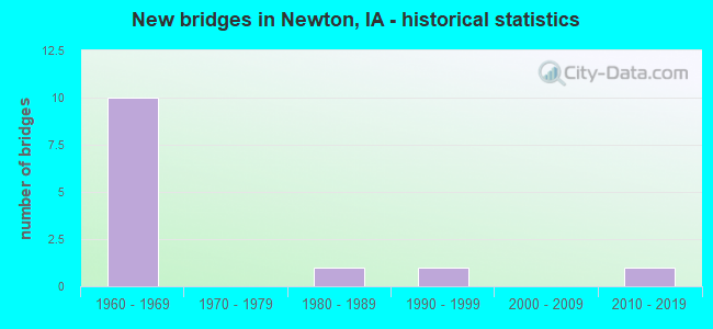
- New bridges - historical statistics
- 31920-1929
- 61930-1939
- 11940-1949
- 11950-1959
- 261960-1969
- 61970-1979
- 81980-1989
- 41990-1999
- 42000-2009
- 52010-2019
- 12020-2022
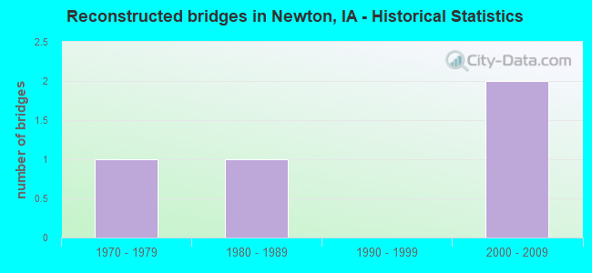
- Reconstructed bridges - Historical Statistics
- 11970-1979
- 11980-1989
- 01990-1999
- 22000-2009
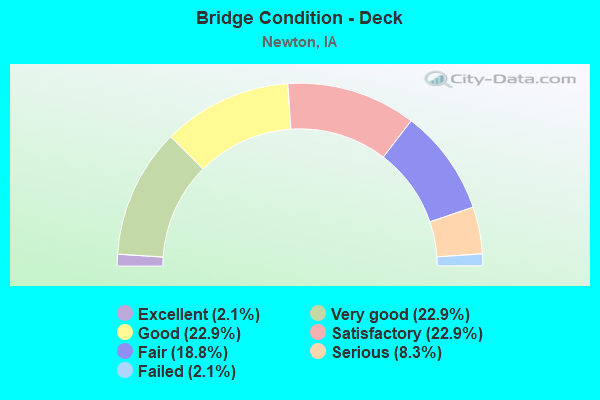
- Bridge Condition - Deck
- 2.1%Excellent
- 22.9%Very good
- 22.9%Good
- 22.9%Satisfactory
- 18.8%Fair
- 8.3%Serious
- 2.1%Failed
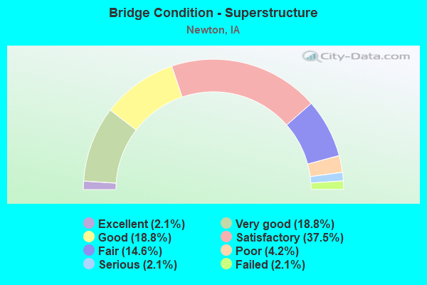
- Bridge Condition - Superstructure
- 2.1%Excellent
- 18.8%Very good
- 18.8%Good
- 37.5%Satisfactory
- 14.6%Fair
- 4.2%Poor
- 2.1%Serious
- 2.1%Failed
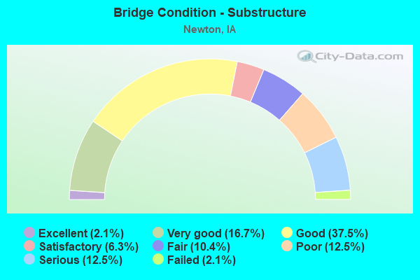
- Bridge Condition - Substructure
- 2.1%Excellent
- 16.7%Very good
- 37.5%Good
- 6.3%Satisfactory
- 10.4%Fair
- 12.5%Poor
- 12.5%Serious
- 2.1%Failed
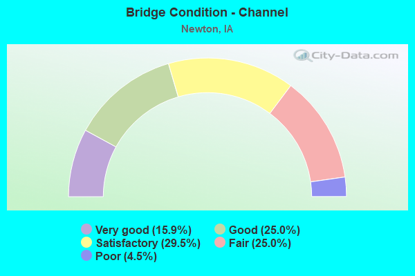
- Bridge Condition - Channel
- 15.9%Very good
- 25.0%Good
- 29.5%Satisfactory
- 25.0%Fair
- 4.5%Poor
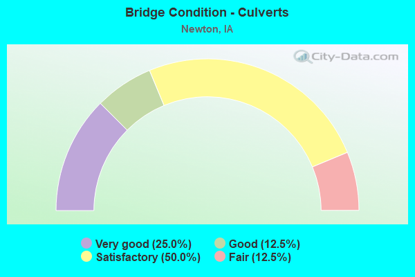
- Bridge Condition - Culverts
- 25.0%Very good
- 12.5%Good
- 50.0%Satisfactory
- 12.5%Fair
Find on map >> Show street view
Structure Number: 197931, Location: 080190104 (Lat: 41.774931, Lng: -93.014550), Route carried "on" structure: County highway , Year Built: 1997, Status: Open, Structure Length: 5.09m (16.70ft), Average Daily Traffic: 25 (year 2014), Average Future Daily Traffic: 25 (year 2040), Design Load: HS 20, Features Intersected: NORTH SKUNK RIVER, Facility Carried by Structure: LOCAL
Minimum Vertical Clearance: 30+ m (98+ ft), Kilometerpoint: 0.800, Lanes on structure: 2, Owner: County Highway Agency, Approaching Roadway Width: 11.6m (38.1ft), Skew: 3 degrees, Material/Design: Prestressed concrete, Design/Construction: Stringer/Multi-beam, Number Of Spans In Main Unit: 3, Length of Maximum Span: 18.6m (61.0ft), Curb-To-Curb Width: 7.5m (24.6ft), Out-to-Out Width: 8.3m (27.2ft)
Condition: Deck: Very good, Superstructure: Very good, Substructure: Very good, Channel: Good, Operating Rating: 69.8 metric tons, Method Used To Determine Operating Rating: Load Factor (LF), Inventory Rating: 38.8 metric tons, Method Used To Determine Inventory Rating: Load Factor (LF), Structural Evaluation: Equal to present desirable criteria, Deck Geometry: Equal to present minimum criteria, Waterway Adequacy: Equal to present desirable criteria, Approach Roadway Alignment: Somewhat better than minimum adequacy, Designated Inspection Frequency: Every 48 months, Inspection Date: April 2020, Deck Structure Type: Concrete Cast-file-Place, Wearing Surface/Protective System: Wearing Surface: Monolithic Concrete
Find on map >> Show street view
Structure Number: 19794, Location: 080190502 (Lat: 41.764181, Lng: -93.096836), Route carried "on" structure: County highway , Year Built: 1937, Status: Posted for load, Structure Length: 1.07m (3.51ft), Average Daily Traffic: 50 (year 2014), Average Future Daily Traffic: 50 (year 2040), Features Intersected: CHERRY CREEK, Facility Carried by Structure: LOCAL
Minimum Vertical Clearance: 30+ m (98+ ft), Kilometerpoint: 2.037, Lanes on structure: 2, Owner: County Highway Agency, Approaching Roadway Width: 7.9m (25.9ft), Material/Design: Steel, Design/Construction: Stringer/Multi-beam, Number Of Spans In Main Unit: 1, Length of Maximum Span: 10.4m (34.1ft), Curb-To-Curb Width: 5.5m (18.0ft), Out-to-Out Width: 5.5m (18.0ft)
Condition: Deck: Fair, Superstructure: Satisfactory, Substructure: Poor, Channel: Fair, Operating Rating: 22.2 metric tons, Method Used To Determine Operating Rating: Load Factor (LF), Inventory Rating: 13.3 metric tons, Method Used To Determine Inventory Rating: Load Factor (LF), Structural Evaluation: Meets minimum limits, Deck Geometry: Meets minimum limits, Waterway Adequacy: Equal to present minimum criteria, Approach Roadway Alignment: Better than present minimum criteria, Bridge Posting: Required (Relationship of Operating Rating to Maximum Legal Load: 20.0 - 29.9% below), Length Of Structure Improvement: 5.00m (16.40ft), Designated Inspection Frequency: Every 24 months, Inspection Date: April 2020, Bridge Improvement Cost: $110,000, Roadway Improvement Cost: $10,000, Deck Structure Type: Wood or Timber, Wearing Surface/Protective System: Wearing Surface: Gravel
Find on map >> Show street view
Structure Number: 197952, Location: 080190701 (Lat: 41.760683, Lng: -93.104558), Route carried "on" structure: County highway , Year Built: 2021, Status: Open, Structure Length: 1.59m (5.22ft), Average Daily Traffic: 50 (year 2014), Average Future Daily Traffic: 50 (year 2041), Features Intersected: CHERRY CREEK, Facility Carried by Structure: N 59TH AVE WEST
Minimum Vertical Clearance: 30+ m (98+ ft), Kilometerpoint: 12.910, Lanes on structure: 2, Owner: County Highway Agency, Approaching Roadway Width: 7.6m (24.9ft), Material/Design: Steel, Design/Construction: Slab, Number Of Spans In Main Unit: 1, Length of Maximum Span: 15.2m (49.9ft), Curb-To-Curb Width: 7.5m (24.6ft), Out-to-Out Width: 7.6m (24.9ft)
Condition: Deck: Excellent, Superstructure: Excellent, Substructure: Excellent, Channel: Very good, Operating Rating: 54.7 metric tons, Method Used To Determine Operating Rating: Load Factor (LF), Inventory Rating: 32.7 metric tons, Method Used To Determine Inventory Rating: Load Factor (LF), Structural Evaluation: Superior to present desirable criteria, Deck Geometry: Equal to present minimum criteria, Waterway Adequacy: Equal to present desirable criteria, Approach Roadway Alignment: Equal to present minimum criteria, Designated Inspection Frequency: Every 24 months, Inspection Date: April 2021, Deck Structure Type: Concrete Cast-file-Place, Wearing Surface/Protective System: Wearing Surface: Monolithic Concrete
Find on map >> Show street view
Structure Number: 19796, Location: 080190703 (Lat: 41.753447, Lng: -93.102611), Route carried "on" structure: County highway , Year Built: 1927, Status: Posted for load-capacity, Structure Length: 0.67m (2.20ft), Average Daily Traffic: 30 (year 2014), Average Future Daily Traffic: 30 (year 2040), Features Intersected: CHERRY CREEK, Facility Carried by Structure: LOCAL
Minimum Vertical Clearance: 30+ m (98+ ft), Kilometerpoint: 1.102, Lanes on structure: 2, Owner: County Highway Agency, Approaching Roadway Width: 7.6m (24.9ft), Material/Design: Concrete, Design/Construction: Slab, Number Of Spans In Main Unit: 1, Length of Maximum Span: 6.1m (20.0ft), Curb-To-Curb Width: 5.5m (18.0ft), Out-to-Out Width: 6.0m (19.7ft)
Condition: Deck: Fair, Superstructure: Fair, Substructure: Fair, Channel: Fair, Operating Rating: 50.2 metric tons, Method Used To Determine Operating Rating: Allowable Stress (AS), Inventory Rating: 30.7 metric tons, Method Used To Determine Inventory Rating: Allowable Stress (AS), Structural Evaluation: Somewhat better than minimum adequacy, Deck Geometry: Meets minimum limits, Waterway Adequacy: Equal to present minimum criteria, Approach Roadway Alignment: Somewhat better than minimum adequacy, Length Of Structure Improvement: 5.50m (18.04ft), Designated Inspection Frequency: Every 24 months, Inspection Date: April 2020, Bridge Improvement Cost: $130,000, Roadway Improvement Cost: $20,000, Deck Structure Type: Concrete Cast-file-Place, Wearing Surface/Protective System: Wearing Surface: Gravel
Find on map >> Show street view
Structure Number: 197981, Location: 080190904 (Lat: 41.748669, Lng: -93.077347), Route carried "on" structure: County highway , Year Built: 1972, Status: Open, Structure Length: 1.07m (3.51ft), Average Daily Traffic: 90 (year 2014), Average Future Daily Traffic: 90 (year 2040), Design Load: HS 20, Features Intersected: SMALL STREAM, Facility Carried by Structure: LOCAL
Minimum Vertical Clearance: 30+ m (98+ ft), Kilometerpoint: 2.087, Lanes on structure: 2, Owner: County Highway Agency, Approaching Roadway Width: 9.4m (30.8ft), Skew: 4 degrees, Material/Design: Concrete continuous, Design/Construction: Culvert, Number Of Spans In Main Unit: 2, Length of Maximum Span: 5.2m (17.1ft)
Condition: Channel: Fair, Culverts: Fair, Operating Rating: 44.1 metric tons, Method Used To Determine Operating Rating: Assigned rating based on Load Factor Design (LFD) reported in metric tons, Inventory Rating: 32.7 metric tons, Method Used To Determine Inventory Rating: Assigned rating based on Load Factor Design (LFD) reported in metric tons, Structural Evaluation: Somewhat better than minimum adequacy, Waterway Adequacy: Equal to present minimum criteria, Approach Roadway Alignment: Better than present minimum criteria, Length Of Structure Improvement: 7.50m (24.61ft), Designated Inspection Frequency: Every 24 months, Inspection Date: April 2020, Bridge Improvement Cost: $160,000, Roadway Improvement Cost: $30,000
Find on map >> Show street view
Structure Number: 19801, Location: 080192005 (Lat: 41.731564, Lng: -93.081797), Route carried "on" structure: County highway , Year Built: 1930, Status: Posted for load, Structure Length: 1.31m (4.30ft), Average Daily Traffic: 40 (year 2014), Average Future Daily Traffic: 40 (year 2040), Design Load: H 10, Features Intersected: SMALL STREAM, Facility Carried by Structure: LOCAL
Minimum Vertical Clearance: 30+ m (98+ ft), Kilometerpoint: 4.488, Lanes on structure: 2, Owner: County Highway Agency, Approaching Roadway Width: 7.6m (24.9ft), Material/Design: Steel, Design/Construction: Stringer/Multi-beam, Number Of Spans In Main Unit: 1, Length of Maximum Span: 12.5m (41.0ft), Curb-To-Curb Width: 6.2m (20.3ft), Out-to-Out Width: 6.2m (20.3ft)
Condition: Deck: Fair, Superstructure: Fair, Substructure: Fair, Channel: Satisfactory, Operating Rating: 31.5 metric tons, Method Used To Determine Operating Rating: Allowable Stress (AS), Inventory Rating: 21.0 metric tons, Method Used To Determine Inventory Rating: Allowable Stress (AS), Structural Evaluation: Somewhat better than minimum adequacy, Deck Geometry: Somewhat better than minimum adequacy, Waterway Adequacy: Equal to present minimum criteria, Approach Roadway Alignment: Equal to present minimum criteria, Bridge Posting: Required (Relationship of Operating Rating to Maximum Legal Load: 10.0 - 19.9% below), Length Of Structure Improvement: 5.00m (16.40ft), Designated Inspection Frequency: Every 24 months, Inspection Date: April 2020, Bridge Improvement Cost: $180,000, Roadway Improvement Cost: $30,000, Deck Structure Type: Wood or Timber, Wearing Surface/Protective System: Wearing Surface: Gravel
Find on map >> Show street view
Structure Number: 19802, Location: 080192008 (Lat: 41.724664, Lng: -93.086828), Route carried "on" structure: County highway , Year Built: 1931, Year Reconstructed: 1989, Status: Closed, Structure Length: 1.28m (4.20ft), Average Daily Traffic: 90 (year 2014), Average Future Daily Traffic: 90 (year 2040), Features Intersected: CHERRY CREEK, Facility Carried by Structure: LOCAL
Minimum Vertical Clearance: 30+ m (98+ ft), Kilometerpoint: 2.569, Lanes on structure: 2, Owner: County Highway Agency, Approaching Roadway Width: 7.6m (24.9ft), Material/Design: Steel, Design/Construction: Stringer/Multi-beam, Number Of Spans In Main Unit: 1, Length of Maximum Span: 12.2m (40.0ft), Curb-To-Curb Width: 6.2m (20.3ft), Out-to-Out Width: 6.2m (20.3ft)
Condition: Deck: Failed, Superstructure: Failed, Substructure: Failed, Channel: Fair, Deck Geometry: Somewhat better than minimum adequacy, Waterway Adequacy: Somewhat better than minimum adequacy, Approach Roadway Alignment: Better than present minimum criteria, Bridge Posting: Required (Relationship of Operating Rating to Maximum Legal Load: > 39.9% below), Length Of Structure Improvement: 5.70m (18.70ft), Designated Inspection Frequency: Every 24 months, Inspection Date: April 2020, Bridge Improvement Cost: $190,000, Roadway Improvement Cost: $30,000, Deck Structure Type: Wood or Timber, Wearing Surface/Protective System: Wearing Surface: Gravel
Find on map >> Show street view
Structure Number: 19803, Location: 080192009 (Lat: 41.721806, Lng: -93.085272), Route carried "on" structure: County highway , Year Built: 1970, Status: Open, Structure Length: 4.66m (15.29ft), Average Daily Traffic: 990 (year 2018), Average Future Daily Traffic: 990 (year 2040), Design Load: H 20, Features Intersected: CHERRY CREEK, Facility Carried by Structure: FM
Minimum Vertical Clearance: 30+ m (98+ ft), Kilometerpoint: 4.620, Lanes on structure: 2, Owner: County Highway Agency, Approaching Roadway Width: 11.6m (38.1ft), Material/Design: Steel continuous, Design/Construction: Stringer/Multi-beam, Number Of Spans In Main Unit: 3, Length of Maximum Span: 17.7m (58.1ft), Curb-To-Curb Width: 8.6m (28.2ft), Out-to-Out Width: 9.1m (29.9ft)
Condition: Deck: Serious, Superstructure: Satisfactory, Substructure: Fair, Channel: Fair, Operating Rating: 39.0 metric tons, Method Used To Determine Operating Rating: Allowable Stress (AS), Inventory Rating: 26.3 metric tons, Method Used To Determine Inventory Rating: Allowable Stress (AS), Structural Evaluation: Somewhat better than minimum adequacy, Deck Geometry: Somewhat better than minimum adequacy, Waterway Adequacy: Better than present minimum criteria, Approach Roadway Alignment: Better than present minimum criteria, Length Of Structure Improvement: 17.00m (55.77ft), Designated Inspection Frequency: Every 24 months, Inspection Date: April 2020, Bridge Improvement Cost: $460,000, Roadway Improvement Cost: $60,000, Deck Structure Type: Concrete Cast-file-Place, Wearing Surface/Protective System: Wearing Surface: Monolithic Concrete
Find on map >> Show street view
Structure Number: 198041, Location: 080192101 (Lat: 41.725733, Lng: -93.067517), Route carried "on" structure: County highway , Year Built: 1997, Status: Open, Structure Length: 1.34m (4.40ft), Average Daily Traffic: 40 (year 2014), Average Future Daily Traffic: 40 (year 2040), Design Load: H 10, Features Intersected: BENJAMIN CREEK, Facility Carried by Structure: LOCAL
Minimum Vertical Clearance: 30+ m (98+ ft), Kilometerpoint: 0.557, Lanes on structure: 2, Owner: County Highway Agency, Approaching Roadway Width: 7.3m (24.0ft), Material/Design: Steel, Design/Construction: Stringer/Multi-beam, Number Of Spans In Main Unit: 1, Length of Maximum Span: 12.8m (42.0ft), Curb-To-Curb Width: 7.3m (24.0ft), Out-to-Out Width: 7.4m (24.3ft)
Condition: Deck: Good, Superstructure: Satisfactory, Substructure: Satisfactory, Channel: Satisfactory, Operating Rating: 33.1 metric tons, Method Used To Determine Operating Rating: Allowable Stress (AS), Inventory Rating: 19.8 metric tons, Method Used To Determine Inventory Rating: Allowable Stress (AS), Structural Evaluation: Somewhat better than minimum adequacy, Deck Geometry: Equal to present minimum criteria, Waterway Adequacy: Somewhat better than minimum adequacy, Approach Roadway Alignment: Equal to present desirable criteria, Designated Inspection Frequency: Every 24 months, Inspection Date: April 2020, Deck Structure Type: Corrugated Steel, Wearing Surface/Protective System: Wearing Surface: Gravel
Find on map >> Show street view
Structure Number: 198071, Location: 080193609 (Lat: 41.692744, Lng: -93.001906), Route carried "on" structure: County highway , Year Built: 2000, Status: Open, Structure Length: 1.28m (4.20ft), Average Daily Traffic: 150 (year 2014), Average Future Daily Traffic: 150 (year 2040), Features Intersected: ELK CREEK, Facility Carried by Structure: LOCAL
Minimum Vertical Clearance: 30+ m (98+ ft), Kilometerpoint: 0.650, Lanes on structure: 2, Owner: County Highway Agency, Approaching Roadway Width: 7.9m (25.9ft), Material/Design: Steel, Design/Construction: Stringer/Multi-beam, Number Of Spans In Main Unit: 1, Length of Maximum Span: 12.5m (41.0ft), Curb-To-Curb Width: 7.9m (25.9ft), Out-to-Out Width: 7.9m (25.9ft)
Condition: Deck: Very good, Superstructure: Satisfactory, Substructure: Very good, Channel: Satisfactory, Operating Rating: 45.8 metric tons, Method Used To Determine Operating Rating: Allowable Stress (AS), Inventory Rating: 29.2 metric tons, Method Used To Determine Inventory Rating: Allowable Stress (AS), Structural Evaluation: Equal to present minimum criteria, Deck Geometry: Somewhat better than minimum adequacy, Waterway Adequacy: Equal to present minimum criteria, Approach Roadway Alignment: Equal to present minimum criteria, Designated Inspection Frequency: Every 24 months, Inspection Date: March 2020, Deck Structure Type: Concrete Cast-file-Place, Wearing Surface/Protective System: Wearing Surface: Monolithic Concrete
Find on map >> Show street view
Structure Number: 199241, Location: 081193504 (Lat: 41.790150, Lng: -93.029528), Route carried "on" structure: County highway , Year Built: 1984, Status: Open, Structure Length: 4.72m (15.49ft), Average Daily Traffic: 35 (year 2014), Average Future Daily Traffic: 35 (year 2040), Design Load: HS 20, Features Intersected: N SKUNK RIVER, Facility Carried by Structure: LOCAL
Minimum Vertical Clearance: 30+ m (98+ ft), Kilometerpoint: 2.987, Lanes on structure: 2, Owner: County Highway Agency, Approaching Roadway Width: 8.5m (27.9ft), Material/Design: Prestressed concrete, Design/Construction: Stringer/Multi-beam, Number Of Spans In Main Unit: 3, Length of Maximum Span: 17.4m (57.1ft), Curb-To-Curb Width: 7.3m (24.0ft), Out-to-Out Width: 7.9m (25.9ft)
Condition: Deck: Good, Superstructure: Good, Substructure: Good, Channel: Good, Operating Rating: 67.5 metric tons, Method Used To Determine Operating Rating: Load Factor (LF), Inventory Rating: 39.4 metric tons, Method Used To Determine Inventory Rating: Load Factor (LF), Structural Evaluation: Better than present minimum criteria, Deck Geometry: Equal to present minimum criteria, Waterway Adequacy: Equal to present minimum criteria, Approach Roadway Alignment: Equal to present minimum criteria, Designated Inspection Frequency: Every 48 months, Inspection Date: April 2020, Deck Structure Type: Concrete Cast-file-Place, Wearing Surface/Protective System: Wearing Surface: Monolithic Concrete
Find on map >> Show street view
Structure Number: 362406, Location: 000000000 (Lat: 41.677767, Lng: -93.005572), Route carried "on" structure: City street , Year Built: 1998, Status: Open, Structure Length: 0.82m (2.69ft), Average Daily Traffic: 490 (year 2014), Average Future Daily Traffic: 490 (year 2041), Design Load: HS 20, Features Intersected: SMALL STREAM, Facility Carried by Structure: RUSTY WALACE DR
Minimum Vertical Clearance: 30+ m (98+ ft), Kilometerpoint: 2.849, Lanes on structure: 2, Owner: City or Municipal Highway Agency, Approaching Roadway Width: 10.4m (34.1ft), Skew: 3 degrees, Material/Design: Concrete continuous, Design/Construction: Culvert, Number Of Spans In Main Unit: 2, Length of Maximum Span: 3.7m (12.1ft)
Condition: Channel: Good, Culverts: Satisfactory, Operating Rating: 58.3 metric tons, Method Used To Determine Operating Rating: Load Factor (LF) rating reported by rating factor (RF) method using MS18 loading, Inventory Rating: 35.0 metric tons, Method Used To Determine Inventory Rating: Load Factor (LF) rating reported by rating factor (RF) method using MS18 loading, Structural Evaluation: Equal to present minimum criteria, Waterway Adequacy: Equal to present desirable criteria, Approach Roadway Alignment: Equal to present desirable criteria, Length Of Structure Improvement: 9.60m (31.50ft), Designated Inspection Frequency: Every 24 months, Inspection Date: August 2021, Bridge Improvement Cost: $1,000, Roadway Improvement Cost: $1,000
Find on map >> Show street view
Structure Number: 36325, Location: 079190803 (Lat: 41.670650, Lng: -93.087767), Route carried "on" structure: County highway , Year Built: 1990, Status: Posted for load, Structure Length: 1.28m (4.20ft), Average Daily Traffic: 80 (year 2014), Average Future Daily Traffic: 80 (year 2041), Features Intersected: SMALL STREAM, Facility Carried by Structure: S 32ND AVE W
Minimum Vertical Clearance: 30+ m (98+ ft), Kilometerpoint: 0.758, Lanes on structure: 2, Owner: County Highway Agency, Approaching Roadway Width: 6.1m (20.0ft), Skew: 4 degrees, Material/Design: Steel, Design/Construction: Stringer/Multi-beam, Number Of Spans In Main Unit: 1, Length of Maximum Span: 12.5m (41.0ft), Curb-To-Curb Width: 6.1m (20.0ft), Out-to-Out Width: 6.2m (20.3ft)
Condition: Deck: Satisfactory, Superstructure: Satisfactory, Substructure: Satisfactory, Channel: Fair, Operating Rating: 32.1 metric tons, Method Used To Determine Operating Rating: Load Factor (LF), Inventory Rating: 19.2 metric tons, Method Used To Determine Inventory Rating: Load Factor (LF), Structural Evaluation: Somewhat better than minimum adequacy, Deck Geometry: Somewhat better than minimum adequacy, Waterway Adequacy: Somewhat better than minimum adequacy, Approach Roadway Alignment: Better than present minimum criteria, Bridge Posting: Required (Relationship of Operating Rating to Maximum Legal Load: 10.0 - 19.9% below), Length Of Structure Improvement: 5.00m (16.40ft), Designated Inspection Frequency: Every 24 months, Inspection Date: April 2021, Bridge Improvement Cost: $105,000, Roadway Improvement Cost: $15,000, Deck Structure Type: Wood or Timber, Wearing Surface/Protective System: Wearing Surface: Gravel
Find on map >> Show street view
Structure Number: 503911, Location: 000000000 (Lat: 41.688322, Lng: -93.082694), Route carried "on" structure: City street , Year Built: 2016, Status: Open, Structure Length: 0.75m (2.46ft), Average Daily Traffic: 310 (year 2014), Average Future Daily Traffic: 310 (year 2041), Design Load: HL 93, Features Intersected: SMALL STREAM, Facility Carried by Structure: S 12TH AVE WEST
Minimum Vertical Clearance: 30+ m (98+ ft), Kilometerpoint: 0.211, Lanes on structure: 2, Owner: City or Municipal Highway Agency, Approaching Roadway Width: 9.1m (29.9ft), Material/Design: Concrete continuous, Design/Construction: Culvert, Number Of Spans In Main Unit: 2, Length of Maximum Span: 3.7m (12.1ft)
Condition: Channel: Very good, Culverts: Very good, Operating Rating: 51.8 metric tons, Method Used To Determine Operating Rating: Load and Resistance Factor Rating (LRFR) rating reported by rating factor(RF) method using HL-93 loadings, Inventory Rating: 40.2 metric tons, Method Used To Determine Inventory Rating: Load and Resistance Factor Rating (LRFR) rating reported by rating factor(RF) method using HL-93 loadings, Structural Evaluation: Equal to present desirable criteria, Waterway Adequacy: Equal to present desirable criteria, Approach Roadway Alignment: Equal to present desirable criteria, Designated Inspection Frequency: Every 24 months, Inspection Date: August 2021
Find on map >> Show street view
Structure Number: 505455, Location: 000000000 (Lat: 41.675133, Lng: -93.003897), Route carried "on" structure: City street , Year Built: 2005, Status: Open, Structure Length: 0.70m (2.30ft), Average Daily Traffic: 310 (year 2014), Average Future Daily Traffic: 310 (year 2041), Design Load: HS 20, Features Intersected: CARSON CREEK, Facility Carried by Structure: IOWA SPEEDWAY DR
Minimum Vertical Clearance: 30+ m (98+ ft), Kilometerpoint: 0.457, Lanes on structure: 4, Owner: City or Municipal Highway Agency, Approaching Roadway Width: 9.1m (29.9ft), Material/Design: Concrete continuous, Design/Construction: Culvert, Number Of Spans In Main Unit: 2, Length of Maximum Span: 3.7m (12.1ft)
Condition: Channel: Good, Culverts: Very good, Operating Rating: 93.0 metric tons, Method Used To Determine Operating Rating: Load Factor (LF) rating reported by rating factor (RF) method using MS18 loading, Inventory Rating: 55.7 metric tons, Method Used To Determine Inventory Rating: Load Factor (LF) rating reported by rating factor (RF) method using MS18 loading, Structural Evaluation: Equal to present desirable criteria, Waterway Adequacy: Better than present minimum criteria, Approach Roadway Alignment: Equal to present minimum criteria, Designated Inspection Frequency: Every 24 months, Inspection Date: August 2021
Find on map >> Show street view
Structure Number: 3061, Location: AT JCT. I-80 (Lat: 41.683083, Lng: -93.076994), Route carried "under" structure: Interstate 80, Year Built: 1962, Structure Length: 0. m, Average Daily Traffic: 11,650 (year 2020), Truck Traffic: 32%, Features Intersected: I-80, Facility Carried by Structure: EB US 6 & NB 14
Minimum Vertical Clearance: 30+ m (98+ ft), Kilometerpoint: 263.940, Lanes on structure: 2, Lanes under structure: 5, Material/Design: Steel continuous, Design/Construction: Stringer/Multi-beam, Length of Maximum Span: 24.1m (79.1ft)
Find on map >> Show street view
Structure Number: 3062, Location: AT JCT. I-80 (Lat: 41.683736, Lng: -93.077300), Route carried "under" structure: Interstate 80, Year Built: 1962, Structure Length: 0. m, Average Daily Traffic: 23,300 (year 2020), Truck Traffic: 32%, Features Intersected: I-80, Facility Carried by Structure: WB US 6 & SB 14
Minimum Vertical Clearance: 30+ m (98+ ft), Kilometerpoint: 263.918, Lanes on structure: 2, Lanes under structure: 5, Material/Design: Steel continuous, Design/Construction: Stringer/Multi-beam, Length of Maximum Span: 24.1m (79.1ft)
Find on map >> Show street view
Structure Number: 3103, Location: 3.3 MILES W OF JCT IA 14 (Lat: 41.682806, Lng: -93.140394), Route carried "under" structure: Interstate 80, Year Built: 1961, Structure Length: 0. m, Average Daily Traffic: 29,100 (year 2020), Truck Traffic: 27%, Features Intersected: I-80, Facility Carried by Structure: W 62ND ST S
Minimum Vertical Clearance: 30+ m (98+ ft), Kilometerpoint: 258.628, Lanes on structure: 2, Lanes under structure: 4, Material/Design: Prestressed concrete, Design/Construction: Stringer/Multi-beam, Length of Maximum Span: 19.8m (65.0ft)
Find on map >> Show street view
Structure Number: 3104, Location: 2.0 MILES WEST OF IOWA 14 (Lat: 41.681067, Lng: -93.116297), Route carried "under" structure: Interstate 80, Year Built: 1961, Structure Length: 0. m, Average Daily Traffic: 29,100 (year 2020), Truck Traffic: 27%, Features Intersected: I-80, Facility Carried by Structure: CO RD S 60
Minimum Vertical Clearance: 30+ m (98+ ft), Kilometerpoint: 260.645, Lanes on structure: 2, Lanes under structure: 4, Material/Design: Prestressed concrete, Design/Construction: Stringer/Multi-beam, Length of Maximum Span: 19.8m (65.0ft)
Find on map >> Show street view
Structure Number: 3111, Location: 1.0 MILE E OF JCT IA 14 (Lat: 41.683511, Lng: -93.058336), Route carried "under" structure: Interstate 80, Year Built: 1962, Structure Length: 0. m, Average Daily Traffic: 25,700 (year 2020), Truck Traffic: 31%, Features Intersected: I-80, Facility Carried by Structure: W 4TH ST
Minimum Vertical Clearance: 30+ m (98+ ft), Kilometerpoint: 265.495, Lanes on structure: 2, Lanes under structure: 4, Material/Design: Prestressed concrete, Design/Construction: Stringer/Multi-beam, Length of Maximum Span: 19.8m (65.0ft)
Find on map >> Show street view
Structure Number: 3112, Location: 1.5 MILES E OF JCT IA 14 (Lat: 41.683403, Lng: -93.048433), Route carried "under" structure: Interstate 80, Year Built: 1962, Structure Length: 0. m, Average Daily Traffic: 25,700 (year 2020), Truck Traffic: 31%, Features Intersected: I-80, Facility Carried by Structure: E 5TH ST
Minimum Vertical Clearance: 30+ m (98+ ft), Kilometerpoint: 266.317, Lanes on structure: 2, Lanes under structure: 4, Material/Design: Prestressed concrete, Design/Construction: Stringer/Multi-beam, Length of Maximum Span: 19.5m (64.0ft)
Find on map >> Show street view
Structure Number: 3113, Location: 2.0 MILES E OF JCT IA 14 (Lat: 41.682958, Lng: -93.039008), Route carried "under" structure: Interstate 80, Year Built: 1962, Structure Length: 0. m, Average Daily Traffic: 25,700 (year 2020), Truck Traffic: 31%, Features Intersected: I-80, Facility Carried by Structure: E 12TH ST
Minimum Vertical Clearance: 30+ m (98+ ft), Kilometerpoint: 267.108, Lanes on structure: 2, Lanes under structure: 4, Material/Design: Prestressed concrete, Design/Construction: Stringer/Multi-beam, Length of Maximum Span: 19.5m (64.0ft)
Find on map >> Show street view
Structure Number: 3114, Location: 4.0 MI. E OF JCT. IA 14 (Lat: 41.682486, Lng: -93.000153), Route carried "under" structure: County highway , Year Built: 1962, Structure Length: 0. m, Average Daily Traffic: 2,550 (year 2018), Truck Traffic: 20%, Features Intersected: IOWA SPEEDWAY DR, Facility Carried by Structure: I 80 EB
Minimum Vertical Clearance: 30+ m (98+ ft), Kilometerpoint: 0.158, Lanes on structure: 2, Lanes under structure: 3, Material/Design: Prestressed concrete, Design/Construction: Stringer/Multi-beam, Length of Maximum Span: 14.3m (46.9ft)
Find on map >> Show street view
Structure Number: 3115, Location: 4.0 mi. E of Jct. IA #14 (Lat: 41.682667, Lng: -92.999625), Route carried "under" structure: County highway , Year Built: 1962, Structure Length: 0. m, Average Daily Traffic: 2,550 (year 2018), Truck Traffic: 20%, Features Intersected: IOWA SPEEDWAY DR, Facility Carried by Structure: I 80 WB
Minimum Vertical Clearance: 30+ m (98+ ft), Kilometerpoint: 0.182, Lanes on structure: 2, Lanes under structure: 3, Material/Design: Prestressed concrete, Design/Construction: Stringer/Multi-beam, Length of Maximum Span: 14.3m (46.9ft)