Bridge Statistics for Norristown, Pennsylvania (PA)
Condition, Traffic, Stress, Structural Evaluation, Project Costs
- National Bridge Inventory (NBI) Statistics
- 50Number of bridges
- 876ft / 267mTotal length
- $28,763,000Total costs
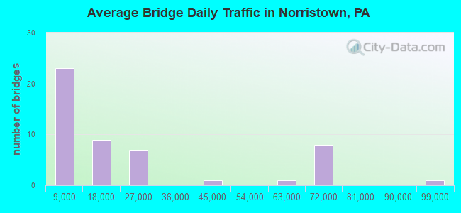
- 1,087,437Total average daily traffic
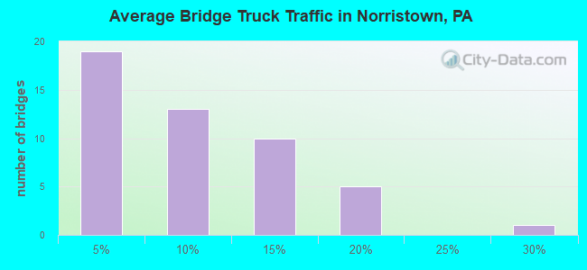
- 112,846Total average daily truck traffic
- National Bridge Inventory (NBI) Registered Bridges for Norristown
- No street view available for this location
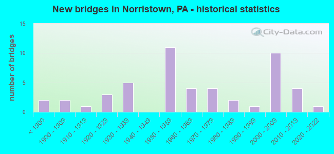
- New bridges - historical statistics
- 2Before 1900
- 21900-1909
- 11910-1919
- 31920-1929
- 51930-1939
- 111950-1959
- 41960-1969
- 41970-1979
- 21980-1989
- 11990-1999
- 102000-2009
- 42010-2019
- 12020-2022
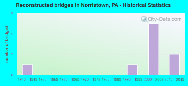
- Reconstructed bridges - Historical Statistics
- 11940-1949
- 01950-1959
- 01960-1969
- 01970-1979
- 01980-1989
- 11990-1999
- 52000-2009
- 22010-2019
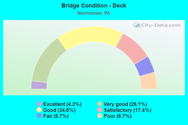
- Bridge Condition - Deck
- 4.3%Excellent
- 26.1%Very good
- 34.8%Good
- 17.4%Satisfactory
- 8.7%Fair
- 8.7%Poor
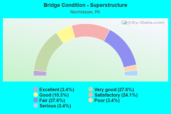
- Bridge Condition - Superstructure
- 3.4%Excellent
- 27.6%Very good
- 10.3%Good
- 24.1%Satisfactory
- 27.6%Fair
- 3.4%Poor
- 3.4%Serious
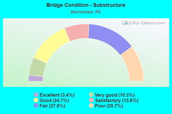
- Bridge Condition - Substructure
- 3.4%Excellent
- 10.3%Very good
- 24.1%Good
- 13.8%Satisfactory
- 27.6%Fair
- 20.7%Poor
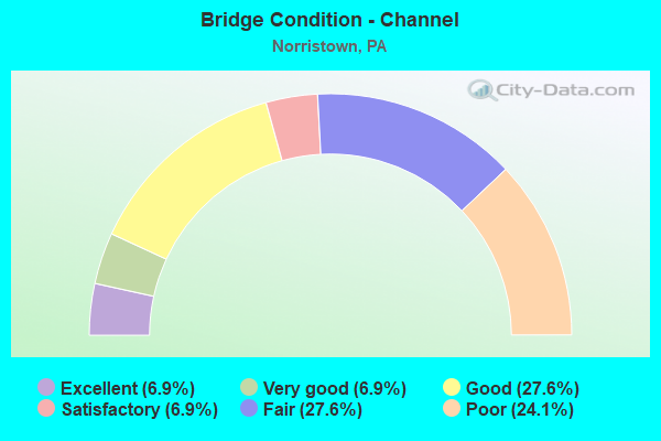
- Bridge Condition - Channel
- 6.9%Excellent
- 6.9%Very good
- 27.6%Good
- 6.9%Satisfactory
- 27.6%Fair
- 24.1%Poor
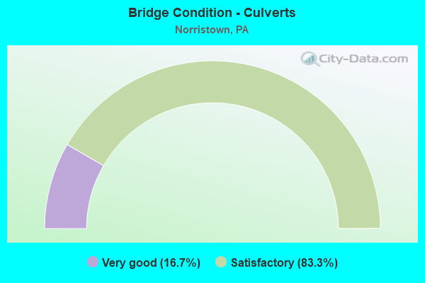
- Bridge Condition - Culverts
- 16.7%Very good
- 83.3%Satisfactory
Find on map >> Show street view
Structure Number: 28155, Location: EAST OF BRIDGEPORT (Lat: 40.102850, Lng: -75.325903), Route carried "under" structure: State highway , Year Built: 1954, Structure Length: 0. m, Average Daily Traffic: 707 (year 2022), Truck Traffic: 7%, Features Intersected: SR0023,SR3025,NSRR,SEPTA, Facility Carried by Structure: PA TPK (I-276)
Minimum Vertical Clearance: 7.72m (25.33ft), Kilometerpoint: 0.000, Lanes on structure: 2, Lanes under structure: 4, Material/Design: Steel continuous, Design/Construction: Girder and Floorbeam System, Length of Maximum Span: 39.6m (129.9ft)
Find on map >> Show street view
Structure Number: 28155, Location: EAST OF BRIDGEPORT (Lat: 40.102850, Lng: -75.325903), Route carried "under" structure: State highway 23, Year Built: 1954, Structure Length: 0. m, Average Daily Traffic: 4,296 (year 2020), Truck Traffic: 15%, Features Intersected: SR0023,SR3025,NSRR,SEPTA, Facility Carried by Structure: PA TPK (I-276)
Minimum Vertical Clearance: 13.54m (44.42ft), Kilometerpoint: 12.411, Lanes on structure: 2, Lanes under structure: 4, Material/Design: Steel continuous, Design/Construction: Girder and Floorbeam System, Length of Maximum Span: 39.6m (129.9ft)
Find on map >> Show street view
Structure Number: 28157, Location: SOUTHEAST OF NORRISTOWN (Lat: 40.105719, Lng: -75.314500), Route carried "under" structure: Interstate 276, Year Built: 1954, Structure Length: 0. m, Average Daily Traffic: 65,138 (year 2004), Truck Traffic: 12%, Features Intersected: PA TPK (I-276), Facility Carried by Structure: RIDGE PIKE
Minimum Vertical Clearance: 4.78m (15.68ft), Kilometerpoint: 0.000, Lanes on structure: 4, Lanes under structure: 4, Toll: On toll road, Material/Design: Steel continuous, Design/Construction: Stringer/Multi-beam, Length of Maximum Span: 34.7m (113.8ft)
Find on map >> Show street view
Structure Number: 28159, Location: WEST OF NORRISTOWN INTG (Lat: 40.107769, Lng: -75.303167), Route carried "under" structure: City street , Year Built: 2006, Structure Length: 0. m, Average Daily Traffic: 200 (year 1992), Features Intersected: T-694, Facility Carried by Structure: PA TPK (I-276)
Minimum Vertical Clearance: 4.51m (14.80ft), Kilometerpoint: 0.000, Lanes on structure: 4, Lanes under structure: 2, Toll: On toll road, Material/Design: Prestressed concrete, Design/Construction: Box Beam or Girders - Single/Spread, Length of Maximum Span: 10.7m (35.1ft)
Find on map >> Show street view
Structure Number: 28161, Location: NORRISTOWN INTERCHANGE (Lat: 40.101667, Lng: -75.284444), Route carried "under" structure: State highway 73, Year Built: 1954, Structure Length: 0. m, Average Daily Traffic: 18,393 (year 2018), Truck Traffic: 2%, Features Intersected: PA TPK (I-276), Facility Carried by Structure: PA TPK RAMP AB
Minimum Vertical Clearance: 4.72m (15.49ft), Kilometerpoint: 39.912, Lanes on structure: 2, Lanes under structure: 2, Material/Design: Steel continuous, Design/Construction: Stringer/Multi-beam, Length of Maximum Span: 37.8m (124.0ft)
Find on map >> Show street view
Structure Number: 28161, Location: NORRISTOWN INTERCHANGE (Lat: 40.101667, Lng: -75.284444), Route carried "under" structure: Interstate 276, Year Built: 1954, Structure Length: 0. m, Average Daily Traffic: 90,561 (year 2004), Truck Traffic: 10%, Features Intersected: PA TPK (I-276), Facility Carried by Structure: PA TPK RAMP AB
Minimum Vertical Clearance: 4.72m (15.49ft), Kilometerpoint: 0.000, Lanes on structure: 2, Lanes under structure: 5, Toll: On toll road, Material/Design: Steel continuous, Design/Construction: Stringer/Multi-beam, Length of Maximum Span: 37.8m (124.0ft)
Find on map >> Show street view
Structure Number: 41242, Location: EAST OF BRIDGEPORT (Lat: 40.102911, Lng: -75.325731), Route carried "under" structure: City street , Year Built: 2000, Structure Length: 0. m, Average Daily Traffic: 8,643 (year 2000), Truck Traffic: 5%, Features Intersected: SR0023,SR3025,NSRR,SEPTA, Facility Carried by Structure: PA TPK (I-276 EB)
Minimum Vertical Clearance: 8.63m (28.31ft), Kilometerpoint: 0.000, Lanes on structure: 2, Lanes under structure: 4, Material/Design: Steel continuous, Design/Construction: Stringer/Multi-beam, Length of Maximum Span: 75.6m (248.0ft)
Find on map >> Show street view
Structure Number: 41242, Location: EAST OF BRIDGEPORT (Lat: 40.102911, Lng: -75.325731), Route carried "under" structure: State highway 23, Year Built: 2000, Structure Length: 0. m, Average Daily Traffic: 11,928 (year 2001), Truck Traffic: 5%, Features Intersected: SR0023,SR3025,NSRR,SEPTA, Facility Carried by Structure: PA TPK (I-276 EB)
Minimum Vertical Clearance: 13.54m (44.42ft), Kilometerpoint: 0.000, Lanes on structure: 2, Lanes under structure: 4, Material/Design: Steel continuous, Design/Construction: Stringer/Multi-beam, Length of Maximum Span: 75.6m (248.0ft)
Find on map >> Show street view
Structure Number: 45261, Location: N. OF RIDGE PIKE 3368A3 (Lat: 40.106136, Lng: -75.312081), Route carried "under" structure: Interstate 267, Year Built: 2008, Structure Length: 0. m, Average Daily Traffic: 65,138 (year 2004), Truck Traffic: 12%, Features Intersected: PA TURNPIKE (I-276), Facility Carried by Structure: BELVOIR ROAD
Minimum Vertical Clearance: 7.47m (24.51ft), Kilometerpoint: 0.000, Lanes on structure: 2, Lanes under structure: 6, Material/Design: Steel, Design/Construction: Stringer/Multi-beam, Length of Maximum Span: 48.8m (160.1ft)
Find on map >> Show street view
Structure Number: 4885, Location: Norristown (Lat: 40.137389, Lng: -75.287889), Route carried "under" structure: State highway , Year Built: 2014, Structure Length: 0. m, Average Daily Traffic: 12,597 (year 2022), Truck Traffic: 3%, Features Intersected: LR 46154; SR 3001, Facility Carried by Structure: PA TPK (I-476)
Minimum Vertical Clearance: 5.09m (16.70ft), Kilometerpoint: 3.523, Lanes on structure: 4, Lanes under structure: 2, Material/Design: Steel, Design/Construction: Stringer/Multi-beam, Length of Maximum Span: 35.1m (115.2ft)