Bridge Statistics for North Charleston, South Carolina (SC)
Condition, Traffic, Stress, Structural Evaluation, Project Costs
- National Bridge Inventory (NBI) Statistics
- 155Number of bridges
- 6,736ft / 2,053mTotal length
- $236,455,000Total costs
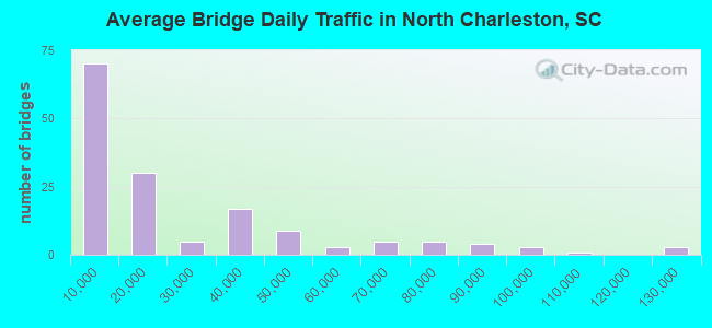
- 3,730,024Total average daily traffic
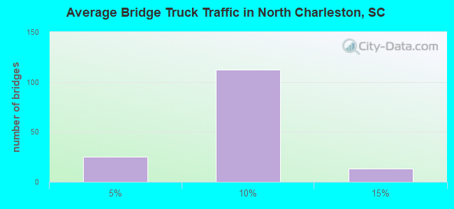
- 300,824Total average daily truck traffic
- National Bridge Inventory (NBI) Registered Bridges for North Charleston
- No street view available for this location
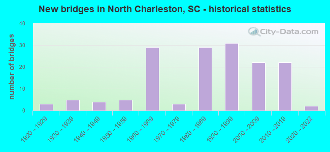
- New bridges - historical statistics
- 31920-1929
- 51930-1939
- 41940-1949
- 51950-1959
- 291960-1969
- 31970-1979
- 291980-1989
- 311990-1999
- 222000-2009
- 222010-2019
- 22020-2022
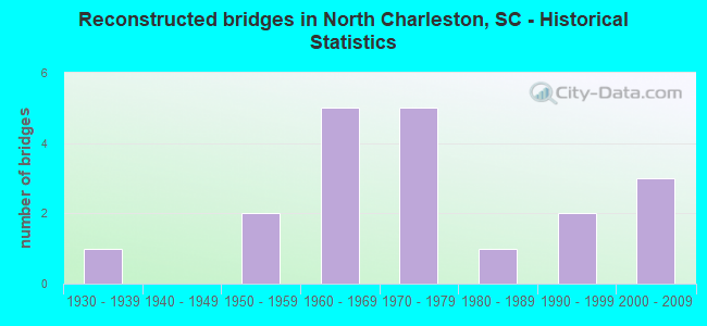
- Reconstructed bridges - Historical Statistics
- 11930-1939
- 01940-1949
- 21950-1959
- 51960-1969
- 51970-1979
- 11980-1989
- 21990-1999
- 32000-2009
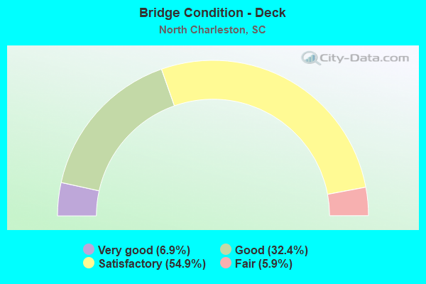
- Bridge Condition - Deck
- 6.9%Very good
- 32.4%Good
- 54.9%Satisfactory
- 5.9%Fair
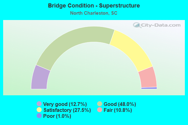
- Bridge Condition - Superstructure
- 12.7%Very good
- 48.0%Good
- 27.5%Satisfactory
- 10.8%Fair
- 1.0%Poor
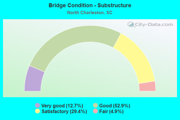
- Bridge Condition - Substructure
- 12.7%Very good
- 52.9%Good
- 29.4%Satisfactory
- 4.9%Fair
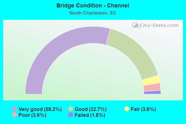
- Bridge Condition - Channel
- 58.2%Very good
- 32.7%Good
- 3.6%Fair
- 3.6%Poor
- 1.8%Failed
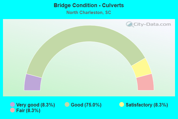
- Bridge Condition - Culverts
- 8.3%Very good
- 75.0%Good
- 8.3%Satisfactory
- 8.3%Fair
Find on map >> Show street view
Structure Number: 128, Location: 10.2MI SW MONCKS CORNER (Lat: 33.050522, Lng: -80.033731), Route carried "on" structure: US 52, Year Built: 1922, Year Reconstructed: 1941, Status: Open, Structure Length: 1.34m (4.40ft), Average Daily Traffic: 16,450 (year 2020), Truck Traffic: 7%, Average Future Daily Traffic: 23,524 (year 2040), Design Load: H 15, Features Intersected: LAUREL CREEK SWAMP
Minimum Vertical Clearance: 30+ m (98+ ft), Kilometerpoint: 7.387, Lanes on structure: 2, Base Highway Network: Yes, Owner: State Highway Agency, Approaching Roadway Width: 7.4m (24.3ft), Material/Design: Concrete, Design/Construction: Tee Beam, Number Of Spans In Main Unit: 2, Length of Maximum Span: 6.7m (22.0ft), Curb or Sidewalk Widths: Left: 0.2m (0.7ft), Right: 0.2m (0.7ft), Curb-To-Curb Width: 11.2m (36.7ft), Out-to-Out Width: 12.7m (41.7ft)
Condition: Deck: Satisfactory, Superstructure: Satisfactory, Substructure: Satisfactory, Channel: Good, Operating Rating: 16.8 metric tons, Method Used To Determine Operating Rating: Load and Resistance Factor Rating (LRFR) rating reported by rating factor(RF) method using HL-93 loadings, Inventory Rating: 13.0 metric tons, Method Used To Determine Inventory Rating: Load and Resistance Factor Rating (LRFR) rating reported by rating factor(RF) method using HL-93 loadings, Structural Evaluation: High priority of corrective action, Deck Geometry: Equal to present minimum criteria, Waterway Adequacy: Equal to present minimum criteria, Approach Roadway Alignment: Equal to present desirable criteria, Length Of Structure Improvement: 2.02m (6.63ft), Designated Inspection Frequency: Every 24 months, Inspection Date: October 2021, Bridge Improvement Cost: $97,000, Roadway Improvement Cost: $24,000, Total Project Cost: $146,000 ( Estimate for 2021), Deck Structure Type: Concrete Cast-file-Place, Wearing Surface/Protective System: Wearing Surface: Bituminous
Find on map >> Show street view
Structure Number: 177, Location: 7.8MI SE SUMMERVILLE (Lat: 32.936111, Lng: -80.179444), Route carried "on" structure: State highway 61, Year Built: 1925, Year Reconstructed: 1959, Status: Open, Structure Length: 0.70m (2.30ft), Average Daily Traffic: 12,300 (year 2020), Truck Traffic: 5%, Average Future Daily Traffic: 19,557 (year 2040), Features Intersected: TRIB TO ASHLEY RIVER
Minimum Vertical Clearance: 30+ m (98+ ft), Kilometerpoint: 29.717, Lanes on structure: 2, Base Highway Network: Yes, Owner: State Highway Agency, Approaching Roadway Width: 6.6m (21.7ft), Material/Design: Concrete, Design/Construction: Culvert, Number Of Spans In Main Unit: 2, Length of Maximum Span: 3.0m (9.8ft), Curb-To-Curb Width: 14.3m (46.9ft), Out-to-Out Width: 14.9m (48.9ft)
Condition: Channel: Very good, Culverts: Good, Operating Rating: 19.1 metric tons, Method Used To Determine Operating Rating: Load and Resistance Factor Rating (LRFR) rating reported by rating factor(RF) method using HL-93 loadings, Inventory Rating: 14.9 metric tons, Method Used To Determine Inventory Rating: Load and Resistance Factor Rating (LRFR) rating reported by rating factor(RF) method using HL-93 loadings, Structural Evaluation: High priority of corrective action, Deck Geometry: Superior to present desirable criteria, Waterway Adequacy: Better than present minimum criteria, Approach Roadway Alignment: Equal to present desirable criteria, Length Of Structure Improvement: 1.32m (4.33ft), Designated Inspection Frequency: Every 24 months, Inspection Date: May 2020, Bridge Improvement Cost: $35,000, Roadway Improvement Cost: $9,000, Total Project Cost: $53,000 ( Estimate for 2021)
Find on map >> Show street view
Structure Number: 229, Location: NORTH CHARLESTON (Lat: 32.845583, Lng: -79.968089), Route carried "on" structure: US 78, Year Built: 2015, Status: Open, Structure Length: 37.50m (123.03ft), Average Daily Traffic: 9,000 (year 2020), Truck Traffic: 7%, Average Future Daily Traffic: 10,980 (year 2040), Design Load: HL 93, Features Intersected: RR CSXT & S-39
Minimum Vertical Clearance: 30+ m (98+ ft), Kilometerpoint: 28.558, Lanes on structure: 2, Lanes under structure: 2, Owner: State Highway Agency, Approaching Roadway Width: 10.1m (33.1ft), Material/Design: Steel continuous, Design/Construction: Stringer/Multi-beam, Number Of Spans In Main Unit: 8, Length of Maximum Span: 67.1m (220.1ft), Curb or Sidewalk Widths: Left: 1.5m (4.9ft), Right: 1.5m (4.9ft), Curb-To-Curb Width: 10.1m (33.1ft), Out-to-Out Width: 14.0m (45.9ft)
Condition: Deck: Good, Superstructure: Very good, Substructure: Very good, Operating Rating: 40.8 metric tons, Method Used To Determine Operating Rating: Load and Resistance Factor Rating (LRFR) rating reported by rating factor(RF) method using HL-93 loadings, Inventory Rating: 31.4 metric tons, Method Used To Determine Inventory Rating: Load and Resistance Factor Rating (LRFR) rating reported by rating factor(RF) method using HL-93 loadings, Structural Evaluation: Better than present minimum criteria, Deck Geometry: Meets minimum limits, Underclear: Superior to present desirable criteria, Approach Roadway Alignment: Equal to present minimum criteria, Length Of Structure Improvement: 37.50m (123.03ft), Designated Inspection Frequency: Every 24 months, Inspection Date: July 2020, Deck Structure Type: Concrete Cast-file-Place, Wearing Surface/Protective System: Wearing Surface: Monolithic Concrete
Find on map >> Show street view
Structure Number: 405, Location: 3MI E OF MANNING (Lat: 33.682922, Lng: -80.124214), Route carried "on" structure: State highway 261, Year Built: 1930, Year Reconstructed: 1967, Status: Open, Structure Length: 3.81m (12.50ft), Average Daily Traffic: 2,000 (year 2021), Truck Traffic: 6%, Average Future Daily Traffic: 2,920 (year 2041), Design Load: HS 20, Features Intersected: DEEP CREEK
Minimum Vertical Clearance: 30+ m (98+ ft), Kilometerpoint: 26.810, Lanes on structure: 2, Owner: State Highway Agency, Approaching Roadway Width: 12.2m (40.0ft), Material/Design: Concrete, Design/Construction: Tee Beam, Number Of Spans In Main Unit: 5, Length of Maximum Span: 7.6m (24.9ft), Curb-To-Curb Width: 13.0m (42.7ft), Out-to-Out Width: 13.7m (44.9ft)
Condition: Deck: Satisfactory, Superstructure: Satisfactory, Substructure: Good, Channel: Very good, Operating Rating: 22.0 metric tons, Method Used To Determine Operating Rating: Load and Resistance Factor Rating (LRFR) rating reported by rating factor(RF) method using HL-93 loadings, Inventory Rating: 17.2 metric tons, Method Used To Determine Inventory Rating: Load and Resistance Factor Rating (LRFR) rating reported by rating factor(RF) method using HL-93 loadings, Structural Evaluation: Meets minimum limits, Deck Geometry: Better than present minimum criteria, Waterway Adequacy: Equal to present minimum criteria, Approach Roadway Alignment: Equal to present desirable criteria, Bridge Posting: Required (Relationship of Operating Rating to Maximum Legal Load: 20.0 - 29.9% below), Length Of Structure Improvement: 3.81m (12.50ft), Designated Inspection Frequency: Every 24 months, Inspection Date: October 2021, Deck Structure Type: Concrete Cast-file-Place, Wearing Surface/Protective System: Wearing Surface: Bituminous
Find on map >> Show street view
Structure Number: 406, Location: 6MI E OF MANNING (Lat: 33.686986, Lng: -80.055467), Route carried "on" structure: State highway 261, Year Built: 1930, Year Reconstructed: 1967, Status: Open, Structure Length: 3.05m (10.01ft), Average Daily Traffic: 2,000 (year 2021), Truck Traffic: 6%, Average Future Daily Traffic: 2,920 (year 2041), Design Load: HS 20, Features Intersected: BROAD CREEK
Minimum Vertical Clearance: 30+ m (98+ ft), Kilometerpoint: 33.508, Lanes on structure: 2, Owner: State Highway Agency, Approaching Roadway Width: 13.4m (44.0ft), Material/Design: Concrete, Design/Construction: Tee Beam, Number Of Spans In Main Unit: 4, Length of Maximum Span: 7.6m (24.9ft), Curb-To-Curb Width: 13.0m (42.7ft), Out-to-Out Width: 13.7m (44.9ft)
Condition: Deck: Satisfactory, Superstructure: Satisfactory, Substructure: Good, Channel: Good, Operating Rating: 30.5 metric tons, Method Used To Determine Operating Rating: Load and Resistance Factor Rating (LRFR) rating reported by rating factor(RF) method using HL-93 loadings, Inventory Rating: 23.7 metric tons, Method Used To Determine Inventory Rating: Load and Resistance Factor Rating (LRFR) rating reported by rating factor(RF) method using HL-93 loadings, Structural Evaluation: Equal to present minimum criteria, Deck Geometry: Better than present minimum criteria, Waterway Adequacy: Equal to present minimum criteria, Approach Roadway Alignment: Equal to present desirable criteria, Length Of Structure Improvement: 3.05m (10.01ft), Designated Inspection Frequency: Every 24 months, Inspection Date: October 2021, Deck Structure Type: Concrete Cast-file-Place, Wearing Surface/Protective System: Wearing Surface: Bituminous
Find on map >> Show street view
Structure Number: 714, Location: IN N CHARLESTON (Lat: 32.873025, Lng: -79.997489), Route carried "on" structure: US 52, Year Built: 1936, Year Reconstructed: 1976, Status: Open, Structure Length: 6.86m (22.51ft), Average Daily Traffic: 17,000 (year 2020), Truck Traffic: 5%, Average Future Daily Traffic: 24,310 (year 2040), Design Load: H 20, Features Intersected: RR CSXT @ S-10-39
Minimum Vertical Clearance: 30+ m (98+ ft), Kilometerpoint: 10.633, Lanes on structure: 7, Lanes under structure: 2, Base Highway Network: Yes, Owner: State Highway Agency, Approaching Roadway Width: 26.8m (87.9ft), Skew: 24 degrees, Material/Design: Steel, Design/Construction: Stringer/Multi-beam, Number Of Spans In Main Unit: 4, Length of Maximum Span: 19.2m (63.0ft), Curb or Sidewalk Widths: Left: 1.5m (4.9ft), Right: 1.5m (4.9ft), Curb-To-Curb Width: 26.8m (87.9ft), Out-to-Out Width: 30.6m (100.4ft)
Condition: Deck: Satisfactory, Superstructure: Fair, Substructure: Satisfactory, Operating Rating: 30.5 metric tons, Method Used To Determine Operating Rating: Load and Resistance Factor Rating (LRFR) rating reported by rating factor(RF) method using HL-93 loadings, Inventory Rating: 23.3 metric tons, Method Used To Determine Inventory Rating: Load and Resistance Factor Rating (LRFR) rating reported by rating factor(RF) method using HL-93 loadings, Structural Evaluation: Somewhat better than minimum adequacy, Deck Geometry: Somewhat better than minimum adequacy, Underclear: High priority of corrective action, Approach Roadway Alignment: Equal to present desirable criteria, Length Of Structure Improvement: 7.86m (25.79ft), Designated Inspection Frequency: Every 24 months, Inspection Date: July 2020, Deck Structure Type: Concrete Cast-file-Place, Wearing Surface/Protective System: Wearing Surface: Bituminous
Find on map >> Show street view
Structure Number: 852, Location: 3MI E OF TURBEVILLE (Lat: 33.888500, Lng: -79.958064), Route carried "on" structure: US 378, Year Built: 2007, Status: Open, Structure Length: 4.11m (13.48ft), Average Daily Traffic: 4,300 (year 2020), Truck Traffic: 16%, Average Future Daily Traffic: 7,482 (year 2040), Design Load: HS 25 or greater, Features Intersected: DOUGLAS SWAMP
Minimum Vertical Clearance: 30+ m (98+ ft), Kilometerpoint: 11.755, Lanes on structure: 4, Base Highway Network: Yes, Owner: State Highway Agency, Approaching Roadway Width: 20.4m (66.9ft), Material/Design: Concrete continuous, Design/Construction: Slab, Number Of Spans In Main Unit: 1, Number Of Approach Spans: 5, Length of Maximum Span: 10.7m (35.1ft), Curb-To-Curb Width: 26.5m (86.9ft), Out-to-Out Width: 27.4m (89.9ft)
Condition: Deck: Good, Superstructure: Good, Substructure: Very good, Channel: Very good, Operating Rating: 59.9 metric tons, Method Used To Determine Operating Rating: Load and Resistance Factor Rating (LRFR) rating reported by rating factor(RF) method using HL-93 loadings, Inventory Rating: 46.3 metric tons, Method Used To Determine Inventory Rating: Load and Resistance Factor Rating (LRFR) rating reported by rating factor(RF) method using HL-93 loadings, Structural Evaluation: Better than present minimum criteria, Deck Geometry: Superior to present desirable criteria, Waterway Adequacy: Equal to present minimum criteria, Approach Roadway Alignment: Equal to present desirable criteria, Length Of Structure Improvement: 4.11m (13.48ft), Designated Inspection Frequency: Every 24 months, Inspection Date: September 2021, Deck Structure Type: Concrete Cast-file-Place, Wearing Surface/Protective System: Wearing Surface: Monolithic Concrete
Find on map >> Show street view
Structure Number: 853, Location: WALTERBORO (Lat: 32.889136, Lng: -80.687886), Route carried "on" structure: Alternate US 17, Year Built: 1938, Year Reconstructed: 1970, Status: Open, Structure Length: 2.74m (8.99ft), Average Daily Traffic: 10,900 (year 2020), Truck Traffic: 9%, Average Future Daily Traffic: 15,369 (year 2040), Design Load: H 15, Features Intersected: GREAT SWAMP
Minimum Vertical Clearance: 30+ m (98+ ft), Kilometerpoint: 27.317, Lanes on structure: 4, Owner: State Highway Agency, Approaching Roadway Width: 15.2m (49.9ft), Material/Design: Concrete, Design/Construction: Tee Beam, Number Of Spans In Main Unit: 3, Length of Maximum Span: 9.1m (29.9ft), Curb or Sidewalk Widths: Left: 0.5m (1.6ft), Right: 0.5m (1.6ft), Curb-To-Curb Width: 15.2m (49.9ft), Out-to-Out Width: 16.8m (55.1ft)
Condition: Deck: Good, Superstructure: Fair, Substructure: Satisfactory, Channel: Good, Operating Rating: 36.0 metric tons, Method Used To Determine Operating Rating: Load and Resistance Factor Rating (LRFR) rating reported by rating factor(RF) method using HL-93 loadings, Inventory Rating: 27.9 metric tons, Method Used To Determine Inventory Rating: Load and Resistance Factor Rating (LRFR) rating reported by rating factor(RF) method using HL-93 loadings, Structural Evaluation: Somewhat better than minimum adequacy, Deck Geometry: High priority of corrective action, Waterway Adequacy: Equal to present minimum criteria, Approach Roadway Alignment: Equal to present desirable criteria, Length Of Structure Improvement: 3.57m (11.71ft), Designated Inspection Frequency: Every 24 months, Underwater Inspection Frequency: Every 60 months, Inspection Date: January 2020, Underwater Inspection Date: January 2021, Bridge Improvement Cost: $71,000, Roadway Improvement Cost: $18,000, Total Project Cost: $107,000 ( Estimate for 2021), Deck Structure Type: Concrete Cast-file-Place, Wearing Surface/Protective System: Wearing Surface: Bituminous
Find on map >> Show street view
Structure Number: 1066, Location: 1 MI S OF CAMDEN (Lat: 34.227125, Lng: -80.605158), Route carried "on" structure: US 521, Year Built: 1940, Year Reconstructed: 1975, Status: Open, Structure Length: 4.57m (14.99ft), Average Daily Traffic: 15,200 (year 2020), Truck Traffic: 7%, Average Future Daily Traffic: 23,712 (year 2040), Design Load: HS 15, Features Intersected: BIG PINE TREE CREEK
Minimum Vertical Clearance: 30+ m (98+ ft), Kilometerpoint: 12.981, Lanes on structure: 4, Base Highway Network: Yes, Owner: State Highway Agency, Approaching Roadway Width: 25.0m (82.0ft), Material/Design: Concrete, Design/Construction: Tee Beam, Number Of Spans In Main Unit: 6, Length of Maximum Span: 7.6m (24.9ft), Curb-To-Curb Width: 25.1m (82.3ft), Out-to-Out Width: 25.7m (84.3ft)
Condition: Deck: Satisfactory, Superstructure: Fair, Substructure: Fair, Channel: Very good, Operating Rating: 22.0 metric tons, Method Used To Determine Operating Rating: Load and Resistance Factor Rating (LRFR) rating reported by rating factor(RF) method using HL-93 loadings, Inventory Rating: 17.2 metric tons, Method Used To Determine Inventory Rating: Load and Resistance Factor Rating (LRFR) rating reported by rating factor(RF) method using HL-93 loadings, Structural Evaluation: Meets minimum limits, Deck Geometry: Superior to present desirable criteria, Waterway Adequacy: Better than present minimum criteria, Approach Roadway Alignment: Equal to present desirable criteria, Bridge Posting: Required (Relationship of Operating Rating to Maximum Legal Load: > 39.9% below), Length Of Structure Improvement: 5.49m (18.01ft), Designated Inspection Frequency: Every 24 months, Inspection Date: March 2020, Bridge Improvement Cost: $694,000, Roadway Improvement Cost: $174,000, Total Project Cost: $1,041,000 ( Estimate for 2021), Deck Structure Type: Concrete Cast-file-Place, Wearing Surface/Protective System: Wearing Surface: Bituminous
Find on map >> Show street view
Structure Number: 1068, Location: CITY LIMITS-LANCASTER (Lat: 34.725075, Lng: -80.741608), Route carried "on" structure: State highway 9, Year Built: 1940, Status: Open, Structure Length: 0.70m (2.30ft), Average Daily Traffic: 9,000 (year 2020), Truck Traffic: 9%, Average Future Daily Traffic: 14,040 (year 2040), Design Load: HS 20, Features Intersected: HANNAHS CREEK
Minimum Vertical Clearance: 30+ m (98+ ft), Kilometerpoint: 12.405, Lanes on structure: 2, Base Highway Network: Yes, Owner: State Highway Agency, Approaching Roadway Width: 11.6m (38.1ft), Material/Design: Concrete, Design/Construction: Culvert, Number Of Spans In Main Unit: 2, Length of Maximum Span: 3.0m (9.8ft), Curb-To-Curb Width: 11.6m (38.1ft), Out-to-Out Width: 19.8m (65.0ft)
Condition: Channel: Good, Culverts: Fair, Operating Rating: 11.0 metric tons, Method Used To Determine Operating Rating: Load and Resistance Factor Rating (LRFR) rating reported by rating factor(RF) method using HL-93 loadings, Inventory Rating: 8.4 metric tons, Method Used To Determine Inventory Rating: Load and Resistance Factor Rating (LRFR) rating reported by rating factor(RF) method using HL-93 loadings, Structural Evaluation: High priority of replacement, Deck Geometry: Somewhat better than minimum adequacy, Waterway Adequacy: Equal to present desirable criteria, Approach Roadway Alignment: Equal to present desirable criteria, Length Of Structure Improvement: 1.32m (4.33ft), Designated Inspection Frequency: Every 24 months, Inspection Date: August 2020, Bridge Improvement Cost: $167,000, Roadway Improvement Cost: $42,000, Total Project Cost: $251,000 ( Estimate for 2021)
Find on map >> Show street view
Structure Number: 117, Location: 1/2MI S OFUS176 @ GOOSECK (Lat: 32.984436, Lng: -80.041608), Route carried "on" structure: US 52, Year Built: 2003, Status: Open, Structure Length: 5.64m (18.50ft), Average Daily Traffic: 52,200 (year 2020), Truck Traffic: 9%, Average Future Daily Traffic: 74,646 (year 2040), Design Load: HS 25 or greater, Features Intersected: GOOSE CREEK
Minimum Vertical Clearance: 30+ m (98+ ft), Kilometerpoint: 24.206, Lanes on structure: 6, Base Highway Network: Yes, Owner: State Highway Agency, Approaching Roadway Width: 10.7m (35.1ft), Skew: 20 degrees, Material/Design: Concrete continuous, Design/Construction: Slab, Number Of Spans In Main Unit: 5, Length of Maximum Span: 11.3m (37.1ft), Curb or Sidewalk Widths: Left: 4.3m (14.1ft), Right: 0.0m, Curb-To-Curb Width: 30.4m (99.7ft), Out-to-Out Width: 38.3m (125.7ft)
Condition: Deck: Satisfactory, Superstructure: Satisfactory, Substructure: Satisfactory, Channel: Poor, Operating Rating: 65.4 metric tons, Method Used To Determine Operating Rating: Load and Resistance Factor Rating (LRFR) rating reported by rating factor(RF) method using HL-93 loadings, Inventory Rating: 50.5 metric tons, Method Used To Determine Inventory Rating: Load and Resistance Factor Rating (LRFR) rating reported by rating factor(RF) method using HL-93 loadings, Structural Evaluation: Equal to present minimum criteria, Deck Geometry: Superior to present desirable criteria, Waterway Adequacy: Superior to present desirable criteria, Approach Roadway Alignment: Equal to present desirable criteria, Length Of Structure Improvement: 5.64m (18.50ft), Designated Inspection Frequency: Every 24 months, Underwater Inspection Frequency: Every 60 months, Inspection Date: July 2020, Underwater Inspection Date: April 2021, Deck Structure Type: Concrete Cast-file-Place, Wearing Surface/Protective System: Wearing Surface: Monolithic Concrete
Find on map >> Show street view
Structure Number: 1238, Location: NORTH CHARLESTON (Lat: 32.850181, Lng: -79.960050), Route carried "on" structure: State highway 86, Year Built: 1942, Year Reconstructed: 1977, Status: Open, Structure Length: 8.69m (28.51ft), Average Daily Traffic: 6,000 (year 2020), Truck Traffic: 7%, Average Future Daily Traffic: 8,220 (year 2040), Design Load: HS 15, Features Intersected: RR CSXT @BAINBRIDE AVE
Minimum Vertical Clearance: 5.44m (17.85ft), Kilometerpoint: 0.291, Lanes on structure: 3, Lanes under structure: 4, Owner: State Highway Agency, Approaching Roadway Width: 11.8m (38.7ft), Skew: 1 degrees, Material/Design: Steel continuous, Number Of Spans In Main Unit: 3, Number Of Approach Spans: 4, Length of Maximum Span: 16.5m (54.1ft), Curb or Sidewalk Widths: Left: 1.6m (5.2ft), Right: 1.6m (5.2ft), Curb-To-Curb Width: 12.2m (40.0ft), Out-to-Out Width: 15.9m (52.2ft)
Condition: Deck: Fair, Superstructure: Fair, Substructure: Satisfactory, Operating Rating: 27.2 metric tons, Method Used To Determine Operating Rating: Load and Resistance Factor Rating (LRFR) rating reported by rating factor(RF) method using HL-93 loadings, Inventory Rating: 21.1 metric tons, Method Used To Determine Inventory Rating: Load and Resistance Factor Rating (LRFR) rating reported by rating factor(RF) method using HL-93 loadings, Structural Evaluation: Somewhat better than minimum adequacy, Deck Geometry: Meets minimum limits, Underclear: Better than present minimum criteria, Approach Roadway Alignment: Equal to present desirable criteria, Length Of Structure Improvement: 9.39m (30.81ft), Designated Inspection Frequency: Every 24 months, Inspection Date: July 2021, Bridge Improvement Cost: $1,027,000, Roadway Improvement Cost: $257,000, Total Project Cost: $1,541,000 ( Estimate for 2021), Deck Structure Type: Concrete Cast-file-Place, Wearing Surface/Protective System: Wearing Surface: Monolithic Concrete
Find on map >> Show street view
Structure Number: 128, Location: N CHARLESTON (Lat: 32.869178, Lng: -79.979919), Route carried "on" structure: County highway 32, Year Built: 2016, Status: Open, Structure Length: 7.32m (24.02ft), Average Daily Traffic: 10,200 (year 2020), Truck Traffic: 4%, Average Future Daily Traffic: 12,444 (year 2040), Design Load: HL 93, Features Intersected: NOISETTE CREEK
Minimum Vertical Clearance: 30+ m (98+ ft), Kilometerpoint: 1.308, Lanes on structure: 2, Owner: County Highway Agency, Approaching Roadway Width: 20.4m (66.9ft), Material/Design: Concrete continuous, Design/Construction: Slab, Number Of Spans In Main Unit: 3, Number Of Approach Spans: 4, Length of Maximum Span: 12.2m (40.0ft), Curb or Sidewalk Widths: Left: 1.7m (5.6ft), Right: 1.7m (5.6ft), Curb-To-Curb Width: 20.4m (66.9ft), Out-to-Out Width: 24.4m (80.1ft)
Condition: Deck: Good, Superstructure: Good, Substructure: Very good, Channel: Very good, Operating Rating: 48.9 metric tons, Method Used To Determine Operating Rating: Load and Resistance Factor Rating (LRFR) rating reported by rating factor(RF) method using HL-93 loadings, Inventory Rating: 37.9 metric tons, Method Used To Determine Inventory Rating: Load and Resistance Factor Rating (LRFR) rating reported by rating factor(RF) method using HL-93 loadings, Structural Evaluation: Better than present minimum criteria, Deck Geometry: Superior to present desirable criteria, Waterway Adequacy: Equal to present minimum criteria, Approach Roadway Alignment: Equal to present desirable criteria, Length Of Structure Improvement: 7.32m (24.02ft), Designated Inspection Frequency: Every 24 months, Inspection Date: June 2021, Deck Structure Type: Concrete Cast-file-Place, Wearing Surface/Protective System: Wearing Surface: Monolithic Concrete
Find on map >> Show street view
Structure Number: 1819, Location: FISHBURNE CREEK (2) (Lat: 32.907303, Lng: -80.250694), Route carried "on" structure: State highway 165, Year Built: 2009, Status: Open, Structure Length: 2.26m (7.41ft), Average Daily Traffic: 8,700 (year 2020), Truck Traffic: 11%, Average Future Daily Traffic: 13,833 (year 2040), Design Load: HL 93, Features Intersected: FISHBURNE CREEK
Minimum Vertical Clearance: 30+ m (98+ ft), Kilometerpoint: 8.119, Lanes on structure: 2, Base Highway Network: Yes, Owner: State Highway Agency, Approaching Roadway Width: 7.7m (25.3ft), Material/Design: Concrete continuous, Design/Construction: Slab, Number Of Spans In Main Unit: 3, Length of Maximum Span: 9.1m (29.9ft), Curb-To-Curb Width: 13.7m (44.9ft), Out-to-Out Width: 14.6m (47.9ft)
Condition: Deck: Good, Superstructure: Good, Substructure: Good, Channel: Very good, Operating Rating: 64.5 metric tons, Method Used To Determine Operating Rating: Load and Resistance Factor Rating (LRFR) rating reported by rating factor(RF) method using HL-93 loadings, Inventory Rating: 49.6 metric tons, Method Used To Determine Inventory Rating: Load and Resistance Factor Rating (LRFR) rating reported by rating factor(RF) method using HL-93 loadings, Structural Evaluation: Better than present minimum criteria, Deck Geometry: Superior to present desirable criteria, Waterway Adequacy: Equal to present minimum criteria, Approach Roadway Alignment: Better than present minimum criteria, Length Of Structure Improvement: 2.26m (7.41ft), Designated Inspection Frequency: Every 24 months, Inspection Date: May 2020, Deck Structure Type: Concrete Cast-file-Place, Wearing Surface/Protective System: Wearing Surface: Monolithic Concrete
Find on map >> Show street view
Structure Number: 182, Location: 7.5MI SW SUMMERVILLE (Lat: 32.920328, Lng: -80.234808), Route carried "on" structure: State highway 165, Year Built: 2009, Status: Open, Structure Length: 1.01m (3.31ft), Average Daily Traffic: 8,700 (year 2020), Truck Traffic: 11%, Average Future Daily Traffic: 13,833 (year 2040), Design Load: HS 20+Mod, Features Intersected: RANTOWLES CREEK
Minimum Vertical Clearance: 30+ m (98+ ft), Kilometerpoint: 10.202, Lanes on structure: 2, Base Highway Network: Yes, Owner: State Highway Agency, Approaching Roadway Width: 11.9m (39.0ft), Material/Design: Concrete, Design/Construction: Culvert, Number Of Spans In Main Unit: 3, Length of Maximum Span: 3.0m (9.8ft), Curb-To-Curb Width: 22.0m (72.2ft), Out-to-Out Width: 24.4m (80.1ft)
Condition: Channel: Very good, Culverts: Good, Operating Rating: 92.0 metric tons, Method Used To Determine Operating Rating: Load and Resistance Factor Rating (LRFR) rating reported by rating factor(RF) method using HL-93 loadings, Inventory Rating: 71.0 metric tons, Method Used To Determine Inventory Rating: Load and Resistance Factor Rating (LRFR) rating reported by rating factor(RF) method using HL-93 loadings, Structural Evaluation: Better than present minimum criteria, Deck Geometry: Superior to present desirable criteria, Waterway Adequacy: Equal to present minimum criteria, Approach Roadway Alignment: Equal to present desirable criteria, Length Of Structure Improvement: 1.01m (3.31ft), Designated Inspection Frequency: Every 24 months, Inspection Date: May 2020
Find on map >> Show street view
Structure Number: 1864, Location: IN N CHARLESTON (Lat: 32.869706, Lng: -79.985003), Route carried "on" structure: State highway 60, Year Built: 1952, Status: Open, Structure Length: 2.56m (8.40ft), Average Daily Traffic: 1,600 (year 2020), Truck Traffic: 4%, Average Future Daily Traffic: 2,192 (year 2040), Design Load: H 15, Features Intersected: NOISETTE CREEK
Minimum Vertical Clearance: 30+ m (98+ ft), Kilometerpoint: 1.057, Lanes on structure: 2, Owner: State Highway Agency, Approaching Roadway Width: 7.3m (24.0ft), Material/Design: Concrete, Design/Construction: Slab, Number Of Spans In Main Unit: 6, Length of Maximum Span: 4.3m (14.1ft), Curb-To-Curb Width: 7.3m (24.0ft), Out-to-Out Width: 7.8m (25.6ft)
Condition: Deck: Satisfactory, Superstructure: Satisfactory, Substructure: Fair, Channel: Good, Operating Rating: 32.1 metric tons, Method Used To Determine Operating Rating: Load and Resistance Factor Rating (LRFR) rating reported by rating factor(RF) method using HL-93 loadings, Inventory Rating: 24.6 metric tons, Method Used To Determine Inventory Rating: Load and Resistance Factor Rating (LRFR) rating reported by rating factor(RF) method using HL-93 loadings, Structural Evaluation: Somewhat better than minimum adequacy, Deck Geometry: Meets minimum limits, Waterway Adequacy: Equal to present desirable criteria, Approach Roadway Alignment: Equal to present desirable criteria, Length Of Structure Improvement: 3.36m (11.02ft), Designated Inspection Frequency: Every 24 months, Inspection Date: June 2021, Bridge Improvement Cost: $340,000, Roadway Improvement Cost: $85,000, Total Project Cost: $510,000 ( Estimate for 2021), Deck Structure Type: Concrete Precast Panels, Wearing Surface/Protective System: Wearing Surface: Bituminous
Find on map >> Show street view
Structure Number: 1931, Location: IN N CHARLESTON (Lat: 32.837200, Lng: -79.984500), Route carried "on" structure: State highway 7, Year Built: 1953, Year Reconstructed: 1975, Status: Open, Structure Length: 69.83m (229.10ft), Average Daily Traffic: 41,100 (year 2020), Truck Traffic: 5%, Average Future Daily Traffic: 58,773 (year 2040), Design Load: HS 20, Features Intersected: ASHLEY RIVER
Minimum Vertical Clearance: 30+ m (98+ ft), Kilometerpoint: 6.938, Lanes on structure: 6, Base Highway Network: Yes, Owner: State Highway Agency, Approaching Roadway Width: 21.0m (68.9ft), Skew: 21 degrees, Navigation Control: Yes ( Vertical Clearance: 15.2m (49.9ft), Horizontal Clearance: 30.5m (100.1ft)), Material/Design: Steel continuous, Design/Construction: Girder and Floorbeam System, Number Of Spans In Main Unit: 25, Length of Maximum Span: 45.7m (149.9ft), Curb-To-Curb Width: 21.0m (68.9ft), Out-to-Out Width: 22.0m (72.2ft)
Condition: Deck: Fair, Superstructure: Fair, Substructure: Satisfactory, Channel: Good, Operating Rating: 14.6 metric tons, Method Used To Determine Operating Rating: Load and Resistance Factor Rating (LRFR) rating reported by rating factor(RF) method using HL-93 loadings, Inventory Rating: 11.3 metric tons, Method Used To Determine Inventory Rating: Load and Resistance Factor Rating (LRFR) rating reported by rating factor(RF) method using HL-93 loadings, Structural Evaluation: High priority of replacement, Deck Geometry: High priority of replacement, Waterway Adequacy: Equal to present desirable criteria, Approach Roadway Alignment: Equal to present desirable criteria, Length Of Structure Improvement: 69.83m (229.10ft), Designated Inspection Frequency: Every 24 months, Underwater Inspection Frequency: Every 60 months, Inspection Date: September 2020, Underwater Inspection Date: December 2018, Bridge Improvement Cost: $10,026,000, Roadway Improvement Cost: $2,507,000, Total Project Cost: $15,039,000 ( Estimate for 2021), Deck Structure Type: Concrete Cast-file-Place, Wearing Surface/Protective System: Wearing Surface: Monolithic Concrete
Find on map >> Show street view
Structure Number: 2142, Location: NORTH CHARLESTON (Lat: 32.851694, Lng: -79.978656), Route carried "on" structure: State highway 7, Year Built: 2016, Status: Open, Structure Length: 26.20m (85.96ft), Average Daily Traffic: 18,500 (year 2020), Truck Traffic: 7%, Average Future Daily Traffic: 26,455 (year 2040), Design Load: HS 20, Features Intersected: S-39 & S-163 & RR CSXT
Minimum Vertical Clearance: 30+ m (98+ ft), Kilometerpoint: 8.946, Lanes on structure: 4, Lanes under structure: 4, Base Highway Network: Yes, Owner: State Highway Agency, Approaching Roadway Width: 15.8m (51.8ft), Skew: 20 degrees, Material/Design: Steel continuous, Design/Construction: Stringer/Multi-beam, Number Of Spans In Main Unit: 6, Length of Maximum Span: 51.8m (169.9ft), Curb or Sidewalk Widths: Left: 1.7m (5.6ft), Right: 1.7m (5.6ft), Curb-To-Curb Width: 18.6m (61.0ft), Out-to-Out Width: 21.9m (71.9ft)
Condition: Deck: Good, Superstructure: Very good, Substructure: Very good, Operating Rating: 36.0 metric tons, Method Used To Determine Operating Rating: Load and Resistance Factor Rating (LRFR) rating reported by rating factor(RF) method using HL-93 loadings, Inventory Rating: 27.9 metric tons, Method Used To Determine Inventory Rating: Load and Resistance Factor Rating (LRFR) rating reported by rating factor(RF) method using HL-93 loadings, Structural Evaluation: Better than present minimum criteria, Deck Geometry: Equal to present minimum criteria, Underclear: Meets minimum limits, Approach Roadway Alignment: Equal to present desirable criteria, Length Of Structure Improvement: 26.20m (85.96ft), Designated Inspection Frequency: Every 24 months, Inspection Date: August 2020, Deck Structure Type: Concrete Cast-file-Place, Wearing Surface/Protective System: Wearing Surface: Monolithic Concrete
Find on map >> Show street view
Structure Number: 2144, Location: IN N CHARLESTON (Lat: 32.856006, Lng: -80.025381), Route carried "on" structure: State highway 642, Year Built: 1955, Year Reconstructed: 1974, Status: Open, Structure Length: 7.80m (25.59ft), Average Daily Traffic: 20,100 (year 2020), Truck Traffic: 6%, Average Future Daily Traffic: 28,743 (year 2040), Design Load: HS 15, Features Intersected: RR CSXT
Minimum Vertical Clearance: 30+ m (98+ ft), Kilometerpoint: 8.871, Lanes on structure: 4, Base Highway Network: Yes, Owner: State Highway Agency, Approaching Roadway Width: 19.2m (63.0ft), Skew: 13 degrees, Material/Design: Steel, Design/Construction: Stringer/Multi-beam, Number Of Spans In Main Unit: 4, Length of Maximum Span: 19.5m (64.0ft), Curb or Sidewalk Widths: Left: 1.5m (4.9ft), Right: 1.5m (4.9ft), Curb-To-Curb Width: 19.4m (63.6ft), Out-to-Out Width: 23.2m (76.1ft)
Condition: Deck: Satisfactory, Superstructure: Fair, Substructure: Satisfactory, Operating Rating: 43.1 metric tons, Method Used To Determine Operating Rating: Load and Resistance Factor Rating (LRFR) rating reported by rating factor(RF) method using HL-93 loadings, Inventory Rating: 33.0 metric tons, Method Used To Determine Inventory Rating: Load and Resistance Factor Rating (LRFR) rating reported by rating factor(RF) method using HL-93 loadings, Structural Evaluation: Somewhat better than minimum adequacy, Deck Geometry: Better than present minimum criteria, Underclear: High priority of corrective action, Approach Roadway Alignment: Equal to present desirable criteria, Length Of Structure Improvement: 7.80m (25.59ft), Designated Inspection Frequency: Every 24 months, Inspection Date: August 2020, Deck Structure Type: Concrete Cast-file-Place, Wearing Surface/Protective System: Wearing Surface: Bituminous
Find on map >> Show street view
Structure Number: 267, Location: NORTH CHARLESTON (Lat: 32.879872, Lng: -80.010961), Route carried "on" structure: State highway 790, Year Built: 1958, Status: Open, Structure Length: 5.30m (17.39ft), Average Daily Traffic: 5,000 (year 2020), Truck Traffic: 8%, Average Future Daily Traffic: 6,850 (year 2040), Design Load: HS 15, Features Intersected: RR NS
Minimum Vertical Clearance: 30+ m (98+ ft), Kilometerpoint: 0.404, Lanes on structure: 2, Owner: State Highway Agency, Approaching Roadway Width: 6.8m (22.3ft), Skew: 1 degrees, Material/Design: Steel continuous, Design/Construction: Stringer/Multi-beam, Number Of Spans In Main Unit: 3, Length of Maximum Span: 20.7m (67.9ft), Curb or Sidewalk Widths: Left: 0.8m (2.6ft), Right: 0.8m (2.6ft), Curb-To-Curb Width: 8.0m (26.2ft), Out-to-Out Width: 10.2m (33.5ft)
Condition: Deck: Satisfactory, Superstructure: Satisfactory, Substructure: Satisfactory, Operating Rating: 17.8 metric tons, Method Used To Determine Operating Rating: Load and Resistance Factor Rating (LRFR) rating reported by rating factor(RF) method using HL-93 loadings, Inventory Rating: 13.6 metric tons, Method Used To Determine Inventory Rating: Load and Resistance Factor Rating (LRFR) rating reported by rating factor(RF) method using HL-93 loadings, Structural Evaluation: Meets minimum limits, Deck Geometry: High priority of corrective action, Underclear: Meets minimum limits, Approach Roadway Alignment: Equal to present desirable criteria, Bridge Posting: Required (Relationship of Operating Rating to Maximum Legal Load: > 39.9% below), Length Of Structure Improvement: 6.25m (20.51ft), Designated Inspection Frequency: Every 24 months, Inspection Date: July 2021, Bridge Improvement Cost: $337,000, Roadway Improvement Cost: $84,000, Total Project Cost: $506,000 ( Estimate for 2021), Deck Structure Type: Concrete Cast-file-Place, Wearing Surface/Protective System: Wearing Surface: Bituminous
Find on map >> Show street view
Structure Number: 2938, Location: 8.8MI SE SUMR'VL (Lat: 32.909883, Lng: -80.149564), Route carried "on" structure: State highway 61, Year Built: 1929, Year Reconstructed: 1959, Status: Open, Structure Length: 0.97m (3.18ft), Average Daily Traffic: 12,300 (year 2020), Truck Traffic: 5%, Average Future Daily Traffic: 19,557 (year 2040), Features Intersected: TRIB TO ASHLEY RIVER
Minimum Vertical Clearance: 30+ m (98+ ft), Kilometerpoint: 29.665, Lanes on structure: 2, Base Highway Network: Yes, Owner: State Highway Agency, Approaching Roadway Width: 6.8m (22.3ft), Material/Design: Concrete, Design/Construction: Culvert, Number Of Spans In Main Unit: 3, Length of Maximum Span: 3.0m (9.8ft), Curb-To-Curb Width: 9.8m (32.2ft), Out-to-Out Width: 11.6m (38.1ft)
Condition: Channel: Very good, Culverts: Good, Operating Rating: 3.2 metric tons, Method Used To Determine Operating Rating: Load and Resistance Factor Rating (LRFR) rating reported by rating factor(RF) method using HL-93 loadings, Structural Evaluation: High priority of replacement, Deck Geometry: Meets minimum limits, Waterway Adequacy: Equal to present minimum criteria, Approach Roadway Alignment: Equal to present minimum criteria, Length Of Structure Improvement: 1.61m (5.28ft), Designated Inspection Frequency: Every 24 months, Inspection Date: May 2020, Bridge Improvement Cost: $204,000, Roadway Improvement Cost: $51,000, Total Project Cost: $306,000 ( Estimate for 2022)
Find on map >> Show street view
Structure Number: 2939, Location: FISHBOURNE CREEK (3) (Lat: 32.910461, Lng: -80.246761), Route carried "on" structure: State highway 165, Year Built: 2009, Status: Open, Structure Length: 1.83m (6.00ft), Average Daily Traffic: 8,700 (year 2020), Truck Traffic: 11%, Average Future Daily Traffic: 13,833 (year 2040), Design Load: HL 93, Features Intersected: FISHBOURNE CREEK
Minimum Vertical Clearance: 30+ m (98+ ft), Kilometerpoint: 8.631, Lanes on structure: 2, Base Highway Network: Yes, Owner: State Highway Agency, Approaching Roadway Width: 7.6m (24.9ft), Material/Design: Concrete continuous, Design/Construction: Slab, Number Of Spans In Main Unit: 2, Length of Maximum Span: 9.1m (29.9ft), Curb-To-Curb Width: 13.4m (44.0ft), Out-to-Out Width: 14.4m (47.2ft)
Condition: Deck: Good, Superstructure: Good, Substructure: Good, Channel: Very good, Operating Rating: 53.5 metric tons, Method Used To Determine Operating Rating: Load and Resistance Factor Rating (LRFR) rating reported by rating factor(RF) method using HL-93 loadings, Inventory Rating: 41.5 metric tons, Method Used To Determine Inventory Rating: Load and Resistance Factor Rating (LRFR) rating reported by rating factor(RF) method using HL-93 loadings, Structural Evaluation: Better than present minimum criteria, Deck Geometry: Equal to present minimum criteria, Waterway Adequacy: Equal to present minimum criteria, Approach Roadway Alignment: Equal to present desirable criteria, Length Of Structure Improvement: 1.83m (6.00ft), Designated Inspection Frequency: Every 24 months, Inspection Date: May 2020, Deck Structure Type: Concrete Cast-file-Place, Wearing Surface/Protective System: Wearing Surface: Monolithic Concrete
Find on map >> Show street view
Structure Number: 3606, Location: N CHARLESTON (Lat: 32.853086, Lng: -79.987717), Route carried "on" structure: Interstate 26, Year Built: 1961, Status: Open, Structure Length: 6.83m (22.41ft), Average Daily Traffic: 80,500 (year 2020), Truck Traffic: 4%, Average Future Daily Traffic: 123,970 (year 2040), Design Load: HS 20, Features Intersected: S.C.642
Minimum Vertical Clearance: 4.98m (16.34ft), Kilometerpoint: 346.730, Lanes on structure: 6, Lanes under structure: 6, Base Highway Network: Yes, Owner: State Highway Agency, Approaching Roadway Width: 29.3m (96.1ft), Skew: 31 degrees, Material/Design: Steel, Design/Construction: Stringer/Multi-beam, Number Of Spans In Main Unit: 4, Length of Maximum Span: 17.1m (56.1ft), Curb or Sidewalk Widths: Left: 0.5m (1.6ft), Right: 0.5m (1.6ft), Curb-To-Curb Width: 13.4m (44.0ft), Out-to-Out Width: 28.8m (94.5ft)
Condition: Deck: Satisfactory, Superstructure: Fair, Substructure: Satisfactory, Operating Rating: 49.2 metric tons, Method Used To Determine Operating Rating: Load and Resistance Factor Rating (LRFR) rating reported by rating factor(RF) method using HL-93 loadings, Inventory Rating: 41.1 metric tons, Method Used To Determine Inventory Rating: Load and Resistance Factor Rating (LRFR) rating reported by rating factor(RF) method using HL-93 loadings, Structural Evaluation: Somewhat better than minimum adequacy, Deck Geometry: High priority of replacement, Underclear: Meets minimum limits, Approach Roadway Alignment: Equal to present desirable criteria, Length Of Structure Improvement: 7.83m (25.69ft), Designated Inspection Frequency: Every 24 months, Inspection Date: December 2020, Bridge Improvement Cost: $390,000, Roadway Improvement Cost: $98,000, Total Project Cost: $585,000 ( Estimate for 2021), Deck Structure Type: Concrete Cast-file-Place
Find on map >> Show street view
Structure Number: 3609, Location: NORTH CHARLESTON (Lat: 32.848206, Lng: -80.007250), Route carried "on" structure: State highway 894, Year Built: 1961, Year Reconstructed: 1971, Status: Open, Structure Length: 1.37m (4.49ft), Average Daily Traffic: 12,300 (year 2020), Truck Traffic: 6%, Average Future Daily Traffic: 16,851 (year 2040), Design Load: H 15, Features Intersected: BRICKYARD CREEK
Minimum Vertical Clearance: 30+ m (98+ ft), Kilometerpoint: 4.181, Lanes on structure: 4, Owner: State Highway Agency, Approaching Roadway Width: 14.7m (48.2ft), Material/Design: Concrete, Design/Construction: Slab, Number Of Spans In Main Unit: 3, Length of Maximum Span: 4.6m (15.1ft), Curb or Sidewalk Widths: Left: 3.2m (10.5ft), Right: 3.3m (10.8ft), Curb-To-Curb Width: 14.9m (48.9ft), Out-to-Out Width: 21.8m (71.5ft)
Condition: Deck: Satisfactory, Superstructure: Satisfactory, Substructure: Satisfactory, Channel: Good, Operating Rating: 28.8 metric tons, Method Used To Determine Operating Rating: Load and Resistance Factor Rating (LRFR) rating reported by rating factor(RF) method using HL-93 loadings, Inventory Rating: 22.4 metric tons, Method Used To Determine Inventory Rating: Load and Resistance Factor Rating (LRFR) rating reported by rating factor(RF) method using HL-93 loadings, Structural Evaluation: Somewhat better than minimum adequacy, Deck Geometry: High priority of replacement, Waterway Adequacy: Equal to present desirable criteria, Approach Roadway Alignment: Equal to present minimum criteria, Length Of Structure Improvement: 2.06m (6.76ft), Designated Inspection Frequency: Every 24 months, Inspection Date: July 2021, Bridge Improvement Cost: $46,000, Roadway Improvement Cost: $12,000, Total Project Cost: $69,000 ( Estimate for 2021), Deck Structure Type: Concrete Precast Panels, Wearing Surface/Protective System: Wearing Surface: Bituminous
Find on map >> Show street view
Structure Number: 3826, Location: 7 MI N OF N CHAS (Lat: 32.979017, Lng: -80.077133), Route carried "on" structure: US 78, Year Built: 2003, Status: Open, Structure Length: 8.41m (27.59ft), Average Daily Traffic: 40,500 (year 2020), Truck Traffic: 3%, Average Future Daily Traffic: 57,915 (year 2040), Design Load: HS 25 or greater, Features Intersected: I-26
Minimum Vertical Clearance: 30+ m (98+ ft), Kilometerpoint: 9.429, Lanes on structure: 6, Lanes under structure: 8, Base Highway Network: Yes, Owner: State Highway Agency, Approaching Roadway Width: 29.9m (98.1ft), Skew: 2 degrees, Material/Design: Prestressed concrete continuous, Design/Construction: Stringer/Multi-beam, Number Of Spans In Main Unit: 4, Length of Maximum Span: 29.9m (98.1ft), Curb or Sidewalk Widths: Left: 1.5m (4.9ft), Right: 1.5m (4.9ft), Curb-To-Curb Width: 29.9m (98.1ft), Out-to-Out Width: 33.5m (109.9ft)
Condition: Deck: Good, Superstructure: Good, Substructure: Good, Operating Rating: 56.4 metric tons, Method Used To Determine Operating Rating: Load and Resistance Factor Rating (LRFR) rating reported by rating factor(RF) method using HL-93 loadings, Inventory Rating: 43.4 metric tons, Method Used To Determine Inventory Rating: Load and Resistance Factor Rating (LRFR) rating reported by rating factor(RF) method using HL-93 loadings, Structural Evaluation: Better than present minimum criteria, Deck Geometry: Superior to present desirable criteria, Underclear: Somewhat better than minimum adequacy, Approach Roadway Alignment: Equal to present desirable criteria, Length Of Structure Improvement: 8.41m (27.59ft), Designated Inspection Frequency: Every 24 months, Inspection Date: July 2020, Deck Structure Type: Concrete Cast-file-Place, Wearing Surface/Protective System: Wearing Surface: Monolithic Concrete
Find on map >> Show street view
Structure Number: 3829, Location: N CHAS (Lat: 32.875822, Lng: -79.975522), Route carried "on" structure: State highway 379, Year Built: 1962, Status: Open, Structure Length: 0.91m (2.99ft), Average Daily Traffic: 1,600 (year 2020), Truck Traffic: 4%, Average Future Daily Traffic: 2,192 (year 2040), Design Load: H 15, Features Intersected: BR OF NOISETTE CREEK
Minimum Vertical Clearance: 30+ m (98+ ft), Kilometerpoint: 1.881, Lanes on structure: 2, Owner: State Highway Agency, Approaching Roadway Width: 6.4m (21.0ft), Material/Design: Concrete, Design/Construction: Slab, Number Of Spans In Main Unit: 2, Length of Maximum Span: 4.6m (15.1ft), Curb or Sidewalk Widths: Left: 0.2m (0.7ft), Right: 0.2m (0.7ft), Curb-To-Curb Width: 7.9m (25.9ft), Out-to-Out Width: 8.4m (27.6ft)
Condition: Deck: Satisfactory, Superstructure: Satisfactory, Substructure: Fair, Channel: Good, Operating Rating: 32.4 metric tons, Method Used To Determine Operating Rating: Load and Resistance Factor Rating (LRFR) rating reported by rating factor(RF) method using HL-93 loadings, Inventory Rating: 24.9 metric tons, Method Used To Determine Inventory Rating: Load and Resistance Factor Rating (LRFR) rating reported by rating factor(RF) method using HL-93 loadings, Structural Evaluation: Somewhat better than minimum adequacy, Deck Geometry: Meets minimum limits, Waterway Adequacy: Equal to present minimum criteria, Approach Roadway Alignment: Equal to present minimum criteria, Length Of Structure Improvement: 1.55m (5.09ft), Designated Inspection Frequency: Every 24 months, Inspection Date: July 2021, Bridge Improvement Cost: $157,000, Roadway Improvement Cost: $39,000, Total Project Cost: $236,000 ( Estimate for 2021), Deck Structure Type: Concrete Precast Panels, Wearing Surface/Protective System: Wearing Surface: Monolithic Concrete
Find on map >> Show street view
Structure Number: 3832, Location: N CHAS (Lat: 32.903350, Lng: -80.023719), Route carried "on" structure: State highway 1342, Year Built: 2011, Status: Open, Structure Length: 9.95m (32.64ft), Average Daily Traffic: 18,400 (year 2020), Truck Traffic: 5%, Average Future Daily Traffic: 26,312 (year 2040), Design Load: HS 20, Features Intersected: I-26
Minimum Vertical Clearance: 5.82m (19.09ft), Kilometerpoint: 0.293, Lanes on structure: 4, Lanes under structure: 12, Base Highway Network: Yes, Owner: State Highway Agency, Approaching Roadway Width: 8.4m (27.6ft), Skew: 20 degrees, Material/Design: Steel continuous, Design/Construction: Stringer/Multi-beam, Number Of Spans In Main Unit: 3, Length of Maximum Span: 41.1m (134.8ft), Curb or Sidewalk Widths: Left: 1.7m (5.6ft), Right: 1.7m (5.6ft), Curb-To-Curb Width: 25.3m (83.0ft), Out-to-Out Width: 29.3m (96.1ft)
Condition: Deck: Good, Superstructure: Very good, Substructure: Good, Operating Rating: 50.9 metric tons, Method Used To Determine Operating Rating: Load and Resistance Factor Rating (LRFR) rating reported by rating factor(RF) method using HL-93 loadings, Inventory Rating: 39.2 metric tons, Method Used To Determine Inventory Rating: Load and Resistance Factor Rating (LRFR) rating reported by rating factor(RF) method using HL-93 loadings, Structural Evaluation: Better than present minimum criteria, Deck Geometry: Superior to present desirable criteria, Underclear: High priority of corrective action, Approach Roadway Alignment: Equal to present desirable criteria, Length Of Structure Improvement: 9.88m (32.41ft), Designated Inspection Frequency: Every 24 months, Inspection Date: July 2021, Deck Structure Type: Concrete Cast-file-Place, Wearing Surface/Protective System: Wearing Surface: Monolithic Concrete
Find on map >> Show street view
Structure Number: 405, Location: N CHARLESTON (Lat: 32.865008, Lng: -79.998169), Route carried "on" structure: Interstate 26, Year Built: 1963, Status: Open, Structure Length: 25.24m (82.81ft), Average Daily Traffic: 88,200 (year 2021), Truck Traffic: 3%, Average Future Daily Traffic: 135,828 (year 2041), Design Load: HS 20+Mod, Features Intersected: RR CSXT
Minimum Vertical Clearance: 30+ m (98+ ft), Kilometerpoint: 344.979, Lanes on structure: 6, Base Highway Network: Yes, Owner: State Highway Agency, Approaching Roadway Width: 27.1m (88.9ft), Skew: 30 degrees, Material/Design: Steel, Design/Construction: Stringer/Multi-beam, Number Of Spans In Main Unit: 1, Number Of Approach Spans: 14, Length of Maximum Span: 33.5m (109.9ft), Curb or Sidewalk Widths: Left: 0.5m (1.6ft), Right: 0.5m (1.6ft), Curb-To-Curb Width: 27.1m (88.9ft), Out-to-Out Width: 28.3m (92.8ft)
Condition: Deck: Fair, Superstructure: Poor, Substructure: Satisfactory, Operating Rating: 24.6 metric tons, Method Used To Determine Operating Rating: Load and Resistance Factor Rating (LRFR) rating reported by rating factor(RF) method using HL-93 loadings, Inventory Rating: 19.1 metric tons, Method Used To Determine Inventory Rating: Load and Resistance Factor Rating (LRFR) rating reported by rating factor(RF) method using HL-93 loadings, Structural Evaluation: Meets minimum limits, Deck Geometry: Equal to present minimum criteria, Underclear: Somewhat better than minimum adequacy, Approach Roadway Alignment: Equal to present desirable criteria, Length Of Structure Improvement: 25.67m (84.22ft), Designated Inspection Frequency: Every 24 months, Critical Feature Inspection Frequency: Every 12 months, Inspection Date: October 2020, Critical Feature Inspection Date: October 2020, Bridge Improvement Cost: $3,686,000, Roadway Improvement Cost: $922,000, Total Project Cost: $5,529,000 ( Estimate for 2022), Deck Structure Type: Concrete Cast-file-Place, Wearing Surface/Protective System: Wearing Surface: Monolithic Concrete
Find on map >> Show street view
Structure Number: 4055, Location: 3 MI N NORTH CHARLESTON (Lat: 32.948814, Lng: -80.042478), Route carried "on" structure: Ramp US 52, Year Built: 1963, Status: Open, Structure Length: 6.49m (21.29ft), Average Daily Traffic: 48,100 (year 2020), Truck Traffic: 4%, Average Future Daily Traffic: 68,783 (year 2040), Design Load: HS 20, Features Intersected: US 52 EB
Minimum Vertical Clearance: 30+ m (98+ ft), Kilometerpoint: 0.426, Lanes on structure: 2, Lanes under structure: 2, Base Highway Network: Yes, Owner: State Highway Agency, Approaching Roadway Width: 6.9m (22.6ft), Skew: 4 degrees, Material/Design: Steel, Design/Construction: Stringer/Multi-beam, Number Of Spans In Main Unit: 3, Length of Maximum Span: 21.6m (70.9ft), Curb or Sidewalk Widths: Left: 0.5m (1.6ft), Right: 0.5m (1.6ft), Curb-To-Curb Width: 8.5m (27.9ft), Out-to-Out Width: 9.8m (32.2ft)
Condition: Deck: Satisfactory, Superstructure: Satisfactory, Substructure: Satisfactory, Operating Rating: 60.9 metric tons, Method Used To Determine Operating Rating: Load and Resistance Factor Rating (LRFR) rating reported by rating factor(RF) method using HL-93 loadings, Inventory Rating: 47.0 metric tons, Method Used To Determine Inventory Rating: Load and Resistance Factor Rating (LRFR) rating reported by rating factor(RF) method using HL-93 loadings, Structural Evaluation: Equal to present minimum criteria, Deck Geometry: High priority of corrective action, Underclear: Meets minimum limits, Approach Roadway Alignment: Equal to present minimum criteria, Length Of Structure Improvement: 6.49m (21.29ft), Designated Inspection Frequency: Every 24 months, Inspection Date: August 2020, Deck Structure Type: Concrete Cast-file-Place, Wearing Surface/Protective System: Wearing Surface: Monolithic Concrete
Find on map >> Show street view
Structure Number: 4056, Location: 3 MI N CHARLESTON (Lat: 32.940569, Lng: -80.050719), Route carried "on" structure: Ramp US 52, Year Built: 2004, Status: Open, Structure Length: 8.72m (28.61ft), Average Daily Traffic: 48,100 (year 2020), Truck Traffic: 4%, Average Future Daily Traffic: 68,783 (year 2040), Design Load: HS 25 or greater, Features Intersected: I-26, Facility Carried by Structure: RAMP ON I-26 EB
Minimum Vertical Clearance: 6.27m (20.57ft), Kilometerpoint: 1.400, Lanes on structure: 3, Lanes under structure: 8, Base Highway Network: Yes, Owner: State Highway Agency, Approaching Roadway Width: 14.6m (47.9ft), Skew: 4 degrees, Material/Design: Steel, Design/Construction: Stringer/Multi-beam, Number Of Spans In Main Unit: 2, Length of Maximum Span: 45.1m (148.0ft), Curb-To-Curb Width: 14.6m (47.9ft), Out-to-Out Width: 15.5m (50.9ft)
Condition: Deck: Satisfactory, Superstructure: Good, Substructure: Good, Operating Rating: 43.4 metric tons, Method Used To Determine Operating Rating: Load and Resistance Factor Rating (LRFR) rating reported by rating factor(RF) method using HL-93 loadings, Inventory Rating: 33.4 metric tons, Method Used To Determine Inventory Rating: Load and Resistance Factor Rating (LRFR) rating reported by rating factor(RF) method using HL-93 loadings, Structural Evaluation: Better than present minimum criteria, Deck Geometry: Better than present minimum criteria, Underclear: High priority of corrective action, Approach Roadway Alignment: Equal to present desirable criteria, Length Of Structure Improvement: 8.72m (28.61ft), Designated Inspection Frequency: Every 24 months, Inspection Date: July 2020, Deck Structure Type: Concrete Cast-file-Place, Wearing Surface/Protective System: Wearing Surface: Monolithic Concrete
Find on map >> Show street view
Structure Number: 4057, Location: NORTH CHARLESTON (Lat: 32.897872, Lng: -80.020061), Route carried "on" structure: State highway 13, Year Built: 2010, Status: Open, Structure Length: 11.89m (39.01ft), Average Daily Traffic: 14,800 (year 2020), Truck Traffic: 7%, Average Future Daily Traffic: 21,164 (year 2040), Design Load: HS 25 or greater, Features Intersected: I-26
Minimum Vertical Clearance: 5.89m (19.32ft), Kilometerpoint: 4.751, Lanes on structure: 4, Lanes under structure: 11, Base Highway Network: Yes, Owner: State Highway Agency, Approaching Roadway Width: 8.4m (27.6ft), Skew: 3 degrees, Material/Design: Steel continuous, Design/Construction: Stringer/Multi-beam, Number Of Spans In Main Unit: 3, Length of Maximum Span: 52.4m (171.9ft), Curb or Sidewalk Widths: Left: 1.7m (5.6ft), Right: 1.7m (5.6ft), Curb-To-Curb Width: 20.1m (65.9ft), Out-to-Out Width: 24.1m (79.1ft)
Condition: Deck: Good, Superstructure: Very good, Substructure: Good, Operating Rating: 82.0 metric tons, Method Used To Determine Operating Rating: Load and Resistance Factor Rating (LRFR) rating reported by rating factor(RF) method using HL-93 loadings, Inventory Rating: 63.2 metric tons, Method Used To Determine Inventory Rating: Load and Resistance Factor Rating (LRFR) rating reported by rating factor(RF) method using HL-93 loadings, Structural Evaluation: Better than present minimum criteria, Deck Geometry: Better than present minimum criteria, Underclear: High priority of corrective action, Approach Roadway Alignment: Equal to present desirable criteria, Length Of Structure Improvement: 11.95m (39.21ft), Designated Inspection Frequency: Every 24 months, Inspection Date: July 2021, Deck Structure Type: Concrete Cast-file-Place, Wearing Surface/Protective System: Wearing Surface: Monolithic Concrete
Find on map >> Show street view
Structure Number: 4058, Location: N CHAS (Lat: 32.878761, Lng: -80.005322), Route carried "on" structure: State highway 62, Year Built: 1963, Status: Open, Structure Length: 8.44m (27.69ft), Average Daily Traffic: 8,800 (year 2020), Truck Traffic: 5%, Average Future Daily Traffic: 10,736 (year 2040), Design Load: HS 20, Features Intersected: US 52
Minimum Vertical Clearance: 30+ m (98+ ft), Kilometerpoint: 5.013, Lanes on structure: 4, Lanes under structure: 7, Owner: State Highway Agency, Approaching Roadway Width: 7.7m (25.3ft), Material/Design: Prestressed concrete, Design/Construction: Stringer/Multi-beam, Number Of Spans In Main Unit: 5, Length of Maximum Span: 19.8m (65.0ft), Curb or Sidewalk Widths: Left: 1.2m (3.9ft), Right: 1.2m (3.9ft), Curb-To-Curb Width: 17.1m (56.1ft), Out-to-Out Width: 20.3m (66.6ft)
Condition: Deck: Satisfactory, Superstructure: Satisfactory, Substructure: Satisfactory, Operating Rating: 56.1 metric tons, Method Used To Determine Operating Rating: Load and Resistance Factor Rating (LRFR) rating reported by rating factor(RF) method using HL-93 loadings, Inventory Rating: 32.7 metric tons, Method Used To Determine Inventory Rating: Load and Resistance Factor Rating (LRFR) rating reported by rating factor(RF) method using HL-93 loadings, Structural Evaluation: Equal to present minimum criteria, Deck Geometry: Somewhat better than minimum adequacy, Underclear: High priority of corrective action, Approach Roadway Alignment: Equal to present desirable criteria, Length Of Structure Improvement: 8.44m (27.69ft), Designated Inspection Frequency: Every 24 months, Inspection Date: August 2021, Deck Structure Type: Concrete Cast-file-Place, Wearing Surface/Protective System: Wearing Surface: Monolithic Concrete
Find on map >> Show street view
Structure Number: 4059, Location: IN NORTH CHARLESTON (Lat: 32.877389, Lng: -80.008611), Route carried "on" structure: State highway 62, Year Built: 1963, Status: Open, Structure Length: 6.25m (20.51ft), Average Daily Traffic: 8,600 (year 2020), Truck Traffic: 5%, Average Future Daily Traffic: 10,492 (year 2040), Design Load: HS 20+Mod, Features Intersected: RR NS
Minimum Vertical Clearance: 30+ m (98+ ft), Kilometerpoint: 4.682, Lanes on structure: 4, Owner: State Highway Agency, Approaching Roadway Width: 15.0m (49.2ft), Material/Design: Steel, Design/Construction: Stringer/Multi-beam, Number Of Spans In Main Unit: 3, Length of Maximum Span: 30.5m (100.1ft), Curb or Sidewalk Widths: Left: 1.2m (3.9ft), Right: 1.2m (3.9ft), Curb-To-Curb Width: 17.1m (56.1ft), Out-to-Out Width: 20.4m (66.9ft)
Condition: Deck: Satisfactory, Superstructure: Satisfactory, Substructure: Satisfactory, Operating Rating: 47.6 metric tons, Method Used To Determine Operating Rating: Load and Resistance Factor Rating (LRFR) rating reported by rating factor(RF) method using HL-93 loadings, Inventory Rating: 36.6 metric tons, Method Used To Determine Inventory Rating: Load and Resistance Factor Rating (LRFR) rating reported by rating factor(RF) method using HL-93 loadings, Structural Evaluation: Equal to present minimum criteria, Deck Geometry: Somewhat better than minimum adequacy, Underclear: Equal to present minimum criteria, Approach Roadway Alignment: Equal to present desirable criteria, Length Of Structure Improvement: 6.25m (20.51ft), Designated Inspection Frequency: Every 24 months, Inspection Date: August 2021, Deck Structure Type: Concrete Cast-file-Place, Wearing Surface/Protective System: Wearing Surface: Monolithic Concrete
Find on map >> Show street view
Structure Number: 406, Location: N CHAS (Lat: 32.871906, Lng: -80.011411), Route carried "on" structure: State highway 62, Year Built: 1963, Year Reconstructed: 1980, Status: Open, Structure Length: 9.81m (32.19ft), Average Daily Traffic: 28,100 (year 2020), Truck Traffic: 7%, Average Future Daily Traffic: 34,282 (year 2040), Design Load: HS 20, Features Intersected: I-26
Minimum Vertical Clearance: 5.36m (17.59ft), Kilometerpoint: 3.994, Lanes on structure: 8, Lanes under structure: 8, Owner: State Highway Agency, Approaching Roadway Width: 31.5m (103.3ft), Skew: 3 degrees, Material/Design: Steel, Design/Construction: Stringer/Multi-beam, Number Of Spans In Main Unit: 2, Number Of Approach Spans: 3, Length of Maximum Span: 26.2m (86.0ft), Curb or Sidewalk Widths: Left: 1.2m (3.9ft), Right: 1.2m (3.9ft), Curb-To-Curb Width: 31.7m (104.0ft), Out-to-Out Width: 34.9m (114.5ft)
Condition: Deck: Satisfactory, Superstructure: Good, Substructure: Satisfactory, Operating Rating: 42.4 metric tons, Method Used To Determine Operating Rating: Load and Resistance Factor Rating (LRFR) rating reported by rating factor(RF) method using HL-93 loadings, Inventory Rating: 22.4 metric tons, Method Used To Determine Inventory Rating: Load and Resistance Factor Rating (LRFR) rating reported by rating factor(RF) method using HL-93 loadings, Structural Evaluation: Somewhat better than minimum adequacy, Deck Geometry: Somewhat better than minimum adequacy, Underclear: High priority of corrective action, Approach Roadway Alignment: Better than present minimum criteria, Length Of Structure Improvement: 9.81m (32.19ft), Designated Inspection Frequency: Every 24 months, Inspection Date: August 2021, Deck Structure Type: Concrete Cast-file-Place, Wearing Surface/Protective System: Wearing Surface: Bituminous
Find on map >> Show street view
Structure Number: 4061, Location: N CHAS (Lat: 32.934783, Lng: -80.047478), Route carried "on" structure: State highway 75, Year Built: 2005, Status: Open, Structure Length: 6.61m (21.69ft), Average Daily Traffic: 56,500 (year 2020), Truck Traffic: 22%, Average Future Daily Traffic: 68,930 (year 2040), Design Load: HS 25 or greater, Features Intersected: I-26
Minimum Vertical Clearance: 5.51m (18.08ft), Kilometerpoint: 0.747, Lanes on structure: 9, Lanes under structure: 11, Owner: State Highway Agency, Approaching Roadway Width: 14.9m (48.9ft), Skew: 21 degrees, Material/Design: Steel continuous, Design/Construction: Stringer/Multi-beam, Number Of Spans In Main Unit: 2, Length of Maximum Span: 38.4m (126.0ft), Curb or Sidewalk Widths: Left: 1.7m (5.6ft), Right: 1.7m (5.6ft), Curb-To-Curb Width: 38.7m (127.0ft), Out-to-Out Width: 42.9m (140.7ft)
Condition: Deck: Good, Superstructure: Good, Substructure: Good, Operating Rating: 28.5 metric tons, Method Used To Determine Operating Rating: Load and Resistance Factor Rating (LRFR) rating reported by rating factor(RF) method using HL-93 loadings, Inventory Rating: 22.0 metric tons, Method Used To Determine Inventory Rating: Load and Resistance Factor Rating (LRFR) rating reported by rating factor(RF) method using HL-93 loadings, Structural Evaluation: Somewhat better than minimum adequacy, Deck Geometry: Better than present minimum criteria, Underclear: High priority of corrective action, Approach Roadway Alignment: Equal to present desirable criteria, Length Of Structure Improvement: 6.61m (21.69ft), Designated Inspection Frequency: Every 24 months, Inspection Date: July 2021, Deck Structure Type: Concrete Cast-file-Place, Wearing Surface/Protective System: Wearing Surface: Monolithic Concrete
Find on map >> Show street view
Structure Number: 4062, Location: IN NORTH CHARLESTON (Lat: 32.892553, Lng: -80.000617), Route carried "on" structure: State highway 102, Year Built: 1963, Status: Open, Structure Length: 1.83m (6.00ft), Average Daily Traffic: 4,000 (year 2020), Truck Traffic: 3%, Average Future Daily Traffic: 5,120 (year 2040), Design Load: H 15, Features Intersected: FILBIN CREEK
Minimum Vertical Clearance: 30+ m (98+ ft), Kilometerpoint: 0.916, Lanes on structure: 2, Owner: State Highway Agency, Approaching Roadway Width: 6.6m (21.7ft), Material/Design: Concrete, Design/Construction: Slab, Number Of Spans In Main Unit: 4, Length of Maximum Span: 4.6m (15.1ft), Curb or Sidewalk Widths: Left: 0.2m (0.7ft), Right: 0.2m (0.7ft), Curb-To-Curb Width: 7.9m (25.9ft), Out-to-Out Width: 8.4m (27.6ft)
Condition: Deck: Good, Superstructure: Good, Substructure: Fair, Channel: Fair, Operating Rating: 29.5 metric tons, Method Used To Determine Operating Rating: Load and Resistance Factor Rating (LRFR) rating reported by rating factor(RF) method using HL-93 loadings, Inventory Rating: 22.7 metric tons, Method Used To Determine Inventory Rating: Load and Resistance Factor Rating (LRFR) rating reported by rating factor(RF) method using HL-93 loadings, Structural Evaluation: Somewhat better than minimum adequacy, Deck Geometry: High priority of corrective action, Waterway Adequacy: Equal to present minimum criteria, Approach Roadway Alignment: Equal to present desirable criteria, Length Of Structure Improvement: 2.56m (8.40ft), Designated Inspection Frequency: Every 24 months, Inspection Date: October 2021, Bridge Improvement Cost: $280,000, Roadway Improvement Cost: $70,000, Total Project Cost: $420,000 ( Estimate for 2021), Deck Structure Type: Concrete Precast Panels, Wearing Surface/Protective System: Wearing Surface: Bituminous