Bridge Statistics for North Ridgeville, Ohio (OH)
Condition, Traffic, Stress, Structural Evaluation, Project Costs
- National Bridge Inventory (NBI) Statistics
- 70Number of bridges
- 715ft / 218mTotal length
- $450,000Total costs
- 1,294,109Total average daily traffic
- 149,231Total average daily truck traffic
- National Bridge Inventory (NBI) Registered Bridges for North Ridgeville
- No street view available for this location
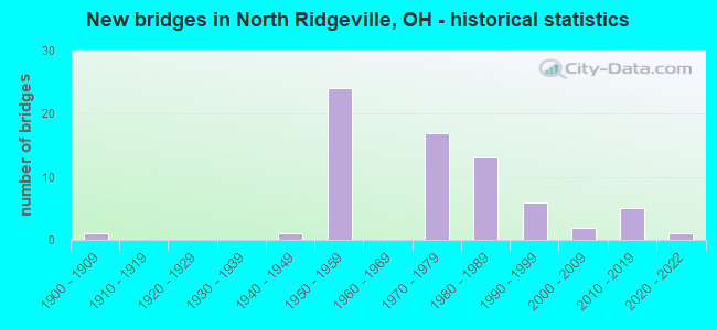
- New bridges - historical statistics
- 11900-1909
- 11940-1949
- 241950-1959
- 171970-1979
- 131980-1989
- 61990-1999
- 22000-2009
- 52010-2019
- 12020-2022

- Reconstructed bridges - Historical Statistics
- 11920-1929
- 01930-1939
- 01940-1949
- 01950-1959
- 01960-1969
- 31970-1979
- 41980-1989
- 51990-1999
- 12000-2009


- Bridge Condition - Deck
- 15.4%Excellent
- 2.6%Very good
- 66.7%Good
- 5.1%Satisfactory
- 5.1%Fair
- 2.6%Poor
- 2.6%Serious

- Bridge Condition - Superstructure
- 12.8%Excellent
- 7.7%Very good
- 56.4%Good
- 12.8%Satisfactory
- 7.7%Fair
- 2.6%Serious

- Bridge Condition - Substructure
- 15.4%Excellent
- 12.8%Very good
- 33.3%Good
- 28.2%Satisfactory
- 5.1%Fair
- 2.6%Poor
- 2.6%Serious

- Bridge Condition - Channel
- 26.3%Excellent
- 5.3%Very good
- 36.8%Good
- 21.1%Satisfactory
- 5.3%Fair
- 5.3%Poor

- Bridge Condition - Culverts
- 12.5%Excellent
- 25.0%Good
- 50.0%Satisfactory
- 12.5%Poor
Find on map >> Show street view
Structure Number: 4701399, Location: 4.28 MILES EAST OF SR 57 (Lat: 41.369439, Lng: -82.001869), Route carried "on" structure: State highway 10, Year Built: 1978, Status: Open, Structure Length: 0.73m (2.40ft), Average Daily Traffic: 34,875 (year 2015), Truck Traffic: 10%, Average Future Daily Traffic: 48,407 (year 2035), Design Load: HS 20+Mod, Features Intersected: FRENCH CREEK
Minimum Vertical Clearance: 30+ m (98+ ft), Kilometerpoint: 6.888, Lanes on structure: 4, Base Highway Network: Yes, Owner: State Highway Agency, Approaching Roadway Width: 32.9m (107.9ft), Material/Design: Concrete, Design/Construction: Culvert, Number Of Spans In Main Unit: 2, Length of Maximum Span: 2.7m (8.9ft)
Condition: Channel: Satisfactory, Culverts: Satisfactory, Operating Rating: 42.1 metric tons, Method Used To Determine Operating Rating: Load Factor (LF) rating reported by rating factor (RF) method using MS18 loading, Inventory Rating: 32.4 metric tons, Method Used To Determine Inventory Rating: Load Factor (LF) rating reported by rating factor (RF) method using MS18 loading, Structural Evaluation: Equal to present minimum criteria, Waterway Adequacy: Equal to present desirable criteria, Approach Roadway Alignment: Better than present minimum criteria, Designated Inspection Frequency: Every 12 months, Inspection Date: December 2021
Find on map >> Show street view
Structure Number: 4701496, Location: 5.05 MILES EAST OF SR 57 (Lat: 41.378361, Lng: -81.990669), Route carried "on" structure: State highway 10, Year Built: 1979, Status: Open, Structure Length: 15.00m (49.21ft), Average Daily Traffic: 17,438 (year 2015), Truck Traffic: 10%, Average Future Daily Traffic: 24,204 (year 2035), Design Load: HS 20+Mod, Features Intersected: I80 OHIO TURNPIKE
Minimum Vertical Clearance: 30+ m (98+ ft), Kilometerpoint: 8.127, Lanes on structure: 2, Lanes under structure: 6, Base Highway Network: Yes, Owner: State Highway Agency, Approaching Roadway Width: 8.7m (28.5ft), Skew: 2 degrees, Material/Design: Steel continuous, Design/Construction: Stringer/Multi-beam, Number Of Spans In Main Unit: 5, Length of Maximum Span: 34.1m (111.9ft), Curb-To-Curb Width: 12.2m (40.0ft), Out-to-Out Width: 12.9m (42.3ft)
Condition: Deck: Good, Superstructure: Satisfactory, Substructure: Good, Operating Rating: 45.4 metric tons, Method Used To Determine Operating Rating: Load and Resistance Factor Rating (LRFR) rating reported by rating factor(RF) method using HL-93 loadings, Inventory Rating: 35.6 metric tons, Method Used To Determine Inventory Rating: Load and Resistance Factor Rating (LRFR) rating reported by rating factor(RF) method using HL-93 loadings, Structural Evaluation: Equal to present minimum criteria, Deck Geometry: Better than present minimum criteria, Underclear: High priority of corrective action, Approach Roadway Alignment: Equal to present desirable criteria, Designated Inspection Frequency: Every 12 months, Inspection Date: July 2021, Deck Structure Type: Concrete Cast-file-Place, Wearing Surface/Protective System: Wearing Surface: Monolithic Concrete, Deck Protection: Epoxy Coated Reinforcing
Find on map >> Show street view
Structure Number: 4701518, Location: 5.05 MILES EAST OF SR 57 (Lat: 41.378481, Lng: -81.990850), Route carried "on" structure: State highway 10, Year Built: 1979, Status: Open, Structure Length: 13.78m (45.21ft), Average Daily Traffic: 17,438 (year 2015), Truck Traffic: 10%, Average Future Daily Traffic: 24,204 (year 2035), Design Load: HS 20+Mod, Features Intersected: I80 OHIO TURNPIKE
Minimum Vertical Clearance: 30+ m (98+ ft), Kilometerpoint: 8.127, Lanes on structure: 2, Lanes under structure: 6, Base Highway Network: Yes, Owner: State Highway Agency, Approaching Roadway Width: 8.7m (28.5ft), Skew: 2 degrees, Material/Design: Steel continuous, Design/Construction: Stringer/Multi-beam, Number Of Spans In Main Unit: 5, Length of Maximum Span: 33.2m (108.9ft), Curb-To-Curb Width: 11.7m (38.4ft), Out-to-Out Width: 12.1m (39.7ft)
Condition: Deck: Good, Superstructure: Satisfactory, Substructure: Satisfactory, Operating Rating: 45.4 metric tons, Method Used To Determine Operating Rating: Load and Resistance Factor Rating (LRFR) rating reported by rating factor(RF) method using HL-93 loadings, Inventory Rating: 32.4 metric tons, Method Used To Determine Inventory Rating: Load and Resistance Factor Rating (LRFR) rating reported by rating factor(RF) method using HL-93 loadings, Structural Evaluation: Equal to present minimum criteria, Deck Geometry: Equal to present minimum criteria, Underclear: Meets minimum limits, Approach Roadway Alignment: Equal to present desirable criteria, Designated Inspection Frequency: Every 12 months, Inspection Date: July 2021, Deck Structure Type: Concrete Cast-file-Place, Wearing Surface/Protective System: Wearing Surface: Monolithic Concrete, Deck Protection: Epoxy Coated Reinforcing
Find on map >> Show street view
Structure Number: 4702221, Location: .5 MI E OF IR-80 TPK (Lat: 41.383411, Lng: -82.056950), Route carried "on" structure: US 20, Year Built: 2019, Status: Open, Structure Length: 2.82m (9.25ft), Average Daily Traffic: 12,220 (year 2019), Truck Traffic: 6%, Average Future Daily Traffic: 16,961 (year 2039), Design Load: HL 93, Features Intersected: RIDGEWAY DITCH
Minimum Vertical Clearance: 30+ m (98+ ft), Kilometerpoint: 32.943, Lanes on structure: 3, Base Highway Network: Yes, Owner: State Highway Agency, Approaching Roadway Width: 11.6m (38.1ft), Material/Design: Concrete continuous, Design/Construction: Slab, Number Of Spans In Main Unit: 3, Length of Maximum Span: 10.7m (35.1ft), Curb or Sidewalk Widths: Left: 1.8m (5.9ft), Right: 4.0m (13.1ft), Curb-To-Curb Width: 11.6m (38.1ft), Out-to-Out Width: 18.6m (61.0ft)
Condition: Deck: Excellent, Superstructure: Excellent, Substructure: Excellent, Channel: Excellent, Operating Rating: 51.8 metric tons, Method Used To Determine Operating Rating: Load and Resistance Factor Rating (LRFR) rating reported by rating factor(RF) method using HL-93 loadings, Inventory Rating: 42.1 metric tons, Method Used To Determine Inventory Rating: Load and Resistance Factor Rating (LRFR) rating reported by rating factor(RF) method using HL-93 loadings, Structural Evaluation: Superior to present desirable criteria, Deck Geometry: High priority of replacement, Waterway Adequacy: Equal to present desirable criteria, Approach Roadway Alignment: Equal to present desirable criteria, Designated Inspection Frequency: Every 12 months, Inspection Date: November 2021, Deck Structure Type: Concrete Cast-file-Place, Wearing Surface/Protective System: Wearing Surface: Monolithic Concrete, Membrane: Other, Deck Protection: Epoxy Coated Reinforcing
Find on map >> Show street view
Structure Number: 4702344, Location: 3.73 MILES EAST OF SR 83 (Lat: 41.408050, Lng: -81.978989), Route carried "on" structure: US 20, Year Built: 1900, Year Reconstructed: 1932, Status: Open, Structure Length: 0.68m (2.23ft), Average Daily Traffic: 18,369 (year 2015), Truck Traffic: 2%, Average Future Daily Traffic: 25,496 (year 2035), Design Load: H 15, Features Intersected: TRIB OF FRENCH CREEK
Minimum Vertical Clearance: 30+ m (98+ ft), Kilometerpoint: 40.234, Lanes on structure: 3, Base Highway Network: Yes, Owner: State Highway Agency, Approaching Roadway Width: 12.2m (40.0ft), Material/Design: Masonry, Design/Construction: Culvert, Number Of Spans In Main Unit: 1, Length of Maximum Span: 4.9m (16.1ft)
Condition: Channel: Fair, Culverts: Poor, Operating Rating: 40.8 metric tons, Method Used To Determine Operating Rating: Field evaluation and documented engineering judgment, Inventory Rating: 32.7 metric tons, Method Used To Determine Inventory Rating: Field evaluation and documented engineering judgment, Structural Evaluation: Meets minimum limits, Waterway Adequacy: Equal to present desirable criteria, Approach Roadway Alignment: Equal to present desirable criteria, Designated Inspection Frequency: Every 12 months, Other Special Inspection Frequency: Every 6 months, Inspection Date: November 2021, Other Special Inspection Date: November 2021
Find on map >> Show street view
Structure Number: 4704096, Location: 2.4 MI. NORTH OF SR.82 (Lat: 41.348950, Lng: -82.019811), Route carried "on" structure: State highway 83, Year Built: 2009, Status: Open, Structure Length: 2.25m (7.38ft), Average Daily Traffic: 7,485 (year 2015), Truck Traffic: 12%, Average Future Daily Traffic: 10,389 (year 2035), Design Load: HS 20+Mod, Features Intersected: CARPENTER DITCH
Minimum Vertical Clearance: 30+ m (98+ ft), Kilometerpoint: 16.608, Lanes on structure: 2, Owner: State Highway Agency, Approaching Roadway Width: 12.8m (42.0ft), Skew: 4 degrees, Material/Design: Concrete continuous, Design/Construction: Slab, Number Of Spans In Main Unit: 3, Length of Maximum Span: 9.1m (29.9ft), Curb-To-Curb Width: 12.2m (40.0ft), Out-to-Out Width: 12.2m (40.0ft)
Condition: Deck: Excellent, Superstructure: Excellent, Substructure: Excellent, Channel: Excellent, Operating Rating: 68.0 metric tons, Method Used To Determine Operating Rating: Allowable Stress (AS) rating reported by rating factor (RF) method using MS18 loading, Inventory Rating: 42.1 metric tons, Method Used To Determine Inventory Rating: Allowable Stress (AS) rating reported by rating factor (RF) method using MS18 loading, Structural Evaluation: Superior to present desirable criteria, Deck Geometry: Somewhat better than minimum adequacy, Waterway Adequacy: Equal to present desirable criteria, Approach Roadway Alignment: Equal to present desirable criteria, Designated Inspection Frequency: Every 24 months, Inspection Date: December 2021, Deck Structure Type: Concrete Cast-file-Place, Wearing Surface/Protective System: Wearing Surface: Monolithic Concrete, Deck Protection: Epoxy Coated Reinforcing
Find on map >> Show street view
Structure Number: 4704118, Location: 2.59 MILES EAST OF SR 57 (Lat: 41.353019, Lng: -82.025431), Route carried "on" structure: Spur State highway 83C, Year Built: 1979, Status: Open, Structure Length: 6.13m (20.11ft), Average Daily Traffic: 5,710 (year 2015), Truck Traffic: 7%, Average Future Daily Traffic: 7,925 (year 2035), Design Load: HS 20+Mod, Features Intersected: OVER LOR-10-0253
Minimum Vertical Clearance: 30+ m (98+ ft), Kilometerpoint: 0.692, Lanes on structure: 2, Lanes under structure: 4, Owner: State Highway Agency, Approaching Roadway Width: 13.1m (43.0ft), Material/Design: Steel continuous, Design/Construction: Stringer/Multi-beam, Number Of Spans In Main Unit: 4, Length of Maximum Span: 17.7m (58.1ft), Curb-To-Curb Width: 12.9m (42.3ft), Out-to-Out Width: 14.1m (46.3ft)
Condition: Deck: Good, Superstructure: Good, Substructure: Good, Operating Rating: 48.6 metric tons, Method Used To Determine Operating Rating: Load and Resistance Factor Rating (LRFR) rating reported by rating factor(RF) method using HL-93 loadings, Inventory Rating: 38.9 metric tons, Method Used To Determine Inventory Rating: Load and Resistance Factor Rating (LRFR) rating reported by rating factor(RF) method using HL-93 loadings, Structural Evaluation: Better than present minimum criteria, Deck Geometry: Somewhat better than minimum adequacy, Underclear: Meets minimum limits, Approach Roadway Alignment: Equal to present desirable criteria, Designated Inspection Frequency: Every 24 months, Inspection Date: December 2021, Deck Structure Type: Concrete Cast-file-Place, Wearing Surface/Protective System: Wearing Surface: Monolithic Concrete, Deck Protection: Epoxy Coated Reinforcing
Find on map >> Show street view
Structure Number: 4704126, Location: 1 MILE SOUTH OF US 20 (Lat: 41.375269, Lng: -82.020911), Route carried "on" structure: State highway 83, Year Built: 2006, Status: Open, Structure Length: 7.32m (24.02ft), Average Daily Traffic: 6,159 (year 2015), Truck Traffic: 14%, Average Future Daily Traffic: 8,549 (year 2035), Design Load: HS 25 or greater, Features Intersected: OVER N & S RAILROAD
Minimum Vertical Clearance: 30+ m (98+ ft), Kilometerpoint: 19.586, Lanes on structure: 2, Owner: State Highway Agency, Approaching Roadway Width: 16.2m (53.1ft), Material/Design: Prestressed concrete continuous, Design/Construction: Box Beam or Girders - Multiple, Number Of Spans In Main Unit: 3, Length of Maximum Span: 29.6m (97.1ft), Curb-To-Curb Width: 15.2m (49.9ft), Out-to-Out Width: 16.2m (53.1ft)
Condition: Deck: Very good, Superstructure: Very good, Substructure: Excellent, Operating Rating: 42.1 metric tons, Method Used To Determine Operating Rating: Load Factor (LF) rating reported by rating factor (RF) method using MS18 loading, Inventory Rating: 32.4 metric tons, Method Used To Determine Inventory Rating: Load Factor (LF) rating reported by rating factor (RF) method using MS18 loading, Structural Evaluation: Equal to present desirable criteria, Deck Geometry: Superior to present desirable criteria, Underclear: Superior to present desirable criteria, Approach Roadway Alignment: Equal to present desirable criteria, Designated Inspection Frequency: Every 24 months, Inspection Date: August 2021, Deck Structure Type: Concrete Cast-file-Place, Wearing Surface/Protective System: Wearing Surface: Monolithic Concrete, Deck Protection: Epoxy Coated Reinforcing
Find on map >> Show street view
Structure Number: 4707559, Location: 1.05 MI E OF OHIO TNPK (Lat: 41.382931, Lng: -81.988450), Route carried "on" structure: Interstate 480, Year Built: 1980, Status: Open, Structure Length: 5.70m (18.70ft), Average Daily Traffic: 8,955 (year 2015), Truck Traffic: 16%, Average Future Daily Traffic: 12,430 (year 2035), Design Load: HS 20, Features Intersected: OVER CHESNUT RIDGE CH-25
Minimum Vertical Clearance: 30+ m (98+ ft), Kilometerpoint: 1.851, Lanes on structure: 2, Lanes under structure: 2, Base Highway Network: Yes, Owner: State Highway Agency, Approaching Roadway Width: 11.6m (38.1ft), Skew: 5 degrees, Material/Design: Steel continuous, Design/Construction: Stringer/Multi-beam, Number Of Spans In Main Unit: 3, Length of Maximum Span: 21.3m (69.9ft), Curb-To-Curb Width: 12.6m (41.3ft), Out-to-Out Width: 13.5m (44.3ft)
Condition: Deck: Good, Superstructure: Good, Substructure: Good, Operating Rating: 45.4 metric tons, Method Used To Determine Operating Rating: Load and Resistance Factor Rating (LRFR) rating reported by rating factor(RF) method using HL-93 loadings, Inventory Rating: 35.6 metric tons, Method Used To Determine Inventory Rating: Load and Resistance Factor Rating (LRFR) rating reported by rating factor(RF) method using HL-93 loadings, Structural Evaluation: Better than present minimum criteria, Deck Geometry: Better than present minimum criteria, Underclear: Meets minimum limits, Approach Roadway Alignment: Equal to present desirable criteria, Designated Inspection Frequency: Every 24 months, Inspection Date: July 2021, Deck Structure Type: Concrete Cast-file-Place, Wearing Surface/Protective System: Wearing Surface: Monolithic Concrete, Deck Protection: Epoxy Coated Reinforcing
Find on map >> Show street view
Structure Number: 4707567, Location: .2 MI. WEST OF RT.10 (Lat: 41.381750, Lng: -81.989319), Route carried "on" structure: Interstate 480, Year Built: 1980, Status: Open, Structure Length: 4.30m (14.11ft), Average Daily Traffic: 8,955 (year 2015), Truck Traffic: 16%, Average Future Daily Traffic: 12,430 (year 2035), Design Load: HS 20, Features Intersected: OVER CHESNUT RIDGE CH-25
Minimum Vertical Clearance: 30+ m (98+ ft), Kilometerpoint: 1.690, Lanes on structure: 2, Lanes under structure: 2, Base Highway Network: Yes, Owner: State Highway Agency, Approaching Roadway Width: 11.6m (38.1ft), Skew: 4 degrees, Material/Design: Steel continuous, Design/Construction: Stringer/Multi-beam, Number Of Spans In Main Unit: 3, Length of Maximum Span: 15.2m (49.9ft), Curb-To-Curb Width: 10.1m (33.1ft), Out-to-Out Width: 13.5m (44.3ft)
Condition: Deck: Good, Superstructure: Good, Substructure: Good, Operating Rating: 51.8 metric tons, Method Used To Determine Operating Rating: Load and Resistance Factor Rating (LRFR) rating reported by rating factor(RF) method using HL-93 loadings, Inventory Rating: 38.9 metric tons, Method Used To Determine Inventory Rating: Load and Resistance Factor Rating (LRFR) rating reported by rating factor(RF) method using HL-93 loadings, Structural Evaluation: Better than present minimum criteria, Deck Geometry: High priority of corrective action, Underclear: Somewhat better than minimum adequacy, Approach Roadway Alignment: Superior to present desirable criteria, Designated Inspection Frequency: Every 24 months, Inspection Date: July 2021, Deck Structure Type: Concrete Cast-file-Place, Wearing Surface/Protective System: Wearing Surface: Monolithic Concrete, Deck Protection: Epoxy Coated Reinforcing
Find on map >> Show street view
Structure Number: 4707583, Location: .45 MI W OF CUY CO LINE (Lat: 41.387119, Lng: -81.978881), Route carried "on" structure: Interstate 480, Year Built: 1980, Status: Open, Structure Length: 4.33m (14.21ft), Average Daily Traffic: 54,153 (year 2015), Truck Traffic: 11%, Average Future Daily Traffic: 75,164 (year 2035), Design Load: HS 20+Mod, Features Intersected: OVER LEAR NAGLE TH-55
Minimum Vertical Clearance: 30+ m (98+ ft), Kilometerpoint: 2.768, Lanes on structure: 6, Lanes under structure: 2, Base Highway Network: Yes, Owner: State Highway Agency, Approaching Roadway Width: 37.2m (122.0ft), Skew: 30 degrees, Material/Design: Steel continuous, Design/Construction: Stringer/Multi-beam, Number Of Spans In Main Unit: 3, Length of Maximum Span: 20.7m (67.9ft), Curb-To-Curb Width: 37.2m (122.0ft), Out-to-Out Width: 38.1m (125.0ft)
Condition: Deck: Good, Superstructure: Very good, Substructure: Very good, Operating Rating: 48.6 metric tons, Method Used To Determine Operating Rating: Load and Resistance Factor Rating (LRFR) rating reported by rating factor(RF) method using HL-93 loadings, Inventory Rating: 38.9 metric tons, Method Used To Determine Inventory Rating: Load and Resistance Factor Rating (LRFR) rating reported by rating factor(RF) method using HL-93 loadings, Structural Evaluation: Equal to present desirable criteria, Deck Geometry: Superior to present desirable criteria, Underclear: High priority of corrective action, Approach Roadway Alignment: Equal to present desirable criteria, Designated Inspection Frequency: Every 24 months, Inspection Date: July 2021, Deck Structure Type: Concrete Cast-file-Place, Wearing Surface/Protective System: Wearing Surface: Monolithic Concrete, Deck Protection: Epoxy Coated Reinforcing
Find on map >> Show street view
Structure Number: 4707591, Location: 1.21 MILES E OF OHIO TNPK (Lat: 41.382269, Lng: -81.987239), Route carried "on" structure: Interstate 480, Year Built: 1980, Status: Open, Structure Length: 6.61m (21.69ft), Average Daily Traffic: 8,955 (year 2015), Truck Traffic: 16%, Average Future Daily Traffic: 12,430 (year 2035), Design Load: HS 20+Mod, Features Intersected: OVER LOR-010-0546
Minimum Vertical Clearance: 30+ m (98+ ft), Kilometerpoint: 1.947, Lanes on structure: 2, Lanes under structure: 2, Base Highway Network: Yes, Owner: State Highway Agency, Approaching Roadway Width: 11.6m (38.1ft), Skew: 5 degrees, Material/Design: Steel continuous, Design/Construction: Stringer/Multi-beam, Number Of Spans In Main Unit: 3, Length of Maximum Span: 24.7m (81.0ft), Curb-To-Curb Width: 12.5m (41.0ft), Out-to-Out Width: 13.5m (44.3ft)
Condition: Deck: Good, Superstructure: Very good, Substructure: Good, Operating Rating: 45.4 metric tons, Method Used To Determine Operating Rating: Load and Resistance Factor Rating (LRFR) rating reported by rating factor(RF) method using HL-93 loadings, Inventory Rating: 35.6 metric tons, Method Used To Determine Inventory Rating: Load and Resistance Factor Rating (LRFR) rating reported by rating factor(RF) method using HL-93 loadings, Structural Evaluation: Better than present minimum criteria, Deck Geometry: Better than present minimum criteria, Underclear: Meets minimum limits, Approach Roadway Alignment: Equal to present desirable criteria, Designated Inspection Frequency: Every 24 months, Inspection Date: July 2021, Deck Structure Type: Concrete Cast-file-Place, Wearing Surface/Protective System: Wearing Surface: Monolithic Concrete, Deck Protection: Epoxy Coated Reinforcing
Find on map >> Show street view
Structure Number: 4707613, Location: .08 MILES WEST OF CUY CO (Lat: 41.388381, Lng: -81.973081), Route carried "on" structure: Interstate 480, Year Built: 1980, Status: Open, Structure Length: 7.77m (25.49ft), Average Daily Traffic: 54,153 (year 2015), Truck Traffic: 11%, Average Future Daily Traffic: 75,164 (year 2035), Design Load: HS 20+Mod, Features Intersected: OVER LOR-10-0659
Minimum Vertical Clearance: 30+ m (98+ ft), Kilometerpoint: 3.267, Lanes on structure: 7, Lanes under structure: 4, Base Highway Network: Yes, Owner: State Highway Agency, Approaching Roadway Width: 39.6m (129.9ft), Skew: 35 degrees, Material/Design: Steel continuous, Design/Construction: Stringer/Multi-beam, Number Of Spans In Main Unit: 4, Length of Maximum Span: 22.3m (73.2ft), Curb-To-Curb Width: 37.2m (122.0ft), Out-to-Out Width: 40.5m (132.9ft)
Condition: Deck: Good, Superstructure: Good, Substructure: Good, Operating Rating: 38.9 metric tons, Method Used To Determine Operating Rating: Load and Resistance Factor Rating (LRFR) rating reported by rating factor(RF) method using HL-93 loadings, Inventory Rating: 29.2 metric tons, Method Used To Determine Inventory Rating: Load and Resistance Factor Rating (LRFR) rating reported by rating factor(RF) method using HL-93 loadings, Structural Evaluation: Better than present minimum criteria, Deck Geometry: Superior to present desirable criteria, Underclear: High priority of corrective action, Approach Roadway Alignment: Equal to present desirable criteria, Designated Inspection Frequency: Every 24 months, Inspection Date: July 2021, Deck Structure Type: Concrete Cast-file-Place, Wearing Surface/Protective System: Wearing Surface: Monolithic Concrete, Deck Protection: Epoxy Coated Reinforcing
Find on map >> Show street view
Structure Number: 4708431, Location: 2.86 MILES NORTH OF SR 82 (Lat: 41.355531, Lng: -82.019361), Route carried "on" structure: State highway 83, Year Built: 1979, Status: Open, Structure Length: 8.41m (27.59ft), Average Daily Traffic: 6,159 (year 2015), Truck Traffic: 14%, Average Future Daily Traffic: 8,549 (year 2035), Design Load: HS 20+Mod, Features Intersected: OVER LOR-10-0296
Minimum Vertical Clearance: 30+ m (98+ ft), Kilometerpoint: 17.349, Lanes on structure: 2, Lanes under structure: 4, Owner: State Highway Agency, Approaching Roadway Width: 13.4m (44.0ft), Skew: 4 degrees, Material/Design: Steel continuous, Design/Construction: Stringer/Multi-beam, Number Of Spans In Main Unit: 4, Length of Maximum Span: 24.4m (80.1ft), Curb-To-Curb Width: 13.0m (42.7ft), Out-to-Out Width: 14.1m (46.3ft)
Condition: Deck: Poor, Superstructure: Good, Substructure: Satisfactory, Operating Rating: 42.1 metric tons, Method Used To Determine Operating Rating: Allowable Stress (AS) rating reported by rating factor (RF) method using MS18 loading, Inventory Rating: 32.4 metric tons, Method Used To Determine Inventory Rating: Allowable Stress (AS) rating reported by rating factor (RF) method using MS18 loading, Structural Evaluation: Equal to present minimum criteria, Deck Geometry: Somewhat better than minimum adequacy, Underclear: High priority of corrective action, Approach Roadway Alignment: Equal to present desirable criteria, Designated Inspection Frequency: Every 12 months, Inspection Date: December 2021, Deck Structure Type: Concrete Cast-file-Place, Wearing Surface/Protective System: Wearing Surface: Monolithic Concrete, Membrane: Other, Deck Protection: Epoxy Coated Reinforcing
Find on map >> Show street view
Structure Number: 4708474, Location: 4.36 MILES EAST OF SR 57 (Lat: 41.371019, Lng: -82.000019), Route carried "on" structure: State highway 10, Year Built: 1979, Status: Open, Structure Length: 3.90m (12.80ft), Average Daily Traffic: 17,438 (year 2015), Truck Traffic: 10%, Average Future Daily Traffic: 24,204 (year 2035), Design Load: HS 20+Mod, Features Intersected: OVER ROOT ROAD TH-24
Minimum Vertical Clearance: 30+ m (98+ ft), Kilometerpoint: 7.017, Lanes on structure: 2, Lanes under structure: 2, Base Highway Network: Yes, Owner: State Highway Agency, Approaching Roadway Width: 8.7m (28.5ft), Skew: 1 degrees, Material/Design: Concrete continuous, Design/Construction: Slab, Number Of Spans In Main Unit: 3, Length of Maximum Span: 14.9m (48.9ft), Curb-To-Curb Width: 12.1m (39.7ft), Out-to-Out Width: 12.9m (42.3ft)
Condition: Deck: Good, Superstructure: Good, Substructure: Fair, Operating Rating: 64.8 metric tons, Method Used To Determine Operating Rating: Load Factor (LF) rating reported by rating factor (RF) method using MS18 loading, Inventory Rating: 38.9 metric tons, Method Used To Determine Inventory Rating: Load Factor (LF) rating reported by rating factor (RF) method using MS18 loading, Structural Evaluation: Somewhat better than minimum adequacy, Deck Geometry: Equal to present minimum criteria, Underclear: Meets minimum limits, Approach Roadway Alignment: Equal to present desirable criteria, Designated Inspection Frequency: Every 12 months, Inspection Date: December 2021, Deck Structure Type: Concrete Cast-file-Place, Wearing Surface/Protective System: Wearing Surface: Monolithic Concrete, Deck Protection: Epoxy Coated Reinforcing
Find on map >> Show street view
Structure Number: 4708482, Location: 4.36 MILES EAST OF SR 57 (Lat: 41.370900, Lng: -81.999900), Route carried "on" structure: State highway 10, Year Built: 1979, Status: Open, Structure Length: 3.90m (12.80ft), Average Daily Traffic: 17,438 (year 2015), Truck Traffic: 10%, Average Future Daily Traffic: 24,204 (year 2035), Design Load: HS 20+Mod, Features Intersected: OVER ROOT ROAD TH-24
Minimum Vertical Clearance: 30+ m (98+ ft), Kilometerpoint: 7.017, Lanes on structure: 2, Lanes under structure: 2, Base Highway Network: Yes, Owner: State Highway Agency, Approaching Roadway Width: 8.7m (28.5ft), Skew: 1 degrees, Material/Design: Concrete continuous, Design/Construction: Slab, Number Of Spans In Main Unit: 3, Length of Maximum Span: 14.9m (48.9ft), Curb-To-Curb Width: 12.1m (39.7ft), Out-to-Out Width: 12.9m (42.3ft)
Condition: Deck: Good, Superstructure: Good, Substructure: Satisfactory, Operating Rating: 64.8 metric tons, Method Used To Determine Operating Rating: Load Factor (LF) rating reported by rating factor (RF) method using MS18 loading, Inventory Rating: 38.9 metric tons, Method Used To Determine Inventory Rating: Load Factor (LF) rating reported by rating factor (RF) method using MS18 loading, Structural Evaluation: Equal to present minimum criteria, Deck Geometry: Equal to present minimum criteria, Underclear: Meets minimum limits, Approach Roadway Alignment: Equal to present desirable criteria, Designated Inspection Frequency: Every 12 months, Inspection Date: December 2021, Deck Structure Type: Concrete Cast-file-Place, Wearing Surface/Protective System: Wearing Surface: Monolithic Concrete, Deck Protection: Epoxy Coated Reinforcing
Find on map >> Show street view
Structure Number: 4708512, Location: 4.76 MILES EAST OF SR 57 (Lat: 41.375319, Lng: -81.994750), Route carried "on" structure: State highway 10, Year Built: 1979, Status: Open, Structure Length: 8.05m (26.41ft), Average Daily Traffic: 17,438 (year 2015), Truck Traffic: 10%, Average Future Daily Traffic: 24,204 (year 2035), Design Load: HS 20+Mod, Features Intersected: OVER NORFOLK SOUTHERN R/
Minimum Vertical Clearance: 30+ m (98+ ft), Kilometerpoint: 7.660, Lanes on structure: 2, Base Highway Network: Yes, Owner: State Highway Agency, Approaching Roadway Width: 8.7m (28.5ft), Skew: 4 degrees, Material/Design: Steel continuous, Design/Construction: Stringer/Multi-beam, Number Of Spans In Main Unit: 3, Length of Maximum Span: 33.2m (108.9ft), Curb-To-Curb Width: 12.1m (39.7ft), Out-to-Out Width: 12.9m (42.3ft)
Condition: Deck: Good, Superstructure: Good, Substructure: Satisfactory, Operating Rating: 45.4 metric tons, Method Used To Determine Operating Rating: Load and Resistance Factor Rating (LRFR) rating reported by rating factor(RF) method using HL-93 loadings, Inventory Rating: 35.6 metric tons, Method Used To Determine Inventory Rating: Load and Resistance Factor Rating (LRFR) rating reported by rating factor(RF) method using HL-93 loadings, Structural Evaluation: Equal to present minimum criteria, Deck Geometry: Equal to present minimum criteria, Underclear: Better than present minimum criteria, Approach Roadway Alignment: Equal to present desirable criteria, Designated Inspection Frequency: Every 12 months, Inspection Date: December 2021, Deck Structure Type: Concrete Cast-file-Place, Wearing Surface/Protective System: Wearing Surface: Monolithic Concrete, Deck Protection: Epoxy Coated Reinforcing
Find on map >> Show street view
Structure Number: 470852, Location: 4.76 MILES EAST OF SR 57 (Lat: 41.375331, Lng: -81.994419), Route carried "on" structure: State highway 10, Year Built: 1979, Status: Open, Structure Length: 8.05m (26.41ft), Average Daily Traffic: 17,438 (year 2015), Truck Traffic: 10%, Average Future Daily Traffic: 24,204 (year 2035), Design Load: HS 20+Mod, Features Intersected: OVER NORFOLK SOUTHERN R/
Minimum Vertical Clearance: 30+ m (98+ ft), Kilometerpoint: 7.660, Lanes on structure: 2, Base Highway Network: Yes, Owner: State Highway Agency, Approaching Roadway Width: 8.7m (28.5ft), Skew: 4 degrees, Material/Design: Steel continuous, Design/Construction: Stringer/Multi-beam, Number Of Spans In Main Unit: 3, Length of Maximum Span: 33.2m (108.9ft), Curb-To-Curb Width: 12.1m (39.7ft), Out-to-Out Width: 12.9m (42.3ft)
Condition: Deck: Good, Superstructure: Good, Substructure: Satisfactory, Operating Rating: 45.4 metric tons, Method Used To Determine Operating Rating: Load and Resistance Factor Rating (LRFR) rating reported by rating factor(RF) method using HL-93 loadings, Inventory Rating: 35.6 metric tons, Method Used To Determine Inventory Rating: Load and Resistance Factor Rating (LRFR) rating reported by rating factor(RF) method using HL-93 loadings, Structural Evaluation: Equal to present minimum criteria, Deck Geometry: Equal to present minimum criteria, Underclear: Better than present minimum criteria, Approach Roadway Alignment: Equal to present desirable criteria, Designated Inspection Frequency: Every 12 months, Inspection Date: December 2021, Deck Structure Type: Concrete Cast-file-Place, Wearing Surface/Protective System: Wearing Surface: Monolithic Concrete, Deck Protection: Epoxy Coated Reinforcing
Find on map >> Show street view
Structure Number: 4729617, Location: 2.5MI EAST OF EXIT 145 (Lat: 41.380681, Lng: -82.067019), Route carried "on" structure: Interstate 80K, Year Built: 1954, Year Reconstructed: 1996, Status: Open, Structure Length: 6.25m (20.51ft), Average Daily Traffic: 51,503 (year 2015), Truck Traffic: 14%, Average Future Daily Traffic: 71,486 (year 2035), Design Load: HS 20+Mod, Features Intersected: USR 20, Facility Carried by Structure: I80 OH TPK
Minimum Vertical Clearance: 30+ m (98+ ft), Kilometerpoint: 24.993, Lanes on structure: 6, Lanes under structure: 3, Base Highway Network: Yes, Toll: On toll road, Owner: State Toll Authority, Approaching Roadway Width: 36.6m (120.1ft), Skew: 33 degrees, Material/Design: Steel, Design/Construction: Stringer/Multi-beam, Number Of Spans In Main Unit: 3, Length of Maximum Span: 26.5m (86.9ft), Curb-To-Curb Width: 37.4m (122.7ft), Out-to-Out Width: 38.3m (125.7ft)
Condition: Deck: Good, Superstructure: Good, Substructure: Satisfactory, Operating Rating: 71.3 metric tons, Method Used To Determine Operating Rating: Load Factor (LF) rating reported by rating factor (RF) method using MS18 loading, Inventory Rating: 42.1 metric tons, Method Used To Determine Inventory Rating: Load Factor (LF) rating reported by rating factor (RF) method using MS18 loading, Structural Evaluation: Equal to present minimum criteria, Deck Geometry: Superior to present desirable criteria, Underclear: Equal to present minimum criteria, Approach Roadway Alignment: Equal to present desirable criteria, Designated Inspection Frequency: Every 12 months, Inspection Date: March 2021, Deck Structure Type: Concrete Cast-file-Place, Wearing Surface/Protective System: Wearing Surface: Monolithic Concrete, Deck Protection: Epoxy Coated Reinforcing
Find on map >> Show street view
Structure Number: 4729676, Location: 3.7MI EAST OF EXIT 8 (Lat: 41.378400, Lng: -82.044419), Route carried "on" structure: City street M0147, Year Built: 1954, Year Reconstructed: 1988, Status: Open, Structure Length: 6.07m (19.91ft), Average Daily Traffic: 1,295 (year 2015), Truck Traffic: 5%, Average Future Daily Traffic: 71,486 (year 2035), Design Load: HS 20+Mod, Features Intersected: I80 OHIO TPK, Facility Carried by Structure: RACE RD
Minimum Vertical Clearance: 30+ m (98+ ft), Kilometerpoint: 0.805, Lanes on structure: 2, Lanes under structure: 6, Owner: State Toll Authority, Approaching Roadway Width: 8.2m (26.9ft), Material/Design: Steel continuous, Design/Construction: Stringer/Multi-beam, Number Of Spans In Main Unit: 2, Number Of Approach Spans: 2, Length of Maximum Span: 20.1m (65.9ft), Curb-To-Curb Width: 8.1m (26.6ft), Out-to-Out Width: 9.1m (29.9ft)
Condition: Deck: Good, Superstructure: Fair, Substructure: Satisfactory, Operating Rating: 55.1 metric tons, Method Used To Determine Operating Rating: Load Factor (LF) rating reported by rating factor (RF) method using MS18 loading, Inventory Rating: 32.4 metric tons, Method Used To Determine Inventory Rating: Load Factor (LF) rating reported by rating factor (RF) method using MS18 loading, Structural Evaluation: Somewhat better than minimum adequacy, Deck Geometry: Meets minimum limits, Underclear: High priority of corrective action, Approach Roadway Alignment: Equal to present desirable criteria, Designated Inspection Frequency: Every 12 months, Inspection Date: July 2021, Deck Structure Type: Concrete Cast-file-Place, Wearing Surface/Protective System: Wearing Surface: Monolithic Concrete, Deck Protection: Epoxy Coated Reinforcing
Find on map >> Show street view
Structure Number: 4729692, Location: 4.3MI EAST OF EXIT 8 (Lat: 41.379461, Lng: -82.032511), Route carried "on" structure: Interstate 80K, Year Built: 1954, Status: Open, Structure Length: 1.22m (4.00ft), Average Daily Traffic: 51,503 (year 2015), Truck Traffic: 14%, Average Future Daily Traffic: 71,486 (year 2035), Features Intersected: RIDGEWAY DITCH, Facility Carried by Structure: I80 OH TPK
Minimum Vertical Clearance: 30+ m (98+ ft), Kilometerpoint: 26.345, Lanes on structure: 6, Base Highway Network: Yes, Toll: On toll road, Owner: State Toll Authority, Approaching Roadway Width: 37.8m (124.0ft), Skew: 33 degrees, Material/Design: Concrete, Design/Construction: Culvert, Number Of Spans In Main Unit: 2, Length of Maximum Span: 5.5m (18.0ft)
Condition: Channel: Good, Culverts: Satisfactory, Operating Rating: 77.8 metric tons, Method Used To Determine Operating Rating: Load Factor (LF) rating reported by rating factor (RF) method using MS18 loading, Inventory Rating: 48.6 metric tons, Method Used To Determine Inventory Rating: Load Factor (LF) rating reported by rating factor (RF) method using MS18 loading, Structural Evaluation: Equal to present minimum criteria, Waterway Adequacy: Better than present minimum criteria, Approach Roadway Alignment: Equal to present minimum criteria, Designated Inspection Frequency: Every 12 months, Inspection Date: July 2021
Find on map >> Show street view
Structure Number: 4729714, Location: 4.3MI EAST OF EXIT 8 (Lat: 41.379531, Lng: -82.031919), Route carried "on" structure: City street M0146, Year Built: 1954, Year Reconstructed: 1988, Status: Open, Structure Length: 5.88m (19.29ft), Average Daily Traffic: 1,295 (year 2015), Truck Traffic: 5%, Average Future Daily Traffic: 71,486 (year 2035), Design Load: HS 20+Mod, Features Intersected: I80 OHIO TPK, Facility Carried by Structure: MADDOCK RD
Minimum Vertical Clearance: 30+ m (98+ ft), Kilometerpoint: 0.290, Lanes on structure: 2, Lanes under structure: 6, Owner: State Toll Authority, Approaching Roadway Width: 8.2m (26.9ft), Material/Design: Steel continuous, Design/Construction: Stringer/Multi-beam, Number Of Spans In Main Unit: 2, Number Of Approach Spans: 2, Length of Maximum Span: 20.1m (65.9ft), Curb-To-Curb Width: 8.1m (26.6ft), Out-to-Out Width: 9.1m (29.9ft)
Condition: Deck: Good, Superstructure: Good, Substructure: Satisfactory, Operating Rating: 64.8 metric tons, Method Used To Determine Operating Rating: Load Factor (LF) rating reported by rating factor (RF) method using MS18 loading, Inventory Rating: 38.9 metric tons, Method Used To Determine Inventory Rating: Load Factor (LF) rating reported by rating factor (RF) method using MS18 loading, Structural Evaluation: Equal to present minimum criteria, Deck Geometry: Meets minimum limits, Underclear: High priority of corrective action, Approach Roadway Alignment: Equal to present desirable criteria, Designated Inspection Frequency: Every 12 months, Inspection Date: July 2021, Deck Structure Type: Concrete Cast-file-Place, Wearing Surface/Protective System: Wearing Surface: Monolithic Concrete, Deck Protection: Epoxy Coated Reinforcing
Find on map >> Show street view
Structure Number: 4729757, Location: 5MI EAST OF EXIT 9 (Lat: 41.379931, Lng: -82.018711), Route carried "on" structure: State highway 83, Year Built: 1954, Year Reconstructed: 1987, Status: Open, Structure Length: 5.88m (19.29ft), Average Daily Traffic: 6,159 (year 2015), Truck Traffic: 14%, Average Future Daily Traffic: 71,486 (year 2035), Design Load: HS 20, Features Intersected: I80 OHIO TPK
Minimum Vertical Clearance: 30+ m (98+ ft), Kilometerpoint: 20.052, Lanes on structure: 2, Lanes under structure: 6, Owner: State Toll Authority, Approaching Roadway Width: 8.5m (27.9ft), Material/Design: Steel continuous, Design/Construction: Stringer/Multi-beam, Number Of Spans In Main Unit: 2, Number Of Approach Spans: 2, Length of Maximum Span: 20.1m (65.9ft), Curb or Sidewalk Widths: Left: 0.0m, Right: 1.4m (4.6ft), Curb-To-Curb Width: 8.5m (27.9ft), Out-to-Out Width: 11.1m (36.4ft)
Condition: Deck: Excellent, Superstructure: Good, Substructure: Good, Operating Rating: 54.4 metric tons, Method Used To Determine Operating Rating: Load Factor (LF) rating reported by rating factor (RF) method using MS18 loading, Inventory Rating: 32.4 metric tons, Method Used To Determine Inventory Rating: Load Factor (LF) rating reported by rating factor (RF) method using MS18 loading, Structural Evaluation: Better than present minimum criteria, Deck Geometry: High priority of replacement, Underclear: High priority of corrective action, Approach Roadway Alignment: Equal to present desirable criteria, Designated Inspection Frequency: Every 24 months, Inspection Date: July 2021, Deck Structure Type: Concrete Cast-file-Place, Wearing Surface/Protective System: Wearing Surface: Monolithic Concrete, Deck Protection: Epoxy Coated Reinforcing
Find on map >> Show street view
Structure Number: 4729765, Location: 5.6MI EAST OF EXIT 8 (Lat: 41.379331, Lng: -82.006850), Route carried "on" structure: County highway C0024, Year Built: 1996, Status: Open, Structure Length: 8.23m (27.00ft), Average Daily Traffic: 5,854 (year 2015), Truck Traffic: 7%, Average Future Daily Traffic: 71,486 (year 2035), Design Load: HS 20+Mod, Features Intersected: OHIO TURNPIKE & I-480, Facility Carried by Structure: ROOT ROAD
Minimum Vertical Clearance: 30+ m (98+ ft), Kilometerpoint: 8.803, Lanes on structure: 2, Lanes under structure: 7, Owner: State Toll Authority, Approaching Roadway Width: 9.1m (29.9ft), Skew: 3 degrees, Material/Design: Steel continuous, Design/Construction: Stringer/Multi-beam, Number Of Spans In Main Unit: 2, Length of Maximum Span: 45.7m (149.9ft), Curb-To-Curb Width: 9.1m (29.9ft), Out-to-Out Width: 10.1m (33.1ft)
Condition: Deck: Good, Superstructure: Good, Substructure: Good, Operating Rating: 61.6 metric tons, Method Used To Determine Operating Rating: Load Factor (LF) rating reported by rating factor (RF) method using MS18 loading, Inventory Rating: 35.6 metric tons, Method Used To Determine Inventory Rating: Load Factor (LF) rating reported by rating factor (RF) method using MS18 loading, Structural Evaluation: Better than present minimum criteria, Deck Geometry: Meets minimum limits, Underclear: Meets minimum limits, Approach Roadway Alignment: Equal to present minimum criteria, Designated Inspection Frequency: Every 24 months, Inspection Date: July 2021, Deck Structure Type: Concrete Cast-file-Place, Wearing Surface/Protective System: Wearing Surface: Monolithic Concrete, Deck Protection: Epoxy Coated Reinforcing
Find on map >> Show street view
Structure Number: 4729781, Location: .9 MI WEST OF RT.10 (Lat: 41.378639, Lng: -82.003931), Route carried "on" structure: Interstate 480, Year Built: 1980, Status: Open, Structure Length: 0.94m (3.08ft), Average Daily Traffic: 8,955 (year 2015), Truck Traffic: 16%, Average Future Daily Traffic: 12,430 (year 2035), Design Load: HS 20+Mod, Features Intersected: DRAINAGE DITCH
Minimum Vertical Clearance: 30+ m (98+ ft), Kilometerpoint: 0.547, Lanes on structure: 2, Base Highway Network: Yes, Toll: On toll road, Owner: State Toll Authority, Approaching Roadway Width: 11.6m (38.1ft), Skew: 1 degrees, Material/Design: Concrete, Design/Construction: Slab, Number Of Spans In Main Unit: 1, Length of Maximum Span: 8.5m (27.9ft), Curb-To-Curb Width: 13.4m (44.0ft), Out-to-Out Width: 13.4m (44.0ft)
Condition: Deck: Fair, Superstructure: Fair, Substructure: Poor, Channel: Good, Operating Rating: 77.8 metric tons, Method Used To Determine Operating Rating: Load Factor (LF) rating reported by rating factor (RF) method using MS18 loading, Inventory Rating: 48.6 metric tons, Method Used To Determine Inventory Rating: Load Factor (LF) rating reported by rating factor (RF) method using MS18 loading, Structural Evaluation: Meets minimum limits, Deck Geometry: Superior to present desirable criteria, Waterway Adequacy: Equal to present desirable criteria, Approach Roadway Alignment: Equal to present desirable criteria, Designated Inspection Frequency: Every 12 months, Inspection Date: July 2021, Deck Structure Type: Concrete Cast-file-Place, Wearing Surface/Protective System: Wearing Surface: Monolithic Concrete, Deck Protection: Epoxy Coated Reinforcing
Find on map >> Show street view
Structure Number: 4729803, Location: 5.8MI EAST OF EXIT 8 (Lat: 41.379250, Lng: -82.003889), Route carried "on" structure: Interstate 80K, Year Built: 1954, Status: Open, Structure Length: 0.94m (3.08ft), Average Daily Traffic: 51,503 (year 2015), Truck Traffic: 14%, Average Future Daily Traffic: 71,486 (year 2035), Features Intersected: DITCH, Facility Carried by Structure: I80 OH TPK
Minimum Vertical Clearance: 30+ m (98+ ft), Kilometerpoint: 30.352, Lanes on structure: 6, Base Highway Network: Yes, Toll: On toll road, Owner: State Toll Authority, Approaching Roadway Width: 37.8m (124.0ft), Skew: 30 degrees, Material/Design: Concrete, Design/Construction: Culvert, Number Of Spans In Main Unit: 2, Length of Maximum Span: 4.3m (14.1ft)
Condition: Channel: Good, Culverts: Satisfactory, Operating Rating: 94.0 metric tons, Method Used To Determine Operating Rating: Load Factor (LF) rating reported by rating factor (RF) method using MS18 loading, Inventory Rating: 55.1 metric tons, Method Used To Determine Inventory Rating: Load Factor (LF) rating reported by rating factor (RF) method using MS18 loading, Structural Evaluation: Equal to present minimum criteria, Waterway Adequacy: Better than present minimum criteria, Approach Roadway Alignment: Equal to present minimum criteria, Designated Inspection Frequency: Every 12 months, Inspection Date: July 2021
Find on map >> Show street view
Structure Number: 4729811, Location: AT EXIT 9A (Lat: 41.379000, Lng: -81.995300), Route carried "on" structure: Interstate 480, Year Built: 1981, Status: Open, Structure Length: 11.00m (36.09ft), Average Daily Traffic: 8,955 (year 2015), Truck Traffic: 16%, Average Future Daily Traffic: 71,486 (year 2035), Design Load: HS 20+Mod, Features Intersected: I80 OHIO TURNPIKE
Minimum Vertical Clearance: 30+ m (98+ ft), Kilometerpoint: 1.320, Lanes on structure: 2, Lanes under structure: 6, Base Highway Network: Yes, Owner: State Toll Authority, Approaching Roadway Width: 14.0m (45.9ft), Skew: 5 degrees, Material/Design: Steel continuous, Design/Construction: Stringer/Multi-beam, Number Of Spans In Main Unit: 4, Length of Maximum Span: 34.1m (111.9ft), Curb-To-Curb Width: 14.0m (45.9ft), Out-to-Out Width: 15.0m (49.2ft)
Condition: Deck: Good, Superstructure: Satisfactory, Substructure: Good, Operating Rating: 55.1 metric tons, Method Used To Determine Operating Rating: Load Factor (LF) rating reported by rating factor (RF) method using MS18 loading, Inventory Rating: 32.4 metric tons, Method Used To Determine Inventory Rating: Load Factor (LF) rating reported by rating factor (RF) method using MS18 loading, Structural Evaluation: Equal to present minimum criteria, Deck Geometry: Superior to present desirable criteria, Underclear: High priority of corrective action, Approach Roadway Alignment: Equal to present desirable criteria, Designated Inspection Frequency: Every 12 months, Inspection Date: July 2021, Deck Structure Type: Concrete Cast-file-Place, Wearing Surface/Protective System: Wearing Surface: Monolithic Concrete
Find on map >> Show street view
Structure Number: 4729838, Location: 6.5MI EAST OF EXIT 145 (Lat: 41.379031, Lng: -81.991250), Route carried "on" structure: Interstate 80K, Year Built: 1954, Year Reconstructed: 2001, Status: Open, Structure Length: 3.90m (12.80ft), Average Daily Traffic: 43,577 (year 2015), Truck Traffic: 14%, Average Future Daily Traffic: 60,485 (year 2035), Design Load: HS 20+Mod, Features Intersected: CHESTNUT RIDGE RD, Facility Carried by Structure: I80 OH TPK
Minimum Vertical Clearance: 30+ m (98+ ft), Kilometerpoint: 31.414, Lanes on structure: 6, Lanes under structure: 2, Base Highway Network: Yes, Toll: On toll road, Owner: State Toll Authority, Approaching Roadway Width: 42.7m (140.1ft), Skew: 32 degrees, Material/Design: Steel continuous, Design/Construction: Stringer/Multi-beam, Number Of Spans In Main Unit: 3, Length of Maximum Span: 11.9m (39.0ft), Curb-To-Curb Width: 43.6m (143.0ft), Out-to-Out Width: 44.6m (146.3ft)
Condition: Deck: Good, Superstructure: Good, Substructure: Very good, Operating Rating: 61.6 metric tons, Method Used To Determine Operating Rating: Load Factor (LF) rating reported by rating factor (RF) method using MS18 loading, Inventory Rating: 35.6 metric tons, Method Used To Determine Inventory Rating: Load Factor (LF) rating reported by rating factor (RF) method using MS18 loading, Structural Evaluation: Better than present minimum criteria, Deck Geometry: Superior to present desirable criteria, Underclear: Meets minimum limits, Approach Roadway Alignment: Equal to present desirable criteria, Designated Inspection Frequency: Every 24 months, Inspection Date: July 2021, Deck Structure Type: Concrete Cast-file-Place, Wearing Surface/Protective System: Wearing Surface: Monolithic Concrete, Deck Protection: Epoxy Coated Reinforcing
Find on map >> Show street view
Structure Number: 4729854, Location: 0.2MI WEST OF EXIT 9 (Lat: 41.378761, Lng: -81.991361), Route carried "on" structure: Ramp Interstate 80K, Year Built: 1954, Year Reconstructed: 1984, Status: Open, Structure Length: 3.05m (10.01ft), Average Daily Traffic: 1,580 (year 1972), Average Future Daily Traffic: 2,193 (year 1992), Design Load: HS 20, Features Intersected: CHESTNUT RIDGE RD, Facility Carried by Structure: TPK EXIT 152 RAMP
Minimum Vertical Clearance: 30+ m (98+ ft), Kilometerpoint: 31.414, Lanes on structure: 1, Lanes under structure: 2, Toll: On toll road, Owner: State Toll Authority, Approaching Roadway Width: 8.2m (26.9ft), Skew: 2 degrees, Material/Design: Steel continuous, Design/Construction: Stringer/Multi-beam, Number Of Spans In Main Unit: 3, Length of Maximum Span: 11.6m (38.1ft), Curb-To-Curb Width: 8.2m (26.9ft), Out-to-Out Width: 9.2m (30.2ft)
Condition: Deck: Good, Superstructure: Good, Substructure: Very good, Operating Rating: 74.5 metric tons, Method Used To Determine Operating Rating: Load Factor (LF) rating reported by rating factor (RF) method using MS18 loading, Inventory Rating: 45.4 metric tons, Method Used To Determine Inventory Rating: Load Factor (LF) rating reported by rating factor (RF) method using MS18 loading, Structural Evaluation: Better than present minimum criteria, Deck Geometry: Superior to present desirable criteria, Underclear: Somewhat better than minimum adequacy, Approach Roadway Alignment: Equal to present desirable criteria, Designated Inspection Frequency: Every 24 months, Inspection Date: July 2021, Deck Structure Type: Concrete Cast-file-Place, Wearing Surface/Protective System: Wearing Surface: Monolithic Concrete, Deck Protection: Epoxy Coated Reinforcing
Find on map >> Show street view
Structure Number: 4729862, Location: 0.1MI WEST OF EXIT 152 (Lat: 41.378419, Lng: -81.987819), Route carried "on" structure: Interstate 80K, Year Built: 1954, Year Reconstructed: 2001, Status: Open, Structure Length: 3.84m (12.60ft), Average Daily Traffic: 37,444 (year 2015), Truck Traffic: 14%, Average Future Daily Traffic: 51,972 (year 2035), Features Intersected: TPK EXIT 152 RAMP, Facility Carried by Structure: I80 OH TPK
Minimum Vertical Clearance: 30+ m (98+ ft), Kilometerpoint: 31.785, Lanes on structure: 7, Lanes under structure: 2, Base Highway Network: Yes, Toll: On toll road, Owner: State Toll Authority, Approaching Roadway Width: 43.6m (143.0ft), Skew: 30 degrees, Material/Design: Steel continuous, Design/Construction: Stringer/Multi-beam, Number Of Spans In Main Unit: 3, Length of Maximum Span: 12.5m (41.0ft), Curb-To-Curb Width: 43.6m (143.0ft), Out-to-Out Width: 44.5m (146.0ft)
Condition: Deck: Good, Superstructure: Good, Substructure: Very good, Operating Rating: 71.3 metric tons, Method Used To Determine Operating Rating: Load Factor (LF) rating reported by rating factor (RF) method using MS18 loading, Inventory Rating: 42.1 metric tons, Method Used To Determine Inventory Rating: Load Factor (LF) rating reported by rating factor (RF) method using MS18 loading, Structural Evaluation: Better than present minimum criteria, Deck Geometry: Superior to present desirable criteria, Underclear: Meets minimum limits, Approach Roadway Alignment: Equal to present desirable criteria, Designated Inspection Frequency: Every 24 months, Inspection Date: July 2021, Deck Structure Type: Concrete Cast-file-Place, Wearing Surface/Protective System: Wearing Surface: Monolithic Concrete, Deck Protection: Epoxy Coated Reinforcing
Find on map >> Show street view
Structure Number: 4729897, Location: 0.1MI EAST OF EXIT 152 (Lat: 41.377781, Lng: -81.986111), Route carried "on" structure: Interstate 80K, Year Built: 1954, Year Reconstructed: 2001, Status: Open, Structure Length: 5.85m (19.19ft), Average Daily Traffic: 37,444 (year 2015), Truck Traffic: 14%, Average Future Daily Traffic: 51,972 (year 2035), Design Load: HS 20+Mod, Features Intersected: LORAIN RD - CR12 - SR10, Facility Carried by Structure: I80 OH TPK
Minimum Vertical Clearance: 30+ m (98+ ft), Kilometerpoint: 31.849, Lanes on structure: 6, Lanes under structure: 4, Base Highway Network: Yes, Toll: On toll road, Owner: State Toll Authority, Approaching Roadway Width: 43.3m (142.1ft), Skew: 31 degrees, Material/Design: Steel continuous, Design/Construction: Stringer/Multi-beam, Number Of Spans In Main Unit: 2, Number Of Approach Spans: 2, Length of Maximum Span: 16.2m (53.1ft), Curb-To-Curb Width: 43.4m (142.4ft), Out-to-Out Width: 44.3m (145.3ft)
Condition: Deck: Good, Superstructure: Good, Substructure: Good, Operating Rating: 61.6 metric tons, Method Used To Determine Operating Rating: Load Factor (LF) rating reported by rating factor (RF) method using MS18 loading, Inventory Rating: 35.6 metric tons, Method Used To Determine Inventory Rating: Load Factor (LF) rating reported by rating factor (RF) method using MS18 loading, Structural Evaluation: Better than present minimum criteria, Deck Geometry: Superior to present desirable criteria, Underclear: High priority of corrective action, Approach Roadway Alignment: Equal to present desirable criteria, Designated Inspection Frequency: Every 24 months, Inspection Date: July 2021, Deck Structure Type: Concrete Cast-file-Place, Wearing Surface/Protective System: Wearing Surface: Monolithic Concrete, Deck Protection: Epoxy Coated Reinforcing
Find on map >> Show street view
Structure Number: 4729927, Location: 0.4MI EAST OF EXIT 152 (Lat: 41.375589, Lng: -81.981161), Route carried "on" structure: Interstate 80K, Year Built: 1954, Year Reconstructed: 2001, Status: Open, Structure Length: 10.52m (34.51ft), Average Daily Traffic: 37,444 (year 2015), Truck Traffic: 14%, Average Future Daily Traffic: 51,972 (year 2035), Design Load: HS 20+Mod, Features Intersected: NS RR (CONRAIL), Facility Carried by Structure: I80 OH TPK
Minimum Vertical Clearance: 30+ m (98+ ft), Kilometerpoint: 32.332, Lanes on structure: 6, Base Highway Network: Yes, Toll: On toll road, Owner: State Toll Authority, Approaching Roadway Width: 36.6m (120.1ft), Skew: 35 degrees, Material/Design: Steel continuous, Design/Construction: Stringer/Multi-beam, Number Of Spans In Main Unit: 3, Length of Maximum Span: 30.8m (101.0ft), Curb-To-Curb Width: 37.4m (122.7ft), Out-to-Out Width: 38.3m (125.7ft)
Condition: Deck: Good, Superstructure: Good, Substructure: Good, Operating Rating: 58.3 metric tons, Method Used To Determine Operating Rating: Load Factor (LF) rating reported by rating factor (RF) method using MS18 loading, Inventory Rating: 35.6 metric tons, Method Used To Determine Inventory Rating: Load Factor (LF) rating reported by rating factor (RF) method using MS18 loading, Structural Evaluation: Better than present minimum criteria, Deck Geometry: Superior to present desirable criteria, Underclear: Equal to present minimum criteria, Approach Roadway Alignment: Equal to present desirable criteria, Designated Inspection Frequency: Every 24 months, Inspection Date: July 2021, Deck Structure Type: Concrete Cast-file-Place, Wearing Surface/Protective System: Wearing Surface: Monolithic Concrete, Deck Protection: Epoxy Coated Reinforcing
Find on map >> Show street view
Structure Number: 4729943, Location: 0.1MI EAST OF EXIT 9 (Lat: 41.380000, Lng: -81.983331), Route carried "on" structure: Ramp Interstate 80K, Year Built: 1954, Year Reconstructed: 1988, Status: Open, Structure Length: 4.66m (15.29ft), Average Daily Traffic: 3,560 (year 1979), Average Future Daily Traffic: 4,941 (year 1999), Features Intersected: LORAIN RD - CR12 - SR10, Facility Carried by Structure: TPK EXIT 152 RAMP
Minimum Vertical Clearance: 30+ m (98+ ft), Kilometerpoint: 31.849, Lanes on structure: 2, Lanes under structure: 5, Owner: State Toll Authority, Approaching Roadway Width: 9.4m (30.8ft), Skew: 20 degrees, Material/Design: Steel continuous, Design/Construction: Stringer/Multi-beam, Number Of Spans In Main Unit: 2, Number Of Approach Spans: 2, Length of Maximum Span: 15.5m (50.9ft), Curb-To-Curb Width: 9.4m (30.8ft), Out-to-Out Width: 10.3m (33.8ft)
Condition: Deck: Satisfactory, Superstructure: Satisfactory, Substructure: Satisfactory, Operating Rating: 71.3 metric tons, Method Used To Determine Operating Rating: Load Factor (LF) rating reported by rating factor (RF) method using MS18 loading, Inventory Rating: 42.1 metric tons, Method Used To Determine Inventory Rating: Load Factor (LF) rating reported by rating factor (RF) method using MS18 loading, Structural Evaluation: Equal to present minimum criteria, Deck Geometry: Somewhat better than minimum adequacy, Underclear: High priority of corrective action, Approach Roadway Alignment: Equal to present desirable criteria, Designated Inspection Frequency: Every 12 months, Inspection Date: July 2021, Deck Structure Type: Concrete Cast-file-Place, Wearing Surface/Protective System: Wearing Surface: Monolithic Concrete, Deck Protection: Epoxy Coated Reinforcing
Find on map >> Show street view
Structure Number: 4729951, Location: 0.7MI EAST OF EXIT 9 (Lat: 41.371750, Lng: -81.975600), Route carried "on" structure: County highway C0126, Year Built: 1954, Year Reconstructed: 1983, Status: Open, Structure Length: 7.96m (26.12ft), Average Daily Traffic: 5,854 (year 2015), Truck Traffic: 7%, Average Future Daily Traffic: 51,972 (year 2035), Design Load: HS 20+Mod, Features Intersected: I80 OHIO TPK, Facility Carried by Structure: BAGLEY RD
Minimum Vertical Clearance: 30+ m (98+ ft), Kilometerpoint: 1.802, Lanes on structure: 2, Lanes under structure: 6, Owner: State Toll Authority, Approaching Roadway Width: 9.8m (32.2ft), Skew: 3 degrees, Material/Design: Steel continuous, Design/Construction: Stringer/Multi-beam, Number Of Spans In Main Unit: 4, Length of Maximum Span: 24.4m (80.1ft), Curb-To-Curb Width: 9.8m (32.2ft), Out-to-Out Width: 10.7m (35.1ft)
Condition: Deck: Good, Superstructure: Good, Substructure: Very good, Operating Rating: 42.1 metric tons, Method Used To Determine Operating Rating: Load Factor (LF) rating reported by rating factor (RF) method using MS18 loading, Inventory Rating: 32.4 metric tons, Method Used To Determine Inventory Rating: Load Factor (LF) rating reported by rating factor (RF) method using MS18 loading, Structural Evaluation: Better than present minimum criteria, Deck Geometry: Meets minimum limits, Underclear: High priority of corrective action, Approach Roadway Alignment: Equal to present desirable criteria, Designated Inspection Frequency: Every 24 months, Inspection Date: July 2021, Deck Structure Type: Concrete Cast-file-Place, Wearing Surface/Protective System: Wearing Surface: Monolithic Concrete, Deck Protection: Epoxy Coated Reinforcing
Find on map >> Show street view
Structure Number: 4730001, Location: 0.24 miles east of Hale (Lat: 41.279439, Lng: -82.162500), Route carried "on" structure: County highway T0015, Year Built: 2016, Status: Open, Structure Length: 4.08m (13.39ft), Average Daily Traffic: 2,850 (year 2015), Truck Traffic: 1%, Average Future Daily Traffic: 3,705 (year 2035), Design Load: HL 93, Features Intersected: Black River, Facility Carried by Structure: Parsons Rd
Minimum Vertical Clearance: 30+ m (98+ ft), Kilometerpoint: 3.895, Lanes on structure: 2, Owner: County Highway Agency, Approaching Roadway Width: 6.1m (20.0ft), Material/Design: Prestressed concrete, Design/Construction: Stringer/Multi-beam, Number Of Spans In Main Unit: 1, Length of Maximum Span: 38.4m (126.0ft), Curb-To-Curb Width: 7.3m (24.0ft), Out-to-Out Width: 7.3m (24.0ft)
Condition: Deck: Excellent, Superstructure: Excellent, Substructure: Excellent, Channel: Excellent, Operating Rating: 58.3 metric tons, Method Used To Determine Operating Rating: Load and Resistance Factor Rating (LRFR) rating reported by rating factor(RF) method using HL-93 loadings, Inventory Rating: 38.9 metric tons, Method Used To Determine Inventory Rating: Load and Resistance Factor Rating (LRFR) rating reported by rating factor(RF) method using HL-93 loadings, Structural Evaluation: Superior to present desirable criteria, Deck Geometry: High priority of replacement, Waterway Adequacy: Superior to present desirable criteria, Approach Roadway Alignment: Equal to present minimum criteria, Designated Inspection Frequency: Every 24 months, Inspection Date: October 2021, Deck Structure Type: Other, Wearing Surface/Protective System: Wearing Surface: Monolithic Concrete, Membrane: Epoxy
Find on map >> Show street view
Structure Number: 4730007, Location: 0.1 MI West of Maddock Rd (Lat: 41.374331, Lng: -82.032061), Route carried "on" structure: County highway M0087, Year Built: 2014, Status: Open, Structure Length: 0.73m (2.40ft), Average Daily Traffic: 14,095 (year 2015), Truck Traffic: 3%, Average Future Daily Traffic: 19,564 (year 2035), Design Load: HL 93, Features Intersected: Cheeseman Ditch, Facility Carried by Structure: Sugar Ridge
Minimum Vertical Clearance: 30+ m (98+ ft), Kilometerpoint: 3.444, Lanes on structure: 2, Owner: County Highway Agency, Approaching Roadway Width: 7.3m (24.0ft), Skew: 4 degrees, Material/Design: Concrete, Design/Construction: Culvert, Number Of Spans In Main Unit: 1, Length of Maximum Span: 6.7m (22.0ft)
Condition: Channel: Good, Culverts: Excellent, Operating Rating: 48.6 metric tons, Method Used To Determine Operating Rating: Load and Resistance Factor Rating (LRFR) rating reported by rating factor(RF) method using HL-93 loadings, Inventory Rating: 38.9 metric tons, Method Used To Determine Inventory Rating: Load and Resistance Factor Rating (LRFR) rating reported by rating factor(RF) method using HL-93 loadings, Structural Evaluation: Superior to present desirable criteria, Waterway Adequacy: Better than present minimum criteria, Approach Roadway Alignment: Equal to present desirable criteria, Designated Inspection Frequency: Every 24 months, Inspection Date: October 2021, Deck Structure Type: Concrete Cast-file-Place, Wearing Surface/Protective System: Wearing Surface: Bituminous
Find on map >> Show street view
Structure Number: 4734114, Location: .83MI.NORTH OF SR (Lat: 41.395100, Lng: -82.058581), Route carried "on" structure: City street M0089, Year Built: 1940, Year Reconstructed: 1978, Status: Posted for load, Structure Length: 0.76m (2.49ft), Average Daily Traffic: 5,797 (year 2015), Truck Traffic: 5%, Average Future Daily Traffic: 8,046 (year 2035), Features Intersected: TR BLACK RV CASE RD., Facility Carried by Structure: CASE RD.
Minimum Vertical Clearance: 30+ m (98+ ft), Kilometerpoint: 1.336, Lanes on structure: 2, Owner: County Highway Agency, Approaching Roadway Width: 12.2m (40.0ft), Material/Design: Prestressed concrete, Design/Construction: Box Beam or Girders - Multiple, Number Of Spans In Main Unit: 1, Length of Maximum Span: 7.0m (23.0ft), Curb-To-Curb Width: 7.4m (24.3ft), Out-to-Out Width: 8.8m (28.9ft)
Condition: Deck: Serious, Superstructure: Serious, Substructure: Serious, Channel: Poor, Operating Rating: 29.2 metric tons, Method Used To Determine Operating Rating: Load Factor (LF) rating reported by rating factor (RF) method using MS18 loading, Inventory Rating: 19.4 metric tons, Method Used To Determine Inventory Rating: Load Factor (LF) rating reported by rating factor (RF) method using MS18 loading, Structural Evaluation: High priority of corrective action, Deck Geometry: High priority of replacement, Waterway Adequacy: Better than present minimum criteria, Approach Roadway Alignment: Equal to present desirable criteria, Bridge Posting: Required (Relationship of Operating Rating to Maximum Legal Load: 20.0 - 29.9% below), Designated Inspection Frequency: Every 12 months, Inspection Date: October 2021, Deck Structure Type: Concrete Cast-file-Place, Wearing Surface/Protective System: Wearing Surface: Bituminous
Find on map >> Show street view
Structure Number: 4739699, Location: .06 miles S of US20 (Lat: 41.391219, Lng: -82.011339), Route carried "on" structure: County highway C0024, Year Built: 2019, Status: Open, Structure Length: 1.07m (3.51ft), Average Daily Traffic: 5,740 (year 2017), Average Future Daily Traffic: 5,929 (year 2037), Design Load: HL 93, Features Intersected: French Creek, Facility Carried by Structure: Root Rd
Minimum Vertical Clearance: 30+ m (98+ ft), Kilometerpoint: 10.284, Lanes on structure: 2, Owner: County Highway Agency, Approaching Roadway Width: 7.3m (24.0ft), Skew: 3 degrees, Material/Design: Concrete, Design/Construction: Frame, Number Of Spans In Main Unit: 1, Number Of Approach Spans: 2, Length of Maximum Span: 9.8m (32.2ft), Curb or Sidewalk Widths: Left: 5.5m (18.0ft), Right: 1.5m (4.9ft), Curb-To-Curb Width: 8.5m (27.9ft), Out-to-Out Width: 16.2m (53.1ft)
Condition: Deck: Excellent, Superstructure: Excellent, Substructure: Excellent, Channel: Excellent, Operating Rating: 71.3 metric tons, Method Used To Determine Operating Rating: Load and Resistance Factor Rating (LRFR) rating reported by rating factor(RF) method using HL-93 loadings, Inventory Rating: 55.1 metric tons, Method Used To Determine Inventory Rating: Load and Resistance Factor Rating (LRFR) rating reported by rating factor(RF) method using HL-93 loadings, Structural Evaluation: Superior to present desirable criteria, Deck Geometry: High priority of replacement, Waterway Adequacy: Superior to present desirable criteria, Approach Roadway Alignment: Equal to present desirable criteria, Designated Inspection Frequency: Every 12 months, Inspection Date: October 2021, Deck Structure Type: Concrete Cast-file-Place, Wearing Surface/Protective System: Wearing Surface: Monolithic Concrete, Membrane: Epoxy, Deck Protection: Epoxy Coated Reinforcing