Bridge Statistics for North Stonington, Connecticut (CT)
Condition, Traffic, Stress, Structural Evaluation, Project Costs
- National Bridge Inventory (NBI) Statistics
- 32Number of bridges
- 259ft / 79.0mTotal length
- $7,995,000Total costs
- 358,258Total average daily traffic
- 35,037Total average daily truck traffic
- National Bridge Inventory (NBI) Registered Bridges for North Stonington
- No street view available for this location
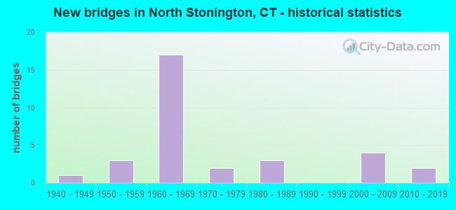
- New bridges - historical statistics
- 11940-1949
- 31950-1959
- 171960-1969
- 21970-1979
- 31980-1989
- 42000-2009
- 22010-2019

- Reconstructed bridges - Historical Statistics
- 21980-1989
- 01990-1999
- 12000-2009


- Bridge Condition - Deck
- 25.0%Very good
- 31.3%Good
- 31.3%Satisfactory
- 12.5%Fair

- Bridge Condition - Superstructure
- 22.2%Very good
- 27.8%Good
- 16.7%Satisfactory
- 33.3%Fair

- Bridge Condition - Substructure
- 22.2%Very good
- 38.9%Good
- 38.9%Satisfactory

- Bridge Condition - Channel
- 23.1%Very good
- 15.4%Good
- 38.5%Satisfactory
- 23.1%Fair
Find on map >> Show street view
Structure Number: 181, Location: 0.3 MI S OF ROUTE 100 (Lat: 41.284839, Lng: -72.874461), Route carried "on" structure: Interstate 95, Year Built: 1958, Year Reconstructed: 2006, Status: Open, Structure Length: 8.75m (28.71ft), Average Daily Traffic: 93,700 (year 2017), Truck Traffic: 14%, Average Future Daily Traffic: 139,229 (year 2037), Design Load: HS 20, Features Intersected: US RT. 1 SB AND AMTRAK
Minimum Vertical Clearance: 30+ m (98+ ft), Kilometerpoint: 80.870, Lanes on structure: 8, Lanes under structure: 2, Base Highway Network: Yes, Owner: State Highway Agency, Approaching Roadway Width: 42.1m (138.1ft), Skew: 35 degrees, Material/Design: Steel continuous, Design/Construction: Stringer/Multi-beam, Number Of Spans In Main Unit: 3, Length of Maximum Span: 34.4m (112.9ft), Curb-To-Curb Width: 42.0m (137.8ft), Out-to-Out Width: 44.9m (147.3ft)
Condition: Deck: Good, Superstructure: Good, Substructure: Good, Operating Rating: 39.9 metric tons, Method Used To Determine Operating Rating: Load and Resistance Factor Rating (LRFR) rating reported by rating factor(RF) method using HL-93 loadings, Inventory Rating: 30.8 metric tons, Method Used To Determine Inventory Rating: Load and Resistance Factor Rating (LRFR) rating reported by rating factor(RF) method using HL-93 loadings, Structural Evaluation: Better than present minimum criteria, Deck Geometry: Superior to present desirable criteria, Underclear: High priority of corrective action, Approach Roadway Alignment: Equal to present desirable criteria, Designated Inspection Frequency: Every 24 months, Inspection Date: March 2020, Deck Structure Type: Concrete Cast-file-Place, Wearing Surface/Protective System: Wearing Surface: Bituminous, Membrane: Built-up, Deck Protection: Epoxy Coated Reinforcing
Find on map >> Show street view
Structure Number: 416, Location: 0.1 E OF ROUTE 201 (Lat: 41.461850, Lng: -71.908708), Route carried "on" structure: State highway 2, Year Built: 1959, Status: Open, Structure Length: 1.07m (3.51ft), Average Daily Traffic: 13,400 (year 2017), Truck Traffic: 6%, Average Future Daily Traffic: 19,911 (year 2037), Design Load: HS 20, Features Intersected: SHUNOCK RIVER
Minimum Vertical Clearance: 30+ m (98+ ft), Kilometerpoint: 81.224, Lanes on structure: 2, Base Highway Network: Yes, Owner: State Highway Agency, Approaching Roadway Width: 10.4m (34.1ft), Skew: 3 degrees, Material/Design: Prestressed concrete, Design/Construction: Slab, Number Of Spans In Main Unit: 1, Length of Maximum Span: 9.4m (30.8ft), Curb-To-Curb Width: 10.5m (34.4ft), Out-to-Out Width: 12.2m (40.0ft)
Condition: Deck: Fair, Superstructure: Fair, Substructure: Good, Channel: Satisfactory, Operating Rating: 43.1 metric tons, Method Used To Determine Operating Rating: Load and Resistance Factor Rating (LRFR) rating reported by rating factor(RF) method using HL-93 loadings, Inventory Rating: 33.4 metric tons, Method Used To Determine Inventory Rating: Load and Resistance Factor Rating (LRFR) rating reported by rating factor(RF) method using HL-93 loadings, Structural Evaluation: Somewhat better than minimum adequacy, Deck Geometry: Meets minimum limits, Waterway Adequacy: Equal to present minimum criteria, Approach Roadway Alignment: Equal to present desirable criteria, Designated Inspection Frequency: Every 24 months, Inspection Date: July 2020, Deck Structure Type: Other, Wearing Surface/Protective System: Wearing Surface: Bituminous, Membrane: Preformed Fabric
Find on map >> Show street view
Structure Number: 1011, Location: 0.6 MI N OF ROUTE 2 (Lat: 41.410186, Lng: -71.844828), Route carried "on" structure: State highway 49, Year Built: 1954, Status: Open, Structure Length: 0.82m (2.69ft), Average Daily Traffic: 5,400 (year 2017), Truck Traffic: 3%, Average Future Daily Traffic: 8,024 (year 2037), Design Load: H 20, Features Intersected: SHUNOCK RIVER
Minimum Vertical Clearance: 30+ m (98+ ft), Kilometerpoint: 0.901, Lanes on structure: 2, Owner: State Highway Agency, Approaching Roadway Width: 9.8m (32.2ft), Material/Design: Concrete, Design/Construction: Slab, Number Of Spans In Main Unit: 1, Length of Maximum Span: 7.3m (24.0ft), Curb-To-Curb Width: 9.8m (32.2ft), Out-to-Out Width: 11.5m (37.7ft)
Condition: Deck: Good, Superstructure: Good, Substructure: Satisfactory, Channel: Satisfactory, Operating Rating: 49.0 metric tons, Method Used To Determine Operating Rating: Load Factor (LF), Inventory Rating: 29.0 metric tons, Method Used To Determine Inventory Rating: Load Factor (LF), Structural Evaluation: Equal to present minimum criteria, Deck Geometry: Meets minimum limits, Waterway Adequacy: Equal to present minimum criteria, Approach Roadway Alignment: Better than present minimum criteria, Designated Inspection Frequency: Every 24 months, Underwater Inspection Frequency: Every 24 months, Inspection Date: September 2020, Underwater Inspection Date: September 2020, Deck Structure Type: Concrete Cast-file-Place, Wearing Surface/Protective System: Wearing Surface: Bituminous, Membrane: Preformed Fabric
Find on map >> Show street view
Structure Number: 1555, Location: 1.3 MI W OF I-95 (Lat: 41.454797, Lng: -71.813650), Route carried "on" structure: State highway 216, Year Built: 1949, Status: Open, Structure Length: 0.82m (2.69ft), Average Daily Traffic: 1,500 (year 2017), Truck Traffic: 2%, Average Future Daily Traffic: 2,229 (year 2037), Design Load: HS 20, Features Intersected: GREEN FALLS RIVER
Minimum Vertical Clearance: 30+ m (98+ ft), Kilometerpoint: 2.060, Lanes on structure: 2, Owner: State Highway Agency, Approaching Roadway Width: 8.5m (27.9ft), Skew: 2 degrees, Material/Design: Concrete continuous, Design/Construction: Culvert, Number Of Spans In Main Unit: 2, Length of Maximum Span: 4.0m (13.1ft)
Condition: Channel: Satisfactory, Culverts: Good, Operating Rating: 40.2 metric tons, Method Used To Determine Operating Rating: Load and Resistance Factor Rating (LRFR) rating reported by rating factor(RF) method using HL-93 loadings, Inventory Rating: 31.1 metric tons, Method Used To Determine Inventory Rating: Load and Resistance Factor Rating (LRFR) rating reported by rating factor(RF) method using HL-93 loadings, Structural Evaluation: Better than present minimum criteria, Waterway Adequacy: Better than present minimum criteria, Approach Roadway Alignment: Equal to present desirable criteria, Designated Inspection Frequency: Every 48 months, Underwater Inspection Frequency: Every 48 months, Inspection Date: August 2021, Underwater Inspection Date: August 2021
Find on map >> Show street view
Structure Number: 1808, Location: 1 MILE WEST OF ROUTE 49 (Lat: 41.411528, Lng: -71.855525), Route carried "on" structure: Interstate 95, Year Built: 1964, Year Reconstructed: 1989, Status: Open, Structure Length: 4.60m (15.09ft), Average Daily Traffic: 13,400 (year 2020), Truck Traffic: 14%, Average Future Daily Traffic: 19,911 (year 2040), Design Load: HS 20, Features Intersected: ROUTE 2
Minimum Vertical Clearance: 30+ m (98+ ft), Kilometerpoint: 173.439, Lanes on structure: 2, Lanes under structure: 3, Base Highway Network: Yes, Owner: State Highway Agency, Approaching Roadway Width: 11.6m (38.1ft), Skew: 4 degrees, Material/Design: Steel, Design/Construction: Stringer/Multi-beam, Number Of Spans In Main Unit: 3, Length of Maximum Span: 21.3m (69.9ft), Curb or Sidewalk Widths: Left: 0.5m (1.6ft), Right: 0.5m (1.6ft), Curb-To-Curb Width: 11.6m (38.1ft), Out-to-Out Width: 13.3m (43.6ft)
Condition: Deck: Satisfactory, Superstructure: Fair, Substructure: Satisfactory, Operating Rating: 31.8 metric tons, Method Used To Determine Operating Rating: Load and Resistance Factor Rating (LRFR) rating reported by rating factor(RF) method using HL-93 loadings, Inventory Rating: 24.3 metric tons, Method Used To Determine Inventory Rating: Load and Resistance Factor Rating (LRFR) rating reported by rating factor(RF) method using HL-93 loadings, Structural Evaluation: Somewhat better than minimum adequacy, Deck Geometry: Equal to present minimum criteria, Underclear: Meets minimum limits, Approach Roadway Alignment: Equal to present desirable criteria, Designated Inspection Frequency: Every 24 months, Inspection Date: November 2021, Deck Structure Type: Concrete Cast-file-Place, Wearing Surface/Protective System: Wearing Surface: Bituminous, Membrane: Preformed Fabric
Find on map >> Show street view
Structure Number: 1809, Location: .8 MI SOUTH OF ROUTE 49 (Lat: 41.411928, Lng: -71.855664), Route carried "on" structure: Interstate 95, Year Built: 1964, Year Reconstructed: 1989, Status: Open, Structure Length: 4.59m (15.06ft), Average Daily Traffic: 13,400 (year 2020), Truck Traffic: 14%, Average Future Daily Traffic: 19,911 (year 2040), Design Load: HS 20, Features Intersected: ROUTE 2
Minimum Vertical Clearance: 30+ m (98+ ft), Kilometerpoint: 173.471, Lanes on structure: 2, Lanes under structure: 3, Base Highway Network: Yes, Owner: State Highway Agency, Approaching Roadway Width: 12.8m (42.0ft), Skew: 4 degrees, Material/Design: Steel, Design/Construction: Stringer/Multi-beam, Number Of Spans In Main Unit: 3, Length of Maximum Span: 21.3m (69.9ft), Curb or Sidewalk Widths: Left: 0.5m (1.6ft), Right: 0.5m (1.6ft), Curb-To-Curb Width: 12.8m (42.0ft), Out-to-Out Width: 14.5m (47.6ft)
Condition: Deck: Satisfactory, Superstructure: Fair, Substructure: Satisfactory, Operating Rating: 47.0 metric tons, Method Used To Determine Operating Rating: Load and Resistance Factor Rating (LRFR) rating reported by rating factor(RF) method using HL-93 loadings, Inventory Rating: 36.3 metric tons, Method Used To Determine Inventory Rating: Load and Resistance Factor Rating (LRFR) rating reported by rating factor(RF) method using HL-93 loadings, Structural Evaluation: Somewhat better than minimum adequacy, Deck Geometry: Equal to present desirable criteria, Underclear: Meets minimum limits, Approach Roadway Alignment: Equal to present desirable criteria, Designated Inspection Frequency: Every 24 months, Inspection Date: November 2021, Deck Structure Type: Concrete Cast-file-Place, Wearing Surface/Protective System: Wearing Surface: Bituminous, Membrane: Preformed Fabric
Find on map >> Show street view
Structure Number: 181, Location: 0.3 MI S OF ROUTE 49 (Lat: 41.417011, Lng: -71.849136), Route carried "on" structure: Interstate 95, Year Built: 1964, Status: Open, Structure Length: 1.09m (3.58ft), Average Daily Traffic: 14,500 (year 2017), Truck Traffic: 10%, Average Future Daily Traffic: 21,546 (year 2037), Design Load: H 20, Features Intersected: SHUNOCK RIVER
Minimum Vertical Clearance: 30+ m (98+ ft), Kilometerpoint: 174.260, Lanes on structure: 2, Base Highway Network: Yes, Owner: State Highway Agency, Approaching Roadway Width: 12.2m (40.0ft), Skew: 22 degrees, Material/Design: Concrete continuous, Design/Construction: Culvert, Number Of Spans In Main Unit: 2, Length of Maximum Span: 4.9m (16.1ft)
Condition: Channel: Fair, Culverts: Good, Structural Evaluation: Better than present minimum criteria, Waterway Adequacy: Better than present minimum criteria, Approach Roadway Alignment: Equal to present desirable criteria, Designated Inspection Frequency: Every 24 months, Inspection Date: August 2021
Find on map >> Show street view
Structure Number: 1811, Location: 0.3 MI S OF ROUTE 49 (Lat: 41.417647, Lng: -71.849525), Route carried "on" structure: Interstate 95, Year Built: 1970, Status: Open, Structure Length: 1.13m (3.71ft), Average Daily Traffic: 13,900 (year 2017), Truck Traffic: 10%, Average Future Daily Traffic: 20,654 (year 2037), Design Load: H 20, Features Intersected: SHUNOCK RIVER
Minimum Vertical Clearance: 30+ m (98+ ft), Kilometerpoint: 174.292, Lanes on structure: 3, Base Highway Network: Yes, Owner: State Highway Agency, Approaching Roadway Width: 19.5m (64.0ft), Skew: 22 degrees, Material/Design: Concrete continuous, Design/Construction: Culvert, Number Of Spans In Main Unit: 2, Length of Maximum Span: 5.5m (18.0ft)
Condition: Channel: Fair, Culverts: Good, Structural Evaluation: Better than present minimum criteria, Waterway Adequacy: Better than present minimum criteria, Approach Roadway Alignment: Equal to present desirable criteria, Designated Inspection Frequency: Every 24 months, Inspection Date: August 2021
Find on map >> Show street view
Structure Number: 1812, Location: I-95 EXIT NO. 92 (Lat: 41.419681, Lng: -71.844597), Route carried "on" structure: Interstate 95, Year Built: 1964, Status: Open, Structure Length: 4.01m (13.16ft), Average Daily Traffic: 13,400 (year 2020), Truck Traffic: 9%, Average Future Daily Traffic: 19,911 (year 2040), Design Load: HS 20, Features Intersected: ROUTE 49
Minimum Vertical Clearance: 30+ m (98+ ft), Kilometerpoint: 174.743, Lanes on structure: 2, Lanes under structure: 2, Base Highway Network: Yes, Owner: State Highway Agency, Approaching Roadway Width: 12.8m (42.0ft), Skew: 3 degrees, Material/Design: Steel, Design/Construction: Stringer/Multi-beam, Number Of Spans In Main Unit: 3, Length of Maximum Span: 19.4m (63.6ft), Curb or Sidewalk Widths: Left: 0.5m (1.6ft), Right: 0.5m (1.6ft), Curb-To-Curb Width: 12.8m (42.0ft), Out-to-Out Width: 14.5m (47.6ft)
Condition: Deck: Good, Superstructure: Fair, Substructure: Good, Operating Rating: 44.7 metric tons, Method Used To Determine Operating Rating: Load and Resistance Factor Rating (LRFR) rating reported by rating factor(RF) method using HL-93 loadings, Inventory Rating: 34.7 metric tons, Method Used To Determine Inventory Rating: Load and Resistance Factor Rating (LRFR) rating reported by rating factor(RF) method using HL-93 loadings, Structural Evaluation: Somewhat better than minimum adequacy, Deck Geometry: Equal to present desirable criteria, Underclear: Somewhat better than minimum adequacy, Approach Roadway Alignment: Equal to present desirable criteria, Designated Inspection Frequency: Every 24 months, Inspection Date: December 2021, Total Project Cost: $2,400,000 ( Estimate for 2017), Deck Structure Type: Concrete Cast-file-Place, Wearing Surface/Protective System: Wearing Surface: Bituminous, Membrane: Preformed Fabric
Find on map >> Show street view
Structure Number: 1813, Location: I-95 EXIT NO. 92 (Lat: 41.420453, Lng: -71.844636), Route carried "on" structure: Interstate 95, Year Built: 1964, Status: Open, Structure Length: 4.11m (13.48ft), Average Daily Traffic: 13,400 (year 2020), Truck Traffic: 9%, Average Future Daily Traffic: 19,911 (year 2040), Design Load: HS 20, Features Intersected: ROUTE 49
Minimum Vertical Clearance: 30+ m (98+ ft), Kilometerpoint: 174.791, Lanes on structure: 2, Lanes under structure: 2, Base Highway Network: Yes, Owner: State Highway Agency, Approaching Roadway Width: 11.6m (38.1ft), Skew: 13 degrees, Material/Design: Steel, Design/Construction: Stringer/Multi-beam, Number Of Spans In Main Unit: 3, Length of Maximum Span: 19.4m (63.6ft), Curb or Sidewalk Widths: Left: 0.5m (1.6ft), Right: 0.5m (1.6ft), Curb-To-Curb Width: 11.6m (38.1ft), Out-to-Out Width: 13.3m (43.6ft)
Condition: Deck: Satisfactory, Superstructure: Fair, Substructure: Good, Operating Rating: 56.4 metric tons, Method Used To Determine Operating Rating: Load and Resistance Factor Rating (LRFR) rating reported by rating factor(RF) method using HL-93 loadings, Inventory Rating: 43.4 metric tons, Method Used To Determine Inventory Rating: Load and Resistance Factor Rating (LRFR) rating reported by rating factor(RF) method using HL-93 loadings, Structural Evaluation: Somewhat better than minimum adequacy, Deck Geometry: Equal to present minimum criteria, Underclear: Equal to present minimum criteria, Approach Roadway Alignment: Equal to present desirable criteria, Designated Inspection Frequency: Every 24 months, Inspection Date: December 2021, Total Project Cost: $2,400,000 ( Estimate for 2017), Deck Structure Type: Concrete Cast-file-Place, Wearing Surface/Protective System: Wearing Surface: Bituminous, Membrane: Preformed Fabric
Find on map >> Show street view
Structure Number: 1814, Location: 1.7 MI N OF ROUTE 49 (Lat: 41.430928, Lng: -71.813972), Route carried "on" structure: City street , Year Built: 1964, Status: Open, Structure Length: 14.45m (47.41ft), Average Daily Traffic: 173 (year 2020), Truck Traffic: 5%, Average Future Daily Traffic: 257 (year 2040), Design Load: H 20, Features Intersected: INTERSTATE-95, Facility Carried by Structure: BOOM BRIDGE ROAD
Minimum Vertical Clearance: 30+ m (98+ ft), Kilometerpoint: 1.706, Lanes on structure: 2, Lanes under structure: 4, Owner: State Highway Agency, Approaching Roadway Width: 9.1m (29.9ft), Skew: 4 degrees, Material/Design: Steel, Design/Construction: Stringer/Multi-beam, Number Of Spans In Main Unit: 6, Length of Maximum Span: 25.7m (84.3ft), Curb or Sidewalk Widths: Left: 0.5m (1.6ft), Right: 0.5m (1.6ft), Curb-To-Curb Width: 9.1m (29.9ft), Out-to-Out Width: 10.8m (35.4ft)
Condition: Deck: Fair, Superstructure: Fair, Substructure: Satisfactory, Operating Rating: 84.9 metric tons, Method Used To Determine Operating Rating: Load Factor (LF), Inventory Rating: 50.9 metric tons, Method Used To Determine Inventory Rating: Load Factor (LF), Structural Evaluation: Somewhat better than minimum adequacy, Deck Geometry: Equal to present minimum criteria, Underclear: Somewhat better than minimum adequacy, Approach Roadway Alignment: Equal to present minimum criteria, Designated Inspection Frequency: Every 24 months, Inspection Date: May 2020, Deck Structure Type: Concrete Cast-file-Place, Wearing Surface/Protective System: Wearing Surface: Bituminous, Membrane: Built-up
Find on map >> Show street view
Structure Number: 1815, Location: 2.7 MI N OF ROUTE 49 (Lat: 41.440119, Lng: -71.799525), Route carried "on" structure: Interstate 95, Year Built: 1964, Status: Open, Structure Length: 3.60m (11.81ft), Average Daily Traffic: 17,900 (year 2017), Truck Traffic: 6%, Average Future Daily Traffic: 26,598 (year 2037), Design Load: HS 20, Features Intersected: ROUTE 216
Minimum Vertical Clearance: 30+ m (98+ ft), Kilometerpoint: 179.184, Lanes on structure: 2, Lanes under structure: 2, Base Highway Network: Yes, Owner: State Highway Agency, Approaching Roadway Width: 11.6m (38.1ft), Skew: 1 degrees, Material/Design: Steel, Design/Construction: Stringer/Multi-beam, Number Of Spans In Main Unit: 3, Length of Maximum Span: 16.5m (54.1ft), Curb or Sidewalk Widths: Left: 0.5m (1.6ft), Right: 0.5m (1.6ft), Curb-To-Curb Width: 11.6m (38.1ft), Out-to-Out Width: 13.3m (43.6ft)
Condition: Deck: Satisfactory, Superstructure: Satisfactory, Substructure: Satisfactory, Operating Rating: 43.7 metric tons, Method Used To Determine Operating Rating: Load and Resistance Factor Rating (LRFR) rating reported by rating factor(RF) method using HL-93 loadings, Inventory Rating: 33.7 metric tons, Method Used To Determine Inventory Rating: Load and Resistance Factor Rating (LRFR) rating reported by rating factor(RF) method using HL-93 loadings, Structural Evaluation: Equal to present minimum criteria, Deck Geometry: Better than present minimum criteria, Underclear: Meets minimum limits, Approach Roadway Alignment: Equal to present desirable criteria, Designated Inspection Frequency: Every 24 months, Inspection Date: July 2021, Deck Structure Type: Concrete Cast-file-Place, Wearing Surface/Protective System: Wearing Surface: Bituminous, Membrane: Preformed Fabric
Find on map >> Show street view
Structure Number: 1816, Location: 2.7 MI N OF ROUTE 49 (Lat: 41.440506, Lng: -71.799897), Route carried "on" structure: Interstate 95, Year Built: 1964, Status: Open, Structure Length: 3.58m (11.75ft), Average Daily Traffic: 14,500 (year 2017), Truck Traffic: 9%, Average Future Daily Traffic: 21,546 (year 2037), Design Load: HS 20, Features Intersected: ROUTE 216
Minimum Vertical Clearance: 30+ m (98+ ft), Kilometerpoint: 179.200, Lanes on structure: 2, Lanes under structure: 2, Base Highway Network: Yes, Owner: State Highway Agency, Approaching Roadway Width: 12.8m (42.0ft), Material/Design: Steel, Design/Construction: Stringer/Multi-beam, Number Of Spans In Main Unit: 3, Length of Maximum Span: 16.1m (52.8ft), Curb or Sidewalk Widths: Left: 0.5m (1.6ft), Right: 0.5m (1.6ft), Curb-To-Curb Width: 12.8m (42.0ft), Out-to-Out Width: 14.5m (47.6ft)
Condition: Deck: Satisfactory, Superstructure: Satisfactory, Substructure: Satisfactory, Operating Rating: 42.1 metric tons, Method Used To Determine Operating Rating: Load and Resistance Factor Rating (LRFR) rating reported by rating factor(RF) method using HL-93 loadings, Inventory Rating: 32.4 metric tons, Method Used To Determine Inventory Rating: Load and Resistance Factor Rating (LRFR) rating reported by rating factor(RF) method using HL-93 loadings, Structural Evaluation: Equal to present minimum criteria, Deck Geometry: Equal to present desirable criteria, Underclear: Somewhat better than minimum adequacy, Approach Roadway Alignment: Better than present minimum criteria, Designated Inspection Frequency: Every 24 months, Inspection Date: July 2021, Deck Structure Type: Concrete Cast-file-Place, Wearing Surface/Protective System: Wearing Surface: Bituminous, Membrane: Preformed Fabric
Find on map >> Show street view
Structure Number: 2781, Location: 0.6 MI E OF ROUTE 2 (Lat: 41.430458, Lng: -71.851836), Route carried "on" structure: State highway 184, Year Built: 2014, Status: Open, Structure Length: 2.10m (6.89ft), Average Daily Traffic: 6,100 (year 2015), Truck Traffic: 3%, Average Future Daily Traffic: 9,064 (year 2035), Design Load: HL 93, Features Intersected: SHUNOCK RIVER
Minimum Vertical Clearance: 30+ m (98+ ft), Kilometerpoint: 20.680, Lanes on structure: 2, Owner: State Highway Agency, Approaching Roadway Width: 9.8m (32.2ft), Skew: 3 degrees, Material/Design: Steel, Design/Construction: Stringer/Multi-beam, Number Of Spans In Main Unit: 1, Length of Maximum Span: 19.8m (65.0ft), Curb-To-Curb Width: 9.8m (32.2ft), Out-to-Out Width: 10.9m (35.8ft)
Condition: Deck: Very good, Superstructure: Very good, Substructure: Very good, Channel: Very good, Operating Rating: 50.9 metric tons, Method Used To Determine Operating Rating: Load and Resistance Factor Rating (LRFR) rating reported by rating factor(RF) method using HL-93 loadings, Inventory Rating: 39.2 metric tons, Method Used To Determine Inventory Rating: Load and Resistance Factor Rating (LRFR) rating reported by rating factor(RF) method using HL-93 loadings, Structural Evaluation: Equal to present desirable criteria, Deck Geometry: Meets minimum limits, Waterway Adequacy: Better than present minimum criteria, Approach Roadway Alignment: Equal to present desirable criteria, Designated Inspection Frequency: Every 48 months, Inspection Date: May 2019, Deck Structure Type: Concrete Cast-file-Place, Wearing Surface/Protective System: Wearing Surface: Bituminous, Membrane: Other, Deck Protection: Epoxy Coated Reinforcing
Find on map >> Show street view
Structure Number: 3144, Location: 1.0 MI E OF ROUTE 49 (Lat: 41.456164, Lng: -71.816586), Route carried "on" structure: State highway 216, Year Built: 1965, Status: Open, Structure Length: 2.07m (6.79ft), Average Daily Traffic: 800 (year 2017), Truck Traffic: 2%, Average Future Daily Traffic: 1,189 (year 2037), Design Load: HS 20, Features Intersected: GREEN FALLS RIVER
Minimum Vertical Clearance: 30+ m (98+ ft), Kilometerpoint: 1.706, Lanes on structure: 2, Owner: State Highway Agency, Approaching Roadway Width: 9.1m (29.9ft), Skew: 2 degrees, Material/Design: Prestressed concrete, Design/Construction: Box Beam or Girders - Multiple, Number Of Spans In Main Unit: 1, Length of Maximum Span: 18.9m (62.0ft), Curb or Sidewalk Widths: Left: 0.5m (1.6ft), Right: 0.5m (1.6ft), Curb-To-Curb Width: 9.1m (29.9ft), Out-to-Out Width: 10.2m (33.5ft)
Condition: Deck: Good, Superstructure: Satisfactory, Substructure: Good, Channel: Good, Operating Rating: 66.5 metric tons, Method Used To Determine Operating Rating: Load Factor (LF), Inventory Rating: 39.8 metric tons, Method Used To Determine Inventory Rating: Load Factor (LF), Structural Evaluation: Equal to present minimum criteria, Deck Geometry: Equal to present minimum criteria, Waterway Adequacy: Better than present minimum criteria, Approach Roadway Alignment: Equal to present desirable criteria, Designated Inspection Frequency: Every 24 months, Inspection Date: March 2021, Deck Structure Type: Other, Wearing Surface/Protective System: Wearing Surface: Bituminous, Membrane: Built-up
Find on map >> Show street view
Structure Number: 362, Location: 0.4 MI E OF ROUTE 2 (Lat: 41.417394, Lng: -71.853008), Route carried "on" structure: Alternate State highway 617, Year Built: 1970, Status: Open, Structure Length: 1.04m (3.41ft), Average Daily Traffic: 3,600 (year 2017), Truck Traffic: 3%, Average Future Daily Traffic: 5,349 (year 2037), Design Load: HS 20, Features Intersected: SHUNOCK RIVER
Minimum Vertical Clearance: 30+ m (98+ ft), Kilometerpoint: 0.563, Lanes on structure: 2, Owner: State Highway Agency, Approaching Roadway Width: 13.4m (44.0ft), Skew: 1 degrees, Material/Design: Concrete continuous, Design/Construction: Culvert, Number Of Spans In Main Unit: 2, Length of Maximum Span: 4.9m (16.1ft)
Condition: Channel: Fair, Culverts: Good, Operating Rating: 78.7 metric tons, Method Used To Determine Operating Rating: Load and Resistance Factor Rating (LRFR) rating reported by rating factor(RF) method using HL-93 loadings, Inventory Rating: 60.6 metric tons, Method Used To Determine Inventory Rating: Load and Resistance Factor Rating (LRFR) rating reported by rating factor(RF) method using HL-93 loadings, Structural Evaluation: Better than present minimum criteria, Waterway Adequacy: Better than present minimum criteria, Approach Roadway Alignment: Equal to present desirable criteria, Designated Inspection Frequency: Every 24 months, Inspection Date: August 2021
Find on map >> Show street view
Structure Number: 4744, Location: .75 MI SW OF ANTHONY RD (Lat: 41.417489, Lng: -71.823439), Route carried "on" structure: City street , Year Built: 1968, Year Reconstructed: 2021, Status: Open, Structure Length: 3.83m (12.57ft), Average Daily Traffic: 100 (year 2021), Average Future Daily Traffic: 149 (year 2041), Features Intersected: PAWCATUCK RIVER, Facility Carried by Structure: BOOM BRIDGE ROAD
Minimum Vertical Clearance: 30+ m (98+ ft), Kilometerpoint: 0.032, Lanes on structure: 2, Owner: Town or Township Highway Agency, Approaching Roadway Width: 7.2m (23.6ft), Material/Design: Steel, Design/Construction: Stringer/Multi-beam, Number Of Spans In Main Unit: 1, Length of Maximum Span: 37.2m (122.0ft), Curb-To-Curb Width: 7.3m (24.0ft), Out-to-Out Width: 8.4m (27.6ft)
Condition: Deck: Very good, Superstructure: Very good, Substructure: Very good, Channel: Very good, Operating Rating: 58.0 metric tons, Method Used To Determine Operating Rating: Load and Resistance Factor Rating (LRFR) rating reported by rating factor(RF) method using HL-93 loadings, Inventory Rating: 44.7 metric tons, Method Used To Determine Inventory Rating: Load and Resistance Factor Rating (LRFR) rating reported by rating factor(RF) method using HL-93 loadings, Structural Evaluation: Equal to present desirable criteria, Deck Geometry: Equal to present minimum criteria, Waterway Adequacy: Superior to present desirable criteria, Approach Roadway Alignment: Equal to present desirable criteria, Designated Inspection Frequency: Every 24 months, Inspection Date: October 2021, Total Project Cost: $3,195,000, Deck Structure Type: Concrete Cast-file-Place, Wearing Surface/Protective System: Wearing Surface: Bituminous, Membrane: Other, Deck Protection: Epoxy Coated Reinforcing
Find on map >> Show street view
Structure Number: 5457, Location: 0.6 MI EAST OF ROUTE 49 (Lat: 41.454667, Lng: -71.826117), Route carried "on" structure: State highway 216, Year Built: 2009, Status: Open, Structure Length: 0.98m (3.22ft), Average Daily Traffic: 750 (year 2017), Truck Traffic: 3%, Average Future Daily Traffic: 1,114 (year 2037), Design Load: HS 20, Features Intersected: SPAULDING BROOK
Minimum Vertical Clearance: 30+ m (98+ ft), Kilometerpoint: 0.901, Lanes on structure: 2, Owner: State Highway Agency, Approaching Roadway Width: 8.5m (27.9ft), Skew: 2 degrees, Material/Design: Concrete, Design/Construction: Frame, Number Of Spans In Main Unit: 1, Length of Maximum Span: 9.8m (32.2ft), Curb-To-Curb Width: 8.5m (27.9ft), Out-to-Out Width: 9.8m (32.2ft)
Condition: Superstructure: Good, Substructure: Satisfactory, Channel: Satisfactory, Operating Rating: 73.8 metric tons, Method Used To Determine Operating Rating: Load Factor (LF), Inventory Rating: 44.4 metric tons, Method Used To Determine Inventory Rating: Load Factor (LF), Structural Evaluation: Equal to present minimum criteria, Deck Geometry: Somewhat better than minimum adequacy, Waterway Adequacy: Superior to present desirable criteria, Approach Roadway Alignment: Equal to present minimum criteria, Designated Inspection Frequency: Every 24 months, Inspection Date: May 2021
Find on map >> Show street view
Structure Number: 5504, Location: Rte 22 to Mill Road (Lat: 41.380458, Lng: -72.827086), Route carried "on" structure: City street , Year Built: 1987, Status: Open, Structure Length: 1.43m (4.69ft), Average Daily Traffic: 824 (year 2019), Truck Traffic: 2%, Average Future Daily Traffic: 1,224 (year 2039), Features Intersected: MUDDY RIVER, Facility Carried by Structure: PATTEN ROAD
Minimum Vertical Clearance: 30+ m (98+ ft), Kilometerpoint: 0.016, Lanes on structure: 2, Owner: Town or Township Highway Agency, Approaching Roadway Width: 9.1m (29.9ft), Skew: 1 degrees, Material/Design: Concrete, Design/Construction: Culvert, Number Of Spans In Main Unit: 3, Length of Maximum Span: 4.3m (14.1ft), Curb-To-Curb Width: 9.3m (30.5ft), Out-to-Out Width: 10.7m (35.1ft)
Condition: Channel: Satisfactory, Culverts: Good, Operating Rating: 42.6 metric tons, Method Used To Determine Operating Rating: Field evaluation and documented engineering judgment, Inventory Rating: 32.7 metric tons, Method Used To Determine Inventory Rating: Field evaluation and documented engineering judgment, Structural Evaluation: Better than present minimum criteria, Deck Geometry: Equal to present minimum criteria, Waterway Adequacy: Better than present minimum criteria, Approach Roadway Alignment: Meets minimum limits, Designated Inspection Frequency: Every 24 months, Inspection Date: Febuary 2021, Wearing Surface/Protective System: Wearing Surface: Bituminous, Membrane: Built-up
Find on map >> Show street view
Structure Number: 5723, Location: 0.2 MI E OF US ROUTE 5 (Lat: 41.389189, Lng: -72.867378), Route carried "on" structure: State highway 729, Year Built: 1988, Status: Open, Structure Length: 6.49m (21.29ft), Average Daily Traffic: 8,100 (year 2018), Truck Traffic: 5%, Average Future Daily Traffic: 12,036 (year 2038), Design Load: HS 20, Features Intersected: AMTRAK RAILROAD
Minimum Vertical Clearance: 30+ m (98+ ft), Kilometerpoint: 0.386, Lanes on structure: 2, Owner: State Highway Agency, Approaching Roadway Width: 13.4m (44.0ft), Skew: 3 degrees, Material/Design: Steel continuous, Design/Construction: Stringer/Multi-beam, Number Of Spans In Main Unit: 3, Length of Maximum Span: 23.2m (76.1ft), Curb or Sidewalk Widths: Left: 0.0m, Right: 1.7m (5.6ft), Curb-To-Curb Width: 13.4m (44.0ft), Out-to-Out Width: 16.1m (52.8ft)
Condition: Deck: Good, Superstructure: Good, Substructure: Good, Operating Rating: 26.6 metric tons, Method Used To Determine Operating Rating: Load and Resistance Factor Rating (LRFR) rating reported by rating factor(RF) method using HL-93 loadings, Inventory Rating: 20.4 metric tons, Method Used To Determine Inventory Rating: Load and Resistance Factor Rating (LRFR) rating reported by rating factor(RF) method using HL-93 loadings, Structural Evaluation: Somewhat better than minimum adequacy, Deck Geometry: Equal to present minimum criteria, Underclear: High priority of corrective action, Approach Roadway Alignment: Equal to present desirable criteria, Designated Inspection Frequency: Every 24 months, Inspection Date: September 2019, Deck Structure Type: Concrete Cast-file-Place, Wearing Surface/Protective System: Wearing Surface: Bituminous, Membrane: Built-up, Deck Protection: Epoxy Coated Reinforcing
Find on map >> Show street view
Structure Number: 5724, Location: .1 MI SOUTH OF JCT US 44 (Lat: 42.022622, Lng: -73.324781), Route carried "on" structure: US 7, Year Built: 1989, Status: Open, Structure Length: 0.61m (2.00ft), Average Daily Traffic: 6,411 (year 2018), Truck Traffic: 6%, Average Future Daily Traffic: 9,526 (year 2038), Design Load: HS 20, Features Intersected: EDDYS COVE
Minimum Vertical Clearance: 30+ m (98+ ft), Kilometerpoint: 122.745, Lanes on structure: 2, Base Highway Network: Yes, Owner: State Highway Agency, Approaching Roadway Width: 10.4m (34.1ft), Material/Design: Concrete, Design/Construction: Culvert, Number Of Spans In Main Unit: 1, Length of Maximum Span: 6.1m (20.0ft), Curb or Sidewalk Widths: Left: 1.7m (5.6ft), Right: 0.0m, Curb-To-Curb Width: 10.4m (34.1ft), Out-to-Out Width: 13.0m (42.7ft)
Condition: Channel: Good, Culverts: Good, Operating Rating: 62.5 metric tons, Method Used To Determine Operating Rating: Load and Resistance Factor Rating (LRFR) rating reported by rating factor(RF) method using HL-93 loadings, Inventory Rating: 48.3 metric tons, Method Used To Determine Inventory Rating: Load and Resistance Factor Rating (LRFR) rating reported by rating factor(RF) method using HL-93 loadings, Structural Evaluation: Better than present minimum criteria, Deck Geometry: Meets minimum limits, Waterway Adequacy: Equal to present desirable criteria, Approach Roadway Alignment: Equal to present desirable criteria, Designated Inspection Frequency: Every 48 months, Inspection Date: July 2018, Wearing Surface/Protective System: Wearing Surface: Bituminous, Membrane: Built-up
Find on map >> Show street view
Structure Number: 6765, Location: 2.4 MI E OF ROUTE 164 (Lat: 41.470314, Lng: -71.950822), Route carried "on" structure: State highway 2, Year Built: 2009, Status: Open, Structure Length: 5.15m (16.90ft), Average Daily Traffic: 9,300 (year 2017), Truck Traffic: 6%, Average Future Daily Traffic: 13,819 (year 2037), Design Load: HL 93, Features Intersected: ROUTE 2 RAMPS
Minimum Vertical Clearance: 30+ m (98+ ft), Kilometerpoint: 77.361, Lanes on structure: 5, Lanes under structure: 4, Base Highway Network: Yes, Owner: State Highway Agency, Approaching Roadway Width: 23.8m (78.1ft), Skew: 1 degrees, Material/Design: Steel, Design/Construction: Stringer/Multi-beam, Number Of Spans In Main Unit: 1, Length of Maximum Span: 49.1m (161.1ft), Curb-To-Curb Width: 23.8m (78.1ft), Out-to-Out Width: 24.9m (81.7ft)
Condition: Deck: Very good, Superstructure: Very good, Substructure: Good, Operating Rating: 74.8 metric tons, Method Used To Determine Operating Rating: Load and Resistance Factor Rating (LRFR) rating reported by rating factor(RF) method using HL-93 loadings, Inventory Rating: 57.7 metric tons, Method Used To Determine Inventory Rating: Load and Resistance Factor Rating (LRFR) rating reported by rating factor(RF) method using HL-93 loadings, Structural Evaluation: Better than present minimum criteria, Deck Geometry: Better than present minimum criteria, Underclear: Equal to present minimum criteria, Approach Roadway Alignment: Equal to present desirable criteria, Designated Inspection Frequency: Every 24 months, Inspection Date: June 2020, Deck Structure Type: Concrete Cast-file-Place, Wearing Surface/Protective System: Wearing Surface: Bituminous, Membrane: Built-up, Deck Protection: Epoxy Coated Reinforcing
Find on map >> Show street view
Structure Number: 6766, Location: 0.2 MI E OF ROUTE 214 (Lat: 41.469153, Lng: -71.947103), Route carried "on" structure: State highway 2, Year Built: 2009, Status: Open, Structure Length: 1.84m (6.04ft), Average Daily Traffic: 9,300 (year 2018), Truck Traffic: 6%, Average Future Daily Traffic: 13,819 (year 2038), Design Load: HL 93, Features Intersected: MILLTOWN ROAD
Minimum Vertical Clearance: 30+ m (98+ ft), Kilometerpoint: 77.570, Lanes on structure: 3, Lanes under structure: 2, Base Highway Network: Yes, Owner: State Highway Agency, Approaching Roadway Width: 15.9m (52.2ft), Material/Design: Steel, Design/Construction: Stringer/Multi-beam, Number Of Spans In Main Unit: 1, Length of Maximum Span: 16.5m (54.1ft), Curb-To-Curb Width: 15.9m (52.2ft), Out-to-Out Width: 17.0m (55.8ft)
Condition: Deck: Very good, Superstructure: Very good, Substructure: Very good, Operating Rating: 54.1 metric tons, Method Used To Determine Operating Rating: Load and Resistance Factor Rating (LRFR) rating reported by rating factor(RF) method using HL-93 loadings, Inventory Rating: 41.8 metric tons, Method Used To Determine Inventory Rating: Load and Resistance Factor Rating (LRFR) rating reported by rating factor(RF) method using HL-93 loadings, Structural Evaluation: Equal to present desirable criteria, Deck Geometry: Better than present minimum criteria, Underclear: Somewhat better than minimum adequacy, Approach Roadway Alignment: Equal to present desirable criteria, Designated Inspection Frequency: Every 24 months, Inspection Date: June 2020, Deck Structure Type: Concrete Cast-file-Place, Wearing Surface/Protective System: Wearing Surface: Bituminous, Membrane: Built-up, Deck Protection: Epoxy Coated Reinforcing
Find on map >> Show street view
Structure Number: 7006, Location: Main St. and Wyassup Rd. (Lat: 41.441083, Lng: -71.881144), Route carried "on" structure: Business City street , Year Built: 2012, Status: Open, Structure Length: 0.85m (2.79ft), Average Daily Traffic: 1,100 (year 2020), Truck Traffic: 2%, Average Future Daily Traffic: 1,634 (year 2040), Features Intersected: SHUNOCK RIVER, Facility Carried by Structure: MAIN STREET
Minimum Vertical Clearance: 30+ m (98+ ft), Kilometerpoint: 0.612, Lanes on structure: 2, Owner: Town or Township Highway Agency, Approaching Roadway Width: 8.5m (27.9ft), Skew: 2 degrees, Material/Design: Concrete, Design/Construction: Frame, Number Of Spans In Main Unit: 1, Length of Maximum Span: 8.5m (27.9ft), Curb or Sidewalk Widths: Left: 0.0m, Right: 2.0m (6.6ft), Curb-To-Curb Width: 10.9m (35.8ft), Out-to-Out Width: 14.7m (48.2ft)
Condition: Superstructure: Good, Substructure: Very good, Channel: Very good, Inventory Rating: 70.5 metric tons, Method Used To Determine Inventory Rating: No rating analysis performed, Structural Evaluation: Better than present minimum criteria, Deck Geometry: Equal to present minimum criteria, Waterway Adequacy: Equal to present desirable criteria, Approach Roadway Alignment: Equal to present minimum criteria, Designated Inspection Frequency: Every 24 months, Inspection Date: October 2021
Find on map >> Show street view
Structure Number: 1808, Location: 1 MILE WEST OF ROUTE 49 (Lat: 41.411528, Lng: -71.855525), Route carried "under" structure: State highway 2, Year Built: 1964, Structure Length: 0. m, Average Daily Traffic: 11,500 (year 2020), Truck Traffic: 6%, Features Intersected: ROUTE 2, Facility Carried by Structure: INTERSTATE-95 NB
Minimum Vertical Clearance: 4.65m (15.26ft), Kilometerpoint: 88.932, Lanes on structure: 2, Lanes under structure: 3, Material/Design: Steel, Design/Construction: Stringer/Multi-beam, Length of Maximum Span: 21.3m (69.9ft)
Find on map >> Show street view
Structure Number: 1809, Location: .8 MI SOUTH OF ROUTE 49 (Lat: 41.411928, Lng: -71.855664), Route carried "under" structure: State highway 2, Year Built: 1964, Structure Length: 0. m, Average Daily Traffic: 11,500 (year 2020), Truck Traffic: 6%, Features Intersected: ROUTE 2, Facility Carried by Structure: INTERSTATE-95 SB
Minimum Vertical Clearance: 4.85m (15.91ft), Kilometerpoint: 88.884, Lanes on structure: 2, Lanes under structure: 3, Material/Design: Steel, Design/Construction: Stringer/Multi-beam, Length of Maximum Span: 21.3m (69.9ft)
Find on map >> Show street view
Structure Number: 1812, Location: I-95 EXIT NO. 92 (Lat: 41.419681, Lng: -71.844597), Route carried "under" structure: State highway 49, Year Built: 1964, Structure Length: 0. m, Average Daily Traffic: 4,100 (year 2020), Truck Traffic: 3%, Features Intersected: ROUTE 49, Facility Carried by Structure: INTERSTATE-95 NB
Minimum Vertical Clearance: 4.52m (14.83ft), Kilometerpoint: 1.979, Lanes on structure: 2, Lanes under structure: 2, Material/Design: Steel, Design/Construction: Stringer/Multi-beam, Length of Maximum Span: 19.4m (63.6ft)
Find on map >> Show street view
Structure Number: 1813, Location: I-95 EXIT NO. 92 (Lat: 41.420453, Lng: -71.844636), Route carried "under" structure: State highway 49, Year Built: 1964, Structure Length: 0. m, Average Daily Traffic: 4,100 (year 2020), Truck Traffic: 3%, Features Intersected: ROUTE 49, Facility Carried by Structure: INTERSTATE-95 SB
Minimum Vertical Clearance: 4.60m (15.09ft), Kilometerpoint: 2.060, Lanes on structure: 2, Lanes under structure: 2, Material/Design: Steel, Design/Construction: Stringer/Multi-beam, Length of Maximum Span: 19.4m (63.6ft)
Find on map >> Show street view
Structure Number: 1814, Location: 1.7 MI N OF ROUTE 49 (Lat: 41.430928, Lng: -71.813972), Route carried "under" structure: Interstate 95, Year Built: 1964, Structure Length: 0. m, Average Daily Traffic: 36,100 (year 2017), Truck Traffic: 14%, Features Intersected: INTERSTATE-95, Facility Carried by Structure: BOOM BRIDGE ROAD
Minimum Vertical Clearance: 5.26m (17.26ft), Kilometerpoint: 177.591, Lanes on structure: 2, Lanes under structure: 4, Material/Design: Steel, Design/Construction: Stringer/Multi-beam, Length of Maximum Span: 25.7m (84.3ft)
Find on map >> Show street view
Structure Number: 1815, Location: 2.7 MI N OF ROUTE 49 (Lat: 41.440119, Lng: -71.799525), Route carried "under" structure: State highway 216, Year Built: 1964, Structure Length: 0. m, Average Daily Traffic: 5,500 (year 2017), Truck Traffic: 3%, Features Intersected: ROUTE 216, Facility Carried by Structure: INTERSTATE-95 NB
Minimum Vertical Clearance: 4.45m (14.60ft), Kilometerpoint: 4.104, Lanes on structure: 2, Lanes under structure: 2, Material/Design: Steel, Design/Construction: Stringer/Multi-beam, Length of Maximum Span: 16.5m (54.1ft)
Find on map >> Show street view
Structure Number: 1816, Location: 2.7 MI N OF ROUTE 49 (Lat: 41.440506, Lng: -71.799897), Route carried "under" structure: State highway 216, Year Built: 1964, Structure Length: 0. m, Average Daily Traffic: 5,500 (year 2017), Truck Traffic: 3%, Features Intersected: ROUTE 216, Facility Carried by Structure: INTERSTATE-95 SB
Minimum Vertical Clearance: 4.52m (14.83ft), Kilometerpoint: 4.056, Lanes on structure: 2, Lanes under structure: 2, Material/Design: Steel, Design/Construction: Stringer/Multi-beam, Length of Maximum Span: 16.1m (52.8ft)
Find on map >> Show street view
Structure Number: 6765, Location: 2.4 MI E OF ROUTE 164 (Lat: 41.470314, Lng: -71.950822), Route carried "under" structure: Ramp State highway 2, Year Built: 2009, Structure Length: 0. m, Average Daily Traffic: 5,000 (year 2018), Truck Traffic: 5%, Features Intersected: ROUTE 2 RAMPS
Minimum Vertical Clearance: 7.57m (24.84ft), Kilometerpoint: 0.869, Lanes on structure: 5, Lanes under structure: 4, Material/Design: Steel, Design/Construction: Stringer/Multi-beam, Length of Maximum Span: 49.1m (161.1ft)