North Stonington, Connecticut
Submit your own pictures of this town and show them to the world
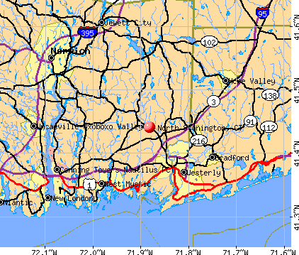
- OSM Map
- General Map
- Google Map
- MSN Map
Population change since 2000: +6.1%
 |
| Males: 2,687 | |
| Females: 2,610 |
| Median resident age: | 45.9 years |
| Connecticut median age: | 39.2 years |
Zip codes: 06359.
| North Stonington: | $94,908 |
| CT: | $88,429 |
Estimated per capita income in 2022: $46,289 (it was $25,815 in 2000)
North Stonington town income, earnings, and wages data
Estimated median house or condo value in 2022: $344,606 (it was $159,400 in 2000)
| North Stonington: | $344,606 |
| CT: | $347,200 |
Mean prices in 2022: all housing units: $336,024; detached houses: $358,368; townhouses or other attached units: $232,367; in 2-unit structures: $294,123; in 3-to-4-unit structures: $234,423; in 5-or-more-unit structures: $212,293; mobile homes: $38,564; occupied boats, rvs, vans, etc.: $86,722
North Stonington, CT residents, houses, and apartments details
Detailed information about poverty and poor residents in North Stonington, CT


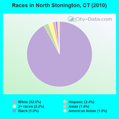
- 4,87292.0%White alone
- 1282.4%Hispanic
- 1152.2%Two or more races
- 751.4%Asian alone
- 521.0%Black alone
- 511.0%American Indian alone
- 30.06%Native Hawaiian and Other
Pacific Islander alone - 10.02%Other race alone
Races in North Stonington detailed stats: ancestries, foreign born residents, place of birth
According to our research of Connecticut and other state lists, there were 5 registered sex offenders living in North Stonington, Connecticut as of May 21, 2024.
The ratio of all residents to sex offenders in North Stonington is 1,059 to 1.
The ratio of registered sex offenders to all residents in this city is lower than the state average.
 Recent articles from our blog. Our writers, many of them Ph.D. graduates or candidates, create easy-to-read articles on a wide variety of topics.


Latest news from North Stonington, CT collected exclusively by city-data.com from local newspapers, TV, and radio stations
North Stonington, CT City Guides:
Ancestries: English (21.4%), Irish (18.5%), German (13.9%), Italian (11.3%), United States (9.1%), French (8.3%).
Current Local Time: EST time zone
Incorporated on 05/1807
Elevation: 140 feet
Land area: 54.3 square miles.
Population density: 98 people per square mile (very low).
107 residents are foreign born (1.3% Europe, 0.6% Asia, 0.3% Latin America).
| This town: | 2.1% |
| Connecticut: | 10.9% |
| North Stonington town: | 1.7% ($2,735) |
| Connecticut: | 1.8% ($2,961) |
Nearest city with pop. 50,000+: Warwick, RI  (30.3 miles , pop. 85,808).
Nearest city with pop. 200,000+: Boston, MA (72.6 miles , pop. 589,141).
Nearest city with pop. 1,000,000+: Bronx, NY (111.9 miles , pop. 1,332,650).
Nearest cities:
), ), ), ), )Latitude: 41.45 N, Longitude: 71.88 W
Area code commonly used in this area: 860


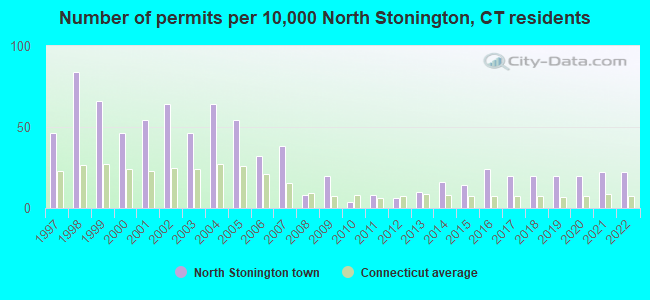
Single-family new house construction building permits:
- 2022: 11 buildings, average cost: $177,400
- 2021: 11 buildings, average cost: $177,400
- 2020: 10 buildings, average cost: $177,400
- 2019: 10 buildings, average cost: $177,400
- 2018: 10 buildings, average cost: $177,400
- 2017: 10 buildings, average cost: $177,400
- 2016: 12 buildings, average cost: $180,000
- 2015: 7 buildings, average cost: $180,400
- 2014: 8 buildings, average cost: $125,000
- 2013: 5 buildings, average cost: $261,000
- 2012: 3 buildings, average cost: $214,200
- 2011: 4 buildings, average cost: $81,500
- 2010: 2 buildings, average cost: $237,700
- 2009: 10 buildings, average cost: $190,300
- 2008: 4 buildings, average cost: $158,800
- 2007: 19 buildings, average cost: $141,900
- 2006: 16 buildings, average cost: $156,000
- 2005: 27 buildings, average cost: $179,900
- 2004: 32 buildings, average cost: $132,000
- 2003: 23 buildings, average cost: $153,700
- 2002: 32 buildings, average cost: $132,200
- 2001: 27 buildings, average cost: $113,000
- 2000: 23 buildings, average cost: $110,200
- 1999: 33 buildings, average cost: $106,600
- 1998: 42 buildings, average cost: $87,500
- 1997: 23 buildings, average cost: $92,100
| Here: | 3.4% |
| Connecticut: | 3.9% |
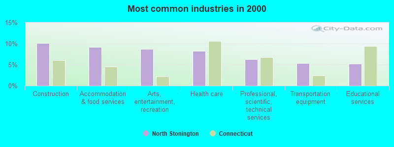
- Construction (10.1%)
- Accommodation & food services (9.2%)
- Arts, entertainment, recreation (8.8%)
- Health care (8.2%)
- Professional, scientific, technical services (6.2%)
- Transportation equipment (5.4%)
- Educational services (5.3%)
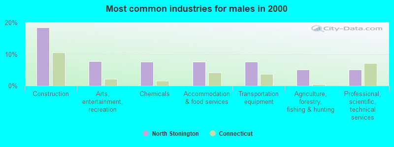
- Construction (18.5%)
- Arts, entertainment, recreation (7.8%)
- Chemicals (7.6%)
- Accommodation & food services (7.6%)
- Transportation equipment (7.5%)
- Agriculture, forestry, fishing & hunting (5.1%)
- Professional, scientific, technical services (5.1%)
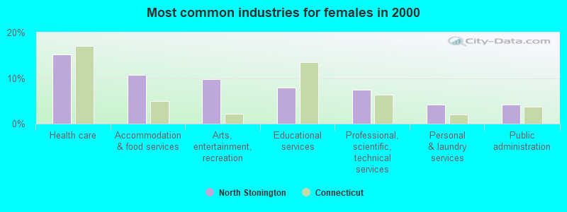
- Health care (15.3%)
- Accommodation & food services (10.8%)
- Arts, entertainment, recreation (9.8%)
- Educational services (7.9%)
- Professional, scientific, technical services (7.5%)
- Personal & laundry services (4.2%)
- Public administration (4.1%)
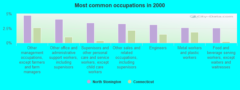
- Other management occupations, except farmers and farm managers (4.7%)
- Other office and administrative support workers, including supervisors (4.1%)
- Supervisors and other personal care and service workers, except child care workers (3.5%)
- Other sales and related occupations, including supervisors (3.3%)
- Engineers (3.1%)
- Metal workers and plastic workers (2.6%)
- Food and beverage serving workers, except waiters and waitresses (2.6%)
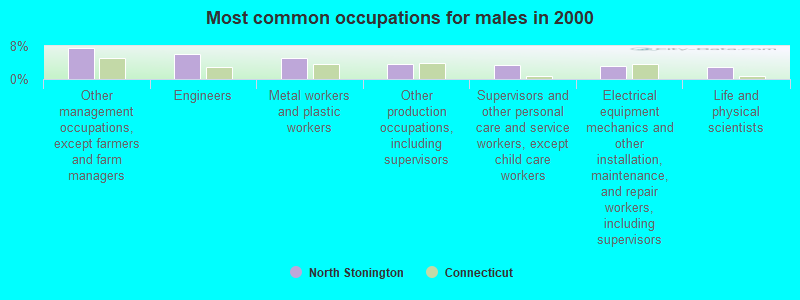
- Other management occupations, except farmers and farm managers (7.5%)
- Engineers (6.1%)
- Metal workers and plastic workers (5.1%)
- Other production occupations, including supervisors (3.6%)
- Supervisors and other personal care and service workers, except child care workers (3.3%)
- Electrical equipment mechanics and other installation, maintenance, and repair workers, including supervisors (3.1%)
- Life and physical scientists (3.0%)
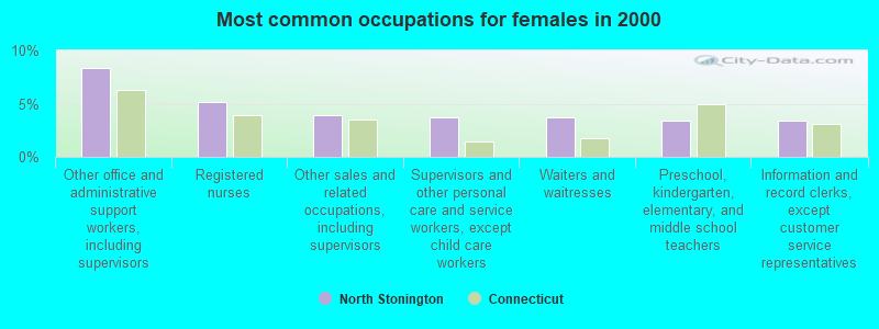
- Other office and administrative support workers, including supervisors (8.4%)
- Registered nurses (5.2%)
- Other sales and related occupations, including supervisors (4.0%)
- Supervisors and other personal care and service workers, except child care workers (3.7%)
- Waiters and waitresses (3.7%)
- Preschool, kindergarten, elementary, and middle school teachers (3.4%)
- Information and record clerks, except customer service representatives (3.4%)
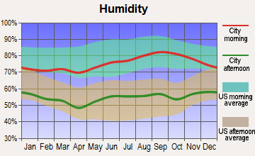
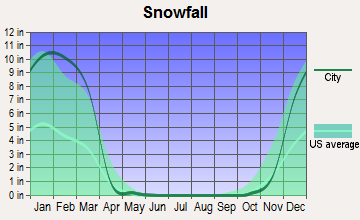
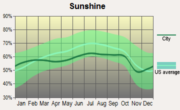
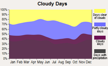
Average climate in North Stonington, Connecticut
Based on data reported by over 4,000 weather stations

(lower is better)
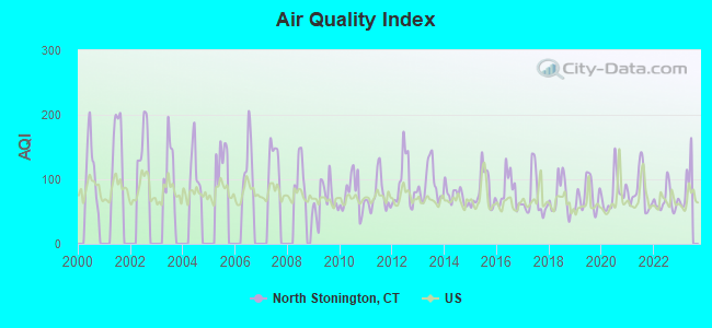
Air Quality Index (AQI) level in 2022 was 67.3. This is about average.
| City: | 67.3 |
| U.S.: | 72.6 |
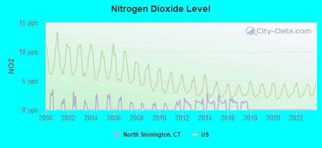
Nitrogen Dioxide (NO2) [ppb] level in 2017 was 1.35. This is significantly better than average. Closest monitor was 5.9 miles away from the city center.
| City: | 1.35 |
| U.S.: | 5.11 |
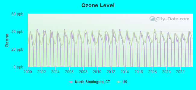
Ozone [ppb] level in 2022 was 31.8. This is about average. Closest monitor was 8.9 miles away from the city center.
| City: | 31.8 |
| U.S.: | 33.3 |
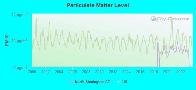
Particulate Matter (PM10) [µg/m3] level in 2022 was 12.6. This is significantly better than average. Closest monitor was 9.5 miles away from the city center.
| City: | 12.6 |
| U.S.: | 19.2 |
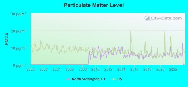
Particulate Matter (PM2.5) [µg/m3] level in 2022 was 5.21. This is significantly better than average. Closest monitor was 11.2 miles away from the city center.
| City: | 5.21 |
| U.S.: | 8.11 |
Tornado activity:
North Stonington-area historical tornado activity is below Connecticut state average. It is 53% smaller than the overall U.S. average.
On 10/3/1979, a category F4 (max. wind speeds 207-260 mph) tornado 50.3 miles away from the North Stonington town center killed 3 people and injured 500 people and caused between $50,000,000 and $500,000,000 in damages.
On 8/21/1951, a category F3 (max. wind speeds 158-206 mph) tornado 33.2 miles away from the town center injured 8 people and caused between $50,000 and $500,000 in damages.
Earthquake activity:
North Stonington-area historical earthquake activity is significantly above Connecticut state average. It is 73% smaller than the overall U.S. average.On 10/7/1983 at 10:18:46, a magnitude 5.3 (5.1 MB, 5.3 LG, 5.1 ML, Class: Moderate, Intensity: VI - VII) earthquake occurred 213.4 miles away from North Stonington center
On 4/20/2002 at 10:50:47, a magnitude 5.3 (5.3 ML, Depth: 3.0 mi) earthquake occurred 230.7 miles away from the city center
On 4/20/2002 at 10:50:47, a magnitude 5.2 (5.2 MB, 4.2 MS, 5.2 MW, 5.0 MW) earthquake occurred 229.5 miles away from the city center
On 1/19/1982 at 00:14:42, a magnitude 4.7 (4.5 MB, 4.7 MD, 4.5 LG, Class: Light, Intensity: IV - V) earthquake occurred 142.3 miles away from North Stonington center
On 10/16/2012 at 23:12:25, a magnitude 4.7 (4.7 ML, Depth: 10.0 mi) earthquake occurred 161.0 miles away from the city center
On 8/22/1992 at 12:20:32, a magnitude 4.8 (4.8 MB, 3.8 MS, 4.7 LG, Depth: 6.2 mi) earthquake occurred 182.1 miles away from the city center
Magnitude types: regional Lg-wave magnitude (LG), body-wave magnitude (MB), duration magnitude (MD), local magnitude (ML), surface-wave magnitude (MS), moment magnitude (MW)
Natural disasters:
The number of natural disasters in New London County (22) is greater than the US average (15).Major Disasters (Presidential) Declared: 12
Emergencies Declared: 10
Causes of natural disasters: Hurricanes: 6, Snowstorms: 5, Storms: 5, Floods: 4, Blizzards: 3, Winter Storms: 3, Snows: 2, Snowfall: 1, Tropical Storm: 1, Wind: 1 (Note: some incidents may be assigned to more than one category).
Hospitals and medical centers near North Stonington:
- WESTERLY HEALTH CENTER (Nursing Home, about 6 miles away; WESTERLY, RI)
- AVALON HEALTH CARE CENTER AT STONERIDGE (Nursing Home, about 7 miles away; MYSTIC, CT)
- PENDLETON HEALTH AND REHABILITATION CENTER (Nursing Home, about 7 miles away; MYSTIC, CT)
- WESTERLY NURSING HOME INC (Nursing Home, about 7 miles away; WESTERLY, RI)
- WESTERLY HOSPITAL Acute Care Hospitals (about 7 miles away; WESTERLY, RI)
- SOUTH REGION-DURANT/ RIVERVIEW UNIT (Hospital, about 8 miles away; MYSTIC, CT)
- SOUTH REGION-RAINBOW HOUSE (Hospital, about 8 miles away; MYSTIC, CT)
Amtrak stations near North Stonington:
- 5 miles: FOXWOOD CASINO (LEDYARD, ROUTE 2) - Bus Station
- 6 miles: WESTERLY (14 RAILROAD AVE.) . Services: ticket office, enclosed waiting area, public restrooms, public payphones, vending machines, paid short-term parking, call for car rental service, call for taxi service, public transit connection.
- 9 miles: MYSTIC (RTE. 1) . Services: enclosed waiting area, public restrooms, public payphones, free short-term parking, call for car rental service, call for taxi service, public transit connection.
Operable nuclear power plants near North Stonington:
- 16 miles: Millstone 1 and 2 in Waterford, CT.
- 16 miles: Millstone 3 in Waterford, CT.
Colleges/universities with over 2000 students nearest to North Stonington:
- Three Rivers Community College (about 13 miles; Norwich, CT; Full-time enrollment: 2,897)
- Connecticut College (about 13 miles; New London, CT; FT enrollment: 2,068)
- University of Rhode Island (about 19 miles; Kingston, RI; FT enrollment: 14,656)
- New England Institute of Technology (about 25 miles; East Greenwich, RI; FT enrollment: 3,183)
- Eastern Connecticut State University (about 26 miles; Willimantic, CT; FT enrollment: 4,985)
- Community College of Rhode Island (about 28 miles; Warwick, RI; FT enrollment: 10,500)
- Salve Regina University (about 31 miles; Newport, RI; FT enrollment: 2,349)
Public high schools in North Stonington:
Public elementary/middle school in North Stonington:
- TOTOKET VALLEY ELEMENTARY SCHOOL (Students: 490, Location: 1388 MIDDLETOWN AVENUE, Grades: 3-5)
Points of interest:
Notable locations in North Stonington: YMCA Camp (A), Baptist Camp (B), North Stonington Fire Company (C), Wheeler Library (D), North Stonington Town Hall (E), North Stonington Ambulance Association (F). Display/hide their locations on the map
Churches in North Stonington include: First Baptist Church (A), North Stonington Church (B), Saint Thomas Moore Church (C), Third Baptist Church (D). Display/hide their locations on the map
Cemeteries: Woodward Cemetery (1), Swan Cemetery (2), Stewart Hill Cemetery (3), Pendleton Cemetery (4), Maine Cemetery (5), Denison Cemetery (6), Davis Cemetery (7). Display/hide their locations on the map
Lakes, reservoirs, and swamps: Wyassup Lake (A), Gallup Pond (B), Hewitt Pond (C), Lewis Pond (D), Lake Of Isles (E), Spalding Pond (F), Shingle Mill Pond (G), Billings Lake (H). Display/hide their locations on the map
Streams, rivers, and creeks: Yawbucs Brook (A), Wyassup Brook (B), Phelps Brook (C), Prentice Brook (D), Shunock River (E), Ashaway River (F), Assekonk Brook (G), Glade Brook (H), Green Fall River (I). Display/hide their locations on the map
Parks in North Stonington include: Assekonk Swamp State Wildlife Management Area (1), North Stonington Town Recreation Area (2), North Stonington Village Historic District (3). Display/hide their locations on the map
Hotels: Hilltop Inn & Suites (373 Norwich Westerly Road Route 2) (1), Budget Inn (593 Providence New Londo) (2), Cedar Park Inn & Whirlpool Suites (85 Norwich Westerly Road) (3). Display/hide their approximate locations on the map
Birthplace of: John Denison Baldwin - Politician.
| This town: | 2.6 people |
| Connecticut: | 2.5 people |
| This town: | 76.1% |
| Whole state: | 66.3% |
| This town: | 6.9% |
| Whole state: | 6.6% |
Likely homosexual households (counted as self-reported same-sex unmarried-partner households)
- Lesbian couples: 0.2% of all households
- Gay men: 0.4% of all households
| This town: | 4.8% |
| Whole state: | 7.9% |
| This town: | 2.1% |
| Whole state: | 3.9% |
3 people in residential treatment centers for juveniles (non-correctional) in 2010
25 people in hospitals or wards for drug/alcohol abuse in 2000
Banks with branches in North Stonington (2011 data):
- Chelsea Groton Bank: North Stonington Branch at Holly Green Plaza Route 2, branch established on 1979/05/05. Info updated 2010/06/21: Bank assets: $836.6 mil, Deposits: $688.4 mil, headquarters in Norwich, CT, positive income, Mortgage Lending Specialization, 14 total offices
For population 15 years and over in North Stonington:
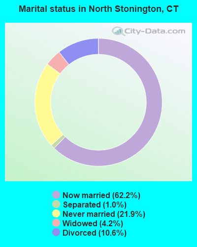
- Never married: 21.9%
- Now married: 62.2%
- Separated: 1.0%
- Widowed: 4.2%
- Divorced: 10.6%
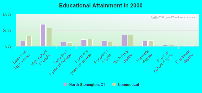
For population 25 years and over in North Stonington:
- High school or higher: 91.0%
- Bachelor's degree or higher: 29.3%
- Graduate or professional degree: 11.5%
- Unemployed: 3.8%
- Mean travel time to work (commute): 27.2 minutes
| Here: | 10.4 |
| Connecticut average: | 12.8 |
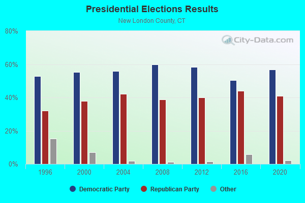
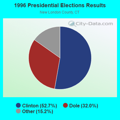
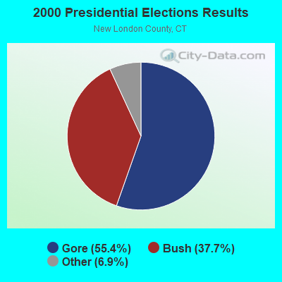

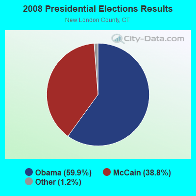

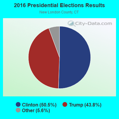
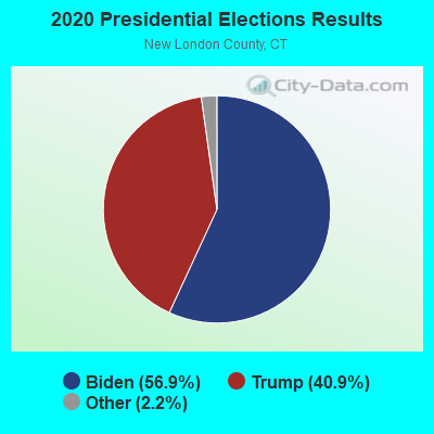
Graphs represent county-level data. Detailed 2008 Election Results
Political contributions by individuals in North Stonington, CT
Religion statistics for North Stonington, CT (based on New London County data)
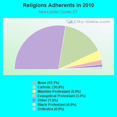
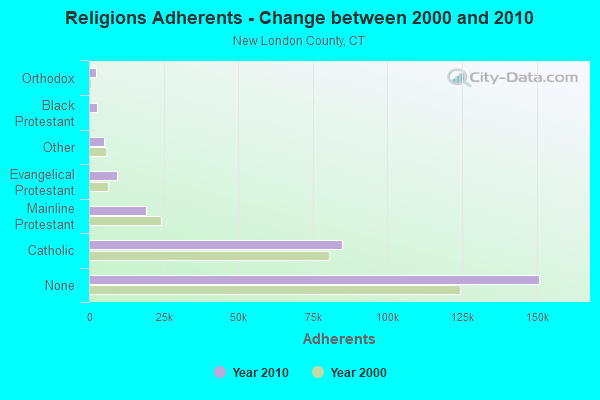
| Religion | Adherents | Congregations |
|---|---|---|
| Catholic | 84,765 | 34 |
| Mainline Protestant | 18,993 | 79 |
| Evangelical Protestant | 9,320 | 75 |
| Other | 5,022 | 32 |
| Black Protestant | 2,594 | 10 |
| Orthodox | 2,456 | 4 |
| None | 150,905 | - |
Food Environment Statistics:
| New London County: | 1.82 / 10,000 pop. |
| Connecticut: | 2.21 / 10,000 pop. |
| New London County: | 0.11 / 10,000 pop. |
| State: | 0.07 / 10,000 pop. |
| New London County: | 1.36 / 10,000 pop. |
| State: | 1.02 / 10,000 pop. |
| New London County: | 3.22 / 10,000 pop. |
| Connecticut: | 2.27 / 10,000 pop. |
| Here: | 10.01 / 10,000 pop. |
| State: | 9.19 / 10,000 pop. |
| New London County: | 7.6% |
| Connecticut: | 7.3% |
| New London County: | 22.4% |
| State: | 21.5% |
| This county: | 16.5% |
| Connecticut: | 15.8% |
6.16% of this county's 2021 resident taxpayers lived in other counties in 2020 ($81,025 average adjusted gross income)
| Here: | 6.16% |
| Connecticut average: | 5.79% |
0.04% of residents moved from foreign countries ($359 average AGI)
New London County: 0.04% Connecticut average: 0.02%
Top counties from which taxpayers relocated into this county between 2020 and 2021:
| from Hartford County, CT | |
| from Windham County, CT | |
| from Middlesex County, CT |
6.02% of this county's 2020 resident taxpayers moved to other counties in 2021 ($71,482 average adjusted gross income)
| Here: | 6.02% |
| Connecticut average: | 5.82% |
0.05% of residents moved to foreign countries ($502 average AGI)
New London County: 0.05% Connecticut average: 0.02%
Top counties to which taxpayers relocated from this county between 2020 and 2021:
| to Hartford County, CT | |
| to Windham County, CT | |
| to Middlesex County, CT |
| Businesses in North Stonington, CT | ||||
| Name | Count | Name | Count | |
|---|---|---|---|---|
| Dunkin Donuts | 2 | Subway | 1 | |
| FedEx | 1 | UPS | 2 | |
| McDonald's | 1 | |||
Strongest AM radio stations in North Stonington:
- WALE (990 AM; 50 kW; GREENVILLE, RI; Owner: NORTH AMERICAN BROADCASTING CO., INC.)
- WICH (1310 AM; 5 kW; NORWICH, CT; Owner: WICH, INCORPORATED)
- WJJF (1180 AM; daytime; 2 kW; HOPE VALLEY, RI; Owner: CHARLES RIVER BROADCASTING WJJF LICENSE CORPORATION)
- WXNI (1230 AM; 1 kW; WESTERLY, RI; Owner: WRNI FOUNDATION)
- WCRN (830 AM; 50 kW; WORCESTER, MA; Owner: CARTER BROADCASTING CORPORATION)
- WTIC (1080 AM; 50 kW; HARTFORD, CT; Owner: INFINITY RADIO OPERATIONS INC.)
- WNNZ (640 AM; 50 kW; WESTFIELD, MA; Owner: CLEAR CHANNEL BROADCASTING LICENSES, INC.)
- WEEI (850 AM; 50 kW; BOSTON, MA; Owner: ENTERCOM BOSTON LICENSE, LLC)
- WRKO (680 AM; 50 kW; BOSTON, MA; Owner: ENTERCOM BOSTON LICENSE, LLC)
- WKOX (1200 AM; 50 kW; FRAMINGHAM, MA; Owner: CAPSTAR TX LIMITED PARTNERSHIP)
- WVNE (760 AM; daytime; 25 kW; LEICESTER, MA; Owner: BLOUNT MASSCOM, INC.)
- WBIX (1060 AM; 40 kW; NATICK, MA; Owner: LANGER BROADCASTING CORPORATION)
- WSUB (980 AM; 1 kW; GROTON, CT; Owner: CITADEL BROADCASTING COMPANY)
Strongest FM radio stations in North Stonington:
- WHJM (107.7 FM; PAWCATUCK, CT; Owner: FULLER BROADCASTING INTERNATIONAL, LLC)
- WXLM (102.3 FM; STONINGTON, CT; Owner: CITADEL BROADCASTING COMPANY)
- WBMW (106.5 FM; LEDYARD, CT; Owner: RED WOLF BROADCASTING CORPORATION)
- WWRX-FM (103.7 FM; WESTERLY, RI; Owner: FNX BROADCASTING OF RHODE ISLAND, LLC)
- WCTY (97.7 FM; NORWICH, CT; Owner: WICH, INC.)
- WSKO-FM (99.7 FM; WAKEFIELD-PEACEDALE, RI; Owner: CITADEL BROADCASTING COMPANY)
- WQGN-FM (105.5 FM; GROTON, CT; Owner: CITADEL BROADCASTING COMPANY)
- WKNL (100.9 FM; NEW LONDON, CT; Owner: HALL COMMUNICATIONS, INC.)
- WRIU (90.3 FM; KINGSTON, RI; Owner: UNIVERSITY OF RHODE ISLAND)
- WNLC (98.7 FM; EAST LYME, CT; Owner: HALL COMMUNICATIONS, INC.)
- WILI-FM (98.3 FM; WILLIMANTIC, CT; Owner: NUTMEG BROADCASTING COMPANY)
- WWBB (101.5 FM; PROVIDENCE, RI; Owner: CLEAR CHANNEL BROADCASTING LICENSES, INC.)
- WCNI (90.9 FM; NEW LONDON, CT; Owner: CONNECTICUT COLLEGE BROADCASTING ASSOCIATION, INC.)
- WKKB (100.3 FM; MIDDLETOWN, RI; Owner: CITADEL BROADCASTING COMPANY)
- WECS (90.1 FM; WILLIMANTIC, CT; Owner: EASTERN CONNECTICUT STATE COLLEGE)
- WPRO-FM (92.3 FM; PROVIDENCE, RI; Owner: CITADEL BROADCASTING COMPANY)
- W233AG (94.5 FM; NEW LONDON, CT; Owner: MONROE BOARD OF EDUCATION)
- WAKX (102.7 FM; NARRAGANSETT PIER, RI; Owner: AAA ENTERTAINMENT LICENSING LLC)
- WBLQ (88.1 FM; WESTERLY, RI; Owner: SOUTHERN RI PUBLIC RADIO BROAD INC)
TV broadcast stations around North Stonington:
- WPXQ (Channel 69; BLOCK ISLAND, RI; Owner: OCEAN STATE TELEVISION, L.L.C.)
- WHPX (Channel 26; NEW LONDON, CT; Owner: PAXSON HARTFORD LICENSE, INC.)
- WEDN (Channel 53; NORWICH, CT; Owner: CONNECTICUT PUBLIC BROADCASTING, INC.)
- WTIC-TV (Channel 61; HARTFORD, CT; Owner: TRIBUNE TELEVISION COMPANY)
- WNAC-TV (Channel 64; PROVIDENCE, RI; Owner: WNAC, LLC)
- WPRI-TV (Channel 12; PROVIDENCE, RI; Owner: TVL BROADCASTING OF RHODE ISLAND, LLC)
- WRIW-LP (Channel 50; PROVIDENCE, RI; Owner: ZGS PROVIDENCE, INC.)
- National Bridge Inventory (NBI) Statistics
- 32Number of bridges
- 259ft / 79.0mTotal length
- $7,995,000Total costs
- 358,258Total average daily traffic
- 35,037Total average daily truck traffic
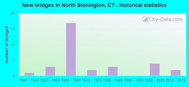
- New bridges - historical statistics
- 11940-1949
- 31950-1959
- 171960-1969
- 21970-1979
- 31980-1989
- 42000-2009
- 22010-2019
FCC Registered Cell Phone Towers:
3 (See the full list of FCC Registered Cell Phone Towers in North Stonington)FCC Registered Antenna Towers:
27 (See the full list of FCC Registered Antenna Towers)FCC Registered Private Land Mobile Towers:
5 (See the full list of FCC Registered Private Land Mobile Towers in North Stonington, CT)FCC Registered Broadcast Land Mobile Towers:
9 (See the full list of FCC Registered Broadcast Land Mobile Towers)FCC Registered Microwave Towers:
2- WINTECHOG, 6 Miles N Of (Lat: 41.460083 Lon: -71.925333), Overall height: 107.3 m, Call Sign: WBA962, Licensee ID: L00124340,
Assigned Frequencies: 5989.60 MHz, 6108.30 MHz, Grant Date: 03/06/2001, Expiration Date: 02/01/2011, Cancellation Date: 05/11/2004, Registrant: Comcast Of Clinton Ct, Inc., 1500 Market St., Philadelphia, PA 19102, Phone: (215) 665-1700, Fax: (215) 981-7820, Email:
- NORTH STONINGTON, 118a Wintechog Hill Road (Lat: 41.460917 Lon: -71.928944), Overall height: 107.3 m, Call Sign: WLT351, Licensee ID: L00115313,
Assigned Frequencies: 2174.80 MHz, Grant Date: 03/13/2001, Expiration Date: 02/01/2011, Cancellation Date: 06/09/2003, Certifier: Dennis W Guard Jr., Registrant: Intermedia Services, LLC (Debtor-In-Possession)
FCC Registered Paging Towers:
4- On Wintechog Hill (Lat: 41.459528 Lon: -71.928667), Call Sign: KNKD339,
Assigned Frequencies: 158.100 MHz, Grant Date: 04/27/1999, Expiration Date: 04/01/2009, Cancellation Date: 03/19/2009, Certifier: John T Scott Iii, Registrant: American Messaging Services, LLC, 1720 Lakepointe Drive, #100, Lewisville, TX 75057, Phone: (214) 222-6460, Fax: (972) 353-1912, Email:
- Wintechog Hill Rd. (Lat: 41.459806 Lon: -71.927833), Overall height: 64.6 m, Call Sign: KNKL830,
Assigned Frequencies: 931.487 MHz, Grant Date: 04/27/1999, Expiration Date: 06/15/2008, Cancellation Date: 11/02/2004, Certifier: William Buxbaum, Registrant: Network Services, LLC Debtor-In-Possession, 525 South Douglas Street, El Segundo, CA 90245, Phone: (310) 615-6523, Fax: (310) 615-6581, Email:
- Off Wintechog Road (Lat: 41.459528 Lon: -71.927000), Type: Tower, Structure height: 57 m, Call Sign: KNKM829, Licensee ID: L01422065,
Assigned Frequencies: 931.862 MHz, Grant Date: 08/12/2008, Expiration Date: 07/01/2018, Cancellation Date: 01/28/2014, Certifier: Shawn E Endsley, Registrant: Usa Mobility Wireless, Inc., 3000 Technology Dr. #400, Plano, TX 75074, Phone: (972) 801-0000, Fax: (972) 801-1699, Email:
- Wintechog Hill Road (Lat: 41.459278 Lon: -71.927861), Type: Tower, Structure height: 51.2 m, Overall height: 57.9 m, Call Sign: KNKM752,
Assigned Frequencies: 931.187 MHz, Grant Date: 04/19/1999, Expiration Date: 04/01/2009, Cancellation Date: 05/23/2009, Certifier: Shawn E Endsley, Registrant: Usa Mobility Wireless, Inc., 300 Technology Drive #400, Plano, TX 75074, Phone: (972) 801-1626, Fax: (972) 801-1699, Email:
FCC Registered Maritime Coast & Aviation Ground Towers:
1- 90 Wintechog Hill Rd (Lat: 41.452889 Lon: -71.917028), Type: Building, Overall height: 6 m, Call Sign: WQX639, Licensee ID: L00001725,
Assigned Frequencies: 156.450 MHz, 156.350 MHz, 156.800 MHz, Grant Date: 03/15/2005, Expiration Date: 06/01/2015, Cancellation Date: 08/01/2015, Registrant: Montauk Pilots Inc, 90 Wintechog Hill Rd, North Stonington, CT 06359, Phone: (860) 535-2066
FCC Registered Amateur Radio Licenses:
31 (See the full list of FCC Registered Amateur Radio Licenses in North Stonington)FAA Registered Aircraft:
2- Aircraft: SUD AVIATION SE3130 ALOUETTE II (Category: Land, Seats: 5, Weight: Up to 12,499 Pounds), Engine: TURBOMECA ARTOUSTE II (400 HP) (Turbo-shaft)
N-Number: 225RW, N225RW, N-225RW, Serial Number: 1312, Year manufactured: 1959, Airworthiness Date: 03/12/2009, Certificate Issue Date: 12/28/2012
Registrant (Individual): Charles S Dufton, 20 Pendleton Hl, North Stonington, CT 06359 - Aircraft: PIPER PA-30 (Category: Land, Engines: 2, Seats: 6, Weight: Up to 12,499 Pounds, Speed: 139 mph), Engine: LYCOMING IO-320 SERIES (150 HP) (Reciprocating)
N-Number: 8667Y, N8667Y, N-8667Y, Serial Number: 30-1809, Year manufactured: 1969, Airworthiness Date: 01/29/1969, Certificate Issue Date: 12/12/2015
Registrant (Co-Owned): Charles S Dufton, 20 Pendleton Hill Rd, North Stonington, CT 06359, Other Owners: Sarah D Smith-Dufton
2002 - 2018 National Fire Incident Reporting System (NFIRS) incidents
- Fire incident types reported to NFIRS in North Stonington, CT
- 22140.3%Outside Fires
- 19635.7%Structure Fires
- 10218.6%Mobile Property/Vehicle Fires
- 305.5%Other
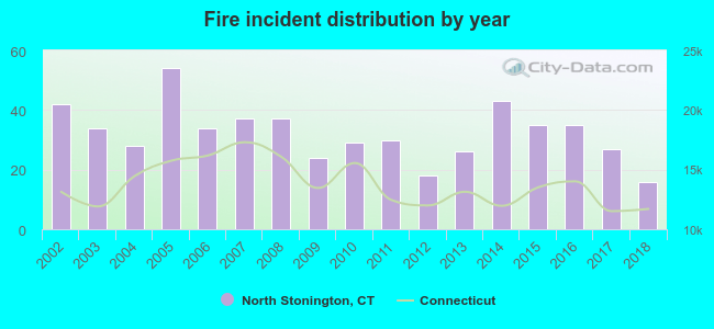 Based on the data from the years 2002 - 2018 the average number of fire incidents per year is 32. The highest number of reported fires - 54 took place in 2005, and the least - 16 in 2018. The data has a dropping trend.
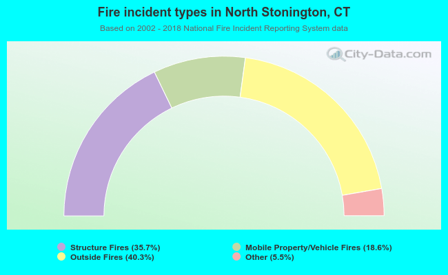 When looking into fire subcategories, the most reports belonged to: Outside Fires (40.3%), and Structure Fires (35.7%).
Fire-safe hotels and motels in North Stonington, Connecticut:
- Budget Inn, 593 Providence New London Tpke, North Stonington, Connecticut 06359 , Phone: (860) 599-0835
- Bellissimo Grande Hotel, 411 Norwich Westerly Rd, North Stonington, Connecticut 06359 , Phone: (860) 535-9924
- Cedar Park Inn & Whirlpool Suites, 85 Norwich Westerly Rd, North Stonington, Connecticut 06359 , Phone: (860) 535-7829, Fax: (860) 599-4759
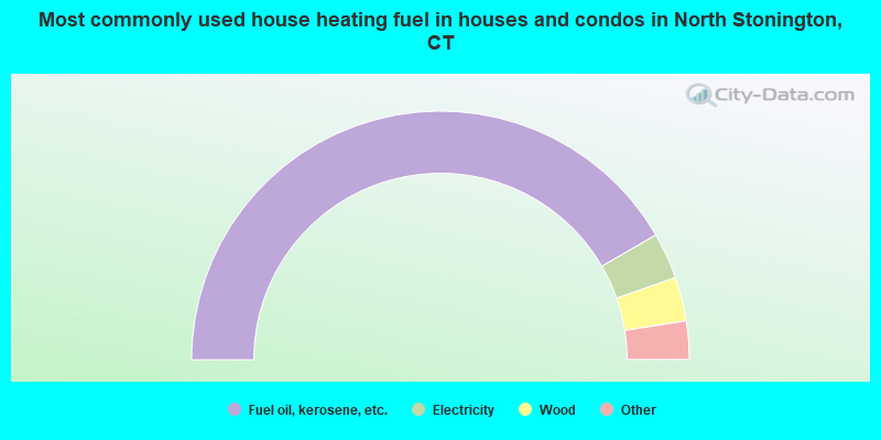
- 83.3%Fuel oil, kerosene, etc.
- 6.0%Electricity
- 5.7%Wood
- 3.7%Bottled, tank, or LP gas
- 0.9%Coal or coke
- 0.4%Other fuel
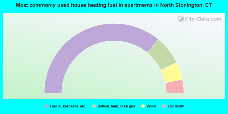
- 72.0%Fuel oil, kerosene, etc.
- 13.5%Bottled, tank, or LP gas
- 8.2%Wood
- 6.3%Electricity
North Stonington compared to Connecticut state average:
- Unemployed percentage significantly below state average.
- Black race population percentage significantly below state average.
- Hispanic race population percentage significantly below state average.
- Median age above state average.
- Foreign-born population percentage significantly below state average.
- Renting percentage significantly below state average.
- Length of stay since moving in significantly above state average.
- Number of rooms per house significantly below state average.
- House age significantly below state average.
- Number of college students below state average.
North Stonington on our top lists:
- #6 on the list of "Top 101 cities with largest percentage of females in occupations: librarians, curators, and archivists (population 5,000+)"
- #7 on the list of "Top 101 cities with largest percentage of males in occupations: communications equipment operators (population 5,000+)"
- #9 on the list of "Top 101 cities with largest percentage of males in occupations: food and beverage serving workers except waiters/waitresses (population 5,000+)"
- #10 on the list of "Top 101 cities with largest percentage of males in occupations: life and physical scientists (population 5,000+)"
- #16 on the list of "Top 101 cities with largest percentage of males in occupations: other transportation workers (population 5,000+)"
- #17 on the list of "Top 101 cities with largest percentage of males in industries: chemicals (population 5,000+)"
- #20 on the list of "Top 101 cities with largest percentage of males in occupations: supervisors and other personal care and service workers except personal appearance, transportation, and child care workers (population 5,000+)"
- #25 on the list of "Top 101 cities with largest percentage of males in industries: private households (population 5,000+)"
- #44 on the list of "Top 101 cities with the largest percentage of people in hospitals or wards for drug/alcohol abuse (population 1,000+)"
- #45 on the list of "Top 101 cities with largest percentage of females in industries: personal and laundry services (population 5,000+)"
- #50 on the list of "Top 101 cities with largest percentage of females in industries: data processing, libraries, and other information services (population 5,000+)"
- #53 on the list of "Top 101 cities with largest percentage of males in industries: gasoline stations (population 5,000+)"
- #63 on the list of "Top 101 cities with largest percentage of females in industries: music stores (population 5,000+)"
- #66 on the list of "Top 101 cities with largest percentage of males in industries: electrical equipment, appliances, and components (population 5,000+)"
- #70 on the list of "Top 101 cities with largest percentage of females in industries: motor vehicles, parts and supplies merchant wholesalers (population 5,000+)"
- #71 on the list of "Top 101 cities with largest percentage of females in industries: transportation equipment (population 5,000+)"
- #79 on the list of "Top 101 cities with largest percentage of males in industries: fuel dealers (population 5,000+)"
- #82 on the list of "Top 101 cities with largest percentage of males in industries: transportation equipment (population 5,000+)"
- #90 on the list of "Top 101 cities with largest percentage of females in industries: arts, entertainment, and recreation (population 5,000+)"
- #100 on the list of "Top 101 cities with largest percentage of males in industries: music stores (population 5,000+)"
- #16 on the list of "Top 101 counties with the lowest average weight of females"
- #28 on the list of "Top 101 counties with the highest percentage of residents that visited a dentist within the past year"
- #28 on the list of "Top 101 counties with highest percentage of residents voting for Obama (Democrat) in the 2012 Presidential Election"
- #51 on the list of "Top 101 counties with the lowest percentage of residents that drank alcohol in the past 30 days"
- #66 on the list of "Top 101 counties with the lowest percentage of residents that keep firearms around their homes"

|
|
Total of 95 patent applications in 2008-2024.