Bridge Statistics for Odessa, Texas (TX)
Condition, Traffic, Stress, Structural Evaluation, Project Costs
- National Bridge Inventory (NBI) Statistics
- 128Number of bridges
- 1,276ft / 389mTotal length
- $100,573,000Total costs
- 1,478,539Total average daily traffic
- 304,615Total average daily truck traffic
- National Bridge Inventory (NBI) Registered Bridges for Odessa
- No street view available for this location
- New bridges - historical statistics
- 21930-1939
- 21940-1949
- 11950-1959
- 671960-1969
- 71970-1979
- 201980-1989
- 151990-1999
- 122000-2009
- 22010-2019
- Reconstructed bridges - Historical Statistics
- 21940-1949
- 01950-1959
- 31960-1969
- 11970-1979
- 21980-1989
- 11990-1999
- 22000-2009
- 52010-2019

- Bridge Condition - Deck
- 58.5%Good
- 39.0%Satisfactory
- 2.4%Fair
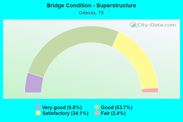
- Bridge Condition - Superstructure
- 9.8%Very good
- 53.7%Good
- 34.1%Satisfactory
- 2.4%Fair
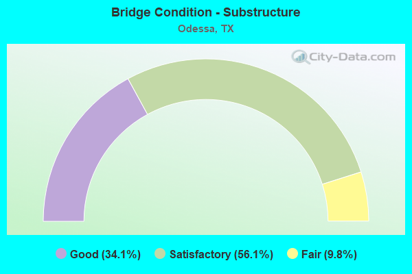
- Bridge Condition - Substructure
- 34.1%Good
- 56.1%Satisfactory
- 9.8%Fair
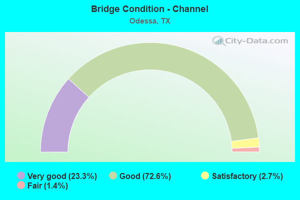
- Bridge Condition - Channel
- 23.3%Very good
- 72.6%Good
- 2.7%Satisfactory
- 1.4%Fair

- Bridge Condition - Culverts
- 58.3%Good
- 35.0%Satisfactory
- 6.7%Fair
Find on map >> Show street view
Structure Number: 60690B66714001, Location: 0.35 MI E OF SH 302 (Lat: 31.843292, Lng: -102.402417), Route carried "on" structure: City street , Year Built: 1961, Status: Open, Structure Length: 1.01m (3.31ft), Average Daily Traffic: 875 (year 2013), Average Future Daily Traffic: 1,000 (year 2032), Design Load: H 20, Features Intersected: W SIDE DRAINAGE CHANNEL, Facility Carried by Structure: PARK BLVD
Minimum Vertical Clearance: 30+ m (98+ ft), Kilometerpoint: 0.549, Lanes on structure: 2, Owner: City or Municipal Highway Agency, Approaching Roadway Width: 11.9m (39.0ft), Material/Design: Concrete, Design/Construction: Culvert, Number Of Spans In Main Unit: 3, Length of Maximum Span: 3.0m (9.8ft), Curb or Sidewalk Widths: Left: 1.4m (4.6ft), Right: 1.3m (4.3ft), Curb-To-Curb Width: 11.9m (39.0ft), Out-to-Out Width: 15.2m (49.9ft)
Condition: Channel: Good, Culverts: Good, Operating Rating: 39.9 metric tons, Method Used To Determine Operating Rating: Load Factor (LF), Inventory Rating: 23.6 metric tons, Method Used To Determine Inventory Rating: Load Factor (LF), Structural Evaluation: Equal to present minimum criteria, Deck Geometry: Better than present minimum criteria, Waterway Adequacy: Better than present minimum criteria, Approach Roadway Alignment: Equal to present desirable criteria, Designated Inspection Frequency: Every 24 months, Inspection Date: March 2021, Deck Structure Type: Concrete Cast-file-Place, Wearing Surface/Protective System: Wearing Surface: Bituminous
Find on map >> Show street view
Structure Number: 60690B66901001, Location: 0.9 MI SW OF LP 338 (Lat: 31.907425, Lng: -102.338383), Route carried "on" structure: City street , Year Built: 1999, Status: Open, Structure Length: 1.68m (5.51ft), Average Daily Traffic: 3,720 (year 2015), Truck Traffic: 1%, Average Future Daily Traffic: 20,000 (year 2037), Design Load: HS 20, Features Intersected: W SIDE DRAINAGE CHANNEL, Facility Carried by Structure: JBS PARKWAY
Minimum Vertical Clearance: 30+ m (98+ ft), Kilometerpoint: 1.448, Lanes on structure: 7, Owner: City or Municipal Highway Agency, Approaching Roadway Width: 27.1m (88.9ft), Skew: 3 degrees, Material/Design: Concrete, Design/Construction: Culvert, Number Of Spans In Main Unit: 5, Length of Maximum Span: 2.7m (8.9ft), Curb or Sidewalk Widths: Left: 1.4m (4.6ft), Right: 0.0m, Curb-To-Curb Width: 27.2m (89.2ft), Out-to-Out Width: 38.0m (124.7ft)
Condition: Channel: Very good, Culverts: Good, Operating Rating: 39.9 metric tons, Method Used To Determine Operating Rating: Load Factor (LF), Inventory Rating: 23.6 metric tons, Method Used To Determine Inventory Rating: Load Factor (LF), Structural Evaluation: Equal to present minimum criteria, Deck Geometry: Somewhat better than minimum adequacy, Waterway Adequacy: Superior to present desirable criteria, Approach Roadway Alignment: Equal to present desirable criteria, Designated Inspection Frequency: Every 24 months, Inspection Date: March 2021, Deck Structure Type: Concrete Cast-file-Place, Wearing Surface/Protective System: Wearing Surface: Bituminous
Find on map >> Show street view
Structure Number: 60690B67953001, Location: 0.10 MI W OF BOB WHITE (Lat: 31.879739, Lng: -102.315422), Route carried "on" structure: City street , Year Built: 1978, Status: Open, Structure Length: 1.19m (3.90ft), Average Daily Traffic: 804 (year 2013), Average Future Daily Traffic: 1,000 (year 2032), Design Load: H 20, Features Intersected: DRAINAGE CHANNEL, Facility Carried by Structure: PEPPERIDGE PLACE
Minimum Vertical Clearance: 30+ m (98+ ft), Kilometerpoint: 0.558, Lanes on structure: 2, Owner: City or Municipal Highway Agency, Approaching Roadway Width: 11.9m (39.0ft), Material/Design: Concrete, Design/Construction: Culvert, Number Of Spans In Main Unit: 4, Length of Maximum Span: 2.7m (8.9ft), Curb or Sidewalk Widths: Left: 1.3m (4.3ft), Right: 1.3m (4.3ft), Curb-To-Curb Width: 11.8m (38.7ft), Out-to-Out Width: 14.9m (48.9ft)
Condition: Channel: Good, Culverts: Fair, Operating Rating: 39.9 metric tons, Method Used To Determine Operating Rating: Load Factor (LF), Inventory Rating: 23.6 metric tons, Method Used To Determine Inventory Rating: Load Factor (LF), Structural Evaluation: Somewhat better than minimum adequacy, Deck Geometry: Better than present minimum criteria, Waterway Adequacy: Better than present minimum criteria, Approach Roadway Alignment: Equal to present desirable criteria, Designated Inspection Frequency: Every 24 months, Inspection Date: March 2021, Deck Structure Type: Concrete Cast-file-Place, Wearing Surface/Protective System: Wearing Surface: Bituminous
Find on map >> Show street view
Structure Number: 60690B68708001, Location: 0.10 MI W OF STONEY RIDGE (Lat: 31.893394, Lng: -102.306217), Route carried "on" structure: City street , Year Built: 1981, Status: Open, Structure Length: 0.85m (2.79ft), Average Daily Traffic: 425 (year 2015), Average Future Daily Traffic: 500 (year 2035), Design Load: H 20, Features Intersected: E SIDE DRAINAGE CHANNEL, Facility Carried by Structure: PIEDMONT ST
Minimum Vertical Clearance: 30+ m (98+ ft), Kilometerpoint: 0.237, Lanes on structure: 2, Owner: City or Municipal Highway Agency, Approaching Roadway Width: 11.9m (39.0ft), Material/Design: Concrete, Design/Construction: Culvert, Number Of Spans In Main Unit: 3, Length of Maximum Span: 2.7m (8.9ft), Curb or Sidewalk Widths: Left: 1.3m (4.3ft), Right: 1.2m (3.9ft), Curb-To-Curb Width: 11.9m (39.0ft), Out-to-Out Width: 14.9m (48.9ft)
Condition: Channel: Good, Culverts: Satisfactory, Operating Rating: 39.9 metric tons, Method Used To Determine Operating Rating: Load Factor (LF), Inventory Rating: 23.6 metric tons, Method Used To Determine Inventory Rating: Load Factor (LF), Structural Evaluation: Equal to present minimum criteria, Deck Geometry: Better than present minimum criteria, Waterway Adequacy: Better than present minimum criteria, Approach Roadway Alignment: Equal to present desirable criteria, Designated Inspection Frequency: Every 24 months, Inspection Date: March 2021, Deck Structure Type: Concrete Cast-file-Place, Wearing Surface/Protective System: Wearing Surface: Bituminous
Find on map >> Show street view
Structure Number: 60690B70104001, Location: 0.20 MI W OF US 385 (Lat: 31.828167, Lng: -102.359492), Route carried "on" structure: City street , Year Built: 1984, Status: Open, Structure Length: 1.07m (3.51ft), Average Daily Traffic: 2,100 (year 2013), Average Future Daily Traffic: 3,100 (year 2032), Design Load: H 20, Features Intersected: MUSKINGUM DRAW, Facility Carried by Structure: W POOL RD
Minimum Vertical Clearance: 30+ m (98+ ft), Kilometerpoint: 0.739, Lanes on structure: 2, Owner: City or Municipal Highway Agency, Approaching Roadway Width: 13.7m (44.9ft), Material/Design: Concrete, Design/Construction: Culvert, Number Of Spans In Main Unit: 4, Length of Maximum Span: 2.4m (7.9ft), Curb or Sidewalk Widths: Left: 1.3m (4.3ft), Right: 0.0m, Curb-To-Curb Width: 13.7m (44.9ft), Out-to-Out Width: 18.3m (60.0ft)
Condition: Channel: Good, Culverts: Satisfactory, Operating Rating: 39.9 metric tons, Method Used To Determine Operating Rating: Load Factor (LF), Inventory Rating: 23.6 metric tons, Method Used To Determine Inventory Rating: Load Factor (LF), Structural Evaluation: Equal to present minimum criteria, Deck Geometry: Superior to present desirable criteria, Waterway Adequacy: Better than present minimum criteria, Approach Roadway Alignment: Equal to present desirable criteria, Designated Inspection Frequency: Every 24 months, Inspection Date: March 2021, Deck Structure Type: Concrete Cast-file-Place, Wearing Surface/Protective System: Wearing Surface: Bituminous
Find on map >> Show street view
Structure Number: 60690B78301001, Location: 0.01 MI S OF W 22ND ST (Lat: 31.854603, Lng: -102.401994), Route carried "on" structure: City street , Year Built: 1961, Status: Open, Structure Length: 1.01m (3.31ft), Average Daily Traffic: 1,091 (year 2013), Average Future Daily Traffic: 1,300 (year 2032), Design Load: H 20, Features Intersected: W SIDE DRAINAGE CHANNEL, Facility Carried by Structure: SAN FERNANDO DR
Minimum Vertical Clearance: 30+ m (98+ ft), Kilometerpoint: 0.935, Lanes on structure: 2, Owner: City or Municipal Highway Agency, Approaching Roadway Width: 11.9m (39.0ft), Material/Design: Concrete, Design/Construction: Culvert, Number Of Spans In Main Unit: 3, Length of Maximum Span: 3.0m (9.8ft), Curb or Sidewalk Widths: Left: 1.4m (4.6ft), Right: 1.4m (4.6ft), Curb-To-Curb Width: 11.9m (39.0ft), Out-to-Out Width: 15.0m (49.2ft)
Condition: Channel: Good, Culverts: Good, Operating Rating: 39.9 metric tons, Method Used To Determine Operating Rating: Load Factor (LF), Inventory Rating: 23.6 metric tons, Method Used To Determine Inventory Rating: Load Factor (LF), Structural Evaluation: Equal to present minimum criteria, Deck Geometry: Equal to present minimum criteria, Waterway Adequacy: Better than present minimum criteria, Approach Roadway Alignment: Equal to present desirable criteria, Designated Inspection Frequency: Every 24 months, Inspection Date: March 2021, Deck Structure Type: Concrete Cast-file-Place, Wearing Surface/Protective System: Wearing Surface: Bituminous
Find on map >> Show street view
Structure Number: 60690B78501001, Location: 0.01 MI S OF W 22ND ST (Lat: 31.856167, Lng: -102.398547), Route carried "on" structure: City street , Year Built: 1961, Status: Open, Structure Length: 1.04m (3.41ft), Average Daily Traffic: 1,312 (year 2013), Average Future Daily Traffic: 1,356 (year 2032), Design Load: H 20, Features Intersected: W SIDE DRAINAGE CHANNEL, Facility Carried by Structure: SANTA MONICA AVE
Minimum Vertical Clearance: 30+ m (98+ ft), Kilometerpoint: 0.760, Lanes on structure: 2, Owner: City or Municipal Highway Agency, Approaching Roadway Width: 11.9m (39.0ft), Skew: 1 degrees, Material/Design: Concrete, Design/Construction: Culvert, Number Of Spans In Main Unit: 3, Length of Maximum Span: 3.0m (9.8ft), Curb or Sidewalk Widths: Left: 1.3m (4.3ft), Right: 1.3m (4.3ft), Curb-To-Curb Width: 11.9m (39.0ft), Out-to-Out Width: 15.1m (49.5ft)
Condition: Channel: Good, Culverts: Satisfactory, Operating Rating: 39.9 metric tons, Method Used To Determine Operating Rating: Load Factor (LF), Inventory Rating: 23.6 metric tons, Method Used To Determine Inventory Rating: Load Factor (LF), Structural Evaluation: Equal to present minimum criteria, Deck Geometry: Equal to present minimum criteria, Waterway Adequacy: Better than present minimum criteria, Approach Roadway Alignment: Equal to present desirable criteria, Designated Inspection Frequency: Every 24 months, Inspection Date: March 2021, Deck Structure Type: Concrete Cast-file-Place, Wearing Surface/Protective System: Wearing Surface: Bituminous
Find on map >> Show street view
Structure Number: 60690B78801001, Location: 0.01 MI S OF W 22ND ST (Lat: 31.854122, Lng: -102.403164), Route carried "on" structure: City street , Year Built: 1961, Status: Open, Structure Length: 1.01m (3.31ft), Average Daily Traffic: 550 (year 2013), Average Future Daily Traffic: 600 (year 2032), Design Load: H 20, Features Intersected: W SIDE DRAINAGE CHANNEL, Facility Carried by Structure: SANTA ROSA AVE
Minimum Vertical Clearance: 30+ m (98+ ft), Kilometerpoint: 0.340, Lanes on structure: 2, Owner: City or Municipal Highway Agency, Approaching Roadway Width: 11.9m (39.0ft), Material/Design: Concrete, Design/Construction: Culvert, Number Of Spans In Main Unit: 3, Length of Maximum Span: 3.0m (9.8ft), Curb or Sidewalk Widths: Left: 1.3m (4.3ft), Right: 1.3m (4.3ft), Curb-To-Curb Width: 11.9m (39.0ft), Out-to-Out Width: 15.1m (49.5ft)
Condition: Channel: Good, Culverts: Good, Operating Rating: 39.9 metric tons, Method Used To Determine Operating Rating: Load Factor (LF), Inventory Rating: 23.6 metric tons, Method Used To Determine Inventory Rating: Load Factor (LF), Structural Evaluation: Equal to present minimum criteria, Deck Geometry: Better than present minimum criteria, Waterway Adequacy: Better than present minimum criteria, Approach Roadway Alignment: Equal to present desirable criteria, Designated Inspection Frequency: Every 24 months, Inspection Date: March 2021, Deck Structure Type: Concrete Cast-file-Place, Wearing Surface/Protective System: Wearing Surface: Bituminous
Find on map >> Show street view
Structure Number: 60690B85301001, Location: 0.20 MI N OF SH 191 (Lat: 31.895172, Lng: -102.343006), Route carried "on" structure: City street , Year Built: 1980, Status: Open, Structure Length: 0.85m (2.79ft), Average Daily Traffic: 9,500 (year 2015), Average Future Daily Traffic: 15,000 (year 2037), Design Load: H 20, Features Intersected: DRAINAGE CHANNEL, Facility Carried by Structure: TANGLEWOOD LN
Minimum Vertical Clearance: 30+ m (98+ ft), Kilometerpoint: 0.805, Lanes on structure: 5, Owner: City or Municipal Highway Agency, Approaching Roadway Width: 20.4m (66.9ft), Material/Design: Concrete, Design/Construction: Culvert, Number Of Spans In Main Unit: 5, Length of Maximum Span: 1.5m (4.9ft), Curb or Sidewalk Widths: Left: 1.2m (3.9ft), Right: 1.2m (3.9ft), Curb-To-Curb Width: 20.4m (66.9ft), Out-to-Out Width: 27.4m (89.9ft)
Condition: Channel: Good, Culverts: Good, Operating Rating: 39.9 metric tons, Method Used To Determine Operating Rating: Load Factor (LF), Inventory Rating: 23.6 metric tons, Method Used To Determine Inventory Rating: Load Factor (LF), Structural Evaluation: Somewhat better than minimum adequacy, Deck Geometry: Somewhat better than minimum adequacy, Waterway Adequacy: Better than present minimum criteria, Approach Roadway Alignment: Equal to present desirable criteria, Designated Inspection Frequency: Every 24 months, Inspection Date: March 2021, Deck Structure Type: Concrete Cast-file-Place, Wearing Surface/Protective System: Wearing Surface: Bituminous
Find on map >> Show street view
Structure Number: 60690B90403001, Location: 0.15 MI W OF E LOOP 338 (Lat: 31.882844, Lng: -102.316350), Route carried "on" structure: City street , Year Built: 1970, Status: Open, Structure Length: 0.98m (3.22ft), Average Daily Traffic: 17,090 (year 2015), Average Future Daily Traffic: 20,000 (year 2037), Features Intersected: DRAINAGE CHANNEL, Facility Carried by Structure: E UNIVERSITY BLVD
Minimum Vertical Clearance: 30+ m (98+ ft), Kilometerpoint: 9.173, Lanes on structure: 7, Owner: City or Municipal Highway Agency, Approaching Roadway Width: 26.5m (86.9ft), Material/Design: Concrete, Design/Construction: Culvert, Number Of Spans In Main Unit: 3, Length of Maximum Span: 3.0m (9.8ft), Curb or Sidewalk Widths: Left: 1.3m (4.3ft), Right: 0.9m (3.0ft), Curb-To-Curb Width: 26.5m (86.9ft), Out-to-Out Width: 29.3m (96.1ft)
Condition: Channel: Good, Culverts: Good, Operating Rating: 32.7 metric tons, Method Used To Determine Operating Rating: Field evaluation and documented engineering judgment, Inventory Rating: 24.5 metric tons, Method Used To Determine Inventory Rating: Field evaluation and documented engineering judgment, Structural Evaluation: Equal to present minimum criteria, Deck Geometry: Meets minimum limits, Waterway Adequacy: Equal to present minimum criteria, Approach Roadway Alignment: Equal to present desirable criteria, Designated Inspection Frequency: Every 24 months, Inspection Date: March 2021, Deck Structure Type: Concrete Cast-file-Place, Wearing Surface/Protective System: Wearing Surface: Bituminous
Find on map >> Show street view
Structure Number: 60690B98105001, Location: 0.80 MI E OF FM 1882 (Lat: 31.909683, Lng: -102.397244), Route carried "on" structure: City street , Year Built: 1988, Status: Open, Structure Length: 1.22m (4.00ft), Average Daily Traffic: 9,280 (year 2015), Average Future Daily Traffic: 8,000 (year 2037), Design Load: HS 20, Features Intersected: DRAINAGE DITCH, Facility Carried by Structure: YUKON RD
Minimum Vertical Clearance: 30+ m (98+ ft), Kilometerpoint: 2.092, Lanes on structure: 3, Owner: City or Municipal Highway Agency, Approaching Roadway Width: 20.7m (67.9ft), Material/Design: Concrete, Design/Construction: Culvert, Number Of Spans In Main Unit: 6, Length of Maximum Span: 1.8m (5.9ft), Curb-To-Curb Width: 20.7m (67.9ft), Out-to-Out Width: 33.3m (109.3ft)
Condition: Channel: Good, Culverts: Good, Operating Rating: 39.9 metric tons, Method Used To Determine Operating Rating: Load Factor (LF), Inventory Rating: 23.6 metric tons, Method Used To Determine Inventory Rating: Load Factor (LF), Structural Evaluation: Somewhat better than minimum adequacy, Deck Geometry: Superior to present desirable criteria, Waterway Adequacy: Equal to present minimum criteria, Approach Roadway Alignment: Equal to present desirable criteria, Designated Inspection Frequency: Every 24 months, Inspection Date: March 2021, Deck Structure Type: Concrete Cast-file-Place, Wearing Surface/Protective System: Wearing Surface: Bituminous
Find on map >> Show street view
Structure Number: 6165000051416, Location: 1.45 MI SW OF FM 1788 (Lat: 31.900500, Lng: -102.236381), Route carried "on" structure: Interstate 20, Year Built: 1965, Status: Open, Structure Length: 0.85m (2.79ft), Average Daily Traffic: 48,485 (year 2019), Truck Traffic: 27%, Average Future Daily Traffic: 45,340 (year 2033), Design Load: HS 20, Features Intersected: DRAW
Minimum Vertical Clearance: 30+ m (98+ ft), Kilometerpoint: 5.629, Lanes on structure: 4, Base Highway Network: Yes, Owner: State Highway Agency, Approaching Roadway Width: 23.2m (76.1ft), Skew: 20 degrees, Material/Design: Concrete, Design/Construction: Culvert, Number Of Spans In Main Unit: 5, Length of Maximum Span: 1.5m (4.9ft), Out-to-Out Width: 36.6m (120.1ft)
Condition: Channel: Good, Culverts: Satisfactory, Operating Rating: 39.9 metric tons, Method Used To Determine Operating Rating: Load Factor (LF), Inventory Rating: 23.6 metric tons, Method Used To Determine Inventory Rating: Load Factor (LF), Structural Evaluation: Somewhat better than minimum adequacy, Waterway Adequacy: Superior to present desirable criteria, Approach Roadway Alignment: Equal to present desirable criteria, Designated Inspection Frequency: Every 24 months, Inspection Date: Febuary 2021
Find on map >> Show street view
Structure Number: 61650229602006, Location: 3.25 MI SW OF SH 349 (Lat: 31.930661, Lng: -102.282489), Route carried "on" structure: ServiceState highway 191, Year Built: 1983, Year Reconstructed: 2016, Status: Open, Structure Length: 0.91m (2.99ft), Average Daily Traffic: 1,980 (year 2017), Truck Traffic: 4%, Average Future Daily Traffic: 2,770 (year 2037), Features Intersected: DRAIN
Minimum Vertical Clearance: 30+ m (98+ ft), Kilometerpoint: 2.326, Lanes on structure: 3, Owner: State Highway Agency, Approaching Roadway Width: 13.4m (44.0ft), Material/Design: Concrete, Design/Construction: Culvert, Number Of Spans In Main Unit: 4, Length of Maximum Span: 2.1m (6.9ft), Out-to-Out Width: 21.5m (70.5ft)
Condition: Channel: Very good, Culverts: Good, Operating Rating: 32.7 metric tons, Method Used To Determine Operating Rating: Field evaluation and documented engineering judgment, Inventory Rating: 24.5 metric tons, Method Used To Determine Inventory Rating: Field evaluation and documented engineering judgment, Structural Evaluation: Equal to present minimum criteria, Waterway Adequacy: Equal to present minimum criteria, Approach Roadway Alignment: Equal to present desirable criteria, Designated Inspection Frequency: Every 24 months, Inspection Date: Febuary 2021
Find on map >> Show street view
Structure Number: 61650229602007, Location: 2.60 MI SW OF SH 349 (Lat: 31.938542, Lng: -102.276322), Route carried "on" structure: ServiceState highway 191, Year Built: 1983, Status: Open, Structure Length: 1.16m (3.81ft), Average Daily Traffic: 1,980 (year 2017), Truck Traffic: 4%, Average Future Daily Traffic: 2,770 (year 2037), Features Intersected: DRAIN
Minimum Vertical Clearance: 30+ m (98+ ft), Kilometerpoint: 3.375, Lanes on structure: 2, Owner: State Highway Agency, Approaching Roadway Width: 9.8m (32.2ft), Material/Design: Concrete, Design/Construction: Culvert, Number Of Spans In Main Unit: 5, Length of Maximum Span: 2.1m (6.9ft), Out-to-Out Width: 17.5m (57.4ft)
Condition: Channel: Very good, Culverts: Good, Operating Rating: 32.7 metric tons, Method Used To Determine Operating Rating: Field evaluation and documented engineering judgment, Inventory Rating: 24.5 metric tons, Method Used To Determine Inventory Rating: Field evaluation and documented engineering judgment, Structural Evaluation: Equal to present minimum criteria, Waterway Adequacy: Equal to present minimum criteria, Approach Roadway Alignment: Equal to present desirable criteria, Designated Inspection Frequency: Every 24 months, Inspection Date: Febuary 2021
Find on map >> Show street view
Structure Number: 61650229602015, Location: 0.45 MI NE OF ECTOR C/L (Lat: 31.930831, Lng: -102.282981), Route carried "on" structure: State highway 191, Year Built: 1992, Status: Open, Structure Length: 1.16m (3.81ft), Average Daily Traffic: 5,000 (year 2014), Truck Traffic: 20%, Average Future Daily Traffic: 7,500 (year 2034), Design Load: HS 20, Features Intersected: DRAIN
Minimum Vertical Clearance: 30+ m (98+ ft), Kilometerpoint: 2.326, Lanes on structure: 4, Owner: State Highway Agency, Approaching Roadway Width: 24.4m (80.1ft), Skew: 20 degrees, Material/Design: Concrete, Design/Construction: Culvert, Number Of Spans In Main Unit: 5, Length of Maximum Span: 2.1m (6.9ft)
Condition: Channel: Very good, Culverts: Good, Operating Rating: 39.9 metric tons, Method Used To Determine Operating Rating: Load Factor (LF), Inventory Rating: 23.6 metric tons, Method Used To Determine Inventory Rating: Load Factor (LF), Structural Evaluation: Somewhat better than minimum adequacy, Waterway Adequacy: Equal to present minimum criteria, Approach Roadway Alignment: Equal to present desirable criteria, Designated Inspection Frequency: Every 48 months, Inspection Date: July 2018
Find on map >> Show street view
Structure Number: 61650229602016, Location: 1.1 MI NE OF ECTOR C/L (Lat: 31.938814, Lng: -102.276706), Route carried "on" structure: State highway 191, Year Built: 1992, Status: Open, Structure Length: 1.40m (4.59ft), Average Daily Traffic: 5,000 (year 2014), Truck Traffic: 25%, Average Future Daily Traffic: 7,500 (year 2034), Design Load: HS 20, Features Intersected: DRAIN
Minimum Vertical Clearance: 30+ m (98+ ft), Kilometerpoint: 3.375, Lanes on structure: 5, Owner: State Highway Agency, Approaching Roadway Width: 29.0m (95.1ft), Skew: 20 degrees, Material/Design: Concrete, Design/Construction: Culvert, Number Of Spans In Main Unit: 6, Length of Maximum Span: 2.1m (6.9ft)
Condition: Channel: Very good, Culverts: Good, Operating Rating: 39.9 metric tons, Method Used To Determine Operating Rating: Load Factor (LF), Inventory Rating: 23.6 metric tons, Method Used To Determine Inventory Rating: Load Factor (LF), Structural Evaluation: Somewhat better than minimum adequacy, Waterway Adequacy: Equal to present minimum criteria, Approach Roadway Alignment: Equal to present desirable criteria, Designated Inspection Frequency: Every 48 months, Inspection Date: July 2018
Find on map >> Show street view
Structure Number: 6069000040704, Location: 1.85 MI W OF US 385 (Lat: 31.818531, Lng: -102.382369), Route carried "under" structure: State highway 1882, Year Built: 1966, Structure Length: 0. m, Average Daily Traffic: 16,720 (year 2013), Truck Traffic: 22%, Features Intersected: FM 1882, Facility Carried by Structure: IH 20 WB
Minimum Vertical Clearance: 5.21m (17.09ft), Kilometerpoint: 9.968, Lanes on structure: 2, Lanes under structure: 4, Material/Design: Prestressed concrete, Design/Construction: Stringer/Multi-beam, Length of Maximum Span: 16.8m (55.1ft)
Find on map >> Show street view
Structure Number: 60690000407041, Location: 1.85 MI W OF US 385 (Lat: 31.818353, Lng: -102.382314), Route carried "under" structure: State highway 1882, Year Built: 1966, Structure Length: 0. m, Average Daily Traffic: 16,720 (year 2013), Truck Traffic: 22%, Features Intersected: FM 1882, Facility Carried by Structure: IH 20 EB
Minimum Vertical Clearance: 5.26m (17.26ft), Kilometerpoint: 10.004, Lanes on structure: 2, Lanes under structure: 4, Material/Design: Prestressed concrete, Design/Construction: Stringer/Multi-beam, Length of Maximum Span: 16.8m (55.1ft)
Find on map >> Show street view
Structure Number: 60690000407227, Location: 0.70 MI W. OF US 385 (Lat: 31.824031, Lng: -102.366389), Route carried "under" structure: Interstate 20, Year Built: 2016, Structure Length: 0. m, Average Daily Traffic: 33,810 (year 2013), Truck Traffic: 31%, Features Intersected: IH 20, Facility Carried by Structure: CRANE AVENUE
Minimum Vertical Clearance: 5.05m (16.57ft), Kilometerpoint: 54.858, Lanes on structure: 4, Lanes under structure: 6, Material/Design: Prestressed concrete, Design/Construction: Stringer/Multi-beam, Length of Maximum Span: 19.8m (65.0ft)
Find on map >> Show street view
Structure Number: 60690000501106, Location: 0.8 Mi W of LP 338 (Lat: 31.867244, Lng: -102.319897), Route carried "under" structure: State highway 20, Year Built: 2009, Structure Length: 0. m, Average Daily Traffic: 15,300 (year 2015), Truck Traffic: 5%, Features Intersected: BI 20 E & UP RR, Facility Carried by Structure: JBS Parkway
Minimum Vertical Clearance: 6.86m (22.51ft), Kilometerpoint: 20.183, Lanes on structure: 4, Lanes under structure: 9, Material/Design: Steel continuous, Design/Construction: Stringer/Multi-beam, Length of Maximum Span: 30.2m (99.1ft)
Find on map >> Show street view
Structure Number: 60690000501107, Location: 0.8 Mi W of E LP 338 (Lat: 31.869117, Lng: -102.320117), Route carried "under" structure: Ramp State highway 20, Year Built: 2009, Structure Length: 0. m, Average Daily Traffic: 7,650 (year 2015), Truck Traffic: 2%, Features Intersected: BI-20 E W-E Turnaroud
Minimum Vertical Clearance: 6.17m (20.24ft), Kilometerpoint: 20.250, Lanes on structure: 3, Lanes under structure: 1, Material/Design: Prestressed concrete, Design/Construction: Stringer/Multi-beam, Length of Maximum Span: 33.5m (109.9ft)
Find on map >> Show street view
Structure Number: 60690000501224, Location: 1.6 MI E OF US 385 (Lat: 31.856456, Lng: -102.344419), Route carried "under" structure: City street , Year Built: 1969, Structure Length: 0. m, Average Daily Traffic: 4,911 (year 2011), Truck Traffic: 37%, Features Intersected: GRANDVIEW AVE, Facility Carried by Structure: IH 20 BUS (US 80)
Minimum Vertical Clearance: 5.08m (16.67ft), Kilometerpoint: 0.000, Lanes on structure: 5, Lanes under structure: 4, Material/Design: Prestressed concrete, Design/Construction: Stringer/Multi-beam, Length of Maximum Span: 14.6m (47.9ft)
Find on map >> Show street view
Structure Number: 60690000513004, Location: 1.02 MI W LP 338 EAST (Lat: 31.855514, Lng: -102.316322), Route carried "under" structure: State highway 20, Year Built: 2007, Structure Length: 0. m, Average Daily Traffic: 15,480 (year 2015), Truck Traffic: 3%, Features Intersected: JBS PARKWAY
Minimum Vertical Clearance: 5.33m (17.49ft), Kilometerpoint: 62.253, Lanes on structure: 4, Lanes under structure: 4, Material/Design: Prestressed concrete, Design/Construction: Stringer/Multi-beam, Length of Maximum Span: 32.0m (105.0ft)
Find on map >> Show street view
Structure Number: 6069000051317, Location: IH 20 AT US 385 (Lat: 31.828242, Lng: -102.355475), Route carried "under" structure: US 385, Year Built: 1966, Structure Length: 0. m, Average Daily Traffic: 11,410 (year 2015), Truck Traffic: 7%, Features Intersected: US 385, Facility Carried by Structure: IH 20 WB
Minimum Vertical Clearance: 5.41m (17.75ft), Kilometerpoint: 2.248, Lanes on structure: 2, Lanes under structure: 6, Material/Design: Prestressed concrete, Design/Construction: Stringer/Multi-beam, Length of Maximum Span: 16.8m (55.1ft)
Find on map >> Show street view
Structure Number: 60690000513171, Location: IH 20 AT US 385 (Lat: 31.828072, Lng: -102.355389), Route carried "under" structure: US 385, Year Built: 1966, Structure Length: 0. m, Average Daily Traffic: 5,240 (year 2015), Truck Traffic: 10%, Features Intersected: US 385, Facility Carried by Structure: IH 20 EB
Minimum Vertical Clearance: 5.51m (18.08ft), Kilometerpoint: 2.280, Lanes on structure: 2, Lanes under structure: 6, Material/Design: Prestressed concrete, Design/Construction: Stringer/Multi-beam, Length of Maximum Span: 16.8m (55.1ft)
Find on map >> Show street view
Structure Number: 60690000513172, Location: 0.35 MI E OF US 385 (Lat: 31.829525, Lng: -102.349739), Route carried "under" structure: City street , Year Built: 1966, Structure Length: 0. m, Average Daily Traffic: 3,790 (year 2015), Truck Traffic: 3%, Features Intersected: DIXIE BLVD, Facility Carried by Structure: IH 20 WB
Minimum Vertical Clearance: 4.95m (16.24ft), Kilometerpoint: 56.523, Lanes on structure: 2, Lanes under structure: 5, Material/Design: Steel continuous, Design/Construction: Stringer/Multi-beam, Length of Maximum Span: 24.4m (80.1ft)
Find on map >> Show street view
Structure Number: 60690000513173, Location: 0.35 MI E OF US 385 (Lat: 31.829356, Lng: -102.349653), Route carried "under" structure: City street , Year Built: 1966, Structure Length: 0. m, Average Daily Traffic: 3,790 (year 2015), Truck Traffic: 3%, Features Intersected: DIXIE BLVD, Facility Carried by Structure: IH 20 EB
Minimum Vertical Clearance: 5.05m (16.57ft), Kilometerpoint: 56.523, Lanes on structure: 2, Lanes under structure: 5, Material/Design: Steel continuous, Design/Construction: Stringer/Multi-beam, Length of Maximum Span: 24.4m (80.1ft)
Find on map >> Show street view
Structure Number: 60690000513174, Location: 1.20 MI E OF US 385 (Lat: 31.835736, Lng: -102.338033), Route carried "under" structure: State highway 3503, Year Built: 1966, Structure Length: 0. m, Average Daily Traffic: 3,800 (year 2015), Truck Traffic: 21%, Features Intersected: FM 3503 (GRANDVIEW AVE), Facility Carried by Structure: IH 20 WB
Minimum Vertical Clearance: 5.59m (18.34ft), Kilometerpoint: 0.056, Lanes on structure: 2, Lanes under structure: 4, Material/Design: Prestressed concrete, Design/Construction: Stringer/Multi-beam, Length of Maximum Span: 19.8m (65.0ft)
Find on map >> Show street view
Structure Number: 60690000513175, Location: 1.20 MI E OF US 385 (Lat: 31.835533, Lng: -102.337967), Route carried "under" structure: State highway 3503, Year Built: 1966, Structure Length: 0. m, Average Daily Traffic: 3,800 (year 2015), Truck Traffic: 21%, Features Intersected: FM 3503 (GRANDVIEW AVE), Facility Carried by Structure: IH 20 EB
Minimum Vertical Clearance: 5.41m (17.75ft), Kilometerpoint: 0.056, Lanes on structure: 2, Lanes under structure: 4, Material/Design: Prestressed concrete, Design/Construction: Stringer/Multi-beam, Length of Maximum Span: 19.8m (65.0ft)
Find on map >> Show street view
Structure Number: 60690000513178, Location: 1.40 MI E OF US 385 (Lat: 31.837867, Lng: -102.335678), Route carried "under" structure: State highway , Year Built: 1966, Structure Length: 0. m, Average Daily Traffic: 1,360 (year 2015), Truck Traffic: 3%, Features Intersected: INDUSTRIAL AVE, Facility Carried by Structure: IH 20 WB
Minimum Vertical Clearance: 5.41m (17.75ft), Kilometerpoint: 58.223, Lanes on structure: 2, Lanes under structure: 2, Material/Design: Prestressed concrete, Design/Construction: Stringer/Multi-beam, Length of Maximum Span: 16.8m (55.1ft)
Find on map >> Show street view
Structure Number: 60690000513179, Location: 1.40 MI E OF US 385 (Lat: 31.837664, Lng: -102.335611), Route carried "under" structure: State highway , Year Built: 1966, Structure Length: 0. m, Average Daily Traffic: 1,360 (year 2015), Truck Traffic: 3%, Features Intersected: INDUSTRIAL AVE, Facility Carried by Structure: IH 20 EB
Minimum Vertical Clearance: 5.79m (19.00ft), Kilometerpoint: 58.223, Lanes on structure: 2, Lanes under structure: 2, Material/Design: Prestressed concrete, Design/Construction: Stringer/Multi-beam, Length of Maximum Span: 16.8m (55.1ft)
Find on map >> Show street view
Structure Number: 60690000513185, Location: 4.15 MI E OF US 385 (Lat: 31.866603, Lng: -102.301878), Route carried "under" structure: State highway 338, Year Built: 1966, Structure Length: 0. m, Average Daily Traffic: 15,680 (year 2013), Truck Traffic: 6%, Features Intersected: LOOP 338, Facility Carried by Structure: IH 20 WB
Minimum Vertical Clearance: 5.16m (16.93ft), Kilometerpoint: 49.611, Lanes on structure: 2, Lanes under structure: 4, Material/Design: Prestressed concrete, Design/Construction: Stringer/Multi-beam, Length of Maximum Span: 15.2m (49.9ft)
Find on map >> Show street view
Structure Number: 60690000513186, Location: 4.15 MI E OF US 385 (Lat: 31.866125, Lng: -102.302167), Route carried "under" structure: State highway 338, Year Built: 1966, Structure Length: 0. m, Average Daily Traffic: 15,680 (year 2013), Truck Traffic: 6%, Features Intersected: LOOP 338, Facility Carried by Structure: IH 20 EB
Minimum Vertical Clearance: 5.18m (16.99ft), Kilometerpoint: 49.637, Lanes on structure: 2, Lanes under structure: 4, Material/Design: Prestressed concrete, Design/Construction: Stringer/Multi-beam, Length of Maximum Span: 15.2m (49.9ft)
Find on map >> Show street view
Structure Number: 60690022901039, Location: 0.05 MI S OF BUS 20 (Lat: 31.844822, Lng: -102.367125), Route carried "under" structure: US 385, Year Built: 1971, Structure Length: 0. m, Average Daily Traffic: 13,820 (year 2013), Truck Traffic: 9%, Features Intersected: US 385, Facility Carried by Structure: FIRST ST
Minimum Vertical Clearance: 4.90m (16.08ft), Kilometerpoint: 0.116, Lanes on structure: 2, Lanes under structure: 4, Material/Design: Concrete continuous, Design/Construction: Slab, Length of Maximum Span: 13.4m (44.0ft)
Find on map >> Show street view
Structure Number: 60690200502003, Location: 0.10 MI S OF IH 20 BUS (Lat: 31.833850, Lng: -102.386983), Route carried "under" structure: State highway 1882, Year Built: 1969, Structure Length: 0. m, Average Daily Traffic: 17,110 (year 2013), Truck Traffic: 7%, Features Intersected: FM 1882, Facility Carried by Structure: MURPHY ST
Minimum Vertical Clearance: 5.28m (17.32ft), Kilometerpoint: 8.243, Lanes on structure: 2, Lanes under structure: 4, Material/Design: Prestressed concrete, Design/Construction: Stringer/Multi-beam, Length of Maximum Span: 14.6m (47.9ft)
Structure Number: 60690222401229, Location: E LP 338 AT BUS 20, Route carried "under" structure: State highway 20, Year Built: 1969, Structure Length: 0. m, Average Daily Traffic: 25,870 (year 2015), Truck Traffic: 9%, Features Intersected: BUS 20 / UP RR, Facility Carried by Structure: E LOOP 338 NB
Minimum Vertical Clearance: 6.88m (22.57ft), Kilometerpoint: 21.412, Material/Design: Prestressed concrete, Design/Construction: Stringer/Multi-beam, Length of Maximum Span: 22.9m (75.1ft)
Minimum Vertical Clearance: 6.88m (22.57ft), Kilometerpoint: 21.412, Material/Design: Prestressed concrete, Design/Construction: Stringer/Multi-beam, Length of Maximum Span: 22.9m (75.1ft)
Structure Number: 6069022240123, Location: E LP 338 AT BUS 20, Route carried "under" structure: State highway 20, Year Built: 1969, Structure Length: 0. m, Average Daily Traffic: 22,000 (year 2015), Truck Traffic: 9%, Features Intersected: BUS 20 / UP RR, Facility Carried by Structure: E LOOP 338 SB
Minimum Vertical Clearance: 6.96m (22.83ft), Kilometerpoint: 53.437, Material/Design: Prestressed concrete, Design/Construction: Stringer/Multi-beam, Length of Maximum Span: 22.9m (75.1ft)
Minimum Vertical Clearance: 6.96m (22.83ft), Kilometerpoint: 53.437, Material/Design: Prestressed concrete, Design/Construction: Stringer/Multi-beam, Length of Maximum Span: 22.9m (75.1ft)
Structure Number: 60690229601019, Location: SH 191 AT LOOP 338, Route carried "under" structure: State highway 338, Year Built: 1989, Structure Length: 0. m, Average Daily Traffic: 11,660 (year 2013), Truck Traffic: 36%, Features Intersected: LP 338, Facility Carried by Structure: SH 191 WB
Minimum Vertical Clearance: 5.46m (17.91ft), Kilometerpoint: 45.897, Material/Design: Prestressed concrete, Design/Construction: Stringer/Multi-beam, Length of Maximum Span: 24.4m (80.1ft)
Minimum Vertical Clearance: 5.46m (17.91ft), Kilometerpoint: 45.897, Material/Design: Prestressed concrete, Design/Construction: Stringer/Multi-beam, Length of Maximum Span: 24.4m (80.1ft)
Structure Number: 6069022960102, Location: SH 191 AT LOOP 338, Route carried "under" structure: State highway 338, Year Built: 1989, Structure Length: 0. m, Average Daily Traffic: 6,440 (year 2015), Truck Traffic: 16%, Features Intersected: LP 338, Facility Carried by Structure: SH 191 EB
Minimum Vertical Clearance: 5.54m (18.18ft), Kilometerpoint: 45.897, Material/Design: Prestressed concrete, Design/Construction: Stringer/Multi-beam, Length of Maximum Span: 24.4m (80.1ft)
Minimum Vertical Clearance: 5.54m (18.18ft), Kilometerpoint: 45.897, Material/Design: Prestressed concrete, Design/Construction: Stringer/Multi-beam, Length of Maximum Span: 24.4m (80.1ft)
Structure Number: 60690229601026, Location: 1.15 MI E OF LOOP 338, Route carried "under" structure: City street , Year Built: 1992, Structure Length: 0. m, Average Daily Traffic: 2,180 (year 2015), Truck Traffic: 3%, Features Intersected: BILLY HEXT RD, Facility Carried by Structure: SH 191 WB
Minimum Vertical Clearance: 5.46m (17.91ft), Material/Design: Prestressed concrete, Design/Construction: Stringer/Multi-beam, Length of Maximum Span: 33.5m (109.9ft)
Minimum Vertical Clearance: 5.46m (17.91ft), Material/Design: Prestressed concrete, Design/Construction: Stringer/Multi-beam, Length of Maximum Span: 33.5m (109.9ft)
Structure Number: 60690229601027, Location: 1.15 MI E OF LOOP 338, Route carried "under" structure: City street , Year Built: 1992, Structure Length: 0. m, Average Daily Traffic: 2,180 (year 2015), Truck Traffic: 3%, Features Intersected: BILLY HEXT RD, Facility Carried by Structure: SH 191 EB
Minimum Vertical Clearance: 5.54m (18.18ft), Material/Design: Prestressed concrete, Design/Construction: Stringer/Multi-beam, Length of Maximum Span: 33.5m (109.9ft)
Minimum Vertical Clearance: 5.54m (18.18ft), Material/Design: Prestressed concrete, Design/Construction: Stringer/Multi-beam, Length of Maximum Span: 33.5m (109.9ft)
Structure Number: 60690229601028, Location: 2.25 MI NE OF LP 338, Route carried "under" structure: State highway , Year Built: 1992, Structure Length: 0. m, Average Daily Traffic: 5,400 (year 2015), Truck Traffic: 3%, Features Intersected: FAUDREE RD & DRAIN, Facility Carried by Structure: SH 191 WB
Minimum Vertical Clearance: 5.05m (16.57ft), Kilometerpoint: 14.967, Material/Design: Prestressed concrete, Design/Construction: Stringer/Multi-beam, Length of Maximum Span: 30.5m (100.1ft)
Minimum Vertical Clearance: 5.05m (16.57ft), Kilometerpoint: 14.967, Material/Design: Prestressed concrete, Design/Construction: Stringer/Multi-beam, Length of Maximum Span: 30.5m (100.1ft)
Structure Number: 60690229601029, Location: 2.25 MI NE OF LOOP 338, Route carried "under" structure: State highway , Year Built: 1992, Structure Length: 0. m, Average Daily Traffic: 5,400 (year 2015), Truck Traffic: 3%, Features Intersected: FAUDREE RD & DRAIN, Facility Carried by Structure: SH 191 EB
Minimum Vertical Clearance: 5.05m (16.57ft), Kilometerpoint: 14.967, Material/Design: Prestressed concrete, Design/Construction: Stringer/Multi-beam, Length of Maximum Span: 30.5m (100.1ft)
Minimum Vertical Clearance: 5.05m (16.57ft), Kilometerpoint: 14.967, Material/Design: Prestressed concrete, Design/Construction: Stringer/Multi-beam, Length of Maximum Span: 30.5m (100.1ft)