Bridge Statistics for Olathe, Kansas (KS)
Condition, Traffic, Stress, Structural Evaluation, Project Costs
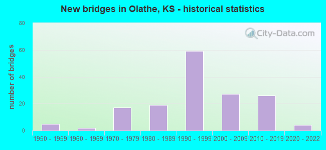
- New bridges - historical statistics
- 51950-1959
- 21960-1969
- 171970-1979
- 191980-1989
- 591990-1999
- 272000-2009
- 262010-2019
- 42020-2022
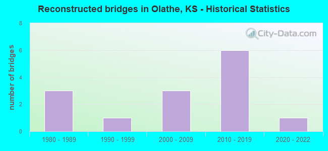
- Reconstructed bridges - Historical Statistics
- 31980-1989
- 11990-1999
- 32000-2009
- 62010-2019
- 12020-2022
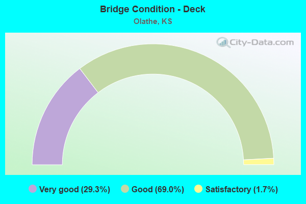
- Bridge Condition - Deck
- 29.3%Very good
- 69.0%Good
- 1.7%Satisfactory
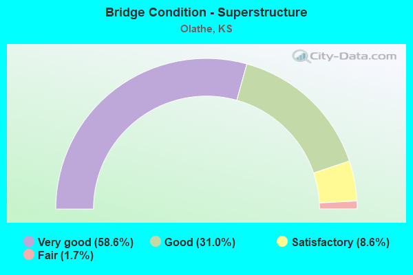
- Bridge Condition - Superstructure
- 58.6%Very good
- 31.0%Good
- 8.6%Satisfactory
- 1.7%Fair
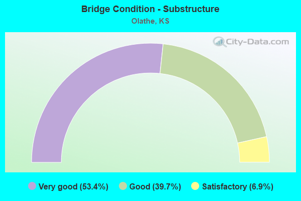
- Bridge Condition - Substructure
- 53.4%Very good
- 39.7%Good
- 6.9%Satisfactory
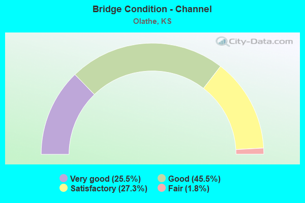
- Bridge Condition - Channel
- 25.5%Very good
- 45.5%Good
- 27.3%Satisfactory
- 1.8%Fair
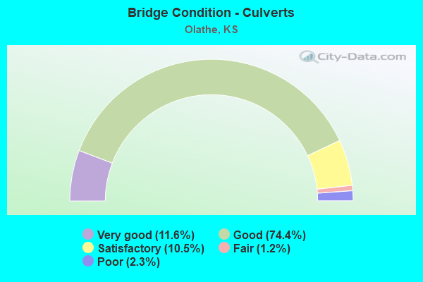
- Bridge Condition - Culverts
- 11.6%Very good
- 74.4%Good
- 10.5%Satisfactory
- 1.2%Fair
- 2.3%Poor
Find on map >> Show street view
Structure Number: 52120046000009, Location: 0.4 MI W OF MUR-LEN RD (Lat: 38.898092, Lng: -94.785472), Route carried "on" structure: City street , Year Built: 2007, Status: Open, Structure Length: 15.91m (52.20ft), Average Daily Traffic: 7,965 (year 2007), Truck Traffic: 5%, Average Future Daily Traffic: 15,600 (year 2043), Design Load: HL 93, Features Intersected: I-35, BNSF RR, ROGERS RD, Facility Carried by Structure: 127TH ST. EB #90
Minimum Vertical Clearance: 30.47m (99.97ft), Kilometerpoint: 0.000, Lanes on structure: 3, Lanes under structure: 8, Owner: City or Municipal Highway Agency, Approaching Roadway Width: 11.8m (38.7ft), Skew: 2 degrees, Material/Design: Prestressed concrete continuous, Design/Construction: Stringer/Multi-beam, Number Of Spans In Main Unit: 5, Length of Maximum Span: 33.0m (108.3ft), Curb or Sidewalk Widths: Left: 0.0m, Right: 1.6m (5.2ft), Curb-To-Curb Width: 11.9m (39.0ft), Out-to-Out Width: 15.3m (50.2ft)
Condition: Deck: Good, Superstructure: Very good, Substructure: Very good, Operating Rating: 39.2 metric tons, Method Used To Determine Operating Rating: Load and Resistance Factor Rating (LRFR) rating reported by rating factor(RF) method using HL-93 loadings, Inventory Rating: 30.5 metric tons, Method Used To Determine Inventory Rating: Load and Resistance Factor Rating (LRFR) rating reported by rating factor(RF) method using HL-93 loadings, Structural Evaluation: Better than present minimum criteria, Deck Geometry: High priority of corrective action, Underclear: Superior to present desirable criteria, Approach Roadway Alignment: Better than present minimum criteria, Designated Inspection Frequency: Every 24 months, Inspection Date: May 2021, Deck Structure Type: Concrete Cast-file-Place, Wearing Surface/Protective System: Deck Protection: Epoxy Coated Reinforcing
Find on map >> Show street view
Structure Number: 521200460000091, Location: 0.1 mi west of I-35 (Lat: 38.839964, Lng: -94.838019), Route carried "on" structure: City street , Year Built: 2009, Status: Open, Structure Length: 1.34m (4.40ft), Average Daily Traffic: 2,050 (year 2010), Truck Traffic: 30%, Average Future Daily Traffic: 2,460 (year 2043), Design Load: HS 20, Features Intersected: Cedar Creek, Facility Carried by Structure: 159th St. #91
Minimum Vertical Clearance: 30.47m (99.97ft), Kilometerpoint: 0.000, Lanes on structure: 2, Owner: City or Municipal Highway Agency, Approaching Roadway Width: 8.7m (28.5ft), Skew: 3 degrees, Material/Design: Concrete, Design/Construction: Culvert, Number Of Spans In Main Unit: 3, Length of Maximum Span: 4.2m (13.8ft)
Condition: Channel: Satisfactory, Culverts: Good, Operating Rating: 90.5 metric tons, Method Used To Determine Operating Rating: Load Factor (LF), Inventory Rating: 81.6 metric tons, Method Used To Determine Inventory Rating: Load Factor (LF), Structural Evaluation: Better than present minimum criteria, Waterway Adequacy: Equal to present desirable criteria, Approach Roadway Alignment: Equal to present desirable criteria, Designated Inspection Frequency: Every 24 months, Inspection Date: September 2021
Find on map >> Show street view
Structure Number: 521200460000096, Location: 0.15 MI N OF 163RD ST (Lat: 38.836272, Lng: -94.796547), Route carried "on" structure: City street , Year Built: 2000, Status: Open, Structure Length: 0.66m (2.17ft), Average Daily Traffic: 500 (year 2013), Truck Traffic: 5%, Average Future Daily Traffic: 600 (year 2043), Design Load: HS 20, Features Intersected: INDIAN CREEK, Facility Carried by Structure: AVALON ST. #96
Minimum Vertical Clearance: 30.47m (99.97ft), Kilometerpoint: 0.000, Lanes on structure: 2, Owner: City or Municipal Highway Agency, Approaching Roadway Width: 7.9m (25.9ft), Material/Design: Concrete, Design/Construction: Culvert, Number Of Spans In Main Unit: 2, Length of Maximum Span: 3.0m (9.8ft), Curb or Sidewalk Widths: Left: 0.0m, Right: 3.0m (9.8ft)
Condition: Channel: Good, Culverts: Good, Operating Rating: 32.7 metric tons, Method Used To Determine Operating Rating: Field evaluation and documented engineering judgment, Inventory Rating: 32.7 metric tons, Method Used To Determine Inventory Rating: Field evaluation and documented engineering judgment, Structural Evaluation: Better than present minimum criteria, Waterway Adequacy: Equal to present desirable criteria, Approach Roadway Alignment: Better than present minimum criteria, Designated Inspection Frequency: Every 24 months, Inspection Date: May 2021
Find on map >> Show street view
Structure Number: 521200460000097, Location: 0.24 MI E OF RIDGEVIEW RD (Lat: 38.840108, Lng: -94.792922), Route carried "on" structure: City street , Year Built: 2003, Status: Open, Structure Length: 0.82m (2.69ft), Average Daily Traffic: 10,300 (year 2007), Truck Traffic: 5%, Average Future Daily Traffic: 12,400 (year 2043), Design Load: HS 20, Features Intersected: INDIAN CREEK, Facility Carried by Structure: 159TH ST. #97
Minimum Vertical Clearance: 30.47m (99.97ft), Kilometerpoint: 0.000, Lanes on structure: 2, Owner: City or Municipal Highway Agency, Approaching Roadway Width: 11.5m (37.7ft), Skew: 2 degrees, Material/Design: Concrete, Design/Construction: Culvert, Number Of Spans In Main Unit: 3, Length of Maximum Span: 2.6m (8.5ft), Curb or Sidewalk Widths: Left: 2.4m (7.9ft), Right: 3.0m (9.8ft)
Condition: Channel: Good, Culverts: Good, Operating Rating: 32.7 metric tons, Method Used To Determine Operating Rating: Field evaluation and documented engineering judgment, Inventory Rating: 32.7 metric tons, Method Used To Determine Inventory Rating: Field evaluation and documented engineering judgment, Structural Evaluation: Better than present minimum criteria, Waterway Adequacy: Better than present minimum criteria, Approach Roadway Alignment: Equal to present desirable criteria, Designated Inspection Frequency: Every 24 months, Inspection Date: May 2021
Find on map >> Show street view
Structure Number: 521200460000098, Location: 0.12 MI W OF LACKMAN RD. (Lat: 38.825719, Lng: -94.763181), Route carried "on" structure: City street , Year Built: 2008, Status: Open, Structure Length: 0.89m (2.92ft), Average Daily Traffic: 1,500 (year 2013), Truck Traffic: 5%, Average Future Daily Traffic: 2,000 (year 2043), Design Load: HS 20, Features Intersected: COFFEE CREEK TRIBUTARY, Facility Carried by Structure: 167TH ST. #98
Minimum Vertical Clearance: 30.47m (99.97ft), Kilometerpoint: 0.000, Lanes on structure: 2, Owner: City or Municipal Highway Agency, Approaching Roadway Width: 7.9m (25.9ft), Skew: 4 degrees, Material/Design: Concrete, Design/Construction: Culvert, Number Of Spans In Main Unit: 2, Length of Maximum Span: 4.3m (14.1ft), Curb or Sidewalk Widths: Left: 0.0m, Right: 1.5m (4.9ft)
Condition: Channel: Good, Culverts: Good, Operating Rating: 90.6 metric tons, Method Used To Determine Operating Rating: Load Factor (LF), Inventory Rating: 57.6 metric tons, Method Used To Determine Inventory Rating: Load Factor (LF), Structural Evaluation: Better than present minimum criteria, Waterway Adequacy: Equal to present desirable criteria, Approach Roadway Alignment: Equal to present desirable criteria, Designated Inspection Frequency: Every 24 months, Inspection Date: May 2021
Find on map >> Show street view
Structure Number: 521200460000099, Location: 0.40 MI N. OF 151ST ST. (Lat: 38.860381, Lng: -94.770872), Route carried "on" structure: City street , Year Built: 2011, Status: Open, Structure Length: 0.79m (2.59ft), Average Daily Traffic: 4,700 (year 2005), Truck Traffic: 5%, Average Future Daily Traffic: 5,600 (year 2043), Design Load: HS 20, Features Intersected: INDIAN CREEK TRIBUTARY, Facility Carried by Structure: BROUGHAM DR. #99
Minimum Vertical Clearance: 30.47m (99.97ft), Kilometerpoint: 0.000, Lanes on structure: 2, Owner: City or Municipal Highway Agency, Approaching Roadway Width: 10.3m (33.8ft), Material/Design: Concrete, Design/Construction: Culvert, Number Of Spans In Main Unit: 2, Length of Maximum Span: 4.3m (14.1ft), Curb or Sidewalk Widths: Left: 1.2m (3.9ft), Right: 1.2m (3.9ft)
Condition: Channel: Very good, Culverts: Good, Operating Rating: 32.7 metric tons, Method Used To Determine Operating Rating: Field evaluation and documented engineering judgment, Inventory Rating: 32.7 metric tons, Method Used To Determine Inventory Rating: Field evaluation and documented engineering judgment, Structural Evaluation: Better than present minimum criteria, Waterway Adequacy: Equal to present desirable criteria, Approach Roadway Alignment: Equal to present desirable criteria, Designated Inspection Frequency: Every 24 months, Inspection Date: May 2021
Find on map >> Show street view
Structure Number: 5212004600001, Location: 0.18 MI W. OF US-169 HWY. (Lat: 38.835717, Lng: -94.819517), Route carried "on" structure: City street , Year Built: 1995, Status: Open, Structure Length: 0.80m (2.62ft), Average Daily Traffic: 500 (year 2013), Truck Traffic: 5%, Average Future Daily Traffic: 600 (year 2043), Design Load: HS 20, Features Intersected: CEDAR CREEK TRIBUTARY, Facility Carried by Structure: 161ST ST. #100
Minimum Vertical Clearance: 30.47m (99.97ft), Kilometerpoint: 0.000, Lanes on structure: 2, Owner: City or Municipal Highway Agency, Approaching Roadway Width: 10.3m (33.8ft), Material/Design: Steel, Design/Construction: Culvert, Number Of Spans In Main Unit: 3, Length of Maximum Span: 2.4m (7.9ft)
Condition: Channel: Very good, Culverts: Good, Operating Rating: 34.1 metric tons, Method Used To Determine Operating Rating: Load Factor (LF), Inventory Rating: 20.4 metric tons, Method Used To Determine Inventory Rating: Load Factor (LF), Structural Evaluation: Somewhat better than minimum adequacy, Waterway Adequacy: Equal to present desirable criteria, Approach Roadway Alignment: Equal to present desirable criteria, Designated Inspection Frequency: Every 24 months, Inspection Date: May 2021
Find on map >> Show street view
Structure Number: 521200460000102, Location: 0.08 MI S OF 103RD ST. (Lat: 38.940275, Lng: -94.877725), Route carried "on" structure: City street , Year Built: 1996, Status: Open, Structure Length: 0.75m (2.46ft), Average Daily Traffic: 100 (year 2013), Truck Traffic: 5%, Average Future Daily Traffic: 150 (year 2043), Design Load: HS 20, Features Intersected: CEDAR CREEK TRIBUTARY, Facility Carried by Structure: BLUESTEM PKWY #102
Minimum Vertical Clearance: 30.47m (99.97ft), Kilometerpoint: 0.000, Lanes on structure: 2, Owner: City or Municipal Highway Agency, Approaching Roadway Width: 10.5m (34.4ft), Skew: 3 degrees, Material/Design: Concrete, Design/Construction: Culvert, Number Of Spans In Main Unit: 2, Length of Maximum Span: 3.6m (11.8ft), Curb or Sidewalk Widths: Left: 1.2m (3.9ft), Right: 1.2m (3.9ft)
Condition: Channel: Good, Culverts: Good, Operating Rating: 32.7 metric tons, Method Used To Determine Operating Rating: Field evaluation and documented engineering judgment, Inventory Rating: 32.7 metric tons, Method Used To Determine Inventory Rating: Field evaluation and documented engineering judgment, Structural Evaluation: Better than present minimum criteria, Waterway Adequacy: Equal to present desirable criteria, Approach Roadway Alignment: Equal to present desirable criteria, Designated Inspection Frequency: Every 24 months, Inspection Date: May 2021
Find on map >> Show street view
Structure Number: 521200460000103, Location: 0.43S OF 119TH ST. (Lat: 38.906356, Lng: -94.834511), Route carried "on" structure: City street 4203, Year Built: 2014, Status: Open, Structure Length: 0.67m (2.20ft), Average Daily Traffic: 5,000 (year 2010), Truck Traffic: 2%, Average Future Daily Traffic: 6,000 (year 2043), Design Load: HS 20, Features Intersected: LITTLE CEDAR CREEK TRIB., Facility Carried by Structure: PARKER ST. #103
Minimum Vertical Clearance: 30.47m (99.97ft), Kilometerpoint: 0.000, Lanes on structure: 2, Owner: City or Municipal Highway Agency, Approaching Roadway Width: 6.8m (22.3ft), Material/Design: Concrete, Design/Construction: Culvert, Number Of Spans In Main Unit: 2, Length of Maximum Span: 3.1m (10.2ft)
Condition: Channel: Good, Culverts: Very good, Operating Rating: 90.6 metric tons, Method Used To Determine Operating Rating: Load Factor (LF), Inventory Rating: 84.0 metric tons, Method Used To Determine Inventory Rating: Load Factor (LF), Structural Evaluation: Equal to present desirable criteria, Waterway Adequacy: Equal to present desirable criteria, Approach Roadway Alignment: Equal to present desirable criteria, Designated Inspection Frequency: Every 24 months, Inspection Date: May 2021
Find on map >> Show street view
Structure Number: 521200460000104, Location: 0.5 MI N OF 151ST ST (Lat: 38.860700, Lng: -94.883811), Route carried "on" structure: City street 18961, Year Built: 2000, Status: Open, Structure Length: 0.76m (2.49ft), Average Daily Traffic: 1,000 (year 2016), Truck Traffic: 5%, Average Future Daily Traffic: 1,500 (year 2043), Features Intersected: UNNAMED STREAM, Facility Carried by Structure: S ST ANDREWS #104
Minimum Vertical Clearance: 30.47m (99.97ft), Kilometerpoint: 0.000, Lanes on structure: 2, Owner: City or Municipal Highway Agency, Approaching Roadway Width: 10.8m (35.4ft), Material/Design: Concrete, Design/Construction: Culvert, Number Of Spans In Main Unit: 3, Length of Maximum Span: 2.4m (7.9ft), Curb or Sidewalk Widths: Left: 1.2m (3.9ft), Right: 1.2m (3.9ft)
Condition: Channel: Very good, Culverts: Good, Operating Rating: 54.5 metric tons, Method Used To Determine Operating Rating: Load Factor (LF), Inventory Rating: 32.7 metric tons, Method Used To Determine Inventory Rating: Load Factor (LF), Structural Evaluation: Better than present minimum criteria, Waterway Adequacy: Equal to present desirable criteria, Approach Roadway Alignment: Better than present minimum criteria, Designated Inspection Frequency: Every 24 months, Inspection Date: May 2021
Find on map >> Show street view
Structure Number: 521200460000105, Location: 0.3 MI N OF 167TH ST (Lat: 38.829861, Lng: -94.829581), Route carried "on" structure: City street , Year Built: 2016, Status: Open, Structure Length: 1.14m (3.74ft), Average Daily Traffic: 1,000 (year 2016), Truck Traffic: 5%, Average Future Daily Traffic: 1,500 (year 2043), Design Load: HL 93, Features Intersected: CEDAR CREEK TRIB, Facility Carried by Structure: THEDEN ST #105
Minimum Vertical Clearance: 30.47m (99.97ft), Kilometerpoint: 0.000, Lanes on structure: 2, Owner: City or Municipal Highway Agency, Approaching Roadway Width: 10.5m (34.4ft), Material/Design: Concrete, Design/Construction: Culvert, Number Of Spans In Main Unit: 3, Length of Maximum Span: 3.7m (12.1ft), Curb or Sidewalk Widths: Left: 1.2m (3.9ft), Right: 0.0m
Condition: Channel: Very good, Culverts: Very good, Operating Rating: 55.3 metric tons, Method Used To Determine Operating Rating: Load Factor (LF), Inventory Rating: 33.1 metric tons, Method Used To Determine Inventory Rating: Load Factor (LF), Structural Evaluation: Equal to present desirable criteria, Waterway Adequacy: Equal to present desirable criteria, Approach Roadway Alignment: Equal to present desirable criteria, Designated Inspection Frequency: Every 24 months, Inspection Date: May 2021
Find on map >> Show street view
Structure Number: 52120046000011, Location: 1.0 MI W OF LONE ELM RD (Lat: 38.840039, Lng: -94.854339), Route carried "on" structure: City street 2730, Year Built: 2016, Status: Open, Structure Length: 22.49m (73.79ft), Average Daily Traffic: 1,900 (year 2016), Truck Traffic: 80%, Average Future Daily Traffic: 4,000 (year 2043), Design Load: HL 93, Features Intersected: BNSF RR & CEDAR CREEK, Facility Carried by Structure: W 159TH ST #110
Minimum Vertical Clearance: 30.47m (99.97ft), Kilometerpoint: 0.000, Lanes on structure: 2, Owner: City or Municipal Highway Agency, Approaching Roadway Width: 9.3m (30.5ft), Skew: 2 degrees, Material/Design: Prestressed concrete continuous, Design/Construction: Stringer/Multi-beam, Number Of Spans In Main Unit: 8, Length of Maximum Span: 30.5m (100.1ft), Curb or Sidewalk Widths: Left: 0.0m, Right: 3.0m (9.8ft), Curb-To-Curb Width: 9.4m (30.8ft), Out-to-Out Width: 13.4m (44.0ft)
Condition: Deck: Very good, Superstructure: Very good, Substructure: Very good, Channel: Very good, Operating Rating: 86.0 metric tons, Method Used To Determine Operating Rating: Load Factor (LF), Inventory Rating: 39.5 metric tons, Method Used To Determine Inventory Rating: Load Factor (LF), Structural Evaluation: Equal to present desirable criteria, Deck Geometry: Somewhat better than minimum adequacy, Underclear: Superior to present desirable criteria, Waterway Adequacy: Equal to present desirable criteria, Approach Roadway Alignment: Equal to present desirable criteria, Designated Inspection Frequency: Every 24 months, Inspection Date: May 2021, Deck Structure Type: Concrete Cast-file-Place, Wearing Surface/Protective System: Deck Protection: Epoxy Coated Reinforcing
Find on map >> Show street view
Structure Number: 521200460000111, Location: 1.6 MI WEST OF I-35 (Lat: 38.840050, Lng: -94.867461), Route carried "on" structure: City street 2730, Year Built: 2017, Status: Open, Structure Length: 0.89m (2.92ft), Average Daily Traffic: 1,900 (year 2017), Truck Traffic: 80%, Average Future Daily Traffic: 4,000 (year 2043), Design Load: HL 93, Features Intersected: CEDAR CREEK TRIBUTARY, Facility Carried by Structure: W 159TH ST. #111
Minimum Vertical Clearance: 30.47m (99.97ft), Kilometerpoint: 0.000, Lanes on structure: 2, Owner: City or Municipal Highway Agency, Approaching Roadway Width: 10.2m (33.5ft), Skew: 4 degrees, Material/Design: Concrete, Design/Construction: Culvert, Number Of Spans In Main Unit: 2, Length of Maximum Span: 4.3m (14.1ft)
Condition: Channel: Satisfactory, Culverts: Good, Operating Rating: 90.5 metric tons, Method Used To Determine Operating Rating: Load Factor (LF), Inventory Rating: 61.1 metric tons, Method Used To Determine Inventory Rating: Load Factor (LF), Structural Evaluation: Better than present minimum criteria, Waterway Adequacy: Equal to present desirable criteria, Approach Roadway Alignment: Equal to present desirable criteria, Designated Inspection Frequency: Every 24 months, Inspection Date: May 2021
Find on map >> Show street view
Structure Number: 52120046000B002, Location: 0.1W OF PFLUMN (Lat: 38.898244, Lng: -94.745433), Route carried "on" structure: City street 4220, Year Built: 2014, Status: Open, Structure Length: 0.87m (2.85ft), Average Daily Traffic: 9,000 (year 2010), Truck Traffic: 5%, Average Future Daily Traffic: 25,000 (year 2043), Design Load: HS 20, Features Intersected: INDIAN CREEK TRIB., Facility Carried by Structure: 127TH ST. #2
Minimum Vertical Clearance: 30.47m (99.97ft), Kilometerpoint: 0.000, Lanes on structure: 4, Owner: City or Municipal Highway Agency, Approaching Roadway Width: 16.2m (53.1ft), Skew: 23 degrees, Material/Design: Concrete, Design/Construction: Culvert, Number Of Spans In Main Unit: 2, Length of Maximum Span: 4.2m (13.8ft), Curb or Sidewalk Widths: Left: 1.8m (5.9ft), Right: 2.4m (7.9ft)
Condition: Channel: Good, Culverts: Good, Operating Rating: 90.5 metric tons, Method Used To Determine Operating Rating: Load Factor (LF), Inventory Rating: 90.5 metric tons, Method Used To Determine Inventory Rating: Load Factor (LF), Structural Evaluation: Better than present minimum criteria, Waterway Adequacy: Equal to present desirable criteria, Approach Roadway Alignment: Equal to present desirable criteria, Designated Inspection Frequency: Every 24 months, Inspection Date: May 2021
Find on map >> Show street view
Structure Number: 52120046000B007, Location: BTWN VAN MAR AND PARKWAY (Lat: 38.895000, Lng: -94.811131), Route carried "on" structure: City street 10942, Year Built: 2017, Status: Open, Structure Length: 2.51m (8.23ft), Average Daily Traffic: 600 (year 2017), Truck Traffic: 3%, Average Future Daily Traffic: 850 (year 2043), Design Load: HL 93, Features Intersected: MILL CREEK TRIB., Facility Carried by Structure: NORTHVIEW #7
Minimum Vertical Clearance: 30.47m (99.97ft), Kilometerpoint: 0.000, Lanes on structure: 2, Owner: City or Municipal Highway Agency, Approaching Roadway Width: 7.6m (24.9ft), Material/Design: Concrete continuous, Design/Construction: Slab, Number Of Spans In Main Unit: 3, Length of Maximum Span: 9.8m (32.2ft), Curb or Sidewalk Widths: Left: 2.6m (8.5ft), Right: 0.0m, Curb-To-Curb Width: 8.4m (27.6ft), Out-to-Out Width: 11.6m (38.1ft)
Condition: Deck: Very good, Superstructure: Very good, Substructure: Very good, Channel: Very good, Operating Rating: 96.1 metric tons, Method Used To Determine Operating Rating: Load Factor (LF), Inventory Rating: 57.4 metric tons, Method Used To Determine Inventory Rating: Load Factor (LF), Structural Evaluation: Equal to present desirable criteria, Deck Geometry: Somewhat better than minimum adequacy, Waterway Adequacy: Equal to present desirable criteria, Approach Roadway Alignment: Equal to present desirable criteria, Designated Inspection Frequency: Every 24 months, Inspection Date: May 2021, Deck Structure Type: Concrete Cast-file-Place, Wearing Surface/Protective System: Wearing Surface: Epoxy Overlay, Deck Protection: Epoxy Coated Reinforcing
Find on map >> Show street view
Structure Number: 52120046000B009, Location: 0.2W OF WOODLAND (Lat: 38.889403, Lng: -94.819336), Route carried "on" structure: City street 9711, Year Built: 2015, Status: Open, Structure Length: 1.20m (3.94ft), Average Daily Traffic: 300 (year 2011), Truck Traffic: 3%, Average Future Daily Traffic: 440 (year 2043), Design Load: HS 20, Features Intersected: MILL CREEK, Facility Carried by Structure: MULBERRY STREET #9
Minimum Vertical Clearance: 6.09m (19.98ft), Kilometerpoint: 0.000, Lanes on structure: 2, Owner: City or Municipal Highway Agency, Approaching Roadway Width: 8.5m (27.9ft), Material/Design: Concrete, Design/Construction: Culvert, Number Of Spans In Main Unit: 3, Length of Maximum Span: 3.7m (12.1ft), Curb or Sidewalk Widths: Left: 1.5m (4.9ft), Right: 0.0m
Condition: Channel: Good, Culverts: Good, Operating Rating: 98.0 metric tons, Method Used To Determine Operating Rating: Load Factor (LF), Inventory Rating: 58.8 metric tons, Method Used To Determine Inventory Rating: Load Factor (LF), Structural Evaluation: Better than present minimum criteria, Waterway Adequacy: Equal to present desirable criteria, Approach Roadway Alignment: Equal to present desirable criteria, Designated Inspection Frequency: Every 24 months, Inspection Date: May 2021
Find on map >> Show street view
Structure Number: 52120046000B015, Location: 0.4E OF PARKER (Lat: 38.880575, Lng: -94.826842), Route carried "on" structure: City street 7557, Year Built: 2021, Status: Open, Structure Length: 1.70m (5.58ft), Average Daily Traffic: 1,295 (year 2006), Truck Traffic: 3%, Average Future Daily Traffic: 1,860 (year 2043), Design Load: HL 93, Features Intersected: CEDAR CREEK TRIBUTARY, Facility Carried by Structure: LOULA STREET #15
Minimum Vertical Clearance: 5.48m (17.98ft), Kilometerpoint: 0.000, Lanes on structure: 2, Owner: City or Municipal Highway Agency, Approaching Roadway Width: 7.8m (25.6ft), Material/Design: Concrete, Design/Construction: Culvert, Number Of Spans In Main Unit: 6, Length of Maximum Span: 2.4m (7.9ft), Curb or Sidewalk Widths: Left: 0.0m, Right: 1.5m (4.9ft)
Condition: Channel: Good, Culverts: Very good, Operating Rating: 58.0 metric tons, Method Used To Determine Operating Rating: Load and Resistance Factor Rating (LRFR) rating reported by rating factor(RF) method using HL-93 loadings, Inventory Rating: 44.7 metric tons, Method Used To Determine Inventory Rating: Load and Resistance Factor Rating (LRFR) rating reported by rating factor(RF) method using HL-93 loadings, Structural Evaluation: Equal to present desirable criteria, Waterway Adequacy: Equal to present desirable criteria, Approach Roadway Alignment: Equal to present desirable criteria, Designated Inspection Frequency: Every 24 months, Inspection Date: May 2021, Wearing Surface/Protective System: Wearing Surface: Bituminous
Find on map >> Show street view
Structure Number: 52120046000B016, Location: 0.4E OF PARKER (Lat: 38.879061, Lng: -94.825856), Route carried "on" structure: City street 7565, Year Built: 2021, Status: Open, Structure Length: 1.39m (4.56ft), Average Daily Traffic: 600 (year 2011), Truck Traffic: 3%, Average Future Daily Traffic: 860 (year 2043), Design Load: HL 93, Features Intersected: LITTLE CEDAR CREEK TRIB., Facility Carried by Structure: CEDAR STREET #16
Minimum Vertical Clearance: 5.48m (17.98ft), Kilometerpoint: 0.000, Lanes on structure: 2, Owner: City or Municipal Highway Agency, Approaching Roadway Width: 7.3m (24.0ft), Material/Design: Concrete, Design/Construction: Culvert, Number Of Spans In Main Unit: 1, Length of Maximum Span: 2.4m (7.9ft), Curb or Sidewalk Widths: Left: 0.0m, Right: 1.5m (4.9ft)
Condition: Channel: Good, Culverts: Very good, Operating Rating: 48.3 metric tons, Method Used To Determine Operating Rating: Load and Resistance Factor Rating (LRFR) rating reported by rating factor(RF) method using HL-93 loadings, Inventory Rating: 37.3 metric tons, Method Used To Determine Inventory Rating: Load and Resistance Factor Rating (LRFR) rating reported by rating factor(RF) method using HL-93 loadings, Structural Evaluation: Equal to present desirable criteria, Waterway Adequacy: Equal to present desirable criteria, Approach Roadway Alignment: Equal to present desirable criteria, Designated Inspection Frequency: Every 24 months, Inspection Date: May 2021, Wearing Surface/Protective System: Wearing Surface: Bituminous
Find on map >> Show street view
Structure Number: 52120046000B018, Location: 0.5E OF PARKER (Lat: 38.877603, Lng: -94.825386), Route carried "on" structure: City street 7569, Year Built: 2021, Status: Open, Structure Length: 1.68m (5.51ft), Average Daily Traffic: 1,435 (year 2006), Truck Traffic: 3%, Average Future Daily Traffic: 2,060 (year 2043), Design Load: HL 93, Features Intersected: LITTLE CEDAR CREEK TRIB., Facility Carried by Structure: ELM STREET #18
Minimum Vertical Clearance: 5.48m (17.98ft), Kilometerpoint: 0.000, Lanes on structure: 2, Owner: City or Municipal Highway Agency, Approaching Roadway Width: 8.1m (26.6ft), Material/Design: Concrete, Design/Construction: Culvert, Number Of Spans In Main Unit: 6, Length of Maximum Span: 2.4m (7.9ft), Curb or Sidewalk Widths: Left: 0.0m, Right: 1.5m (4.9ft)
Condition: Channel: Good, Culverts: Very good, Operating Rating: 59.3 metric tons, Method Used To Determine Operating Rating: Load and Resistance Factor Rating (LRFR) rating reported by rating factor(RF) method using HL-93 loadings, Inventory Rating: 45.7 metric tons, Method Used To Determine Inventory Rating: Load and Resistance Factor Rating (LRFR) rating reported by rating factor(RF) method using HL-93 loadings, Structural Evaluation: Equal to present desirable criteria, Waterway Adequacy: Equal to present desirable criteria, Approach Roadway Alignment: Equal to present desirable criteria, Designated Inspection Frequency: Every 24 months, Inspection Date: May 2021, Wearing Surface/Protective System: Wearing Surface: Bituminous
Find on map >> Show street view
Structure Number: 52120046000B019, Location: 0.1E OF MUR-LEN (Lat: 38.875661, Lng: -94.778000), Route carried "on" structure: City street 11965, Year Built: 2019, Status: Open, Structure Length: 2.52m (8.27ft), Average Daily Traffic: 4,465 (year 2007), Truck Traffic: 3%, Average Future Daily Traffic: 6,430 (year 2043), Design Load: HL 93, Features Intersected: INDIAN CREEK TRIBUTARY, Facility Carried by Structure: 139TH. STREET #19
Minimum Vertical Clearance: 30.47m (99.97ft), Kilometerpoint: 0.000, Lanes on structure: 2, Owner: City or Municipal Highway Agency, Approaching Roadway Width: 10.6m (34.8ft), Material/Design: Concrete continuous, Design/Construction: Slab, Number Of Spans In Main Unit: 3, Length of Maximum Span: 9.8m (32.2ft), Curb or Sidewalk Widths: Left: 1.8m (5.9ft), Right: 1.8m (5.9ft), Curb-To-Curb Width: 10.7m (35.1ft), Out-to-Out Width: 15.5m (50.9ft)
Condition: Deck: Very good, Superstructure: Very good, Substructure: Very good, Channel: Very good, Operating Rating: 70.6 metric tons, Method Used To Determine Operating Rating: Load and Resistance Factor Rating (LRFR) rating reported by rating factor(RF) method using HL-93 loadings, Inventory Rating: 54.4 metric tons, Method Used To Determine Inventory Rating: Load and Resistance Factor Rating (LRFR) rating reported by rating factor(RF) method using HL-93 loadings, Structural Evaluation: Equal to present desirable criteria, Deck Geometry: Somewhat better than minimum adequacy, Waterway Adequacy: Equal to present desirable criteria, Approach Roadway Alignment: Equal to present desirable criteria, Designated Inspection Frequency: Every 24 months, Inspection Date: May 2021, Deck Structure Type: Concrete Cast-file-Place, Wearing Surface/Protective System: Wearing Surface: Epoxy Overlay, Deck Protection: Epoxy Coated Reinforcing
Find on map >> Show street view
Structure Number: 52120046000B028, Location: 0.4 MI W OF MUR-LEN RD (Lat: 38.864689, Lng: -94.787089), Route carried "on" structure: City street 10847, Year Built: 2016, Status: Open, Structure Length: 2.51m (8.23ft), Average Daily Traffic: 3,335 (year 2017), Truck Traffic: 3%, Average Future Daily Traffic: 4,000 (year 2043), Design Load: HL 93, Features Intersected: INDIAN CREEK, Facility Carried by Structure: E SHERIDAN BR #28
Minimum Vertical Clearance: 30.47m (99.97ft), Kilometerpoint: 0.000, Lanes on structure: 2, Owner: City or Municipal Highway Agency, Approaching Roadway Width: 8.1m (26.6ft), Material/Design: Concrete continuous, Design/Construction: Slab, Number Of Spans In Main Unit: 3, Length of Maximum Span: 9.8m (32.2ft), Curb or Sidewalk Widths: Left: 2.7m (8.9ft), Right: 0.0m, Curb-To-Curb Width: 8.3m (27.2ft), Out-to-Out Width: 11.6m (38.1ft)
Condition: Deck: Very good, Superstructure: Very good, Substructure: Very good, Channel: Very good, Operating Rating: 94.3 metric tons, Method Used To Determine Operating Rating: Load Factor (LF), Inventory Rating: 56.4 metric tons, Method Used To Determine Inventory Rating: Load Factor (LF), Structural Evaluation: Equal to present desirable criteria, Deck Geometry: High priority of corrective action, Waterway Adequacy: Equal to present desirable criteria, Approach Roadway Alignment: Equal to present desirable criteria, Designated Inspection Frequency: Every 24 months, Inspection Date: May 2021, Deck Structure Type: Concrete Cast-file-Place, Wearing Surface/Protective System: Wearing Surface: Epoxy Overlay, Deck Protection: Epoxy Coated Reinforcing
Find on map >> Show street view
Structure Number: 52120046000B05, Location: 0.1W OF LINDENWOOD (Lat: 38.850664, Lng: -94.790494), Route carried "on" structure: City street 8051, Year Built: 2014, Status: Open, Structure Length: 1.75m (5.74ft), Average Daily Traffic: 1,500 (year 2011), Truck Traffic: 2%, Average Future Daily Traffic: 2,000 (year 2043), Design Load: HL 93, Features Intersected: INDIAN CREEK, Facility Carried by Structure: 153RD TERR. #50
Minimum Vertical Clearance: 30.47m (99.97ft), Kilometerpoint: 0.000, Lanes on structure: 2, Owner: City or Municipal Highway Agency, Approaching Roadway Width: 8.0m (26.2ft), Skew: 1 degrees, Material/Design: Concrete, Design/Construction: Culvert, Number Of Spans In Main Unit: 5, Length of Maximum Span: 3.1m (10.2ft), Curb or Sidewalk Widths: Left: 0.0m, Right: 1.2m (3.9ft)
Condition: Channel: Very good, Culverts: Good, Operating Rating: 62.9 metric tons, Method Used To Determine Operating Rating: Load and Resistance Factor Rating (LRFR) rating reported by rating factor(RF) method using HL-93 loadings, Inventory Rating: 48.6 metric tons, Method Used To Determine Inventory Rating: Load and Resistance Factor Rating (LRFR) rating reported by rating factor(RF) method using HL-93 loadings, Structural Evaluation: Better than present minimum criteria, Waterway Adequacy: Equal to present desirable criteria, Approach Roadway Alignment: Equal to present desirable criteria, Designated Inspection Frequency: Every 24 months, Inspection Date: May 2021
Find on map >> Show street view
Structure Number: 999900700462991, Location: 2.27 MI N K7/SANTA FE JCT (Lat: 38.912500, Lng: -94.851944), Route carried "on" structure: State highway 7, Year Built: 1995, Status: Open, Structure Length: 6.47m (21.23ft), Average Daily Traffic: 10,556 (year 2020), Truck Traffic: 8%, Average Future Daily Traffic: 17,297 (year 2041), Design Load: HS 25 or greater, Features Intersected: 119TH STREET
Minimum Vertical Clearance: 30.47m (99.97ft), Kilometerpoint: 21.988, Lanes on structure: 2, Lanes under structure: 4, Base Highway Network: Yes, Owner: State Highway Agency, Approaching Roadway Width: 12.2m (40.0ft), Skew: 1 degrees, Material/Design: Steel continuous, Design/Construction: Stringer/Multi-beam, Number Of Spans In Main Unit: 4, Length of Maximum Span: 19.5m (64.0ft), Curb-To-Curb Width: 12.2m (40.0ft), Out-to-Out Width: 13.0m (42.7ft)
Condition: Deck: Good, Superstructure: Very good, Substructure: Good, Operating Rating: 74.8 metric tons, Method Used To Determine Operating Rating: Load Factor (LF), Inventory Rating: 44.7 metric tons, Method Used To Determine Inventory Rating: Load Factor (LF), Structural Evaluation: Better than present minimum criteria, Deck Geometry: Better than present minimum criteria, Underclear: Superior to present desirable criteria, Approach Roadway Alignment: Equal to present desirable criteria, Length Of Structure Improvement: 21.23m (69.65ft), Designated Inspection Frequency: Every 24 months, Inspection Date: May 2020, Wearing Surface/Protective System: Wearing Surface: Low Slump Concrete, Deck Protection: Epoxy Coated Reinforcing
Find on map >> Show street view
Structure Number: 999900700463001, Location: 2.28 MI N K7/SANTA FE JCT (Lat: 38.912500, Lng: -94.852222), Route carried "on" structure: State highway 7, Year Built: 1995, Status: Open, Structure Length: 6.47m (21.23ft), Average Daily Traffic: 10,556 (year 2020), Truck Traffic: 8%, Average Future Daily Traffic: 17,297 (year 2041), Design Load: HS 25 or greater, Features Intersected: 119TH STREET
Minimum Vertical Clearance: 30.47m (99.97ft), Kilometerpoint: 22.011, Lanes on structure: 2, Lanes under structure: 4, Base Highway Network: Yes, Owner: State Highway Agency, Approaching Roadway Width: 12.2m (40.0ft), Skew: 1 degrees, Material/Design: Steel continuous, Design/Construction: Stringer/Multi-beam, Number Of Spans In Main Unit: 4, Length of Maximum Span: 19.5m (64.0ft), Curb-To-Curb Width: 12.2m (40.0ft), Out-to-Out Width: 13.0m (42.7ft)
Condition: Deck: Good, Superstructure: Very good, Substructure: Good, Operating Rating: 74.8 metric tons, Method Used To Determine Operating Rating: Load Factor (LF), Inventory Rating: 44.7 metric tons, Method Used To Determine Inventory Rating: Load Factor (LF), Structural Evaluation: Better than present minimum criteria, Deck Geometry: Better than present minimum criteria, Underclear: Superior to present desirable criteria, Approach Roadway Alignment: Equal to present desirable criteria, Length Of Structure Improvement: 21.23m (69.65ft), Designated Inspection Frequency: Every 24 months, Inspection Date: May 2020, Wearing Surface/Protective System: Wearing Surface: Low Slump Concrete, Deck Protection: Epoxy Coated Reinforcing
Find on map >> Show street view
Structure Number: 999900700463011, Location: 3.29 MI N K7/SANTA FE JCT (Lat: 38.927222, Lng: -94.852500), Route carried "on" structure: City street 4210, Year Built: 1995, Status: Open, Structure Length: 8.92m (29.27ft), Average Daily Traffic: 3,234 (year 2020), Truck Traffic: 7%, Average Future Daily Traffic: 4,806 (year 2041), Design Load: HS 25 or greater, Features Intersected: K-7 HWY, Facility Carried by Structure: College Blvd
Minimum Vertical Clearance: 30.47m (99.97ft), Kilometerpoint: 2.900, Lanes on structure: 4, Lanes under structure: 4, Owner: State Highway Agency, Approaching Roadway Width: 23.2m (76.1ft), Material/Design: Steel continuous, Design/Construction: Stringer/Multi-beam, Number Of Spans In Main Unit: 4, Length of Maximum Span: 27.4m (89.9ft), Curb or Sidewalk Widths: Left: 1.5m (4.9ft), Right: 0.0m, Curb-To-Curb Width: 23.2m (76.1ft), Out-to-Out Width: 25.8m (84.6ft)
Condition: Deck: Good, Superstructure: Very good, Substructure: Good, Operating Rating: 68.0 metric tons, Method Used To Determine Operating Rating: Load Factor (LF), Inventory Rating: 40.8 metric tons, Method Used To Determine Inventory Rating: Load Factor (LF), Structural Evaluation: Better than present minimum criteria, Deck Geometry: Superior to present desirable criteria, Underclear: Superior to present desirable criteria, Approach Roadway Alignment: Somewhat better than minimum adequacy, Length Of Structure Improvement: 29.25m (95.96ft), Designated Inspection Frequency: Every 24 months, Inspection Date: May 2020, Wearing Surface/Protective System: Wearing Surface: Low Slump Concrete, Deck Protection: Epoxy Coated Reinforcing
Find on map >> Show street view
Structure Number: 999900700463221, Location: 1.64 MI N K7/SANTA FE JCT (Lat: 38.905000, Lng: -94.845833), Route carried "on" structure: State highway 7, Year Built: 1995, Status: Open, Structure Length: 0.63m (2.07ft), Average Daily Traffic: 10,556 (year 2020), Truck Traffic: 8%, Average Future Daily Traffic: 17,297 (year 2041), Design Load: HS 20, Features Intersected: LITTLE CEDAR CR DRAIN
Minimum Vertical Clearance: 30.47m (99.97ft), Kilometerpoint: 20.984, Lanes on structure: 4, Base Highway Network: Yes, Owner: State Highway Agency, Approaching Roadway Width: 24.4m (80.1ft), Skew: 23 degrees, Material/Design: Concrete, Design/Construction: Culvert, Number Of Spans In Main Unit: 2, Length of Maximum Span: 2.4m (7.9ft), Curb-To-Curb Width: 24.4m (80.1ft), Out-to-Out Width: 148.0m (485.6ft)
Condition: Channel: Good, Culverts: Good, Operating Rating: 89.8 metric tons, Method Used To Determine Operating Rating: Load Factor (LF), Inventory Rating: 89.8 metric tons, Method Used To Determine Inventory Rating: Load Factor (LF), Structural Evaluation: Better than present minimum criteria, Deck Geometry: Superior to present desirable criteria, Waterway Adequacy: Better than present minimum criteria, Approach Roadway Alignment: Equal to present desirable criteria, Length Of Structure Improvement: 2.06m (6.76ft), Designated Inspection Frequency: Every 24 months, Inspection Date: May 2020, Deck Structure Type: Concrete Cast-file-Place, Wearing Surface/Protective System: Wearing Surface: Monolithic Concrete
Find on map >> Show street view
Structure Number: 999900700463231, Location: JCT K7/SANTA FE (Lat: 38.883889, Lng: -94.834444), Route carried "on" structure: State highway 7, Year Built: 1995, Status: Open, Structure Length: 0.67m (2.20ft), Average Daily Traffic: 21,113 (year 2020), Truck Traffic: 8%, Average Future Daily Traffic: 34,596 (year 2041), Design Load: HS 20, Features Intersected: DRAINAGE CHANNEL
Minimum Vertical Clearance: 30.47m (99.97ft), Kilometerpoint: 18.361, Lanes on structure: 8, Base Highway Network: Yes, Owner: State Highway Agency, Approaching Roadway Width: 16.2m (53.1ft), Skew: 21 degrees, Material/Design: Concrete, Design/Construction: Culvert, Number Of Spans In Main Unit: 2, Length of Maximum Span: 3.0m (9.8ft), Curb or Sidewalk Widths: Left: 1.5m (4.9ft), Right: 0.0m, Curb-To-Curb Width: 26.5m (86.9ft), Out-to-Out Width: 222.4m (729.7ft)
Condition: Channel: Good, Culverts: Fair, Operating Rating: 89.8 metric tons, Method Used To Determine Operating Rating: Load Factor (LF), Inventory Rating: 89.8 metric tons, Method Used To Determine Inventory Rating: Load Factor (LF), Structural Evaluation: Somewhat better than minimum adequacy, Deck Geometry: High priority of replacement, Waterway Adequacy: Equal to present desirable criteria, Approach Roadway Alignment: Equal to present desirable criteria, Length Of Structure Improvement: 2.20m (7.22ft), Designated Inspection Frequency: Every 24 months, Inspection Date: May 2020, Deck Structure Type: Concrete Cast-file-Place, Wearing Surface/Protective System: Wearing Surface: Bituminous
Find on map >> Show street view
Structure Number: 999900700463321, Location: 0.59 MI E WJCT K-7 (Lat: 38.867500, Lng: -94.823611), Route carried "on" structure: State highway 7, Year Built: 2002, Status: Open, Structure Length: 7.74m (25.39ft), Average Daily Traffic: 16,466 (year 2020), Truck Traffic: 10%, Average Future Daily Traffic: 26,981 (year 2041), Design Load: HS 25 or greater, Features Intersected: BNSF RAILROAD
Minimum Vertical Clearance: 30.47m (99.97ft), Kilometerpoint: 15.601, Lanes on structure: 4, Base Highway Network: Yes, Owner: State Highway Agency, Approaching Roadway Width: 16.0m (52.5ft), Skew: 3 degrees, Material/Design: Steel continuous, Design/Construction: Stringer/Multi-beam, Number Of Spans In Main Unit: 3, Length of Maximum Span: 32.5m (106.6ft), Curb-To-Curb Width: 16.0m (52.5ft), Out-to-Out Width: 16.8m (55.1ft)
Condition: Deck: Good, Superstructure: Very good, Substructure: Good, Operating Rating: 89.8 metric tons, Method Used To Determine Operating Rating: Load Factor (LF), Inventory Rating: 61.3 metric tons, Method Used To Determine Inventory Rating: Load Factor (LF), Structural Evaluation: Better than present minimum criteria, Deck Geometry: Meets minimum limits, Underclear: Meets minimum limits, Approach Roadway Alignment: Meets minimum limits, Length Of Structure Improvement: 25.40m (83.33ft), Designated Inspection Frequency: Every 24 months, Inspection Date: May 2020, Wearing Surface/Protective System: Wearing Surface: Low Slump Concrete, Deck Protection: Epoxy Coated Reinforcing
Find on map >> Show street view
Structure Number: 999901000461861, Location: 9.23MI E DGLS CO LN (Lat: 38.950556, Lng: -94.905000), Route carried "on" structure: State highway 10, Year Built: 1974, Status: Open, Structure Length: 3.73m (12.24ft), Average Daily Traffic: 18,392 (year 2020), Truck Traffic: 5%, Average Future Daily Traffic: 30,137 (year 2041), Design Load: HS 20, Features Intersected: CEDAR CREEK ROAD
Minimum Vertical Clearance: 30.47m (99.97ft), Kilometerpoint: 14.196, Lanes on structure: 2, Lanes under structure: 2, Base Highway Network: Yes, Owner: State Highway Agency, Approaching Roadway Width: 12.2m (40.0ft), Material/Design: Concrete continuous, Design/Construction: Slab, Number Of Spans In Main Unit: 3, Length of Maximum Span: 14.6m (47.9ft), Curb-To-Curb Width: 12.2m (40.0ft), Out-to-Out Width: 12.8m (42.0ft)
Condition: Deck: Good, Superstructure: Good, Substructure: Good, Operating Rating: 59.9 metric tons, Method Used To Determine Operating Rating: Load Factor (LF), Inventory Rating: 36.3 metric tons, Method Used To Determine Inventory Rating: Load Factor (LF), Structural Evaluation: Better than present minimum criteria, Deck Geometry: Better than present minimum criteria, Underclear: Better than present minimum criteria, Approach Roadway Alignment: Equal to present desirable criteria, Length Of Structure Improvement: 12.25m (40.19ft), Designated Inspection Frequency: Every 24 months, Inspection Date: May 2020, Deck Structure Type: Concrete Cast-file-Place, Wearing Surface/Protective System: Wearing Surface: Low Slump Concrete
Find on map >> Show street view
Structure Number: 999901000461871, Location: 9.24MI E DGLS CO LN (Lat: 38.950278, Lng: -94.905000), Route carried "on" structure: State highway 10, Year Built: 1974, Status: Open, Structure Length: 3.73m (12.24ft), Average Daily Traffic: 18,392 (year 2020), Truck Traffic: 5%, Average Future Daily Traffic: 30,137 (year 2041), Design Load: HS 20, Features Intersected: CEDAR CREEK ROAD
Minimum Vertical Clearance: 30.47m (99.97ft), Kilometerpoint: 14.178, Lanes on structure: 2, Lanes under structure: 2, Base Highway Network: Yes, Owner: State Highway Agency, Approaching Roadway Width: 12.2m (40.0ft), Material/Design: Concrete continuous, Design/Construction: Slab, Number Of Spans In Main Unit: 3, Length of Maximum Span: 14.6m (47.9ft), Curb-To-Curb Width: 12.2m (40.0ft), Out-to-Out Width: 12.8m (42.0ft)
Condition: Deck: Satisfactory, Superstructure: Good, Substructure: Good, Operating Rating: 61.7 metric tons, Method Used To Determine Operating Rating: Load Factor (LF), Inventory Rating: 37.2 metric tons, Method Used To Determine Inventory Rating: Load Factor (LF), Structural Evaluation: Better than present minimum criteria, Deck Geometry: Better than present minimum criteria, Underclear: Equal to present desirable criteria, Approach Roadway Alignment: Equal to present desirable criteria, Length Of Structure Improvement: 12.25m (40.19ft), Designated Inspection Frequency: Every 24 months, Inspection Date: May 2020, Deck Structure Type: Concrete Cast-file-Place, Wearing Surface/Protective System: Wearing Surface: Monolithic Concrete
Find on map >> Show street view
Structure Number: 999901000461891, Location: 9.95MI E DGLS CO LN (Lat: 38.947500, Lng: -94.885556), Route carried "on" structure: State highway 10, Year Built: 1974, Status: Open, Structure Length: 5.26m (17.26ft), Average Daily Traffic: 18,392 (year 2020), Truck Traffic: 5%, Average Future Daily Traffic: 30,137 (year 2041), Design Load: HS 20, Features Intersected: CEDAR CREEK PKWY
Minimum Vertical Clearance: 30.47m (99.97ft), Kilometerpoint: 15.981, Lanes on structure: 2, Lanes under structure: 2, Base Highway Network: Yes, Owner: State Highway Agency, Approaching Roadway Width: 12.2m (40.0ft), Material/Design: Concrete continuous, Design/Construction: Box Beam or Girders - Multiple, Number Of Spans In Main Unit: 3, Length of Maximum Span: 20.7m (67.9ft), Curb-To-Curb Width: 12.2m (40.0ft), Out-to-Out Width: 12.8m (42.0ft)
Condition: Deck: Good, Superstructure: Satisfactory, Substructure: Satisfactory, Operating Rating: 80.2 metric tons, Method Used To Determine Operating Rating: Load Factor (LF), Inventory Rating: 48.1 metric tons, Method Used To Determine Inventory Rating: Load Factor (LF), Structural Evaluation: Equal to present minimum criteria, Deck Geometry: Better than present minimum criteria, Underclear: Equal to present minimum criteria, Approach Roadway Alignment: Equal to present desirable criteria, Length Of Structure Improvement: 17.24m (56.56ft), Designated Inspection Frequency: Every 24 months, Inspection Date: May 2020, Deck Structure Type: Concrete Cast-file-Place, Wearing Surface/Protective System: Wearing Surface: Low Slump Concrete
Find on map >> Show street view
Structure Number: 999901000461901, Location: 9.94MI E DGLS CO LN (Lat: 38.947500, Lng: -94.885556), Route carried "on" structure: State highway 10, Year Built: 1974, Status: Open, Structure Length: 5.26m (17.26ft), Average Daily Traffic: 18,392 (year 2020), Truck Traffic: 5%, Average Future Daily Traffic: 30,137 (year 2041), Design Load: HS 20, Features Intersected: CEDAR CREEK PKWY
Minimum Vertical Clearance: 30.47m (99.97ft), Kilometerpoint: 15.976, Lanes on structure: 2, Lanes under structure: 2, Base Highway Network: Yes, Owner: State Highway Agency, Approaching Roadway Width: 12.2m (40.0ft), Material/Design: Concrete continuous, Design/Construction: Box Beam or Girders - Multiple, Number Of Spans In Main Unit: 3, Length of Maximum Span: 20.7m (67.9ft), Curb-To-Curb Width: 12.2m (40.0ft), Out-to-Out Width: 12.8m (42.0ft)
Condition: Deck: Good, Superstructure: Satisfactory, Substructure: Satisfactory, Operating Rating: 80.2 metric tons, Method Used To Determine Operating Rating: Load Factor (LF), Inventory Rating: 48.1 metric tons, Method Used To Determine Inventory Rating: Load Factor (LF), Structural Evaluation: Equal to present minimum criteria, Deck Geometry: Better than present minimum criteria, Underclear: Better than present minimum criteria, Approach Roadway Alignment: Equal to present desirable criteria, Length Of Structure Improvement: 17.25m (56.59ft), Designated Inspection Frequency: Every 24 months, Inspection Date: May 2020, Deck Structure Type: Concrete Cast-file-Place, Wearing Surface/Protective System: Wearing Surface: Low Slump Concrete
Find on map >> Show street view
Structure Number: 999901000464251, Location: 2.98 MI E OF K-7 (Lat: 38.941389, Lng: -94.797500), Route carried "on" structure: City street 4241, Year Built: 2014, Status: Open, Structure Length: 6.29m (20.64ft), Average Daily Traffic: 5,546 (year 2020), Truck Traffic: 7%, Average Future Daily Traffic: 8,912 (year 2041), Design Load: HL 93, Features Intersected: K-10 HWY, Facility Carried by Structure: PED PASS & RIDGV
Minimum Vertical Clearance: 30.47m (99.97ft), Kilometerpoint: 5.441, Lanes on structure: 4, Lanes under structure: 4, Owner: State Highway Agency, Approaching Roadway Width: 18.4m (60.4ft), Skew: 20 degrees, Material/Design: Prestressed concrete continuous, Design/Construction: Stringer/Multi-beam, Number Of Spans In Main Unit: 2, Length of Maximum Span: 31.7m (104.0ft), Curb-To-Curb Width: 22.7m (74.5ft), Out-to-Out Width: 23.5m (77.1ft)
Condition: Deck: Very good, Superstructure: Very good, Substructure: Very good, Operating Rating: 61.2 metric tons, Method Used To Determine Operating Rating: Load and Resistance Factor Rating (LRFR) rating reported by rating factor(RF) method using HL-93 loadings, Inventory Rating: 41.5 metric tons, Method Used To Determine Inventory Rating: Load and Resistance Factor Rating (LRFR) rating reported by rating factor(RF) method using HL-93 loadings, Structural Evaluation: Equal to present desirable criteria, Deck Geometry: Superior to present desirable criteria, Underclear: High priority of corrective action, Approach Roadway Alignment: Somewhat better than minimum adequacy, Length Of Structure Improvement: 20.65m (67.75ft), Designated Inspection Frequency: Every 24 months, Inspection Date: May 2020, Wearing Surface/Protective System: Wearing Surface: Epoxy Overlay, Deck Protection: Epoxy Coated Reinforcing
Find on map >> Show street view
Structure Number: 999903500460141, Location: 10.55 MI NE MI COLN (Lat: 38.825278, Lng: -94.858611), Route carried "on" structure: County highway 2734, Year Built: 1959, Status: Open, Structure Length: 7.29m (23.92ft), Average Daily Traffic: 5,404 (year 2020), Truck Traffic: 15%, Average Future Daily Traffic: 5,404 (year 2041), Design Load: H 15, Features Intersected: I35 HWY, WL-EL, Facility Carried by Structure: 167TH ST
Minimum Vertical Clearance: 30.47m (99.97ft), Kilometerpoint: 1.170, Lanes on structure: 2, Lanes under structure: 4, Owner: State Highway Agency, Approaching Roadway Width: 7.4m (24.3ft), Material/Design: Concrete continuous, Design/Construction: Box Beam or Girders - Multiple, Number Of Spans In Main Unit: 4, Length of Maximum Span: 20.7m (67.9ft), Curb-To-Curb Width: 7.3m (24.0ft), Out-to-Out Width: 8.9m (29.2ft)
Condition: Deck: Good, Superstructure: Good, Substructure: Good, Operating Rating: 59.4 metric tons, Method Used To Determine Operating Rating: Load Factor (LF), Inventory Rating: 35.6 metric tons, Method Used To Determine Inventory Rating: Load Factor (LF), Structural Evaluation: Better than present minimum criteria, Deck Geometry: High priority of replacement, Underclear: Somewhat better than minimum adequacy, Approach Roadway Alignment: High priority of corrective action, Length Of Structure Improvement: 23.90m (78.41ft), Designated Inspection Frequency: Every 24 months, Inspection Date: May 2020, Deck Structure Type: Concrete Cast-file-Place, Wearing Surface/Protective System: Wearing Surface: Monolithic Concrete
Find on map >> Show street view
Structure Number: 999903500460151, Location: 11.94 MI NE MI COLN (Lat: 38.838333, Lng: -94.838889), Route carried "on" structure: Interstate 35, Year Built: 1958, Year Reconstructed: 2010, Status: Open, Structure Length: 1.31m (4.30ft), Average Daily Traffic: 25,588 (year 2020), Truck Traffic: 23%, Average Future Daily Traffic: 42,755 (year 2041), Design Load: HS 25 or greater, Features Intersected: OLATHE LAKE DRAINAGE
Minimum Vertical Clearance: 30.47m (99.97ft), Kilometerpoint: 19.235, Lanes on structure: 6, Base Highway Network: Yes, Owner: State Highway Agency, Approaching Roadway Width: 24.4m (80.1ft), Skew: 30 degrees, Material/Design: Concrete, Design/Construction: Culvert, Number Of Spans In Main Unit: 2, Number Of Approach Spans: 2, Length of Maximum Span: 3.1m (10.2ft), Curb-To-Curb Width: 24.4m (80.1ft), Out-to-Out Width: 65.5m (214.9ft)
Condition: Channel: Very good, Culverts: Good, Operating Rating: 40.7 metric tons, Method Used To Determine Operating Rating: Load Factor (LF), Inventory Rating: 24.4 metric tons, Method Used To Determine Inventory Rating: Load Factor (LF), Structural Evaluation: Equal to present minimum criteria, Deck Geometry: Meets minimum limits, Waterway Adequacy: Equal to present desirable criteria, Approach Roadway Alignment: Equal to present desirable criteria, Length Of Structure Improvement: 4.48m (14.70ft), Designated Inspection Frequency: Every 24 months, Inspection Date: May 2020, Deck Structure Type: Concrete Cast-file-Place
Find on map >> Show street view
Structure Number: 999903500460181, Location: 12.69 MI NE MI COLN (Lat: 38.845000, Lng: -94.828056), Route carried "on" structure: Interstate 35, Year Built: 1959, Year Reconstructed: 2010, Status: Open, Structure Length: 1.28m (4.20ft), Average Daily Traffic: 25,588 (year 2020), Truck Traffic: 27%, Average Future Daily Traffic: 42,755 (year 2041), Design Load: HS 25 or greater, Features Intersected: OLATHE LAKE DRAINAGE
Minimum Vertical Clearance: 30.47m (99.97ft), Kilometerpoint: 20.431, Lanes on structure: 8, Base Highway Network: Yes, Owner: State Highway Agency, Approaching Roadway Width: 24.4m (80.1ft), Skew: 33 degrees, Material/Design: Concrete, Design/Construction: Culvert, Number Of Spans In Main Unit: 2, Number Of Approach Spans: 1, Length of Maximum Span: 4.3m (14.1ft), Curb-To-Curb Width: 85.0m (278.9ft), Out-to-Out Width: 103.6m (339.9ft)
Condition: Channel: Good, Culverts: Good, Operating Rating: 55.8 metric tons, Method Used To Determine Operating Rating: Load Factor (LF), Inventory Rating: 33.4 metric tons, Method Used To Determine Inventory Rating: Load Factor (LF), Structural Evaluation: Better than present minimum criteria, Deck Geometry: Superior to present desirable criteria, Waterway Adequacy: Equal to present desirable criteria, Approach Roadway Alignment: Equal to present desirable criteria, Length Of Structure Improvement: 4.39m (14.40ft), Designated Inspection Frequency: Every 24 months, Inspection Date: May 2020, Deck Structure Type: Concrete Cast-file-Place, Wearing Surface/Protective System: Wearing Surface: Monolithic Concrete
Find on map >> Show street view
Structure Number: 999903500462871, Location: 2.32 MI NW OLD169 & 150 (Lat: 38.912500, Lng: -94.771111), Route carried "on" structure: City street 4211, Year Built: 1992, Status: Open, Structure Length: 10.52m (34.51ft), Average Daily Traffic: 12,808 (year 2020), Truck Traffic: 6%, Average Future Daily Traffic: 38,064 (year 2041), Design Load: HS 20+Mod, Features Intersected: I-35 HWY, WL-EL, Facility Carried by Structure: ROAD(119TH ST) EB
Minimum Vertical Clearance: 30.47m (99.97ft), Kilometerpoint: 7.591, Lanes on structure: 4, Lanes under structure: 6, Owner: State Highway Agency, Approaching Roadway Width: 12.2m (40.0ft), Skew: 25 degrees, Material/Design: Steel continuous, Design/Construction: Stringer/Multi-beam, Number Of Spans In Main Unit: 4, Length of Maximum Span: 34.1m (111.9ft), Curb-To-Curb Width: 15.6m (51.2ft), Out-to-Out Width: 16.8m (55.1ft)
Condition: Deck: Good, Superstructure: Good, Substructure: Good, Operating Rating: 58.1 metric tons, Method Used To Determine Operating Rating: Load Factor (LF), Inventory Rating: 34.5 metric tons, Method Used To Determine Inventory Rating: Load Factor (LF), Structural Evaluation: Better than present minimum criteria, Deck Geometry: Meets minimum limits, Underclear: Equal to present minimum criteria, Approach Roadway Alignment: Better than present minimum criteria, Length Of Structure Improvement: 34.50m (113.19ft), Designated Inspection Frequency: Every 24 months, Inspection Date: May 2020, Wearing Surface/Protective System: Wearing Surface: Low Slump Concrete, Deck Protection: Epoxy Coated Reinforcing
Find on map >> Show street view
Structure Number: 999903500462881, Location: 2.33 MI NW OLD 169 & 150 (Lat: 38.912778, Lng: -94.770833), Route carried "on" structure: City street 4211, Year Built: 1992, Status: Open, Structure Length: 10.52m (34.51ft), Average Daily Traffic: 12,808 (year 2020), Truck Traffic: 6%, Average Future Daily Traffic: 41,163 (year 2041), Design Load: HS 20+Mod, Features Intersected: I-35 HWY, WL-EL, Facility Carried by Structure: LOCAL RD/119 ST WB
Minimum Vertical Clearance: 30.47m (99.97ft), Kilometerpoint: 7.609, Lanes on structure: 4, Lanes under structure: 6, Owner: State Highway Agency, Approaching Roadway Width: 15.8m (51.8ft), Skew: 25 degrees, Material/Design: Steel continuous, Design/Construction: Stringer/Multi-beam, Number Of Spans In Main Unit: 4, Length of Maximum Span: 34.1m (111.9ft), Curb or Sidewalk Widths: Left: 1.8m (5.9ft), Right: 0.0m, Curb-To-Curb Width: 15.8m (51.8ft), Out-to-Out Width: 18.9m (62.0ft)
Condition: Deck: Good, Superstructure: Satisfactory, Substructure: Good, Operating Rating: 59.9 metric tons, Method Used To Determine Operating Rating: Load Factor (LF), Inventory Rating: 36.3 metric tons, Method Used To Determine Inventory Rating: Load Factor (LF), Structural Evaluation: Equal to present minimum criteria, Deck Geometry: Meets minimum limits, Underclear: Equal to present minimum criteria, Approach Roadway Alignment: Better than present minimum criteria, Length Of Structure Improvement: 34.50m (113.19ft), Designated Inspection Frequency: Every 24 months, Inspection Date: May 2020, Wearing Surface/Protective System: Wearing Surface: Low Slump Concrete, Deck Protection: Epoxy Coated Reinforcing
Find on map >> Show street view
Structure Number: 999903500462981, Location: 151ST STREET & I-35 JCT (Lat: 38.854722, Lng: -94.815833), Route carried "on" structure: City street 4200, Year Built: 1995, Year Reconstructed: 2020, Status: Open, Structure Length: 17.80m (58.40ft), Average Daily Traffic: 28,991 (year 2020), Truck Traffic: 7%, Average Future Daily Traffic: 43,079 (year 2041), Design Load: HS 20, Features Intersected: US169/K-7 & I-35 HWYS, Facility Carried by Structure: 151ST STREET
Minimum Vertical Clearance: 30.47m (99.97ft), Kilometerpoint: 2.628, Lanes on structure: 6, Lanes under structure: 12, Owner: State Highway Agency, Approaching Roadway Width: 14.6m (47.9ft), Skew: 24 degrees, Material/Design: Steel continuous, Design/Construction: Stringer/Multi-beam, Number Of Spans In Main Unit: 4, Length of Maximum Span: 68.0m (223.1ft), Curb or Sidewalk Widths: Left: 0.0m, Right: 2.1m (6.9ft), Curb-To-Curb Width: 14.6m (47.9ft), Out-to-Out Width: 28.4m (93.2ft)
Condition: Deck: Good, Superstructure: Satisfactory, Substructure: Good, Operating Rating: 75.3 metric tons, Method Used To Determine Operating Rating: Load Factor (LF), Inventory Rating: 45.4 metric tons, Method Used To Determine Inventory Rating: Load Factor (LF), Structural Evaluation: Equal to present minimum criteria, Deck Geometry: High priority of replacement, Underclear: Better than present minimum criteria, Approach Roadway Alignment: Better than present minimum criteria, Length Of Structure Improvement: 58.39m (191.57ft), Designated Inspection Frequency: Every 24 months, Inspection Date: May 2020, Wearing Surface/Protective System: Wearing Surface: Epoxy Overlay, Deck Protection: Epoxy Coated Reinforcing
Find on map >> Show street view
Structure Number: 999903500463151, Location: 0.70 MI NE K-7 NB (Lat: 38.861944, Lng: -94.806667), Route carried "on" structure: Interstate 35, Year Built: 1996, Status: Open, Structure Length: 8.59m (28.18ft), Average Daily Traffic: 31,469 (year 2020), Truck Traffic: 22%, Average Future Daily Traffic: 50,569 (year 2041), Design Load: HS 25 or greater, Features Intersected: BNSF RR
Minimum Vertical Clearance: 30.47m (99.97ft), Kilometerpoint: 23.062, Lanes on structure: 3, Base Highway Network: Yes, Owner: State Highway Agency, Approaching Roadway Width: 18.2m (59.7ft), Skew: 5 degrees, Material/Design: Steel continuous, Design/Construction: Stringer/Multi-beam, Number Of Spans In Main Unit: 5, Length of Maximum Span: 26.5m (86.9ft), Curb-To-Curb Width: 18.2m (59.7ft), Out-to-Out Width: 19.0m (62.3ft)
Condition: Deck: Very good, Superstructure: Good, Substructure: Very good, Operating Rating: 41.1 metric tons, Method Used To Determine Operating Rating: Load and Resistance Factor Rating (LRFR) rating reported by rating factor(RF) method using HL-93 loadings, Inventory Rating: 31.8 metric tons, Method Used To Determine Inventory Rating: Load and Resistance Factor Rating (LRFR) rating reported by rating factor(RF) method using HL-93 loadings, Structural Evaluation: Better than present minimum criteria, Deck Geometry: Better than present minimum criteria, Underclear: Better than present minimum criteria, Approach Roadway Alignment: Equal to present desirable criteria, Length Of Structure Improvement: 28.19m (92.49ft), Designated Inspection Frequency: Every 24 months, Inspection Date: May 2020, Wearing Surface/Protective System: Wearing Surface: Epoxy Overlay, Deck Protection: Epoxy Coated Reinforcing
Find on map >> Show street view
Structure Number: 999903500463161, Location: 0.71 MI NE K-7 WL (Lat: 38.862500, Lng: -94.806667), Route carried "on" structure: Interstate 35, Year Built: 1996, Status: Open, Structure Length: 8.59m (28.18ft), Average Daily Traffic: 31,469 (year 2020), Truck Traffic: 22%, Average Future Daily Traffic: 50,569 (year 2041), Design Load: HS 25 or greater, Features Intersected: BNSF RR
Minimum Vertical Clearance: 30.47m (99.97ft), Kilometerpoint: 23.112, Lanes on structure: 4, Base Highway Network: Yes, Owner: State Highway Agency, Approaching Roadway Width: 20.6m (67.6ft), Skew: 5 degrees, Material/Design: Steel continuous, Design/Construction: Stringer/Multi-beam, Number Of Spans In Main Unit: 5, Length of Maximum Span: 26.5m (86.9ft), Curb-To-Curb Width: 20.6m (67.6ft), Out-to-Out Width: 21.4m (70.2ft)
Condition: Deck: Good, Superstructure: Good, Substructure: Good, Operating Rating: 40.8 metric tons, Method Used To Determine Operating Rating: Load and Resistance Factor Rating (LRFR) rating reported by rating factor(RF) method using HL-93 loadings, Inventory Rating: 31.4 metric tons, Method Used To Determine Inventory Rating: Load and Resistance Factor Rating (LRFR) rating reported by rating factor(RF) method using HL-93 loadings, Structural Evaluation: Better than present minimum criteria, Deck Geometry: Equal to present minimum criteria, Underclear: Better than present minimum criteria, Approach Roadway Alignment: Equal to present desirable criteria, Length Of Structure Improvement: 28.19m (92.49ft), Designated Inspection Frequency: Every 24 months, Inspection Date: May 2020, Wearing Surface/Protective System: Wearing Surface: Epoxy Overlay, Deck Protection: Epoxy Coated Reinforcing
Find on map >> Show street view
Structure Number: 999903500463171, Location: 1.22 MI NE K-7 (Lat: 38.867500, Lng: -94.800278), Route carried "on" structure: Ramp State highway 19, Year Built: 1996, Status: Open, Structure Length: 21.57m (70.77ft), Average Daily Traffic: 8,675 (year 2020), Truck Traffic: 5%, Average Future Daily Traffic: 54,073 (year 2041), Design Load: HS 25 or greater, Features Intersected: I-35 HWY SB-NB, Facility Carried by Structure: URB4252 SL-56RP
Minimum Vertical Clearance: 30.47m (99.97ft), Kilometerpoint: 0.332, Lanes on structure: 1, Lanes under structure: 6, Owner: State Highway Agency, Approaching Roadway Width: 9.4m (30.8ft), Skew: 5 degrees, Material/Design: Steel continuous, Design/Construction: Stringer/Multi-beam, Number Of Spans In Main Unit: 6, Length of Maximum Span: 58.5m (191.9ft), Curb-To-Curb Width: 8.5m (27.9ft), Out-to-Out Width: 9.4m (30.8ft)
Condition: Deck: Good, Superstructure: Good, Substructure: Very good, Operating Rating: 68.8 metric tons, Method Used To Determine Operating Rating: Load Factor (LF), Inventory Rating: 41.2 metric tons, Method Used To Determine Inventory Rating: Load Factor (LF), Structural Evaluation: Better than present minimum criteria, Deck Geometry: Superior to present desirable criteria, Underclear: Equal to present minimum criteria, Approach Roadway Alignment: Better than present minimum criteria, Length Of Structure Improvement: 70.78m (232.22ft), Designated Inspection Frequency: Every 24 months, Inspection Date: May 2020, Wearing Surface/Protective System: Wearing Surface: Epoxy Overlay, Deck Protection: Epoxy Coated Reinforcing