Bridge Statistics for Olney, Illinois (IL)
Condition, Traffic, Stress, Structural Evaluation, Project Costs
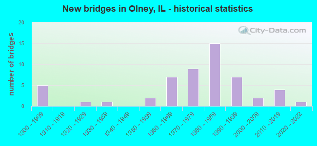
- New bridges - historical statistics
- 51900-1909
- 11920-1929
- 11930-1939
- 21950-1959
- 71960-1969
- 91970-1979
- 151980-1989
- 71990-1999
- 22000-2009
- 42010-2019
- 12020-2022


- Bridge Condition - Deck
- 2.2%Excellent
- 35.6%Very good
- 33.3%Good
- 17.8%Satisfactory
- 8.9%Fair
- 2.2%Poor

- Bridge Condition - Superstructure
- 2.2%Excellent
- 37.0%Very good
- 30.4%Good
- 10.9%Satisfactory
- 19.6%Fair

- Bridge Condition - Substructure
- 2.2%Excellent
- 50.0%Very good
- 19.6%Good
- 13.0%Satisfactory
- 8.7%Fair
- 6.5%Poor

- Bridge Condition - Channel
- 2.1%Excellent
- 25.5%Very good
- 38.3%Good
- 21.3%Satisfactory
- 10.6%Fair
- 2.1%Poor

- Bridge Condition - Culverts
- 33.3%Good
- 50.0%Satisfactory
- 16.7%Fair
Find on map >> Show street view
Structure Number: 800002, Location: 1 MI W JCT ILL-130 (Lat: 38.714111, Lng: -88.113044), Route carried "on" structure: US 50, Year Built: 1961, Status: Open, Structure Length: 8.35m (27.40ft), Average Daily Traffic: 4,200 (year 2021), Truck Traffic: 24%, Average Future Daily Traffic: 5,200 (year 2032), Design Load: HS 20, Features Intersected: FOX RIVER
Minimum Vertical Clearance: 30+ m (98+ ft), Kilometerpoint: 206.538, Lanes on structure: 2, Base Highway Network: Yes, Owner: State Highway Agency, Approaching Roadway Width: 9.1m (29.9ft), Material/Design: Steel continuous, Design/Construction: Stringer/Multi-beam, Number Of Spans In Main Unit: 3, Length of Maximum Span: 32.0m (105.0ft), Curb or Sidewalk Widths: Left: 0.6m (2.0ft), Right: 0.6m (2.0ft), Curb-To-Curb Width: 9.1m (29.9ft), Out-to-Out Width: 10.9m (35.8ft)
Condition: Deck: Satisfactory, Superstructure: Fair, Substructure: Satisfactory, Channel: Good, Operating Rating: 60.3 metric tons, Method Used To Determine Operating Rating: Load Factor (LF) rating reported by rating factor (RF) method using MS18 loading, Inventory Rating: 36.3 metric tons, Method Used To Determine Inventory Rating: Load Factor (LF) rating reported by rating factor (RF) method using MS18 loading, Structural Evaluation: Somewhat better than minimum adequacy, Deck Geometry: Meets minimum limits, Waterway Adequacy: Equal to present desirable criteria, Approach Roadway Alignment: Equal to present desirable criteria, Designated Inspection Frequency: Every 24 months, Inspection Date: September 2021, Deck Structure Type: Concrete Cast-file-Place, Wearing Surface/Protective System: Wearing Surface: Other
Find on map >> Show street view
Structure Number: 800003, Location: .4 MI E JCT ILL-130 (Lat: 38.714450, Lng: -88.088156), Route carried "on" structure: US 50, Year Built: 1963, Status: Open, Structure Length: 4.94m (16.21ft), Average Daily Traffic: 3,350 (year 2021), Truck Traffic: 17%, Average Future Daily Traffic: 3,850 (year 2032), Design Load: HS 20, Features Intersected: RAILROAD
Minimum Vertical Clearance: 30+ m (98+ ft), Kilometerpoint: 208.855, Lanes on structure: 2, Base Highway Network: Yes, Owner: State Highway Agency, Approaching Roadway Width: 9.1m (29.9ft), Material/Design: Steel continuous, Design/Construction: Stringer/Multi-beam, Number Of Spans In Main Unit: 3, Length of Maximum Span: 17.7m (58.1ft), Curb-To-Curb Width: 9.1m (29.9ft), Out-to-Out Width: 11.0m (36.1ft)
Condition: Deck: Satisfactory, Superstructure: Satisfactory, Substructure: Satisfactory, Operating Rating: 63.8 metric tons, Method Used To Determine Operating Rating: Load Factor (LF) rating reported by rating factor (RF) method using MS18 loading, Inventory Rating: 36.6 metric tons, Method Used To Determine Inventory Rating: Load Factor (LF) rating reported by rating factor (RF) method using MS18 loading, Structural Evaluation: Equal to present minimum criteria, Deck Geometry: Meets minimum limits, Underclear: Better than present minimum criteria, Approach Roadway Alignment: Equal to present desirable criteria, Designated Inspection Frequency: Every 24 months, Inspection Date: November 2021, Deck Structure Type: Concrete Cast-file-Place, Wearing Surface/Protective System: Wearing Surface: Other
Find on map >> Show street view
Structure Number: 800004, Location: OLNEY (Lat: 38.714461, Lng: -88.087333), Route carried "on" structure: US 50, Year Built: 1963, Status: Open, Structure Length: 4.42m (14.50ft), Average Daily Traffic: 3,350 (year 2021), Truck Traffic: 17%, Average Future Daily Traffic: 3,850 (year 2032), Design Load: HS 20, Features Intersected: FAU-8492/WHITTLE AVE
Minimum Vertical Clearance: 30+ m (98+ ft), Kilometerpoint: 208.952, Lanes on structure: 2, Lanes under structure: 2, Base Highway Network: Yes, Owner: State Highway Agency, Approaching Roadway Width: 9.1m (29.9ft), Material/Design: Steel continuous, Design/Construction: Stringer/Multi-beam, Number Of Spans In Main Unit: 3, Length of Maximum Span: 16.5m (54.1ft), Curb-To-Curb Width: 9.1m (29.9ft), Out-to-Out Width: 10.9m (35.8ft)
Condition: Deck: Fair, Superstructure: Fair, Substructure: Good, Operating Rating: 58.0 metric tons, Method Used To Determine Operating Rating: Load Factor (LF) rating reported by rating factor (RF) method using MS18 loading, Inventory Rating: 34.7 metric tons, Method Used To Determine Inventory Rating: Load Factor (LF) rating reported by rating factor (RF) method using MS18 loading, Structural Evaluation: Somewhat better than minimum adequacy, Deck Geometry: Meets minimum limits, Underclear: Equal to present minimum criteria, Approach Roadway Alignment: Equal to present desirable criteria, Designated Inspection Frequency: Every 24 months, Inspection Date: November 2021, Deck Structure Type: Concrete Cast-file-Place, Wearing Surface/Protective System: Wearing Surface: Other
Find on map >> Show street view
Structure Number: 800005, Location: 2 MI E JCT ILL-130 (Lat: 38.724072, Lng: -88.062747), Route carried "on" structure: US 50, Year Built: 1963, Status: Open, Structure Length: 6.37m (20.90ft), Average Daily Traffic: 3,550 (year 2021), Truck Traffic: 18%, Average Future Daily Traffic: 3,300 (year 2032), Design Load: HS 20, Features Intersected: CSXT RR.
Minimum Vertical Clearance: 30+ m (98+ ft), Kilometerpoint: 211.253, Lanes on structure: 2, Base Highway Network: Yes, Owner: State Highway Agency, Approaching Roadway Width: 9.1m (29.9ft), Skew: 4 degrees, Material/Design: Steel continuous, Design/Construction: Stringer/Multi-beam, Number Of Spans In Main Unit: 3, Length of Maximum Span: 22.9m (75.1ft), Curb-To-Curb Width: 9.1m (29.9ft), Out-to-Out Width: 10.9m (35.8ft)
Condition: Deck: Satisfactory, Superstructure: Fair, Substructure: Satisfactory, Operating Rating: 66.7 metric tons, Method Used To Determine Operating Rating: Load Factor (LF) rating reported by rating factor (RF) method using MS18 loading, Inventory Rating: 34.3 metric tons, Method Used To Determine Inventory Rating: Load Factor (LF) rating reported by rating factor (RF) method using MS18 loading, Structural Evaluation: Somewhat better than minimum adequacy, Deck Geometry: Meets minimum limits, Underclear: Better than present minimum criteria, Approach Roadway Alignment: Equal to present desirable criteria, Designated Inspection Frequency: Every 24 months, Inspection Date: December 2021, Deck Structure Type: Concrete Cast-file-Place, Wearing Surface/Protective System: Wearing Surface: Other
Find on map >> Show street view
Structure Number: 800009, Location: 6 MI S JASPER CO LN (Lat: 38.762561, Lng: -88.094544), Route carried "on" structure: State highway 130, Year Built: 1927, Year Reconstructed: 1983, Status: Open, Structure Length: 4.02m (13.19ft), Average Daily Traffic: 5,500 (year 2021), Truck Traffic: 19%, Average Future Daily Traffic: 6,500 (year 2032), Design Load: HS 20, Features Intersected: EAST FORK FOX RIVER
Minimum Vertical Clearance: 30+ m (98+ ft), Kilometerpoint: 57.806, Lanes on structure: 2, Base Highway Network: Yes, Owner: State Highway Agency, Approaching Roadway Width: 9.1m (29.9ft), Skew: 4 degrees, Material/Design: Steel continuous, Design/Construction: Stringer/Multi-beam, Number Of Spans In Main Unit: 3, Length of Maximum Span: 12.8m (42.0ft), Curb-To-Curb Width: 10.9m (35.8ft), Out-to-Out Width: 11.9m (39.0ft)
Condition: Deck: Satisfactory, Superstructure: Fair, Substructure: Good, Channel: Good, Operating Rating: 59.3 metric tons, Method Used To Determine Operating Rating: Load Factor (LF) rating reported by rating factor (RF) method using MS18 loading, Inventory Rating: 35.6 metric tons, Method Used To Determine Inventory Rating: Load Factor (LF) rating reported by rating factor (RF) method using MS18 loading, Structural Evaluation: Somewhat better than minimum adequacy, Deck Geometry: Meets minimum limits, Waterway Adequacy: Equal to present desirable criteria, Approach Roadway Alignment: Equal to present desirable criteria, Designated Inspection Frequency: Every 24 months, Inspection Date: Febuary 2022, Deck Structure Type: Concrete Cast-file-Place, Wearing Surface/Protective System: Deck Protection: Epoxy Coated Reinforcing
Find on map >> Show street view
Structure Number: 800021, Location: 3 MI S JASPER CO LN (Lat: 38.803914, Lng: -88.094414), Route carried "on" structure: State highway 130, Year Built: 1983, Status: Open, Structure Length: 4.45m (14.60ft), Average Daily Traffic: 4,600 (year 2021), Truck Traffic: 22%, Average Future Daily Traffic: 5,100 (year 2032), Design Load: HS 20, Features Intersected: LONG BR FOX RIVER
Minimum Vertical Clearance: 30+ m (98+ ft), Kilometerpoint: 62.393, Lanes on structure: 2, Base Highway Network: Yes, Owner: State Highway Agency, Approaching Roadway Width: 9.1m (29.9ft), Skew: 4 degrees, Material/Design: Steel continuous, Design/Construction: Stringer/Multi-beam, Number Of Spans In Main Unit: 3, Length of Maximum Span: 16.2m (53.1ft), Curb-To-Curb Width: 11.0m (36.1ft), Out-to-Out Width: 11.9m (39.0ft)
Condition: Deck: Satisfactory, Superstructure: Good, Substructure: Good, Channel: Good, Operating Rating: 64.5 metric tons, Method Used To Determine Operating Rating: Load Factor (LF) rating reported by rating factor (RF) method using MS18 loading, Inventory Rating: 38.6 metric tons, Method Used To Determine Inventory Rating: Load Factor (LF) rating reported by rating factor (RF) method using MS18 loading, Structural Evaluation: Better than present minimum criteria, Deck Geometry: Somewhat better than minimum adequacy, Waterway Adequacy: Equal to present minimum criteria, Approach Roadway Alignment: Equal to present desirable criteria, Designated Inspection Frequency: Every 48 months, Inspection Date: January 2020, Deck Structure Type: Concrete Cast-file-Place, Wearing Surface/Protective System: Deck Protection: Epoxy Coated Reinforcing
Find on map >> Show street view
Structure Number: 800022, Location: 1.5 MI W OLNEY (Lat: 38.721978, Lng: -88.116042), Route carried "on" structure: State highway 250, Year Built: 1984, Status: Open, Structure Length: 5.27m (17.29ft), Average Daily Traffic: 2,550 (year 2021), Truck Traffic: 6%, Average Future Daily Traffic: 2,400 (year 2032), Design Load: HS 20, Features Intersected: FOX RIVER
Minimum Vertical Clearance: 30+ m (98+ ft), Kilometerpoint: 12.907, Lanes on structure: 2, Owner: State Highway Agency, Approaching Roadway Width: 9.1m (29.9ft), Material/Design: Steel continuous, Design/Construction: Stringer/Multi-beam, Number Of Spans In Main Unit: 3, Length of Maximum Span: 18.9m (62.0ft), Curb-To-Curb Width: 9.8m (32.2ft), Out-to-Out Width: 10.7m (35.1ft)
Condition: Deck: Good, Superstructure: Satisfactory, Substructure: Good, Channel: Good, Operating Rating: 71.9 metric tons, Method Used To Determine Operating Rating: Load Factor (LF) rating reported by rating factor (RF) method using MS18 loading, Inventory Rating: 43.4 metric tons, Method Used To Determine Inventory Rating: Load Factor (LF) rating reported by rating factor (RF) method using MS18 loading, Structural Evaluation: Equal to present minimum criteria, Deck Geometry: Meets minimum limits, Waterway Adequacy: Equal to present desirable criteria, Approach Roadway Alignment: Equal to present desirable criteria, Designated Inspection Frequency: Every 24 months, Inspection Date: September 2021, Deck Structure Type: Concrete Cast-file-Place, Wearing Surface/Protective System: Deck Protection: Epoxy Coated Reinforcing
Find on map >> Show street view
Structure Number: 800023, Location: 4.25 MI W OLNEY (Lat: 38.717697, Lng: -88.163781), Route carried "on" structure: State highway 250, Year Built: 1996, Status: Open, Structure Length: 2.10m (6.89ft), Average Daily Traffic: 2,350 (year 2021), Truck Traffic: 5%, Average Future Daily Traffic: 2,200 (year 2032), Design Load: HS 20, Features Intersected: SUGAR CREEK
Minimum Vertical Clearance: 30+ m (98+ ft), Kilometerpoint: 8.658, Lanes on structure: 2, Owner: State Highway Agency, Approaching Roadway Width: 7.9m (25.9ft), Skew: 1 degrees, Material/Design: Steel, Design/Construction: Stringer/Multi-beam, Number Of Spans In Main Unit: 1, Length of Maximum Span: 20.3m (66.6ft), Curb-To-Curb Width: 9.8m (32.2ft), Out-to-Out Width: 10.7m (35.1ft)
Condition: Deck: Good, Superstructure: Satisfactory, Substructure: Good, Channel: Very good, Operating Rating: 82.3 metric tons, Method Used To Determine Operating Rating: Load Factor (LF) rating reported by rating factor (RF) method using MS18 loading, Inventory Rating: 49.2 metric tons, Method Used To Determine Inventory Rating: Load Factor (LF) rating reported by rating factor (RF) method using MS18 loading, Structural Evaluation: Equal to present minimum criteria, Deck Geometry: Meets minimum limits, Waterway Adequacy: Better than present minimum criteria, Approach Roadway Alignment: Equal to present desirable criteria, Designated Inspection Frequency: Every 24 months, Inspection Date: July 2020, Deck Structure Type: Concrete Cast-file-Place, Wearing Surface/Protective System: Deck Protection: Epoxy Coated Reinforcing
Find on map >> Show street view
Structure Number: 800024, Location: 3.5 MI S JCT US-50 (Lat: 38.669694, Lng: -88.084739), Route carried "on" structure: State highway 130, Year Built: 1999, Status: Open, Structure Length: 2.46m (8.07ft), Average Daily Traffic: 4,400 (year 2021), Truck Traffic: 22%, Average Future Daily Traffic: 4,350 (year 2032), Design Load: HS 20, Features Intersected: LITTLE FOX RIVER
Minimum Vertical Clearance: 30+ m (98+ ft), Kilometerpoint: 47.249, Lanes on structure: 2, Base Highway Network: Yes, Owner: State Highway Agency, Approaching Roadway Width: 11.0m (36.1ft), Material/Design: Prestressed concrete, Design/Construction: Stringer/Multi-beam, Number Of Spans In Main Unit: 1, Length of Maximum Span: 23.1m (75.8ft), Curb-To-Curb Width: 12.0m (39.4ft), Out-to-Out Width: 13.0m (42.7ft)
Condition: Deck: Good, Superstructure: Very good, Substructure: Very good, Channel: Good, Operating Rating: 82.0 metric tons, Method Used To Determine Operating Rating: Load Factor (LF) rating reported by rating factor (RF) method using MS18 loading, Inventory Rating: 47.3 metric tons, Method Used To Determine Inventory Rating: Load Factor (LF) rating reported by rating factor (RF) method using MS18 loading, Structural Evaluation: Equal to present desirable criteria, Deck Geometry: Somewhat better than minimum adequacy, Waterway Adequacy: Equal to present desirable criteria, Approach Roadway Alignment: Equal to present desirable criteria, Designated Inspection Frequency: Every 48 months, Inspection Date: July 2021, Deck Structure Type: Concrete Cast-file-Place, Wearing Surface/Protective System: Deck Protection: Epoxy Coated Reinforcing
Find on map >> Show street view
Structure Number: 802, Location: 3 MI W OLNEY (Lat: 38.707267, Lng: -88.150858), Route carried "on" structure: US 50, Year Built: 1963, Status: Open, Structure Length: 1.29m (4.23ft), Average Daily Traffic: 3,650 (year 2021), Truck Traffic: 19%, Average Future Daily Traffic: 3,900 (year 2032), Design Load: HS 20, Features Intersected: SUGAR CREEK
Minimum Vertical Clearance: 30+ m (98+ ft), Kilometerpoint: 203.142, Lanes on structure: 2, Base Highway Network: Yes, Owner: State Highway Agency, Approaching Roadway Width: 13.4m (44.0ft), Skew: 1 degrees, Material/Design: Concrete, Design/Construction: Culvert, Number Of Spans In Main Unit: 3, Length of Maximum Span: 4.9m (16.1ft)
Condition: Channel: Satisfactory, Culverts: Satisfactory, Operating Rating: 77.4 metric tons, Method Used To Determine Operating Rating: Load Factor (LF) rating reported by rating factor (RF) method using MS18 loading, Inventory Rating: 46.3 metric tons, Method Used To Determine Inventory Rating: Load Factor (LF) rating reported by rating factor (RF) method using MS18 loading, Structural Evaluation: Equal to present minimum criteria, Waterway Adequacy: Equal to present desirable criteria, Approach Roadway Alignment: Equal to present desirable criteria, Designated Inspection Frequency: Every 24 months, Inspection Date: November 2021
Find on map >> Show street view
Structure Number: 802002, Location: 2 MI W ILL-130 (Lat: 38.710197, Lng: -88.138875), Route carried "on" structure: US 50, Year Built: 1963, Status: Open, Structure Length: 0.70m (2.30ft), Average Daily Traffic: 3,650 (year 2021), Truck Traffic: 19%, Average Future Daily Traffic: 3,900 (year 2032), Design Load: HS 20, Features Intersected: E BR SUGAR CREEK
Minimum Vertical Clearance: 30+ m (98+ ft), Kilometerpoint: 204.236, Lanes on structure: 2, Base Highway Network: Yes, Owner: State Highway Agency, Approaching Roadway Width: 9.1m (29.9ft), Skew: 1 degrees, Material/Design: Concrete, Design/Construction: Culvert, Number Of Spans In Main Unit: 2, Length of Maximum Span: 3.4m (11.2ft)
Condition: Channel: Satisfactory, Culverts: Satisfactory, Operating Rating: 93.0 metric tons, Method Used To Determine Operating Rating: Load Factor (LF) rating reported by rating factor (RF) method using MS18 loading, Inventory Rating: 55.7 metric tons, Method Used To Determine Inventory Rating: Load Factor (LF) rating reported by rating factor (RF) method using MS18 loading, Structural Evaluation: Equal to present minimum criteria, Waterway Adequacy: Equal to present desirable criteria, Approach Roadway Alignment: Equal to present desirable criteria, Designated Inspection Frequency: Every 24 months, Inspection Date: November 2021
Find on map >> Show street view
Structure Number: 802003, Location: .5 MI N JCT ILL-250 (Lat: 38.737372, Lng: -88.094500), Route carried "on" structure: State highway 130, Year Built: 1977, Status: Open, Structure Length: 0.99m (3.25ft), Average Daily Traffic: 9,800 (year 2021), Truck Traffic: 12%, Average Future Daily Traffic: 12,200 (year 2032), Design Load: HS 20, Features Intersected: STREAM
Minimum Vertical Clearance: 30+ m (98+ ft), Kilometerpoint: 55.006, Lanes on structure: 4, Base Highway Network: Yes, Owner: State Highway Agency, Approaching Roadway Width: 20.1m (65.9ft), Skew: 23 degrees, Material/Design: Concrete, Design/Construction: Culvert, Number Of Spans In Main Unit: 2, Length of Maximum Span: 4.8m (15.7ft)
Condition: Channel: Good, Culverts: Satisfactory, Operating Rating: 95.9 metric tons, Method Used To Determine Operating Rating: Load Factor (LF) rating reported by rating factor (RF) method using MS18 loading, Inventory Rating: 57.3 metric tons, Method Used To Determine Inventory Rating: Load Factor (LF) rating reported by rating factor (RF) method using MS18 loading, Structural Evaluation: Equal to present minimum criteria, Waterway Adequacy: Equal to present desirable criteria, Approach Roadway Alignment: Equal to present desirable criteria, Designated Inspection Frequency: Every 24 months, Inspection Date: September 2021
Find on map >> Show street view
Structure Number: 802004, Location: 2.25 MI S. JCT US-50 (Lat: 38.687094, Lng: -88.084794), Route carried "on" structure: State highway 130, Year Built: 1999, Status: Open, Structure Length: 1.93m (6.33ft), Average Daily Traffic: 4,400 (year 2021), Truck Traffic: 22%, Average Future Daily Traffic: 4,700 (year 2032), Design Load: HS 20, Features Intersected: BIG CREEK
Minimum Vertical Clearance: 30+ m (98+ ft), Kilometerpoint: 49.180, Lanes on structure: 2, Base Highway Network: Yes, Owner: State Highway Agency, Approaching Roadway Width: 12.2m (40.0ft), Skew: 2 degrees, Material/Design: Concrete, Design/Construction: Frame, Number Of Spans In Main Unit: 2, Length of Maximum Span: 9.3m (30.5ft)
Condition: Superstructure: Good, Substructure: Good, Channel: Good, Operating Rating: 71.0 metric tons, Method Used To Determine Operating Rating: Load Factor (LF) rating reported by rating factor (RF) method using MS18 loading, Inventory Rating: 42.4 metric tons, Method Used To Determine Inventory Rating: Load Factor (LF) rating reported by rating factor (RF) method using MS18 loading, Structural Evaluation: Better than present minimum criteria, Waterway Adequacy: Equal to present desirable criteria, Approach Roadway Alignment: Equal to present desirable criteria, Length Of Structure Improvement: 1.92m (6.30ft), Designated Inspection Frequency: Every 48 months, Inspection Date: Febuary 2022, Bridge Improvement Cost: $533,000, Roadway Improvement Cost: $61,000, Total Project Cost: $594,000
Find on map >> Show street view
Structure Number: 802005, Location: 3 MI W OLNEY (Lat: 38.722031, Lng: -88.144289), Route carried "on" structure: State highway 250, Year Built: 2011, Status: Open, Structure Length: 0.86m (2.82ft), Average Daily Traffic: 2,350 (year 2021), Truck Traffic: 5%, Average Future Daily Traffic: 2,200 (year 2032), Design Load: HS 20, Features Intersected: STREAM
Minimum Vertical Clearance: 30+ m (98+ ft), Kilometerpoint: 10.428, Lanes on structure: 2, Owner: State Highway Agency, Approaching Roadway Width: 7.3m (24.0ft), Material/Design: Concrete, Design/Construction: Culvert, Number Of Spans In Main Unit: 2, Length of Maximum Span: 4.0m (13.1ft)
Condition: Channel: Satisfactory, Culverts: Good, Operating Rating: 54.1 metric tons, Method Used To Determine Operating Rating: Load Factor (LF) rating reported by rating factor (RF) method using MS18 loading, Inventory Rating: 32.4 metric tons, Method Used To Determine Inventory Rating: Load Factor (LF) rating reported by rating factor (RF) method using MS18 loading, Structural Evaluation: Better than present minimum criteria, Waterway Adequacy: Better than present minimum criteria, Approach Roadway Alignment: Equal to present desirable criteria, Designated Inspection Frequency: Every 48 months, Inspection Date: January 2021
Find on map >> Show street view
Structure Number: 803017, Location: 2.5 MI E NOBLE (Lat: 38.686906, Lng: -88.167508), Route carried "on" structure: County highway , Year Built: 1950, Status: Open, Structure Length: 1.01m (3.31ft), Average Daily Traffic: 225 (year 2018), Truck Traffic: 3%, Average Future Daily Traffic: 175 (year 2032), Features Intersected: CREEK, Facility Carried by Structure: FAS-1722
Minimum Vertical Clearance: 30+ m (98+ ft), Kilometerpoint: 3.267, Lanes on structure: 2, Owner: County Highway Agency, Approaching Roadway Width: 9.1m (29.9ft), Material/Design: Steel, Design/Construction: Stringer/Multi-beam, Number Of Spans In Main Unit: 1, Length of Maximum Span: 9.1m (29.9ft), Curb-To-Curb Width: 6.7m (22.0ft), Out-to-Out Width: 7.6m (24.9ft)
Condition: Deck: Satisfactory, Superstructure: Fair, Substructure: Fair, Channel: Fair, Operating Rating: 44.4 metric tons, Method Used To Determine Operating Rating: Load Factor (LF) rating reported by rating factor (RF) method using MS18 loading, Inventory Rating: 32.4 metric tons, Method Used To Determine Inventory Rating: Load Factor (LF) rating reported by rating factor (RF) method using MS18 loading, Structural Evaluation: Somewhat better than minimum adequacy, Deck Geometry: Meets minimum limits, Waterway Adequacy: Meets minimum limits, Approach Roadway Alignment: Somewhat better than minimum adequacy, Designated Inspection Frequency: Every 24 months, Inspection Date: Febuary 2021, Deck Structure Type: Concrete Cast-file-Place, Wearing Surface/Protective System: Wearing Surface: Gravel
Find on map >> Show street view
Structure Number: 803042, Location: 1.5 MI SE DUNDAS (Lat: 38.814133, Lng: -88.068692), Route carried "on" structure: County highway , Year Built: 1909, Status: Posted for load, Structure Length: 0.73m (2.40ft), Average Daily Traffic: 50 (year 2018), Truck Traffic: 6%, Average Future Daily Traffic: 25 (year 2032), Features Intersected: JACK OAK CREEK, Facility Carried by Structure: TR-41
Minimum Vertical Clearance: 30+ m (98+ ft), Kilometerpoint: 1.046, Lanes on structure: 2, Owner: Town or Township Highway Agency, Approaching Roadway Width: 6.7m (22.0ft), Material/Design: Steel, Design/Construction: Stringer/Multi-beam, Number Of Spans In Main Unit: 2, Length of Maximum Span: 3.4m (11.2ft), Curb-To-Curb Width: 6.4m (21.0ft), Out-to-Out Width: 6.4m (21.0ft)
Condition: Deck: Fair, Superstructure: Fair, Substructure: Fair, Channel: Fair, Operating Rating: 14.9 metric tons, Method Used To Determine Operating Rating: Load Factor (LF) rating reported by rating factor (RF) method using MS18 loading, Inventory Rating: 7.8 metric tons, Method Used To Determine Inventory Rating: Load Factor (LF) rating reported by rating factor (RF) method using MS18 loading, Structural Evaluation: High priority of replacement, Deck Geometry: Somewhat better than minimum adequacy, Waterway Adequacy: High priority of corrective action, Approach Roadway Alignment: Equal to present minimum criteria, Bridge Posting: Required (Relationship of Operating Rating to Maximum Legal Load: > 39.9% below), Length Of Structure Improvement: 1.31m (4.30ft), Designated Inspection Frequency: Every 24 months, Inspection Date: January 2022, Bridge Improvement Cost: $54,000, Roadway Improvement Cost: $6,000, Total Project Cost: $82,000, Deck Structure Type: Concrete Cast-file-Place
Find on map >> Show street view
Structure Number: 803047, Location: 3.25 MI SE DUNDAS (Lat: 38.790350, Lng: -88.055533), Route carried "on" structure: County highway , Year Built: 1909, Status: Posted for load, Structure Length: 0.79m (2.59ft), Average Daily Traffic: 100 (year 2018), Truck Traffic: 8%, Average Future Daily Traffic: 125 (year 2032), Features Intersected: GOOSE CREEK, Facility Carried by Structure: TR-61
Minimum Vertical Clearance: 30+ m (98+ ft), Kilometerpoint: 8.175, Lanes on structure: 2, Owner: Town or Township Highway Agency, Approaching Roadway Width: 7.3m (24.0ft), Material/Design: Concrete, Design/Construction: Channel Beam, Number Of Spans In Main Unit: 1, Length of Maximum Span: 7.6m (24.9ft), Curb-To-Curb Width: 6.7m (22.0ft), Out-to-Out Width: 6.9m (22.6ft)
Condition: Deck: Good, Superstructure: Good, Substructure: Fair, Channel: Good, Operating Rating: 29.2 metric tons, Method Used To Determine Operating Rating: Field evaluation and documented engineering judgment, Inventory Rating: 17.5 metric tons, Method Used To Determine Inventory Rating: Field evaluation and documented engineering judgment, Structural Evaluation: Somewhat better than minimum adequacy, Deck Geometry: Somewhat better than minimum adequacy, Waterway Adequacy: Equal to present minimum criteria, Approach Roadway Alignment: Equal to present minimum criteria, Bridge Posting: Required (Relationship of Operating Rating to Maximum Legal Load: 0.1 - 9.9% below), Length Of Structure Improvement: 0.79m (2.59ft), Designated Inspection Frequency: Every 24 months, Other Special Inspection Frequency: Every 12 months, Inspection Date: Febuary 2021, Other Special Inspection Date: Febuary 2021, Bridge Improvement Cost: $34,000, Roadway Improvement Cost: $4,000, Total Project Cost: $50,000, Deck Structure Type: Concrete Precast Panels
Find on map >> Show street view
Structure Number: 803065, Location: 0.5 MI W OLNEY (Lat: 38.734303, Lng: -88.111156), Route carried "on" structure: County highway , Year Built: 1909, Status: Open, Structure Length: 1.07m (3.51ft), Average Daily Traffic: 50 (year 2018), Truck Traffic: 4%, Average Future Daily Traffic: 50 (year 2032), Features Intersected: CREEK, Facility Carried by Structure: TR-119
Minimum Vertical Clearance: 30+ m (98+ ft), Kilometerpoint: 8.401, Lanes on structure: 1, Owner: Town or Township Highway Agency, Approaching Roadway Width: 6.1m (20.0ft), Material/Design: Steel, Design/Construction: Stringer/Multi-beam, Number Of Spans In Main Unit: 1, Length of Maximum Span: 10.7m (35.1ft), Curb-To-Curb Width: 4.8m (15.7ft), Out-to-Out Width: 5.1m (16.7ft)
Condition: Deck: Satisfactory, Superstructure: Satisfactory, Substructure: Satisfactory, Channel: Poor, Operating Rating: 50.5 metric tons, Method Used To Determine Operating Rating: Allowable Stress (AS) rating reported by rating factor (RF) method using MS18 loading, Inventory Rating: 36.3 metric tons, Method Used To Determine Inventory Rating: Allowable Stress (AS) rating reported by rating factor (RF) method using MS18 loading, Structural Evaluation: Equal to present minimum criteria, Deck Geometry: Equal to present desirable criteria, Waterway Adequacy: High priority of corrective action, Approach Roadway Alignment: Meets minimum limits, Length Of Structure Improvement: 1.07m (3.51ft), Designated Inspection Frequency: Every 24 months, Inspection Date: March 2020, Bridge Improvement Cost: $70,000, Roadway Improvement Cost: $12,000, Total Project Cost: $82,000, Deck Structure Type: Wood or Timber, Wearing Surface/Protective System: Wearing Surface: Wood or Timber
Find on map >> Show street view
Structure Number: 803067, Location: 2 MI NW VERNOR LAKE (Lat: 38.789600, Lng: -88.112872), Route carried "on" structure: County highway , Year Built: 1909, Status: Posted for load, Structure Length: 0.73m (2.40ft), Average Daily Traffic: 50 (year 2018), Truck Traffic: 2%, Average Future Daily Traffic: 25 (year 2032), Features Intersected: CREEK, Facility Carried by Structure: TR-120
Minimum Vertical Clearance: 30+ m (98+ ft), Kilometerpoint: 3.219, Lanes on structure: 1, Owner: Town or Township Highway Agency, Approaching Roadway Width: 6.7m (22.0ft), Material/Design: Steel, Design/Construction: Stringer/Multi-beam, Number Of Spans In Main Unit: 1, Length of Maximum Span: 6.9m (22.6ft), Curb-To-Curb Width: 4.3m (14.1ft), Out-to-Out Width: 4.3m (14.1ft)
Condition: Deck: Poor, Superstructure: Fair, Substructure: Poor, Channel: Fair, Operating Rating: 21.7 metric tons, Method Used To Determine Operating Rating: Load Factor (LF) rating reported by rating factor (RF) method using MS18 loading, Inventory Rating: 13.0 metric tons, Method Used To Determine Inventory Rating: Load Factor (LF) rating reported by rating factor (RF) method using MS18 loading, Structural Evaluation: Meets minimum limits, Deck Geometry: Equal to present minimum criteria, Waterway Adequacy: Meets minimum limits, Approach Roadway Alignment: Meets minimum limits, Bridge Posting: Required (Relationship of Operating Rating to Maximum Legal Load: > 39.9% below), Length Of Structure Improvement: 1.31m (4.30ft), Designated Inspection Frequency: Every 24 months, Inspection Date: January 2020, Bridge Improvement Cost: $36,000, Roadway Improvement Cost: $4,000, Total Project Cost: $54,000, Deck Structure Type: Concrete Cast-file-Place, Wearing Surface/Protective System: Wearing Surface: Gravel
Find on map >> Show street view
Structure Number: 803083, Location: 2 MI S OLNEY (Lat: 38.692689, Lng: -88.066356), Route carried "on" structure: County highway , Year Built: 1909, Year Reconstructed: 1970, Status: Open, Structure Length: 1.89m (6.20ft), Average Daily Traffic: 325 (year 2018), Truck Traffic: 1%, Average Future Daily Traffic: 325 (year 2032), Features Intersected: BIG CREEK, Facility Carried by Structure: TR-158
Minimum Vertical Clearance: 30+ m (98+ ft), Kilometerpoint: 0.982, Lanes on structure: 2, Owner: Town or Township Highway Agency, Approaching Roadway Width: 7.3m (24.0ft), Material/Design: Steel, Design/Construction: Stringer/Multi-beam, Number Of Spans In Main Unit: 1, Length of Maximum Span: 18.3m (60.0ft), Curb-To-Curb Width: 6.6m (21.7ft), Out-to-Out Width: 6.9m (22.6ft)
Condition: Deck: Good, Superstructure: Good, Substructure: Satisfactory, Channel: Fair, Operating Rating: 43.4 metric tons, Method Used To Determine Operating Rating: Load Factor (LF) rating reported by rating factor (RF) method using MS18 loading, Inventory Rating: 25.9 metric tons, Method Used To Determine Inventory Rating: Load Factor (LF) rating reported by rating factor (RF) method using MS18 loading, Structural Evaluation: Equal to present minimum criteria, Deck Geometry: Meets minimum limits, Waterway Adequacy: Somewhat better than minimum adequacy, Approach Roadway Alignment: Somewhat better than minimum adequacy, Designated Inspection Frequency: Every 24 months, Inspection Date: Febuary 2021, Deck Structure Type: Concrete Cast-file-Place, Wearing Surface/Protective System: Wearing Surface: Gravel
Find on map >> Show street view
Structure Number: 803088, Location: 2 MI SE OLNEY (Lat: 38.698903, Lng: -88.038772), Route carried "on" structure: County highway , Year Built: 1954, Year Reconstructed: 1970, Status: Open, Structure Length: 1.86m (6.10ft), Average Daily Traffic: 200 (year 2018), Truck Traffic: 5%, Average Future Daily Traffic: 200 (year 2032), Features Intersected: BIG CREEK, Facility Carried by Structure: TR-176
Minimum Vertical Clearance: 30+ m (98+ ft), Kilometerpoint: 3.717, Lanes on structure: 2, Owner: Town or Township Highway Agency, Approaching Roadway Width: 7.3m (24.0ft), Material/Design: Steel, Design/Construction: Stringer/Multi-beam, Number Of Spans In Main Unit: 1, Length of Maximum Span: 18.0m (59.1ft), Curb-To-Curb Width: 6.4m (21.0ft), Out-to-Out Width: 6.7m (22.0ft)
Condition: Deck: Good, Superstructure: Good, Substructure: Satisfactory, Channel: Satisfactory, Operating Rating: 58.0 metric tons, Method Used To Determine Operating Rating: Load Factor (LF) rating reported by rating factor (RF) method using MS18 loading, Inventory Rating: 34.7 metric tons, Method Used To Determine Inventory Rating: Load Factor (LF) rating reported by rating factor (RF) method using MS18 loading, Structural Evaluation: Equal to present minimum criteria, Deck Geometry: Meets minimum limits, Waterway Adequacy: Equal to present minimum criteria, Approach Roadway Alignment: Somewhat better than minimum adequacy, Designated Inspection Frequency: Every 24 months, Inspection Date: Febuary 2021, Deck Structure Type: Concrete Cast-file-Place, Wearing Surface/Protective System: Wearing Surface: Gravel
Find on map >> Show street view
Structure Number: 803119, Location: 0.5 MI NE OLNEY (Lat: 38.745078, Lng: -88.111347), Route carried "on" structure: County highway , Year Built: 1972, Status: Open, Structure Length: 5.82m (19.09ft), Average Daily Traffic: 1,200 (year 2018), Truck Traffic: 8%, Average Future Daily Traffic: 900 (year 2032), Design Load: HS 20, Features Intersected: FOX RIVER, Facility Carried by Structure: CH-10
Minimum Vertical Clearance: 30+ m (98+ ft), Kilometerpoint: 10.605, Lanes on structure: 2, Owner: County Highway Agency, Approaching Roadway Width: 9.1m (29.9ft), Skew: 3 degrees, Material/Design: Steel continuous, Design/Construction: Stringer/Multi-beam, Number Of Spans In Main Unit: 4, Length of Maximum Span: 15.5m (50.9ft), Curb-To-Curb Width: 8.1m (26.6ft), Out-to-Out Width: 9.1m (29.9ft)
Condition: Deck: Very good, Superstructure: Very good, Substructure: Very good, Channel: Very good, Operating Rating: 69.3 metric tons, Method Used To Determine Operating Rating: Load Factor (LF) rating reported by rating factor (RF) method using MS18 loading, Inventory Rating: 41.5 metric tons, Method Used To Determine Inventory Rating: Load Factor (LF) rating reported by rating factor (RF) method using MS18 loading, Structural Evaluation: Equal to present desirable criteria, Deck Geometry: Meets minimum limits, Waterway Adequacy: Equal to present desirable criteria, Approach Roadway Alignment: Better than present minimum criteria, Designated Inspection Frequency: Every 24 months, Inspection Date: Febuary 2022, Deck Structure Type: Concrete Cast-file-Place, Wearing Surface/Protective System: Wearing Surface: Gravel
Find on map >> Show street view
Structure Number: 80312, Location: 1 MI N OLNEY (Lat: 38.763408, Lng: -88.081372), Route carried "on" structure: County highway , Year Built: 1971, Status: Open, Structure Length: 1.03m (3.38ft), Average Daily Traffic: 1,000 (year 2018), Truck Traffic: 4%, Average Future Daily Traffic: 1,000 (year 2032), Features Intersected: EAST FORK LAKE, Facility Carried by Structure: FAS-1717
Minimum Vertical Clearance: 30+ m (98+ ft), Kilometerpoint: 1.287, Lanes on structure: 2, Owner: Town or Township Highway Agency, Approaching Roadway Width: 7.9m (25.9ft), Skew: 1 degrees, Material/Design: Concrete continuous, Design/Construction: Culvert, Number Of Spans In Main Unit: 2, Length of Maximum Span: 5.0m (16.4ft), Curb-To-Curb Width: 8.5m (27.9ft), Out-to-Out Width: 11.6m (38.1ft)
Condition: Channel: Very good, Culverts: Good, Operating Rating: 40.5 metric tons, Method Used To Determine Operating Rating: Field evaluation and documented engineering judgment, Inventory Rating: 24.3 metric tons, Method Used To Determine Inventory Rating: Field evaluation and documented engineering judgment, Structural Evaluation: Equal to present minimum criteria, Deck Geometry: Somewhat better than minimum adequacy, Waterway Adequacy: Equal to present desirable criteria, Approach Roadway Alignment: Equal to present desirable criteria, Designated Inspection Frequency: Every 24 months, Inspection Date: June 2019, Wearing Surface/Protective System: Wearing Surface: Bituminous
Find on map >> Show street view
Structure Number: 803122, Location: 1.5 MI NW OLNEY (Lat: 38.757103, Lng: -88.131444), Route carried "on" structure: County highway , Year Built: 1977, Status: Open, Structure Length: 1.80m (5.91ft), Average Daily Traffic: 200 (year 2018), Truck Traffic: 2%, Average Future Daily Traffic: 250 (year 2032), Design Load: HS 20, Features Intersected: MASH CREEK, Facility Carried by Structure: TR-102A
Minimum Vertical Clearance: 30+ m (98+ ft), Kilometerpoint: 6.775, Lanes on structure: 2, Owner: Town or Township Highway Agency, Approaching Roadway Width: 7.3m (24.0ft), Material/Design: Prestressed concrete, Design/Construction: Box Beam or Girders - Multiple, Number Of Spans In Main Unit: 1, Length of Maximum Span: 17.4m (57.1ft), Curb-To-Curb Width: 6.3m (20.7ft), Out-to-Out Width: 6.5m (21.3ft)
Condition: Deck: Good, Superstructure: Good, Substructure: Very good, Channel: Satisfactory, Operating Rating: 44.4 metric tons, Method Used To Determine Operating Rating: Assigned rating based on Load Factor Design (LFD) reported by rating factor (RF) using MS18 loading, Inventory Rating: 32.4 metric tons, Method Used To Determine Inventory Rating: Assigned rating based on Load Factor Design (LFD) reported by rating factor (RF) using MS18 loading, Structural Evaluation: Better than present minimum criteria, Deck Geometry: Meets minimum limits, Waterway Adequacy: Better than present minimum criteria, Approach Roadway Alignment: Meets minimum limits, Designated Inspection Frequency: Every 48 months, Inspection Date: Febuary 2018, Deck Structure Type: Concrete Precast Panels
Find on map >> Show street view
Structure Number: 803125, Location: 3.5 MI S OLNEY (Lat: 38.665764, Lng: -88.098567), Route carried "on" structure: County highway , Year Built: 1978, Status: Open, Structure Length: 1.83m (6.00ft), Average Daily Traffic: 50 (year 2018), Truck Traffic: 6%, Average Future Daily Traffic: 10 (year 2032), Design Load: HS 20, Features Intersected: LITTLE FOX CREEK, Facility Carried by Structure: TR-130
Minimum Vertical Clearance: 30+ m (98+ ft), Kilometerpoint: 3.895, Lanes on structure: 2, Owner: Town or Township Highway Agency, Approaching Roadway Width: 6.7m (22.0ft), Skew: 1 degrees, Material/Design: Prestressed concrete, Design/Construction: Box Beam or Girders - Multiple, Number Of Spans In Main Unit: 1, Length of Maximum Span: 17.7m (58.1ft), Curb-To-Curb Width: 6.5m (21.3ft), Out-to-Out Width: 6.5m (21.3ft)
Condition: Deck: Good, Superstructure: Good, Substructure: Very good, Channel: Very good, Operating Rating: 44.4 metric tons, Method Used To Determine Operating Rating: Assigned rating based on Load Factor Design (LFD) reported by rating factor (RF) using MS18 loading, Inventory Rating: 32.4 metric tons, Method Used To Determine Inventory Rating: Assigned rating based on Load Factor Design (LFD) reported by rating factor (RF) using MS18 loading, Structural Evaluation: Better than present minimum criteria, Deck Geometry: Somewhat better than minimum adequacy, Waterway Adequacy: Equal to present desirable criteria, Approach Roadway Alignment: Better than present minimum criteria, Designated Inspection Frequency: Every 48 months, Inspection Date: January 2022, Deck Structure Type: Concrete Precast Panels
Find on map >> Show street view
Structure Number: 803127, Location: 2.5 MI SW DUNDAS (Lat: 38.803311, Lng: -88.102131), Route carried "on" structure: County highway , Year Built: 1973, Status: Open, Structure Length: 1.92m (6.30ft), Average Daily Traffic: 300 (year 2018), Truck Traffic: 4%, Average Future Daily Traffic: 225 (year 2032), Features Intersected: FOX RIVER, Facility Carried by Structure: CH-14
Minimum Vertical Clearance: 30+ m (98+ ft), Kilometerpoint: 12.295, Lanes on structure: 2, Owner: County Highway Agency, Approaching Roadway Width: 9.1m (29.9ft), Material/Design: Prestressed concrete, Design/Construction: Box Beam or Girders - Multiple, Number Of Spans In Main Unit: 1, Length of Maximum Span: 18.6m (61.0ft), Curb-To-Curb Width: 6.2m (20.3ft), Out-to-Out Width: 6.3m (20.7ft)
Condition: Deck: Satisfactory, Superstructure: Satisfactory, Substructure: Fair, Channel: Satisfactory, Operating Rating: 44.4 metric tons, Method Used To Determine Operating Rating: Load Factor (LF) rating reported by rating factor (RF) method using MS18 loading, Inventory Rating: 26.6 metric tons, Method Used To Determine Inventory Rating: Load Factor (LF) rating reported by rating factor (RF) method using MS18 loading, Structural Evaluation: Somewhat better than minimum adequacy, Deck Geometry: Meets minimum limits, Waterway Adequacy: Equal to present minimum criteria, Approach Roadway Alignment: High priority of corrective action, Length Of Structure Improvement: 2.68m (8.79ft), Designated Inspection Frequency: Every 24 months, Inspection Date: January 2020, Bridge Improvement Cost: $138,000, Roadway Improvement Cost: $14,000, Total Project Cost: $208,000, Deck Structure Type: Concrete Precast Panels, Wearing Surface/Protective System: Wearing Surface: Bituminous
Find on map >> Show street view
Structure Number: 803129, Location: 2.5 MI SW OLNEY (Lat: 38.681308, Lng: -88.131275), Route carried "on" structure: County highway , Year Built: 1979, Status: Open, Structure Length: 2.87m (9.42ft), Average Daily Traffic: 75 (year 2018), Truck Traffic: 1%, Average Future Daily Traffic: 50 (year 2032), Design Load: HS 20, Features Intersected: FOX RIVER, Facility Carried by Structure: TR-102
Minimum Vertical Clearance: 30+ m (98+ ft), Kilometerpoint: 2.511, Lanes on structure: 2, Owner: Town or Township Highway Agency, Approaching Roadway Width: 6.1m (20.0ft), Material/Design: Prestressed concrete, Design/Construction: Box Beam or Girders - Multiple, Number Of Spans In Main Unit: 3, Length of Maximum Span: 13.1m (43.0ft), Curb-To-Curb Width: 6.1m (20.0ft), Out-to-Out Width: 6.2m (20.3ft)
Condition: Deck: Good, Superstructure: Good, Substructure: Good, Channel: Good, Operating Rating: 44.4 metric tons, Method Used To Determine Operating Rating: Assigned rating based on Load Factor Design (LFD) reported by rating factor (RF) using MS18 loading, Inventory Rating: 32.4 metric tons, Method Used To Determine Inventory Rating: Assigned rating based on Load Factor Design (LFD) reported by rating factor (RF) using MS18 loading, Structural Evaluation: Better than present minimum criteria, Deck Geometry: Somewhat better than minimum adequacy, Waterway Adequacy: Equal to present minimum criteria, Approach Roadway Alignment: Equal to present minimum criteria, Designated Inspection Frequency: Every 48 months, Inspection Date: January 2019, Deck Structure Type: Concrete Precast Panels
Find on map >> Show street view
Structure Number: 80313, Location: 3 MI S DUNDAS (Lat: 38.788778, Lng: -88.103561), Route carried "on" structure: County highway , Year Built: 1983, Status: Open, Structure Length: 3.72m (12.20ft), Average Daily Traffic: 125 (year 2018), Truck Traffic: 2%, Average Future Daily Traffic: 75 (year 2032), Design Load: HS 20, Features Intersected: FOX RIVER, Facility Carried by Structure: TR-61
Minimum Vertical Clearance: 30+ m (98+ ft), Kilometerpoint: 4.007, Lanes on structure: 2, Owner: Town or Township Highway Agency, Approaching Roadway Width: 7.3m (24.0ft), Skew: 2 degrees, Material/Design: Prestressed concrete, Design/Construction: Box Beam or Girders - Multiple, Number Of Spans In Main Unit: 3, Length of Maximum Span: 11.9m (39.0ft), Curb-To-Curb Width: 7.3m (24.0ft), Out-to-Out Width: 7.3m (24.0ft)
Condition: Deck: Very good, Superstructure: Very good, Substructure: Very good, Channel: Good, Operating Rating: 44.4 metric tons, Method Used To Determine Operating Rating: Assigned rating based on Load Factor Design (LFD) reported by rating factor (RF) using MS18 loading, Inventory Rating: 32.4 metric tons, Method Used To Determine Inventory Rating: Assigned rating based on Load Factor Design (LFD) reported by rating factor (RF) using MS18 loading, Structural Evaluation: Equal to present desirable criteria, Deck Geometry: Somewhat better than minimum adequacy, Waterway Adequacy: Equal to present desirable criteria, Approach Roadway Alignment: Equal to present desirable criteria, Designated Inspection Frequency: Every 48 months, Inspection Date: January 2018, Deck Structure Type: Concrete Precast Panels
Find on map >> Show street view
Structure Number: 803136, Location: 4 MI W CALHOON (Lat: 38.655233, Lng: -88.121919), Route carried "on" structure: County highway , Year Built: 1981, Status: Open, Structure Length: 1.68m (5.51ft), Average Daily Traffic: 50 (year 2018), Truck Traffic: 8%, Average Future Daily Traffic: 25 (year 2032), Design Load: HS 20, Features Intersected: TURKEY CREEK, Facility Carried by Structure: TR-110
Minimum Vertical Clearance: 30+ m (98+ ft), Kilometerpoint: 0.161, Lanes on structure: 2, Owner: Town or Township Highway Agency, Approaching Roadway Width: 6.1m (20.0ft), Skew: 3 degrees, Material/Design: Prestressed concrete, Design/Construction: Box Beam or Girders - Multiple, Number Of Spans In Main Unit: 1, Length of Maximum Span: 15.8m (51.8ft), Curb-To-Curb Width: 7.4m (24.3ft), Out-to-Out Width: 7.4m (24.3ft)
Condition: Deck: Good, Superstructure: Good, Substructure: Good, Channel: Good, Operating Rating: 44.4 metric tons, Method Used To Determine Operating Rating: Assigned rating based on Load Factor Design (LFD) reported by rating factor (RF) using MS18 loading, Inventory Rating: 32.4 metric tons, Method Used To Determine Inventory Rating: Assigned rating based on Load Factor Design (LFD) reported by rating factor (RF) using MS18 loading, Structural Evaluation: Better than present minimum criteria, Deck Geometry: Equal to present minimum criteria, Waterway Adequacy: Equal to present minimum criteria, Approach Roadway Alignment: Equal to present minimum criteria, Designated Inspection Frequency: Every 48 months, Inspection Date: January 2019, Deck Structure Type: Concrete Precast Panels
Find on map >> Show street view
Structure Number: 803138, Location: 3 MI SW OLNEY (Lat: 38.678778, Lng: -88.114528), Route carried "on" structure: County highway , Year Built: 1981, Status: Open, Structure Length: 1.74m (5.71ft), Average Daily Traffic: 50 (year 2018), Truck Traffic: 4%, Average Future Daily Traffic: 25 (year 2032), Design Load: HS 20, Features Intersected: LITTLE FOX CREEK, Facility Carried by Structure: TR-185
Minimum Vertical Clearance: 30+ m (98+ ft), Kilometerpoint: 1.448, Lanes on structure: 2, Owner: Town or Township Highway Agency, Approaching Roadway Width: 7.3m (24.0ft), Material/Design: Prestressed concrete, Design/Construction: Box Beam or Girders - Multiple, Number Of Spans In Main Unit: 1, Length of Maximum Span: 16.8m (55.1ft), Curb-To-Curb Width: 7.4m (24.3ft), Out-to-Out Width: 7.4m (24.3ft)
Condition: Deck: Very good, Superstructure: Very good, Substructure: Very good, Channel: Satisfactory, Operating Rating: 44.4 metric tons, Method Used To Determine Operating Rating: Assigned rating based on Load Factor Design (LFD) reported by rating factor (RF) using MS18 loading, Inventory Rating: 32.4 metric tons, Method Used To Determine Inventory Rating: Assigned rating based on Load Factor Design (LFD) reported by rating factor (RF) using MS18 loading, Structural Evaluation: Equal to present desirable criteria, Deck Geometry: Equal to present minimum criteria, Waterway Adequacy: Equal to present minimum criteria, Approach Roadway Alignment: Equal to present minimum criteria, Designated Inspection Frequency: Every 48 months, Inspection Date: January 2019, Deck Structure Type: Concrete Precast Panels
Find on map >> Show street view
Structure Number: 803142, Location: 1 MI SW OLNEY (Lat: 38.704289, Lng: -88.111056), Route carried "on" structure: County highway , Year Built: 1982, Status: Open, Structure Length: 2.32m (7.61ft), Average Daily Traffic: 75 (year 2018), Truck Traffic: 7%, Average Future Daily Traffic: 50 (year 2032), Design Load: HS 20, Features Intersected: FOX RIVER, Facility Carried by Structure: TR-151
Minimum Vertical Clearance: 30+ m (98+ ft), Kilometerpoint: 1.529, Lanes on structure: 2, Owner: Town or Township Highway Agency, Approaching Roadway Width: 5.5m (18.0ft), Material/Design: Prestressed concrete, Design/Construction: Box Beam or Girders - Multiple, Number Of Spans In Main Unit: 3, Length of Maximum Span: 7.3m (24.0ft), Curb-To-Curb Width: 7.3m (24.0ft), Out-to-Out Width: 7.4m (24.3ft)
Condition: Deck: Very good, Superstructure: Very good, Substructure: Very good, Channel: Satisfactory, Operating Rating: 44.4 metric tons, Method Used To Determine Operating Rating: Assigned rating based on Load Factor Design (LFD) reported by rating factor (RF) using MS18 loading, Inventory Rating: 32.4 metric tons, Method Used To Determine Inventory Rating: Assigned rating based on Load Factor Design (LFD) reported by rating factor (RF) using MS18 loading, Structural Evaluation: Equal to present desirable criteria, Deck Geometry: Equal to present minimum criteria, Waterway Adequacy: Equal to present minimum criteria, Approach Roadway Alignment: Better than present minimum criteria, Designated Inspection Frequency: Every 48 months, Inspection Date: January 2019, Deck Structure Type: Concrete Precast Panels
Find on map >> Show street view
Structure Number: 803144, Location: .5 MI W OLNEY (Lat: 38.735008, Lng: -88.113167), Route carried "on" structure: County highway , Year Built: 1983, Status: Open, Structure Length: 3.08m (10.10ft), Average Daily Traffic: 50 (year 2018), Truck Traffic: 4%, Average Future Daily Traffic: 50 (year 2032), Design Load: HS 20, Features Intersected: FOX RIVER, Facility Carried by Structure: TR-119
Minimum Vertical Clearance: 30+ m (98+ ft), Kilometerpoint: 8.207, Lanes on structure: 2, Owner: Town or Township Highway Agency, Approaching Roadway Width: 7.3m (24.0ft), Material/Design: Prestressed concrete, Design/Construction: Box Beam or Girders - Multiple, Number Of Spans In Main Unit: 3, Length of Maximum Span: 11.9m (39.0ft), Curb-To-Curb Width: 7.4m (24.3ft), Out-to-Out Width: 7.4m (24.3ft)
Condition: Deck: Very good, Superstructure: Very good, Substructure: Very good, Channel: Good, Operating Rating: 44.4 metric tons, Method Used To Determine Operating Rating: Assigned rating based on Load Factor Design (LFD) reported by rating factor (RF) using MS18 loading, Inventory Rating: 32.4 metric tons, Method Used To Determine Inventory Rating: Assigned rating based on Load Factor Design (LFD) reported by rating factor (RF) using MS18 loading, Structural Evaluation: Equal to present desirable criteria, Deck Geometry: Equal to present minimum criteria, Waterway Adequacy: Equal to present minimum criteria, Approach Roadway Alignment: Better than present minimum criteria, Designated Inspection Frequency: Every 48 months, Inspection Date: Febuary 2018, Deck Structure Type: Concrete Precast Panels
Find on map >> Show street view
Structure Number: 803145, Location: 2 MI S OLNEY (Lat: 38.686506, Lng: -88.098614), Route carried "on" structure: County highway , Year Built: 1982, Status: Open, Structure Length: 1.86m (6.10ft), Average Daily Traffic: 25 (year 2018), Truck Traffic: 8%, Average Future Daily Traffic: 25 (year 2032), Design Load: HS 20, Features Intersected: BIG CREEK, Facility Carried by Structure: TR-130
Minimum Vertical Clearance: 30+ m (98+ ft), Kilometerpoint: 1.593, Lanes on structure: 2, Owner: Town or Township Highway Agency, Approaching Roadway Width: 7.3m (24.0ft), Material/Design: Prestressed concrete, Design/Construction: Box Beam or Girders - Multiple, Number Of Spans In Main Unit: 1, Length of Maximum Span: 17.7m (58.1ft), Curb-To-Curb Width: 7.4m (24.3ft), Out-to-Out Width: 7.4m (24.3ft)
Condition: Deck: Very good, Superstructure: Very good, Substructure: Very good, Channel: Fair, Operating Rating: 44.4 metric tons, Method Used To Determine Operating Rating: Assigned rating based on Load Factor Design (LFD) reported by rating factor (RF) using MS18 loading, Inventory Rating: 32.4 metric tons, Method Used To Determine Inventory Rating: Assigned rating based on Load Factor Design (LFD) reported by rating factor (RF) using MS18 loading, Structural Evaluation: Equal to present desirable criteria, Deck Geometry: Equal to present minimum criteria, Waterway Adequacy: Equal to present desirable criteria, Approach Roadway Alignment: Better than present minimum criteria, Designated Inspection Frequency: Every 48 months, Inspection Date: January 2019, Deck Structure Type: Concrete Precast Panels
Find on map >> Show street view
Structure Number: 80315, Location: 3 MI S OLNEY (Lat: 38.674758, Lng: -88.070903), Route carried "on" structure: County highway , Year Built: 1983, Status: Open, Structure Length: 2.35m (7.71ft), Average Daily Traffic: 100 (year 2018), Truck Traffic: 1%, Average Future Daily Traffic: 50 (year 2032), Design Load: HS 20, Features Intersected: LITTLE FOX CREEK, Facility Carried by Structure: TR-156
Minimum Vertical Clearance: 30+ m (98+ ft), Kilometerpoint: 1.352, Lanes on structure: 2, Owner: Town or Township Highway Agency, Approaching Roadway Width: 6.7m (22.0ft), Material/Design: Prestressed concrete, Design/Construction: Box Beam or Girders - Multiple, Number Of Spans In Main Unit: 3, Length of Maximum Span: 7.3m (24.0ft), Curb-To-Curb Width: 7.3m (24.0ft), Out-to-Out Width: 7.3m (24.0ft)
Condition: Deck: Good, Superstructure: Good, Substructure: Very good, Channel: Satisfactory, Operating Rating: 44.4 metric tons, Method Used To Determine Operating Rating: Assigned rating based on Load Factor Design (LFD) reported by rating factor (RF) using MS18 loading, Inventory Rating: 32.4 metric tons, Method Used To Determine Inventory Rating: Assigned rating based on Load Factor Design (LFD) reported by rating factor (RF) using MS18 loading, Structural Evaluation: Better than present minimum criteria, Deck Geometry: Equal to present minimum criteria, Waterway Adequacy: Better than present minimum criteria, Approach Roadway Alignment: Equal to present desirable criteria, Designated Inspection Frequency: Every 48 months, Inspection Date: January 2018, Deck Structure Type: Concrete Precast Panels
Find on map >> Show street view
Structure Number: 803151, Location: 1 MI NW OLNEY (Lat: 38.755639, Lng: -88.113094), Route carried "on" structure: County highway , Year Built: 1984, Status: Open, Structure Length: 1.58m (5.18ft), Average Daily Traffic: 100 (year 2018), Truck Traffic: 1%, Average Future Daily Traffic: 75 (year 2032), Design Load: HS 20, Features Intersected: MASH CREEK, Facility Carried by Structure: TR-120
Minimum Vertical Clearance: 30+ m (98+ ft), Kilometerpoint: 6.984, Lanes on structure: 2, Owner: Town or Township Highway Agency, Approaching Roadway Width: 6.1m (20.0ft), Material/Design: Prestressed concrete, Design/Construction: Box Beam or Girders - Multiple, Number Of Spans In Main Unit: 1, Length of Maximum Span: 14.6m (47.9ft), Curb-To-Curb Width: 7.3m (24.0ft), Out-to-Out Width: 7.3m (24.0ft)
Condition: Deck: Very good, Superstructure: Very good, Substructure: Very good, Channel: Good, Operating Rating: 44.4 metric tons, Method Used To Determine Operating Rating: Assigned rating based on Load Factor Design (LFD) reported by rating factor (RF) using MS18 loading, Inventory Rating: 32.4 metric tons, Method Used To Determine Inventory Rating: Assigned rating based on Load Factor Design (LFD) reported by rating factor (RF) using MS18 loading, Structural Evaluation: Equal to present desirable criteria, Deck Geometry: Equal to present minimum criteria, Waterway Adequacy: Somewhat better than minimum adequacy, Approach Roadway Alignment: Equal to present minimum criteria, Designated Inspection Frequency: Every 48 months, Inspection Date: January 2019, Deck Structure Type: Concrete Precast Panels
Find on map >> Show street view
Structure Number: 803152, Location: 2 MI W CLAREMONT (Lat: 38.705492, Lng: -88.023753), Route carried "on" structure: County highway , Year Built: 1984, Status: Open, Structure Length: 0.73m (2.40ft), Average Daily Traffic: 150 (year 2018), Truck Traffic: 3%, Average Future Daily Traffic: 75 (year 2032), Design Load: HS 20, Features Intersected: BIG CREEK, Facility Carried by Structure: TR-180A
Minimum Vertical Clearance: 30+ m (98+ ft), Kilometerpoint: 7.869, Lanes on structure: 2, Owner: Town or Township Highway Agency, Approaching Roadway Width: 7.3m (24.0ft), Material/Design: Prestressed concrete, Design/Construction: Box Beam or Girders - Multiple, Number Of Spans In Main Unit: 1, Length of Maximum Span: 7.0m (23.0ft), Curb-To-Curb Width: 7.3m (24.0ft), Out-to-Out Width: 7.3m (24.0ft)
Condition: Deck: Very good, Superstructure: Very good, Substructure: Very good, Channel: Good, Operating Rating: 44.4 metric tons, Method Used To Determine Operating Rating: Assigned rating based on Load Factor Design (LFD) reported by rating factor (RF) using MS18 loading, Inventory Rating: 32.4 metric tons, Method Used To Determine Inventory Rating: Assigned rating based on Load Factor Design (LFD) reported by rating factor (RF) using MS18 loading, Structural Evaluation: Equal to present desirable criteria, Deck Geometry: Somewhat better than minimum adequacy, Waterway Adequacy: Better than present minimum criteria, Approach Roadway Alignment: Equal to present desirable criteria, Designated Inspection Frequency: Every 48 months, Inspection Date: January 2019, Deck Structure Type: Concrete Precast Panels
Find on map >> Show street view
Structure Number: 803158, Location: 2.5 MI SW OLNEY (Lat: 38.683292, Lng: -88.112578), Route carried "on" structure: County highway , Year Built: 1985, Status: Open, Structure Length: 2.35m (7.71ft), Average Daily Traffic: 25 (year 2018), Truck Traffic: 8%, Average Future Daily Traffic: 10 (year 2032), Design Load: HS 20, Features Intersected: BIG CREEK, Facility Carried by Structure: TR-118
Minimum Vertical Clearance: 30+ m (98+ ft), Kilometerpoint: 1.110, Lanes on structure: 2, Owner: Town or Township Highway Agency, Approaching Roadway Width: 5.5m (18.0ft), Material/Design: Prestressed concrete, Design/Construction: Box Beam or Girders - Multiple, Number Of Spans In Main Unit: 3, Length of Maximum Span: 7.3m (24.0ft), Curb-To-Curb Width: 7.3m (24.0ft), Out-to-Out Width: 7.4m (24.3ft)
Condition: Deck: Very good, Superstructure: Very good, Substructure: Very good, Channel: Good, Operating Rating: 44.4 metric tons, Method Used To Determine Operating Rating: Assigned rating based on Load Factor Design (LFD) reported by rating factor (RF) using MS18 loading, Inventory Rating: 32.4 metric tons, Method Used To Determine Inventory Rating: Assigned rating based on Load Factor Design (LFD) reported by rating factor (RF) using MS18 loading, Structural Evaluation: Equal to present desirable criteria, Deck Geometry: Equal to present minimum criteria, Waterway Adequacy: Equal to present minimum criteria, Approach Roadway Alignment: Equal to present desirable criteria, Designated Inspection Frequency: Every 48 months, Inspection Date: January 2022, Deck Structure Type: Concrete Precast Panels
Find on map >> Show street view
Structure Number: 803166, Location: 2.5 MI SW OLNEY (Lat: 38.679381, Lng: -88.112544), Route carried "on" structure: County highway , Year Built: 1988, Status: Open, Structure Length: 0.96m (3.15ft), Average Daily Traffic: 25 (year 2018), Truck Traffic: 8%, Average Future Daily Traffic: 10 (year 2032), Design Load: HS 20, Features Intersected: TRIB LITTLE FOX, Facility Carried by Structure: TR-118
Minimum Vertical Clearance: 30+ m (98+ ft), Kilometerpoint: 1.545, Lanes on structure: 2, Owner: Town or Township Highway Agency, Approaching Roadway Width: 6.1m (20.0ft), Material/Design: Prestressed concrete, Design/Construction: Box Beam or Girders - Multiple, Number Of Spans In Main Unit: 1, Length of Maximum Span: 8.7m (28.5ft), Curb-To-Curb Width: 7.3m (24.0ft), Out-to-Out Width: 7.3m (24.0ft)
Condition: Deck: Very good, Superstructure: Very good, Substructure: Very good, Channel: Very good, Operating Rating: 44.4 metric tons, Method Used To Determine Operating Rating: Assigned rating based on Load Factor Design (LFD) reported by rating factor (RF) using MS18 loading, Inventory Rating: 32.4 metric tons, Method Used To Determine Inventory Rating: Assigned rating based on Load Factor Design (LFD) reported by rating factor (RF) using MS18 loading, Structural Evaluation: Equal to present desirable criteria, Deck Geometry: Equal to present minimum criteria, Waterway Adequacy: Equal to present desirable criteria, Approach Roadway Alignment: Equal to present desirable criteria, Designated Inspection Frequency: Every 48 months, Inspection Date: January 2022, Deck Structure Type: Concrete Precast Panels
Find on map >> Show street view
Structure Number: 803168, Location: 1300N 800E (Lat: 38.761492, Lng: -88.149581), Route carried "on" structure: County highway , Year Built: 1990, Status: Open, Structure Length: 1.43m (4.69ft), Average Daily Traffic: 50 (year 2018), Truck Traffic: 2%, Average Future Daily Traffic: 50 (year 2032), Design Load: HS 20, Features Intersected: MASH CREEK, Facility Carried by Structure: TR-84
Minimum Vertical Clearance: 30+ m (98+ ft), Kilometerpoint: 9.527, Lanes on structure: 2, Owner: Town or Township Highway Agency, Approaching Roadway Width: 5.5m (18.0ft), Skew: 2 degrees, Material/Design: Prestressed concrete, Design/Construction: Box Beam or Girders - Multiple, Number Of Spans In Main Unit: 1, Length of Maximum Span: 13.9m (45.6ft), Curb-To-Curb Width: 7.4m (24.3ft), Out-to-Out Width: 7.4m (24.3ft)
Condition: Deck: Good, Superstructure: Good, Substructure: Very good, Channel: Very good, Operating Rating: 44.1 metric tons, Method Used To Determine Operating Rating: Assigned rating based on Load Factor Design (LFD) reported by rating factor (RF) using MS18 loading, Inventory Rating: 32.4 metric tons, Method Used To Determine Inventory Rating: Assigned rating based on Load Factor Design (LFD) reported by rating factor (RF) using MS18 loading, Structural Evaluation: Better than present minimum criteria, Deck Geometry: Equal to present minimum criteria, Waterway Adequacy: Equal to present minimum criteria, Approach Roadway Alignment: Equal to present minimum criteria, Designated Inspection Frequency: Every 48 months, Inspection Date: January 2019, Deck Structure Type: Concrete Precast Panels, Wearing Surface/Protective System: Wearing Surface: Bituminous
Find on map >> Show street view
Structure Number: 803169, Location: E OF OLNEY AIRPORT (Lat: 38.725097, Lng: -88.167500), Route carried "on" structure: County highway , Year Built: 1989, Status: Open, Structure Length: 1.87m (6.14ft), Average Daily Traffic: 150 (year 2018), Truck Traffic: 2%, Average Future Daily Traffic: 175 (year 2032), Design Load: HS 20, Features Intersected: SUGAR CREEK, Facility Carried by Structure: TR-72
Minimum Vertical Clearance: 30+ m (98+ ft), Kilometerpoint: 2.977, Lanes on structure: 2, Owner: Town or Township Highway Agency, Approaching Roadway Width: 6.1m (20.0ft), Material/Design: Prestressed concrete, Design/Construction: Box Beam or Girders - Multiple, Number Of Spans In Main Unit: 1, Length of Maximum Span: 18.1m (59.4ft), Curb-To-Curb Width: 7.4m (24.3ft), Out-to-Out Width: 7.4m (24.3ft)
Condition: Deck: Very good, Superstructure: Very good, Substructure: Very good, Channel: Good, Operating Rating: 44.4 metric tons, Method Used To Determine Operating Rating: Assigned rating based on Load Factor Design (LFD) reported by rating factor (RF) using MS18 loading, Inventory Rating: 32.4 metric tons, Method Used To Determine Inventory Rating: Assigned rating based on Load Factor Design (LFD) reported by rating factor (RF) using MS18 loading, Structural Evaluation: Equal to present desirable criteria, Deck Geometry: Somewhat better than minimum adequacy, Waterway Adequacy: Equal to present desirable criteria, Approach Roadway Alignment: Equal to present desirable criteria, Designated Inspection Frequency: Every 48 months, Inspection Date: December 2021, Deck Structure Type: Concrete Precast Panels
Find on map >> Show street view
Structure Number: 803172, Location: 0.2 MI E OLNEY (Lat: 38.719708, Lng: -88.066381), Route carried "on" structure: City street , Year Built: 1991, Status: Open, Structure Length: 1.26m (4.13ft), Average Daily Traffic: 100 (year 2018), Truck Traffic: 1%, Average Future Daily Traffic: 100 (year 2032), Design Load: HS 20, Features Intersected: BOGAROS RUN, Facility Carried by Structure: CITY STREET
Minimum Vertical Clearance: 30+ m (98+ ft), Kilometerpoint: 1.223, Lanes on structure: 2, Owner: City or Municipal Highway Agency, Approaching Roadway Width: 5.5m (18.0ft), Material/Design: Prestressed concrete, Design/Construction: Box Beam or Girders - Multiple, Number Of Spans In Main Unit: 1, Length of Maximum Span: 11.8m (38.7ft), Curb-To-Curb Width: 7.3m (24.0ft), Out-to-Out Width: 7.3m (24.0ft)
Condition: Deck: Good, Superstructure: Good, Substructure: Very good, Channel: Very good, Operating Rating: 64.5 metric tons, Method Used To Determine Operating Rating: Load Factor (LF) rating reported by rating factor (RF) method using MS18 loading, Inventory Rating: 38.6 metric tons, Method Used To Determine Inventory Rating: Load Factor (LF) rating reported by rating factor (RF) method using MS18 loading, Structural Evaluation: Better than present minimum criteria, Deck Geometry: Equal to present minimum criteria, Waterway Adequacy: Equal to present desirable criteria, Approach Roadway Alignment: Equal to present desirable criteria, Designated Inspection Frequency: Every 48 months, Inspection Date: January 2019, Deck Structure Type: Concrete Precast Panels