Bridge Statistics for Opelika, Alabama (AL)
Condition, Traffic, Stress, Structural Evaluation, Project Costs
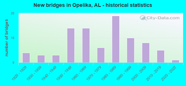
- New bridges - historical statistics
- 41920-1929
- 31930-1939
- 31940-1949
- 141950-1959
- 141960-1969
- 61970-1979
- 191980-1989
- 101990-1999
- 82000-2009
- 52010-2019
- 12020-2022
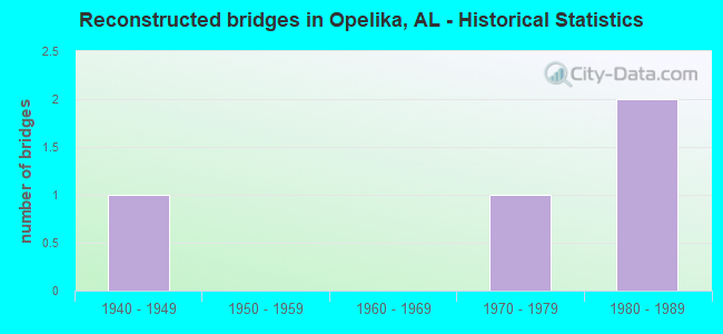
- Reconstructed bridges - Historical Statistics
- 11940-1949
- 01950-1959
- 01960-1969
- 11970-1979
- 21980-1989
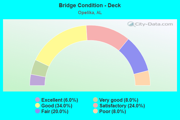
- Bridge Condition - Deck
- 6.0%Excellent
- 8.0%Very good
- 34.0%Good
- 24.0%Satisfactory
- 20.0%Fair
- 8.0%Poor
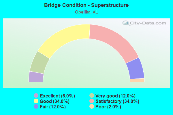
- Bridge Condition - Superstructure
- 6.0%Excellent
- 12.0%Very good
- 34.0%Good
- 34.0%Satisfactory
- 12.0%Fair
- 2.0%Poor
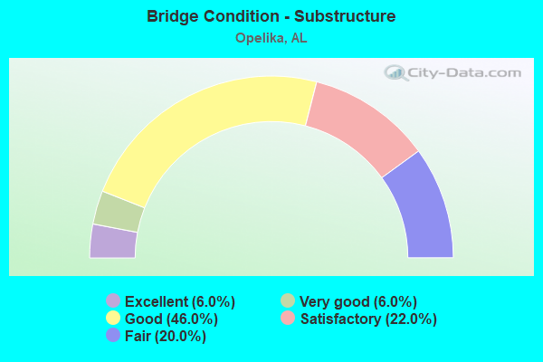
- Bridge Condition - Substructure
- 6.0%Excellent
- 6.0%Very good
- 46.0%Good
- 22.0%Satisfactory
- 20.0%Fair
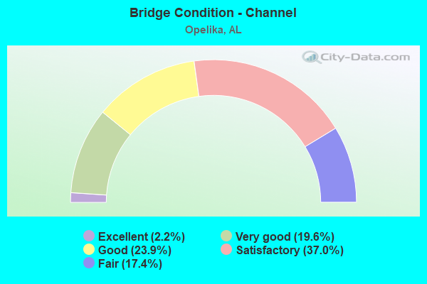
- Bridge Condition - Channel
- 2.2%Excellent
- 19.6%Very good
- 23.9%Good
- 37.0%Satisfactory
- 17.4%Fair
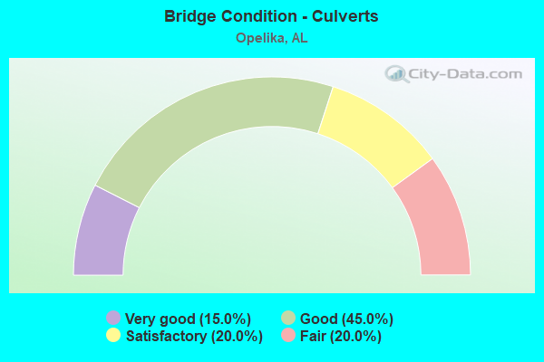
- Bridge Condition - Culverts
- 15.0%Very good
- 45.0%Good
- 20.0%Satisfactory
- 20.0%Fair
Find on map >> Show street view
Structure Number: 14091, Location: 0.8 MI N E JCT S 001 (Lat: 32.643333, Lng: -85.301667), Route carried "on" structure: County highway 1152, Year Built: 1987, Status: Open, Structure Length: 0.67m (2.20ft), Average Daily Traffic: 101 (year 2020), Average Future Daily Traffic: 152 (year 2040), Design Load: HS 20, Features Intersected: HALAWAKEE BRANCH, Facility Carried by Structure: Lee Road 152
Minimum Vertical Clearance: 30+ m (98+ ft), Kilometerpoint: 0.010, Lanes on structure: 2, Owner: County Highway Agency, Approaching Roadway Width: 8.5m (27.9ft), Material/Design: Concrete, Design/Construction: Culvert, Number Of Spans In Main Unit: 2, Length of Maximum Span: 3.0m (9.8ft), Curb-To-Curb Width: 13.5m (44.3ft), Out-to-Out Width: 13.5m (44.3ft)
Condition: Channel: Satisfactory, Culverts: Good, Operating Rating: 88.9 metric tons, Method Used To Determine Operating Rating: Load Factor (LF), Inventory Rating: 74.5 metric tons, Method Used To Determine Inventory Rating: Load Factor (LF), Structural Evaluation: Better than present minimum criteria, Deck Geometry: Superior to present desirable criteria, Waterway Adequacy: Equal to present minimum criteria, Approach Roadway Alignment: Equal to present desirable criteria, Length Of Structure Improvement: 1.30m (4.27ft), Designated Inspection Frequency: Every 24 months, Inspection Date: December 2020, Bridge Improvement Cost: $338,000, Roadway Improvement Cost: $34,000, Total Project Cost: $372,000 ( Estimate for 2022)
Find on map >> Show street view
Structure Number: 14195, Location: 1 MI N JCT AL 15 (Lat: 32.687300, Lng: -85.334600), Route carried "on" structure: City street , Year Built: 1987, Status: Open, Structure Length: 0.98m (3.22ft), Average Daily Traffic: 850 (year 2020), Truck Traffic: 10%, Average Future Daily Traffic: 1,700 (year 2040), Design Load: HS 20, Features Intersected: HALAWAKEE CREEK, Facility Carried by Structure: ANDERSON ROAD
Minimum Vertical Clearance: 30+ m (98+ ft), Kilometerpoint: 0.010, Lanes on structure: 2, Owner: City or Municipal Highway Agency, Approaching Roadway Width: 6.3m (20.7ft), Material/Design: Concrete, Design/Construction: Culvert, Number Of Spans In Main Unit: 3, Length of Maximum Span: 3.0m (9.8ft)
Condition: Channel: Fair, Culverts: Satisfactory, Operating Rating: 64.0 metric tons, Method Used To Determine Operating Rating: Load Factor (LF), Inventory Rating: 38.3 metric tons, Method Used To Determine Inventory Rating: Load Factor (LF), Structural Evaluation: Equal to present minimum criteria, Waterway Adequacy: Better than present minimum criteria, Approach Roadway Alignment: Better than present minimum criteria, Length Of Structure Improvement: 1.65m (5.41ft), Designated Inspection Frequency: Every 24 months, Inspection Date: November 2020, Bridge Improvement Cost: $430,000, Roadway Improvement Cost: $43,000, Total Project Cost: $473,000 ( Estimate for 2022)
Find on map >> Show street view
Structure Number: 1483, Location: JCT US 431 * I-85 (Lat: 32.643722, Lng: -85.352278), Route carried "on" structure: US 431, Year Built: 1989, Status: Open, Structure Length: 8.66m (28.41ft), Average Daily Traffic: 8,530 (year 2013), Truck Traffic: 8%, Average Future Daily Traffic: 11,044 (year 2033), Design Load: HS 20, Features Intersected: I-85
Minimum Vertical Clearance: 30+ m (98+ ft), Kilometerpoint: 221.222, Lanes on structure: 6, Lanes under structure: 6, Base Highway Network: Yes, Owner: State Highway Agency, Approaching Roadway Width: 24.4m (80.1ft), Skew: 3 degrees, Material/Design: Prestressed concrete continuous, Design/Construction: Stringer/Multi-beam, Number Of Spans In Main Unit: 4, Length of Maximum Span: 23.8m (78.1ft), Curb-To-Curb Width: 24.4m (80.1ft), Out-to-Out Width: 25.2m (82.7ft)
Condition: Deck: Satisfactory, Superstructure: Satisfactory, Substructure: Good, Operating Rating: 47.8 metric tons, Method Used To Determine Operating Rating: Load Factor (LF), Inventory Rating: 28.6 metric tons, Method Used To Determine Inventory Rating: Load Factor (LF), Structural Evaluation: Equal to present minimum criteria, Deck Geometry: Meets minimum limits, Underclear: Meets minimum limits, Approach Roadway Alignment: Better than present minimum criteria, Length Of Structure Improvement: 9.64m (31.63ft), Designated Inspection Frequency: Every 24 months, Inspection Date: December 2020, Bridge Improvement Cost: $5,422,000, Roadway Improvement Cost: $542,000, Total Project Cost: $5,964,000 ( Estimate for 2022), Deck Structure Type: Concrete Cast-file-Place
Find on map >> Show street view
Structure Number: 1527, Location: 2.5 MI N JCT CO 44 (Lat: 32.640667, Lng: -85.316667), Route carried "on" structure: US 431, Year Built: 1929, Year Reconstructed: 1991, Status: Open, Structure Length: 0.95m (3.12ft), Average Daily Traffic: 18,080 (year 2013), Truck Traffic: 15%, Average Future Daily Traffic: 23,409 (year 2033), Design Load: HS 20, Features Intersected: BRANCH, Facility Carried by Structure: US 280
Minimum Vertical Clearance: 30+ m (98+ ft), Kilometerpoint: 217.480, Lanes on structure: 5, Base Highway Network: Yes, Owner: State Highway Agency, Approaching Roadway Width: 20.1m (65.9ft), Material/Design: Concrete, Design/Construction: Culvert, Number Of Spans In Main Unit: 3, Length of Maximum Span: 3.0m (9.8ft)
Condition: Channel: Satisfactory, Culverts: Satisfactory, Operating Rating: 77.8 metric tons, Method Used To Determine Operating Rating: Load Factor (LF), Inventory Rating: 46.7 metric tons, Method Used To Determine Inventory Rating: Load Factor (LF), Structural Evaluation: Equal to present minimum criteria, Waterway Adequacy: Superior to present desirable criteria, Approach Roadway Alignment: Equal to present desirable criteria, Length Of Structure Improvement: 1.63m (5.35ft), Designated Inspection Frequency: Every 24 months, Inspection Date: March 2021, Bridge Improvement Cost: $1,090,000, Roadway Improvement Cost: $109,000, Total Project Cost: $1,199,000 ( Estimate for 2022)
Find on map >> Show street view
Structure Number: 15271, Location: TOWN OF OPELIKA (Lat: 32.643222, Lng: -85.345444), Route carried "on" structure: US 431, Year Built: 1929, Year Reconstructed: 1991, Status: Open, Structure Length: 0.94m (3.08ft), Average Daily Traffic: 20,950 (year 2013), Truck Traffic: 10%, Average Future Daily Traffic: 27,125 (year 2033), Design Load: HS 20, Features Intersected: BRANCH, Facility Carried by Structure: US 280
Minimum Vertical Clearance: 30+ m (98+ ft), Kilometerpoint: 220.292, Lanes on structure: 5, Base Highway Network: Yes, Owner: State Highway Agency, Approaching Roadway Width: 20.1m (65.9ft), Material/Design: Concrete, Design/Construction: Culvert, Number Of Spans In Main Unit: 3, Length of Maximum Span: 3.0m (9.8ft)
Condition: Channel: Good, Culverts: Good, Operating Rating: 85.8 metric tons, Method Used To Determine Operating Rating: Load Factor (LF), Inventory Rating: 51.4 metric tons, Method Used To Determine Inventory Rating: Load Factor (LF), Structural Evaluation: Better than present minimum criteria, Waterway Adequacy: Better than present minimum criteria, Approach Roadway Alignment: Equal to present desirable criteria, Length Of Structure Improvement: 1.62m (5.31ft), Designated Inspection Frequency: Every 24 months, Inspection Date: January 2021, Bridge Improvement Cost: $981,000, Roadway Improvement Cost: $98,000, Total Project Cost: $1,079,000 ( Estimate for 2022)
Find on map >> Show street view
Structure Number: 16432, Location: 0.2MI S FREDERICK RD (Lat: 32.616958, Lng: -85.402189), Route carried "on" structure: US 280, Year Built: 1995, Status: Open, Structure Length: 10.30m (33.79ft), Average Daily Traffic: 32,040 (year 2013), Truck Traffic: 5%, Average Future Daily Traffic: 42,144 (year 2033), Design Load: HS 20, Features Intersected: I-85
Minimum Vertical Clearance: 30+ m (98+ ft), Kilometerpoint: 172.956, Lanes on structure: 6, Lanes under structure: 4, Base Highway Network: Yes, Owner: State Highway Agency, Approaching Roadway Width: 31.1m (102.0ft), Material/Design: Prestressed concrete, Design/Construction: Stringer/Multi-beam, Number Of Spans In Main Unit: 4, Length of Maximum Span: 28.3m (92.8ft), Curb-To-Curb Width: 31.1m (102.0ft), Out-to-Out Width: 31.9m (104.7ft)
Condition: Deck: Satisfactory, Superstructure: Good, Substructure: Good, Operating Rating: 81.4 metric tons, Method Used To Determine Operating Rating: Load Factor (LF), Inventory Rating: 46.2 metric tons, Method Used To Determine Inventory Rating: Load Factor (LF), Structural Evaluation: Better than present minimum criteria, Deck Geometry: Superior to present desirable criteria, Underclear: Better than present minimum criteria, Approach Roadway Alignment: Equal to present minimum criteria, Length Of Structure Improvement: 11.22m (36.81ft), Designated Inspection Frequency: Every 24 months, Inspection Date: Febuary 2022, Bridge Improvement Cost: $7,999,000, Roadway Improvement Cost: $800,000, Total Project Cost: $8,799,000 ( Estimate for 2022), Deck Structure Type: Concrete Cast-file-Place
Find on map >> Show street view
Structure Number: 1671, Location: 0.3MI E INT US 29 (Lat: 32.633775, Lng: -85.409308), Route carried "on" structure: US 280, Year Built: 1996, Status: Open, Structure Length: 4.02m (13.19ft), Average Daily Traffic: 32,040 (year 2013), Truck Traffic: 5%, Average Future Daily Traffic: 42,144 (year 2033), Design Load: HS 20, Features Intersected: FIRST AVENUE
Minimum Vertical Clearance: 30+ m (98+ ft), Kilometerpoint: 172.781, Lanes on structure: 4, Lanes under structure: 2, Base Highway Network: Yes, Owner: State Highway Agency, Approaching Roadway Width: 21.3m (69.9ft), Material/Design: Prestressed concrete, Design/Construction: Stringer/Multi-beam, Number Of Spans In Main Unit: 3, Length of Maximum Span: 15.2m (49.9ft), Curb-To-Curb Width: 20.7m (67.9ft), Out-to-Out Width: 21.6m (70.9ft)
Condition: Deck: Satisfactory, Superstructure: Poor, Substructure: Good, Operating Rating: 67.9 metric tons, Method Used To Determine Operating Rating: Load Factor (LF), Inventory Rating: 40.7 metric tons, Method Used To Determine Inventory Rating: Load Factor (LF), Structural Evaluation: Meets minimum limits, Deck Geometry: Equal to present minimum criteria, Underclear: Meets minimum limits, Approach Roadway Alignment: Better than present minimum criteria, Length Of Structure Improvement: 4.98m (16.34ft), Designated Inspection Frequency: Every 24 months, Other Special Inspection Frequency: Every 12 months, Inspection Date: January 2022, Other Special Inspection Date: January 2022, Bridge Improvement Cost: $2,388,000, Roadway Improvement Cost: $239,000, Total Project Cost: $2,627,000 ( Estimate for 2022), Deck Structure Type: Concrete Cast-file-Place
Find on map >> Show street view
Structure Number: 16711, Location: 0.4MI E INT US 29 (Lat: 32.632639, Lng: -85.408981), Route carried "on" structure: US 280, Year Built: 1996, Status: Open, Structure Length: 4.36m (14.30ft), Average Daily Traffic: 32,040 (year 2013), Truck Traffic: 5%, Average Future Daily Traffic: 42,144 (year 2033), Design Load: HS 20, Features Intersected: CSX RAILROAD
Minimum Vertical Clearance: 30+ m (98+ ft), Kilometerpoint: 172.819, Lanes on structure: 4, Base Highway Network: Yes, Owner: State Highway Agency, Approaching Roadway Width: 21.3m (69.9ft), Material/Design: Prestressed concrete, Design/Construction: Stringer/Multi-beam, Number Of Spans In Main Unit: 3, Length of Maximum Span: 16.8m (55.1ft), Curb-To-Curb Width: 20.7m (67.9ft), Out-to-Out Width: 21.6m (70.9ft)
Condition: Deck: Satisfactory, Superstructure: Satisfactory, Substructure: Good, Operating Rating: 70.2 metric tons, Method Used To Determine Operating Rating: Load Factor (LF), Inventory Rating: 42.0 metric tons, Method Used To Determine Inventory Rating: Load Factor (LF), Structural Evaluation: Equal to present minimum criteria, Deck Geometry: Superior to present desirable criteria, Underclear: Superior to present desirable criteria, Approach Roadway Alignment: Better than present minimum criteria, Length Of Structure Improvement: 5.34m (17.52ft), Designated Inspection Frequency: Every 24 months, Inspection Date: June 2021, Bridge Improvement Cost: $2,563,000, Roadway Improvement Cost: $256,000, Total Project Cost: $2,819,000 ( Estimate for 2022), Deck Structure Type: Concrete Cast-file-Place
Find on map >> Show street view
Structure Number: 16933, Location: 1.1 MI. WEST OF I85 (Lat: 32.631953, Lng: -85.408439), Route carried "on" structure: US 38, Year Built: 1996, Status: Open, Structure Length: 1.54m (5.05ft), Average Daily Traffic: 32,040 (year 2013), Truck Traffic: 5%, Average Future Daily Traffic: 42,144 (year 2033), Design Load: HS 20, Features Intersected: PEPPERELL CREEK, Facility Carried by Structure: U.S. 280
Minimum Vertical Clearance: 30+ m (98+ ft), Kilometerpoint: 172.897, Lanes on structure: 4, Base Highway Network: Yes, Owner: State Highway Agency, Approaching Roadway Width: 21.3m (69.9ft), Material/Design: Concrete, Design/Construction: Culvert, Number Of Spans In Main Unit: 4, Length of Maximum Span: 3.7m (12.1ft)
Condition: Channel: Satisfactory, Culverts: Good, Operating Rating: 88.9 metric tons, Method Used To Determine Operating Rating: Load Factor (LF), Inventory Rating: 88.9 metric tons, Method Used To Determine Inventory Rating: Load Factor (LF), Structural Evaluation: Better than present minimum criteria, Waterway Adequacy: Superior to present desirable criteria, Approach Roadway Alignment: Equal to present desirable criteria, Length Of Structure Improvement: 2.22m (7.28ft), Designated Inspection Frequency: Every 24 months, Inspection Date: June 2021, Bridge Improvement Cost: $2,158,000, Roadway Improvement Cost: $216,000, Total Project Cost: $2,374,000 ( Estimate for 2022)
Find on map >> Show street view
Structure Number: 16949, Location: Grand Nat'l Parkway (Lat: 32.651667, Lng: -85.450000), Route carried "on" structure: City street , Year Built: 1996, Status: Open, Structure Length: 3.90m (12.80ft), Average Daily Traffic: 2,000 (year 2022), Truck Traffic: 5%, Average Future Daily Traffic: 2,500 (year 2042), Design Load: HS 20, Features Intersected: SAUGAHATCHEE CREEK, Facility Carried by Structure: GRAND NATIONAL PW
Minimum Vertical Clearance: 30+ m (98+ ft), Kilometerpoint: 0.805, Lanes on structure: 2, Owner: City or Municipal Highway Agency, Approaching Roadway Width: 7.3m (24.0ft), Skew: 3 degrees, Material/Design: Prestressed concrete, Design/Construction: Stringer/Multi-beam, Number Of Spans In Main Unit: 1, Length of Maximum Span: 39.0m (128.0ft), Curb-To-Curb Width: 8.5m (27.9ft), Out-to-Out Width: 9.3m (30.5ft)
Condition: Deck: Very good, Superstructure: Very good, Substructure: Very good, Channel: Very good, Operating Rating: 88.9 metric tons, Method Used To Determine Operating Rating: Load Factor (LF), Inventory Rating: 46.0 metric tons, Method Used To Determine Inventory Rating: Load Factor (LF), Structural Evaluation: Equal to present desirable criteria, Deck Geometry: Somewhat better than minimum adequacy, Waterway Adequacy: Superior to present desirable criteria, Approach Roadway Alignment: Equal to present desirable criteria, Length Of Structure Improvement: 4.85m (15.91ft), Designated Inspection Frequency: Every 24 months, Inspection Date: Febuary 2022, Bridge Improvement Cost: $997,000, Roadway Improvement Cost: $100,000, Total Project Cost: $1,097,000 ( Estimate for 2022), Deck Structure Type: Concrete Cast-file-Place
Find on map >> Show street view
Structure Number: 17074, Location: 2.6MI N INTER US29 * I85 (Lat: 32.700417, Lng: -85.313722), Route carried "on" structure: Spur Other road , Year Built: 2002, Status: Open, Structure Length: 9.40m (30.84ft), Average Daily Traffic: 3,360 (year 2009), Truck Traffic: 22%, Average Future Daily Traffic: 4,704 (year 2032), Design Load: HS 20, Features Intersected: I-85, Facility Carried by Structure: ANDREWS RD(EXIT66)
Minimum Vertical Clearance: 30+ m (98+ ft), Kilometerpoint: 0.000, Lanes on structure: 3, Lanes under structure: 5, Owner: State Highway Agency, Approaching Roadway Width: 11.5m (37.7ft), Skew: 10 degrees, Material/Design: Prestressed concrete, Design/Construction: Stringer/Multi-beam, Number Of Spans In Main Unit: 4, Length of Maximum Span: 32.0m (105.0ft), Curb-To-Curb Width: 15.8m (51.8ft), Out-to-Out Width: 16.7m (54.8ft)
Condition: Deck: Good, Superstructure: Good, Substructure: Good, Operating Rating: 65.2 metric tons, Method Used To Determine Operating Rating: Load Factor (LF), Inventory Rating: 28.1 metric tons, Method Used To Determine Inventory Rating: Load Factor (LF), Structural Evaluation: Better than present minimum criteria, Deck Geometry: Better than present minimum criteria, Underclear: Superior to present desirable criteria, Approach Roadway Alignment: Equal to present desirable criteria, Length Of Structure Improvement: 10.35m (33.96ft), Designated Inspection Frequency: Every 24 months, Inspection Date: September 2020, Bridge Improvement Cost: $3,834,000, Roadway Improvement Cost: $383,000, Total Project Cost: $4,217,000 ( Estimate for 2022), Deck Structure Type: Concrete Cast-file-Place
Find on map >> Show street view
Structure Number: 17075, Location: 2.6 MI N INTER US29 * I85 (Lat: 32.700278, Lng: -85.313806), Route carried "on" structure: Other road , Year Built: 2002, Status: Open, Structure Length: 9.40m (30.84ft), Average Daily Traffic: 3,360 (year 2009), Truck Traffic: 22%, Average Future Daily Traffic: 4,704 (year 2032), Design Load: HS 20, Features Intersected: I-85, Facility Carried by Structure: ANDREWS RD(EXIT66)
Minimum Vertical Clearance: 30+ m (98+ ft), Kilometerpoint: 0.002, Lanes on structure: 2, Lanes under structure: 4, Owner: State Highway Agency, Approaching Roadway Width: 12.0m (39.4ft), Skew: 10 degrees, Material/Design: Prestressed concrete, Design/Construction: Stringer/Multi-beam, Number Of Spans In Main Unit: 4, Length of Maximum Span: 32.0m (105.0ft), Curb-To-Curb Width: 15.8m (51.8ft), Out-to-Out Width: 16.7m (54.8ft)
Condition: Deck: Good, Superstructure: Good, Substructure: Good, Operating Rating: 65.2 metric tons, Method Used To Determine Operating Rating: Load Factor (LF), Inventory Rating: 28.1 metric tons, Method Used To Determine Inventory Rating: Load Factor (LF), Structural Evaluation: Better than present minimum criteria, Deck Geometry: Superior to present desirable criteria, Underclear: Superior to present desirable criteria, Approach Roadway Alignment: Equal to present desirable criteria, Length Of Structure Improvement: 10.35m (33.96ft), Designated Inspection Frequency: Every 24 months, Inspection Date: September 2020, Bridge Improvement Cost: $3,834,000, Roadway Improvement Cost: $383,000, Total Project Cost: $4,217,000 ( Estimate for 2022), Deck Structure Type: Concrete Cast-file-Place
Find on map >> Show street view
Structure Number: 17076, Location: 0.8 MI NE ANDERSON RD. (Lat: 32.690900, Lng: -85.325200), Route carried "on" structure: City street , Year Built: 2002, Status: Open, Structure Length: 1.69m (5.54ft), Average Daily Traffic: 1,000 (year 2022), Truck Traffic: 15%, Average Future Daily Traffic: 1,500 (year 2042), Design Load: HS 20, Features Intersected: STREAM, Facility Carried by Structure: NORTH PARK DRIVE
Minimum Vertical Clearance: 30+ m (98+ ft), Kilometerpoint: 1.287, Lanes on structure: 2, Owner: City or Municipal Highway Agency, Approaching Roadway Width: 7.6m (24.9ft), Skew: 1 degrees, Material/Design: Steel, Design/Construction: Culvert, Number Of Spans In Main Unit: 3, Length of Maximum Span: 4.9m (16.1ft), Curb-To-Curb Width: 8.7m (28.5ft), Out-to-Out Width: 37.0m (121.4ft)
Condition: Channel: Good, Culverts: Good, Operating Rating: 88.9 metric tons, Method Used To Determine Operating Rating: Load Factor (LF), Inventory Rating: 67.1 metric tons, Method Used To Determine Inventory Rating: Load Factor (LF), Structural Evaluation: Better than present minimum criteria, Deck Geometry: Somewhat better than minimum adequacy, Waterway Adequacy: Equal to present desirable criteria, Approach Roadway Alignment: Equal to present desirable criteria, Length Of Structure Improvement: 2.38m (7.81ft), Designated Inspection Frequency: Every 24 months, Inspection Date: January 2022, Bridge Improvement Cost: $1,637,000, Roadway Improvement Cost: $164,000, Total Project Cost: $1,801,000 ( Estimate for 2022)
Find on map >> Show street view
Structure Number: 17077, Location: 0.17MI E OF I85 (Lat: 32.698333, Lng: -85.310000), Route carried "on" structure: City street , Year Built: 2002, Status: Open, Structure Length: 2.09m (6.86ft), Average Daily Traffic: 1,500 (year 2020), Truck Traffic: 1%, Average Future Daily Traffic: 2,000 (year 2040), Design Load: HS 20, Features Intersected: STREAM, Facility Carried by Structure: ANDREWS ROAD
Minimum Vertical Clearance: 30+ m (98+ ft), Kilometerpoint: 0.000, Lanes on structure: 4, Owner: City or Municipal Highway Agency, Approaching Roadway Width: 10.8m (35.4ft), Skew: 13 degrees, Material/Design: Concrete, Design/Construction: Culvert, Number Of Spans In Main Unit: 4, Length of Maximum Span: 4.3m (14.1ft)
Condition: Channel: Good, Culverts: Very good, Operating Rating: 88.9 metric tons, Method Used To Determine Operating Rating: Load Factor (LF), Inventory Rating: 88.9 metric tons, Method Used To Determine Inventory Rating: Load Factor (LF), Structural Evaluation: Equal to present desirable criteria, Waterway Adequacy: Equal to present minimum criteria, Approach Roadway Alignment: Equal to present desirable criteria, Length Of Structure Improvement: 2.86m (9.38ft), Designated Inspection Frequency: Every 24 months, Inspection Date: November 2020, Bridge Improvement Cost: $5,209,000, Roadway Improvement Cost: $521,000, Total Project Cost: $5,730,000 ( Estimate for 2022)
Find on map >> Show street view
Structure Number: 17216, Location: 2nd Ave RR (Lat: 32.014694, Lng: -85.400833), Route carried "on" structure: City street 14, Year Built: 1998, Status: Open, Structure Length: 8.60m (28.22ft), Average Daily Traffic: 18,979 (year 2022), Truck Traffic: 8%, Average Future Daily Traffic: 26,257 (year 2042), Design Load: HS 20, Features Intersected: NO. SOUTHERN RAILROAD, Facility Carried by Structure: 2ND AVE OPELIKA
Minimum Vertical Clearance: 30+ m (98+ ft), Kilometerpoint: 364.471, Lanes on structure: 2, Owner: City or Municipal Highway Agency, Approaching Roadway Width: 14.6m (47.9ft), Skew: 2 degrees, Material/Design: Steel continuous, Design/Construction: Stringer/Multi-beam, Number Of Spans In Main Unit: 2, Length of Maximum Span: 43.0m (141.1ft), Curb or Sidewalk Widths: Left: 1.4m (4.6ft), Right: 1.4m (4.6ft), Curb-To-Curb Width: 15.8m (51.8ft), Out-to-Out Width: 19.4m (63.6ft)
Condition: Deck: Very good, Superstructure: Very good, Substructure: Very good, Operating Rating: 77.1 metric tons, Method Used To Determine Operating Rating: Load Factor (LF), Inventory Rating: 46.2 metric tons, Method Used To Determine Inventory Rating: Load Factor (LF), Structural Evaluation: Equal to present desirable criteria, Deck Geometry: Superior to present desirable criteria, Underclear: Equal to present minimum criteria, Approach Roadway Alignment: Equal to present desirable criteria, Length Of Structure Improvement: 9.58m (31.43ft), Designated Inspection Frequency: Every 24 months, Inspection Date: Febuary 2022, Bridge Improvement Cost: $4,139,000, Roadway Improvement Cost: $414,000, Total Project Cost: $4,553,000 ( Estimate for 2022), Deck Structure Type: Concrete Cast-file-Place
Find on map >> Show street view
Structure Number: 19634, Location: Dunlop Drive (Lat: 32.642083, Lng: -85.410028), Route carried "on" structure: City street , Year Built: 2005, Status: Open, Structure Length: 5.49m (18.01ft), Average Daily Traffic: 4,000 (year 2021), Average Future Daily Traffic: 8,000 (year 2041), Design Load: HS 20, Features Intersected: NS RAILROAD, Facility Carried by Structure: DUNLOP DRIVE
Minimum Vertical Clearance: 30+ m (98+ ft), Kilometerpoint: 0.209, Lanes on structure: 2, Owner: City or Municipal Highway Agency, Approaching Roadway Width: 9.8m (32.2ft), Skew: 1 degrees, Material/Design: Prestressed concrete, Design/Construction: Stringer/Multi-beam, Number Of Spans In Main Unit: 3, Length of Maximum Span: 24.4m (80.1ft), Curb-To-Curb Width: 10.7m (35.1ft), Out-to-Out Width: 11.6m (38.1ft)
Condition: Deck: Very good, Superstructure: Very good, Substructure: Very good, Operating Rating: 68.4 metric tons, Method Used To Determine Operating Rating: Load Factor (LF), Inventory Rating: 44.7 metric tons, Method Used To Determine Inventory Rating: Load Factor (LF), Structural Evaluation: Equal to present desirable criteria, Deck Geometry: Somewhat better than minimum adequacy, Underclear: Superior to present desirable criteria, Approach Roadway Alignment: Superior to present desirable criteria, Length Of Structure Improvement: 6.52m (21.39ft), Designated Inspection Frequency: Every 24 months, Inspection Date: November 2021, Bridge Improvement Cost: $1,654,000, Roadway Improvement Cost: $165,000, Total Project Cost: $1,819,000 ( Estimate for 2022), Deck Structure Type: Concrete Cast-file-Place
Find on map >> Show street view
Structure Number: 19677, Location: 7.5 MI N JCT I85 (Lat: 32.734000, Lng: -85.232389), Route carried "on" structure: US 29, Year Built: 2010, Status: Open, Structure Length: 0.94m (3.08ft), Average Daily Traffic: 2,790 (year 2013), Truck Traffic: 7%, Average Future Daily Traffic: 3,802 (year 2033), Design Load: HS 20, Features Intersected: BRANCH
Minimum Vertical Clearance: 30+ m (98+ ft), Kilometerpoint: 322.643, Lanes on structure: 2, Base Highway Network: Yes, Owner: State Highway Agency, Approaching Roadway Width: 9.9m (32.5ft), Skew: 4 degrees, Material/Design: Concrete, Design/Construction: Culvert, Number Of Spans In Main Unit: 2, Length of Maximum Span: 4.7m (15.4ft)
Condition: Channel: Good, Culverts: Satisfactory, Operating Rating: 88.9 metric tons, Method Used To Determine Operating Rating: Load Factor (LF), Inventory Rating: 88.9 metric tons, Method Used To Determine Inventory Rating: Load Factor (LF), Structural Evaluation: Equal to present minimum criteria, Waterway Adequacy: Better than present minimum criteria, Approach Roadway Alignment: Better than present minimum criteria, Length Of Structure Improvement: 1.61m (5.28ft), Designated Inspection Frequency: Every 24 months, Inspection Date: January 2021, Bridge Improvement Cost: $1,346,000, Roadway Improvement Cost: $135,000, Total Project Cost: $1,481,000 ( Estimate for 2022)
Find on map >> Show street view
Structure Number: 19793, Location: 4.2 MI. N JCT I85 (Lat: 32.697417, Lng: -85.267306), Route carried "on" structure: US 29, Year Built: 2011, Status: Open, Structure Length: 5.18m (16.99ft), Average Daily Traffic: 5,880 (year 2013), Truck Traffic: 6%, Average Future Daily Traffic: 8,014 (year 2033), Design Load: HS 20, Features Intersected: HALAWAKEE CREEK
Minimum Vertical Clearance: 30+ m (98+ ft), Kilometerpoint: 317.279, Lanes on structure: 2, Base Highway Network: Yes, Owner: State Highway Agency, Approaching Roadway Width: 10.1m (33.1ft), Material/Design: Steel continuous, Design/Construction: Stringer/Multi-beam, Number Of Spans In Main Unit: 3, Length of Maximum Span: 18.3m (60.0ft), Curb-To-Curb Width: 12.2m (40.0ft), Out-to-Out Width: 13.0m (42.7ft)
Condition: Deck: Good, Superstructure: Very good, Substructure: Good, Channel: Satisfactory, Operating Rating: 51.8 metric tons, Method Used To Determine Operating Rating: Load Factor (LF), Inventory Rating: 31.0 metric tons, Method Used To Determine Inventory Rating: Load Factor (LF), Structural Evaluation: Better than present minimum criteria, Deck Geometry: Somewhat better than minimum adequacy, Waterway Adequacy: Equal to present minimum criteria, Approach Roadway Alignment: Equal to present desirable criteria, Length Of Structure Improvement: 6.21m (20.37ft), Designated Inspection Frequency: Every 24 months, Underwater Inspection Frequency: Every 24 months, Inspection Date: Febuary 2021, Underwater Inspection Date: Febuary 2021, Bridge Improvement Cost: $1,787,000, Roadway Improvement Cost: $179,000, Total Project Cost: $1,966,000 ( Estimate for 2022), Deck Structure Type: Concrete Cast-file-Place
Find on map >> Show street view
Structure Number: 19843, Location: WHITE ROAD (Lat: 32.133333, Lng: -85.450000), Route carried "on" structure: City street , Year Built: 2005, Status: Open, Structure Length: 1.22m (4.00ft), Average Daily Traffic: 30 (year 2020), Average Future Daily Traffic: 42 (year 2040), Design Load: HS 20, Features Intersected: ROCKY CREEK, Facility Carried by Structure: WHITE ROAD
Minimum Vertical Clearance: 30+ m (98+ ft), Kilometerpoint: 0.800, Lanes on structure: 2, Owner: City or Municipal Highway Agency, Approaching Roadway Width: 5.5m (18.0ft), Material/Design: Concrete, Design/Construction: Channel Beam, Number Of Spans In Main Unit: 1, Length of Maximum Span: 12.2m (40.0ft), Curb-To-Curb Width: 8.5m (27.9ft), Out-to-Out Width: 9.3m (30.5ft)
Condition: Deck: Excellent, Superstructure: Excellent, Substructure: Excellent, Channel: Excellent, Operating Rating: 59.3 metric tons, Method Used To Determine Operating Rating: Load Factor (LF), Inventory Rating: 37.1 metric tons, Method Used To Determine Inventory Rating: Load Factor (LF), Structural Evaluation: Superior to present desirable criteria, Deck Geometry: Better than present minimum criteria, Waterway Adequacy: Equal to present desirable criteria, Approach Roadway Alignment: Better than present minimum criteria, Length Of Structure Improvement: 1.89m (6.20ft), Designated Inspection Frequency: Every 24 months, Inspection Date: November 2020, Bridge Improvement Cost: $389,000, Roadway Improvement Cost: $39,000, Total Project Cost: $428,000 ( Estimate for 2022), Deck Structure Type: Concrete Precast Panels
Find on map >> Show street view
Structure Number: 20026, Location: 0.2 MI N US 280 (Lat: 32.616667, Lng: -85.400000), Route carried "on" structure: City street , Year Built: 1981, Status: Open, Structure Length: 0.71m (2.33ft), Average Daily Traffic: 2,000 (year 2021), Average Future Daily Traffic: 4,000 (year 2041), Design Load: HS 20, Features Intersected: STREAM, Facility Carried by Structure: THOMASVILLE DR.
Minimum Vertical Clearance: 30+ m (98+ ft), Kilometerpoint: 0.322, Lanes on structure: 2, Owner: City or Municipal Highway Agency, Approaching Roadway Width: 14.8m (48.6ft), Material/Design: Concrete, Design/Construction: Channel Beam, Number Of Spans In Main Unit: 1, Length of Maximum Span: 7.1m (23.3ft), Curb-To-Curb Width: 15.7m (51.5ft), Out-to-Out Width: 16.0m (52.5ft)
Condition: Deck: Good, Superstructure: Satisfactory, Substructure: Satisfactory, Channel: Satisfactory, Operating Rating: 62.7 metric tons, Method Used To Determine Operating Rating: Load Factor (LF), Inventory Rating: 37.6 metric tons, Method Used To Determine Inventory Rating: Load Factor (LF), Structural Evaluation: Equal to present minimum criteria, Deck Geometry: Superior to present desirable criteria, Waterway Adequacy: Better than present minimum criteria, Approach Roadway Alignment: Equal to present desirable criteria, Length Of Structure Improvement: 1.34m (4.40ft), Designated Inspection Frequency: Every 24 months, Inspection Date: November 2021, Bridge Improvement Cost: $479,000, Roadway Improvement Cost: $48,000, Total Project Cost: $527,000 ( Estimate for 2022), Deck Structure Type: Concrete Precast Panels
Find on map >> Show street view
Structure Number: 20027, Location: WAVERLY PARKWAY (Lat: 33.650000, Lng: -85.433333), Route carried "on" structure: City street , Year Built: 1940, Status: Open, Structure Length: 1.14m (3.74ft), Average Daily Traffic: 2,000 (year 2020), Average Future Daily Traffic: 4,000 (year 2040), Design Load: HS 20, Features Intersected: CREEK, Facility Carried by Structure: WAVERLY PKWY
Minimum Vertical Clearance: 30+ m (98+ ft), Kilometerpoint: 0.002, Lanes on structure: 2, Owner: City or Municipal Highway Agency, Approaching Roadway Width: 7.3m (24.0ft), Material/Design: Concrete, Design/Construction: Culvert, Number Of Spans In Main Unit: 3, Length of Maximum Span: 3.7m (12.1ft), Curb-To-Curb Width: 12.5m (41.0ft), Out-to-Out Width: 13.3m (43.6ft)
Condition: Channel: Satisfactory, Culverts: Satisfactory, Operating Rating: 73.6 metric tons, Method Used To Determine Operating Rating: Load Factor (LF), Inventory Rating: 44.1 metric tons, Method Used To Determine Inventory Rating: Load Factor (LF), Structural Evaluation: Equal to present minimum criteria, Deck Geometry: Better than present minimum criteria, Waterway Adequacy: Better than present minimum criteria, Approach Roadway Alignment: Better than present minimum criteria, Length Of Structure Improvement: 1.82m (5.97ft), Designated Inspection Frequency: Every 24 months, Inspection Date: November 2020, Bridge Improvement Cost: $798,000, Roadway Improvement Cost: $80,000, Total Project Cost: $878,000 ( Estimate for 2022)
Find on map >> Show street view
Structure Number: 20188, Location: 10th Street (Lat: 32.014694, Lng: -85.400833), Route carried "on" structure: City street , Year Built: 1979, Status: Open, Structure Length: 18.66m (61.22ft), Average Daily Traffic: 20,000 (year 2022), Truck Traffic: 5%, Average Future Daily Traffic: 21,000 (year 2042), Design Load: HS 20, Features Intersected: W RLWY. OF AL, Facility Carried by Structure: 10TH ST.
Minimum Vertical Clearance: 30+ m (98+ ft), Kilometerpoint: 0.002, Lanes on structure: 2, Lanes under structure: 4, Owner: City or Municipal Highway Agency, Approaching Roadway Width: 14.9m (48.9ft), Material/Design: Steel, Design/Construction: Stringer/Multi-beam, Number Of Spans In Main Unit: 7, Length of Maximum Span: 89.0m (292.0ft), Curb or Sidewalk Widths: Left: 1.5m (4.9ft), Right: 1.5m (4.9ft), Curb-To-Curb Width: 15.8m (51.8ft), Out-to-Out Width: 19.6m (64.3ft)
Condition: Deck: Good, Superstructure: Good, Substructure: Good, Operating Rating: 60.8 metric tons, Method Used To Determine Operating Rating: Load Factor (LF), Inventory Rating: 36.4 metric tons, Method Used To Determine Inventory Rating: Load Factor (LF), Structural Evaluation: Better than present minimum criteria, Deck Geometry: Superior to present desirable criteria, Underclear: Superior to present desirable criteria, Approach Roadway Alignment: Equal to present minimum criteria, Length Of Structure Improvement: 19.30m (63.32ft), Designated Inspection Frequency: Every 24 months, Inspection Date: Febuary 2022, Bridge Improvement Cost: $8,470,000, Roadway Improvement Cost: $847,000, Total Project Cost: $9,317,000 ( Estimate for 2022), Deck Structure Type: Concrete Cast-file-Place
Find on map >> Show street view
Structure Number: 20451, Location: FOX RUN (Lat: 32.657222, Lng: -85.351111), Route carried "on" structure: City street , Year Built: 1990, Status: Open, Structure Length: 0.73m (2.40ft), Average Daily Traffic: 3,000 (year 2020), Average Future Daily Traffic: 4,200 (year 2040), Design Load: HS 20, Features Intersected: GRANDBERRY CK, TRIB., Facility Carried by Structure: FOX RUN AVE.
Minimum Vertical Clearance: 30+ m (98+ ft), Kilometerpoint: 1.143, Lanes on structure: 2, Owner: City or Municipal Highway Agency, Approaching Roadway Width: 8.9m (29.2ft), Material/Design: Concrete, Design/Construction: Channel Beam, Number Of Spans In Main Unit: 1, Length of Maximum Span: 7.3m (24.0ft), Curb or Sidewalk Widths: Left: 0.2m (0.7ft), Right: 0.2m (0.7ft), Curb-To-Curb Width: 9.8m (32.2ft), Out-to-Out Width: 10.3m (33.8ft)
Condition: Deck: Good, Superstructure: Good, Substructure: Fair, Channel: Very good, Operating Rating: 52.8 metric tons, Method Used To Determine Operating Rating: Load Factor (LF), Inventory Rating: 31.7 metric tons, Method Used To Determine Inventory Rating: Load Factor (LF), Structural Evaluation: Somewhat better than minimum adequacy, Deck Geometry: Meets minimum limits, Waterway Adequacy: Superior to present desirable criteria, Approach Roadway Alignment: Better than present minimum criteria, Length Of Structure Improvement: 1.38m (4.53ft), Designated Inspection Frequency: Every 24 months, Inspection Date: November 2020, Bridge Improvement Cost: $311,000, Roadway Improvement Cost: $31,000, Total Project Cost: $342,000 ( Estimate for 2022), Deck Structure Type: Concrete Precast Panels
Find on map >> Show street view
Structure Number: 20452, Location: FOX RUN (Lat: 32.650000, Lng: -85.333333), Route carried "on" structure: City street , Year Built: 1987, Status: Open, Structure Length: 0.75m (2.46ft), Average Daily Traffic: 3,000 (year 2020), Average Future Daily Traffic: 4,200 (year 2040), Design Load: HS 20, Features Intersected: GRANDBERRY CK. TRIB., Facility Carried by Structure: FOX RUN AVE.
Minimum Vertical Clearance: 30+ m (98+ ft), Kilometerpoint: 1.609, Lanes on structure: 2, Owner: City or Municipal Highway Agency, Approaching Roadway Width: 11.3m (37.1ft), Skew: 5 degrees, Material/Design: Concrete, Design/Construction: Channel Beam, Number Of Spans In Main Unit: 1, Length of Maximum Span: 7.5m (24.6ft), Curb-To-Curb Width: 12.3m (40.4ft), Out-to-Out Width: 13.1m (43.0ft)
Condition: Deck: Good, Superstructure: Good, Substructure: Fair, Channel: Very good, Operating Rating: 52.8 metric tons, Method Used To Determine Operating Rating: Load Factor (LF), Inventory Rating: 31.7 metric tons, Method Used To Determine Inventory Rating: Load Factor (LF), Structural Evaluation: Somewhat better than minimum adequacy, Deck Geometry: Equal to present minimum criteria, Waterway Adequacy: Superior to present desirable criteria, Approach Roadway Alignment: Better than present minimum criteria, Length Of Structure Improvement: 1.40m (4.59ft), Designated Inspection Frequency: Every 24 months, Inspection Date: November 2020, Bridge Improvement Cost: $414,000, Roadway Improvement Cost: $41,000, Total Project Cost: $455,000 ( Estimate for 2022), Deck Structure Type: Concrete Precast Panels
Find on map >> Show street view
Structure Number: 20453, Location: JETER AVE (Lat: 32.650000, Lng: -85.333333), Route carried "on" structure: City street , Year Built: 1987, Status: Open, Structure Length: 0.73m (2.40ft), Average Daily Traffic: 3,000 (year 2020), Average Future Daily Traffic: 4,200 (year 2040), Design Load: HS 20, Features Intersected: GRANDBERRY CK. TRIB., Facility Carried by Structure: JETER AVE
Minimum Vertical Clearance: 30+ m (98+ ft), Kilometerpoint: 2.012, Lanes on structure: 2, Owner: City or Municipal Highway Agency, Approaching Roadway Width: 11.4m (37.4ft), Material/Design: Concrete, Design/Construction: Channel Beam, Number Of Spans In Main Unit: 1, Length of Maximum Span: 7.3m (24.0ft), Curb-To-Curb Width: 12.3m (40.4ft), Out-to-Out Width: 13.1m (43.0ft)
Condition: Deck: Good, Superstructure: Good, Substructure: Good, Channel: Very good, Operating Rating: 52.8 metric tons, Method Used To Determine Operating Rating: Load Factor (LF), Inventory Rating: 31.7 metric tons, Method Used To Determine Inventory Rating: Load Factor (LF), Structural Evaluation: Better than present minimum criteria, Deck Geometry: Equal to present minimum criteria, Waterway Adequacy: Equal to present desirable criteria, Approach Roadway Alignment: Equal to present desirable criteria, Length Of Structure Improvement: 1.38m (4.53ft), Designated Inspection Frequency: Every 24 months, Inspection Date: November 2020, Bridge Improvement Cost: $406,000, Roadway Improvement Cost: $41,000, Total Project Cost: $447,000 ( Estimate for 2022), Deck Structure Type: Concrete Precast Panels
Find on map >> Show street view
Structure Number: 20454, Location: JETER AVE (Lat: 32.650000, Lng: -85.350000), Route carried "on" structure: City street , Year Built: 1987, Status: Open, Structure Length: 0.73m (2.40ft), Average Daily Traffic: 3,000 (year 2020), Average Future Daily Traffic: 4,200 (year 2040), Design Load: HS 20, Features Intersected: GRANDBERRY CK. TRIB., Facility Carried by Structure: JETER AVE.
Minimum Vertical Clearance: 30+ m (98+ ft), Kilometerpoint: 2.221, Lanes on structure: 2, Owner: City or Municipal Highway Agency, Approaching Roadway Width: 11.4m (37.4ft), Material/Design: Concrete, Design/Construction: Channel Beam, Number Of Spans In Main Unit: 1, Length of Maximum Span: 7.3m (24.0ft), Curb-To-Curb Width: 12.3m (40.4ft), Out-to-Out Width: 13.1m (43.0ft)
Condition: Deck: Good, Superstructure: Good, Substructure: Good, Channel: Very good, Operating Rating: 52.8 metric tons, Method Used To Determine Operating Rating: Load Factor (LF), Inventory Rating: 31.7 metric tons, Method Used To Determine Inventory Rating: Load Factor (LF), Structural Evaluation: Better than present minimum criteria, Deck Geometry: Equal to present minimum criteria, Waterway Adequacy: Equal to present desirable criteria, Approach Roadway Alignment: Equal to present desirable criteria, Length Of Structure Improvement: 1.38m (4.53ft), Designated Inspection Frequency: Every 24 months, Inspection Date: November 2020, Bridge Improvement Cost: $406,000, Roadway Improvement Cost: $41,000, Total Project Cost: $447,000 ( Estimate for 2022), Deck Structure Type: Concrete Precast Panels
Find on map >> Show street view
Structure Number: 20455, Location: FOX TRAIL (Lat: 32.650000, Lng: -85.350000), Route carried "on" structure: City street , Year Built: 1990, Status: Open, Structure Length: 0.73m (2.40ft), Average Daily Traffic: 3,000 (year 2020), Average Future Daily Traffic: 4,200 (year 2040), Design Load: HS 20, Features Intersected: GRANDBERRY CK. TRIB., Facility Carried by Structure: FOX TRAIL
Minimum Vertical Clearance: 30+ m (98+ ft), Kilometerpoint: 1.867, Lanes on structure: 2, Owner: City or Municipal Highway Agency, Approaching Roadway Width: 11.0m (36.1ft), Material/Design: Concrete, Design/Construction: Channel Beam, Number Of Spans In Main Unit: 1, Length of Maximum Span: 7.3m (24.0ft), Curb or Sidewalk Widths: Left: 0.2m (0.7ft), Right: 0.2m (0.7ft), Curb-To-Curb Width: 11.9m (39.0ft), Out-to-Out Width: 12.4m (40.7ft)
Condition: Deck: Good, Superstructure: Good, Substructure: Good, Channel: Very good, Operating Rating: 52.8 metric tons, Method Used To Determine Operating Rating: Load Factor (LF), Inventory Rating: 31.7 metric tons, Method Used To Determine Inventory Rating: Load Factor (LF), Structural Evaluation: Better than present minimum criteria, Deck Geometry: Somewhat better than minimum adequacy, Waterway Adequacy: Equal to present desirable criteria, Approach Roadway Alignment: Equal to present desirable criteria, Length Of Structure Improvement: 1.38m (4.53ft), Designated Inspection Frequency: Every 24 months, Inspection Date: November 2020, Bridge Improvement Cost: $378,000, Roadway Improvement Cost: $38,000, Total Project Cost: $416,000 ( Estimate for 2022), Deck Structure Type: Concrete Precast Panels
Find on map >> Show street view
Structure Number: 21001, Location: 0.2 mi w jctLee Road 158 (Lat: 32.651675, Lng: -85.280831), Route carried "on" structure: County highway 1156, Year Built: 2016, Status: Open, Structure Length: 0.98m (3.22ft), Average Daily Traffic: 113 (year 2020), Truck Traffic: 20%, Average Future Daily Traffic: 170 (year 2040), Design Load: HS 20, Features Intersected: trib to halawakee creek, Facility Carried by Structure: Lee Road 156
Minimum Vertical Clearance: 30+ m (98+ ft), Kilometerpoint: 0.010, Lanes on structure: 2, Owner: County Highway Agency, Approaching Roadway Width: 8.5m (27.9ft), Skew: 1 degrees, Material/Design: Concrete, Design/Construction: Culvert, Number Of Spans In Main Unit: 3, Length of Maximum Span: 3.0m (9.8ft)
Condition: Channel: Good, Culverts: Very good, Operating Rating: 88.9 metric tons, Method Used To Determine Operating Rating: Load Factor (LF), Inventory Rating: 72.6 metric tons, Method Used To Determine Inventory Rating: Load Factor (LF), Structural Evaluation: Equal to present desirable criteria, Waterway Adequacy: Better than present minimum criteria, Approach Roadway Alignment: Better than present minimum criteria, Length Of Structure Improvement: 1.65m (5.41ft), Designated Inspection Frequency: Every 24 months, Inspection Date: October 2020, Bridge Improvement Cost: $476,000, Roadway Improvement Cost: $48,000, Total Project Cost: $524,000 ( Estimate for 2022)
Find on map >> Show street view
Structure Number: 21038, Location: 1.2 Mi SC Jct CR 46 (Lat: 32.661667, Lng: -85.396667), Route carried "on" structure: City street , Year Built: 2015, Status: Open, Structure Length: 1.83m (6.00ft), Average Daily Traffic: 2,150 (year 2021), Truck Traffic: 5%, Average Future Daily Traffic: 5,000 (year 2041), Design Load: HS 20, Features Intersected: Rocky Branch, Facility Carried by Structure: Oak Bowery Road
Minimum Vertical Clearance: 30+ m (98+ ft), Kilometerpoint: 0.010, Lanes on structure: 2, Owner: City or Municipal Highway Agency, Approaching Roadway Width: 7.3m (24.0ft), Material/Design: Prestressed concrete, Design/Construction: Stringer/Multi-beam, Number Of Spans In Main Unit: 1, Length of Maximum Span: 18.3m (60.0ft), Curb-To-Curb Width: 7.3m (24.0ft), Out-to-Out Width: 9.4m (30.8ft)
Condition: Deck: Excellent, Superstructure: Excellent, Substructure: Excellent, Channel: Very good, Operating Rating: 82.8 metric tons, Method Used To Determine Operating Rating: Load Factor (LF), Inventory Rating: 49.6 metric tons, Method Used To Determine Inventory Rating: Load Factor (LF), Structural Evaluation: Superior to present desirable criteria, Deck Geometry: High priority of replacement, Approach Roadway Alignment: Equal to present minimum criteria, Length Of Structure Improvement: 2.54m (8.33ft), Designated Inspection Frequency: Every 24 months, Inspection Date: October 2021, Bridge Improvement Cost: $523,000, Roadway Improvement Cost: $52,000, Total Project Cost: $575,000 ( Estimate for 2022), Deck Structure Type: Concrete Cast-file-Place
Find on map >> Show street view
Structure Number: 21039, Location: Opelika (Lat: 32.629400, Lng: -85.419400), Route carried "on" structure: City street , Year Built: 2018, Status: Open, Structure Length: 3.66m (12.01ft), Average Daily Traffic: 1,650 (year 2021), Average Future Daily Traffic: 2,500 (year 2041), Features Intersected: Pepperell Creek, Facility Carried by Structure: Cunningham Dr.
Minimum Vertical Clearance: 0.00m, Kilometerpoint: 0.698, Lanes on structure: 2, Owner: City or Municipal Highway Agency, Approaching Roadway Width: 7.3m (24.0ft), Material/Design: Prestressed concrete, Design/Construction: Stringer/Multi-beam, Number Of Spans In Main Unit: 3, Length of Maximum Span: 12.2m (40.0ft), Curb-To-Curb Width: 7.3m (24.0ft), Out-to-Out Width: 13.0m (42.7ft)
Condition: Deck: Excellent, Superstructure: Excellent, Substructure: Excellent, Channel: Very good, Operating Rating: 72.0 metric tons, Method Used To Determine Operating Rating: Load Factor (LF), Inventory Rating: 43.2 metric tons, Method Used To Determine Inventory Rating: Load Factor (LF), Structural Evaluation: Superior to present desirable criteria, Deck Geometry: High priority of corrective action, Approach Roadway Alignment: Equal to present minimum criteria, Length Of Structure Improvement: 4.58m (15.03ft), Designated Inspection Frequency: Every 24 months, Inspection Date: May 2021, Bridge Improvement Cost: $1,318,000, Roadway Improvement Cost: $132,000, Total Project Cost: $1,450,000 ( Estimate for 2022), Deck Structure Type: Concrete Cast-file-Place
Find on map >> Show street view
Structure Number: 21391, Location: 1 MI SOUTH OF AL 169 (Lat: 32.610503, Lng: -85.371472), Route carried "on" structure: State highway 51, Year Built: 2020, Status: Open, Structure Length: 1.48m (4.86ft), Average Daily Traffic: 9,280 (year 2019), Truck Traffic: 5%, Average Future Daily Traffic: 13,780 (year 2039), Design Load: HS 20, Features Intersected: ROBINSON CREEK
Minimum Vertical Clearance: 30+ m (98+ ft), Kilometerpoint: 181.592, Lanes on structure: 2, Base Highway Network: Yes, Owner: State Highway Agency, Approaching Roadway Width: 7.3m (24.0ft), Skew: 5 degrees, Material/Design: Concrete, Design/Construction: Culvert, Number Of Spans In Main Unit: 3, Length of Maximum Span: 3.0m (9.8ft)
Condition: Channel: Very good, Culverts: Good, Operating Rating: 88.9 metric tons, Method Used To Determine Operating Rating: Load Factor (LF), Inventory Rating: 56.6 metric tons, Method Used To Determine Inventory Rating: Load Factor (LF), Structural Evaluation: Better than present minimum criteria, Waterway Adequacy: Equal to present desirable criteria, Approach Roadway Alignment: Better than present minimum criteria, Length Of Structure Improvement: 2.15m (7.05ft), Designated Inspection Frequency: Every 24 months, Inspection Date: March 2021, Bridge Improvement Cost: $2,363,000, Roadway Improvement Cost: $236,000, Total Project Cost: $2,599,000 ( Estimate for 2022)
Find on map >> Show street view
Structure Number: 459, Location: 0.8 MI ENE OF US 280 (Lat: 32.655000, Lng: -85.425000), Route carried "under" structure: City street 6, Year Built: 1928, Structure Length: 0. m, Average Daily Traffic: 1,000 (year 1989), Truck Traffic: 1%, Features Intersected: CITY STREET, Facility Carried by Structure: C OF GA RR
Minimum Vertical Clearance: 4.32m (14.17ft), Kilometerpoint: 0.800, Lanes under structure: 2, Material/Design: Concrete, Design/Construction: Slab, Length of Maximum Span: 8.5m (27.9ft)
Find on map >> Show street view
Structure Number: 4392, Location: CITY OF OPELIKA (Lat: 32.626667, Lng: -85.371417), Route carried "under" structure: State highway 51, Year Built: 1952, Structure Length: 0. m, Average Daily Traffic: 15,350 (year 2013), Truck Traffic: 5%, Features Intersected: SR 51, Facility Carried by Structure: C OF GA RAILROAD
Minimum Vertical Clearance: 4.27m (14.01ft), Kilometerpoint: 183.209, Lanes under structure: 2, Material/Design: Steel, Design/Construction: Stringer/Multi-beam, Length of Maximum Span: 12.2m (40.0ft)
Find on map >> Show street view
Structure Number: 6104, Location: 1.4 MI N AIRPORT ROAD (Lat: 32.614472, Lng: -85.407164), Route carried "under" structure: Interstate 85, Year Built: 1958, Structure Length: 0. m, Average Daily Traffic: 39,900 (year 2013), Truck Traffic: 21%, Features Intersected: I-85, Facility Carried by Structure: HAMILTON ROAD
Minimum Vertical Clearance: 5.51m (18.08ft), Kilometerpoint: 93.960, Lanes on structure: 2, Lanes under structure: 4, Material/Design: Concrete continuous, Design/Construction: Tee Beam, Length of Maximum Span: 29.3m (96.1ft)
Find on map >> Show street view
Structure Number: 6495, Location: JCT LONG ST * I-85 (Lat: 32.623556, Lng: -85.387944), Route carried "under" structure: City street , Year Built: 1959, Structure Length: 0. m, Average Daily Traffic: 1,000 (year 1994), Truck Traffic: 1%, Features Intersected: LONG ST, Facility Carried by Structure: I-85
Minimum Vertical Clearance: 5.05m (16.57ft), Kilometerpoint: 59.608, Lanes on structure: 2, Lanes under structure: 2, Material/Design: Concrete continuous, Design/Construction: Tee Beam, Length of Maximum Span: 22.3m (73.2ft)
Find on map >> Show street view
Structure Number: 6496, Location: JCT LONG ST * I-85 (Lat: 32.623833, Lng: -85.388028), Route carried "under" structure: City street , Year Built: 1959, Structure Length: 0. m, Average Daily Traffic: 1,000 (year 1994), Truck Traffic: 1%, Features Intersected: LONG ST, Facility Carried by Structure: I-85
Minimum Vertical Clearance: 5.00m (16.40ft), Kilometerpoint: 59.608, Lanes on structure: 2, Lanes under structure: 3, Material/Design: Concrete continuous, Design/Construction: Tee Beam, Length of Maximum Span: 22.3m (73.2ft)
Find on map >> Show street view
Structure Number: 6499, Location: JCT SR 51 * I-85 (Lat: 32.631778, Lng: -85.372556), Route carried "under" structure: State highway 51, Year Built: 1959, Structure Length: 0. m, Average Daily Traffic: 1,220 (year 2013), Truck Traffic: 13%, Features Intersected: SR 51, Facility Carried by Structure: I-85
Minimum Vertical Clearance: 4.80m (15.75ft), Kilometerpoint: 45.672, Lanes on structure: 2, Lanes under structure: 4, Material/Design: Concrete continuous, Design/Construction: Tee Beam, Length of Maximum Span: 20.7m (67.9ft)
Find on map >> Show street view
Structure Number: 65, Location: JCT SR 51 * I-85 (Lat: 32.631611, Lng: -85.372472), Route carried "under" structure: State highway 51, Year Built: 1959, Structure Length: 0. m, Average Daily Traffic: 1,220 (year 2013), Truck Traffic: 13%, Features Intersected: SR 51, Facility Carried by Structure: I-85
Minimum Vertical Clearance: 4.82m (15.81ft), Kilometerpoint: 45.672, Lanes on structure: 2, Lanes under structure: 4, Material/Design: Concrete continuous, Design/Construction: Tee Beam, Length of Maximum Span: 20.7m (67.9ft)
Find on map >> Show street view
Structure Number: 7256, Location: CHAMBERS / LEE CO LINE (Lat: 32.731439, Lng: -85.293353), Route carried "under" structure: Interstate 85, Year Built: 1961, Structure Length: 0. m, Average Daily Traffic: 32,381 (year 2020), Truck Traffic: 22%, Features Intersected: I-85, Facility Carried by Structure: CO. RD. 177
Minimum Vertical Clearance: 5.61m (18.41ft), Kilometerpoint: 111.267, Lanes on structure: 2, Lanes under structure: 4, Material/Design: Concrete continuous, Design/Construction: Tee Beam, Length of Maximum Span: 29.3m (96.1ft)
Find on map >> Show street view
Structure Number: 7257, Location: CUSSETA ROAD - EXIT 70 (Lat: 32.746331, Lng: -85.281381), Route carried "under" structure: Interstate 85, Year Built: 1961, Structure Length: 0. m, Average Daily Traffic: 32,381 (year 2020), Truck Traffic: 22%, Features Intersected: I-85, Facility Carried by Structure: CO. RD. 388
Minimum Vertical Clearance: 6.33m (20.77ft), Kilometerpoint: 113.311, Lanes on structure: 2, Lanes under structure: 4, Material/Design: Concrete continuous, Design/Construction: Tee Beam, Length of Maximum Span: 22.3m (73.2ft)
Find on map >> Show street view
Structure Number: 7358, Location: JCT US 29 * I-85 (Lat: 32.673139, Lng: -85.332000), Route carried "under" structure: Interstate 85, Year Built: 1961, Structure Length: 0. m, Average Daily Traffic: 35,050 (year 2013), Truck Traffic: 21%, Features Intersected: I-85, Facility Carried by Structure: US 29
Minimum Vertical Clearance: 5.06m (16.60ft), Kilometerpoint: 103.722, Lanes on structure: 2, Lanes under structure: 4, Material/Design: Concrete continuous, Design/Construction: Tee Beam, Length of Maximum Span: 21.0m (68.9ft)
Find on map >> Show street view
Structure Number: 10761, Location: 6th Street (Lat: 33.651667, Lng: -85.368333), Route carried "under" structure: Ramp City street , Year Built: 1972, Structure Length: 0. m, Average Daily Traffic: 789 (year 1994), Truck Traffic: 13%, Features Intersected: WESTERN RAILROAD, Facility Carried by Structure: 6TH STREET
Minimum Vertical Clearance: 5.13m (16.83ft), Kilometerpoint: 118.749, Lanes on structure: 4, Lanes under structure: 4, Material/Design: Steel continuous, Design/Construction: Stringer/Multi-beam, Length of Maximum Span: 18.6m (61.0ft)
Find on map >> Show street view
Structure Number: 10761, Location: 6th Street (Lat: 33.651667, Lng: -85.368333), Route carried "under" structure: Ramp City street , Year Built: 1972, Structure Length: 0. m, Average Daily Traffic: 789 (year 1994), Truck Traffic: 13%, Features Intersected: WESTERN RAILROAD, Facility Carried by Structure: 6TH STREET
Minimum Vertical Clearance: 4.52m (14.83ft), Kilometerpoint: 118.749, Lanes on structure: 4, Lanes under structure: 4, Material/Design: Steel continuous, Design/Construction: Stringer/Multi-beam, Length of Maximum Span: 18.6m (61.0ft)
Find on map >> Show street view
Structure Number: 1483, Location: JCT US 431 * I-85 (Lat: 32.643722, Lng: -85.352278), Route carried "under" structure: Interstate 85, Year Built: 1989, Structure Length: 0. m, Average Daily Traffic: 35,050 (year 2013), Truck Traffic: 21%, Features Intersected: I-85, Facility Carried by Structure: US 431
Minimum Vertical Clearance: 5.12m (16.80ft), Kilometerpoint: 100.351, Lanes on structure: 6, Lanes under structure: 4, Material/Design: Prestressed concrete continuous, Design/Construction: Stringer/Multi-beam, Length of Maximum Span: 23.8m (78.1ft)
Find on map >> Show street view
Structure Number: 16432, Location: 0.2MI S FREDERICK RD (Lat: 32.616958, Lng: -85.402189), Route carried "under" structure: Interstate 85, Year Built: 1995, Structure Length: 0. m, Average Daily Traffic: 47,360 (year 2013), Truck Traffic: 20%, Features Intersected: I-85, Facility Carried by Structure: SR38(US 280)EXIT58
Minimum Vertical Clearance: 5.67m (18.60ft), Kilometerpoint: 94.555, Lanes on structure: 6, Lanes under structure: 4, Material/Design: Prestressed concrete, Design/Construction: Stringer/Multi-beam, Length of Maximum Span: 28.3m (92.8ft)
Find on map >> Show street view
Structure Number: 1671, Location: 0.3MI E INT US 29 (Lat: 32.633775, Lng: -85.409308), Route carried "under" structure: City street , Year Built: 1996, Structure Length: 0. m, Average Daily Traffic: 1,000 (year 1998), Features Intersected: FIRST AVENUE, Facility Carried by Structure: US 280
Minimum Vertical Clearance: 5.18m (16.99ft), Kilometerpoint: 0.000, Lanes on structure: 4, Lanes under structure: 2, Material/Design: Prestressed concrete, Design/Construction: Stringer/Multi-beam, Length of Maximum Span: 15.2m (49.9ft)
Find on map >> Show street view
Structure Number: 17074, Location: 2.6MI N INTER US29 * I85 (Lat: 32.700417, Lng: -85.313722), Route carried "under" structure: Interstate 85, Year Built: 2002, Structure Length: 0. m, Average Daily Traffic: 15,700 (year 2013), Truck Traffic: 22%, Features Intersected: I-85, Facility Carried by Structure: ANDREWS RD(EXIT66)
Minimum Vertical Clearance: 30+ m (98+ ft), Kilometerpoint: 107.392, Lanes on structure: 3, Lanes under structure: 5, Material/Design: Prestressed concrete, Design/Construction: Stringer/Multi-beam, Length of Maximum Span: 32.0m (105.0ft)
Find on map >> Show street view
Structure Number: 17075, Location: 2.6 MI N INTER US29 * I85 (Lat: 32.700278, Lng: -85.313806), Route carried "under" structure: Interstate 85, Year Built: 2002, Structure Length: 0. m, Average Daily Traffic: 15,700 (year 2013), Truck Traffic: 22%, Features Intersected: I-85, Facility Carried by Structure: ANDREWS RD(EXIT66)
Minimum Vertical Clearance: 30+ m (98+ ft), Kilometerpoint: 107.375, Lanes on structure: 2, Lanes under structure: 3, Material/Design: Prestressed concrete, Design/Construction: Stringer/Multi-beam, Length of Maximum Span: 32.0m (105.0ft)