Bridge Statistics for Orangetown, New York (NY)
Condition, Traffic, Stress, Structural Evaluation, Project Costs
- National Bridge Inventory (NBI) Statistics
- 85Number of bridges
- 3,665ft / 1,117mTotal length
- $1,809,097,000Total costs
- 1,201,201Total average daily traffic
- 39,829Total average daily truck traffic
- National Bridge Inventory (NBI) Registered Bridges for Orangetown
- No street view available for this location
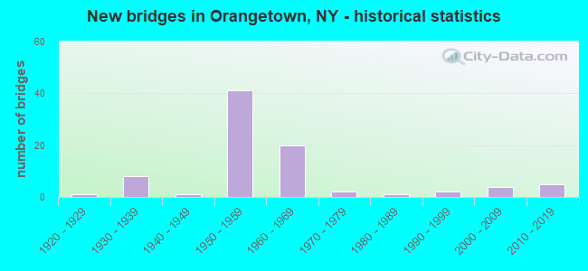
- New bridges - historical statistics
- 11920-1929
- 81930-1939
- 11940-1949
- 411950-1959
- 201960-1969
- 21970-1979
- 11980-1989
- 21990-1999
- 42000-2009
- 52010-2019
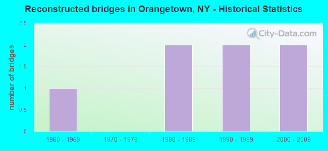
- Reconstructed bridges - Historical Statistics
- 11960-1969
- 01970-1979
- 21980-1989
- 21990-1999
- 22000-2009
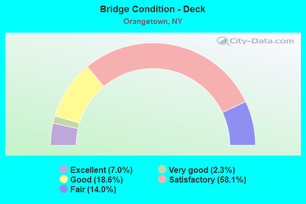
- Bridge Condition - Deck
- 7.0%Excellent
- 2.3%Very good
- 18.6%Good
- 58.1%Satisfactory
- 14.0%Fair
- Bridge Condition - Superstructure
- 6.1%Excellent
- 10.2%Very good
- 20.4%Good
- 53.1%Satisfactory
- 8.2%Fair
- 2.0%Poor
- Bridge Condition - Substructure
- 8.2%Excellent
- 4.1%Very good
- 18.4%Good
- 55.1%Satisfactory
- 14.3%Fair
- Bridge Condition - Channel
- 7.7%Excellent
- 3.8%Very good
- 7.7%Good
- 50.0%Satisfactory
- 30.8%Fair
- Bridge Condition - Culverts
- 25.0%Good
- 75.0%Satisfactory
Find on map >> Show street view
Structure Number: 222413, Location: 1.0 MI SW OF SPARKILL (Lat: 41.024325, Lng: -73.948094), Route carried "on" structure: Other road , Year Built: 1931, Status: Open, Structure Length: 0.98m (3.22ft), Average Daily Traffic: 4,454 (year 2018), Truck Traffic: 2%, Average Future Daily Traffic: 5,510 (year 2040), Features Intersected: SPARKILL CREEK, Facility Carried by Structure: KINGS HIGHWAY
Minimum Vertical Clearance: 30+ m (98+ ft), Kilometerpoint: 0.257, Lanes on structure: 2, Owner: Town or Township Highway Agency, Approaching Roadway Width: 9.2m (30.2ft), Skew: 1 degrees, Material/Design: Concrete, Design/Construction: Stringer/Multi-beam, Number Of Spans In Main Unit: 1, Length of Maximum Span: 7.9m (25.9ft), Curb or Sidewalk Widths: Left: 1.3m (4.3ft), Right: 1.3m (4.3ft), Curb-To-Curb Width: 9.2m (30.2ft), Out-to-Out Width: 12.9m (42.3ft)
Condition: Deck: Fair, Superstructure: Fair, Substructure: Satisfactory, Channel: Fair, Operating Rating: 68.6 metric tons, Method Used To Determine Operating Rating: Field evaluation and documented engineering judgment, Inventory Rating: 18.3 metric tons, Method Used To Determine Inventory Rating: Field evaluation and documented engineering judgment, Structural Evaluation: Somewhat better than minimum adequacy, Deck Geometry: Meets minimum limits, Waterway Adequacy: Equal to present desirable criteria, Approach Roadway Alignment: Somewhat better than minimum adequacy, Length Of Structure Improvement: 0.97m (3.18ft), Designated Inspection Frequency: Every 24 months, Inspection Date: March 2021, Bridge Improvement Cost: $543,000, Roadway Improvement Cost: $318,000, Total Project Cost: $860,000 ( Estimate for 2021), Deck Structure Type: Concrete Cast-file-Place, Wearing Surface/Protective System: Wearing Surface: Bituminous
Find on map >> Show street view
Structure Number: 227106, Location: 500' S of CR 8 (Lat: 41.020581, Lng: -73.946831), Route carried "on" structure: Other road , Year Built: 2015, Status: Open, Structure Length: 1.34m (4.40ft), Average Daily Traffic: 3,936 (year 2018), Truck Traffic: 2%, Average Future Daily Traffic: 3,954 (year 2040), Design Load: HL 93, Features Intersected: Sparkill Creek, Facility Carried by Structure: Oak Tree Road
Minimum Vertical Clearance: 30+ m (98+ ft), Kilometerpoint: 0.113, Lanes on structure: 2, Owner: Town or Township Highway Agency, Approaching Roadway Width: 7.9m (25.9ft), Material/Design: Prestressed concrete, Design/Construction: Box Beam or Girders - Multiple, Number Of Spans In Main Unit: 1, Length of Maximum Span: 12.8m (42.0ft), Curb or Sidewalk Widths: Left: 1.6m (5.2ft), Right: 0.0m, Curb-To-Curb Width: 7.9m (25.9ft), Out-to-Out Width: 10.9m (35.8ft)
Condition: Deck: Good, Superstructure: Very good, Substructure: Excellent, Channel: Satisfactory, Operating Rating: 68.0 metric tons, Method Used To Determine Operating Rating: Load and Resistance Factor Rating (LRFR) rating reported by rating factor(RF) method using HL-93 loadings, Inventory Rating: 52.5 metric tons, Method Used To Determine Inventory Rating: Load and Resistance Factor Rating (LRFR) rating reported by rating factor(RF) method using HL-93 loadings, Structural Evaluation: Equal to present desirable criteria, Deck Geometry: High priority of corrective action, Waterway Adequacy: Equal to present desirable criteria, Approach Roadway Alignment: Equal to present desirable criteria, Length Of Structure Improvement: 1.34m (4.40ft), Designated Inspection Frequency: Every 24 months, Inspection Date: June 2020, Bridge Improvement Cost: $545,000, Roadway Improvement Cost: $319,000, Total Project Cost: $864,000 ( Estimate for 2021), Deck Structure Type: Concrete Cast-file-Place, Wearing Surface/Protective System: Wearing Surface: Integral Concrete, Deck Protection: Epoxy Coated Reinforcing
Find on map >> Show street view
Structure Number: 334595, Location: 3.6 MI NW OF SPARKILL (Lat: 41.060544, Lng: -73.985789), Route carried "on" structure: Other road , Year Built: 1925, Year Reconstructed: 1994, Status: Open, Structure Length: 1.52m (4.99ft), Average Daily Traffic: 1,667 (year 2018), Truck Traffic: 3%, Average Future Daily Traffic: 2,062 (year 2040), Design Load: HS 25 or greater, Features Intersected: HACKENSACK RIVER, Facility Carried by Structure: BLAUVELT ROAD
Minimum Vertical Clearance: 30+ m (98+ ft), Kilometerpoint: 0.257, Lanes on structure: 2, Owner: County Highway Agency, Approaching Roadway Width: 7.9m (25.9ft), Material/Design: Steel, Design/Construction: Stringer/Multi-beam, Number Of Spans In Main Unit: 1, Length of Maximum Span: 14.3m (46.9ft), Curb-To-Curb Width: 7.9m (25.9ft), Out-to-Out Width: 8.9m (29.2ft)
Condition: Deck: Very good, Superstructure: Excellent, Substructure: Good, Channel: Very good, Inventory Rating: 63.5 metric tons, Method Used To Determine Inventory Rating: Allowable Stress (AS), Structural Evaluation: Better than present minimum criteria, Deck Geometry: Meets minimum limits, Waterway Adequacy: Equal to present minimum criteria, Approach Roadway Alignment: Better than present minimum criteria, Length Of Structure Improvement: 1.52m (4.99ft), Designated Inspection Frequency: Every 24 months, Inspection Date: August 2020, Bridge Improvement Cost: $729,000, Roadway Improvement Cost: $427,000, Total Project Cost: $1,156,000 ( Estimate for 2021), Deck Structure Type: Concrete Cast-file-Place, Wearing Surface/Protective System: Wearing Surface: Integral Concrete, Deck Protection: Epoxy Coated Reinforcing
Find on map >> Show street view
Structure Number: 334596, Location: 3.2 MI SW OF NYACK (Lat: 41.070242, Lng: -73.975531), Route carried "on" structure: Other road , Year Built: 1983, Status: Open, Structure Length: 2.56m (8.40ft), Average Daily Traffic: 2,186 (year 2018), Truck Traffic: 2%, Average Future Daily Traffic: 2,704 (year 2040), Design Load: HS 20, Features Intersected: HACKENSACK RIVER, Facility Carried by Structure: FIFTH AVENUE
Minimum Vertical Clearance: 30+ m (98+ ft), Kilometerpoint: 0.257, Lanes on structure: 2, Owner: County Highway Agency, Approaching Roadway Width: 9.8m (32.2ft), Material/Design: Prestressed concrete, Design/Construction: Box Beam or Girders - Multiple, Number Of Spans In Main Unit: 1, Length of Maximum Span: 24.9m (81.7ft), Curb-To-Curb Width: 9.8m (32.2ft), Out-to-Out Width: 10.5m (34.4ft)
Condition: Deck: Fair, Superstructure: Good, Substructure: Good, Channel: Good, Operating Rating: 70.6 metric tons, Method Used To Determine Operating Rating: Load and Resistance Factor Rating (LRFR) rating reported by rating factor(RF) method using HL-93 loadings, Inventory Rating: 42.1 metric tons, Method Used To Determine Inventory Rating: Load and Resistance Factor Rating (LRFR) rating reported by rating factor(RF) method using HL-93 loadings, Structural Evaluation: Better than present minimum criteria, Deck Geometry: Meets minimum limits, Waterway Adequacy: Somewhat better than minimum adequacy, Approach Roadway Alignment: Equal to present desirable criteria, Length Of Structure Improvement: 2.56m (8.40ft), Designated Inspection Frequency: Every 24 months, Inspection Date: June 2021, Bridge Improvement Cost: $920,000, Roadway Improvement Cost: $539,000, Total Project Cost: $1,459,000 ( Estimate for 2021), Wearing Surface/Protective System: Wearing Surface: Monolithic Concrete
Find on map >> Show street view
Structure Number: 334597, Location: 3.8 MI NW OF SPARKILL (Lat: 41.058781, Lng: -73.992458), Route carried "on" structure: County highway , Year Built: 2006, Status: Open, Structure Length: 0.91m (2.99ft), Average Daily Traffic: 3,745 (year 2018), Truck Traffic: 4%, Average Future Daily Traffic: 4,549 (year 2040), Design Load: HS 25 or greater, Features Intersected: NAURAUSHAUN BROOK, Facility Carried by Structure: SICKLETOWN ROAD
Minimum Vertical Clearance: 30+ m (98+ ft), Kilometerpoint: 0.434, Lanes on structure: 2, Owner: County Highway Agency, Approaching Roadway Width: 9.1m (29.9ft), Material/Design: Concrete, Design/Construction: Frame, Number Of Spans In Main Unit: 1, Length of Maximum Span: 8.5m (27.9ft), Curb or Sidewalk Widths: Left: 0.0m, Right: 1.5m (4.9ft), Curb-To-Curb Width: 9.0m (29.5ft), Out-to-Out Width: 11.8m (38.7ft)
Condition: Deck: Good, Superstructure: Very good, Substructure: Very good, Channel: Fair, Operating Rating: 85.3 metric tons, Method Used To Determine Operating Rating: Load Factor (LF), Inventory Rating: 50.8 metric tons, Method Used To Determine Inventory Rating: Load Factor (LF), Structural Evaluation: Equal to present desirable criteria, Deck Geometry: Meets minimum limits, Waterway Adequacy: Meets minimum limits, Approach Roadway Alignment: Somewhat better than minimum adequacy, Length Of Structure Improvement: 0.91m (2.99ft), Designated Inspection Frequency: Every 24 months, Inspection Date: March 2021, Bridge Improvement Cost: $710,000, Roadway Improvement Cost: $416,000, Total Project Cost: $1,126,000 ( Estimate for 2021)
Find on map >> Show street view
Structure Number: 334598, Location: 5.2 MI NW OF SPARKILL (Lat: 41.056375, Lng: -74.023792), Route carried "on" structure: Other road , Year Built: 1930, Status: Open, Structure Length: 0.91m (2.99ft), Average Daily Traffic: 4,241 (year 2018), Truck Traffic: 2%, Average Future Daily Traffic: 5,937 (year 2038), Features Intersected: MUDDY CREEK, Facility Carried by Structure: JEFFERSON AVENUE
Minimum Vertical Clearance: 30+ m (98+ ft), Kilometerpoint: 0.241, Lanes on structure: 2, Owner: County Highway Agency, Approaching Roadway Width: 8.8m (28.9ft), Material/Design: Aluminum, Iron, Design/Construction: Culvert, Number Of Spans In Main Unit: 2, Length of Maximum Span: 3.6m (11.8ft), Curb-To-Curb Width: 9.4m (30.8ft), Out-to-Out Width: 10.3m (33.8ft)
Condition: Channel: Satisfactory, Culverts: Satisfactory, Operating Rating: 72.5 metric tons, Method Used To Determine Operating Rating: Field evaluation and documented engineering judgment, Inventory Rating: 32.7 metric tons, Method Used To Determine Inventory Rating: Field evaluation and documented engineering judgment, Structural Evaluation: Equal to present minimum criteria, Deck Geometry: Meets minimum limits, Waterway Adequacy: Meets minimum limits, Approach Roadway Alignment: Somewhat better than minimum adequacy, Length Of Structure Improvement: 0.91m (2.99ft), Designated Inspection Frequency: Every 24 months, Inspection Date: Febuary 2021, Bridge Improvement Cost: $265,000, Roadway Improvement Cost: $155,000, Total Project Cost: $421,000 ( Estimate for 2021)
Find on map >> Show street view
Structure Number: 334599, Location: 3.2 MI NW OF SPARKILL (Lat: 41.044164, Lng: -73.988053), Route carried "on" structure: County highway , Year Built: 1954, Year Reconstructed: 1967, Status: Open, Structure Length: 3.66m (12.01ft), Average Daily Traffic: 14,052 (year 2018), Truck Traffic: 3%, Average Future Daily Traffic: 17,070 (year 2040), Design Load: HS 20, Features Intersected: TAPPAN LAKE, Facility Carried by Structure: VETERANS MEMORIAL
Minimum Vertical Clearance: 30+ m (98+ ft), Kilometerpoint: 3.250, Lanes on structure: 4, Owner: County Highway Agency, Approaching Roadway Width: 16.5m (54.1ft), Material/Design: Steel, Design/Construction: Stringer/Multi-beam, Number Of Spans In Main Unit: 1, Number Of Approach Spans: 2, Length of Maximum Span: 25.6m (84.0ft), Curb or Sidewalk Widths: Left: 0.9m (3.0ft), Right: 1.7m (5.6ft), Curb-To-Curb Width: 14.6m (47.9ft), Out-to-Out Width: 17.5m (57.4ft)
Condition: Deck: Satisfactory, Superstructure: Fair, Substructure: Fair, Channel: Satisfactory, Operating Rating: 62.6 metric tons, Method Used To Determine Operating Rating: Load Factor (LF), Inventory Rating: 37.2 metric tons, Method Used To Determine Inventory Rating: Load Factor (LF), Structural Evaluation: Somewhat better than minimum adequacy, Deck Geometry: High priority of replacement, Waterway Adequacy: Somewhat better than minimum adequacy, Approach Roadway Alignment: Better than present minimum criteria, Length Of Structure Improvement: 3.65m (11.98ft), Designated Inspection Frequency: Every 24 months, Inspection Date: October 2021, Bridge Improvement Cost: $2,567,000, Roadway Improvement Cost: $1,503,000, Total Project Cost: $4,071,000 ( Estimate for 2021), Wearing Surface/Protective System: Wearing Surface: Bituminous
Find on map >> Show street view
Structure Number: 3346, Location: 3.2 MI NW OF SPARKILL (Lat: 41.054517, Lng: -73.981983), Route carried "on" structure: County highway , Year Built: 1967, Status: Open, Structure Length: 1.71m (5.61ft), Average Daily Traffic: 2,495 (year 2016), Truck Traffic: 3%, Average Future Daily Traffic: 3,030 (year 2040), Design Load: HS 20, Features Intersected: TAPPAN LAKE, Facility Carried by Structure: CONVENT ROAD
Minimum Vertical Clearance: 30+ m (98+ ft), Kilometerpoint: 2.285, Lanes on structure: 2, Owner: County Highway Agency, Approaching Roadway Width: 7.3m (24.0ft), Material/Design: Steel, Design/Construction: Stringer/Multi-beam, Number Of Spans In Main Unit: 1, Length of Maximum Span: 15.8m (51.8ft), Curb or Sidewalk Widths: Left: 1.5m (4.9ft), Right: 1.5m (4.9ft), Curb-To-Curb Width: 12.2m (40.0ft), Out-to-Out Width: 15.8m (51.8ft)
Condition: Deck: Good, Superstructure: Good, Substructure: Satisfactory, Channel: Good, Operating Rating: 63.8 metric tons, Method Used To Determine Operating Rating: Load and Resistance Factor Rating (LRFR) rating reported by rating factor(RF) method using HL-93 loadings, Inventory Rating: 48.9 metric tons, Method Used To Determine Inventory Rating: Load and Resistance Factor Rating (LRFR) rating reported by rating factor(RF) method using HL-93 loadings, Structural Evaluation: Equal to present minimum criteria, Deck Geometry: Equal to present minimum criteria, Waterway Adequacy: Somewhat better than minimum adequacy, Approach Roadway Alignment: Better than present minimum criteria, Length Of Structure Improvement: 1.70m (5.58ft), Designated Inspection Frequency: Every 24 months, Underwater Inspection Frequency: Every 60 months, Inspection Date: November 2021, Underwater Inspection Date: August 2019, Bridge Improvement Cost: $2,255,000, Roadway Improvement Cost: $1,321,000, Total Project Cost: $3,576,000 ( Estimate for 2021), Deck Structure Type: Concrete Cast-file-Place, Wearing Surface/Protective System: Wearing Surface: Bituminous, Membrane: Epoxy
Find on map >> Show street view
Structure Number: 334602, Location: 5.9 MI NW OF SPARKILL (Lat: 41.059550, Lng: -74.035933), Route carried "on" structure: Other road , Year Built: 1930, Status: Open, Structure Length: 1.04m (3.41ft), Average Daily Traffic: 8,819 (year 2015), Truck Traffic: 3%, Average Future Daily Traffic: 10,911 (year 2040), Features Intersected: PASCACK BROOK, Facility Carried by Structure: WASHINGTON AVENUE
Minimum Vertical Clearance: 30+ m (98+ ft), Kilometerpoint: 0.998, Lanes on structure: 2, Owner: County Highway Agency, Approaching Roadway Width: 8.8m (28.9ft), Skew: 3 degrees, Material/Design: Steel, Design/Construction: Stringer/Multi-beam, Number Of Spans In Main Unit: 1, Length of Maximum Span: 10.0m (32.8ft), Curb-To-Curb Width: 8.9m (29.2ft), Out-to-Out Width: 9.8m (32.2ft)
Condition: Deck: Satisfactory, Superstructure: Satisfactory, Substructure: Satisfactory, Channel: Fair, Operating Rating: 21.7 metric tons, Method Used To Determine Operating Rating: Load and Resistance Factor Rating (LRFR) rating reported by rating factor(RF) method using HL-93 loadings, Inventory Rating: 16.8 metric tons, Method Used To Determine Inventory Rating: Load and Resistance Factor Rating (LRFR) rating reported by rating factor(RF) method using HL-93 loadings, Structural Evaluation: Meets minimum limits, Deck Geometry: High priority of replacement, Waterway Adequacy: Meets minimum limits, Approach Roadway Alignment: Somewhat better than minimum adequacy, Length Of Structure Improvement: 1.03m (3.38ft), Designated Inspection Frequency: Every 24 months, Underwater Inspection Frequency: Every 60 months, Inspection Date: March 2021, Underwater Inspection Date: March 2021, Bridge Improvement Cost: $873,000, Roadway Improvement Cost: $512,000, Total Project Cost: $1,385,000 ( Estimate for 2021), Deck Structure Type: Concrete Cast-file-Place, Wearing Surface/Protective System: Wearing Surface: Bituminous
Find on map >> Show street view
Structure Number: 334603, Location: 1.8 MI NW OF SPARKILL (Lat: 41.051186, Lng: -73.949386), Route carried "on" structure: Other road , Year Built: 1992, Status: Open, Structure Length: 4.54m (14.90ft), Average Daily Traffic: 4,549 (year 2017), Truck Traffic: 3%, Average Future Daily Traffic: 6,369 (year 2037), Design Load: HS 20, Features Intersected: CSX TRANS/RIVR LN, Facility Carried by Structure: MOUNTAIN VIEW AVE
Minimum Vertical Clearance: 30+ m (98+ ft), Kilometerpoint: 0.241, Lanes on structure: 2, Owner: County Highway Agency, Approaching Roadway Width: 9.1m (29.9ft), Skew: 2 degrees, Material/Design: Prestressed concrete, Design/Construction: Box Beam or Girders - Multiple, Number Of Spans In Main Unit: 3, Length of Maximum Span: 17.9m (58.7ft), Curb or Sidewalk Widths: Left: 0.0m, Right: 1.5m (4.9ft), Curb-To-Curb Width: 9.1m (29.9ft), Out-to-Out Width: 11.3m (37.1ft)
Condition: Deck: Fair, Superstructure: Poor, Substructure: Good, Operating Rating: 62.5 metric tons, Method Used To Determine Operating Rating: Load and Resistance Factor Rating (LRFR) rating reported by rating factor(RF) method using HL-93 loadings, Inventory Rating: 33.0 metric tons, Method Used To Determine Inventory Rating: Load and Resistance Factor Rating (LRFR) rating reported by rating factor(RF) method using HL-93 loadings, Structural Evaluation: Meets minimum limits, Deck Geometry: Meets minimum limits, Underclear: Meets minimum limits, Approach Roadway Alignment: Equal to present desirable criteria, Length Of Structure Improvement: 4.54m (14.90ft), Designated Inspection Frequency: Every 24 months, Inspection Date: June 2020, Bridge Improvement Cost: $1,300,000, Roadway Improvement Cost: $761,000, Total Project Cost: $2,062,000 ( Estimate for 2021), Wearing Surface/Protective System: Wearing Surface: Monolithic Concrete
Find on map >> Show street view
Structure Number: 334604, Location: 1.5 MI NW OF SPARKILL (Lat: 41.046433, Lng: -73.949383), Route carried "on" structure: County highway , Year Built: 2016, Status: Open, Structure Length: 3.72m (12.20ft), Average Daily Traffic: 8,891 (year 2018), Truck Traffic: 8%, Average Future Daily Traffic: 10,800 (year 2040), Design Load: HL 93, Features Intersected: CSX Transportation, Facility Carried by Structure: ORANGEBURG ROAD
Minimum Vertical Clearance: 30+ m (98+ ft), Kilometerpoint: 6.661, Lanes on structure: 4, Owner: County Highway Agency, Approaching Roadway Width: 16.8m (55.1ft), Material/Design: Steel, Design/Construction: Stringer/Multi-beam, Number Of Spans In Main Unit: 1, Length of Maximum Span: 36.6m (120.1ft), Curb or Sidewalk Widths: Left: 2.5m (8.2ft), Right: 2.5m (8.2ft), Curb-To-Curb Width: 16.8m (55.1ft), Out-to-Out Width: 22.5m (73.8ft)
Condition: Deck: Excellent, Superstructure: Very good, Substructure: Excellent, Operating Rating: 69.0 metric tons, Method Used To Determine Operating Rating: Load and Resistance Factor Rating (LRFR) rating reported by rating factor(RF) method using HL-93 loadings, Inventory Rating: 39.5 metric tons, Method Used To Determine Inventory Rating: Load and Resistance Factor Rating (LRFR) rating reported by rating factor(RF) method using HL-93 loadings, Structural Evaluation: Equal to present desirable criteria, Deck Geometry: Somewhat better than minimum adequacy, Underclear: High priority of corrective action, Approach Roadway Alignment: Equal to present desirable criteria, Length Of Structure Improvement: 3.71m (12.17ft), Designated Inspection Frequency: Every 24 months, Inspection Date: June 2020, Bridge Improvement Cost: $4,613,000, Roadway Improvement Cost: $2,701,000, Total Project Cost: $7,314,000 ( Estimate for 2021), Deck Structure Type: Concrete Cast-file-Place, Wearing Surface/Protective System: Wearing Surface: Monolithic Concrete, Deck Protection: Epoxy Coated Reinforcing
Find on map >> Show street view
Structure Number: 334606, Location: 1.0 MI SW OF SPARKILL (Lat: 41.021833, Lng: -73.946744), Route carried "on" structure: County highway , Year Built: 1940, Year Reconstructed: 1994, Status: Open, Structure Length: 0.76m (2.49ft), Average Daily Traffic: 4,852 (year 2016), Truck Traffic: 2%, Average Future Daily Traffic: 5,894 (year 2040), Design Load: HS 25 or greater, Features Intersected: SPARKILL CREEK, Facility Carried by Structure: WASHINGTON STREET
Minimum Vertical Clearance: 30+ m (98+ ft), Kilometerpoint: 0.080, Lanes on structure: 2, Owner: County Highway Agency, Approaching Roadway Width: 7.9m (25.9ft), Skew: 1 degrees, Material/Design: Prestressed concrete, Design/Construction: Box Beam or Girders - Multiple, Number Of Spans In Main Unit: 1, Length of Maximum Span: 6.7m (22.0ft), Curb or Sidewalk Widths: Left: 1.8m (5.9ft), Right: 1.8m (5.9ft), Curb-To-Curb Width: 8.5m (27.9ft), Out-to-Out Width: 13.7m (44.9ft)
Condition: Deck: Good, Superstructure: Good, Substructure: Satisfactory, Channel: Satisfactory, Operating Rating: 59.9 metric tons, Method Used To Determine Operating Rating: Load Factor (LF), Inventory Rating: 43.5 metric tons, Method Used To Determine Inventory Rating: Load Factor (LF), Structural Evaluation: Equal to present minimum criteria, Deck Geometry: Meets minimum limits, Waterway Adequacy: Somewhat better than minimum adequacy, Approach Roadway Alignment: Equal to present desirable criteria, Length Of Structure Improvement: 0.76m (2.49ft), Designated Inspection Frequency: Every 24 months, Inspection Date: October 2020, Bridge Improvement Cost: $337,000, Roadway Improvement Cost: $197,000, Total Project Cost: $534,000 ( Estimate for 2021), Wearing Surface/Protective System: Wearing Surface: Bituminous, Membrane: Other
Find on map >> Show street view
Structure Number: 334607, Location: 0.6 MI S OF PIERMONT (Lat: 41.028794, Lng: -73.926075), Route carried "on" structure: Other road , Year Built: 1950, Status: Open, Structure Length: 1.28m (4.20ft), Average Daily Traffic: 1,310 (year 2017), Truck Traffic: 10%, Average Future Daily Traffic: 1,834 (year 2037), Features Intersected: SPARKILL CREEK, Facility Carried by Structure: WILLIAM STREET
Minimum Vertical Clearance: 30+ m (98+ ft), Kilometerpoint: 0.370, Lanes on structure: 2, Owner: County Highway Agency, Approaching Roadway Width: 7.3m (24.0ft), Skew: 4 degrees, Material/Design: Concrete, Design/Construction: Tee Beam, Number Of Spans In Main Unit: 1, Length of Maximum Span: 11.8m (38.7ft), Curb or Sidewalk Widths: Left: 0.7m (2.3ft), Right: 0.7m (2.3ft), Curb-To-Curb Width: 7.3m (24.0ft), Out-to-Out Width: 9.6m (31.5ft)
Condition: Deck: Satisfactory, Superstructure: Satisfactory, Substructure: Satisfactory, Channel: Satisfactory, Operating Rating: 44.5 metric tons, Method Used To Determine Operating Rating: Load Factor (LF), Inventory Rating: 26.3 metric tons, Method Used To Determine Inventory Rating: Load Factor (LF), Structural Evaluation: Equal to present minimum criteria, Deck Geometry: Meets minimum limits, Waterway Adequacy: Meets minimum limits, Approach Roadway Alignment: Meets minimum limits, Length Of Structure Improvement: 1.28m (4.20ft), Designated Inspection Frequency: Every 24 months, Inspection Date: March 2021, Bridge Improvement Cost: $620,000, Roadway Improvement Cost: $363,000, Total Project Cost: $983,000 ( Estimate for 2021), Deck Structure Type: Concrete Cast-file-Place, Wearing Surface/Protective System: Wearing Surface: Bituminous, Membrane: Other
Find on map >> Show street view
Structure Number: 334609, Location: 1.0 MI S OF SPARKILL (Lat: 41.015853, Lng: -73.937492), Route carried "on" structure: Other road , Year Built: 2014, Status: Open, Structure Length: 0.94m (3.08ft), Average Daily Traffic: 6,689 (year 2016), Truck Traffic: 4%, Average Future Daily Traffic: 8,125 (year 2040), Design Load: HS 25 or greater, Features Intersected: SPARKILL CREEK, Facility Carried by Structure: OAK TREE ROAD
Minimum Vertical Clearance: 30+ m (98+ ft), Kilometerpoint: 1.046, Lanes on structure: 2, Owner: County Highway Agency, Approaching Roadway Width: 10.7m (35.1ft), Material/Design: Concrete, Design/Construction: Frame, Number Of Spans In Main Unit: 1, Length of Maximum Span: 9.1m (29.9ft), Curb or Sidewalk Widths: Left: 4.0m (13.1ft), Right: 4.0m (13.1ft), Curb-To-Curb Width: 10.8m (35.4ft), Out-to-Out Width: 20.1m (65.9ft)
Condition: Deck: Satisfactory, Superstructure: Good, Substructure: Good, Channel: Satisfactory, Operating Rating: 92.5 metric tons, Method Used To Determine Operating Rating: Load Factor (LF), Inventory Rating: 55.3 metric tons, Method Used To Determine Inventory Rating: Load Factor (LF), Structural Evaluation: Better than present minimum criteria, Deck Geometry: Meets minimum limits, Waterway Adequacy: Superior to present desirable criteria, Approach Roadway Alignment: Equal to present desirable criteria, Length Of Structure Improvement: 0.94m (3.08ft), Designated Inspection Frequency: Every 24 months, Inspection Date: March 2021, Bridge Improvement Cost: $878,000, Roadway Improvement Cost: $514,000, Total Project Cost: $1,392,000 ( Estimate for 2021)
Find on map >> Show street view
Structure Number: 336473, Location: 1.7 MI W OF PIERMONT (Lat: 41.046761, Lng: -73.945958), Route carried "on" structure: County highway , Year Built: 1967, Status: Open, Structure Length: 1.01m (3.31ft), Average Daily Traffic: 8,891 (year 2018), Truck Traffic: 8%, Average Future Daily Traffic: 10,800 (year 2040), Features Intersected: SPARKILL CREEK, Facility Carried by Structure: ORANGEBURG ROAD
Minimum Vertical Clearance: 30+ m (98+ ft), Kilometerpoint: 6.967, Lanes on structure: 4, Owner: County Highway Agency, Approaching Roadway Width: 14.6m (47.9ft), Skew: 2 degrees, Material/Design: Concrete continuous, Design/Construction: Culvert, Number Of Spans In Main Unit: 2, Length of Maximum Span: 4.2m (13.8ft), Curb or Sidewalk Widths: Left: 0.0m, Right: 2.7m (8.9ft)
Condition: Channel: Satisfactory, Culverts: Satisfactory, Operating Rating: 76.2 metric tons, Method Used To Determine Operating Rating: Allowable Stress (AS), Inventory Rating: 45.4 metric tons, Method Used To Determine Inventory Rating: Allowable Stress (AS), Structural Evaluation: Equal to present minimum criteria, Waterway Adequacy: Meets minimum limits, Approach Roadway Alignment: Better than present minimum criteria, Length Of Structure Improvement: 1.00m (3.28ft), Designated Inspection Frequency: Every 24 months, Inspection Date: March 2021, Bridge Improvement Cost: $803,000, Roadway Improvement Cost: $470,000, Total Project Cost: $1,273,000 ( Estimate for 2021)
Find on map >> Show street view
Structure Number: 336474, Location: 4.4 MI NW OF PIERMONT (Lat: 41.061403, Lng: -73.994428), Route carried "on" structure: Other road , Year Built: 1974, Status: Open, Structure Length: 1.34m (4.40ft), Average Daily Traffic: 4,995 (year 2017), Truck Traffic: 2%, Average Future Daily Traffic: 6,180 (year 2040), Features Intersected: NAURAUSHAUN BROOK, Facility Carried by Structure: BLAUVELT ROAD
Minimum Vertical Clearance: 30+ m (98+ ft), Kilometerpoint: 1.641, Lanes on structure: 2, Owner: County Highway Agency, Approaching Roadway Width: 7.3m (24.0ft), Skew: 5 degrees, Material/Design: Concrete, Design/Construction: Culvert, Number Of Spans In Main Unit: 1, Length of Maximum Span: 12.8m (42.0ft), Curb-To-Curb Width: 14.6m (47.9ft), Out-to-Out Width: 18.3m (60.0ft)
Condition: Channel: Satisfactory, Culverts: Good, Operating Rating: 94.3 metric tons, Method Used To Determine Operating Rating: Allowable Stress (AS), Inventory Rating: 39.9 metric tons, Method Used To Determine Inventory Rating: Allowable Stress (AS), Structural Evaluation: Better than present minimum criteria, Deck Geometry: Superior to present desirable criteria, Waterway Adequacy: Superior to present desirable criteria, Approach Roadway Alignment: Meets minimum limits, Length Of Structure Improvement: 1.34m (4.40ft), Designated Inspection Frequency: Every 24 months, Inspection Date: March 2021, Bridge Improvement Cost: $691,000, Roadway Improvement Cost: $405,000, Total Project Cost: $1,095,000 ( Estimate for 2021)
Find on map >> Show street view
Structure Number: 336475, Location: 3.8 MI W OF SOUTH NYACK (Lat: 41.078783, Lng: -73.997453), Route carried "on" structure: Other road , Year Built: 1974, Status: Open, Structure Length: 0.88m (2.89ft), Average Daily Traffic: 5,222 (year 2015), Truck Traffic: 4%, Average Future Daily Traffic: 6,343 (year 2040), Features Intersected: NAURAUSHAUN BROOK, Facility Carried by Structure: TOWNLINE ROAD
Minimum Vertical Clearance: 30+ m (98+ ft), Kilometerpoint: 2.800, Lanes on structure: 2, Owner: County Highway Agency, Approaching Roadway Width: 6.7m (22.0ft), Material/Design: Concrete, Design/Construction: Culvert, Number Of Spans In Main Unit: 1, Length of Maximum Span: 8.2m (26.9ft), Curb or Sidewalk Widths: Left: 1.4m (4.6ft), Right: 1.4m (4.6ft), Curb-To-Curb Width: 12.1m (39.7ft), Out-to-Out Width: 15.8m (51.8ft)
Condition: Channel: Satisfactory, Culverts: Satisfactory, Operating Rating: 52.6 metric tons, Method Used To Determine Operating Rating: Allowable Stress (AS), Inventory Rating: 35.4 metric tons, Method Used To Determine Inventory Rating: Allowable Stress (AS), Structural Evaluation: Equal to present minimum criteria, Deck Geometry: Somewhat better than minimum adequacy, Waterway Adequacy: Meets minimum limits, Approach Roadway Alignment: Somewhat better than minimum adequacy, Length Of Structure Improvement: 0.88m (2.89ft), Designated Inspection Frequency: Every 24 months, Inspection Date: July 2021, Bridge Improvement Cost: $724,000, Roadway Improvement Cost: $424,000, Total Project Cost: $1,148,000 ( Estimate for 2021)
Find on map >> Show street view
Structure Number: 336928, Location: 3 MILES NW OF SPARKILL (Lat: 41.069717, Lng: -73.951247), Route carried "on" structure: Other road , Year Built: 1999, Status: Open, Structure Length: 5.18m (16.99ft), Average Daily Traffic: 502 (year 2017), Truck Traffic: 4%, Average Future Daily Traffic: 621 (year 2040), Design Load: HS 25 or greater, Features Intersected: CSX TRANS/ RVR LN, Facility Carried by Structure: LEBER ROAD
Minimum Vertical Clearance: 30+ m (98+ ft), Kilometerpoint: 0.064, Lanes on structure: 1, Owner: County Highway Agency, Approaching Roadway Width: 4.9m (16.1ft), Skew: 5 degrees, Material/Design: Steel continuous, Design/Construction: Stringer/Multi-beam, Number Of Spans In Main Unit: 3, Length of Maximum Span: 20.1m (65.9ft), Curb or Sidewalk Widths: Left: 0.0m, Right: 1.5m (4.9ft), Curb-To-Curb Width: 4.8m (15.7ft), Out-to-Out Width: 7.6m (24.9ft)
Condition: Deck: Satisfactory, Superstructure: Very good, Substructure: Very good, Operating Rating: 98.0 metric tons, Method Used To Determine Operating Rating: Load Factor (LF), Inventory Rating: 58.1 metric tons, Method Used To Determine Inventory Rating: Load Factor (LF), Structural Evaluation: Equal to present desirable criteria, Deck Geometry: High priority of corrective action, Underclear: Meets minimum limits, Approach Roadway Alignment: Equal to present desirable criteria, Length Of Structure Improvement: 5.18m (16.99ft), Designated Inspection Frequency: Every 24 months, Inspection Date: July 2021, Bridge Improvement Cost: $1,986,000, Roadway Improvement Cost: $1,163,000, Total Project Cost: $3,149,000 ( Estimate for 2021), Deck Structure Type: Concrete Cast-file-Place, Wearing Surface/Protective System: Wearing Surface: Integral Concrete, Deck Protection: Epoxy Coated Reinforcing
Find on map >> Show street view
Structure Number: 5516341, Location: I87N-I287W NB / Hudson Rv (Lat: 41.074742, Lng: -73.919600), Route carried "on" structure: Interstate 87, Year Built: 2017, Status: Open, Structure Length: 482.74m (1583.79ft), Average Daily Traffic: 62,394 (year 2014), Truck Traffic: 15%, Average Future Daily Traffic: 105,658 (year 2040), Design Load: HL 93, Features Intersected: Hudson River, MNRR HU LI
Minimum Vertical Clearance: 5.41m (17.75ft), Kilometerpoint: 0.000, Lanes on structure: 5, Lanes under structure: 2, Toll: On toll road, Owner: State Toll Authority, Approaching Roadway Width: 23.8m (78.1ft), Navigation Control: Yes ( Vertical Clearance: 999.9m (3,280.5ft), Horizontal Clearance: 347.5m (1,140.1ft)), Material/Design: Steel continuous, Design/Construction: Stayed Girder, Number Of Spans In Main Unit: 3, Number Of Approach Spans: 41, Length of Maximum Span: 365.8m (1,200.1ft), Curb or Sidewalk Widths: Left: 3.7m (12.1ft), Right: 0.0m, Curb-To-Curb Width: 23.8m (78.1ft), Out-to-Out Width: 29.3m (96.1ft)
Condition: Deck: Excellent, Superstructure: Excellent, Substructure: Excellent, Channel: Excellent, Operating Rating: 97.8 metric tons, Method Used To Determine Operating Rating: Field evaluation and documented engineering judgment, Inventory Rating: 40.8 metric tons, Method Used To Determine Inventory Rating: Field evaluation and documented engineering judgment, Structural Evaluation: Superior to present desirable criteria, Deck Geometry: Equal to present minimum criteria, Underclear: Superior to present desirable criteria, Waterway Adequacy: Superior to present desirable criteria, Approach Roadway Alignment: Equal to present desirable criteria, Length Of Structure Improvement: 482.74m (1583.79ft), Designated Inspection Frequency: Every 24 months, Critical Feature Inspection Frequency: Every 24 months, Inspection Date: August 2020, Critical Feature Inspection Date: August 2020, Bridge Improvement Cost: $500,000,000, Roadway Improvement Cost: $292,800,000, Total Project Cost: $792,800,000 ( Estimate for 2021), Deck Structure Type: Concrete Precast Panels, Wearing Surface/Protective System: Wearing Surface: Bituminous, Membrane: Epoxy
Find on map >> Show street view
Structure Number: 5516342, Location: I87SB-I287EB / Hudson Rvr (Lat: 41.074781, Lng: -73.919150), Route carried "on" structure: Interstate 87, Year Built: 2018, Status: Open, Structure Length: 484.45m (1589.40ft), Average Daily Traffic: 78,144 (year 2014), Truck Traffic: 14%, Average Future Daily Traffic: 134,251 (year 2039), Design Load: HL 93, Features Intersected: Fisher Drive, Hudson Riv
Minimum Vertical Clearance: 5.38m (17.65ft), Kilometerpoint: 0.000, Lanes on structure: 4, Lanes under structure: 4, Toll: On toll road, Owner: State Toll Authority, Approaching Roadway Width: 25.4m (83.3ft), Navigation Control: Yes ( Vertical Clearance: 999.9m (3,280.5ft), Horizontal Clearance: 347.5m (1,140.1ft)), Material/Design: Steel continuous, Design/Construction: Stayed Girder, Number Of Spans In Main Unit: 3, Number Of Approach Spans: 41, Length of Maximum Span: 365.8m (1,200.1ft), Curb-To-Curb Width: 25.4m (83.3ft), Out-to-Out Width: 26.5m (86.9ft)
Condition: Deck: Excellent, Superstructure: Excellent, Substructure: Excellent, Channel: Excellent, Inventory Rating: 40.8 metric tons, Method Used To Determine Inventory Rating: Field evaluation and documented engineering judgment, Structural Evaluation: Superior to present desirable criteria, Deck Geometry: Superior to present desirable criteria, Underclear: Meets minimum limits, Waterway Adequacy: Superior to present desirable criteria, Approach Roadway Alignment: Equal to present desirable criteria, Length Of Structure Improvement: 484.44m (1589.37ft), Designated Inspection Frequency: Every 24 months, Critical Feature Inspection Frequency: Every 24 months, Inspection Date: June 2021, Critical Feature Inspection Date: June 2021, Bridge Improvement Cost: $500,000,000, Roadway Improvement Cost: $292,800,000, Total Project Cost: $792,800,000 ( Estimate for 2021), Deck Structure Type: Concrete Precast Panels, Wearing Surface/Protective System: Wearing Surface: Bituminous, Membrane: Epoxy
Find on map >> Show street view
Structure Number: 104534, Location: 1 MI S JCT SH 303 & PIP (Lat: 41.021556, Lng: -73.942469), Route carried "under" structure: County highway , Year Built: 1932, Structure Length: 0. m, Average Daily Traffic: 7,982 (year 2018), Truck Traffic: 3%, Features Intersected: WASHINGTN ST-CR 8, Facility Carried by Structure: RTE 303
Minimum Vertical Clearance: 4.19m (13.75ft), Kilometerpoint: 0.660, Lanes on structure: 3, Lanes under structure: 2, Material/Design: Steel, Design/Construction: Stringer/Multi-beam, Length of Maximum Span: 15.8m (51.8ft)
Find on map >> Show street view
Structure Number: 104536, Location: JCT RTE 303+PIP (Lat: 41.035919, Lng: -73.946003), Route carried "under" structure: Other road 987C, Year Built: 1958, Structure Length: 0. m, Average Daily Traffic: 35,500 (year 1979), Features Intersected: 987C 987C85011025 WB, RT, Facility Carried by Structure: RTE 303
Minimum Vertical Clearance: 5.05m (16.57ft), Kilometerpoint: 4.183, Lanes on structure: 4, Lanes under structure: 3, Material/Design: Concrete continuous, Design/Construction: Frame, Length of Maximum Span: 20.7m (67.9ft)
Find on map >> Show street view
Structure Number: 104618, Location: JCT RTS 340+PIP (Lat: 41.017750, Lng: -73.928844), Route carried "under" structure: Other road , Year Built: 1954, Structure Length: 0. m, Average Daily Traffic: 19,250 (year 1979), Features Intersected: 987C 987C85011010, Facility Carried by Structure: RTE 340
Minimum Vertical Clearance: 4.85m (15.91ft), Kilometerpoint: 1.609, Lanes on structure: 2, Lanes under structure: 2, Material/Design: Concrete, Design/Construction: Frame, Length of Maximum Span: 20.7m (67.9ft)
Find on map >> Show street view
Structure Number: 1068529, Location: 0.8 MI S JCT PIP+RTE 340 (Lat: 41.007456, Lng: -73.921481), Route carried "under" structure: County highway , Year Built: 1954, Structure Length: 0. m, Average Daily Traffic: 1,136 (year 2018), Truck Traffic: 1%, Features Intersected: CR 33-CLOSTER RD, Facility Carried by Structure: RTE 987C
Minimum Vertical Clearance: 4.55m (14.93ft), Kilometerpoint: 0.000, Lanes on structure: 4, Lanes under structure: 2, Material/Design: Concrete, Design/Construction: Frame, Length of Maximum Span: 14.0m (45.9ft)
Find on map >> Show street view
Structure Number: 106853, Location: .5 MI S JCT PIP & SH 340 (Lat: 41.012122, Lng: -73.923747), Route carried "under" structure: Other road 987C, Year Built: 1954, Structure Length: 0. m, Average Daily Traffic: 36,100 (year 1979), Features Intersected: 987C 987C85011005 SB, RT, Facility Carried by Structure: OAK TREE ROAD
Minimum Vertical Clearance: 5.13m (16.83ft), Kilometerpoint: 18.343, Lanes on structure: 2, Lanes under structure: 4, Material/Design: Concrete continuous, Design/Construction: Frame, Length of Maximum Span: 23.5m (77.1ft)
Find on map >> Show street view
Structure Number: 106856, Location: 0.5 MI N JCT PIP+RTE 340 (Lat: 41.023256, Lng: -73.935392), Route carried "under" structure: Other road 987C, Year Built: 1954, Structure Length: 0. m, Average Daily Traffic: 36,100 (year 1979), Features Intersected: 987CX NB, RTE 987C, Facility Carried by Structure: WASHINGTON STREET
Minimum Vertical Clearance: 5.46m (17.91ft), Kilometerpoint: 0.000, Lanes on structure: 2, Lanes under structure: 2, Material/Design: Concrete, Design/Construction: Arch - Deck, Length of Maximum Span: 16.1m (52.8ft)
Find on map >> Show street view
Structure Number: 106857, Location: 1.1 MI N JCT PIP+RTE 340 (Lat: 41.030567, Lng: -73.940392), Route carried "under" structure: Other road 987C, Year Built: 1954, Structure Length: 0. m, Average Daily Traffic: 36,100 (year 1979), Features Intersected: RTE 987C, Facility Carried by Structure: KINGS HIGHWAY
Minimum Vertical Clearance: 4.64m (15.22ft), Kilometerpoint: 3.379, Lanes on structure: 2, Lanes under structure: 2, Material/Design: Concrete, Design/Construction: Frame, Length of Maximum Span: 19.5m (64.0ft)
Find on map >> Show street view
Structure Number: 106858, Location: 1.1 MI N JCT PIP+RTE 340 (Lat: 41.030472, Lng: -73.939706), Route carried "under" structure: Other road 987C, Year Built: 1954, Structure Length: 0. m, Average Daily Traffic: 19,600 (year 1979), Features Intersected: RTE 987C, Facility Carried by Structure: KINGS HIGHWAY
Minimum Vertical Clearance: 4.95m (16.24ft), Kilometerpoint: 3.379, Lanes on structure: 2, Lanes under structure: 2, Material/Design: Concrete, Design/Construction: Frame, Length of Maximum Span: 19.5m (64.0ft)
Find on map >> Show street view
Structure Number: 1068619, Location: .3 MI N JCT PIP & SH 303 (Lat: 41.038522, Lng: -73.950792), Route carried "under" structure: Other road , Year Built: 1956, Structure Length: 0. m, Average Daily Traffic: 2,000 (year 1982), Features Intersected: WESTERN HIGHWAY, Facility Carried by Structure: RTE 987C
Minimum Vertical Clearance: 4.41m (14.47ft), Kilometerpoint: 0.000, Lanes on structure: 6, Lanes under structure: 2, Material/Design: Concrete, Design/Construction: Frame, Length of Maximum Span: 14.9m (48.9ft)
Find on map >> Show street view
Structure Number: 1068629, Location: 1.0 MI N JCT PIP+RTE 303 (Lat: 41.045469, Lng: -73.958539), Route carried "under" structure: Other road 987C, Year Built: 1956, Structure Length: 0. m, Average Daily Traffic: 20,000 (year 1979), Features Intersected: RTE 987C, Facility Carried by Structure: ORANGEBURG ROAD
Minimum Vertical Clearance: 5.31m (17.42ft), Kilometerpoint: 5.648, Lanes on structure: 6, Lanes under structure: 3, Material/Design: Concrete, Design/Construction: Arch - Deck, Length of Maximum Span: 22.8m (74.8ft)
Find on map >> Show street view
Structure Number: 1068639, Location: 1.7 MI N JCT PIP+RTE 303 (Lat: 41.054669, Lng: -73.964764), Route carried "under" structure: Other road , Year Built: 1956, Structure Length: 0. m, Average Daily Traffic: 2,495 (year 2016), Truck Traffic: 3%, Features Intersected: CONVENT ROAD COUNTY ROAD, Facility Carried by Structure: RTE 987C
Minimum Vertical Clearance: 4.55m (14.93ft), Kilometerpoint: 0.000, Lanes on structure: 4, Lanes under structure: 2, Material/Design: Concrete, Design/Construction: Frame, Length of Maximum Span: 16.7m (54.8ft)
Find on map >> Show street view
Structure Number: 106864, Location: 2.1 MI N JCT PIP & SH 303 (Lat: 41.058858, Lng: -73.970758), Route carried "under" structure: Other road 987C, Year Built: 1956, Structure Length: 0. m, Average Daily Traffic: 19,440 (year 1979), Features Intersected: RTE 987C, Facility Carried by Structure: VAN WYCK ROAD
Minimum Vertical Clearance: 4.41m (14.47ft), Kilometerpoint: 7.562, Lanes on structure: 2, Lanes under structure: 2, Material/Design: Concrete, Design/Construction: Frame, Length of Maximum Span: 20.1m (65.9ft)
Find on map >> Show street view
Structure Number: 106866, Location: 3.1 MI N JCT PIP & SH 303 (Lat: 41.069586, Lng: -73.980336), Route carried "under" structure: Other road 987C, Year Built: 1956, Structure Length: 0. m, Average Daily Traffic: 38,730 (year 1979), Features Intersected: 987C 987C85011056 NB,, Facility Carried by Structure: SICKLETOWN ROAD
Minimum Vertical Clearance: 4.93m (16.17ft), Kilometerpoint: 9.010, Lanes on structure: 2, Lanes under structure: 2, Material/Design: Concrete continuous, Design/Construction: Frame, Length of Maximum Span: 19.5m (64.0ft)
Find on map >> Show street view
Structure Number: 1068679, Location: 3.2 MI N JCT PIP & SH 303 (Lat: 41.078683, Lng: -73.984956), Route carried "under" structure: Other road , Year Built: 1956, Structure Length: 0. m, Average Daily Traffic: 5,222 (year 2015), Truck Traffic: 4%, Features Intersected: TOWN LINE ROAD, Facility Carried by Structure: RTE 987C
Minimum Vertical Clearance: 4.31m (14.14ft), Kilometerpoint: 1.239, Lanes on structure: 6, Lanes under structure: 2, Material/Design: Concrete, Design/Construction: Frame, Length of Maximum Span: 13.7m (44.9ft)
Find on map >> Show street view
Structure Number: 106897, Location: IN ORANGEBURG (Lat: 41.059250, Lng: -73.970733), Route carried "under" structure: Other road 987C, Year Built: 1956, Structure Length: 0. m, Average Daily Traffic: 19,290 (year 1979), Features Intersected: RTE 987C, Facility Carried by Structure: VAN WYCK ROAD
Minimum Vertical Clearance: 4.49m (14.73ft), Kilometerpoint: 7.562, Lanes on structure: 2, Lanes under structure: 2, Material/Design: Concrete, Design/Construction: Frame, Length of Maximum Span: 20.1m (65.9ft)
Find on map >> Show street view
Structure Number: 1068989, Location: 1.0 MI N JCT PIP+RTE 303 (Lat: 41.045614, Lng: -73.958242), Route carried "under" structure: Other road 987C, Year Built: 1956, Structure Length: 0. m, Average Daily Traffic: 14,799 (year 1979), Features Intersected: RTE 987C, Facility Carried by Structure: ORANGEBURG ROAD
Minimum Vertical Clearance: 5.51m (18.08ft), Kilometerpoint: 5.648, Lanes on structure: 6, Lanes under structure: 3, Material/Design: Concrete, Design/Construction: Arch - Deck, Length of Maximum Span: 22.8m (74.8ft)
Find on map >> Show street view
Structure Number: 106899, Location: JCT PIP+RTE 340 (Lat: 41.018147, Lng: -73.928808), Route carried "under" structure: Other road 987C, Year Built: 1954, Structure Length: 0. m, Average Daily Traffic: 100 (year 2021), Features Intersected: RTE 987C, Facility Carried by Structure: RTE 340
Minimum Vertical Clearance: 4.94m (16.21ft), Kilometerpoint: 0.000, Lanes on structure: 2, Lanes under structure: 2, Material/Design: Concrete, Design/Construction: Frame, Length of Maximum Span: 20.7m (67.9ft)
Find on map >> Show street view
Structure Number: 1091171, Location: 2.4 MI S JCT RTS 304+59 (Lat: 41.068164, Lng: -74.025825), Route carried "under" structure: City street , Year Built: 1968, Structure Length: 0. m, Average Daily Traffic: 2,058 (year 2018), Truck Traffic: 2%, Features Intersected: W CROOKED HILL RD, Facility Carried by Structure: RTE 304
Minimum Vertical Clearance: 8.05m (26.41ft), Kilometerpoint: 0.000, Lanes on structure: 2, Lanes under structure: 2, Material/Design: Steel, Design/Construction: Stringer/Multi-beam, Length of Maximum Span: 20.1m (65.9ft)
Find on map >> Show street view
Structure Number: 1091172, Location: 2.4 MI S JCT RTS 304+59 (Lat: 41.068186, Lng: -74.025617), Route carried "under" structure: City street , Year Built: 1968, Structure Length: 0. m, Average Daily Traffic: 2,058 (year 2018), Truck Traffic: 2%, Features Intersected: W CROOKED HILL RD, Facility Carried by Structure: RTE 304
Minimum Vertical Clearance: 7.87m (25.82ft), Kilometerpoint: 0.611, Lanes on structure: 2, Lanes under structure: 2, Material/Design: Steel, Design/Construction: Stringer/Multi-beam, Length of Maximum Span: 20.1m (65.9ft)
Find on map >> Show street view
Structure Number: 1091181, Location: 2.3 MI S JCT SH304 & SH59 (Lat: 41.069331, Lng: -74.024817), Route carried "under" structure: ServiceOther road , Year Built: 1968, Structure Length: 0. m, Features Intersected: RAILROAD AVENUE, MNRR PV, Facility Carried by Structure: RTE 304
Minimum Vertical Clearance: 8.99m (29.49ft), Kilometerpoint: 1.175, Lanes on structure: 2, Lanes under structure: 2, Material/Design: Steel, Design/Construction: Stringer/Multi-beam, Length of Maximum Span: 21.0m (68.9ft)
Find on map >> Show street view
Structure Number: 1091182, Location: 2.3 MI S JCT SH304 & SH59 (Lat: 41.069167, Lng: -74.024778), Route carried "under" structure: Other road , Year Built: 1968, Structure Length: 0. m, Features Intersected: RAILROAD AVENUE, MNRR PV, Facility Carried by Structure: RTE 304
Minimum Vertical Clearance: 7.99m (26.21ft), Kilometerpoint: 0.000, Lanes on structure: 2, Lanes under structure: 2, Material/Design: Steel, Design/Construction: Stringer/Multi-beam, Length of Maximum Span: 21.0m (68.9ft)
Find on map >> Show street view
Structure Number: 1091191, Location: 1.8 MI S JCT RTS 304+59 (Lat: 41.071139, Lng: -74.015742), Route carried "under" structure: Other road , Year Built: 1968, Structure Length: 0. m, Average Daily Traffic: 1,000 (year 1982), Features Intersected: BANTING WAY, Facility Carried by Structure: RTE 304
Minimum Vertical Clearance: 4.27m (14.01ft), Kilometerpoint: 0.000, Lanes on structure: 3, Lanes under structure: 2, Material/Design: Steel, Design/Construction: Stringer/Multi-beam, Length of Maximum Span: 13.7m (44.9ft)
Find on map >> Show street view
Structure Number: 1091192, Location: 1.8 MI S JCT RTS 304+59 (Lat: 41.070967, Lng: -74.015728), Route carried "under" structure: Other road , Year Built: 1968, Structure Length: 0. m, Average Daily Traffic: 1,000 (year 1982), Features Intersected: BANTING WAY, Facility Carried by Structure: RTE 304
Minimum Vertical Clearance: 4.95m (16.24ft), Kilometerpoint: 0.000, Lanes on structure: 3, Lanes under structure: 2, Material/Design: Steel, Design/Construction: Stringer/Multi-beam, Length of Maximum Span: 13.7m (44.9ft)
Find on map >> Show street view
Structure Number: 10912, Location: 1.6 MI S JCT SH59 & SH304 (Lat: 41.072339, Lng: -74.013156), Route carried "under" structure: State highway 304, Year Built: 1968, Structure Length: 0. m, Average Daily Traffic: 10,800 (year 1979), Features Intersected: 304 304 85012019 WB, RT, Facility Carried by Structure: MIDDLETOWN ROAD
Minimum Vertical Clearance: 4.72m (15.49ft), Kilometerpoint: 3.009, Lanes on structure: 2, Lanes under structure: 3, Material/Design: Steel, Design/Construction: Stringer/Multi-beam, Length of Maximum Span: 22.2m (72.8ft)
Find on map >> Show street view
Structure Number: 1091211, Location: 1.0 MI S JCT RTS 304+59 (Lat: 41.078897, Lng: -74.006347), Route carried "under" structure: County highway , Year Built: 1968, Structure Length: 0. m, Average Daily Traffic: 1,000 (year 1982), Features Intersected: TOWN LINE RD CR42, Facility Carried by Structure: RTE 304
Minimum Vertical Clearance: 4.22m (13.85ft), Kilometerpoint: 0.000, Lanes on structure: 2, Lanes under structure: 2, Material/Design: Steel, Design/Construction: Stringer/Multi-beam, Length of Maximum Span: 17.0m (55.8ft)
Find on map >> Show street view
Structure Number: 1091212, Location: 1.0 MI S JCT RTS 304+59 (Lat: 41.078914, Lng: -74.006144), Route carried "under" structure: County highway , Year Built: 1968, Structure Length: 0. m, Average Daily Traffic: 1,000 (year 1982), Features Intersected: TOWN LINE RD CR42, Facility Carried by Structure: RTE 304
Minimum Vertical Clearance: 4.87m (15.98ft), Kilometerpoint: 0.000, Lanes on structure: 2, Lanes under structure: 2, Material/Design: Steel, Design/Construction: Stringer/Multi-beam, Length of Maximum Span: 17.0m (55.8ft)
Find on map >> Show street view
Structure Number: 337009, Location: .2 MI S Jct Rte 303 & 340 (Lat: 41.042728, Lng: -73.945550), Route carried "under" structure: State highway 303, Year Built: 2007, Structure Length: 0. m, Average Daily Traffic: 23,010 (year 2002), Features Intersected: RTE 303, Facility Carried by Structure: JB ClarkRailTrail
Minimum Vertical Clearance: 4.88m (16.01ft), Kilometerpoint: 3.057, Lanes under structure: 4, Material/Design: Steel, Design/Construction: Truss - Thru, Length of Maximum Span: 39.9m (130.9ft)
Find on map >> Show street view
Structure Number: 770165, Location: 1.5 MI S JCT SH 59 & PIP (Lat: 41.071158, Lng: -73.981133), Route carried "under" structure: Other road 987C, Year Built: 1956, Structure Length: 0. m, Average Daily Traffic: 2,000 (year 1972), Features Intersected: RTE 987C, Facility Carried by Structure: EX-ERIE LKWANA RR
Minimum Vertical Clearance: 4.99m (16.37ft), Kilometerpoint: 0.000, Lanes under structure: 4, Material/Design: Steel, Design/Construction: Stringer/Multi-beam, Length of Maximum Span: 17.9m (58.7ft)