Bridge Statistics for Ozark, Missouri (MO)
Condition, Traffic, Stress, Structural Evaluation, Project Costs
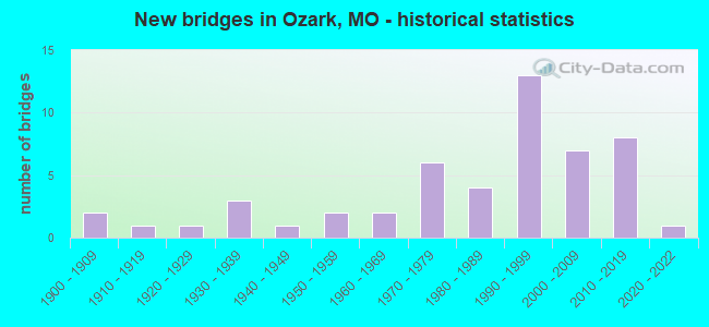
- New bridges - historical statistics
- 21900-1909
- 11910-1919
- 11920-1929
- 31930-1939
- 11940-1949
- 21950-1959
- 21960-1969
- 61970-1979
- 41980-1989
- 131990-1999
- 72000-2009
- 82010-2019
- 12020-2022
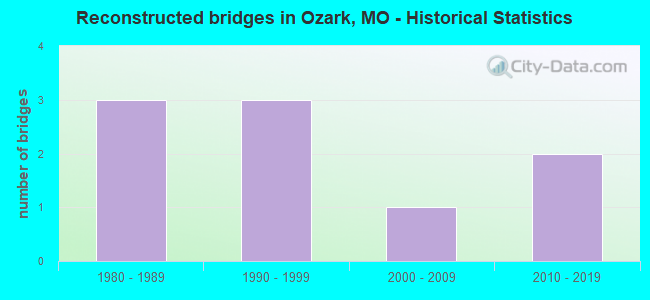
- Reconstructed bridges - Historical Statistics
- 31980-1989
- 31990-1999
- 12000-2009
- 22010-2019
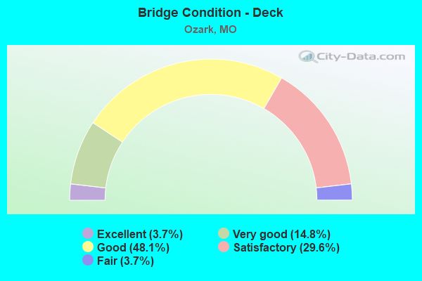
- Bridge Condition - Deck
- 3.7%Excellent
- 14.8%Very good
- 48.1%Good
- 29.6%Satisfactory
- 3.7%Fair
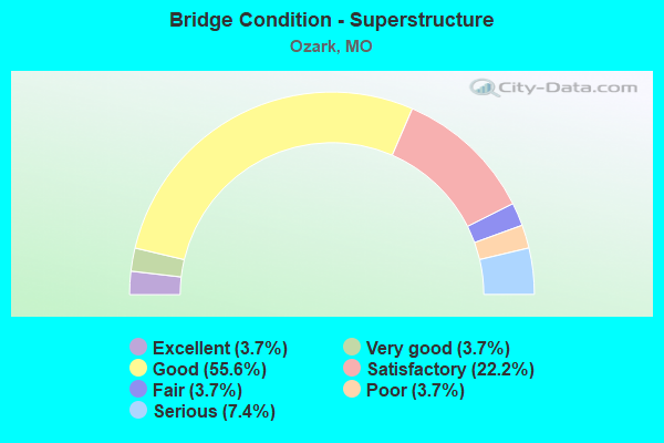
- Bridge Condition - Superstructure
- 3.7%Excellent
- 3.7%Very good
- 55.6%Good
- 22.2%Satisfactory
- 3.7%Fair
- 3.7%Poor
- 7.4%Serious
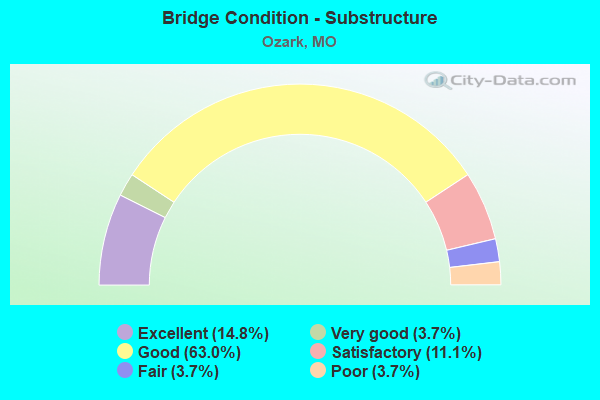
- Bridge Condition - Substructure
- 14.8%Excellent
- 3.7%Very good
- 63.0%Good
- 11.1%Satisfactory
- 3.7%Fair
- 3.7%Poor
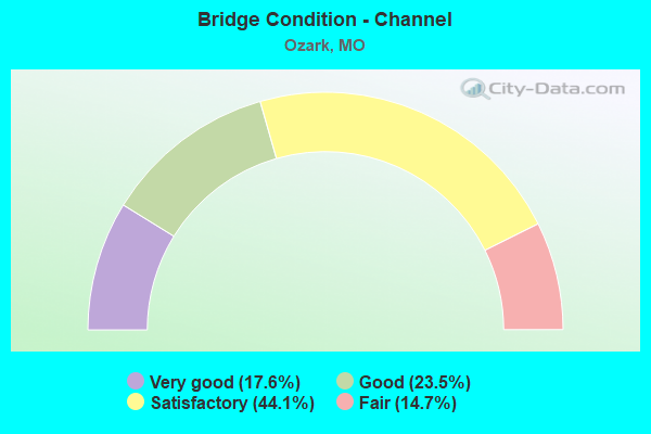
- Bridge Condition - Channel
- 17.6%Very good
- 23.5%Good
- 44.1%Satisfactory
- 14.7%Fair
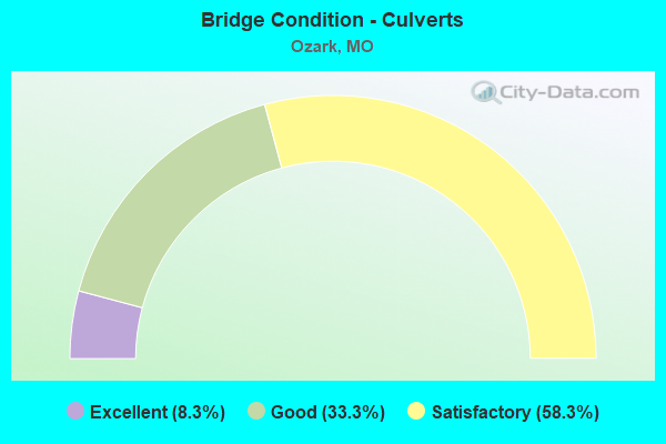
- Bridge Condition - Culverts
- 8.3%Excellent
- 33.3%Good
- 58.3%Satisfactory
Find on map >> Show street view
Structure Number: 3159, Location: S 21 T 26 N R 21 W (Lat: 36.943111, Lng: -93.232008), Route carried "under" structure: US 65, Year Built: 1996, Structure Length: 0. m, Average Daily Traffic: 15,708 (year 2021), Truck Traffic: 6%, Features Intersected: US 65, Facility Carried by Structure: RT EE E
Minimum Vertical Clearance: 5.18m (16.99ft), Kilometerpoint: 52.698, Lanes on structure: 3, Lanes under structure: 2, Material/Design: Steel continuous, Design/Construction: Stringer/Multi-beam, Length of Maximum Span: 33.8m (110.9ft)
Find on map >> Show street view
Structure Number: 3159, Location: S 21 T 26 N R 21 W (Lat: 36.943111, Lng: -93.232008), Route carried "under" structure: US 65, Year Built: 1996, Structure Length: 0. m, Average Daily Traffic: 14,870 (year 2021), Truck Traffic: 23%, Features Intersected: US 65, Facility Carried by Structure: RT EE E
Minimum Vertical Clearance: 5.18m (16.99ft), Kilometerpoint: 451.124, Lanes on structure: 3, Lanes under structure: 2, Material/Design: Steel continuous, Design/Construction: Stringer/Multi-beam, Length of Maximum Span: 33.8m (110.9ft)
Find on map >> Show street view
Structure Number: 3199, Location: S 3 T 27 N R 21 W (Lat: 37.070139, Lng: -93.228664), Route carried "under" structure: US 65, Year Built: 1987, Structure Length: 0. m, Average Daily Traffic: 29,849 (year 2021), Truck Traffic: 18%, Features Intersected: US 65, Facility Carried by Structure: RT J E
Minimum Vertical Clearance: 5.23m (17.16ft), Kilometerpoint: 437.009, Lanes on structure: 3, Lanes under structure: 2, Material/Design: Steel continuous, Design/Construction: Stringer/Multi-beam, Length of Maximum Span: 34.4m (112.9ft)
Find on map >> Show street view
Structure Number: 3199, Location: S 3 T 27 N R 21 W (Lat: 37.070139, Lng: -93.228664), Route carried "under" structure: US 65, Year Built: 1987, Structure Length: 0. m, Average Daily Traffic: 23,240 (year 2021), Truck Traffic: 10%, Features Intersected: US 65, Facility Carried by Structure: RT J E
Minimum Vertical Clearance: 5.46m (17.91ft), Kilometerpoint: 66.820, Lanes on structure: 3, Lanes under structure: 2, Material/Design: Steel continuous, Design/Construction: Stringer/Multi-beam, Length of Maximum Span: 34.4m (112.9ft)
Find on map >> Show street view
Structure Number: 35044, Location: S 3 T 27 N R 21 W (Lat: 37.070139, Lng: -93.228628), Route carried "under" structure: US 65, Year Built: 2016, Structure Length: 0. m, Average Daily Traffic: 23,478 (year 2021), Truck Traffic: 18%, Features Intersected: US 65, Facility Carried by Structure: RT J W
Minimum Vertical Clearance: 5.21m (17.09ft), Kilometerpoint: 437.028, Lanes on structure: 2, Lanes under structure: 2, Material/Design: Prestressed concrete, Design/Construction: Tee Beam, Length of Maximum Span: 34.1m (111.9ft)
Find on map >> Show street view
Structure Number: 35044, Location: S 3 T 27 N R 21 W (Lat: 37.070139, Lng: -93.228628), Route carried "under" structure: US 65, Year Built: 2016, Structure Length: 0. m, Average Daily Traffic: 23,240 (year 2021), Truck Traffic: 10%, Features Intersected: US 65, Facility Carried by Structure: RT J W
Minimum Vertical Clearance: 5.39m (17.68ft), Kilometerpoint: 66.801, Lanes on structure: 2, Lanes under structure: 2, Material/Design: Prestressed concrete, Design/Construction: Tee Beam, Length of Maximum Span: 34.1m (111.9ft)