Bridge Statistics for Paola, Kansas (KS)
Condition, Traffic, Stress, Structural Evaluation, Project Costs
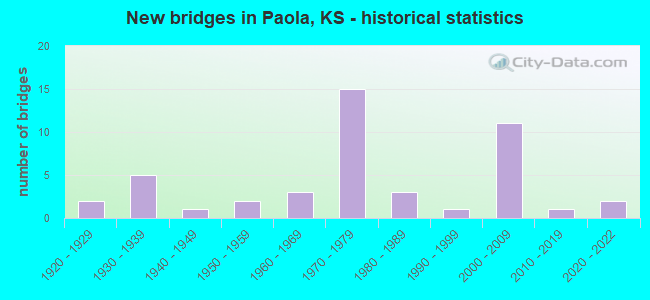
- New bridges - historical statistics
- 21920-1929
- 51930-1939
- 11940-1949
- 21950-1959
- 31960-1969
- 151970-1979
- 31980-1989
- 11990-1999
- 112000-2009
- 12010-2019
- 22020-2022
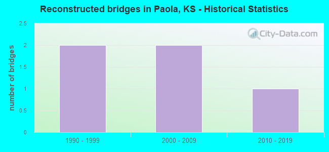
- Reconstructed bridges - Historical Statistics
- 21990-1999
- 22000-2009
- 12010-2019
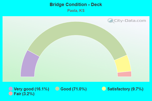
- Bridge Condition - Deck
- 16.1%Very good
- 71.0%Good
- 9.7%Satisfactory
- 3.2%Fair
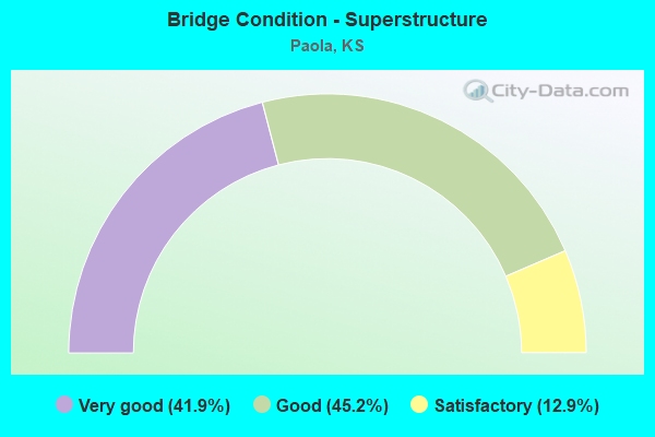
- Bridge Condition - Superstructure
- 41.9%Very good
- 45.2%Good
- 12.9%Satisfactory
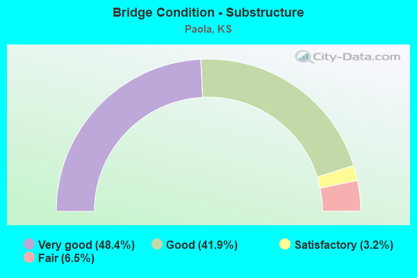
- Bridge Condition - Substructure
- 48.4%Very good
- 41.9%Good
- 3.2%Satisfactory
- 6.5%Fair
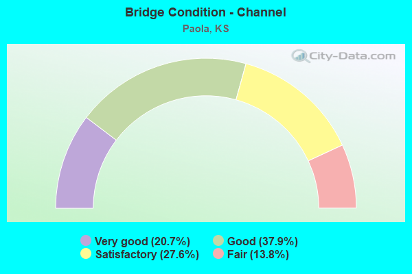
- Bridge Condition - Channel
- 20.7%Very good
- 37.9%Good
- 27.6%Satisfactory
- 13.8%Fair
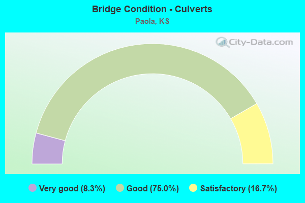
- Bridge Condition - Culverts
- 8.3%Very good
- 75.0%Good
- 16.7%Satisfactory
Find on map >> Show street view
Structure Number: 61003, Location: 0.5N 5.5E OF OSAWATOMIE (Lat: 38.505300, Lng: -94.853350), Route carried "on" structure: County highway 259, Year Built: 1962, Year Reconstructed: 2003, Status: Open, Structure Length: 9.29m (30.48ft), Average Daily Traffic: 680 (year 2011), Truck Traffic: 10%, Average Future Daily Traffic: 1,043 (year 2041), Design Load: HS 20, Features Intersected: BIG BULL CREEK
Minimum Vertical Clearance: 30.47m (99.97ft), Kilometerpoint: 19.690, Lanes on structure: 2, Owner: County Highway Agency, Approaching Roadway Width: 7.3m (24.0ft), Material/Design: Steel continuous, Design/Construction: Stringer/Multi-beam, Number Of Spans In Main Unit: 3, Length of Maximum Span: 35.4m (116.1ft), Curb-To-Curb Width: 7.9m (25.9ft), Out-to-Out Width: 8.5m (27.9ft)
Condition: Deck: Good, Superstructure: Good, Substructure: Good, Channel: Fair, Operating Rating: 45.4 metric tons, Method Used To Determine Operating Rating: Load Factor (LF), Inventory Rating: 27.2 metric tons, Method Used To Determine Inventory Rating: Load Factor (LF), Structural Evaluation: Equal to present minimum criteria, Deck Geometry: Somewhat better than minimum adequacy, Waterway Adequacy: Somewhat better than minimum adequacy, Approach Roadway Alignment: Equal to present desirable criteria, Designated Inspection Frequency: Every 24 months, Inspection Date: June 2021, Deck Structure Type: Concrete Cast-file-Place, Wearing Surface/Protective System: Deck Protection: Epoxy Coated Reinforcing
Find on map >> Show street view
Structure Number: 61015, Location: 3.2W 1.3N OF PAOLA (Lat: 38.589033, Lng: -94.936800), Route carried "on" structure: County highway 346, Year Built: 2002, Status: Open, Structure Length: 0.95m (3.12ft), Average Daily Traffic: 168 (year 2011), Truck Traffic: 10%, Average Future Daily Traffic: 330 (year 2041), Design Load: HS 20, Features Intersected: WALNUT CREEK, Facility Carried by Structure: Osawatomie Rd
Minimum Vertical Clearance: 30.47m (99.97ft), Kilometerpoint: 0.805, Lanes on structure: 2, Owner: County Highway Agency, Approaching Roadway Width: 7.3m (24.0ft), Skew: 4 degrees, Material/Design: Concrete, Design/Construction: Culvert, Number Of Spans In Main Unit: 3, Length of Maximum Span: 3.0m (9.8ft), Curb-To-Curb Width: 9.8m (32.2ft), Out-to-Out Width: 10.2m (33.5ft)
Condition: Channel: Fair, Culverts: Good, Operating Rating: 72.1 metric tons, Method Used To Determine Operating Rating: Load Factor (LF), Inventory Rating: 43.2 metric tons, Method Used To Determine Inventory Rating: Load Factor (LF), Structural Evaluation: Better than present minimum criteria, Deck Geometry: Better than present minimum criteria, Waterway Adequacy: Equal to present desirable criteria, Approach Roadway Alignment: Equal to present desirable criteria, Designated Inspection Frequency: Every 24 months, Inspection Date: June 2021, Deck Structure Type: Concrete Cast-file-Place, Wearing Surface/Protective System: Deck Protection: Epoxy Coated Reinforcing
Find on map >> Show street view
Structure Number: 610151, Location: 3.0W 0.9N OF PAOLA (Lat: 38.591450, Lng: -94.936769), Route carried "on" structure: County highway 346, Year Built: 1982, Status: Open, Structure Length: 2.35m (7.71ft), Average Daily Traffic: 168 (year 2011), Truck Traffic: 10%, Average Future Daily Traffic: 330 (year 2041), Design Load: H 20, Features Intersected: WALNUT CREEK, Facility Carried by Structure: Osawatomie Rd
Minimum Vertical Clearance: 30.47m (99.97ft), Kilometerpoint: 1.448, Lanes on structure: 2, Owner: County Highway Agency, Approaching Roadway Width: 7.3m (24.0ft), Material/Design: Concrete continuous, Design/Construction: Slab, Number Of Spans In Main Unit: 3, Length of Maximum Span: 9.1m (29.9ft), Curb-To-Curb Width: 7.9m (25.9ft), Out-to-Out Width: 8.5m (27.9ft)
Condition: Deck: Good, Superstructure: Good, Substructure: Good, Channel: Good, Operating Rating: 61.4 metric tons, Method Used To Determine Operating Rating: Load Factor (LF), Inventory Rating: 36.8 metric tons, Method Used To Determine Inventory Rating: Load Factor (LF), Structural Evaluation: Better than present minimum criteria, Deck Geometry: Somewhat better than minimum adequacy, Waterway Adequacy: Equal to present desirable criteria, Approach Roadway Alignment: Equal to present desirable criteria, Designated Inspection Frequency: Every 24 months, Inspection Date: June 2021, Deck Structure Type: Concrete Cast-file-Place
Find on map >> Show street view
Structure Number: 61028, Location: 1.3S 0.8E OF PAOLA (Lat: 38.553075, Lng: -94.863767), Route carried "on" structure: County highway 404, Year Built: 1976, Year Reconstructed: 2015, Status: Open, Structure Length: 8.02m (26.31ft), Average Daily Traffic: 1,920 (year 2011), Truck Traffic: 10%, Average Future Daily Traffic: 3,079 (year 2041), Design Load: HS 20, Features Intersected: BIG BULL CREEK, Facility Carried by Structure: Hospital Drive Rd
Minimum Vertical Clearance: 30.47m (99.97ft), Kilometerpoint: 5.327, Lanes on structure: 2, Owner: County Highway Agency, Approaching Roadway Width: 7.3m (24.0ft), Material/Design: Steel continuous, Design/Construction: Stringer/Multi-beam, Number Of Spans In Main Unit: 3, Length of Maximum Span: 30.5m (100.1ft), Curb-To-Curb Width: 8.6m (28.2ft), Out-to-Out Width: 9.1m (29.9ft)
Condition: Deck: Very good, Superstructure: Very good, Substructure: Good, Channel: Good, Operating Rating: 45.4 metric tons, Method Used To Determine Operating Rating: Allowable Stress (AS), Inventory Rating: 32.7 metric tons, Method Used To Determine Inventory Rating: Allowable Stress (AS), Structural Evaluation: Better than present minimum criteria, Deck Geometry: Somewhat better than minimum adequacy, Waterway Adequacy: Equal to present desirable criteria, Approach Roadway Alignment: Equal to present desirable criteria, Designated Inspection Frequency: Every 24 months, Inspection Date: May 2021, Deck Structure Type: Concrete Cast-file-Place, Wearing Surface/Protective System: Deck Protection: Epoxy Coated Reinforcing
Find on map >> Show street view
Structure Number: 610395, Location: SPILLWAY MIOLA LAKE (Lat: 38.582456, Lng: -94.845767), Route carried "on" structure: County highway 1021, Year Built: 1970, Status: Open, Structure Length: 2.59m (8.50ft), Average Daily Traffic: 368 (year 2011), Average Future Daily Traffic: 934 (year 2041), Features Intersected: BRANCH CREEK
Minimum Vertical Clearance: 30.47m (99.97ft), Kilometerpoint: 3.251, Lanes on structure: 2, Owner: County Highway Agency, Approaching Roadway Width: 7.9m (25.9ft), Material/Design: Concrete, Design/Construction: Culvert, Number Of Spans In Main Unit: 8, Length of Maximum Span: 3.0m (9.8ft), Curb-To-Curb Width: 7.9m (25.9ft), Out-to-Out Width: 8.5m (27.9ft)
Condition: Channel: Good, Culverts: Satisfactory, Operating Rating: 30.8 metric tons, Method Used To Determine Operating Rating: Allowable Stress (AS), Inventory Rating: 21.8 metric tons, Method Used To Determine Inventory Rating: Allowable Stress (AS), Structural Evaluation: Equal to present minimum criteria, Deck Geometry: Somewhat better than minimum adequacy, Waterway Adequacy: Equal to present desirable criteria, Approach Roadway Alignment: Somewhat better than minimum adequacy, Designated Inspection Frequency: Every 24 months, Inspection Date: May 2021, Wearing Surface/Protective System: Wearing Surface: Bituminous
Find on map >> Show street view
Structure Number: 6104, Location: 1.0N 3.7E OF PAOLA (Lat: 38.584811, Lng: -94.809331), Route carried "on" structure: County highway 1021, Year Built: 1988, Status: Open, Structure Length: 5.33m (17.49ft), Average Daily Traffic: 72 (year 2011), Average Future Daily Traffic: 126 (year 2041), Design Load: H 20, Features Intersected: NORTH WEA CREEK
Minimum Vertical Clearance: 30.47m (99.97ft), Kilometerpoint: 6.473, Lanes on structure: 2, Owner: County Highway Agency, Approaching Roadway Width: 7.3m (24.0ft), Material/Design: Prestressed concrete continuous, Design/Construction: Tee Beam, Number Of Spans In Main Unit: 3, Length of Maximum Span: 17.7m (58.1ft), Curb-To-Curb Width: 7.4m (24.3ft), Out-to-Out Width: 8.0m (26.2ft)
Condition: Deck: Good, Superstructure: Good, Substructure: Very good, Channel: Good, Operating Rating: 33.6 metric tons, Method Used To Determine Operating Rating: Allowable Stress (AS), Inventory Rating: 20.0 metric tons, Method Used To Determine Inventory Rating: Allowable Stress (AS), Structural Evaluation: Somewhat better than minimum adequacy, Deck Geometry: Equal to present minimum criteria, Waterway Adequacy: Better than present minimum criteria, Approach Roadway Alignment: Equal to present desirable criteria, Designated Inspection Frequency: Every 24 months, Inspection Date: May 2021, Deck Structure Type: Concrete Cast-file-Place
Find on map >> Show street view
Structure Number: 61041, Location: 1.1N 4.6E OF PAOLA (Lat: 38.586756, Lng: -94.793081), Route carried "on" structure: County highway 1021, Year Built: 1995, Status: Open, Structure Length: 3.73m (12.24ft), Average Daily Traffic: 72 (year 2011), Average Future Daily Traffic: 126 (year 2041), Design Load: HS 20, Features Intersected: NORTH WEA CREEK, Facility Carried by Structure: 299th Street
Minimum Vertical Clearance: 30.47m (99.97ft), Kilometerpoint: 7.953, Lanes on structure: 2, Owner: County Highway Agency, Approaching Roadway Width: 7.6m (24.9ft), Skew: 3 degrees, Material/Design: Concrete continuous, Design/Construction: Slab, Number Of Spans In Main Unit: 3, Length of Maximum Span: 14.6m (47.9ft), Curb-To-Curb Width: 8.5m (27.9ft), Out-to-Out Width: 9.1m (29.9ft)
Condition: Deck: Good, Superstructure: Very good, Substructure: Very good, Channel: Very good, Operating Rating: 68.6 metric tons, Method Used To Determine Operating Rating: Load Factor (LF), Inventory Rating: 41.1 metric tons, Method Used To Determine Inventory Rating: Load Factor (LF), Structural Evaluation: Equal to present desirable criteria, Deck Geometry: Better than present minimum criteria, Waterway Adequacy: Equal to present desirable criteria, Approach Roadway Alignment: Equal to present desirable criteria, Designated Inspection Frequency: Every 24 months, Inspection Date: May 2021, Deck Structure Type: Concrete Cast-file-Place
Find on map >> Show street view
Structure Number: 61049, Location: 0.3N 1.0W OF PAOLA (Lat: 38.576506, Lng: -94.895836), Route carried "on" structure: County highway 1027, Year Built: 1958, Year Reconstructed: 2014, Status: Open, Structure Length: 8.82m (28.94ft), Average Daily Traffic: 562 (year 2011), Truck Traffic: 10%, Average Future Daily Traffic: 2,910 (year 2041), Design Load: HL 93, Features Intersected: BULL CREEK, Facility Carried by Structure: 303rd Street
Minimum Vertical Clearance: 30.47m (99.97ft), Kilometerpoint: 6.762, Lanes on structure: 2, Owner: County Highway Agency, Approaching Roadway Width: 7.6m (24.9ft), Material/Design: Prestressed concrete, Design/Construction: Stringer/Multi-beam, Number Of Spans In Main Unit: 4, Length of Maximum Span: 24.7m (81.0ft), Curb-To-Curb Width: 8.5m (27.9ft), Out-to-Out Width: 9.1m (29.9ft)
Condition: Deck: Good, Superstructure: Very good, Substructure: Good, Channel: Satisfactory, Operating Rating: 36.3 metric tons, Method Used To Determine Operating Rating: Allowable Stress (AS), Inventory Rating: 34.5 metric tons, Method Used To Determine Inventory Rating: Allowable Stress (AS), Structural Evaluation: Better than present minimum criteria, Deck Geometry: Somewhat better than minimum adequacy, Waterway Adequacy: Equal to present desirable criteria, Approach Roadway Alignment: Equal to present desirable criteria, Designated Inspection Frequency: Every 24 months, Inspection Date: June 2021, Deck Structure Type: Concrete Precast Panels, Wearing Surface/Protective System: Wearing Surface: Monolithic Concrete, Deck Protection: Epoxy Coated Reinforcing
Find on map >> Show street view
Structure Number: 61056, Location: 1.2W 0.5N OF PAOLA (Lat: 38.582611, Lng: -94.900725), Route carried "on" structure: County highway 1384, Year Built: 1931, Status: Open, Structure Length: 2.29m (7.51ft), Average Daily Traffic: 672 (year 2011), Truck Traffic: 10%, Average Future Daily Traffic: 5,756 (year 2041), Features Intersected: BELL BRANCH CREEK, Facility Carried by Structure: LONE STAR Rd
Minimum Vertical Clearance: 30.47m (99.97ft), Kilometerpoint: 0.483, Lanes on structure: 2, Owner: County Highway Agency, Approaching Roadway Width: 6.8m (22.3ft), Material/Design: Concrete, Design/Construction: Tee Beam, Number Of Spans In Main Unit: 2, Length of Maximum Span: 11.0m (36.1ft), Curb-To-Curb Width: 7.6m (24.9ft), Out-to-Out Width: 8.2m (26.9ft)
Condition: Deck: Satisfactory, Superstructure: Satisfactory, Substructure: Fair, Channel: Fair, Operating Rating: 36.3 metric tons, Method Used To Determine Operating Rating: Allowable Stress (AS), Inventory Rating: 27.2 metric tons, Method Used To Determine Inventory Rating: Allowable Stress (AS), Structural Evaluation: Somewhat better than minimum adequacy, Deck Geometry: Meets minimum limits, Waterway Adequacy: Meets minimum limits, Approach Roadway Alignment: Equal to present minimum criteria, Designated Inspection Frequency: Every 24 months, Inspection Date: June 2021, Deck Structure Type: Concrete Cast-file-Place, Wearing Surface/Protective System: Wearing Surface: Bituminous
Find on map >> Show street view
Structure Number: 610587, Location: 1.0S 0.2W OF PAOLA (Lat: 38.561597, Lng: -94.884386), Route carried "on" structure: County highway 1604, Year Built: 1936, Year Reconstructed: 2011, Status: Posted for load, Structure Length: 14.87m (48.79ft), Average Daily Traffic: 4,479 (year 2011), Truck Traffic: 10%, Average Future Daily Traffic: 102,333 (year 2041), Features Intersected: BIG BULL CREEK AND R.R., Facility Carried by Structure: Old KC Road
Minimum Vertical Clearance: 30.47m (99.97ft), Kilometerpoint: 28.658, Lanes on structure: 2, Owner: County Highway Agency, Approaching Roadway Width: 8.5m (27.9ft), Material/Design: Concrete, Design/Construction: Arch - Deck, Number Of Spans In Main Unit: 5, Length of Maximum Span: 42.7m (140.1ft), Curb-To-Curb Width: 8.5m (27.9ft), Out-to-Out Width: 70.3m (230.6ft)
Condition: Deck: Good, Superstructure: Good, Substructure: Very good, Channel: Good, Operating Rating: 21.5 metric tons, Method Used To Determine Operating Rating: Load Factor (LF), Inventory Rating: 12.9 metric tons, Method Used To Determine Inventory Rating: Load Factor (LF), Structural Evaluation: Meets minimum limits, Deck Geometry: Meets minimum limits, Underclear: Superior to present desirable criteria, Waterway Adequacy: Equal to present desirable criteria, Approach Roadway Alignment: Equal to present minimum criteria, Bridge Posting: Required (Relationship of Operating Rating to Maximum Legal Load: 10.0 - 19.9% below), Length Of Structure Improvement: 17.31m (56.79ft), Designated Inspection Frequency: Every 24 months, Inspection Date: June 2021, Bridge Improvement Cost: $200,000, Roadway Improvement Cost: $295,000, Total Project Cost: $230,000, Deck Structure Type: Concrete Cast-file-Place, Wearing Surface/Protective System: Wearing Surface: Monolithic Concrete, Deck Protection: Epoxy Coated Reinforcing
Find on map >> Show street view
Structure Number: 610588, Location: N. EDGE OF PAOLA (Lat: 38.579889, Lng: -94.875344), Route carried "on" structure: County highway 1604, Year Built: 1935, Status: Open, Structure Length: 0.87m (2.85ft), Average Daily Traffic: 766 (year 2011), Truck Traffic: 10%, Average Future Daily Traffic: 13,546 (year 2041), Features Intersected: TRIB. TO TEN MILE CREEK
Minimum Vertical Clearance: 30.47m (99.97ft), Kilometerpoint: 30.590, Lanes on structure: 2, Owner: County Highway Agency, Approaching Roadway Width: 12.1m (39.7ft), Material/Design: Concrete, Design/Construction: Culvert, Number Of Spans In Main Unit: 3, Length of Maximum Span: 2.7m (8.9ft)
Condition: Channel: Satisfactory, Culverts: Satisfactory, Operating Rating: 45.4 metric tons, Method Used To Determine Operating Rating: Allowable Stress (AS), Inventory Rating: 28.1 metric tons, Method Used To Determine Inventory Rating: Allowable Stress (AS), Structural Evaluation: Equal to present minimum criteria, Waterway Adequacy: Equal to present desirable criteria, Approach Roadway Alignment: Better than present minimum criteria, Designated Inspection Frequency: Every 24 months, Inspection Date: June 2021, Wearing Surface/Protective System: Wearing Surface: Bituminous
Find on map >> Show street view
Structure Number: 610592, Location: 0.6S 1.7E OF PAOLA (Lat: 38.563314, Lng: -94.846456), Route carried "on" structure: County highway 1705, Year Built: 1983, Status: Open, Structure Length: 7.25m (23.79ft), Average Daily Traffic: 1,804 (year 2011), Truck Traffic: 10%, Average Future Daily Traffic: 8,171 (year 2041), Design Load: HS 20, Features Intersected: DORSEY BR. OF S. WEA, Facility Carried by Structure: 311th Street
Minimum Vertical Clearance: 30.47m (99.97ft), Kilometerpoint: 1.481, Lanes on structure: 2, Owner: County Highway Agency, Approaching Roadway Width: 6.4m (21.0ft), Skew: 3 degrees, Material/Design: Steel continuous, Design/Construction: Stringer/Multi-beam, Number Of Spans In Main Unit: 3, Length of Maximum Span: 28.0m (91.9ft), Curb-To-Curb Width: 8.6m (28.2ft), Out-to-Out Width: 9.2m (30.2ft)
Condition: Deck: Good, Superstructure: Very good, Substructure: Good, Channel: Good, Operating Rating: 62.6 metric tons, Method Used To Determine Operating Rating: Allowable Stress (AS), Inventory Rating: 39.9 metric tons, Method Used To Determine Inventory Rating: Allowable Stress (AS), Structural Evaluation: Better than present minimum criteria, Deck Geometry: Somewhat better than minimum adequacy, Waterway Adequacy: Equal to present desirable criteria, Approach Roadway Alignment: Equal to present minimum criteria, Designated Inspection Frequency: Every 24 months, Inspection Date: May 2021, Deck Structure Type: Concrete Cast-file-Place, Wearing Surface/Protective System: Wearing Surface: Epoxy Overlay
Find on map >> Show street view
Structure Number: 610594, Location: .4 N of 311th on Baptiste (Lat: 38.566025, Lng: -94.848514), Route carried "on" structure: City street , Year Built: 2003, Status: Open, Structure Length: 1.12m (3.67ft), Average Daily Traffic: 1,585 (year 2011), Truck Traffic: 10%, Average Future Daily Traffic: 3,973 (year 2041), Design Load: HS 20, Features Intersected: Trib to South Wea Creek, Facility Carried by Structure: Baptiste Dr 1027
Minimum Vertical Clearance: 30.47m (99.97ft), Kilometerpoint: 0.000, Lanes on structure: 4, Owner: City or Municipal Highway Agency, Approaching Roadway Width: 22.3m (73.2ft), Skew: 4 degrees, Material/Design: Concrete, Design/Construction: Culvert, Number Of Spans In Main Unit: 3, Length of Maximum Span: 3.4m (11.2ft), Curb-To-Curb Width: 16.5m (54.1ft), Out-to-Out Width: 50.2m (164.7ft)
Condition: Channel: Good, Culverts: Good, Operating Rating: 31.8 metric tons, Method Used To Determine Operating Rating: Allowable Stress (AS), Inventory Rating: 21.8 metric tons, Method Used To Determine Inventory Rating: Allowable Stress (AS), Structural Evaluation: Somewhat better than minimum adequacy, Deck Geometry: Meets minimum limits, Waterway Adequacy: Equal to present desirable criteria, Approach Roadway Alignment: Equal to present desirable criteria, Designated Inspection Frequency: Every 24 months, Inspection Date: May 2021, Wearing Surface/Protective System: Wearing Surface: Bituminous
Find on map >> Show street view
Structure Number: 6106, Location: 0.6S 3.0E OF PAOLA (Lat: 38.563214, Lng: -94.821633), Route carried "on" structure: County highway 1705, Year Built: 1954, Status: Open, Structure Length: 1.07m (3.51ft), Average Daily Traffic: 1,585 (year 2011), Truck Traffic: 10%, Average Future Daily Traffic: 3,576 (year 2041), Design Load: H 15, Features Intersected: TRIB. TO SOUTH WEA CREEK, Facility Carried by Structure: 311th Street
Minimum Vertical Clearance: 30.47m (99.97ft), Kilometerpoint: 0.365, Lanes on structure: 2, Owner: County Highway Agency, Approaching Roadway Width: 7.6m (24.9ft), Skew: 3 degrees, Material/Design: Concrete, Design/Construction: Culvert, Number Of Spans In Main Unit: 2, Length of Maximum Span: 5.2m (17.1ft), Curb-To-Curb Width: 8.7m (28.5ft), Out-to-Out Width: 8.7m (28.5ft)
Condition: Channel: Good, Culverts: Good, Operating Rating: 31.8 metric tons, Method Used To Determine Operating Rating: Allowable Stress (AS), Inventory Rating: 22.7 metric tons, Method Used To Determine Inventory Rating: Allowable Stress (AS), Structural Evaluation: Equal to present minimum criteria, Deck Geometry: Somewhat better than minimum adequacy, Waterway Adequacy: Equal to present desirable criteria, Approach Roadway Alignment: Equal to present desirable criteria, Designated Inspection Frequency: Every 24 months, Inspection Date: May 2021, Wearing Surface/Protective System: Wearing Surface: Bituminous
Find on map >> Show street view
Structure Number: 61071, Location: 0.2N 1.8E OF PAOLA (Lat: 38.585139, Lng: -94.825306), Route carried "on" structure: County highway 1021, Year Built: 2021, Status: Open, Structure Length: 1.07m (3.51ft), Average Daily Traffic: 80 (year 2021), Truck Traffic: 5%, Average Future Daily Traffic: 120 (year 2041), Design Load: HL 93, Features Intersected: TRIB. TO SOUTH WEA CREEK, Facility Carried by Structure: 299th Street
Minimum Vertical Clearance: 30.47m (99.97ft), Kilometerpoint: 0.000, Lanes on structure: 2, Owner: County Highway Agency, Approaching Roadway Width: 7.4m (24.3ft), Material/Design: Steel, Design/Construction: Stringer/Multi-beam, Number Of Spans In Main Unit: 1, Length of Maximum Span: 9.4m (30.8ft), Curb-To-Curb Width: 7.9m (25.9ft), Out-to-Out Width: 8.5m (27.9ft)
Condition: Deck: Very good, Superstructure: Very good, Substructure: Very good, Channel: Very good, Operating Rating: 59.6 metric tons, Method Used To Determine Operating Rating: Load and Resistance Factor Rating (LRFR) rating reported by rating factor(RF) method using HL-93 loadings, Inventory Rating: 46.0 metric tons, Method Used To Determine Inventory Rating: Load and Resistance Factor Rating (LRFR) rating reported by rating factor(RF) method using HL-93 loadings, Structural Evaluation: Equal to present desirable criteria, Deck Geometry: Equal to present minimum criteria, Waterway Adequacy: Equal to present desirable criteria, Approach Roadway Alignment: Equal to present desirable criteria, Designated Inspection Frequency: Every 24 months, Inspection Date: November 2021, Deck Structure Type: Concrete Cast-file-Place, Wearing Surface/Protective System: Deck Protection: Epoxy Coated Reinforcing
Find on map >> Show street view
Structure Number: 61B39, Location: 1.3S 1.3E OF PAOLA (Lat: 38.553372, Lng: -94.854453), Route carried "on" structure: County highway 1019, Year Built: 2020, Status: Open, Structure Length: 9.14m (29.99ft), Average Daily Traffic: 1,148 (year 2011), Average Future Daily Traffic: 1,148 (year 2043), Design Load: HL 93, Features Intersected: BULL CREEK, Facility Carried by Structure: Hedge Lane Rd
Minimum Vertical Clearance: 30.47m (99.97ft), Kilometerpoint: 0.000, Lanes on structure: 2, Owner: County Highway Agency, Approaching Roadway Width: 6.7m (22.0ft), Material/Design: Prestressed concrete continuous, Design/Construction: Stringer/Multi-beam, Number Of Spans In Main Unit: 3, Length of Maximum Span: 36.6m (120.1ft), Curb-To-Curb Width: 8.5m (27.9ft), Out-to-Out Width: 9.1m (29.9ft)
Condition: Deck: Very good, Superstructure: Very good, Substructure: Very good, Channel: Good, Operating Rating: 36.9 metric tons, Method Used To Determine Operating Rating: Load and Resistance Factor Rating (LRFR) rating reported by rating factor(RF) method using HL-93 loadings, Inventory Rating: 34.0 metric tons, Method Used To Determine Inventory Rating: Load and Resistance Factor Rating (LRFR) rating reported by rating factor(RF) method using HL-93 loadings, Structural Evaluation: Equal to present desirable criteria, Deck Geometry: Somewhat better than minimum adequacy, Waterway Adequacy: Equal to present desirable criteria, Approach Roadway Alignment: Equal to present desirable criteria, Designated Inspection Frequency: Every 24 months, Inspection Date: May 2021, Deck Structure Type: Concrete Cast-file-Place
Find on map >> Show street view
Structure Number: 61107930492, Location: 2.0N 2.7W OF PAOLA (Lat: 38.607142, Lng: -94.931364), Route carried "on" structure: County highway , Year Built: 1935, Status: Posted for load, Structure Length: 1.31m (4.30ft), Average Daily Traffic: 580 (year 2011), Truck Traffic: 10%, Average Future Daily Traffic: 819 (year 2041), Features Intersected: TRIB. TO WALNUT CREEK, Facility Carried by Structure: 287th Street
Minimum Vertical Clearance: 30.47m (99.97ft), Kilometerpoint: 0.000, Lanes on structure: 2, Owner: County Highway Agency, Approaching Roadway Width: 6.5m (21.3ft), Skew: 3 degrees, Material/Design: Concrete, Design/Construction: Tee Beam, Number Of Spans In Main Unit: 1, Length of Maximum Span: 12.5m (41.0ft), Curb-To-Curb Width: 7.4m (24.3ft), Out-to-Out Width: 8.3m (27.2ft)
Condition: Deck: Satisfactory, Superstructure: Satisfactory, Substructure: Satisfactory, Channel: Satisfactory, Operating Rating: 22.7 metric tons, Method Used To Determine Operating Rating: Field evaluation and documented engineering judgment, Inventory Rating: 22.7 metric tons, Method Used To Determine Inventory Rating: Field evaluation and documented engineering judgment, Structural Evaluation: Equal to present minimum criteria, Deck Geometry: Meets minimum limits, Waterway Adequacy: Equal to present desirable criteria, Approach Roadway Alignment: Equal to present minimum criteria, Bridge Posting: Required (Relationship of Operating Rating to Maximum Legal Load: > 39.9% below), Designated Inspection Frequency: Every 24 months, Inspection Date: June 2021, Deck Structure Type: Concrete Cast-file-Place, Wearing Surface/Protective System: Wearing Surface: Bituminous
Find on map >> Show street view
Structure Number: 611081004929, Location: 2.0W 1.1N OF PAOLA (Lat: 38.594794, Lng: -94.918483), Route carried "on" structure: County highway , Year Built: 1920, Status: Open, Structure Length: 1.46m (4.79ft), Average Daily Traffic: 52 (year 2011), Average Future Daily Traffic: 172 (year 2041), Features Intersected: WALNUT CREEK, Facility Carried by Structure: Lookout Road
Minimum Vertical Clearance: 30.47m (99.97ft), Kilometerpoint: 0.000, Lanes on structure: 1, Owner: County Highway Agency, Approaching Roadway Width: 5.7m (18.7ft), Material/Design: Concrete, Design/Construction: Culvert, Number Of Spans In Main Unit: 1, Length of Maximum Span: 12.8m (42.0ft), Curb-To-Curb Width: 4.1m (13.5ft), Out-to-Out Width: 4.8m (15.7ft)
Condition: Channel: Satisfactory, Culverts: Good, Operating Rating: 30.8 metric tons, Method Used To Determine Operating Rating: Allowable Stress (AS), Inventory Rating: 20.0 metric tons, Method Used To Determine Inventory Rating: Allowable Stress (AS), Structural Evaluation: Somewhat better than minimum adequacy, Deck Geometry: Somewhat better than minimum adequacy, Waterway Adequacy: Somewhat better than minimum adequacy, Approach Roadway Alignment: Somewhat better than minimum adequacy, Designated Inspection Frequency: Every 24 months, Inspection Date: June 2021, Wearing Surface/Protective System: Wearing Surface: Bituminous
Find on map >> Show street view
Structure Number: 611083604984, Location: 0.9S 0.3W OF PAOLA (Lat: 38.559408, Lng: -94.886217), Route carried "on" structure: County highway , Year Built: 1927, Status: Open, Structure Length: 0.91m (2.99ft), Average Daily Traffic: 8 (year 2011), Average Future Daily Traffic: 45 (year 2041), Features Intersected: TRIB. TO BIG BULL CREEK, Facility Carried by Structure: Santa Fe Drive
Minimum Vertical Clearance: 30.47m (99.97ft), Kilometerpoint: 0.000, Lanes on structure: 2, Owner: County Highway Agency, Approaching Roadway Width: 6.0m (19.7ft), Material/Design: Concrete, Design/Construction: Culvert, Number Of Spans In Main Unit: 3, Length of Maximum Span: 2.4m (7.9ft), Curb-To-Curb Width: 8.1m (26.6ft), Out-to-Out Width: 9.0m (29.5ft)
Condition: Channel: Satisfactory, Culverts: Good, Operating Rating: 45.4 metric tons, Method Used To Determine Operating Rating: Allowable Stress (AS), Inventory Rating: 28.1 metric tons, Method Used To Determine Inventory Rating: Allowable Stress (AS), Structural Evaluation: Better than present minimum criteria, Deck Geometry: Equal to present minimum criteria, Waterway Adequacy: Equal to present desirable criteria, Approach Roadway Alignment: Equal to present desirable criteria, Designated Inspection Frequency: Every 24 months, Inspection Date: June 2021, Wearing Surface/Protective System: Wearing Surface: Gravel
Find on map >> Show street view
Structure Number: 61108500492, Location: 2.4N 0.2W OF PAOLA (Lat: 38.606897, Lng: -94.884058), Route carried "on" structure: County highway , Year Built: 2000, Status: Open, Structure Length: 6.75m (22.15ft), Average Daily Traffic: 548 (year 2011), Truck Traffic: 10%, Average Future Daily Traffic: 3,425 (year 2041), Design Load: HS 20, Features Intersected: BIG BULL CREEK, Facility Carried by Structure: 287th Street
Minimum Vertical Clearance: 30.47m (99.97ft), Kilometerpoint: 0.000, Lanes on structure: 2, Owner: County Highway Agency, Approaching Roadway Width: 7.0m (23.0ft), Material/Design: Prestressed concrete continuous, Design/Construction: Stringer/Multi-beam, Number Of Spans In Main Unit: 3, Length of Maximum Span: 30.5m (100.1ft), Curb-To-Curb Width: 9.9m (32.5ft), Out-to-Out Width: 10.4m (34.1ft)
Condition: Deck: Good, Superstructure: Very good, Substructure: Very good, Channel: Very good, Operating Rating: 90.6 metric tons, Method Used To Determine Operating Rating: Load Factor (LF), Inventory Rating: 66.7 metric tons, Method Used To Determine Inventory Rating: Load Factor (LF), Structural Evaluation: Equal to present desirable criteria, Deck Geometry: Equal to present minimum criteria, Waterway Adequacy: Somewhat better than minimum adequacy, Approach Roadway Alignment: Equal to present desirable criteria, Designated Inspection Frequency: Every 24 months, Inspection Date: June 2021, Deck Structure Type: Concrete Cast-file-Place, Wearing Surface/Protective System: Deck Protection: Epoxy Coated Reinforcing
Find on map >> Show street view
Structure Number: 61108520492, Location: 2.4N 0.1W OF PAOLA (Lat: 38.606942, Lng: -94.880369), Route carried "on" structure: County highway , Year Built: 1940, Status: Open, Structure Length: 0.89m (2.92ft), Average Daily Traffic: 548 (year 2011), Truck Traffic: 10%, Average Future Daily Traffic: 3,425 (year 2041), Design Load: HS 20, Features Intersected: TRIB. TO BULL CREEK, Facility Carried by Structure: 287th Street
Minimum Vertical Clearance: 30.47m (99.97ft), Kilometerpoint: 0.000, Lanes on structure: 2, Owner: County Highway Agency, Approaching Roadway Width: 7.3m (24.0ft), Material/Design: Concrete, Design/Construction: Culvert, Number Of Spans In Main Unit: 3, Length of Maximum Span: 2.7m (8.9ft), Curb-To-Curb Width: 9.8m (32.2ft), Out-to-Out Width: 10.4m (34.1ft)
Condition: Channel: Satisfactory, Culverts: Good, Operating Rating: 46.3 metric tons, Method Used To Determine Operating Rating: Allowable Stress (AS), Inventory Rating: 28.1 metric tons, Method Used To Determine Inventory Rating: Allowable Stress (AS), Structural Evaluation: Better than present minimum criteria, Deck Geometry: Equal to present minimum criteria, Waterway Adequacy: Better than present minimum criteria, Approach Roadway Alignment: Equal to present desirable criteria, Length Of Structure Improvement: 0.85m (2.79ft), Designated Inspection Frequency: Every 24 months, Inspection Date: June 2021, Bridge Improvement Cost: $80,000, Roadway Improvement Cost: $25,000, Total Project Cost: $110,000, Wearing Surface/Protective System: Wearing Surface: Bituminous
Find on map >> Show street view
Structure Number: 61108910492, Location: 2.0N 2.0E OF PAOLA (Lat: 38.606839, Lng: -94.843819), Route carried "on" structure: County highway , Year Built: 1935, Status: Open, Structure Length: 1.30m (4.27ft), Average Daily Traffic: 589 (year 2011), Truck Traffic: 5%, Average Future Daily Traffic: 4,111 (year 2041), Features Intersected: TRIB. TO BIG BULL CREEK, Facility Carried by Structure: 287th Street
Minimum Vertical Clearance: 30.47m (99.97ft), Kilometerpoint: 0.000, Lanes on structure: 2, Owner: County Highway Agency, Approaching Roadway Width: 6.4m (21.0ft), Material/Design: Concrete, Design/Construction: Tee Beam, Number Of Spans In Main Unit: 1, Length of Maximum Span: 12.5m (41.0ft), Curb-To-Curb Width: 7.3m (24.0ft), Out-to-Out Width: 8.3m (27.2ft)
Condition: Deck: Satisfactory, Superstructure: Satisfactory, Substructure: Fair, Channel: Fair, Operating Rating: 30.8 metric tons, Method Used To Determine Operating Rating: Allowable Stress (AS), Inventory Rating: 20.0 metric tons, Method Used To Determine Inventory Rating: Allowable Stress (AS), Structural Evaluation: Somewhat better than minimum adequacy, Deck Geometry: Meets minimum limits, Waterway Adequacy: Equal to present desirable criteria, Approach Roadway Alignment: Equal to present minimum criteria, Length Of Structure Improvement: 1.83m (6.00ft), Designated Inspection Frequency: Every 24 months, Inspection Date: June 2021, Bridge Improvement Cost: $450,000, Roadway Improvement Cost: $145,000, Total Project Cost: $600,000, Deck Structure Type: Concrete Cast-file-Place, Wearing Surface/Protective System: Wearing Surface: Bituminous
Find on map >> Show street view
Structure Number: 611091005005, Location: 2.3S 2.8E OF PAOLA (Lat: 38.540869, Lng: -94.826550), Route carried "on" structure: County highway , Year Built: 2008, Status: Open, Structure Length: 0.97m (3.18ft), Average Daily Traffic: 137 (year 2011), Average Future Daily Traffic: 140 (year 2041), Design Load: HS 20, Features Intersected: TRIB. MARAIS DES CYGNES, Facility Carried by Structure: Victory Road
Minimum Vertical Clearance: 30.47m (99.97ft), Kilometerpoint: 0.000, Lanes on structure: 2, Owner: County Highway Agency, Approaching Roadway Width: 6.0m (19.7ft), Material/Design: Concrete, Design/Construction: Culvert, Number Of Spans In Main Unit: 3, Length of Maximum Span: 3.0m (9.8ft)
Condition: Channel: Good, Culverts: Good, Operating Rating: 68.6 metric tons, Method Used To Determine Operating Rating: Load Factor (LF), Inventory Rating: 41.0 metric tons, Method Used To Determine Inventory Rating: Load Factor (LF), Structural Evaluation: Better than present minimum criteria, Waterway Adequacy: Equal to present desirable criteria, Approach Roadway Alignment: Equal to present desirable criteria, Designated Inspection Frequency: Every 24 months, Inspection Date: June 2021, Wearing Surface/Protective System: Wearing Surface: Gravel
Find on map >> Show street view
Structure Number: 61109500492, Location: 0.9W OF SOMERSET (Lat: 38.606611, Lng: -94.786033), Route carried "on" structure: County highway , Year Built: 1960, Status: Open, Structure Length: 3.23m (10.60ft), Average Daily Traffic: 253 (year 2011), Average Future Daily Traffic: 738 (year 2041), Features Intersected: NORTH WEA CREEK, Facility Carried by Structure: 287th Street
Minimum Vertical Clearance: 30.47m (99.97ft), Kilometerpoint: 0.000, Lanes on structure: 2, Owner: County Highway Agency, Approaching Roadway Width: 6.7m (22.0ft), Material/Design: Prestressed concrete, Design/Construction: Tee Beam, Number Of Spans In Main Unit: 2, Length of Maximum Span: 15.8m (51.8ft), Curb-To-Curb Width: 7.3m (24.0ft), Out-to-Out Width: 7.9m (25.9ft)
Condition: Deck: Good, Superstructure: Very good, Substructure: Good, Channel: Satisfactory, Operating Rating: 45.4 metric tons, Method Used To Determine Operating Rating: Allowable Stress (AS), Inventory Rating: 28.1 metric tons, Method Used To Determine Inventory Rating: Allowable Stress (AS), Structural Evaluation: Better than present minimum criteria, Deck Geometry: Somewhat better than minimum adequacy, Waterway Adequacy: Equal to present desirable criteria, Approach Roadway Alignment: Equal to present desirable criteria, Designated Inspection Frequency: Every 24 months, Inspection Date: May 2021, Deck Structure Type: Concrete Cast-file-Place, Wearing Surface/Protective System: Wearing Surface: Bituminous
Find on map >> Show street view
Structure Number: 611095004946, Location: 2.6S 6.0W of Louisburg (Lat: 38.585147, Lng: -94.787461), Route carried "on" structure: County highway 439, Year Built: 2015, Status: Open, Structure Length: 1.34m (4.40ft), Average Daily Traffic: 61 (year 2011), Average Future Daily Traffic: 70 (year 2041), Design Load: HS 20, Features Intersected: TRIB. TO SOUTH WEA CREEK, Facility Carried by Structure: Oak Grove Road
Minimum Vertical Clearance: 30.47m (99.97ft), Kilometerpoint: 0.000, Lanes on structure: 2, Owner: County Highway Agency, Approaching Roadway Width: 6.8m (22.3ft), Material/Design: Concrete, Design/Construction: Culvert, Number Of Spans In Main Unit: 2, Length of Maximum Span: 9.2m (30.2ft), Curb-To-Curb Width: 7.6m (24.9ft), Out-to-Out Width: 7.9m (25.9ft)
Condition: Channel: Very good, Culverts: Very good, Operating Rating: 36.3 metric tons, Method Used To Determine Operating Rating: Load and Resistance Factor (LRFR), Inventory Rating: 32.7 metric tons, Method Used To Determine Inventory Rating: Load and Resistance Factor (LRFR), Structural Evaluation: Equal to present desirable criteria, Deck Geometry: Equal to present minimum criteria, Waterway Adequacy: Equal to present minimum criteria, Approach Roadway Alignment: Equal to present minimum criteria, Designated Inspection Frequency: Every 24 months, Inspection Date: May 2021, Wearing Surface/Protective System: Wearing Surface: Gravel
Find on map >> Show street view
Structure Number: 999906800610251, Location: 0.39 MI W OF US-169 (Lat: 38.621111, Lng: -94.843056), Route carried "on" structure: State highway 68, Year Built: 1968, Status: Open, Structure Length: 3.74m (12.27ft), Average Daily Traffic: 3,591 (year 2020), Truck Traffic: 19%, Average Future Daily Traffic: 5,336 (year 2041), Design Load: HS 20, Features Intersected: UP RAILROAD
Minimum Vertical Clearance: 30.47m (99.97ft), Kilometerpoint: 19.364, Lanes on structure: 2, Owner: State Highway Agency, Approaching Roadway Width: 13.4m (44.0ft), Skew: 2 degrees, Material/Design: Concrete continuous, Design/Construction: Slab, Number Of Spans In Main Unit: 3, Length of Maximum Span: 14.6m (47.9ft), Curb-To-Curb Width: 13.4m (44.0ft), Out-to-Out Width: 14.0m (45.9ft)
Condition: Deck: Good, Superstructure: Good, Substructure: Good, Operating Rating: 59.0 metric tons, Method Used To Determine Operating Rating: Load Factor (LF), Inventory Rating: 35.4 metric tons, Method Used To Determine Inventory Rating: Load Factor (LF), Structural Evaluation: Better than present minimum criteria, Deck Geometry: Better than present minimum criteria, Underclear: Equal to present minimum criteria, Approach Roadway Alignment: Somewhat better than minimum adequacy, Length Of Structure Improvement: 12.28m (40.29ft), Designated Inspection Frequency: Every 24 months, Inspection Date: March 2020, Deck Structure Type: Concrete Cast-file-Place, Wearing Surface/Protective System: Wearing Surface: Low Slump Concrete
Find on map >> Show street view
Structure Number: 999906800610331, Location: JCT K68/US169 (Lat: 38.621111, Lng: -94.836111), Route carried "on" structure: State highway 68, Year Built: 1972, Year Reconstructed: 2002, Status: Open, Structure Length: 8.46m (27.76ft), Average Daily Traffic: 6,606 (year 2020), Truck Traffic: 13%, Average Future Daily Traffic: 11,255 (year 2041), Design Load: HS 20, Features Intersected: US 169, K7 HWY
Minimum Vertical Clearance: 30.47m (99.97ft), Kilometerpoint: 19.988, Lanes on structure: 2, Lanes under structure: 4, Owner: State Highway Agency, Approaching Roadway Width: 13.4m (44.0ft), Material/Design: Concrete continuous, Design/Construction: Box Beam or Girders - Multiple, Number Of Spans In Main Unit: 4, Length of Maximum Span: 28.0m (91.9ft), Curb-To-Curb Width: 17.8m (58.4ft), Out-to-Out Width: 18.4m (60.4ft)
Condition: Deck: Good, Superstructure: Good, Substructure: Good, Operating Rating: 67.7 metric tons, Method Used To Determine Operating Rating: Load Factor (LF), Inventory Rating: 40.6 metric tons, Method Used To Determine Inventory Rating: Load Factor (LF), Structural Evaluation: Better than present minimum criteria, Deck Geometry: Superior to present desirable criteria, Underclear: Better than present minimum criteria, Approach Roadway Alignment: Meets minimum limits, Length Of Structure Improvement: 27.75m (91.04ft), Designated Inspection Frequency: Every 24 months, Inspection Date: March 2020, Deck Structure Type: Concrete Cast-file-Place, Wearing Surface/Protective System: Wearing Surface: Low Slump Concrete
Find on map >> Show street view
Structure Number: 999916900610261, Location: 4.18 MI N OF K-279 (Lat: 38.551944, Lng: -94.873056), Route carried "on" structure: US 169, Year Built: 1972, Status: Open, Structure Length: 7.24m (23.75ft), Average Daily Traffic: 7,004 (year 2020), Truck Traffic: 12%, Average Future Daily Traffic: 11,477 (year 2041), Design Load: HS 20, Features Intersected: BNSF RR & LOCAL RD
Minimum Vertical Clearance: 30.47m (99.97ft), Kilometerpoint: 24.510, Lanes on structure: 2, Lanes under structure: 2, Base Highway Network: Yes, Owner: State Highway Agency, Approaching Roadway Width: 13.4m (44.0ft), Material/Design: Steel continuous, Design/Construction: Stringer/Multi-beam, Number Of Spans In Main Unit: 4, Length of Maximum Span: 19.8m (65.0ft), Curb-To-Curb Width: 13.4m (44.0ft), Out-to-Out Width: 14.0m (45.9ft)
Condition: Deck: Good, Superstructure: Good, Substructure: Good, Operating Rating: 41.7 metric tons, Method Used To Determine Operating Rating: Load Factor (LF), Inventory Rating: 25.4 metric tons, Method Used To Determine Inventory Rating: Load Factor (LF), Structural Evaluation: Equal to present minimum criteria, Deck Geometry: Equal to present minimum criteria, Underclear: Superior to present desirable criteria, Approach Roadway Alignment: Equal to present desirable criteria, Length Of Structure Improvement: 23.74m (77.89ft), Designated Inspection Frequency: Every 24 months, Inspection Date: March 2020, Deck Structure Type: Concrete Cast-file-Place, Wearing Surface/Protective System: Wearing Surface: Low Slump Concrete
Find on map >> Show street view
Structure Number: 999916900610271, Location: 4.60 MI N OF K-279 (Lat: 38.556944, Lng: -94.868611), Route carried "on" structure: US 169, Year Built: 1972, Status: Open, Structure Length: 9.53m (31.27ft), Average Daily Traffic: 7,004 (year 2020), Truck Traffic: 12%, Average Future Daily Traffic: 11,477 (year 2041), Design Load: HS 20, Features Intersected: BULL CREEK
Minimum Vertical Clearance: 30.47m (99.97ft), Kilometerpoint: 25.194, Lanes on structure: 2, Base Highway Network: Yes, Owner: State Highway Agency, Approaching Roadway Width: 13.4m (44.0ft), Skew: 1 degrees, Material/Design: Concrete continuous, Design/Construction: Tee Beam, Number Of Spans In Main Unit: 5, Length of Maximum Span: 21.3m (69.9ft), Curb-To-Curb Width: 13.4m (44.0ft), Out-to-Out Width: 14.0m (45.9ft)
Condition: Deck: Good, Superstructure: Good, Substructure: Good, Channel: Very good, Operating Rating: 48.6 metric tons, Method Used To Determine Operating Rating: Load Factor (LF), Inventory Rating: 29.2 metric tons, Method Used To Determine Inventory Rating: Load Factor (LF), Structural Evaluation: Better than present minimum criteria, Deck Geometry: Equal to present minimum criteria, Waterway Adequacy: Equal to present minimum criteria, Approach Roadway Alignment: Equal to present desirable criteria, Length Of Structure Improvement: 31.26m (102.56ft), Designated Inspection Frequency: Every 24 months, Inspection Date: March 2020, Deck Structure Type: Concrete Cast-file-Place, Wearing Surface/Protective System: Wearing Surface: Low Slump Concrete
Find on map >> Show street view
Structure Number: 999916900610281, Location: 5.14 MI N OF K-279 (Lat: 38.562500, Lng: -94.861667), Route carried "on" structure: City street 4705, Year Built: 1972, Status: Open, Structure Length: 9.11m (29.89ft), Average Daily Traffic: 1,690 (year 2020), Truck Traffic: 4%, Average Future Daily Traffic: 2,188 (year 2041), Design Load: HS 20, Features Intersected: US 169, K7 HWY, Facility Carried by Structure: RS1705, CENTENNIAL
Minimum Vertical Clearance: 30.47m (99.97ft), Kilometerpoint: 0.196, Lanes on structure: 2, Lanes under structure: 4, Owner: State Highway Agency, Approaching Roadway Width: 7.3m (24.0ft), Skew: 2 degrees, Material/Design: Concrete continuous, Design/Construction: Box Beam or Girders - Multiple, Number Of Spans In Main Unit: 4, Length of Maximum Span: 28.0m (91.9ft), Curb-To-Curb Width: 13.4m (44.0ft), Out-to-Out Width: 14.0m (45.9ft)
Condition: Deck: Fair, Superstructure: Good, Substructure: Good, Operating Rating: 44.5 metric tons, Method Used To Determine Operating Rating: Load Factor (LF), Inventory Rating: 26.3 metric tons, Method Used To Determine Inventory Rating: Load Factor (LF), Structural Evaluation: Equal to present minimum criteria, Deck Geometry: Equal to present desirable criteria, Underclear: Superior to present desirable criteria, Approach Roadway Alignment: Meets minimum limits, Length Of Structure Improvement: 29.88m (98.03ft), Designated Inspection Frequency: Every 24 months, Inspection Date: March 2020, Deck Structure Type: Concrete Cast-file-Place, Wearing Surface/Protective System: Wearing Surface: Monolithic Concrete
Find on map >> Show street view
Structure Number: 999916900610291, Location: 5.82 MI N OF K-279 (Lat: 38.569444, Lng: -94.853056), Route carried "on" structure: US 169, Year Built: 1972, Status: Open, Structure Length: 8.00m (26.25ft), Average Daily Traffic: 6,615 (year 2020), Truck Traffic: 12%, Average Future Daily Traffic: 10,839 (year 2041), Design Load: HS 20, Features Intersected: BAPTISTE DR, K263 HWY
Minimum Vertical Clearance: 30.47m (99.97ft), Kilometerpoint: 27.153, Lanes on structure: 2, Lanes under structure: 4, Base Highway Network: Yes, Owner: State Highway Agency, Approaching Roadway Width: 13.4m (44.0ft), Material/Design: Concrete continuous, Design/Construction: Box Beam or Girders - Multiple, Number Of Spans In Main Unit: 4, Length of Maximum Span: 22.6m (74.1ft), Curb-To-Curb Width: 13.4m (44.0ft), Out-to-Out Width: 14.0m (45.9ft)
Condition: Deck: Good, Superstructure: Good, Substructure: Very good, Operating Rating: 49.2 metric tons, Method Used To Determine Operating Rating: Load Factor (LF), Inventory Rating: 29.5 metric tons, Method Used To Determine Inventory Rating: Load Factor (LF), Structural Evaluation: Better than present minimum criteria, Deck Geometry: Equal to present minimum criteria, Underclear: Superior to present desirable criteria, Approach Roadway Alignment: Equal to present desirable criteria, Length Of Structure Improvement: 26.25m (86.12ft), Designated Inspection Frequency: Every 24 months, Inspection Date: March 2020, Deck Structure Type: Concrete Cast-file-Place, Wearing Surface/Protective System: Wearing Surface: Low Slump Concrete
Find on map >> Show street view
Structure Number: 999916900610301, Location: 0.77 MI N K263 (Lat: 38.576944, Lng: -94.842500), Route carried "on" structure: US 169, Year Built: 1971, Status: Open, Structure Length: 1.85m (6.07ft), Average Daily Traffic: 6,615 (year 2020), Truck Traffic: 12%, Average Future Daily Traffic: 10,839 (year 2041), Design Load: H 20, Features Intersected: DORSEY BRANCH
Minimum Vertical Clearance: 30.47m (99.97ft), Kilometerpoint: 28.403, Lanes on structure: 4, Base Highway Network: Yes, Owner: State Highway Agency, Approaching Roadway Width: 13.4m (44.0ft), Skew: 23 degrees, Material/Design: Concrete, Design/Construction: Culvert, Number Of Spans In Main Unit: 5, Length of Maximum Span: 3.0m (9.8ft), Curb-To-Curb Width: 24.4m (80.1ft), Out-to-Out Width: 79.9m (262.1ft)
Condition: Channel: Good, Culverts: Good, Inventory Rating: 35.8 metric tons, Method Used To Determine Inventory Rating: Load Factor (LF), Structural Evaluation: Better than present minimum criteria, Deck Geometry: Superior to present desirable criteria, Waterway Adequacy: Better than present minimum criteria, Approach Roadway Alignment: Equal to present desirable criteria, Length Of Structure Improvement: 6.08m (19.95ft), Designated Inspection Frequency: Every 24 months, Inspection Date: March 2020, Deck Structure Type: Concrete Cast-file-Place, Wearing Surface/Protective System: Wearing Surface: Monolithic Concrete
Find on map >> Show street view
Structure Number: 999916900610311, Location: 7.32 MI N OF K-279 (Lat: 38.585000, Lng: -94.835278), Route carried "on" structure: City street 1021, Year Built: 1972, Status: Open, Structure Length: 8.49m (27.85ft), Average Daily Traffic: 43 (year 2020), Truck Traffic: 5%, Average Future Daily Traffic: 11,143 (year 2041), Design Load: H 20, Features Intersected: US 169 K7 HWY
Minimum Vertical Clearance: 30.47m (99.97ft), Kilometerpoint: 0.000, Lanes on structure: 2, Lanes under structure: 4, Owner: State Highway Agency, Approaching Roadway Width: 8.5m (27.9ft), Material/Design: Concrete continuous, Design/Construction: Box Beam or Girders - Multiple, Number Of Spans In Main Unit: 4, Length of Maximum Span: 28.7m (94.2ft), Curb-To-Curb Width: 8.5m (27.9ft), Out-to-Out Width: 8.8m (28.9ft)
Condition: Deck: Good, Superstructure: Good, Substructure: Good, Operating Rating: 70.0 metric tons, Method Used To Determine Operating Rating: Load Factor (LF), Inventory Rating: 41.9 metric tons, Method Used To Determine Inventory Rating: Load Factor (LF), Structural Evaluation: Better than present minimum criteria, Deck Geometry: Better than present minimum criteria, Underclear: High priority of corrective action, Approach Roadway Alignment: Meets minimum limits, Length Of Structure Improvement: 27.85m (91.37ft), Designated Inspection Frequency: Every 24 months, Inspection Date: March 2020, Deck Structure Type: Concrete Cast-file-Place, Wearing Surface/Protective System: Wearing Surface: Monolithic Concrete
Find on map >> Show street view
Structure Number: 999916900610321, Location: 0.96 MI S OF K-68 (Lat: 38.606667, Lng: -94.835556), Route carried "on" structure: US 169, Year Built: 1972, Status: Open, Structure Length: 4.34m (14.24ft), Average Daily Traffic: 6,615 (year 2020), Truck Traffic: 12%, Average Future Daily Traffic: 10,839 (year 2041), Design Load: HS 20, Features Intersected: 287TH STREET
Minimum Vertical Clearance: 30.47m (99.97ft), Kilometerpoint: 31.949, Lanes on structure: 2, Lanes under structure: 2, Base Highway Network: Yes, Owner: State Highway Agency, Approaching Roadway Width: 13.4m (44.0ft), Material/Design: Concrete continuous, Design/Construction: Slab, Number Of Spans In Main Unit: 3, Length of Maximum Span: 17.1m (56.1ft), Curb-To-Curb Width: 13.4m (44.0ft), Out-to-Out Width: 14.0m (45.9ft)
Condition: Deck: Good, Superstructure: Good, Substructure: Very good, Operating Rating: 45.4 metric tons, Method Used To Determine Operating Rating: Load Factor (LF), Inventory Rating: 27.2 metric tons, Method Used To Determine Inventory Rating: Load Factor (LF), Structural Evaluation: Equal to present minimum criteria, Deck Geometry: Equal to present minimum criteria, Underclear: Better than present minimum criteria, Approach Roadway Alignment: Equal to present desirable criteria, Length Of Structure Improvement: 14.25m (46.75ft), Designated Inspection Frequency: Every 24 months, Inspection Date: March 2020, Deck Structure Type: Concrete Cast-file-Place, Wearing Surface/Protective System: Wearing Surface: Low Slump Concrete
Find on map >> Show street view
Structure Number: 999916900610341, Location: 0.76 MI N K68 (Lat: 38.632222, Lng: -94.835833), Route carried "on" structure: US 169, Year Built: 1972, Status: Open, Structure Length: 8.89m (29.17ft), Average Daily Traffic: 7,199 (year 2020), Truck Traffic: 10%, Average Future Daily Traffic: 11,796 (year 2041), Design Load: HS 20, Features Intersected: UP RAILROAD
Minimum Vertical Clearance: 30.47m (99.97ft), Kilometerpoint: 34.786, Lanes on structure: 2, Base Highway Network: Yes, Owner: State Highway Agency, Approaching Roadway Width: 12.2m (40.0ft), Skew: 6 degrees, Material/Design: Steel continuous, Design/Construction: Stringer/Multi-beam, Number Of Spans In Main Unit: 3, Length of Maximum Span: 34.1m (111.9ft), Curb-To-Curb Width: 13.4m (44.0ft), Out-to-Out Width: 14.0m (45.9ft)
Condition: Deck: Good, Superstructure: Satisfactory, Substructure: Good, Operating Rating: 44.0 metric tons, Method Used To Determine Operating Rating: Load Factor (LF), Inventory Rating: 26.3 metric tons, Method Used To Determine Inventory Rating: Load Factor (LF), Structural Evaluation: Equal to present minimum criteria, Deck Geometry: Equal to present minimum criteria, Underclear: Superior to present desirable criteria, Approach Roadway Alignment: Equal to present desirable criteria, Length Of Structure Improvement: 29.16m (95.67ft), Designated Inspection Frequency: Every 24 months, Inspection Date: March 2020, Deck Structure Type: Concrete Cast-file-Place, Wearing Surface/Protective System: Wearing Surface: Low Slump Concrete
Find on map >> Show street view
Structure Number: 999916900610351, Location: 1.01 MI N K68 (Lat: 38.635833, Lng: -94.835833), Route carried "on" structure: US 169, Year Built: 1970, Status: Open, Structure Length: 3.73m (12.24ft), Average Daily Traffic: 7,199 (year 2020), Truck Traffic: 10%, Average Future Daily Traffic: 11,796 (year 2041), Design Load: HS 20, Features Intersected: 271st Street
Minimum Vertical Clearance: 30.47m (99.97ft), Kilometerpoint: 35.201, Lanes on structure: 2, Lanes under structure: 2, Base Highway Network: Yes, Owner: State Highway Agency, Approaching Roadway Width: 12.2m (40.0ft), Material/Design: Concrete continuous, Design/Construction: Slab, Number Of Spans In Main Unit: 3, Length of Maximum Span: 14.6m (47.9ft), Curb-To-Curb Width: 13.4m (44.0ft), Out-to-Out Width: 14.0m (45.9ft)
Condition: Deck: Good, Superstructure: Good, Substructure: Very good, Operating Rating: 51.7 metric tons, Method Used To Determine Operating Rating: Load Factor (LF), Inventory Rating: 30.8 metric tons, Method Used To Determine Inventory Rating: Load Factor (LF), Structural Evaluation: Better than present minimum criteria, Deck Geometry: Equal to present minimum criteria, Underclear: Equal to present minimum criteria, Approach Roadway Alignment: Equal to present desirable criteria, Length Of Structure Improvement: 12.25m (40.19ft), Designated Inspection Frequency: Every 24 months, Inspection Date: March 2020, Deck Structure Type: Concrete Cast-file-Place, Wearing Surface/Protective System: Wearing Surface: Low Slump Concrete
Find on map >> Show street view
Structure Number: 999916900610961, Location: 4.18 MI N K-279 HIGHWAY (Lat: 38.551667, Lng: -94.872778), Route carried "on" structure: US 169, Year Built: 2005, Status: Open, Structure Length: 7.34m (24.08ft), Average Daily Traffic: 7,004 (year 2020), Truck Traffic: 12%, Average Future Daily Traffic: 11,477 (year 2041), Design Load: HS 25 or greater, Features Intersected: BNSF RR; LOCAL ROAD
Minimum Vertical Clearance: 30.47m (99.97ft), Kilometerpoint: 24.517, Lanes on structure: 2, Lanes under structure: 2, Base Highway Network: Yes, Owner: State Highway Agency, Approaching Roadway Width: 12.2m (40.0ft), Material/Design: Steel continuous, Design/Construction: Stringer/Multi-beam, Number Of Spans In Main Unit: 4, Length of Maximum Span: 19.9m (65.3ft), Curb-To-Curb Width: 12.2m (40.0ft), Out-to-Out Width: 13.0m (42.7ft)
Condition: Deck: Very good, Superstructure: Very good, Substructure: Very good, Operating Rating: 87.1 metric tons, Method Used To Determine Operating Rating: Load Factor (LF), Inventory Rating: 51.7 metric tons, Method Used To Determine Inventory Rating: Load Factor (LF), Structural Evaluation: Equal to present desirable criteria, Deck Geometry: Better than present minimum criteria, Underclear: Superior to present desirable criteria, Approach Roadway Alignment: Equal to present desirable criteria, Length Of Structure Improvement: 24.08m (79.00ft), Designated Inspection Frequency: Every 24 months, Inspection Date: March 2020, Wearing Surface/Protective System: Wearing Surface: Low Slump Concrete, Deck Protection: Epoxy Coated Reinforcing
Find on map >> Show street view
Structure Number: 999916900610971, Location: 4.60 MI N K-279 HIGHWAY (Lat: 38.556667, Lng: -94.868333), Route carried "on" structure: US 169, Year Built: 2005, Status: Open, Structure Length: 9.53m (31.27ft), Average Daily Traffic: 7,004 (year 2020), Truck Traffic: 12%, Average Future Daily Traffic: 11,477 (year 2041), Design Load: HS 25 or greater, Features Intersected: BULL CREEK
Minimum Vertical Clearance: 30.47m (99.97ft), Kilometerpoint: 25.196, Lanes on structure: 2, Base Highway Network: Yes, Owner: State Highway Agency, Approaching Roadway Width: 12.2m (40.0ft), Skew: 1 degrees, Material/Design: Prestressed concrete continuous, Design/Construction: Stringer/Multi-beam, Number Of Spans In Main Unit: 5, Length of Maximum Span: 21.3m (69.9ft), Curb-To-Curb Width: 12.2m (40.0ft), Out-to-Out Width: 12.8m (42.0ft)
Condition: Deck: Good, Superstructure: Very good, Substructure: Very good, Channel: Very good, Operating Rating: 67.8 metric tons, Method Used To Determine Operating Rating: Load Factor (LF), Inventory Rating: 40.6 metric tons, Method Used To Determine Inventory Rating: Load Factor (LF), Structural Evaluation: Equal to present desirable criteria, Deck Geometry: Better than present minimum criteria, Waterway Adequacy: Equal to present desirable criteria, Approach Roadway Alignment: Equal to present desirable criteria, Length Of Structure Improvement: 31.27m (102.59ft), Designated Inspection Frequency: Every 24 months, Inspection Date: March 2020, Wearing Surface/Protective System: Wearing Surface: Low Slump Concrete, Deck Protection: Epoxy Coated Reinforcing
Find on map >> Show street view
Structure Number: 999916900610981, Location: 5.82 MI N OF K-279 (Lat: 38.569444, Lng: -94.852778), Route carried "on" structure: US 169, Year Built: 2002, Status: Open, Structure Length: 8.02m (26.31ft), Average Daily Traffic: 6,615 (year 2020), Truck Traffic: 12%, Average Future Daily Traffic: 10,839 (year 2041), Design Load: HS 25 or greater, Features Intersected: RS-1021; BAPTISTE DR
Minimum Vertical Clearance: 30.47m (99.97ft), Kilometerpoint: 27.164, Lanes on structure: 2, Lanes under structure: 4, Base Highway Network: Yes, Owner: State Highway Agency, Approaching Roadway Width: 12.2m (40.0ft), Material/Design: Prestressed concrete continuous, Design/Construction: Stringer/Multi-beam, Number Of Spans In Main Unit: 4, Length of Maximum Span: 22.6m (74.1ft), Curb-To-Curb Width: 12.2m (40.0ft), Out-to-Out Width: 12.8m (42.0ft)
Condition: Deck: Good, Superstructure: Very good, Substructure: Very good, Operating Rating: 68.3 metric tons, Method Used To Determine Operating Rating: Load Factor (LF), Inventory Rating: 40.9 metric tons, Method Used To Determine Inventory Rating: Load Factor (LF), Structural Evaluation: Equal to present desirable criteria, Deck Geometry: Better than present minimum criteria, Underclear: Superior to present desirable criteria, Approach Roadway Alignment: Equal to present desirable criteria, Length Of Structure Improvement: 26.30m (86.29ft), Designated Inspection Frequency: Every 24 months, Inspection Date: March 2020, Wearing Surface/Protective System: Wearing Surface: Low Slump Concrete, Deck Protection: Epoxy Coated Reinforcing
Find on map >> Show street view
Structure Number: 999916900610991, Location: .96 MI S K-68 HIGHWAY (Lat: 38.606667, Lng: -94.835278), Route carried "on" structure: US 169, Year Built: 2002, Status: Open, Structure Length: 4.58m (15.03ft), Average Daily Traffic: 6,615 (year 2020), Truck Traffic: 12%, Average Future Daily Traffic: 10,839 (year 2041), Design Load: HS 25 or greater, Features Intersected: 287TH STREET
Minimum Vertical Clearance: 30.47m (99.97ft), Kilometerpoint: 31.974, Lanes on structure: 2, Lanes under structure: 2, Base Highway Network: Yes, Owner: State Highway Agency, Approaching Roadway Width: 12.2m (40.0ft), Material/Design: Concrete continuous, Design/Construction: Slab, Number Of Spans In Main Unit: 3, Length of Maximum Span: 18.0m (59.1ft), Curb-To-Curb Width: 12.2m (40.0ft), Out-to-Out Width: 12.8m (42.0ft)
Condition: Deck: Good, Superstructure: Good, Substructure: Very good, Operating Rating: 82.6 metric tons, Method Used To Determine Operating Rating: Load Factor (LF), Inventory Rating: 49.0 metric tons, Method Used To Determine Inventory Rating: Load Factor (LF), Structural Evaluation: Better than present minimum criteria, Deck Geometry: Somewhat better than minimum adequacy, Underclear: Equal to present desirable criteria, Approach Roadway Alignment: Equal to present desirable criteria, Length Of Structure Improvement: 15.01m (49.25ft), Designated Inspection Frequency: Every 24 months, Inspection Date: March 2020, Wearing Surface/Protective System: Wearing Surface: Monolithic Concrete, Deck Protection: Epoxy Coated Reinforcing
Find on map >> Show street view
Structure Number: 999916900611001, Location: .77 MI N K-68 HIGHWAY (Lat: 38.632500, Lng: -94.835556), Route carried "on" structure: US 169, Year Built: 2003, Status: Open, Structure Length: 8.93m (29.30ft), Average Daily Traffic: 7,199 (year 2020), Truck Traffic: 10%, Average Future Daily Traffic: 11,796 (year 2041), Design Load: HS 25 or greater, Features Intersected: UP RAILROAD
Minimum Vertical Clearance: 30.47m (99.97ft), Kilometerpoint: 34.855, Lanes on structure: 2, Base Highway Network: Yes, Owner: State Highway Agency, Approaching Roadway Width: 12.2m (40.0ft), Skew: 6 degrees, Material/Design: Steel continuous, Design/Construction: Stringer/Multi-beam, Number Of Spans In Main Unit: 3, Length of Maximum Span: 34.2m (112.2ft), Curb-To-Curb Width: 12.2m (40.0ft), Out-to-Out Width: 13.0m (42.7ft)
Condition: Deck: Good, Superstructure: Very good, Substructure: Very good, Inventory Rating: 63.5 metric tons, Method Used To Determine Inventory Rating: Load Factor (LF), Structural Evaluation: Equal to present desirable criteria, Deck Geometry: Somewhat better than minimum adequacy, Underclear: Superior to present desirable criteria, Approach Roadway Alignment: Equal to present desirable criteria, Length Of Structure Improvement: 29.28m (96.06ft), Designated Inspection Frequency: Every 24 months, Inspection Date: March 2020, Wearing Surface/Protective System: Wearing Surface: Low Slump Concrete, Deck Protection: Epoxy Coated Reinforcing
Find on map >> Show street view
Structure Number: 999916900611011, Location: 1.02 MI N K-68 HIGHWAY (Lat: 38.635833, Lng: -94.835556), Route carried "on" structure: US 169, Year Built: 2003, Status: Open, Structure Length: 4.07m (13.35ft), Average Daily Traffic: 7,199 (year 2020), Truck Traffic: 10%, Average Future Daily Traffic: 11,796 (year 2041), Design Load: HS 25 or greater, Features Intersected: 271ST STREET
Minimum Vertical Clearance: 30.47m (99.97ft), Kilometerpoint: 35.225, Lanes on structure: 2, Lanes under structure: 2, Base Highway Network: Yes, Owner: State Highway Agency, Approaching Roadway Width: 12.2m (40.0ft), Material/Design: Concrete continuous, Design/Construction: Slab, Number Of Spans In Main Unit: 3, Length of Maximum Span: 16.0m (52.5ft), Curb-To-Curb Width: 12.2m (40.0ft), Out-to-Out Width: 12.8m (42.0ft)
Condition: Deck: Very good, Superstructure: Very good, Substructure: Very good, Operating Rating: 81.6 metric tons, Method Used To Determine Operating Rating: Load Factor (LF), Inventory Rating: 49.0 metric tons, Method Used To Determine Inventory Rating: Load Factor (LF), Structural Evaluation: Equal to present desirable criteria, Deck Geometry: Better than present minimum criteria, Underclear: Better than present minimum criteria, Approach Roadway Alignment: Equal to present desirable criteria, Length Of Structure Improvement: 13.37m (43.86ft), Designated Inspection Frequency: Every 24 months, Inspection Date: March 2020, Wearing Surface/Protective System: Wearing Surface: Monolithic Concrete, Deck Protection: Epoxy Coated Reinforcing