Bridge Statistics for Paramus, New Jersey (NJ)
Condition, Traffic, Stress, Structural Evaluation, Project Costs
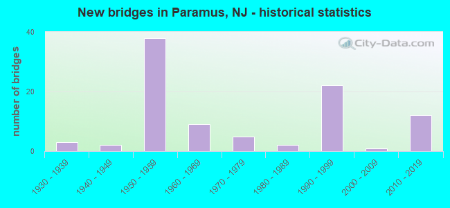
- New bridges - historical statistics
- 31930-1939
- 21940-1949
- 381950-1959
- 91960-1969
- 51970-1979
- 21980-1989
- 221990-1999
- 12000-2009
- 122010-2019
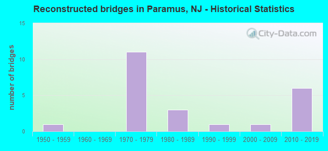
- Reconstructed bridges - Historical Statistics
- 11950-1959
- 01960-1969
- 111970-1979
- 31980-1989
- 11990-1999
- 12000-2009
- 62010-2019
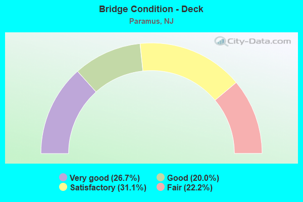
- Bridge Condition - Deck
- 26.7%Very good
- 20.0%Good
- 31.1%Satisfactory
- 22.2%Fair
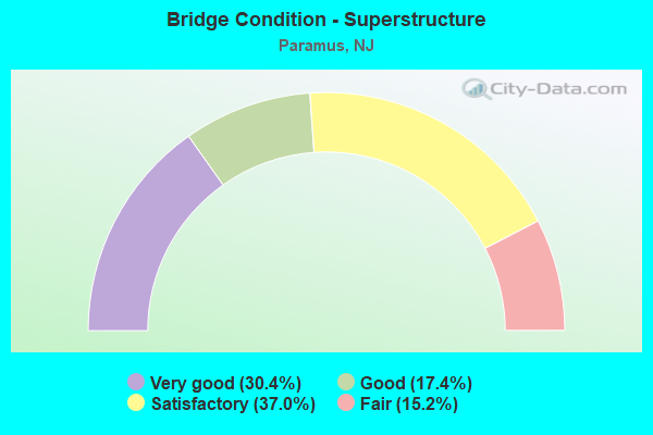
- Bridge Condition - Superstructure
- 30.4%Very good
- 17.4%Good
- 37.0%Satisfactory
- 15.2%Fair
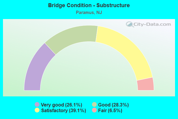
- Bridge Condition - Substructure
- 26.1%Very good
- 28.3%Good
- 39.1%Satisfactory
- 6.5%Fair
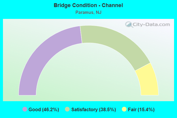
- Bridge Condition - Channel
- 46.2%Good
- 38.5%Satisfactory
- 15.4%Fair
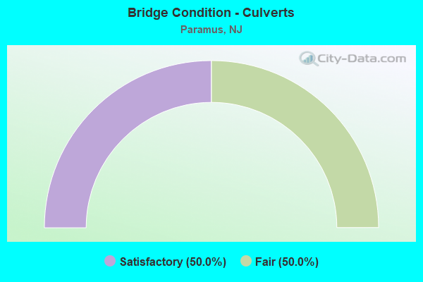
- Bridge Condition - Culverts
- 50.0%Satisfactory
- 50.0%Fair
Find on map >> Show street view
Structure Number: 361638S, Location: 0.7 MI N OF GSP&RT 17 JCT (Lat: 40.948117, Lng: -74.066767), Route carried "on" structure: Other road GSP, Year Built: 1956, Year Reconstructed: 1987, Status: Open, Structure Length: 3.44m (11.29ft), Average Daily Traffic: 51,583 (year 2020), Truck Traffic: 1%, Average Future Daily Traffic: 62,942 (year 2040), Design Load: HS 20, Features Intersected: E. MIDLAND AVENUE, Facility Carried by Structure: GARDEN ST PKWY SB
Minimum Vertical Clearance: 30+ m (98+ ft), Kilometerpoint: 263.755, Lanes on structure: 3, Lanes under structure: 4, Base Highway Network: Yes, Toll: On toll road, Owner: State Toll Authority, Approaching Roadway Width: 16.5m (54.1ft), Skew: 1 degrees, Material/Design: Prestressed concrete, Design/Construction: Stringer/Multi-beam, Number Of Spans In Main Unit: 3, Length of Maximum Span: 17.4m (57.1ft), Curb-To-Curb Width: 16.6m (54.5ft), Out-to-Out Width: 17.5m (57.4ft)
Condition: Deck: Satisfactory, Superstructure: Satisfactory, Substructure: Satisfactory, Operating Rating: 52.8 metric tons, Method Used To Determine Operating Rating: Load and Resistance Factor Rating (LRFR) rating reported by rating factor(RF) method using HL-93 loadings, Inventory Rating: 37.3 metric tons, Method Used To Determine Inventory Rating: Load and Resistance Factor Rating (LRFR) rating reported by rating factor(RF) method using HL-93 loadings, Structural Evaluation: Equal to present minimum criteria, Deck Geometry: Equal to present minimum criteria, Underclear: High priority of corrective action, Approach Roadway Alignment: Equal to present desirable criteria, Designated Inspection Frequency: Every 24 months, Inspection Date: April 2020, Deck Structure Type: Concrete Cast-file-Place, Wearing Surface/Protective System: Wearing Surface: Bituminous
Find on map >> Show street view
Structure Number: 361639N, Location: 0.7 MI N OF GSP&RT 17 JCT (Lat: 40.948153, Lng: -74.066381), Route carried "on" structure: Other road GSP, Year Built: 1956, Year Reconstructed: 1987, Status: Open, Structure Length: 4.11m (13.48ft), Average Daily Traffic: 55,291 (year 2020), Truck Traffic: 1%, Average Future Daily Traffic: 67,466 (year 2040), Design Load: H 20, Features Intersected: E. MIDLAND AVENUE, Facility Carried by Structure: GARDEN ST PKWY NB
Minimum Vertical Clearance: 30+ m (98+ ft), Kilometerpoint: 263.771, Lanes on structure: 3, Lanes under structure: 4, Base Highway Network: Yes, Toll: On toll road, Owner: State Toll Authority, Approaching Roadway Width: 17.4m (57.1ft), Skew: 1 degrees, Material/Design: Prestressed concrete, Design/Construction: Stringer/Multi-beam, Number Of Spans In Main Unit: 3, Length of Maximum Span: 20.4m (66.9ft), Curb-To-Curb Width: 16.6m (54.5ft), Out-to-Out Width: 17.5m (57.4ft)
Condition: Deck: Satisfactory, Superstructure: Satisfactory, Substructure: Satisfactory, Operating Rating: 34.7 metric tons, Method Used To Determine Operating Rating: Load and Resistance Factor Rating (LRFR) rating reported by rating factor(RF) method using HL-93 loadings, Inventory Rating: 25.3 metric tons, Method Used To Determine Inventory Rating: Load and Resistance Factor Rating (LRFR) rating reported by rating factor(RF) method using HL-93 loadings, Structural Evaluation: Equal to present minimum criteria, Deck Geometry: Equal to present minimum criteria, Underclear: High priority of corrective action, Approach Roadway Alignment: Equal to present desirable criteria, Designated Inspection Frequency: Every 24 months, Inspection Date: April 2020, Deck Structure Type: Concrete Cast-file-Place, Wearing Surface/Protective System: Wearing Surface: Bituminous
Find on map >> Show street view
Structure Number: 361640A, Location: .75 MI NE OF GSP&RT17 JCT (Lat: 40.951317, Lng: -74.066833), Route carried "on" structure: City street , Year Built: 1966, Status: Open, Structure Length: 1.37m (4.49ft), Average Daily Traffic: 2,308 (year 2020), Truck Traffic: 1%, Average Future Daily Traffic: 2,817 (year 2040), Design Load: HS 20, Features Intersected: SPROUT BROOK, Facility Carried by Structure: FROM ROAD
Minimum Vertical Clearance: 30+ m (98+ ft), Kilometerpoint: 0.000, Lanes on structure: 3, Owner: State Toll Authority, Approaching Roadway Width: 12.2m (40.0ft), Skew: 3 degrees, Material/Design: Prestressed concrete, Design/Construction: Box Beam or Girders - Multiple, Number Of Spans In Main Unit: 1, Length of Maximum Span: 11.9m (39.0ft), Curb or Sidewalk Widths: Left: 1.1m (3.6ft), Right: 0.5m (1.6ft), Curb-To-Curb Width: 12.3m (40.4ft), Out-to-Out Width: 14.6m (47.9ft)
Condition: Deck: Satisfactory, Superstructure: Satisfactory, Substructure: Satisfactory, Channel: Satisfactory, Operating Rating: 46.3 metric tons, Method Used To Determine Operating Rating: Load and Resistance Factor Rating (LRFR) rating reported by rating factor(RF) method using HL-93 loadings, Inventory Rating: 36.0 metric tons, Method Used To Determine Inventory Rating: Load and Resistance Factor Rating (LRFR) rating reported by rating factor(RF) method using HL-93 loadings, Structural Evaluation: Equal to present minimum criteria, Deck Geometry: Meets minimum limits, Waterway Adequacy: Better than present minimum criteria, Approach Roadway Alignment: Equal to present desirable criteria, Designated Inspection Frequency: Every 24 months, Inspection Date: May 2020, Deck Structure Type: Concrete Precast Panels, Wearing Surface/Protective System: Wearing Surface: Bituminous
Find on map >> Show street view
Structure Number: 361649T, Location: 1.75 MI N OF GSP&RT17 JCT (Lat: 40.963656, Lng: -74.065281), Route carried "on" structure: County highway 80, Year Built: 1965, Year Reconstructed: 1987, Status: Open, Structure Length: 12.22m (40.09ft), Average Daily Traffic: 28,301 (year 2020), Truck Traffic: 4%, Average Future Daily Traffic: 34,533 (year 2040), Design Load: HS 20, Features Intersected: GARDEN ST PARKWAY, Facility Carried by Structure: EAST RIDGEWOOD AVE
Minimum Vertical Clearance: 30+ m (98+ ft), Kilometerpoint: 7.387, Lanes on structure: 6, Lanes under structure: 9, Owner: State Toll Authority, Approaching Roadway Width: 23.2m (76.1ft), Skew: 22 degrees, Material/Design: Prestressed concrete, Design/Construction: Stringer/Multi-beam, Number Of Spans In Main Unit: 6, Length of Maximum Span: 22.6m (74.1ft), Curb or Sidewalk Widths: Left: 0.8m (2.6ft), Right: 1.6m (5.2ft), Curb-To-Curb Width: 21.6m (70.9ft), Out-to-Out Width: 26.3m (86.3ft)
Condition: Deck: Satisfactory, Superstructure: Satisfactory, Substructure: Satisfactory, Operating Rating: 35.3 metric tons, Method Used To Determine Operating Rating: Load and Resistance Factor Rating (LRFR) rating reported by rating factor(RF) method using HL-93 loadings, Inventory Rating: 25.3 metric tons, Method Used To Determine Inventory Rating: Load and Resistance Factor Rating (LRFR) rating reported by rating factor(RF) method using HL-93 loadings, Structural Evaluation: Equal to present minimum criteria, Deck Geometry: High priority of replacement, Underclear: High priority of corrective action, Approach Roadway Alignment: Equal to present desirable criteria, Designated Inspection Frequency: Every 24 months, Inspection Date: May 2020, Deck Structure Type: Concrete Cast-file-Place, Wearing Surface/Protective System: Wearing Surface: Bituminous
Find on map >> Show street view
Structure Number: 361659T, Location: 0.7MI S OF HILLSDALE TOLL (Lat: 40.976831, Lng: -74.070589), Route carried "on" structure: County highway 110, Year Built: 1987, Status: Open, Structure Length: 6.83m (22.41ft), Average Daily Traffic: 14,093 (year 2020), Truck Traffic: 4%, Average Future Daily Traffic: 17,197 (year 2040), Design Load: H 20, Features Intersected: GARDEN ST PARKWAY, Facility Carried by Structure: LINWOOD AVENUE
Minimum Vertical Clearance: 30+ m (98+ ft), Kilometerpoint: 3.685, Lanes on structure: 2, Lanes under structure: 8, Owner: State Toll Authority, Approaching Roadway Width: 13.7m (44.9ft), Skew: 2 degrees, Material/Design: Steel, Design/Construction: Stringer/Multi-beam, Number Of Spans In Main Unit: 4, Length of Maximum Span: 25.3m (83.0ft), Curb or Sidewalk Widths: Left: 1.8m (5.9ft), Right: 1.8m (5.9ft), Curb-To-Curb Width: 14.6m (47.9ft), Out-to-Out Width: 19.0m (62.3ft)
Condition: Deck: Satisfactory, Superstructure: Satisfactory, Substructure: Satisfactory, Operating Rating: 89.7 metric tons, Method Used To Determine Operating Rating: Load and Resistance Factor Rating (LRFR) rating reported by rating factor(RF) method using HL-93 loadings, Inventory Rating: 69.3 metric tons, Method Used To Determine Inventory Rating: Load and Resistance Factor Rating (LRFR) rating reported by rating factor(RF) method using HL-93 loadings, Structural Evaluation: Equal to present minimum criteria, Deck Geometry: Superior to present desirable criteria, Underclear: High priority of corrective action, Approach Roadway Alignment: Better than present minimum criteria, Designated Inspection Frequency: Every 24 months, Inspection Date: May 2020, Deck Structure Type: Concrete Cast-file-Place, Wearing Surface/Protective System: Wearing Surface: Monolithic Concrete, Deck Protection: Epoxy Coated Reinforcing
Find on map >> Show street view
Structure Number: 371630N, Location: AT GSP & RT 17 JUNCTION (Lat: 40.937317, Lng: -74.072139), Route carried "on" structure: Other road GSP, Year Built: 2016, Status: Open, Structure Length: 4.69m (15.39ft), Average Daily Traffic: 37,132 (year 2020), Truck Traffic: 1%, Average Future Daily Traffic: 45,309 (year 2040), Design Load: HL 93, Features Intersected: INT. 163 RAMP SBX, Facility Carried by Structure: GARDEN ST PKWY NB
Minimum Vertical Clearance: 30+ m (98+ ft), Kilometerpoint: 262.420, Lanes on structure: 3, Lanes under structure: 1, Base Highway Network: Yes, Toll: On toll road, Owner: State Toll Authority, Approaching Roadway Width: 20.1m (65.9ft), Skew: 1 degrees, Material/Design: Steel, Design/Construction: Stringer/Multi-beam, Number Of Spans In Main Unit: 1, Length of Maximum Span: 45.4m (149.0ft), Curb-To-Curb Width: 20.1m (65.9ft), Out-to-Out Width: 21.2m (69.6ft)
Condition: Deck: Very good, Superstructure: Very good, Substructure: Very good, Operating Rating: 61.9 metric tons, Method Used To Determine Operating Rating: Load and Resistance Factor Rating (LRFR) rating reported by rating factor(RF) method using HL-93 loadings, Inventory Rating: 48.0 metric tons, Method Used To Determine Inventory Rating: Load and Resistance Factor Rating (LRFR) rating reported by rating factor(RF) method using HL-93 loadings, Structural Evaluation: Equal to present desirable criteria, Deck Geometry: Superior to present desirable criteria, Underclear: Meets minimum limits, Approach Roadway Alignment: Equal to present desirable criteria, Designated Inspection Frequency: Every 24 months, Inspection Date: April 2020, Deck Structure Type: Concrete Cast-file-Place, Wearing Surface/Protective System: Wearing Surface: Monolithic Concrete, Deck Protection: Epoxy Coated Reinforcing
Find on map >> Show street view
Structure Number: 371631N, Location: AT GSP & RT 17 JUNCTION (Lat: 40.938511, Lng: -74.071497), Route carried "on" structure: Other road GSP, Year Built: 2016, Status: Open, Structure Length: 7.53m (24.70ft), Average Daily Traffic: 55,291 (year 2020), Truck Traffic: 1%, Average Future Daily Traffic: 67,466 (year 2040), Design Load: HL 93, Features Intersected: ROUTE NJ 17, Facility Carried by Structure: GARDEN ST PKWY NB
Minimum Vertical Clearance: 30+ m (98+ ft), Kilometerpoint: 262.564, Lanes on structure: 3, Lanes under structure: 6, Base Highway Network: Yes, Toll: On toll road, Owner: State Toll Authority, Approaching Roadway Width: 18.3m (60.0ft), Skew: 5 degrees, Material/Design: Steel, Design/Construction: Stringer/Multi-beam, Number Of Spans In Main Unit: 1, Length of Maximum Span: 71.6m (234.9ft), Curb-To-Curb Width: 18.3m (60.0ft), Out-to-Out Width: 19.4m (63.6ft)
Condition: Deck: Very good, Superstructure: Very good, Substructure: Very good, Operating Rating: 69.0 metric tons, Method Used To Determine Operating Rating: Load and Resistance Factor Rating (LRFR) rating reported by rating factor(RF) method using HL-93 loadings, Inventory Rating: 53.5 metric tons, Method Used To Determine Inventory Rating: Load and Resistance Factor Rating (LRFR) rating reported by rating factor(RF) method using HL-93 loadings, Structural Evaluation: Equal to present desirable criteria, Deck Geometry: Better than present minimum criteria, Underclear: High priority of corrective action, Approach Roadway Alignment: Equal to present desirable criteria, Designated Inspection Frequency: Every 24 months, Inspection Date: April 2020, Deck Structure Type: Concrete Cast-file-Place, Wearing Surface/Protective System: Wearing Surface: Monolithic Concrete, Deck Protection: Epoxy Coated Reinforcing
Find on map >> Show street view
Structure Number: 371632S, Location: AT GSP & RT 17 JUNCTION (Lat: 40.939139, Lng: -74.071525), Route carried "on" structure: Other road GSP, Year Built: 2016, Status: Open, Structure Length: 7.41m (24.31ft), Average Daily Traffic: 51,582 (year 2020), Truck Traffic: 1%, Average Future Daily Traffic: 62,940 (year 2040), Design Load: HL 93, Features Intersected: ROUTE NJ 17, Facility Carried by Structure: GARDEN ST PKWY SB
Minimum Vertical Clearance: 30+ m (98+ ft), Kilometerpoint: 262.564, Lanes on structure: 3, Lanes under structure: 6, Base Highway Network: Yes, Toll: On toll road, Owner: State Toll Authority, Approaching Roadway Width: 17.7m (58.1ft), Skew: 5 degrees, Material/Design: Steel, Design/Construction: Stringer/Multi-beam, Number Of Spans In Main Unit: 1, Length of Maximum Span: 70.7m (232.0ft), Curb-To-Curb Width: 17.7m (58.1ft), Out-to-Out Width: 18.8m (61.7ft)
Condition: Deck: Very good, Superstructure: Very good, Substructure: Very good, Operating Rating: 72.3 metric tons, Method Used To Determine Operating Rating: Load and Resistance Factor Rating (LRFR) rating reported by rating factor(RF) method using HL-93 loadings, Inventory Rating: 55.7 metric tons, Method Used To Determine Inventory Rating: Load and Resistance Factor Rating (LRFR) rating reported by rating factor(RF) method using HL-93 loadings, Structural Evaluation: Equal to present desirable criteria, Deck Geometry: Better than present minimum criteria, Underclear: High priority of corrective action, Approach Roadway Alignment: Equal to present desirable criteria, Designated Inspection Frequency: Every 24 months, Inspection Date: April 2020, Deck Structure Type: Concrete Cast-file-Place, Wearing Surface/Protective System: Wearing Surface: Monolithic Concrete, Deck Protection: Epoxy Coated Reinforcing
Find on map >> Show street view
Structure Number: 371633S, Location: AT GSP & RT 17 JUNCTION (Lat: 40.940197, Lng: -74.070481), Route carried "on" structure: Other road GSP, Year Built: 2016, Status: Open, Structure Length: 3.99m (13.09ft), Average Daily Traffic: 51,582 (year 2020), Truck Traffic: 1%, Average Future Daily Traffic: 62,940 (year 2040), Design Load: HL 93, Features Intersected: INT 163 RAMP NBX, Facility Carried by Structure: GARDEN ST PKWY SB
Minimum Vertical Clearance: 30+ m (98+ ft), Kilometerpoint: 262.790, Lanes on structure: 3, Lanes under structure: 1, Base Highway Network: Yes, Toll: On toll road, Owner: State Toll Authority, Approaching Roadway Width: 17.7m (58.1ft), Skew: 3 degrees, Material/Design: Steel, Design/Construction: Stringer/Multi-beam, Number Of Spans In Main Unit: 1, Length of Maximum Span: 38.1m (125.0ft), Curb-To-Curb Width: 17.7m (58.1ft), Out-to-Out Width: 18.8m (61.7ft)
Condition: Deck: Very good, Superstructure: Very good, Substructure: Very good, Operating Rating: 66.7 metric tons, Method Used To Determine Operating Rating: Load and Resistance Factor Rating (LRFR) rating reported by rating factor(RF) method using HL-93 loadings, Inventory Rating: 51.5 metric tons, Method Used To Determine Inventory Rating: Load and Resistance Factor Rating (LRFR) rating reported by rating factor(RF) method using HL-93 loadings, Structural Evaluation: Equal to present desirable criteria, Deck Geometry: Better than present minimum criteria, Underclear: Meets minimum limits, Approach Roadway Alignment: Equal to present desirable criteria, Designated Inspection Frequency: Every 24 months, Inspection Date: April 2020, Deck Structure Type: Concrete Cast-file-Place, Wearing Surface/Protective System: Wearing Surface: Monolithic Concrete, Deck Protection: Epoxy Coated Reinforcing
Find on map >> Show street view
Structure Number: 206152, Location: 0.2 MI EAST OF SADDLE RIV (Lat: 40.925611, Lng: -74.089461), Route carried "under" structure: State highway 4, Year Built: 1956, Structure Length: 0. m, Average Daily Traffic: 103,112 (year 2020), Truck Traffic: 5%, Features Intersected: NJ 4, Facility Carried by Structure: PARAMUS RD (CR 62)
Minimum Vertical Clearance: 4.95m (16.24ft), Kilometerpoint: 3.830, Lanes on structure: 4, Lanes under structure: 9, Material/Design: Steel, Design/Construction: Stringer/Multi-beam, Length of Maximum Span: 24.7m (81.0ft)
Find on map >> Show street view
Structure Number: 206154, Location: 0.2 MI EAST OF RT 17 (Lat: 40.919700, Lng: -74.068781), Route carried "under" structure: State highway 4, Year Built: 1999, Structure Length: 0. m, Average Daily Traffic: 136,121 (year 2020), Truck Traffic: 5%, Features Intersected: NJ 4, Facility Carried by Structure: FARVIEW AVE(CR 61)
Minimum Vertical Clearance: 5.16m (16.93ft), Kilometerpoint: 5.697, Lanes on structure: 3, Lanes under structure: 9, Material/Design: Steel continuous, Design/Construction: Stringer/Multi-beam, Length of Maximum Span: 21.6m (70.9ft)
Find on map >> Show street view
Structure Number: 206155, Location: 0.5 MI. EAST OF NJ 17 (Lat: 40.917811, Lng: -74.061411), Route carried "under" structure: State highway 4, Year Built: 1958, Structure Length: 0. m, Average Daily Traffic: 136,121 (year 2020), Truck Traffic: 4%, Features Intersected: NJ 4, Facility Carried by Structure: SPRING VALLEY RD
Minimum Vertical Clearance: 4.44m (14.57ft), Kilometerpoint: 6.260, Lanes on structure: 2, Lanes under structure: 7, Material/Design: Steel, Design/Construction: Stringer/Multi-beam, Length of Maximum Span: 28.7m (94.2ft)
Find on map >> Show street view
Structure Number: 206159, Location: 1.0 MI EAST NJ 17 (Lat: 40.915919, Lng: -74.054819), Route carried "under" structure: State highway 4, Year Built: 1937, Structure Length: 0. m, Average Daily Traffic: 165,499 (year 2020), Truck Traffic: 5%, Features Intersected: NJ 4, Facility Carried by Structure: FOREST AVE (CR 59)
Minimum Vertical Clearance: 4.29m (14.07ft), Kilometerpoint: 6.936, Lanes on structure: 4, Lanes under structure: 7, Material/Design: Steel, Design/Construction: Stringer/Multi-beam, Length of Maximum Span: 15.8m (51.8ft)
Find on map >> Show street view
Structure Number: 20619, Location: 0.04 MI E OF NJ4&NJ17 JCT (Lat: 40.919569, Lng: -74.072069), Route carried "under" structure: State highway 17, Year Built: 1999, Structure Length: 0. m, Average Daily Traffic: 118,041 (year 2021), Truck Traffic: 5%, Features Intersected: NJ 4, NJ 17 & RAMP, Facility Carried by Structure: NJ 4 RAMP NW
Minimum Vertical Clearance: 5.59m (18.34ft), Kilometerpoint: 19.843, Lanes on structure: 1, Lanes under structure: 8, Material/Design: Steel continuous, Design/Construction: Stringer/Multi-beam, Length of Maximum Span: 51.2m (168.0ft)
Find on map >> Show street view
Structure Number: 20619, Location: 0.04 MI E OF NJ4&NJ17 JCT (Lat: 40.919569, Lng: -74.072069), Route carried "under" structure: State highway 4, Year Built: 1999, Structure Length: 0. m, Average Daily Traffic: 121,743 (year 2021), Truck Traffic: 5%, Features Intersected: NJ 4, NJ 17 & RAMP
Minimum Vertical Clearance: 6.71m (22.01ft), Kilometerpoint: 5.375, Lanes on structure: 1, Lanes under structure: 4, Material/Design: Steel continuous, Design/Construction: Stringer/Multi-beam, Length of Maximum Span: 51.2m (168.0ft)
Find on map >> Show street view
Structure Number: 20619, Location: 0.04 MI E OF NJ4&NJ17 JCT (Lat: 40.919569, Lng: -74.072069), Route carried "under" structure: Ramp State highway 4, Year Built: 1999, Structure Length: 0. m, Average Daily Traffic: 20,408 (year 2021), Truck Traffic: 5%, Features Intersected: NJ 4, NJ 17 & RAMP
Minimum Vertical Clearance: 7.62m (25.00ft), Kilometerpoint: 5.375, Lanes on structure: 1, Lanes under structure: 2, Material/Design: Steel continuous, Design/Construction: Stringer/Multi-beam, Length of Maximum Span: 51.2m (168.0ft)
Find on map >> Show street view
Structure Number: 206192, Location: 0.15 MI EAST OF GSP (Lat: 40.921800, Lng: -74.077731), Route carried "under" structure: State highway 4, Year Built: 1999, Structure Length: 0. m, Average Daily Traffic: 117,756 (year 2020), Truck Traffic: 5%, Features Intersected: NJ 4 & C-D RAMPS, Facility Carried by Structure: IKEA DRIVE
Minimum Vertical Clearance: 5.82m (19.09ft), Kilometerpoint: 4.908, Lanes on structure: 4, Lanes under structure: 5, Material/Design: Steel continuous, Design/Construction: Stringer/Multi-beam, Length of Maximum Span: 39.3m (128.9ft)
Find on map >> Show street view
Structure Number: 206192, Location: 0.15 MI EAST OF GSP (Lat: 40.921800, Lng: -74.077731), Route carried "under" structure: Ramp State highway 4, Year Built: 1999, Structure Length: 0. m, Average Daily Traffic: 21,755 (year 2020), Truck Traffic: 5%, Features Intersected: NJ 4 & C-D RAMPS, Facility Carried by Structure: IKEA DRIVE
Minimum Vertical Clearance: 5.82m (19.09ft), Kilometerpoint: 4.908, Lanes on structure: 4, Lanes under structure: 3, Material/Design: Steel continuous, Design/Construction: Stringer/Multi-beam, Length of Maximum Span: 39.3m (128.9ft)
Find on map >> Show street view
Structure Number: 206192, Location: 0.15 MI EAST OF GSP (Lat: 40.921800, Lng: -74.077731), Route carried "under" structure: Ramp State highway 4, Year Built: 1999, Structure Length: 0. m, Average Daily Traffic: 21,755 (year 2020), Truck Traffic: 5%, Features Intersected: NJ 4 & C-D RAMPS, Facility Carried by Structure: IKEA DRIVE
Minimum Vertical Clearance: 5.43m (17.81ft), Kilometerpoint: 4.908, Lanes on structure: 4, Lanes under structure: 3, Material/Design: Steel continuous, Design/Construction: Stringer/Multi-beam, Length of Maximum Span: 39.3m (128.9ft)
Find on map >> Show street view
Structure Number: 206193, Location: ROUTES 4 AND 17 INTERCHNG (Lat: 40.922139, Lng: -74.072861), Route carried "under" structure: Ramp State highway 4, Year Built: 1999, Structure Length: 0. m, Average Daily Traffic: 78,720 (year 2020), Truck Traffic: 5%, Features Intersected: NJ RT.4,RT 17 AND RAMPS
Minimum Vertical Clearance: 12.04m (39.50ft), Kilometerpoint: 5.375, Lanes on structure: 1, Lanes under structure: 3, Material/Design: Steel continuous, Design/Construction: Stringer/Multi-beam, Length of Maximum Span: 42.7m (140.1ft)
Find on map >> Show street view
Structure Number: 206193, Location: ROUTES 4 AND 17 INTERCHNG (Lat: 40.922139, Lng: -74.072861), Route carried "under" structure: Ramp State highway 4, Year Built: 1999, Structure Length: 0. m, Average Daily Traffic: 6,460 (year 2020), Truck Traffic: 5%, Features Intersected: NJ RT.4,RT 17 AND RAMPS
Minimum Vertical Clearance: 5.97m (19.59ft), Kilometerpoint: 5.375, Lanes on structure: 1, Lanes under structure: 1, Material/Design: Steel continuous, Design/Construction: Stringer/Multi-beam, Length of Maximum Span: 42.7m (140.1ft)
Find on map >> Show street view
Structure Number: 206193, Location: ROUTES 4 AND 17 INTERCHNG (Lat: 40.922139, Lng: -74.072861), Route carried "under" structure: State highway 4, Year Built: 1999, Structure Length: 0. m, Average Daily Traffic: 157,430 (year 2020), Truck Traffic: 5%, Features Intersected: NJ RT.4,RT 17 AND RAMPS
Minimum Vertical Clearance: 10.21m (33.50ft), Kilometerpoint: 5.375, Lanes on structure: 1, Lanes under structure: 4, Material/Design: Steel continuous, Design/Construction: Stringer/Multi-beam, Length of Maximum Span: 42.7m (140.1ft)
Find on map >> Show street view
Structure Number: 206193, Location: ROUTES 4 AND 17 INTERCHNG (Lat: 40.922139, Lng: -74.072861), Route carried "under" structure: State highway 4, Year Built: 1999, Structure Length: 0. m, Average Daily Traffic: 6,460 (year 2020), Truck Traffic: 5%, Features Intersected: NJ RT.4,RT 17 AND RAMPS
Minimum Vertical Clearance: 7.62m (25.00ft), Kilometerpoint: 5.375, Lanes on structure: 1, Lanes under structure: 1, Material/Design: Steel continuous, Design/Construction: Stringer/Multi-beam, Length of Maximum Span: 42.7m (140.1ft)
Find on map >> Show street view
Structure Number: 206193, Location: ROUTES 4 AND 17 INTERCHNG (Lat: 40.922139, Lng: -74.072861), Route carried "under" structure: State highway 17, Year Built: 1999, Structure Length: 0. m, Average Daily Traffic: 161,700 (year 2020), Truck Traffic: 5%, Features Intersected: NJ RT.4,RT 17 AND RAMPS, Facility Carried by Structure: NJ RTE 4 RAMP SE
Minimum Vertical Clearance: 5.23m (17.16ft), Kilometerpoint: 19.843, Lanes on structure: 1, Lanes under structure: 8, Material/Design: Steel continuous, Design/Construction: Stringer/Multi-beam, Length of Maximum Span: 42.7m (140.1ft)
Find on map >> Show street view
Structure Number: 206193, Location: ROUTES 4 AND 17 INTERCHNG (Lat: 40.922139, Lng: -74.072861), Route carried "under" structure: Ramp State highway 4, Year Built: 1999, Structure Length: 0. m, Average Daily Traffic: 77,170 (year 2020), Truck Traffic: 5%, Features Intersected: NJ RT.4,RT 17 AND RAMPS
Minimum Vertical Clearance: 12.93m (42.42ft), Kilometerpoint: 5.375, Lanes on structure: 1, Lanes under structure: 2, Material/Design: Steel continuous, Design/Construction: Stringer/Multi-beam, Length of Maximum Span: 42.7m (140.1ft)
Find on map >> Show street view
Structure Number: 214162, Location: 0.5 MILES SOUTH OF NJ 4 (Lat: 40.912950, Lng: -74.071600), Route carried "under" structure: State highway 17, Year Built: 1994, Structure Length: 0. m, Average Daily Traffic: 116,839 (year 2020), Truck Traffic: 4%, Features Intersected: NJ 17, Facility Carried by Structure: FARVIEW AV (CR 61)
Minimum Vertical Clearance: 5.03m (16.50ft), Kilometerpoint: 19.022, Lanes on structure: 4, Lanes under structure: 5, Material/Design: Steel continuous, Design/Construction: Stringer/Multi-beam, Length of Maximum Span: 37.5m (123.0ft)
Find on map >> Show street view
Structure Number: 21515, Location: INTERSECTION RT 4 (Lat: 40.920500, Lng: -74.072119), Route carried "under" structure: State highway 4, Year Built: 1999, Structure Length: 0. m, Average Daily Traffic: 139,130 (year 2022), Truck Traffic: 4%, Features Intersected: ROUTE NJ 4, Facility Carried by Structure: ROUTE NJ 17
Minimum Vertical Clearance: 5.27m (17.29ft), Kilometerpoint: 5.375, Lanes on structure: 8, Lanes under structure: 9, Material/Design: Steel continuous, Design/Construction: Stringer/Multi-beam, Length of Maximum Span: 34.1m (111.9ft)
Find on map >> Show street view
Structure Number: 215151, Location: 0.55 MILE NORTH O F NJ 4 (Lat: 40.928469, Lng: -74.070839), Route carried "under" structure: State highway 17, Year Built: 1959, Structure Length: 0. m, Average Daily Traffic: 141,498 (year 2020), Truck Traffic: 5%, Features Intersected: NJ 17, Facility Carried by Structure: CENTURY ROAD
Minimum Vertical Clearance: 4.67m (15.32ft), Kilometerpoint: 20.728, Lanes on structure: 3, Lanes under structure: 8, Material/Design: Steel, Design/Construction: Stringer/Multi-beam, Length of Maximum Span: 19.5m (64.0ft)
Find on map >> Show street view
Structure Number: 216152, Location: 0.67 MI NORTH OF GSP (Lat: 40.949600, Lng: -74.072481), Route carried "under" structure: State highway 17, Year Built: 1959, Structure Length: 0. m, Average Daily Traffic: 156,224 (year 2020), Truck Traffic: 5%, Features Intersected: NJ 17, Facility Carried by Structure: MIDLAND AVENUE
Minimum Vertical Clearance: 4.47m (14.67ft), Kilometerpoint: 23.207, Lanes on structure: 3, Lanes under structure: 8, Material/Design: Steel, Design/Construction: Stringer/Multi-beam, Length of Maximum Span: 26.2m (86.0ft)
Find on map >> Show street view
Structure Number: 216155, Location: 3.4 MI NORTH OF NJ 4 (Lat: 40.969969, Lng: -74.079819), Route carried "under" structure: State highway 17, Year Built: 1961, Structure Length: 0. m, Average Daily Traffic: 157,062 (year 2020), Truck Traffic: 5%, Features Intersected: NJ 17, Facility Carried by Structure: RIDGEWOOD AVENUE
Minimum Vertical Clearance: 5.03m (16.50ft), Kilometerpoint: 25.299, Lanes on structure: 4, Lanes under structure: 8, Material/Design: Steel continuous, Design/Construction: Stringer/Multi-beam, Length of Maximum Span: 26.2m (86.0ft)
Find on map >> Show street view
Structure Number: 216411, Location: 5.0 MI N OF RT 80 & 17JCT (Lat: 40.960139, Lng: -74.076500), Route carried "under" structure: State highway 17, Year Built: 1972, Structure Length: 0. m, Average Daily Traffic: 140,650 (year 2021), Truck Traffic: 4%, Features Intersected: N.J. ROUTE 17, Facility Carried by Structure: PARAMUS PK ACCESS
Minimum Vertical Clearance: 5.32m (17.45ft), Kilometerpoint: 24.269, Lanes on structure: 2, Lanes under structure: 6, Material/Design: Steel, Design/Construction: Stringer/Multi-beam, Length of Maximum Span: 37.5m (123.0ft)
Find on map >> Show street view
Structure Number: 361615N, Location: 0.5 MI SW OF GSP&RT4 JCT (Lat: 40.920161, Lng: -74.085631), Route carried "under" structure: County highway 62, Year Built: 1956, Structure Length: 0. m, Average Daily Traffic: 15,602 (year 2020), Truck Traffic: 4%, Features Intersected: PARAMUS RD (CR 62), Facility Carried by Structure: Parkway N
Minimum Vertical Clearance: 4.52m (14.83ft), Kilometerpoint: 5.246, Lanes on structure: 3, Lanes under structure: 6, Material/Design: Steel, Design/Construction: Stringer/Multi-beam, Length of Maximum Span: 21.3m (69.9ft)
Find on map >> Show street view
Structure Number: 361615S, Location: 0.5 MI SW OF GSP&RT4 JCT (Lat: 40.920300, Lng: -74.085700), Route carried "under" structure: County highway 62, Year Built: 1956, Structure Length: 0. m, Average Daily Traffic: 15,602 (year 2020), Truck Traffic: 4%, Features Intersected: PARAMUS ROAD (CR 62), Facility Carried by Structure: GARDEN ST PKWY SB
Minimum Vertical Clearance: 4.60m (15.09ft), Kilometerpoint: 5.246, Lanes on structure: 3, Lanes under structure: 6, Material/Design: Steel, Design/Construction: Stringer/Multi-beam, Length of Maximum Span: 21.3m (69.9ft)
Find on map >> Show street view
Structure Number: 361616S, Location: 0.3 MI SW OF GSP&RT4 JCT (Lat: 40.921497, Lng: -74.083208), Route carried "under" structure: City street , Year Built: 1954, Structure Length: 0. m, Average Daily Traffic: 125 (year 2020), Truck Traffic: 1%, Features Intersected: BRIDLE WAY, Facility Carried by Structure: Parkway S
Minimum Vertical Clearance: 4.44m (14.57ft), Kilometerpoint: 0.000, Lanes on structure: 3, Lanes under structure: 2, Material/Design: Steel, Design/Construction: Stringer/Multi-beam, Length of Maximum Span: 15.8m (51.8ft)
Find on map >> Show street view
Structure Number: 361617N, Location: 0.3 MI SW OF GSP&RT4 JCT (Lat: 40.921406, Lng: -74.082997), Route carried "under" structure: City street , Year Built: 1954, Structure Length: 0. m, Average Daily Traffic: 124 (year 2020), Truck Traffic: 1%, Features Intersected: BRIDLE WAY, Facility Carried by Structure: Parkway N
Minimum Vertical Clearance: 4.70m (15.42ft), Kilometerpoint: 0.000, Lanes on structure: 4, Lanes under structure: 2, Material/Design: Steel, Design/Construction: Stringer/Multi-beam, Length of Maximum Span: 15.8m (51.8ft)
Find on map >> Show street view
Structure Number: 361618S, Location: AT GSP & RT 4 JUNCTION (Lat: 40.922769, Lng: -74.080139), Route carried "under" structure: State highway 4, Year Built: 1954, Structure Length: 0. m, Average Daily Traffic: 131,389 (year 2020), Truck Traffic: 4%, Features Intersected: ROUTE NJ 4, Facility Carried by Structure: GARDEN ST PKWY SB
Minimum Vertical Clearance: 4.98m (16.34ft), Kilometerpoint: 4.667, Lanes on structure: 4, Lanes under structure: 9, Material/Design: Steel, Design/Construction: Stringer/Multi-beam, Length of Maximum Span: 31.4m (103.0ft)
Find on map >> Show street view
Structure Number: 361619N, Location: AT GSP & RT 4 JUNCTION (Lat: 40.922711, Lng: -74.079939), Route carried "under" structure: State highway 4, Year Built: 1954, Structure Length: 0. m, Average Daily Traffic: 131,377 (year 2020), Truck Traffic: 4%, Features Intersected: ROUTE NJ 4, Facility Carried by Structure: GARDEN ST PKWY NB
Minimum Vertical Clearance: 5.08m (16.67ft), Kilometerpoint: 4.667, Lanes on structure: 3, Lanes under structure: 9, Material/Design: Steel, Design/Construction: Stringer/Multi-beam, Length of Maximum Span: 33.8m (110.9ft)
Find on map >> Show street view
Structure Number: 361624S, Location: 0.5 MI S OF GSP&RT17 JCT (Lat: 40.929922, Lng: -74.072461), Route carried "under" structure: City street , Year Built: 1956, Structure Length: 0. m, Average Daily Traffic: 3,185 (year 2020), Truck Traffic: 1%, Features Intersected: WEST CENTURY ROAD, Facility Carried by Structure: Parkway S
Minimum Vertical Clearance: 5.11m (16.77ft), Kilometerpoint: 2.124, Lanes on structure: 3, Lanes under structure: 2, Material/Design: Steel, Design/Construction: Stringer/Multi-beam, Length of Maximum Span: 15.2m (49.9ft)
Find on map >> Show street view
Structure Number: 361625N, Location: 0.5 MI S OF GSP&RT17 JCT (Lat: 40.929878, Lng: -74.072297), Route carried "under" structure: City street , Year Built: 1956, Structure Length: 0. m, Average Daily Traffic: 3,185 (year 2020), Truck Traffic: 1%, Features Intersected: WEST CENTURY ROAD, Facility Carried by Structure: Parkway N
Minimum Vertical Clearance: 4.78m (15.68ft), Kilometerpoint: 2.124, Lanes on structure: 3, Lanes under structure: 2, Material/Design: Steel, Design/Construction: Stringer/Multi-beam, Length of Maximum Span: 15.2m (49.9ft)
Find on map >> Show street view
Structure Number: 361630D, Location: AT GSP & RT 17 JUNCTION (Lat: 40.937036, Lng: -74.072042), Route carried "under" structure: Ramp Other road GSP, Year Built: 1956, Structure Length: 0. m, Average Daily Traffic: 15,302 (year 2020), Truck Traffic: 1%, Features Intersected: GSP INT. 163 RAMP SBX, Facility Carried by Structure: INT. 163 RAMP NBX
Minimum Vertical Clearance: 4.78m (15.68ft), Kilometerpoint: 262.420, Lanes on structure: 1, Lanes under structure: 1, Toll: On toll road, Material/Design: Steel continuous, Design/Construction: Stringer/Multi-beam, Length of Maximum Span: 13.4m (44.0ft)
Find on map >> Show street view
Structure Number: 361630S, Location: AT GSP & RT 17 JUNCTION (Lat: 40.937583, Lng: -74.072300), Route carried "under" structure: Ramp Other road GSP, Year Built: 2016, Structure Length: 0. m, Average Daily Traffic: 15,302 (year 2020), Truck Traffic: 1%, Features Intersected: INT. 163 RAMP SBX, Facility Carried by Structure: GARDEN ST PKWY SB
Minimum Vertical Clearance: 4.62m (15.16ft), Kilometerpoint: 262.420, Lanes on structure: 3, Lanes under structure: 1, Toll: On toll road, Material/Design: Steel continuous, Design/Construction: Stringer/Multi-beam, Length of Maximum Span: 43.3m (142.1ft)
Find on map >> Show street view
Structure Number: 361631B, Location: AT GSP & RT 17 JUNCTION (Lat: 40.939403, Lng: -74.071544), Route carried "under" structure: State highway 17, Year Built: 1956, Structure Length: 0. m, Average Daily Traffic: 153,177 (year 2020), Truck Traffic: 5%, Features Intersected: ROUTE NJ 17, Facility Carried by Structure: INT. 163 RAMP SBX
Minimum Vertical Clearance: 5.13m (16.83ft), Kilometerpoint: 21.984, Lanes on structure: 1, Lanes under structure: 6, Material/Design: Steel continuous, Design/Construction: Stringer/Multi-beam, Length of Maximum Span: 32.0m (105.0ft)
Find on map >> Show street view
Structure Number: 361631D, Location: AT GSP & RT 17 JUNCTION (Lat: 40.938453, Lng: -74.071456), Route carried "under" structure: State highway 17, Year Built: 1956, Structure Length: 0. m, Average Daily Traffic: 156,178 (year 2020), Truck Traffic: 5%, Features Intersected: ROUTE NJ 17, Facility Carried by Structure: INT. 163 RAMP NBX
Minimum Vertical Clearance: 5.05m (16.57ft), Kilometerpoint: 21.871, Lanes on structure: 1, Lanes under structure: 6, Material/Design: Steel continuous, Design/Construction: Stringer/Multi-beam, Length of Maximum Span: 36.3m (119.1ft)
Find on map >> Show street view
Structure Number: 361632B, Location: AT GSP & RT 17 JUNCTION (Lat: 40.940594, Lng: -74.070564), Route carried "under" structure: Ramp Other road GSP, Year Built: 1956, Structure Length: 0. m, Average Daily Traffic: 15,302 (year 2020), Truck Traffic: 1%, Features Intersected: GSP INT. 163 RAMP NBX, Facility Carried by Structure: INT. 163 RAMP SBX
Minimum Vertical Clearance: 4.80m (15.75ft), Kilometerpoint: 262.790, Lanes on structure: 1, Lanes under structure: 1, Toll: On toll road, Material/Design: Steel, Design/Construction: Stringer/Multi-beam, Length of Maximum Span: 12.8m (42.0ft)
Find on map >> Show street view
Structure Number: 361632N, Location: AT GSP & RT 17 JUNCTION (Lat: 40.939756, Lng: -74.070567), Route carried "under" structure: Ramp Other road GSP, Year Built: 2016, Structure Length: 0. m, Average Daily Traffic: 15,302 (year 2020), Truck Traffic: 1%, Features Intersected: INT 163 RAMP NBX, Facility Carried by Structure: GARDEN ST PKWY NB
Minimum Vertical Clearance: 4.72m (15.49ft), Kilometerpoint: 262.790, Lanes on structure: 3, Lanes under structure: 1, Toll: On toll road, Material/Design: Steel continuous, Design/Construction: Stringer/Multi-beam, Length of Maximum Span: 34.4m (112.9ft)
Find on map >> Show street view
Structure Number: 361638S, Location: 0.7 MI N OF GSP&RT 17 JCT (Lat: 40.948117, Lng: -74.066767), Route carried "under" structure: City street , Year Built: 1956, Structure Length: 0. m, Average Daily Traffic: 9,604 (year 2020), Truck Traffic: 4%, Features Intersected: E. MIDLAND AVENUE, Facility Carried by Structure: GARDEN ST PKWY SB
Minimum Vertical Clearance: 4.44m (14.57ft), Kilometerpoint: 4.764, Lanes on structure: 3, Lanes under structure: 4, Material/Design: Prestressed concrete, Design/Construction: Stringer/Multi-beam, Length of Maximum Span: 17.4m (57.1ft)
Find on map >> Show street view
Structure Number: 361639N, Location: 0.7 MI N OF GSP&RT 17 JCT (Lat: 40.948153, Lng: -74.066381), Route carried "under" structure: City street , Year Built: 1956, Structure Length: 0. m, Average Daily Traffic: 9,604 (year 2020), Truck Traffic: 4%, Features Intersected: E. MIDLAND AVENUE, Facility Carried by Structure: GARDEN ST PKWY NB
Minimum Vertical Clearance: 4.40m (14.44ft), Kilometerpoint: 4.764, Lanes on structure: 3, Lanes under structure: 4, Material/Design: Prestressed concrete, Design/Construction: Stringer/Multi-beam, Length of Maximum Span: 20.4m (66.9ft)
Find on map >> Show street view
Structure Number: 361649T, Location: 1.75 MI N OF GSP&RT17 JCT (Lat: 40.963656, Lng: -74.065281), Route carried "under" structure: Other road GSP, Year Built: 1965, Structure Length: 0. m, Average Daily Traffic: 75,891 (year 2020), Truck Traffic: 1%, Features Intersected: GARDEN ST PARKWAY, Facility Carried by Structure: EAST RIDGEWOOD AVE
Minimum Vertical Clearance: 4.50m (14.76ft), Kilometerpoint: 265.381, Lanes on structure: 6, Lanes under structure: 6, Toll: On toll road, Material/Design: Prestressed concrete, Design/Construction: Stringer/Multi-beam, Length of Maximum Span: 22.6m (74.1ft)
Find on map >> Show street view
Structure Number: 361649T, Location: 1.75 MI N OF GSP&RT17 JCT (Lat: 40.963656, Lng: -74.065281), Route carried "under" structure: Ramp Other road GSP, Year Built: 1965, Structure Length: 0. m, Average Daily Traffic: 7,896 (year 2020), Truck Traffic: 1%, Features Intersected: GARDEN ST PARKWAY, Facility Carried by Structure: EAST RIDGEWOOD AVE
Minimum Vertical Clearance: 4.55m (14.93ft), Kilometerpoint: 265.381, Lanes on structure: 6, Lanes under structure: 2, Toll: On toll road, Material/Design: Prestressed concrete, Design/Construction: Stringer/Multi-beam, Length of Maximum Span: 22.6m (74.1ft)
Find on map >> Show street view
Structure Number: 361649T, Location: 1.75 MI N OF GSP&RT17 JCT (Lat: 40.963656, Lng: -74.065281), Route carried "under" structure: Ramp Other road GSP, Year Built: 1965, Structure Length: 0. m, Average Daily Traffic: 7,896 (year 2020), Truck Traffic: 1%, Features Intersected: GARDEN ST PARKWAY, Facility Carried by Structure: EAST RIDGEWOOD AVE
Minimum Vertical Clearance: 4.98m (16.34ft), Kilometerpoint: 265.381, Lanes on structure: 6, Lanes under structure: 1, Toll: On toll road, Material/Design: Prestressed concrete, Design/Construction: Stringer/Multi-beam, Length of Maximum Span: 22.6m (74.1ft)
Find on map >> Show street view
Structure Number: 361659T, Location: 0.7MI S OF HILLSDALE TOLL (Lat: 40.976831, Lng: -74.070589), Route carried "under" structure: Other road GSP, Year Built: 1987, Structure Length: 0. m, Average Daily Traffic: 89,467 (year 2020), Truck Traffic: 1%, Features Intersected: GARDEN ST PARKWAY, Facility Carried by Structure: LINWOOD AVENUE
Minimum Vertical Clearance: 4.70m (15.42ft), Kilometerpoint: 267.038, Lanes on structure: 2, Lanes under structure: 8, Toll: On toll road, Material/Design: Steel, Design/Construction: Stringer/Multi-beam, Length of Maximum Span: 25.3m (83.0ft)
Find on map >> Show street view
Structure Number: 371630N, Location: AT GSP & RT 17 JUNCTION (Lat: 40.937317, Lng: -74.072139), Route carried "under" structure: Ramp Other road GSP, Year Built: 2016, Structure Length: 0. m, Average Daily Traffic: 15,302 (year 2020), Truck Traffic: 1%, Features Intersected: INT. 163 RAMP SBX, Facility Carried by Structure: GARDEN ST PKWY NB
Minimum Vertical Clearance: 4.70m (15.42ft), Kilometerpoint: 262.420, Lanes on structure: 3, Lanes under structure: 1, Toll: On toll road, Material/Design: Steel, Design/Construction: Stringer/Multi-beam, Length of Maximum Span: 45.4m (149.0ft)
Find on map >> Show street view
Structure Number: 371631N, Location: AT GSP & RT 17 JUNCTION (Lat: 40.938511, Lng: -74.071497), Route carried "under" structure: State highway 17, Year Built: 2016, Structure Length: 0. m, Average Daily Traffic: 150,158 (year 2020), Truck Traffic: 5%, Features Intersected: ROUTE NJ 17, Facility Carried by Structure: GARDEN ST PKWY NB
Minimum Vertical Clearance: 6.93m (22.74ft), Kilometerpoint: 21.871, Lanes on structure: 3, Lanes under structure: 6, Material/Design: Steel, Design/Construction: Stringer/Multi-beam, Length of Maximum Span: 71.6m (234.9ft)
Find on map >> Show street view
Structure Number: 371632S, Location: AT GSP & RT 17 JUNCTION (Lat: 40.939139, Lng: -74.071525), Route carried "under" structure: State highway 17, Year Built: 2016, Structure Length: 0. m, Average Daily Traffic: 156,178 (year 2020), Truck Traffic: 5%, Features Intersected: ROUTE NJ 17, Facility Carried by Structure: GARDEN ST PKWY SB
Minimum Vertical Clearance: 6.86m (22.51ft), Kilometerpoint: 21.984, Lanes on structure: 3, Lanes under structure: 6, Material/Design: Steel, Design/Construction: Stringer/Multi-beam, Length of Maximum Span: 70.7m (232.0ft)
Find on map >> Show street view
Structure Number: 371633S, Location: AT GSP & RT 17 JUNCTION (Lat: 40.940197, Lng: -74.070481), Route carried "under" structure: Ramp Other road GSP, Year Built: 2016, Structure Length: 0. m, Average Daily Traffic: 15,302 (year 2020), Truck Traffic: 1%, Features Intersected: INT 163 RAMP NBX, Facility Carried by Structure: GARDEN ST PKWY SB
Minimum Vertical Clearance: 4.72m (15.49ft), Kilometerpoint: 262.790, Lanes on structure: 3, Lanes under structure: 1, Toll: On toll road, Material/Design: Steel, Design/Construction: Stringer/Multi-beam, Length of Maximum Span: 38.1m (125.0ft)