Bridge Statistics for Pawtucket, Rhode Island (RI)
Condition, Traffic, Stress, Structural Evaluation, Project Costs
- National Bridge Inventory (NBI) Statistics
- 56Number of bridges
- 571ft / 174mTotal length
- $122,647,000Total costs
- 2,097,753Total average daily traffic
- 239,542Total average daily truck traffic
- National Bridge Inventory (NBI) Registered Bridges for Pawtucket
- No street view available for this location
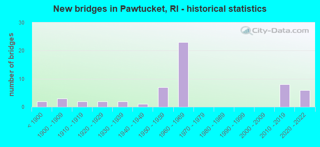
- New bridges - historical statistics
- 2Before 1900
- 31900-1909
- 21910-1919
- 21920-1929
- 21930-1939
- 11940-1949
- 71950-1959
- 231960-1969
- 82010-2019
- 62020-2022

- Reconstructed bridges - Historical Statistics
- 11960-1969
- 21970-1979
- 91980-1989
- 21990-1999
- 92000-2009


- Bridge Condition - Deck
- 16.2%Very good
- 48.6%Good
- 21.6%Satisfactory
- 13.5%Fair

- Bridge Condition - Superstructure
- 16.7%Very good
- 19.0%Good
- 21.4%Satisfactory
- 31.0%Fair
- 9.5%Poor
- 2.4%Serious

- Bridge Condition - Substructure
- 11.9%Very good
- 23.8%Good
- 33.3%Satisfactory
- 26.2%Fair
- 4.8%Poor

- Bridge Condition - Channel
- 23.1%Good
- 38.5%Satisfactory
- 38.5%Fair
Find on map >> Show street view
Structure Number: 545, Location: 0.3 Mi S of JCT Shnnck Rd (Lat: 41.459344, Lng: -71.663797), Route carried "on" structure: State highway 112, Year Built: 2018, Status: Open, Structure Length: 0.98m (3.22ft), Average Daily Traffic: 3,603 (year 2021), Truck Traffic: 8%, Average Future Daily Traffic: 3,963 (year 2041), Design Load: HS 25 or greater, Features Intersected: MILL CANAL
Minimum Vertical Clearance: 30+ m (98+ ft), Kilometerpoint: 8.970, Lanes on structure: 2, Owner: State Highway Agency, Approaching Roadway Width: 10.1m (33.1ft), Material/Design: Prestressed concrete, Design/Construction: Box Beam or Girders - Multiple, Number Of Spans In Main Unit: 1, Length of Maximum Span: 8.5m (27.9ft), Curb or Sidewalk Widths: Left: 1.7m (5.6ft), Right: 1.7m (5.6ft), Curb-To-Curb Width: 10.1m (33.1ft), Out-to-Out Width: 14.4m (47.2ft)
Condition: Deck: Very good, Superstructure: Very good, Substructure: Good, Channel: Good, Operating Rating: 97.2 metric tons, Method Used To Determine Operating Rating: Load and Resistance Factor Rating (LRFR) rating reported by rating factor(RF) method using HL-93 loadings, Inventory Rating: 76.1 metric tons, Method Used To Determine Inventory Rating: Load and Resistance Factor Rating (LRFR) rating reported by rating factor(RF) method using HL-93 loadings, Structural Evaluation: Better than present minimum criteria, Deck Geometry: Meets minimum limits, Waterway Adequacy: Equal to present desirable criteria, Approach Roadway Alignment: Equal to present minimum criteria, Length Of Structure Improvement: 0.76m (2.49ft), Designated Inspection Frequency: Every 24 months, Inspection Date: November 2021, Bridge Improvement Cost: $212,000, Roadway Improvement Cost: $21,000, Total Project Cost: $318,000, Deck Structure Type: Concrete Cast-file-Place, Wearing Surface/Protective System: Wearing Surface: Integral Concrete, Deck Protection: Galvanized Reinforcing
Find on map >> Show street view
Structure Number: 555, Location: 0.3 Mi S of JCT Shnnck Rd (Lat: 41.458931, Lng: -71.663797), Route carried "on" structure: State highway 112, Year Built: 2018, Status: Open, Structure Length: 1.81m (5.94ft), Average Daily Traffic: 3,603 (year 2021), Truck Traffic: 8%, Average Future Daily Traffic: 3,963 (year 2041), Design Load: HL 93, Features Intersected: MILL CANAL
Minimum Vertical Clearance: 30+ m (98+ ft), Kilometerpoint: 8.925, Lanes on structure: 2, Owner: State Highway Agency, Approaching Roadway Width: 10.1m (33.1ft), Skew: 1 degrees, Material/Design: Prestressed concrete, Design/Construction: Box Beam or Girders - Multiple, Number Of Spans In Main Unit: 2, Length of Maximum Span: 8.1m (26.6ft), Curb or Sidewalk Widths: Left: 1.7m (5.6ft), Right: 1.7m (5.6ft), Curb-To-Curb Width: 10.1m (33.1ft), Out-to-Out Width: 14.6m (47.9ft)
Condition: Deck: Good, Superstructure: Very good, Substructure: Satisfactory, Channel: Satisfactory, Operating Rating: 68.0 metric tons, Method Used To Determine Operating Rating: Load and Resistance Factor Rating (LRFR) rating reported by rating factor(RF) method using HL-93 loadings, Inventory Rating: 47.0 metric tons, Method Used To Determine Inventory Rating: Load and Resistance Factor Rating (LRFR) rating reported by rating factor(RF) method using HL-93 loadings, Structural Evaluation: Equal to present minimum criteria, Deck Geometry: Meets minimum limits, Waterway Adequacy: Superior to present desirable criteria, Approach Roadway Alignment: Equal to present minimum criteria, Length Of Structure Improvement: 1.68m (5.51ft), Designated Inspection Frequency: Every 24 months, Inspection Date: November 2021, Bridge Improvement Cost: $226,000, Roadway Improvement Cost: $23,000, Total Project Cost: $339,000, Deck Structure Type: Concrete Cast-file-Place, Wearing Surface/Protective System: Wearing Surface: Integral Concrete, Deck Protection: Galvanized Reinforcing
Find on map >> Show street view
Structure Number: 406, Location: 0.75 Mi E of JCT US 1A (Lat: 41.890236, Lng: -71.340144), Route carried "on" structure: City street , Year Built: 1947, Year Reconstructed: 1986, Status: Open, Structure Length: 1.16m (3.81ft), Average Daily Traffic: 15,757 (year 2014), Truck Traffic: 1%, Average Future Daily Traffic: 18,909 (year 2036), Design Load: HS 20, Features Intersected: TEN MILE RIVER, Facility Carried by Structure: CENTRAL AV
Minimum Vertical Clearance: 30+ m (98+ ft), Kilometerpoint: 2.697, Lanes on structure: 2, Owner: State Highway Agency, Approaching Roadway Width: 13.4m (44.0ft), Skew: 1 degrees, Material/Design: Concrete, Design/Construction: Tee Beam, Number Of Spans In Main Unit: 1, Length of Maximum Span: 11.2m (36.7ft), Curb or Sidewalk Widths: Left: 2.1m (6.9ft), Right: 2.1m (6.9ft), Curb-To-Curb Width: 13.4m (44.0ft), Out-to-Out Width: 18.4m (60.4ft)
Condition: Deck: Satisfactory, Superstructure: Fair, Substructure: Fair, Channel: Satisfactory, Operating Rating: 45.7 metric tons, Method Used To Determine Operating Rating: Load and Resistance Factor Rating (LRFR) rating reported by rating factor(RF) method using HL-93 loadings, Inventory Rating: 32.4 metric tons, Method Used To Determine Inventory Rating: Load and Resistance Factor Rating (LRFR) rating reported by rating factor(RF) method using HL-93 loadings, Structural Evaluation: Somewhat better than minimum adequacy, Deck Geometry: Equal to present minimum criteria, Waterway Adequacy: Equal to present desirable criteria, Approach Roadway Alignment: Equal to present desirable criteria, Length Of Structure Improvement: 1.16m (3.81ft), Designated Inspection Frequency: Every 24 months, Inspection Date: March 2020, Total Project Cost: $665,000, Deck Structure Type: Concrete Cast-file-Place, Wearing Surface/Protective System: Wearing Surface: Bituminous
Find on map >> Show street view
Structure Number: 543, Location: 1.5 Mi S of JCT Seekonk R (Lat: 41.864333, Lng: -71.403833), Route carried "on" structure: Interstate 95, Year Built: 1963, Status: Open, Structure Length: 0.61m (2.00ft), Average Daily Traffic: 151,500 (year 2021), Truck Traffic: 16%, Average Future Daily Traffic: 166,650 (year 2041), Design Load: HS 20+Mod, Features Intersected: MOSHASSUCK RIVER
Minimum Vertical Clearance: 30+ m (98+ ft), Kilometerpoint: 64.935, Lanes on structure: 6, Base Highway Network: Yes, Owner: State Highway Agency, Approaching Roadway Width: 30.5m (100.1ft), Skew: 29 degrees, Material/Design: Concrete, Design/Construction: Arch - Deck, Number Of Spans In Main Unit: 1, Length of Maximum Span: 6.1m (20.0ft), Curb-To-Curb Width: 30.5m (100.1ft), Out-to-Out Width: 189.6m (622.0ft)
Condition: Superstructure: Fair, Substructure: Satisfactory, Channel: Fair, Operating Rating: 97.2 metric tons, Method Used To Determine Operating Rating: Load and Resistance Factor Rating (LRFR) rating reported by rating factor(RF) method using HL-93 loadings, Inventory Rating: 97.2 metric tons, Method Used To Determine Inventory Rating: Load and Resistance Factor Rating (LRFR) rating reported by rating factor(RF) method using HL-93 loadings, Structural Evaluation: Somewhat better than minimum adequacy, Deck Geometry: Superior to present desirable criteria, Waterway Adequacy: Superior to present desirable criteria, Approach Roadway Alignment: Equal to present desirable criteria, Length Of Structure Improvement: 0.61m (2.00ft), Designated Inspection Frequency: Every 24 months, Inspection Date: September 2020, Bridge Improvement Cost: $441,000, Roadway Improvement Cost: $44,000, Total Project Cost: $591,000
Find on map >> Show street view
Structure Number: 544, Location: 2.5 Mi N of JCT RI 146 (Lat: 41.871614, Lng: -71.398361), Route carried "on" structure: State highway 122, Year Built: 1964, Status: Open, Structure Length: 4.30m (14.11ft), Average Daily Traffic: 19,853 (year 2021), Truck Traffic: 4%, Average Future Daily Traffic: 21,838 (year 2041), Design Load: HS 20, Features Intersected: I-95 NB & SB
Minimum Vertical Clearance: 30+ m (98+ ft), Kilometerpoint: 1.558, Lanes on structure: 2, Lanes under structure: 6, Owner: State Highway Agency, Approaching Roadway Width: 13.4m (44.0ft), Skew: 2 degrees, Material/Design: Steel, Design/Construction: Stringer/Multi-beam, Number Of Spans In Main Unit: 2, Length of Maximum Span: 21.0m (68.9ft), Curb or Sidewalk Widths: Left: 1.8m (5.9ft), Right: 1.8m (5.9ft), Curb-To-Curb Width: 13.4m (44.0ft), Out-to-Out Width: 17.7m (58.1ft)
Condition: Deck: Fair, Superstructure: Satisfactory, Substructure: Fair, Operating Rating: 61.9 metric tons, Method Used To Determine Operating Rating: Load and Resistance Factor Rating (LRFR) rating reported by rating factor(RF) method using HL-93 loadings, Inventory Rating: 48.0 metric tons, Method Used To Determine Inventory Rating: Load and Resistance Factor Rating (LRFR) rating reported by rating factor(RF) method using HL-93 loadings, Structural Evaluation: Somewhat better than minimum adequacy, Deck Geometry: Equal to present minimum criteria, Underclear: High priority of corrective action, Approach Roadway Alignment: Equal to present minimum criteria, Length Of Structure Improvement: 4.15m (13.62ft), Designated Inspection Frequency: Every 24 months, Inspection Date: October 2021, Bridge Improvement Cost: $2,375,000, Roadway Improvement Cost: $238,000, Total Project Cost: $3,563,000, Deck Structure Type: Concrete Cast-file-Place, Wearing Surface/Protective System: Wearing Surface: Bituminous, Membrane: Built-up
Find on map >> Show street view
Structure Number: 545, Location: 2.0 Mi N of JCT RI 146 (Lat: 41.872167, Lng: -71.396194), Route carried "on" structure: City street , Year Built: 1964, Status: Open, Structure Length: 3.72m (12.20ft), Average Daily Traffic: 600 (year 2008), Truck Traffic: 10%, Average Future Daily Traffic: 720 (year 2036), Design Load: HS 20, Features Intersected: I-95 NB & SB, Facility Carried by Structure: SLATER ST
Minimum Vertical Clearance: 30+ m (98+ ft), Kilometerpoint: 0.150, Lanes on structure: 2, Lanes under structure: 6, Owner: State Highway Agency, Approaching Roadway Width: 9.8m (32.2ft), Material/Design: Prestressed concrete, Design/Construction: Stringer/Multi-beam, Number Of Spans In Main Unit: 2, Length of Maximum Span: 17.4m (57.1ft), Curb or Sidewalk Widths: Left: 1.8m (5.9ft), Right: 1.8m (5.9ft), Curb-To-Curb Width: 9.8m (32.2ft), Out-to-Out Width: 14.0m (45.9ft)
Condition: Deck: Fair, Superstructure: Satisfactory, Substructure: Satisfactory, Operating Rating: 59.0 metric tons, Method Used To Determine Operating Rating: Load and Resistance Factor Rating (LRFR) rating reported by rating factor(RF) method using HL-93 loadings, Inventory Rating: 45.7 metric tons, Method Used To Determine Inventory Rating: Load and Resistance Factor Rating (LRFR) rating reported by rating factor(RF) method using HL-93 loadings, Structural Evaluation: Equal to present minimum criteria, Deck Geometry: Equal to present minimum criteria, Underclear: High priority of corrective action, Approach Roadway Alignment: Equal to present desirable criteria, Length Of Structure Improvement: 3.60m (11.81ft), Designated Inspection Frequency: Every 24 months, Inspection Date: October 2021, Total Project Cost: $1,626,000, Deck Structure Type: Concrete Cast-file-Place, Wearing Surface/Protective System: Wearing Surface: Bituminous, Membrane: Built-up
Find on map >> Show street view
Structure Number: 546, Location: 1.0 Mi S of MASS LINE (Lat: 41.872428, Lng: -71.394586), Route carried "on" structure: City street , Year Built: 1964, Status: Open, Structure Length: 5.64m (18.50ft), Average Daily Traffic: 17,070 (year 2015), Truck Traffic: 10%, Average Future Daily Traffic: 20,484 (year 2036), Design Load: HS 20, Features Intersected: I-95 NB & SB, Facility Carried by Structure: MAIN ST
Minimum Vertical Clearance: 30.48m (100.00ft), Kilometerpoint: 1.048, Lanes on structure: 2, Lanes under structure: 8, Owner: State Highway Agency, Approaching Roadway Width: 16.8m (55.1ft), Skew: 4 degrees, Material/Design: Steel, Design/Construction: Stringer/Multi-beam, Number Of Spans In Main Unit: 2, Length of Maximum Span: 27.1m (88.9ft), Curb or Sidewalk Widths: Left: 1.8m (5.9ft), Right: 1.8m (5.9ft), Curb-To-Curb Width: 16.8m (55.1ft), Out-to-Out Width: 17.7m (58.1ft)
Condition: Deck: Satisfactory, Superstructure: Fair, Substructure: Satisfactory, Operating Rating: 60.9 metric tons, Method Used To Determine Operating Rating: Load and Resistance Factor Rating (LRFR) rating reported by rating factor(RF) method using HL-93 loadings, Inventory Rating: 47.0 metric tons, Method Used To Determine Inventory Rating: Load and Resistance Factor Rating (LRFR) rating reported by rating factor(RF) method using HL-93 loadings, Structural Evaluation: Somewhat better than minimum adequacy, Deck Geometry: Superior to present desirable criteria, Underclear: High priority of corrective action, Approach Roadway Alignment: Equal to present minimum criteria, Length Of Structure Improvement: 5.64m (18.50ft), Designated Inspection Frequency: Every 24 months, Inspection Date: October 2021, Bridge Improvement Cost: $3,115,000, Roadway Improvement Cost: $312,000, Total Project Cost: $4,673,000, Deck Structure Type: Concrete Cast-file-Place, Wearing Surface/Protective System: Wearing Surface: Bituminous, Membrane: Built-up
Find on map >> Show street view
Structure Number: 547, Location: 1.1 Mi S of MASS LINE (Lat: 41.873056, Lng: -71.390556), Route carried "on" structure: City street , Year Built: 1964, Year Reconstructed: 2012, Status: Open, Structure Length: 5.67m (18.60ft), Average Daily Traffic: 2,727 (year 2015), Truck Traffic: 10%, Average Future Daily Traffic: 3,273 (year 2036), Design Load: HS 20, Features Intersected: I-95 NB & SB, Facility Carried by Structure: GARDEN ST
Minimum Vertical Clearance: 30+ m (98+ ft), Kilometerpoint: 0.309, Lanes on structure: 3, Lanes under structure: 7, Owner: State Highway Agency, Approaching Roadway Width: 12.2m (40.0ft), Material/Design: Steel, Design/Construction: Stringer/Multi-beam, Number Of Spans In Main Unit: 4, Length of Maximum Span: 17.7m (58.1ft), Curb or Sidewalk Widths: Left: 1.8m (5.9ft), Right: 1.8m (5.9ft), Curb-To-Curb Width: 12.2m (40.0ft), Out-to-Out Width: 16.5m (54.1ft)
Condition: Deck: Good, Superstructure: Fair, Substructure: Good, Operating Rating: 73.5 metric tons, Method Used To Determine Operating Rating: Load and Resistance Factor Rating (LRFR) rating reported by rating factor(RF) method using HL-93 loadings, Inventory Rating: 56.7 metric tons, Method Used To Determine Inventory Rating: Load and Resistance Factor Rating (LRFR) rating reported by rating factor(RF) method using HL-93 loadings, Structural Evaluation: Somewhat better than minimum adequacy, Deck Geometry: Meets minimum limits, Underclear: High priority of corrective action, Approach Roadway Alignment: Equal to present desirable criteria, Length Of Structure Improvement: 5.70m (18.70ft), Designated Inspection Frequency: Every 24 months, Inspection Date: October 2021, Bridge Improvement Cost: $1,984,000, Roadway Improvement Cost: $198,000, Total Project Cost: $2,975,000, Deck Structure Type: Concrete Cast-file-Place, Wearing Surface/Protective System: Wearing Surface: Bituminous, Membrane: Built-up, Deck Protection: Galvanized Reinforcing
Find on map >> Show street view
Structure Number: 5485, Location: 0.2 Mi S of JCT RI 15 (Lat: 41.873086, Lng: -71.389714), Route carried "on" structure: City street , Year Built: 2018, Status: Open, Structure Length: 4.71m (15.45ft), Average Daily Traffic: 6,060 (year 2014), Truck Traffic: 10%, Average Future Daily Traffic: 7,272 (year 2036), Design Load: HL 93, Features Intersected: I-95 NB & SB, Facility Carried by Structure: PINE ST
Minimum Vertical Clearance: 30+ m (98+ ft), Kilometerpoint: 0.330, Lanes on structure: 3, Lanes under structure: 7, Owner: State Highway Agency, Approaching Roadway Width: 12.2m (40.0ft), Material/Design: Steel, Design/Construction: Stringer/Multi-beam, Number Of Spans In Main Unit: 2, Length of Maximum Span: 22.6m (74.1ft), Curb or Sidewalk Widths: Left: 1.8m (5.9ft), Right: 1.8m (5.9ft), Curb-To-Curb Width: 12.2m (40.0ft), Out-to-Out Width: 16.5m (54.1ft)
Condition: Deck: Very good, Superstructure: Very good, Substructure: Very good, Operating Rating: 69.3 metric tons, Method Used To Determine Operating Rating: Load and Resistance Factor Rating (LRFR) rating reported by rating factor(RF) method using HL-93 loadings, Inventory Rating: 53.5 metric tons, Method Used To Determine Inventory Rating: Load and Resistance Factor Rating (LRFR) rating reported by rating factor(RF) method using HL-93 loadings, Structural Evaluation: Equal to present desirable criteria, Deck Geometry: Meets minimum limits, Underclear: High priority of corrective action, Approach Roadway Alignment: Equal to present desirable criteria, Length Of Structure Improvement: 5.76m (18.90ft), Designated Inspection Frequency: Every 24 months, Inspection Date: November 2021, Bridge Improvement Cost: $2,894,000, Roadway Improvement Cost: $289,000, Total Project Cost: $4,341,000, Deck Structure Type: Concrete Precast Panels, Wearing Surface/Protective System: Wearing Surface: Bituminous, Membrane: Built-up, Deck Protection: Galvanized Reinforcing
Find on map >> Show street view
Structure Number: 549, Location: 2.0 Mi N of RI 146 (Lat: 41.873078, Lng: -71.387564), Route carried "on" structure: City street 1, Year Built: 1964, Year Reconstructed: 2012, Status: Open, Structure Length: 5.52m (18.11ft), Average Daily Traffic: 10,909 (year 2014), Truck Traffic: 1%, Average Future Daily Traffic: 13,091 (year 2036), Design Load: HL 93, Features Intersected: I-95 NB & SB, Facility Carried by Structure: GEORGE ST
Minimum Vertical Clearance: 30+ m (98+ ft), Kilometerpoint: 88.952, Lanes on structure: 4, Lanes under structure: 7, Base Highway Network: Yes, Owner: State Highway Agency, Approaching Roadway Width: 16.5m (54.1ft), Skew: 20 degrees, Material/Design: Prestressed concrete, Design/Construction: Box Beam or Girders - Multiple, Number Of Spans In Main Unit: 2, Length of Maximum Span: 26.9m (88.3ft), Curb or Sidewalk Widths: Left: 2.1m (6.9ft), Right: 2.1m (6.9ft), Curb-To-Curb Width: 16.5m (54.1ft), Out-to-Out Width: 21.9m (71.9ft)
Condition: Deck: Fair, Superstructure: Satisfactory, Substructure: Good, Operating Rating: 54.8 metric tons, Method Used To Determine Operating Rating: Load and Resistance Factor Rating (LRFR) rating reported by rating factor(RF) method using HL-93 loadings, Inventory Rating: 42.1 metric tons, Method Used To Determine Inventory Rating: Load and Resistance Factor Rating (LRFR) rating reported by rating factor(RF) method using HL-93 loadings, Structural Evaluation: Equal to present minimum criteria, Deck Geometry: Meets minimum limits, Underclear: High priority of corrective action, Approach Roadway Alignment: Equal to present minimum criteria, Length Of Structure Improvement: 5.58m (18.31ft), Designated Inspection Frequency: Every 24 months, Inspection Date: September 2020, Bridge Improvement Cost: $2,528,000, Roadway Improvement Cost: $253,000, Total Project Cost: $3,793,000, Deck Structure Type: Concrete Cast-file-Place, Wearing Surface/Protective System: Deck Protection: Galvanized Reinforcing
Find on map >> Show street view
Structure Number: 55, Location: 1.0 Mi S of Mass Line (Lat: 41.873419, Lng: -71.384350), Route carried "on" structure: Interstate 95, Year Built: 2013, Status: Open, Structure Length: 10.87m (35.66ft), Average Daily Traffic: 116,900 (year 2015), Truck Traffic: 1%, Average Future Daily Traffic: 140,280 (year 2036), Design Load: HL 93, Features Intersected: TAFT ST & SEEKONK RIVER
Minimum Vertical Clearance: 5.18m (16.99ft), Kilometerpoint: 67.026, Lanes on structure: 8, Lanes under structure: 2, Base Highway Network: Yes, Owner: State Highway Agency, Approaching Roadway Width: 42.1m (138.1ft), Skew: 30 degrees, Material/Design: Steel, Design/Construction: Arch - Deck, Number Of Spans In Main Unit: 1, Length of Maximum Span: 107.1m (351.4ft), Curb-To-Curb Width: 42.1m (138.1ft), Out-to-Out Width: 45.9m (150.6ft)
Condition: Deck: Good, Superstructure: Good, Substructure: Good, Channel: Good, Operating Rating: 59.3 metric tons, Method Used To Determine Operating Rating: Load and Resistance Factor Rating (LRFR) rating reported by rating factor(RF) method using HL-93 loadings, Inventory Rating: 45.7 metric tons, Method Used To Determine Inventory Rating: Load and Resistance Factor Rating (LRFR) rating reported by rating factor(RF) method using HL-93 loadings, Structural Evaluation: Better than present minimum criteria, Deck Geometry: Equal to present desirable criteria, Underclear: Somewhat better than minimum adequacy, Waterway Adequacy: Superior to present desirable criteria, Approach Roadway Alignment: Equal to present minimum criteria, Length Of Structure Improvement: 21.34m (70.01ft), Designated Inspection Frequency: Every 24 months, Inspection Date: July 2020, Bridge Improvement Cost: $14,700,000, Roadway Improvement Cost: $1,470,000, Total Project Cost: $22,051,000, Deck Structure Type: Concrete Precast Panels, Wearing Surface/Protective System: Wearing Surface: Bituminous, Membrane: Epoxy, Deck Protection: Galvanized Reinforcing
Find on map >> Show street view
Structure Number: 552, Location: 0.2 Mi N of JCT Seekonk R (Lat: 41.873969, Lng: -71.381747), Route carried "on" structure: Interstate 95, Year Built: 1958, Year Reconstructed: 1986, Status: Open, Structure Length: 3.63m (11.91ft), Average Daily Traffic: 126,200 (year 2021), Truck Traffic: 25%, Average Future Daily Traffic: 138,820 (year 2041), Design Load: HS 20, Features Intersected: WATER ST
Minimum Vertical Clearance: 30+ m (98+ ft), Kilometerpoint: 67.261, Lanes on structure: 6, Lanes under structure: 2, Base Highway Network: Yes, Owner: State Highway Agency, Approaching Roadway Width: 30.5m (100.1ft), Skew: 37 degrees, Material/Design: Steel continuous, Design/Construction: Stringer/Multi-beam, Number Of Spans In Main Unit: 3, Length of Maximum Span: 14.0m (45.9ft), Curb-To-Curb Width: 30.5m (100.1ft), Out-to-Out Width: 32.8m (107.6ft)
Condition: Deck: Satisfactory, Superstructure: Fair, Substructure: Fair, Operating Rating: 28.2 metric tons, Method Used To Determine Operating Rating: Load and Resistance Factor Rating (LRFR) rating reported by rating factor(RF) method using HL-93 loadings, Inventory Rating: 21.7 metric tons, Method Used To Determine Inventory Rating: Load and Resistance Factor Rating (LRFR) rating reported by rating factor(RF) method using HL-93 loadings, Structural Evaluation: Somewhat better than minimum adequacy, Deck Geometry: Superior to present desirable criteria, Underclear: Somewhat better than minimum adequacy, Approach Roadway Alignment: Equal to present desirable criteria, Length Of Structure Improvement: 3.63m (11.91ft), Designated Inspection Frequency: Every 24 months, Inspection Date: June 2021, Bridge Improvement Cost: $1,124,000, Roadway Improvement Cost: $112,000, Total Project Cost: $1,686,000, Deck Structure Type: Concrete Cast-file-Place, Wearing Surface/Protective System: Wearing Surface: Bituminous, Membrane: Preformed Fabric
Find on map >> Show street view
Structure Number: 5522, Location: 0.2 Mi N of JCT Seekonk R (Lat: 41.873781, Lng: -71.381725), Route carried "on" structure: Ramp Interstate 95, Year Built: 2013, Status: Open, Structure Length: 3.72m (12.20ft), Average Daily Traffic: 126,200 (year 2021), Truck Traffic: 25%, Average Future Daily Traffic: 138,820 (year 2041), Design Load: HL 93, Features Intersected: Water St, Facility Carried by Structure: CD-ROAD
Minimum Vertical Clearance: 30+ m (98+ ft), Kilometerpoint: 0.782, Lanes on structure: 1, Lanes under structure: 2, Owner: State Highway Agency, Approaching Roadway Width: 11.6m (38.1ft), Skew: 1 degrees, Material/Design: Prestressed concrete, Design/Construction: Stringer/Multi-beam, Number Of Spans In Main Unit: 1, Length of Maximum Span: 36.0m (118.1ft), Curb-To-Curb Width: 11.6m (38.1ft), Out-to-Out Width: 12.5m (41.0ft)
Condition: Deck: Good, Superstructure: Good, Substructure: Good, Operating Rating: 66.7 metric tons, Method Used To Determine Operating Rating: Load and Resistance Factor Rating (LRFR) rating reported by rating factor(RF) method using HL-93 loadings, Inventory Rating: 40.5 metric tons, Method Used To Determine Inventory Rating: Load and Resistance Factor Rating (LRFR) rating reported by rating factor(RF) method using HL-93 loadings, Structural Evaluation: Better than present minimum criteria, Deck Geometry: Superior to present desirable criteria, Underclear: Superior to present desirable criteria, Approach Roadway Alignment: Better than present minimum criteria, Designated Inspection Frequency: Every 24 months, Inspection Date: June 2021, Deck Structure Type: Concrete Cast-file-Place, Wearing Surface/Protective System: Wearing Surface: Bituminous, Membrane: Preformed Fabric, Deck Protection: Galvanized Reinforcing
Find on map >> Show street view
Structure Number: 553, Location: 0.1 Mi N of JCT Seekonk R (Lat: 41.873700, Lng: -71.381697), Route carried "on" structure: Ramp City street 95, Year Built: 1958, Year Reconstructed: 2012, Status: Open, Structure Length: 2.87m (9.42ft), Average Daily Traffic: 18,244 (year 2015), Truck Traffic: 2%, Average Future Daily Traffic: 21,893 (year 2036), Design Load: HL 93, Features Intersected: WATER ST
Minimum Vertical Clearance: 30+ m (98+ ft), Kilometerpoint: 0.190, Lanes on structure: 1, Lanes under structure: 2, Owner: State Highway Agency, Approaching Roadway Width: 7.3m (24.0ft), Skew: 1 degrees, Material/Design: Prestressed concrete, Design/Construction: Stringer/Multi-beam, Number Of Spans In Main Unit: 1, Length of Maximum Span: 27.1m (88.9ft), Curb-To-Curb Width: 7.3m (24.0ft), Out-to-Out Width: 8.3m (27.2ft)
Condition: Deck: Good, Superstructure: Good, Substructure: Good, Operating Rating: 75.1 metric tons, Method Used To Determine Operating Rating: Load and Resistance Factor (LRFR), Inventory Rating: 57.8 metric tons, Method Used To Determine Inventory Rating: Load and Resistance Factor (LRFR), Structural Evaluation: Better than present minimum criteria, Deck Geometry: Better than present minimum criteria, Underclear: Better than present minimum criteria, Approach Roadway Alignment: Equal to present desirable criteria, Length Of Structure Improvement: 2.83m (9.28ft), Designated Inspection Frequency: Every 24 months, Inspection Date: June 2021, Bridge Improvement Cost: $395,000, Roadway Improvement Cost: $40,000, Total Project Cost: $593,000, Deck Structure Type: Concrete Cast-file-Place, Wearing Surface/Protective System: Deck Protection: Epoxy Coated Reinforcing
Find on map >> Show street view
Structure Number: 554, Location: 0.1 Mi N of JCT Seekonk R (Lat: 41.874322, Lng: -71.381069), Route carried "on" structure: Interstate 95, Year Built: 1958, Year Reconstructed: 2012, Status: Open, Structure Length: 1.58m (5.18ft), Average Daily Traffic: 126,200 (year 2021), Truck Traffic: 25%, Average Future Daily Traffic: 138,820 (year 2041), Design Load: HS 20, Features Intersected: SCHOOL ST
Minimum Vertical Clearance: 30+ m (98+ ft), Kilometerpoint: 67.329, Lanes on structure: 7, Lanes under structure: 2, Base Highway Network: Yes, Owner: State Highway Agency, Approaching Roadway Width: 43.6m (143.0ft), Skew: 32 degrees, Material/Design: Steel, Design/Construction: Stringer/Multi-beam, Number Of Spans In Main Unit: 1, Length of Maximum Span: 14.3m (46.9ft), Curb-To-Curb Width: 43.6m (143.0ft), Out-to-Out Width: 45.4m (149.0ft)
Condition: Deck: Satisfactory, Superstructure: Good, Substructure: Satisfactory, Operating Rating: 74.2 metric tons, Method Used To Determine Operating Rating: Load and Resistance Factor Rating (LRFR) rating reported by rating factor(RF) method using HL-93 loadings, Inventory Rating: 57.0 metric tons, Method Used To Determine Inventory Rating: Load and Resistance Factor Rating (LRFR) rating reported by rating factor(RF) method using HL-93 loadings, Structural Evaluation: Equal to present minimum criteria, Deck Geometry: Superior to present desirable criteria, Underclear: Meets minimum limits, Approach Roadway Alignment: Equal to present desirable criteria, Length Of Structure Improvement: 1.58m (5.18ft), Designated Inspection Frequency: Every 24 months, Inspection Date: June 2021, Bridge Improvement Cost: $1,082,000, Roadway Improvement Cost: $108,000, Total Project Cost: $1,623,000, Deck Structure Type: Concrete Cast-file-Place, Wearing Surface/Protective System: Wearing Surface: Bituminous, Membrane: Preformed Fabric
Find on map >> Show street view
Structure Number: 555, Location: 0.1 Mi E of BROADWAY INT (Lat: 41.876631, Lng: -71.379436), Route carried "on" structure: Alternate US 1, Year Built: 1958, Year Reconstructed: 1986, Status: Open, Structure Length: 4.24m (13.91ft), Average Daily Traffic: 13,837 (year 2014), Truck Traffic: 2%, Average Future Daily Traffic: 16,605 (year 2036), Design Load: HS 20, Features Intersected: I-95 NB & SB, Facility Carried by Structure: WALCOTT ST
Minimum Vertical Clearance: 30+ m (98+ ft), Kilometerpoint: 90.043, Lanes on structure: 4, Lanes under structure: 7, Base Highway Network: Yes, Owner: State Highway Agency, Approaching Roadway Width: 15.8m (51.8ft), Skew: 22 degrees, Material/Design: Steel, Design/Construction: Stringer/Multi-beam, Number Of Spans In Main Unit: 2, Length of Maximum Span: 20.5m (67.3ft), Curb or Sidewalk Widths: Left: 1.8m (5.9ft), Right: 1.8m (5.9ft), Curb-To-Curb Width: 15.8m (51.8ft), Out-to-Out Width: 20.1m (65.9ft)
Condition: Deck: Satisfactory, Superstructure: Fair, Substructure: Satisfactory, Operating Rating: 37.9 metric tons, Method Used To Determine Operating Rating: Load and Resistance Factor Rating (LRFR) rating reported by rating factor(RF) method using HL-93 loadings, Inventory Rating: 29.2 metric tons, Method Used To Determine Inventory Rating: Load and Resistance Factor Rating (LRFR) rating reported by rating factor(RF) method using HL-93 loadings, Structural Evaluation: Somewhat better than minimum adequacy, Deck Geometry: Meets minimum limits, Underclear: High priority of corrective action, Approach Roadway Alignment: Equal to present minimum criteria, Length Of Structure Improvement: 4.08m (13.39ft), Designated Inspection Frequency: Every 24 months, Inspection Date: October 2021, Bridge Improvement Cost: $1,740,000, Roadway Improvement Cost: $174,000, Total Project Cost: $2,610,000, Deck Structure Type: Concrete Cast-file-Place, Wearing Surface/Protective System: Wearing Surface: Bituminous, Membrane: Preformed Fabric, Deck Protection: Epoxy Coated Reinforcing
Find on map >> Show street view
Structure Number: 556, Location: 0.5 Mi N of SEEKONK RIVER (Lat: 41.878056, Lng: -71.378900), Route carried "on" structure: Alternate State highway 114, Year Built: 1964, Year Reconstructed: 2005, Status: Open, Structure Length: 5.09m (16.70ft), Average Daily Traffic: 1,919 (year 2014), Truck Traffic: 3%, Average Future Daily Traffic: 2,303 (year 2036), Design Load: HS 20, Features Intersected: I-95 NB & SB, Facility Carried by Structure: UNDERWOOD ST
Minimum Vertical Clearance: 30+ m (98+ ft), Kilometerpoint: 9.708, Lanes on structure: 2, Lanes under structure: 8, Owner: State Highway Agency, Approaching Roadway Width: 10.4m (34.1ft), Material/Design: Steel, Design/Construction: Stringer/Multi-beam, Number Of Spans In Main Unit: 3, Length of Maximum Span: 24.4m (80.1ft), Curb or Sidewalk Widths: Left: 1.8m (5.9ft), Right: 1.8m (5.9ft), Curb-To-Curb Width: 10.4m (34.1ft), Out-to-Out Width: 15.1m (49.5ft)
Condition: Deck: Good, Superstructure: Fair, Substructure: Satisfactory, Operating Rating: 36.6 metric tons, Method Used To Determine Operating Rating: Load and Resistance Factor Rating (LRFR) rating reported by rating factor(RF) method using HL-93 loadings, Inventory Rating: 28.2 metric tons, Method Used To Determine Inventory Rating: Load and Resistance Factor Rating (LRFR) rating reported by rating factor(RF) method using HL-93 loadings, Structural Evaluation: Somewhat better than minimum adequacy, Deck Geometry: Somewhat better than minimum adequacy, Underclear: High priority of corrective action, Approach Roadway Alignment: Equal to present minimum criteria, Length Of Structure Improvement: 5.09m (16.70ft), Designated Inspection Frequency: Every 24 months, Inspection Date: November 2021, Bridge Improvement Cost: $1,600,000, Roadway Improvement Cost: $160,000, Total Project Cost: $2,400,000, Deck Structure Type: Concrete Cast-file-Place, Wearing Surface/Protective System: Wearing Surface: Bituminous, Membrane: Preformed Fabric
Find on map >> Show street view
Structure Number: 557, Location: 0.4 Mi S of MASS. LINE (Lat: 41.879494, Lng: -71.378161), Route carried "on" structure: City street , Year Built: 1958, Year Reconstructed: 2005, Status: Open, Structure Length: 3.63m (11.91ft), Average Daily Traffic: 16,040 (year 2015), Truck Traffic: 2%, Average Future Daily Traffic: 19,248 (year 2036), Design Load: HS 20, Features Intersected: I-95 NB & SB, Facility Carried by Structure: EXCHANGE ST
Minimum Vertical Clearance: 30+ m (98+ ft), Kilometerpoint: 0.385, Lanes on structure: 2, Lanes under structure: 7, Owner: State Highway Agency, Approaching Roadway Width: 10.4m (34.1ft), Material/Design: Steel, Design/Construction: Stringer/Multi-beam, Number Of Spans In Main Unit: 2, Length of Maximum Span: 17.8m (58.4ft), Curb or Sidewalk Widths: Left: 1.8m (5.9ft), Right: 1.8m (5.9ft), Curb-To-Curb Width: 10.4m (34.1ft), Out-to-Out Width: 14.6m (47.9ft)
Condition: Deck: Good, Superstructure: Fair, Substructure: Satisfactory, Operating Rating: 50.5 metric tons, Method Used To Determine Operating Rating: Load and Resistance Factor Rating (LRFR) rating reported by rating factor(RF) method using HL-93 loadings, Inventory Rating: 39.2 metric tons, Method Used To Determine Inventory Rating: Load and Resistance Factor Rating (LRFR) rating reported by rating factor(RF) method using HL-93 loadings, Structural Evaluation: Somewhat better than minimum adequacy, Deck Geometry: Somewhat better than minimum adequacy, Underclear: High priority of corrective action, Approach Roadway Alignment: Better than present minimum criteria, Length Of Structure Improvement: 3.63m (11.91ft), Designated Inspection Frequency: Every 24 months, Inspection Date: November 2021, Bridge Improvement Cost: $1,140,000, Roadway Improvement Cost: $114,000, Total Project Cost: $1,711,000, Deck Structure Type: Concrete Cast-file-Place, Wearing Surface/Protective System: Wearing Surface: Bituminous, Membrane: Preformed Fabric
Find on map >> Show street view
Structure Number: 558, Location: 1.0 Mi S of MASS LINE (Lat: 41.882350, Lng: -71.377456), Route carried "on" structure: US 1, Year Built: 1964, Year Reconstructed: 2006, Status: Open, Structure Length: 6.16m (20.21ft), Average Daily Traffic: 9,700 (year 2021), Truck Traffic: 4%, Average Future Daily Traffic: 10,670 (year 2041), Design Load: HS 20, Features Intersected: I-95 NB & SB
Minimum Vertical Clearance: 30+ m (98+ ft), Kilometerpoint: 0.126, Lanes on structure: 2, Lanes under structure: 6, Base Highway Network: Yes, Owner: State Highway Agency, Approaching Roadway Width: 14.0m (45.9ft), Skew: 5 degrees, Material/Design: Steel, Design/Construction: Stringer/Multi-beam, Number Of Spans In Main Unit: 2, Length of Maximum Span: 32.9m (107.9ft), Curb or Sidewalk Widths: Left: 1.8m (5.9ft), Right: 1.8m (5.9ft), Curb-To-Curb Width: 14.0m (45.9ft), Out-to-Out Width: 18.3m (60.0ft)
Condition: Deck: Good, Superstructure: Satisfactory, Substructure: Good, Operating Rating: 51.5 metric tons, Method Used To Determine Operating Rating: Load and Resistance Factor Rating (LRFR) rating reported by rating factor(RF) method using HL-93 loadings, Inventory Rating: 39.5 metric tons, Method Used To Determine Inventory Rating: Load and Resistance Factor Rating (LRFR) rating reported by rating factor(RF) method using HL-93 loadings, Structural Evaluation: Equal to present minimum criteria, Deck Geometry: Superior to present desirable criteria, Underclear: High priority of corrective action, Approach Roadway Alignment: Equal to present desirable criteria, Length Of Structure Improvement: 6.16m (20.21ft), Designated Inspection Frequency: Every 24 months, Inspection Date: November 2021, Total Project Cost: $3,518,000, Deck Structure Type: Concrete Precast Panels, Wearing Surface/Protective System: Wearing Surface: Bituminous, Membrane: Other
Find on map >> Show street view
Structure Number: 559, Location: 0.1 Mi N of JCT US 1 (Lat: 41.883267, Lng: -71.378089), Route carried "on" structure: City street , Year Built: 1964, Year Reconstructed: 2006, Status: Open, Structure Length: 6.77m (22.21ft), Average Daily Traffic: 1,500 (year 2021), Truck Traffic: 3%, Average Future Daily Traffic: 1,650 (year 2041), Design Load: HS 20, Features Intersected: I-95 NB & SB, Facility Carried by Structure: FOUNTAIN ST
Minimum Vertical Clearance: 30+ m (98+ ft), Kilometerpoint: 0.418, Lanes on structure: 2, Lanes under structure: 6, Owner: State Highway Agency, Approaching Roadway Width: 9.8m (32.2ft), Skew: 5 degrees, Material/Design: Steel, Design/Construction: Stringer/Multi-beam, Number Of Spans In Main Unit: 2, Length of Maximum Span: 32.9m (107.9ft), Curb or Sidewalk Widths: Left: 1.8m (5.9ft), Right: 1.8m (5.9ft), Curb-To-Curb Width: 9.8m (32.2ft), Out-to-Out Width: 14.0m (45.9ft)
Condition: Deck: Good, Superstructure: Satisfactory, Substructure: Satisfactory, Operating Rating: 53.3 metric tons, Method Used To Determine Operating Rating: Load and Resistance Factor (LRFR), Inventory Rating: 41.4 metric tons, Method Used To Determine Inventory Rating: Load and Resistance Factor (LRFR), Structural Evaluation: Equal to present minimum criteria, Deck Geometry: Meets minimum limits, Underclear: High priority of corrective action, Approach Roadway Alignment: Better than present minimum criteria, Length Of Structure Improvement: 6.04m (19.82ft), Designated Inspection Frequency: Every 24 months, Inspection Date: November 2021, Total Project Cost: $2,959,000, Deck Structure Type: Concrete Cast-file-Place, Wearing Surface/Protective System: Wearing Surface: Bituminous, Membrane: Other
Find on map >> Show street view
Structure Number: 56, Location: 1.0 Mi S of MASS LINE (Lat: 41.885233, Lng: -71.378622), Route carried "on" structure: City street , Year Built: 1964, Year Reconstructed: 2005, Status: Open, Structure Length: 4.48m (14.70ft), Average Daily Traffic: 6,100 (year 2021), Truck Traffic: 2%, Average Future Daily Traffic: 6,710 (year 2041), Design Load: H 20, Features Intersected: I-95 NB & SB, Facility Carried by Structure: CENTRAL AV
Minimum Vertical Clearance: 30+ m (98+ ft), Kilometerpoint: 0.718, Lanes on structure: 2, Lanes under structure: 7, Owner: State Highway Agency, Approaching Roadway Width: 13.4m (44.0ft), Skew: 2 degrees, Material/Design: Steel, Design/Construction: Stringer/Multi-beam, Number Of Spans In Main Unit: 2, Length of Maximum Span: 22.9m (75.1ft), Curb or Sidewalk Widths: Left: 1.8m (5.9ft), Right: 1.8m (5.9ft), Curb-To-Curb Width: 13.4m (44.0ft), Out-to-Out Width: 17.7m (58.1ft)
Condition: Deck: Good, Superstructure: Satisfactory, Substructure: Satisfactory, Operating Rating: 67.4 metric tons, Method Used To Determine Operating Rating: Load and Resistance Factor Rating (LRFR) rating reported by rating factor(RF) method using HL-93 loadings, Inventory Rating: 51.8 metric tons, Method Used To Determine Inventory Rating: Load and Resistance Factor Rating (LRFR) rating reported by rating factor(RF) method using HL-93 loadings, Structural Evaluation: Equal to present minimum criteria, Deck Geometry: Equal to present minimum criteria, Underclear: High priority of corrective action, Approach Roadway Alignment: Equal to present desirable criteria, Length Of Structure Improvement: 4.48m (14.70ft), Designated Inspection Frequency: Every 24 months, Inspection Date: November 2021, Total Project Cost: $2,475,000, Deck Structure Type: Concrete Cast-file-Place, Wearing Surface/Protective System: Wearing Surface: Bituminous, Membrane: Other, Deck Protection: Epoxy Coated Reinforcing
Find on map >> Show street view
Structure Number: 5615, Location: 0.5 Mi S of Mass Line (Lat: 41.890169, Lng: -71.378869), Route carried "on" structure: Interstate 95, Year Built: 2020, Status: Open, Structure Length: 2.42m (7.94ft), Average Daily Traffic: 42,300 (year 2019), Truck Traffic: 15%, Average Future Daily Traffic: 46,530 (year 2039), Design Load: Greater than HL93, Features Intersected: EAST ST
Minimum Vertical Clearance: 30+ m (98+ ft), Kilometerpoint: 69.191, Lanes on structure: 3, Lanes under structure: 4, Base Highway Network: Yes, Owner: State Highway Agency, Approaching Roadway Width: 15.2m (49.9ft), Skew: 10 degrees, Material/Design: Steel, Design/Construction: Stringer/Multi-beam, Number Of Spans In Main Unit: 1, Length of Maximum Span: 23.0m (75.5ft), Curb-To-Curb Width: 15.2m (49.9ft), Out-to-Out Width: 16.2m (53.1ft)
Condition: Deck: Very good, Superstructure: Very good, Substructure: Very good, Operating Rating: 54.8 metric tons, Method Used To Determine Operating Rating: Load and Resistance Factor Rating (LRFR) rating reported by rating factor(RF) method using HL-93 loadings, Inventory Rating: 42.1 metric tons, Method Used To Determine Inventory Rating: Load and Resistance Factor Rating (LRFR) rating reported by rating factor(RF) method using HL-93 loadings, Structural Evaluation: Equal to present desirable criteria, Deck Geometry: Meets minimum limits, Underclear: High priority of corrective action, Approach Roadway Alignment: Equal to present desirable criteria, Length Of Structure Improvement: 3.72m (12.20ft), Designated Inspection Frequency: Every 24 months, Inspection Date: November 2021, Total Project Cost: $1,954,000, Deck Structure Type: Concrete Precast Panels, Wearing Surface/Protective System: Wearing Surface: Bituminous, Membrane: Preformed Fabric, Deck Protection: Galvanized Reinforcing
Find on map >> Show street view
Structure Number: 5617, Location: 0.5 Mi S of Mass Line (Lat: 41.890172, Lng: -71.379089), Route carried "on" structure: Interstate 95, Year Built: 2020, Status: Open, Structure Length: 2.42m (7.94ft), Average Daily Traffic: 82,660 (year 2019), Truck Traffic: 17%, Average Future Daily Traffic: 90,926 (year 2039), Design Load: Greater than HL93, Features Intersected: EAST ST
Minimum Vertical Clearance: 30+ m (98+ ft), Kilometerpoint: 0.531, Lanes on structure: 3, Lanes under structure: 4, Base Highway Network: Yes, Owner: State Highway Agency, Approaching Roadway Width: 15.2m (49.9ft), Material/Design: Steel, Design/Construction: Stringer/Multi-beam, Number Of Spans In Main Unit: 3, Length of Maximum Span: 23.0m (75.5ft), Curb-To-Curb Width: 15.2m (49.9ft), Out-to-Out Width: 16.2m (53.1ft)
Condition: Deck: Very good, Superstructure: Very good, Substructure: Very good, Operating Rating: 54.4 metric tons, Method Used To Determine Operating Rating: Load and Resistance Factor Rating (LRFR) rating reported by rating factor(RF) method using HL-93 loadings, Inventory Rating: 42.1 metric tons, Method Used To Determine Inventory Rating: Load and Resistance Factor Rating (LRFR) rating reported by rating factor(RF) method using HL-93 loadings, Structural Evaluation: Equal to present desirable criteria, Deck Geometry: Meets minimum limits, Underclear: High priority of corrective action, Approach Roadway Alignment: Equal to present desirable criteria, Length Of Structure Improvement: 3.72m (12.20ft), Designated Inspection Frequency: Every 24 months, Inspection Date: November 2021, Total Project Cost: $1,954,000, Deck Structure Type: Concrete Precast Panels, Wearing Surface/Protective System: Wearing Surface: Bituminous, Membrane: Preformed Fabric, Deck Protection: Galvanized Reinforcing
Find on map >> Show street view
Structure Number: 5625, Location: 0.3 Mi S of Mass Line (Lat: 41.893022, Lng: -71.377175), Route carried "on" structure: Interstate 95, Year Built: 2020, Status: Open, Structure Length: 2.59m (8.50ft), Average Daily Traffic: 42,300 (year 2019), Truck Traffic: 15%, Average Future Daily Traffic: 46,530 (year 2039), Design Load: Greater than HL93, Features Intersected: ROOSEVELT AV
Minimum Vertical Clearance: 30+ m (98+ ft), Kilometerpoint: 69.546, Lanes on structure: 3, Lanes under structure: 2, Base Highway Network: Yes, Owner: State Highway Agency, Approaching Roadway Width: 15.8m (51.8ft), Skew: 4 degrees, Material/Design: Steel, Design/Construction: Stringer/Multi-beam, Number Of Spans In Main Unit: 1, Length of Maximum Span: 25.3m (83.0ft), Curb-To-Curb Width: 15.8m (51.8ft), Out-to-Out Width: 16.8m (55.1ft)
Condition: Deck: Good, Superstructure: Good, Substructure: Good, Operating Rating: 50.5 metric tons, Method Used To Determine Operating Rating: Load and Resistance Factor Rating (LRFR) rating reported by rating factor(RF) method using HL-93 loadings, Inventory Rating: 38.9 metric tons, Method Used To Determine Inventory Rating: Load and Resistance Factor Rating (LRFR) rating reported by rating factor(RF) method using HL-93 loadings, Structural Evaluation: Better than present minimum criteria, Deck Geometry: Somewhat better than minimum adequacy, Underclear: High priority of corrective action, Approach Roadway Alignment: Equal to present desirable criteria, Length Of Structure Improvement: 4.21m (13.81ft), Designated Inspection Frequency: Every 24 months, Inspection Date: December 2021, Bridge Improvement Cost: $2,360,000, Roadway Improvement Cost: $236,000, Total Project Cost: $3,540,000, Deck Structure Type: Concrete Precast Panels, Wearing Surface/Protective System: Wearing Surface: Bituminous, Membrane: Preformed Fabric, Deck Protection: Galvanized Reinforcing
Find on map >> Show street view
Structure Number: 5627, Location: 0.3 Mi S of Mass Line (Lat: 41.893000, Lng: -71.377481), Route carried "on" structure: Interstate 95, Year Built: 2020, Status: Open, Structure Length: 2.59m (8.50ft), Average Daily Traffic: 89,125 (year 2016), Truck Traffic: 7%, Average Future Daily Traffic: 99,065 (year 2036), Design Load: Greater than HL93, Features Intersected: ROOSEVELT AV
Minimum Vertical Clearance: 30+ m (98+ ft), Kilometerpoint: 0.183, Lanes on structure: 3, Lanes under structure: 2, Base Highway Network: Yes, Owner: State Highway Agency, Approaching Roadway Width: 15.8m (51.8ft), Skew: 4 degrees, Material/Design: Steel, Design/Construction: Stringer/Multi-beam, Number Of Spans In Main Unit: 1, Length of Maximum Span: 24.7m (81.0ft), Curb-To-Curb Width: 15.8m (51.8ft), Out-to-Out Width: 16.8m (55.1ft)
Condition: Deck: Very good, Superstructure: Very good, Substructure: Very good, Operating Rating: 50.5 metric tons, Method Used To Determine Operating Rating: Load and Resistance Factor Rating (LRFR) rating reported by rating factor(RF) method using HL-93 loadings, Inventory Rating: 38.9 metric tons, Method Used To Determine Inventory Rating: Load and Resistance Factor Rating (LRFR) rating reported by rating factor(RF) method using HL-93 loadings, Structural Evaluation: Equal to present desirable criteria, Deck Geometry: Somewhat better than minimum adequacy, Underclear: High priority of corrective action, Approach Roadway Alignment: Equal to present minimum criteria, Length Of Structure Improvement: 4.21m (13.81ft), Designated Inspection Frequency: Every 24 months, Inspection Date: December 2021, Bridge Improvement Cost: $2,360,000, Roadway Improvement Cost: $236,000, Total Project Cost: $3,540,000, Deck Structure Type: Concrete Cast-file-Place, Wearing Surface/Protective System: Wearing Surface: Bituminous, Membrane: Preformed Fabric, Deck Protection: Galvanized Reinforcing
Find on map >> Show street view
Structure Number: 563, Location: 0.1 Mi S of Mass Line (Lat: 41.894008, Lng: -71.376258), Route carried "on" structure: Interstate 95, Year Built: 1961, Year Reconstructed: 1985, Status: Open, Structure Length: 8.84m (29.00ft), Average Daily Traffic: 48,250 (year 2015), Truck Traffic: 1%, Average Future Daily Traffic: 57,900 (year 2036), Design Load: HS 20, Features Intersected: AMTRAK & PLEASANT VW ST
Minimum Vertical Clearance: 30+ m (98+ ft), Kilometerpoint: 69.680, Lanes on structure: 3, Lanes under structure: 2, Base Highway Network: Yes, Owner: State Highway Agency, Approaching Roadway Width: 15.2m (49.9ft), Skew: 4 degrees, Material/Design: Steel, Design/Construction: Stringer/Multi-beam, Number Of Spans In Main Unit: 5, Length of Maximum Span: 19.5m (64.0ft), Curb-To-Curb Width: 15.2m (49.9ft), Out-to-Out Width: 17.1m (56.1ft)
Condition: Deck: Good, Superstructure: Satisfactory, Substructure: Fair, Operating Rating: 49.6 metric tons, Method Used To Determine Operating Rating: Load and Resistance Factor Rating (LRFR) rating reported by rating factor(RF) method using HL-93 loadings, Inventory Rating: 38.2 metric tons, Method Used To Determine Inventory Rating: Load and Resistance Factor Rating (LRFR) rating reported by rating factor(RF) method using HL-93 loadings, Structural Evaluation: Somewhat better than minimum adequacy, Deck Geometry: Meets minimum limits, Underclear: Meets minimum limits, Approach Roadway Alignment: Better than present minimum criteria, Length Of Structure Improvement: 8.90m (29.20ft), Designated Inspection Frequency: Every 24 months, Inspection Date: October 2021, Bridge Improvement Cost: $942,000, Roadway Improvement Cost: $94,000, Total Project Cost: $1,413,000, Deck Structure Type: Concrete Cast-file-Place, Wearing Surface/Protective System: Wearing Surface: Bituminous, Membrane: Built-up
Find on map >> Show street view
Structure Number: 5632, Location: 0.1 Mi S of Mass Line (Lat: 41.893961, Lng: -71.376569), Route carried "on" structure: Interstate 95, Year Built: 1961, Year Reconstructed: 1985, Status: Open, Structure Length: 8.84m (29.00ft), Average Daily Traffic: 48,250 (year 1989), Truck Traffic: 10%, Average Future Daily Traffic: 57,900 (year 2036), Design Load: HS 20, Features Intersected: AMTRAK & PLEASANT VW ST
Minimum Vertical Clearance: 30+ m (98+ ft), Kilometerpoint: 0.055, Lanes on structure: 3, Lanes under structure: 2, Base Highway Network: Yes, Owner: State Highway Agency, Approaching Roadway Width: 15.2m (49.9ft), Skew: 4 degrees, Material/Design: Steel, Design/Construction: Stringer/Multi-beam, Number Of Spans In Main Unit: 5, Length of Maximum Span: 19.5m (64.0ft), Curb-To-Curb Width: 15.2m (49.9ft), Out-to-Out Width: 17.1m (56.1ft)
Condition: Deck: Good, Superstructure: Fair, Substructure: Fair, Operating Rating: 49.6 metric tons, Method Used To Determine Operating Rating: Load and Resistance Factor Rating (LRFR) rating reported by rating factor(RF) method using HL-93 loadings, Inventory Rating: 38.2 metric tons, Method Used To Determine Inventory Rating: Load and Resistance Factor Rating (LRFR) rating reported by rating factor(RF) method using HL-93 loadings, Structural Evaluation: Somewhat better than minimum adequacy, Deck Geometry: Meets minimum limits, Underclear: Meets minimum limits, Approach Roadway Alignment: Equal to present desirable criteria, Length Of Structure Improvement: 8.90m (29.20ft), Designated Inspection Frequency: Every 24 months, Inspection Date: October 2021, Bridge Improvement Cost: $942,000, Roadway Improvement Cost: $94,000, Total Project Cost: $1,413,000, Deck Structure Type: Concrete Cast-file-Place, Wearing Surface/Protective System: Wearing Surface: Bituminous, Membrane: Built-up
Find on map >> Show street view
Structure Number: 594, Location: 0.7 Mi W of JCT RI 126 (Lat: 41.870539, Lng: -71.405361), Route carried "on" structure: City street , Year Built: 1935, Year Reconstructed: 1995, Status: Posted for load, Structure Length: 1.08m (3.54ft), Average Daily Traffic: 1,000 (year 2008), Truck Traffic: 10%, Average Future Daily Traffic: 1,200 (year 2036), Design Load: HS 20, Features Intersected: MOSHASSUCK RIVER, Facility Carried by Structure: GROTTO AV
Minimum Vertical Clearance: 30+ m (98+ ft), Kilometerpoint: 0.735, Lanes on structure: 1, Owner: City or Municipal Highway Agency, Approaching Roadway Width: 3.5m (11.5ft), Skew: 1 degrees, Material/Design: Steel, Design/Construction: Stringer/Multi-beam, Number Of Spans In Main Unit: 1, Length of Maximum Span: 9.9m (32.5ft), Curb or Sidewalk Widths: Left: 0.4m (1.3ft), Right: 0.4m (1.3ft), Curb-To-Curb Width: 3.5m (11.5ft), Out-to-Out Width: 4.3m (14.1ft)
Condition: Deck: Good, Superstructure: Serious, Substructure: Fair, Channel: Satisfactory, Operating Rating: 15.9 metric tons, Method Used To Determine Operating Rating: Load and Resistance Factor Rating (LRFR) rating reported by rating factor(RF) method using HL-93 loadings, Inventory Rating: 12.0 metric tons, Method Used To Determine Inventory Rating: Load and Resistance Factor Rating (LRFR) rating reported by rating factor(RF) method using HL-93 loadings, Structural Evaluation: High priority of corrective action, Deck Geometry: High priority of replacement, Waterway Adequacy: Equal to present desirable criteria, Approach Roadway Alignment: Better than present minimum criteria, Bridge Posting: Required (Relationship of Operating Rating to Maximum Legal Load: > 39.9% below), Length Of Structure Improvement: 0.98m (3.22ft), Designated Inspection Frequency: Every 24 months, Critical Feature Inspection Frequency: Every 12 months, Other Special Inspection Frequency: Every 12 months, Inspection Date: October 2021, Critical Feature Inspection Date: October 2021, Other Special Inspection Date: October 2021, Bridge Improvement Cost: $355,000, Roadway Improvement Cost: $36,000, Total Project Cost: $533,000, Deck Structure Type: Concrete Cast-file-Place, Wearing Surface/Protective System: Wearing Surface: Bituminous, Deck Protection: Epoxy Coated Reinforcing
Find on map >> Show street view
Structure Number: 915, Location: 0.1 Mi E of Weeden St (Lat: 41.876956, Lng: -71.394900), Route carried "on" structure: City street , Year Built: 2013, Status: Posted for load, Structure Length: 4.57m (14.99ft), Average Daily Traffic: 5,500 (year 2021), Truck Traffic: 3%, Average Future Daily Traffic: 6,050 (year 2041), Design Load: HS 25 or greater, Features Intersected: AMTRAK & P&W RR, Facility Carried by Structure: CONANT ST
Minimum Vertical Clearance: 30+ m (98+ ft), Kilometerpoint: 0.307, Lanes on structure: 2, Owner: City or Municipal Highway Agency, Approaching Roadway Width: 7.9m (25.9ft), Material/Design: Steel, Design/Construction: Truss - Thru, Number Of Spans In Main Unit: 1, Length of Maximum Span: 45.7m (149.9ft), Curb or Sidewalk Widths: Left: 2.2m (7.2ft), Right: 2.2m (7.2ft), Curb-To-Curb Width: 7.9m (25.9ft), Out-to-Out Width: 12.4m (40.7ft)
Condition: Deck: Very good, Superstructure: Very good, Substructure: Very good, Operating Rating: 16.8 metric tons, Method Used To Determine Operating Rating: Load and Resistance Factor Rating (LRFR) rating reported by rating factor(RF) method using HL-93 loadings, Inventory Rating: 13.0 metric tons, Method Used To Determine Inventory Rating: Load and Resistance Factor Rating (LRFR) rating reported by rating factor(RF) method using HL-93 loadings, Structural Evaluation: High priority of corrective action, Deck Geometry: High priority of replacement, Underclear: High priority of corrective action, Approach Roadway Alignment: Somewhat better than minimum adequacy, Bridge Posting: Required (Relationship of Operating Rating to Maximum Legal Load: 30.0 - 39.9% below), Length Of Structure Improvement: 4.75m (15.58ft), Designated Inspection Frequency: Every 24 months, Critical Feature Inspection Frequency: Every 12 months, Other Special Inspection Frequency: Every 12 months, Inspection Date: November 2021, Critical Feature Inspection Date: November 2021, Bridge Improvement Cost: $5,876,000, Roadway Improvement Cost: $588,000, Total Project Cost: $8,814,000, Deck Structure Type: Concrete Cast-file-Place, Wearing Surface/Protective System: Wearing Surface: Integral Concrete
Find on map >> Show street view
Structure Number: 916, Location: @ INT of Broad St (Lat: 41.882628, Lng: -71.386314), Route carried "on" structure: City street , Year Built: 1915, Year Reconstructed: 1985, Status: Closed, Structure Length: 3.60m (11.81ft), Average Daily Traffic: 1,010 (year 2015), Truck Traffic: 10%, Average Future Daily Traffic: 1,212 (year 2036), Design Load: HS 20, Features Intersected: AMTRAK & P&W RR, Facility Carried by Structure: BARTON ST
Minimum Vertical Clearance: 30+ m (98+ ft), Kilometerpoint: 0.196, Lanes on structure: 2, Owner: State Highway Agency, Approaching Roadway Width: 9.7m (31.8ft), Skew: 3 degrees, Material/Design: Steel, Design/Construction: Stringer/Multi-beam, Number Of Spans In Main Unit: 3, Length of Maximum Span: 16.2m (53.1ft), Curb or Sidewalk Widths: Left: 2.8m (9.2ft), Right: 2.9m (9.5ft), Curb-To-Curb Width: 9.8m (32.2ft), Out-to-Out Width: 16.2m (53.1ft)
Condition: Deck: Satisfactory, Superstructure: Poor, Substructure: Poor, Operating Rating: 4.5 metric tons, Method Used To Determine Operating Rating: Load and Resistance Factor Rating (LRFR) rating reported by rating factor(RF) method using HL-93 loadings, Inventory Rating: 3.6 metric tons, Method Used To Determine Inventory Rating: Load and Resistance Factor Rating (LRFR) rating reported by rating factor(RF) method using HL-93 loadings, Deck Geometry: Somewhat better than minimum adequacy, Approach Roadway Alignment: Better than present minimum criteria, Bridge Posting: Required (Relationship of Operating Rating to Maximum Legal Load: > 39.9% below), Length Of Structure Improvement: 3.41m (11.19ft), Designated Inspection Frequency: Every 24 months, Critical Feature Inspection Frequency: Every 12 months, Other Special Inspection Frequency: Every 12 months, Inspection Date: September 2021, Critical Feature Inspection Date: September 2021, Other Special Inspection Date: September 2021, Bridge Improvement Cost: $287,000, Roadway Improvement Cost: $29,000, Total Project Cost: $431,000, Deck Structure Type: Concrete Cast-file-Place, Wearing Surface/Protective System: Wearing Surface: Bituminous
Find on map >> Show street view
Structure Number: 933, Location: 0.2 Mi E of JCT RI 15 (Lat: 41.873319, Lng: -71.398683), Route carried "on" structure: State highway 122, Year Built: 1907, Year Reconstructed: 1981, Status: Open, Structure Length: 3.29m (10.79ft), Average Daily Traffic: 25,343 (year 2021), Truck Traffic: 4%, Average Future Daily Traffic: 27,877 (year 2041), Design Load: HS 20, Features Intersected: AMTRAK & P&W RR
Minimum Vertical Clearance: 30+ m (98+ ft), Kilometerpoint: 1.748, Lanes on structure: 4, Base Highway Network: Yes, Owner: State Highway Agency, Approaching Roadway Width: 15.8m (51.8ft), Skew: 3 degrees, Material/Design: Steel, Design/Construction: Stringer/Multi-beam, Number Of Spans In Main Unit: 1, Length of Maximum Span: 31.5m (103.3ft), Curb or Sidewalk Widths: Left: 1.8m (5.9ft), Right: 1.8m (5.9ft), Curb-To-Curb Width: 15.8m (51.8ft), Out-to-Out Width: 20.1m (65.9ft)
Condition: Deck: Good, Superstructure: Satisfactory, Substructure: Satisfactory, Operating Rating: 41.1 metric tons, Method Used To Determine Operating Rating: Load and Resistance Factor Rating (LRFR) rating reported by rating factor(RF) method using HL-93 loadings, Inventory Rating: 31.8 metric tons, Method Used To Determine Inventory Rating: Load and Resistance Factor Rating (LRFR) rating reported by rating factor(RF) method using HL-93 loadings, Structural Evaluation: Equal to present minimum criteria, Deck Geometry: Meets minimum limits, Underclear: High priority of corrective action, Approach Roadway Alignment: Equal to present desirable criteria, Length Of Structure Improvement: 3.29m (10.79ft), Designated Inspection Frequency: Every 24 months, Inspection Date: July 2021, Bridge Improvement Cost: $808,000, Roadway Improvement Cost: $81,000, Total Project Cost: $1,212,000, Deck Structure Type: Concrete Cast-file-Place, Wearing Surface/Protective System: Wearing Surface: Bituminous, Membrane: Built-up, Deck Protection: Epoxy Coated Reinforcing
Find on map >> Show street view
Structure Number: 934, Location: 0.1 Mi E of Lonsdale Av (Lat: 41.874514, Lng: -71.397903), Route carried "on" structure: State highway 15, Year Built: 1931, Year Reconstructed: 1997, Status: Open, Structure Length: 2.38m (7.81ft), Average Daily Traffic: 7,541 (year 2021), Truck Traffic: 3%, Average Future Daily Traffic: 8,295 (year 2041), Design Load: HS 25 or greater, Features Intersected: AMTRAK & P&W RR
Minimum Vertical Clearance: 30+ m (98+ ft), Kilometerpoint: 7.498, Lanes on structure: 3, Owner: City or Municipal Highway Agency, Approaching Roadway Width: 11.9m (39.0ft), Skew: 3 degrees, Material/Design: Steel, Design/Construction: Stringer/Multi-beam, Number Of Spans In Main Unit: 1, Length of Maximum Span: 22.0m (72.2ft), Curb or Sidewalk Widths: Left: 2.7m (8.9ft), Right: 2.1m (6.9ft), Curb-To-Curb Width: 11.9m (39.0ft), Out-to-Out Width: 17.4m (57.1ft)
Condition: Deck: Good, Superstructure: Good, Substructure: Good, Operating Rating: 67.4 metric tons, Method Used To Determine Operating Rating: Load and Resistance Factor Rating (LRFR) rating reported by rating factor(RF) method using HL-93 loadings, Inventory Rating: 52.2 metric tons, Method Used To Determine Inventory Rating: Load and Resistance Factor Rating (LRFR) rating reported by rating factor(RF) method using HL-93 loadings, Structural Evaluation: Better than present minimum criteria, Deck Geometry: High priority of corrective action, Underclear: High priority of corrective action, Approach Roadway Alignment: Better than present minimum criteria, Length Of Structure Improvement: 2.29m (7.51ft), Designated Inspection Frequency: Every 24 months, Inspection Date: August 2021, Bridge Improvement Cost: $2,200,000, Roadway Improvement Cost: $220,000, Total Project Cost: $3,300,000, Deck Structure Type: Concrete Cast-file-Place, Wearing Surface/Protective System: Wearing Surface: Bituminous, Membrane: Preformed Fabric, Deck Protection: Epoxy Coated Reinforcing
Find on map >> Show street view
Structure Number: 935, Location: 0.1 Mi S of Barton St (Lat: 41.880333, Lng: -71.389439), Route carried "on" structure: City street , Year Built: 1900, Year Reconstructed: 1976, Status: Open, Structure Length: 2.04m (6.69ft), Average Daily Traffic: 12,727 (year 2014), Truck Traffic: 1%, Average Future Daily Traffic: 15,273 (year 2036), Design Load: HS 20, Features Intersected: AMTRAK & P&W RR, Facility Carried by Structure: DEXTER ST
Minimum Vertical Clearance: 30+ m (98+ ft), Kilometerpoint: 0.314, Lanes on structure: 2, Base Highway Network: Yes, Owner: State Highway Agency, Approaching Roadway Width: 9.8m (32.2ft), Material/Design: Prestressed concrete, Design/Construction: Box Beam or Girders - Multiple, Number Of Spans In Main Unit: 1, Length of Maximum Span: 18.6m (61.0ft), Curb or Sidewalk Widths: Left: 2.0m (6.6ft), Right: 2.0m (6.6ft), Curb-To-Curb Width: 9.8m (32.2ft), Out-to-Out Width: 14.3m (46.9ft)
Condition: Deck: Fair, Superstructure: Poor, Substructure: Satisfactory, Operating Rating: 41.1 metric tons, Method Used To Determine Operating Rating: Load and Resistance Factor Rating (LRFR) rating reported by rating factor(RF) method using HL-93 loadings, Inventory Rating: 31.8 metric tons, Method Used To Determine Inventory Rating: Load and Resistance Factor Rating (LRFR) rating reported by rating factor(RF) method using HL-93 loadings, Structural Evaluation: Meets minimum limits, Deck Geometry: Meets minimum limits, Underclear: High priority of corrective action, Approach Roadway Alignment: Equal to present minimum criteria, Length Of Structure Improvement: 2.01m (6.59ft), Designated Inspection Frequency: Every 24 months, Other Special Inspection Frequency: Every 12 months, Inspection Date: September 2021, Other Special Inspection Date: September 2021, Bridge Improvement Cost: $622,000, Roadway Improvement Cost: $62,000, Total Project Cost: $933,000, Deck Structure Type: Concrete Precast Panels, Wearing Surface/Protective System: Wearing Surface: Bituminous, Membrane: Built-up
Find on map >> Show street view
Structure Number: 936, Location: 0.1 Mi S of Barton St (Lat: 41.882272, Lng: -71.386619), Route carried "on" structure: State highway 114, Year Built: 1900, Year Reconstructed: 1985, Status: Posted for load, Structure Length: 4.85m (15.91ft), Average Daily Traffic: 16,040 (year 2015), Truck Traffic: 2%, Average Future Daily Traffic: 19,248 (year 2036), Design Load: HS 20, Features Intersected: AMTRAK & P&W RR
Minimum Vertical Clearance: 30+ m (98+ ft), Kilometerpoint: 50.624, Lanes on structure: 3, Base Highway Network: Yes, Owner: State Highway Agency, Approaching Roadway Width: 15.2m (49.9ft), Skew: 5 degrees, Material/Design: Steel, Design/Construction: Stringer/Multi-beam, Number Of Spans In Main Unit: 3, Length of Maximum Span: 21.6m (70.9ft), Curb or Sidewalk Widths: Left: 2.5m (8.2ft), Right: 3.7m (12.1ft), Curb-To-Curb Width: 15.2m (49.9ft), Out-to-Out Width: 22.3m (73.2ft)
Condition: Deck: Satisfactory, Superstructure: Poor, Substructure: Fair, Operating Rating: 21.9 metric tons, Method Used To Determine Operating Rating: Load and Resistance Factor (LRFR), Inventory Rating: 17.0 metric tons, Method Used To Determine Inventory Rating: Load and Resistance Factor (LRFR), Structural Evaluation: Meets minimum limits, Deck Geometry: Equal to present minimum criteria, Underclear: Meets minimum limits, Approach Roadway Alignment: Better than present minimum criteria, Bridge Posting: Required (Relationship of Operating Rating to Maximum Legal Load: 20.0 - 29.9% below), Length Of Structure Improvement: 4.72m (15.49ft), Designated Inspection Frequency: Every 24 months, Critical Feature Inspection Frequency: Every 12 months, Other Special Inspection Frequency: Every 12 months, Inspection Date: September 2021, Critical Feature Inspection Date: September 2021, Other Special Inspection Date: September 2021, Bridge Improvement Cost: $3,601,000, Roadway Improvement Cost: $360,000, Total Project Cost: $5,402,000, Deck Structure Type: Concrete Cast-file-Place, Wearing Surface/Protective System: Wearing Surface: Bituminous, Membrane: Built-up
Find on map >> Show street view
Structure Number: 964, Location: 0.2 Mi W of JCT I-95 (Lat: 41.879844, Lng: -71.381525), Route carried "on" structure: State highway , Year Built: 1928, Status: Open, Structure Length: 6.40m (21.00ft), Average Daily Traffic: 12,626 (year 2014), Truck Traffic: 10%, Average Future Daily Traffic: 15,152 (year 2036), Design Load: HS 20, Features Intersected: BLACKSTONE RIVER, Facility Carried by Structure: RI 15&114 XCHNG ST
Minimum Vertical Clearance: 30+ m (98+ ft), Kilometerpoint: 9.268, Lanes on structure: 2, Owner: City or Municipal Highway Agency, Approaching Roadway Width: 11.6m (38.1ft), Skew: 1 degrees, Material/Design: Concrete, Design/Construction: Arch - Deck, Number Of Spans In Main Unit: 2, Length of Maximum Span: 29.3m (96.1ft), Curb or Sidewalk Widths: Left: 3.3m (10.8ft), Right: 3.2m (10.5ft), Curb-To-Curb Width: 11.6m (38.1ft), Out-to-Out Width: 19.6m (64.3ft)
Condition: Superstructure: Fair, Substructure: Poor, Channel: Fair, Operating Rating: 26.6 metric tons, Method Used To Determine Operating Rating: Load and Resistance Factor Rating (LRFR) rating reported by rating factor(RF) method using HL-93 loadings, Inventory Rating: 20.4 metric tons, Method Used To Determine Inventory Rating: Load and Resistance Factor Rating (LRFR) rating reported by rating factor(RF) method using HL-93 loadings, Structural Evaluation: Meets minimum limits, Deck Geometry: Somewhat better than minimum adequacy, Waterway Adequacy: Better than present minimum criteria, Approach Roadway Alignment: Equal to present minimum criteria, Length Of Structure Improvement: 6.40m (21.00ft), Designated Inspection Frequency: Every 24 months, Underwater Inspection Frequency: Every 48 months, Other Special Inspection Frequency: Every 12 months, Inspection Date: April 2020, Underwater Inspection Date: April 2018, Other Special Inspection Date: April 2021, Bridge Improvement Cost: $1,957,000, Roadway Improvement Cost: $196,000, Total Project Cost: $3,914,000