Bridge Statistics for Peru, Indiana (IN)
Condition, Traffic, Stress, Structural Evaluation, Project Costs
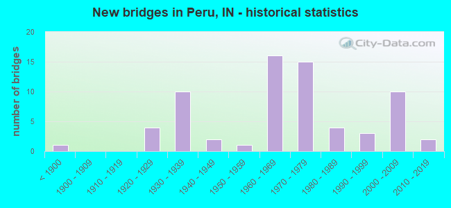
- New bridges - historical statistics
- 1Before 1900
- 41920-1929
- 101930-1939
- 21940-1949
- 11950-1959
- 161960-1969
- 151970-1979
- 41980-1989
- 31990-1999
- 102000-2009
- 22010-2019
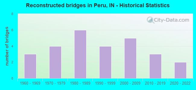
- Reconstructed bridges - Historical Statistics
- 31960-1969
- 41970-1979
- 61980-1989
- 41990-1999
- 52000-2009
- 32010-2019
- 22020-2022
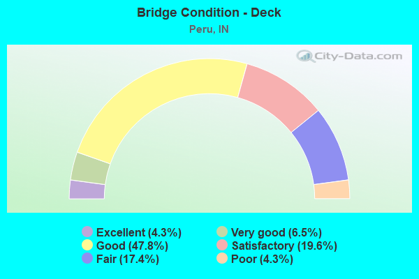
- Bridge Condition - Deck
- 4.3%Excellent
- 6.5%Very good
- 47.8%Good
- 19.6%Satisfactory
- 17.4%Fair
- 4.3%Poor
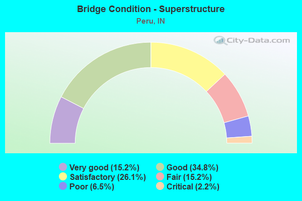
- Bridge Condition - Superstructure
- 15.2%Very good
- 34.8%Good
- 26.1%Satisfactory
- 15.2%Fair
- 6.5%Poor
- 2.2%Critical
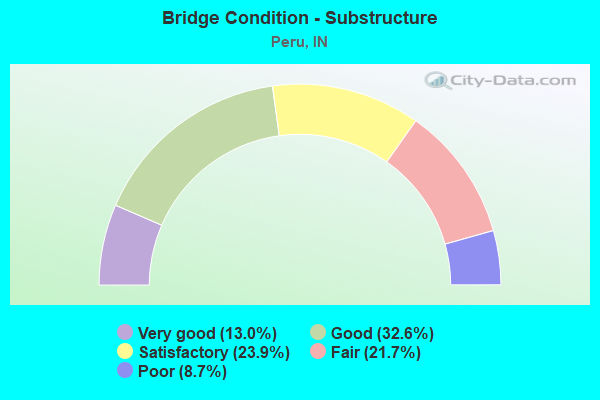
- Bridge Condition - Substructure
- 13.0%Very good
- 32.6%Good
- 23.9%Satisfactory
- 21.7%Fair
- 8.7%Poor
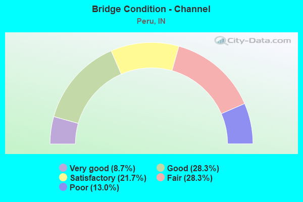
- Bridge Condition - Channel
- 8.7%Very good
- 28.3%Good
- 21.7%Satisfactory
- 28.3%Fair
- 13.0%Poor
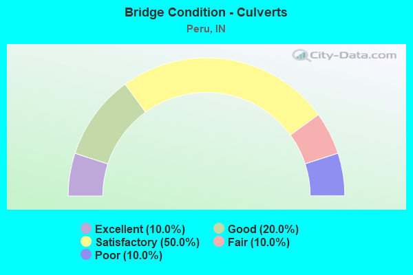
- Bridge Condition - Culverts
- 10.0%Excellent
- 20.0%Good
- 50.0%Satisfactory
- 10.0%Fair
- 10.0%Poor
Find on map >> Show street view
Structure Number: 5200088, Location: 10.00 W OF CR 550 E (Lat: 40.725061, Lng: -85.985889), Route carried "on" structure: Alternate County highway , Year Built: 1970, Status: Open, Structure Length: 6.08m (19.95ft), Average Daily Traffic: 235 (year 2011), Truck Traffic: 5%, Average Future Daily Traffic: 450 (year 2031), Features Intersected: MISSISSINEWA RIVER, Facility Carried by Structure: FRANCESSLOCUM TRL
Minimum Vertical Clearance: 30+ m (98+ ft), Kilometerpoint: 0.000, Lanes on structure: 2, Owner: County Highway Agency, Approaching Roadway Width: 7.6m (24.9ft), Material/Design: Prestressed concrete continuous, Design/Construction: Stringer/Multi-beam, Number Of Spans In Main Unit: 3, Length of Maximum Span: 20.1m (65.9ft), Curb-To-Curb Width: 9.4m (30.8ft), Out-to-Out Width: 10.2m (33.5ft)
Condition: Deck: Good, Superstructure: Good, Substructure: Good, Channel: Satisfactory, Operating Rating: 40.8 metric tons, Method Used To Determine Operating Rating: Field evaluation and documented engineering judgment, Inventory Rating: 32.7 metric tons, Method Used To Determine Inventory Rating: Field evaluation and documented engineering judgment, Structural Evaluation: Better than present minimum criteria, Deck Geometry: Equal to present minimum criteria, Waterway Adequacy: Equal to present desirable criteria, Approach Roadway Alignment: Equal to present minimum criteria, Designated Inspection Frequency: Every 24 months, Underwater Inspection Frequency: Every 48 months, Inspection Date: May 2021, Underwater Inspection Date: September 2019, Deck Structure Type: Concrete Cast-file-Place, Wearing Surface/Protective System: Wearing Surface: Monolithic Concrete
Find on map >> Show street view
Structure Number: 520012, Location: 0.40 W OF CR 1050 E (Lat: 40.594431, Lng: -85.880731), Route carried "on" structure: Alternate County highway 6, Year Built: 1930, Year Reconstructed: 1980, Status: Open, Structure Length: 1.10m (3.61ft), Average Daily Traffic: 100 (year 2011), Truck Traffic: 5%, Average Future Daily Traffic: 175 (year 2031), Features Intersected: LITTLE PIPE CREEK, Facility Carried by Structure: CR 1200 SOUTH
Minimum Vertical Clearance: 30+ m (98+ ft), Kilometerpoint: 0.000, Lanes on structure: 2, Owner: County Highway Agency, Approaching Roadway Width: 5.5m (18.0ft), Material/Design: Prestressed concrete, Design/Construction: Box Beam or Girders - Multiple, Number Of Spans In Main Unit: 1, Length of Maximum Span: 8.2m (26.9ft), Curb-To-Curb Width: 7.2m (23.6ft), Out-to-Out Width: 7.3m (24.0ft)
Condition: Deck: Satisfactory, Superstructure: Satisfactory, Substructure: Poor, Channel: Fair, Operating Rating: 40.8 metric tons, Method Used To Determine Operating Rating: Field evaluation and documented engineering judgment, Inventory Rating: 32.7 metric tons, Method Used To Determine Inventory Rating: Field evaluation and documented engineering judgment, Structural Evaluation: Meets minimum limits, Deck Geometry: Somewhat better than minimum adequacy, Waterway Adequacy: Better than present minimum criteria, Approach Roadway Alignment: Equal to present desirable criteria, Length Of Structure Improvement: 1.52m (4.99ft), Designated Inspection Frequency: Every 12 months, Inspection Date: May 2021, Bridge Improvement Cost: $250,000, Roadway Improvement Cost: $150,000, Total Project Cost: $400,000 ( Estimate for 2021), Deck Structure Type: Concrete Precast Panels, Wearing Surface/Protective System: Wearing Surface: Bituminous
Find on map >> Show street view
Structure Number: 5200122, Location: 0.20 S OF W MAIN STREET (Lat: 40.742419, Lng: -86.096550), Route carried "on" structure: City street 31, Year Built: 1939, Year Reconstructed: 1988, Status: Posted for load, Structure Length: 18.59m (60.99ft), Average Daily Traffic: 8,582 (year 2020), Truck Traffic: 10%, Average Future Daily Traffic: 15,697 (year 2040), Design Load: H 20, Features Intersected: WABASH RIVER
Minimum Vertical Clearance: 4.37m (14.34ft), Kilometerpoint: 0.000, Lanes on structure: 2, Owner: County Highway Agency, Approaching Roadway Width: 9.1m (29.9ft), Material/Design: Steel, Design/Construction: Truss - Thru, Number Of Spans In Main Unit: 3, Length of Maximum Span: 61.0m (200.1ft), Curb-To-Curb Width: 8.8m (28.9ft), Out-to-Out Width: 9.7m (31.8ft)
Condition: Deck: Satisfactory, Superstructure: Fair, Substructure: Satisfactory, Channel: Fair, Operating Rating: 27.4 metric tons, Method Used To Determine Operating Rating: Load Factor (LF), Inventory Rating: 16.4 metric tons, Method Used To Determine Inventory Rating: Load Factor (LF), Structural Evaluation: Meets minimum limits, Deck Geometry: Meets minimum limits, Waterway Adequacy: Equal to present desirable criteria, Approach Roadway Alignment: Equal to present desirable criteria, Bridge Posting: Required (Relationship of Operating Rating to Maximum Legal Load: 10.0 - 19.9% below), Designated Inspection Frequency: Every 24 months, Critical Feature Inspection Frequency: Every 24 months, Other Special Inspection Frequency: Every 24 months, Inspection Date: May 2021, Critical Feature Inspection Date: May 2021, Other Special Inspection Date: May 2020, Deck Structure Type: Concrete Cast-file-Place, Wearing Surface/Protective System: Wearing Surface: Monolithic Concrete, Deck Protection: Epoxy Coated Reinforcing
Find on map >> Show street view
Structure Number: 5200123, Location: 0.20 S OF US 24 (Lat: 40.771219, Lng: -86.080239), Route carried "on" structure: City street , Year Built: 1937, Status: Posted for load, Structure Length: 1.52m (4.99ft), Average Daily Traffic: 8,473 (year 2020), Truck Traffic: 5%, Average Future Daily Traffic: 16,946 (year 2040), Features Intersected: PRAIRIE DITCH, Facility Carried by Structure: NORTH BROADWAY
Minimum Vertical Clearance: 30+ m (98+ ft), Kilometerpoint: 0.000, Lanes on structure: 2, Owner: County Highway Agency, Approaching Roadway Width: 9.1m (29.9ft), Skew: 2 degrees, Material/Design: Concrete, Design/Construction: Culvert, Number Of Spans In Main Unit: 1, Length of Maximum Span: 15.2m (49.9ft), Curb-To-Curb Width: 12.4m (40.7ft), Out-to-Out Width: 13.0m (42.7ft)
Condition: Channel: Satisfactory, Culverts: Fair, Operating Rating: 42.3 metric tons, Method Used To Determine Operating Rating: Load and Resistance Factor (LRFR), Inventory Rating: 26.2 metric tons, Method Used To Determine Inventory Rating: Load and Resistance Factor (LRFR), Structural Evaluation: Somewhat better than minimum adequacy, Deck Geometry: Somewhat better than minimum adequacy, Waterway Adequacy: Better than present minimum criteria, Approach Roadway Alignment: Equal to present desirable criteria, Designated Inspection Frequency: Every 24 months, Inspection Date: May 2021
Find on map >> Show street view
Structure Number: 5200124, Location: 0.80 N OF CR 225 S (Lat: 40.737900, Lng: -86.099569), Route carried "on" structure: City street 31, Year Built: 1939, Status: Open, Structure Length: 1.98m (6.50ft), Average Daily Traffic: 6,793 (year 2020), Truck Traffic: 5%, Average Future Daily Traffic: 11,389 (year 2040), Design Load: H 20, Features Intersected: LITTLE PIPE CREEK
Minimum Vertical Clearance: 30+ m (98+ ft), Kilometerpoint: 0.000, Lanes on structure: 2, Owner: County Highway Agency, Approaching Roadway Width: 7.6m (24.9ft), Skew: 1 degrees, Material/Design: Concrete, Design/Construction: Culvert, Number Of Spans In Main Unit: 1, Length of Maximum Span: 19.8m (65.0ft), Curb-To-Curb Width: 9.8m (32.2ft), Out-to-Out Width: 10.8m (35.4ft)
Condition: Channel: Good, Culverts: Satisfactory, Operating Rating: 63.3 metric tons, Method Used To Determine Operating Rating: Load Factor (LF), Inventory Rating: 37.9 metric tons, Method Used To Determine Inventory Rating: Load Factor (LF), Structural Evaluation: Equal to present minimum criteria, Deck Geometry: Meets minimum limits, Waterway Adequacy: Better than present minimum criteria, Approach Roadway Alignment: Equal to present minimum criteria, Designated Inspection Frequency: Every 24 months, Inspection Date: May 2021
Find on map >> Show street view
Structure Number: 5200126, Location: 0.00 N OF CR 250 S (Lat: 40.729011, Lng: -86.127631), Route carried "on" structure: Alternate County highway 113, Year Built: 1935, Status: Posted for load, Structure Length: 0.99m (3.25ft), Average Daily Traffic: 625 (year 2011), Truck Traffic: 5%, Average Future Daily Traffic: 1,100 (year 2031), Features Intersected: RIFE CREEK, Facility Carried by Structure: CR 300 WEST
Minimum Vertical Clearance: 30+ m (98+ ft), Kilometerpoint: 0.000, Lanes on structure: 2, Owner: County Highway Agency, Approaching Roadway Width: 5.8m (19.0ft), Skew: 3 degrees, Material/Design: Concrete, Design/Construction: Stringer/Multi-beam, Number Of Spans In Main Unit: 1, Length of Maximum Span: 9.1m (29.9ft), Curb-To-Curb Width: 6.0m (19.7ft), Out-to-Out Width: 6.8m (22.3ft)
Condition: Deck: Poor, Superstructure: Poor, Substructure: Poor, Channel: Fair, Operating Rating: 20.9 metric tons, Method Used To Determine Operating Rating: Field evaluation and documented engineering judgment, Inventory Rating: 15.7 metric tons, Method Used To Determine Inventory Rating: Field evaluation and documented engineering judgment, Structural Evaluation: Meets minimum limits, Deck Geometry: High priority of replacement, Waterway Adequacy: Equal to present minimum criteria, Approach Roadway Alignment: Equal to present minimum criteria, Bridge Posting: Required (Relationship of Operating Rating to Maximum Legal Load: 30.0 - 39.9% below), Length Of Structure Improvement: 1.59m (5.22ft), Designated Inspection Frequency: Every 12 months, Inspection Date: May 2021, Bridge Improvement Cost: $350,000, Roadway Improvement Cost: $200,000, Total Project Cost: $550,000 ( Estimate for 2021), Deck Structure Type: Concrete Cast-file-Place, Wearing Surface/Protective System: Wearing Surface: Bituminous
Find on map >> Show street view
Structure Number: 5200129, Location: 0.10 W OF CR 200 W (Lat: 40.721489, Lng: -86.112469), Route carried "on" structure: Alternate County highway 172, Year Built: 1950, Year Reconstructed: 1974, Status: Open, Structure Length: 0.84m (2.76ft), Average Daily Traffic: 125 (year 2011), Truck Traffic: 5%, Average Future Daily Traffic: 200 (year 2031), Features Intersected: RIFE CREEK, Facility Carried by Structure: CR 300 SOUTH
Minimum Vertical Clearance: 30+ m (98+ ft), Kilometerpoint: 0.000, Lanes on structure: 2, Owner: County Highway Agency, Approaching Roadway Width: 5.2m (17.1ft), Skew: 4 degrees, Material/Design: Prestressed concrete, Design/Construction: Box Beam or Girders - Multiple, Number Of Spans In Main Unit: 1, Length of Maximum Span: 7.7m (25.3ft), Curb-To-Curb Width: 7.4m (24.3ft), Out-to-Out Width: 7.5m (24.6ft)
Condition: Deck: Good, Superstructure: Good, Substructure: Fair, Channel: Fair, Operating Rating: 40.8 metric tons, Method Used To Determine Operating Rating: Field evaluation and documented engineering judgment, Inventory Rating: 32.7 metric tons, Method Used To Determine Inventory Rating: Field evaluation and documented engineering judgment, Structural Evaluation: Somewhat better than minimum adequacy, Deck Geometry: Somewhat better than minimum adequacy, Waterway Adequacy: Meets minimum limits, Approach Roadway Alignment: Equal to present minimum criteria, Designated Inspection Frequency: Every 24 months, Inspection Date: May 2021, Deck Structure Type: Concrete Precast Panels, Wearing Surface/Protective System: Wearing Surface: Bituminous
Find on map >> Show street view
Structure Number: 5200136, Location: 0.00 N OF RIVERSIDE DR (Lat: 40.753611, Lng: -86.056969), Route carried "on" structure: City street , Year Built: 1974, Year Reconstructed: 1991, Status: Open, Structure Length: 16.91m (55.48ft), Average Daily Traffic: 5,000 (year 2011), Truck Traffic: 8%, Average Future Daily Traffic: 8,000 (year 2031), Design Load: HS 20, Features Intersected: WABASH RIVER, Facility Carried by Structure: WAYNE STREET
Minimum Vertical Clearance: 30+ m (98+ ft), Kilometerpoint: 0.000, Lanes on structure: 2, Owner: County Highway Agency, Approaching Roadway Width: 9.1m (29.9ft), Skew: 2 degrees, Material/Design: Prestressed concrete continuous, Design/Construction: Stringer/Multi-beam, Number Of Spans In Main Unit: 6, Length of Maximum Span: 30.5m (100.1ft), Curb or Sidewalk Widths: Left: 1.2m (3.9ft), Right: 1.2m (3.9ft), Curb-To-Curb Width: 9.1m (29.9ft), Out-to-Out Width: 12.3m (40.4ft)
Condition: Deck: Fair, Superstructure: Satisfactory, Substructure: Satisfactory, Channel: Fair, Operating Rating: 47.1 metric tons, Method Used To Determine Operating Rating: Load Factor (LF), Inventory Rating: 23.6 metric tons, Method Used To Determine Inventory Rating: Load Factor (LF), Structural Evaluation: Equal to present minimum criteria, Deck Geometry: Meets minimum limits, Waterway Adequacy: Equal to present desirable criteria, Approach Roadway Alignment: Equal to present minimum criteria, Length Of Structure Improvement: 16.92m (55.51ft), Designated Inspection Frequency: Every 24 months, Inspection Date: May 2021, Bridge Improvement Cost: $3,500,000, Roadway Improvement Cost: $250,000, Total Project Cost: $3,750,000 ( Estimate for 2021), Deck Structure Type: Concrete Cast-file-Place, Wearing Surface/Protective System: Wearing Surface: Latex Concrete
Find on map >> Show street view
Structure Number: 5200138, Location: 0.20 S OF GRAHAM ST (Lat: 40.743089, Lng: -86.060911), Route carried "on" structure: Alternate City street , Year Built: 1935, Status: Open, Structure Length: 1.07m (3.51ft), Average Daily Traffic: 235 (year 2011), Truck Traffic: 5%, Average Future Daily Traffic: 400 (year 2031), Features Intersected: SCHOOLMAN DITCH, Facility Carried by Structure: PARK DRIVE
Minimum Vertical Clearance: 30+ m (98+ ft), Kilometerpoint: 0.000, Lanes on structure: 2, Owner: County Highway Agency, Approaching Roadway Width: 6.1m (20.0ft), Material/Design: Concrete, Design/Construction: Slab, Number Of Spans In Main Unit: 2, Length of Maximum Span: 4.9m (16.1ft), Curb-To-Curb Width: 10.2m (33.5ft), Out-to-Out Width: 11.2m (36.7ft)
Condition: Deck: Poor, Superstructure: Poor, Substructure: Poor, Channel: Poor, Operating Rating: 34.6 metric tons, Method Used To Determine Operating Rating: Field evaluation and documented engineering judgment, Inventory Rating: 25.5 metric tons, Method Used To Determine Inventory Rating: Field evaluation and documented engineering judgment, Structural Evaluation: Meets minimum limits, Deck Geometry: Better than present minimum criteria, Waterway Adequacy: Somewhat better than minimum adequacy, Approach Roadway Alignment: Equal to present minimum criteria, Length Of Structure Improvement: 1.22m (4.00ft), Designated Inspection Frequency: Every 12 months, Inspection Date: May 2021, Bridge Improvement Cost: $300,000, Roadway Improvement Cost: $100,000, Total Project Cost: $400,000 ( Estimate for 2021), Deck Structure Type: Concrete Cast-file-Place, Wearing Surface/Protective System: Wearing Surface: Bituminous
Find on map >> Show street view
Structure Number: 5200143, Location: 0.60 N OF WABASH ROAD (Lat: 40.777161, Lng: -86.027889), Route carried "on" structure: Alternate County highway , Year Built: 2003, Status: Posted for load, Structure Length: 1.22m (4.00ft), Average Daily Traffic: 110 (year 2011), Truck Traffic: 5%, Average Future Daily Traffic: 200 (year 2031), Design Load: H 20, Features Intersected: COUNTRY CLUB CREEK, Facility Carried by Structure: COUNTRY CLUB ROAD
Minimum Vertical Clearance: 30+ m (98+ ft), Kilometerpoint: 0.000, Lanes on structure: 2, Owner: County Highway Agency, Approaching Roadway Width: 7.3m (24.0ft), Skew: 4 degrees, Material/Design: Steel, Design/Construction: Stringer/Multi-beam, Number Of Spans In Main Unit: 1, Length of Maximum Span: 10.9m (35.8ft), Curb-To-Curb Width: 7.3m (24.0ft), Out-to-Out Width: 7.3m (24.0ft)
Condition: Deck: Satisfactory, Superstructure: Satisfactory, Substructure: Good, Channel: Good, Operating Rating: 42.9 metric tons, Method Used To Determine Operating Rating: Load Factor (LF), Inventory Rating: 25.7 metric tons, Method Used To Determine Inventory Rating: Load Factor (LF), Structural Evaluation: Equal to present minimum criteria, Deck Geometry: Somewhat better than minimum adequacy, Waterway Adequacy: Equal to present desirable criteria, Approach Roadway Alignment: Equal to present minimum criteria, Designated Inspection Frequency: Every 24 months, Inspection Date: May 2021, Deck Structure Type: Open Grating, Wearing Surface/Protective System: Wearing Surface: Other
Find on map >> Show street view
Structure Number: 5200149, Location: 0.40 NW OF US 31 (Lat: 40.753250, Lng: -86.136339), Route carried "on" structure: Alternate County highway , Year Built: 1928, Year Reconstructed: 1968, Status: Open, Structure Length: 1.59m (5.22ft), Average Daily Traffic: 2,800 (year 2020), Truck Traffic: 5%, Average Future Daily Traffic: 4,480 (year 2040), Features Intersected: PRAIRIE DITCH, Facility Carried by Structure: LOGANSPORT ROAD
Minimum Vertical Clearance: 30+ m (98+ ft), Kilometerpoint: 0.000, Lanes on structure: 2, Owner: County Highway Agency, Approaching Roadway Width: 8.5m (27.9ft), Material/Design: Concrete, Design/Construction: Culvert, Number Of Spans In Main Unit: 1, Length of Maximum Span: 15.9m (52.2ft), Curb-To-Curb Width: 13.3m (43.6ft), Out-to-Out Width: 14.1m (46.3ft)
Condition: Channel: Good, Culverts: Satisfactory, Operating Rating: 40.8 metric tons, Method Used To Determine Operating Rating: Field evaluation and documented engineering judgment, Inventory Rating: 32.7 metric tons, Method Used To Determine Inventory Rating: Field evaluation and documented engineering judgment, Structural Evaluation: Equal to present minimum criteria, Deck Geometry: Equal to present minimum criteria, Waterway Adequacy: Better than present minimum criteria, Approach Roadway Alignment: Equal to present desirable criteria, Designated Inspection Frequency: Every 24 months, Inspection Date: May 2021
Find on map >> Show street view
Structure Number: 5200153, Location: 1.20 S OF CR 250 N (Lat: 40.785481, Lng: -86.029819), Route carried "on" structure: Alternate County highway , Year Built: 2001, Status: Open, Structure Length: 0.67m (2.20ft), Average Daily Traffic: 110 (year 2011), Truck Traffic: 5%, Average Future Daily Traffic: 200 (year 2031), Features Intersected: COUNTRY CLUB CREEK, Facility Carried by Structure: COUNTRY CLUB ROAD
Minimum Vertical Clearance: 30+ m (98+ ft), Kilometerpoint: 0.000, Lanes on structure: 2, Owner: County Highway Agency, Approaching Roadway Width: 6.1m (20.0ft), Material/Design: Concrete, Design/Construction: Culvert, Number Of Spans In Main Unit: 2, Length of Maximum Span: 3.0m (9.8ft), Curb or Sidewalk Widths: Left: 0.3m (1.0ft), Right: 0.3m (1.0ft), Curb-To-Curb Width: 8.8m (28.9ft), Out-to-Out Width: 8.8m (28.9ft)
Condition: Channel: Fair, Culverts: Satisfactory, Operating Rating: 40.8 metric tons, Method Used To Determine Operating Rating: Field evaluation and documented engineering judgment, Inventory Rating: 32.7 metric tons, Method Used To Determine Inventory Rating: Field evaluation and documented engineering judgment, Structural Evaluation: Equal to present minimum criteria, Deck Geometry: Equal to present minimum criteria, Waterway Adequacy: Somewhat better than minimum adequacy, Approach Roadway Alignment: Equal to present minimum criteria, Designated Inspection Frequency: Every 24 months, Inspection Date: May 2021
Find on map >> Show street view
Structure Number: 5200154, Location: 0.40 S OF CR 250 N (Lat: 40.795589, Lng: -86.026700), Route carried "on" structure: Alternate County highway , Year Built: 2001, Status: Open, Structure Length: 0.76m (2.49ft), Average Daily Traffic: 110 (year 2011), Truck Traffic: 5%, Average Future Daily Traffic: 200 (year 2031), Features Intersected: COUNTRY CLUB CREEK, Facility Carried by Structure: COUNTRY CLUB ROAD
Minimum Vertical Clearance: 30+ m (98+ ft), Kilometerpoint: 0.000, Lanes on structure: 2, Owner: County Highway Agency, Approaching Roadway Width: 6.4m (21.0ft), Material/Design: Aluminum, Iron, Design/Construction: Culvert, Number Of Spans In Main Unit: 1, Length of Maximum Span: 7.6m (24.9ft), Curb-To-Curb Width: 9.2m (30.2ft), Out-to-Out Width: 9.6m (31.5ft)
Condition: Channel: Satisfactory, Culverts: Good, Inventory Rating: 60.0 metric tons, Method Used To Determine Inventory Rating: Load Factor (LF), Structural Evaluation: Better than present minimum criteria, Deck Geometry: Equal to present minimum criteria, Waterway Adequacy: Better than present minimum criteria, Approach Roadway Alignment: Equal to present minimum criteria, Designated Inspection Frequency: Every 24 months, Inspection Date: May 2021
Find on map >> Show street view
Structure Number: 5200155, Location: 0.80 S OF CR 250 N (Lat: 40.791061, Lng: -86.030261), Route carried "on" structure: Alternate County highway , Year Built: 2001, Status: Open, Structure Length: 0.67m (2.20ft), Average Daily Traffic: 110 (year 2011), Truck Traffic: 5%, Average Future Daily Traffic: 200 (year 2031), Features Intersected: COUNTRY CLUB CREEK, Facility Carried by Structure: COUNTRY CLUB ROAD
Minimum Vertical Clearance: 30+ m (98+ ft), Kilometerpoint: 0.000, Lanes on structure: 2, Owner: County Highway Agency, Approaching Roadway Width: 6.4m (21.0ft), Material/Design: Concrete, Design/Construction: Culvert, Number Of Spans In Main Unit: 2, Length of Maximum Span: 3.0m (9.8ft), Curb or Sidewalk Widths: Left: 0.4m (1.3ft), Right: 0.4m (1.3ft), Curb-To-Curb Width: 9.8m (32.2ft), Out-to-Out Width: 10.5m (34.4ft)
Condition: Channel: Fair, Culverts: Satisfactory, Operating Rating: 40.8 metric tons, Method Used To Determine Operating Rating: Field evaluation and documented engineering judgment, Inventory Rating: 32.7 metric tons, Method Used To Determine Inventory Rating: Field evaluation and documented engineering judgment, Structural Evaluation: Equal to present minimum criteria, Deck Geometry: Better than present minimum criteria, Waterway Adequacy: Equal to present minimum criteria, Approach Roadway Alignment: Equal to present desirable criteria, Designated Inspection Frequency: Every 24 months, Inspection Date: May 2021
Find on map >> Show street view
Structure Number: 5200164, Location: 0.00 N OF PAW PAW PARK (Lat: 40.768189, Lng: -86.026911), Route carried "on" structure: Alternate County highway , Year Built: 1935, Status: Posted for load, Structure Length: 0.62m (2.03ft), Average Daily Traffic: 100 (year 2011), Truck Traffic: 5%, Average Future Daily Traffic: 150 (year 2031), Features Intersected: COUNTRY CLUB CREEK, Facility Carried by Structure: COUNTRY CLUB ROAD
Minimum Vertical Clearance: 30+ m (98+ ft), Kilometerpoint: 0.000, Lanes on structure: 2, Owner: County Highway Agency, Approaching Roadway Width: 4.3m (14.1ft), Material/Design: Concrete, Design/Construction: Culvert, Number Of Spans In Main Unit: 1, Length of Maximum Span: 6.2m (20.3ft), Curb-To-Curb Width: 6.6m (21.7ft), Out-to-Out Width: 7.2m (23.6ft)
Condition: Channel: Poor, Culverts: Poor, Operating Rating: 8.2 metric tons, Method Used To Determine Operating Rating: Field evaluation and documented engineering judgment, Inventory Rating: 4.9 metric tons, Method Used To Determine Inventory Rating: Field evaluation and documented engineering judgment, Structural Evaluation: High priority of replacement, Deck Geometry: Somewhat better than minimum adequacy, Waterway Adequacy: Somewhat better than minimum adequacy, Approach Roadway Alignment: High priority of corrective action, Bridge Posting: Required (Relationship of Operating Rating to Maximum Legal Load: > 39.9% below), Length Of Structure Improvement: 0.91m (2.99ft), Designated Inspection Frequency: Every 12 months, Inspection Date: May 2021, Bridge Improvement Cost: $200,000, Roadway Improvement Cost: $200,000, Total Project Cost: $400,000 ( Estimate for 2021)
Find on map >> Show street view
Structure Number: 520017, Location: 0.20 E OF CR 450 E (Lat: 40.770911, Lng: -85.984511), Route carried "on" structure: Alternate County highway , Year Built: 2015, Status: Open, Structure Length: 0.96m (3.15ft), Average Daily Traffic: 100 (year 2011), Truck Traffic: 5%, Average Future Daily Traffic: 175 (year 2031), Features Intersected: DANIEL CREEK, Facility Carried by Structure: DANIELS ROAD
Minimum Vertical Clearance: 30+ m (98+ ft), Kilometerpoint: 0.000, Lanes on structure: 2, Owner: County Highway Agency, Approaching Roadway Width: 6.7m (22.0ft), Skew: 3 degrees, Material/Design: Prestressed concrete, Design/Construction: Box Beam or Girders - Multiple, Number Of Spans In Main Unit: 1, Length of Maximum Span: 8.0m (26.2ft), Curb-To-Curb Width: 7.2m (23.6ft), Out-to-Out Width: 7.3m (24.0ft)
Condition: Deck: Very good, Superstructure: Very good, Substructure: Very good, Channel: Very good, Operating Rating: 40.8 metric tons, Method Used To Determine Operating Rating: Field evaluation and documented engineering judgment, Inventory Rating: 32.7 metric tons, Method Used To Determine Inventory Rating: Field evaluation and documented engineering judgment, Structural Evaluation: Equal to present desirable criteria, Deck Geometry: Somewhat better than minimum adequacy, Waterway Adequacy: Equal to present desirable criteria, Approach Roadway Alignment: Equal to present minimum criteria, Designated Inspection Frequency: Every 24 months, Inspection Date: May 2021, Deck Structure Type: Concrete Precast Panels, Wearing Surface/Protective System: Wearing Surface: Bituminous
Find on map >> Show street view
Structure Number: 5200171, Location: 0.65 W OF SR 19 (Lat: 40.745019, Lng: -86.076900), Route carried "on" structure: City street , Year Built: 2018, Status: Open, Structure Length: 1.50m (4.92ft), Average Daily Traffic: 1,908 (year 2020), Truck Traffic: 5%, Average Future Daily Traffic: 3,201 (year 2040), Design Load: HS 20, Features Intersected: STREAM 2 WABASH RIVER, Facility Carried by Structure: WEST RIVERSIDE DR
Minimum Vertical Clearance: 30+ m (98+ ft), Kilometerpoint: 0.000, Lanes on structure: 2, Owner: County Highway Agency, Approaching Roadway Width: 6.9m (22.6ft), Material/Design: Prestressed concrete, Design/Construction: Box Beam or Girders - Multiple, Number Of Spans In Main Unit: 1, Length of Maximum Span: 14.2m (46.6ft), Curb-To-Curb Width: 7.3m (24.0ft), Out-to-Out Width: 7.4m (24.3ft)
Condition: Deck: Very good, Superstructure: Very good, Substructure: Very good, Channel: Good, Operating Rating: 53.9 metric tons, Method Used To Determine Operating Rating: Load and Resistance Factor (LRFR), Inventory Rating: 40.1 metric tons, Method Used To Determine Inventory Rating: Load and Resistance Factor (LRFR), Structural Evaluation: Equal to present desirable criteria, Deck Geometry: Meets minimum limits, Waterway Adequacy: Equal to present minimum criteria, Approach Roadway Alignment: Equal to present minimum criteria, Designated Inspection Frequency: Every 24 months, Inspection Date: May 2021, Deck Structure Type: Concrete Precast Panels
Find on map >> Show street view
Structure Number: 6019, Location: 03.79 W SR 19 (Lat: 40.771939, Lng: -86.128289), Route carried "under" structure: US 31, Year Built: 2000, Structure Length: 0. m, Average Daily Traffic: 7,599 (year 2020), Truck Traffic: 25%, Features Intersected: US 31 NB, Facility Carried by Structure: US 24 EB
Minimum Vertical Clearance: 5.59m (18.34ft), Kilometerpoint: 23.142, Lanes on structure: 3, Lanes under structure: 6, Material/Design: Steel continuous, Design/Construction: Stringer/Multi-beam, Length of Maximum Span: 40.8m (133.9ft)
Find on map >> Show street view
Structure Number: 6019, Location: 03.79 W SR 19 (Lat: 40.771939, Lng: -86.128289), Route carried "under" structure: US 31, Year Built: 2000, Structure Length: 0. m, Average Daily Traffic: 8,558 (year 2020), Truck Traffic: 25%, Features Intersected: US 31 SB, Facility Carried by Structure: US 24 EB
Minimum Vertical Clearance: 5.59m (18.34ft), Kilometerpoint: 23.142, Lanes on structure: 3, Lanes under structure: 6, Material/Design: Steel continuous, Design/Construction: Stringer/Multi-beam, Length of Maximum Span: 40.8m (133.9ft)
Find on map >> Show street view
Structure Number: 6021, Location: 03.79 W SR-19 (Lat: 40.772211, Lng: -86.128325), Route carried "under" structure: US 31, Year Built: 1976, Structure Length: 0. m, Average Daily Traffic: 7,599 (year 2020), Truck Traffic: 25%, Features Intersected: US 31 NB, Facility Carried by Structure: US 24 WB
Minimum Vertical Clearance: 5.59m (18.34ft), Kilometerpoint: 23.158, Lanes on structure: 3, Lanes under structure: 6, Material/Design: Steel continuous, Design/Construction: Stringer/Multi-beam, Length of Maximum Span: 38.1m (125.0ft)
Find on map >> Show street view
Structure Number: 6021, Location: 03.79 W SR-19 (Lat: 40.772211, Lng: -86.128325), Route carried "under" structure: US 31, Year Built: 1976, Structure Length: 0. m, Average Daily Traffic: 8,558 (year 2020), Truck Traffic: 25%, Features Intersected: US 31 SB, Facility Carried by Structure: US 24 WB
Minimum Vertical Clearance: 5.59m (18.34ft), Kilometerpoint: 23.158, Lanes on structure: 3, Lanes under structure: 6, Material/Design: Steel continuous, Design/Construction: Stringer/Multi-beam, Length of Maximum Span: 38.1m (125.0ft)
Find on map >> Show street view
Structure Number: 6028, Location: 00.61 W SR-19 (Lat: 40.774519, Lng: -86.068078), Route carried "under" structure: County highway , Year Built: 1975, Structure Length: 0. m, Average Daily Traffic: 283 (year 2018), Truck Traffic: 2%, Features Intersected: DENVER PIKE, Facility Carried by Structure: US 24 EB
Minimum Vertical Clearance: 6.53m (21.42ft), Kilometerpoint: 0.000, Lanes on structure: 2, Lanes under structure: 2, Material/Design: Steel continuous, Design/Construction: Stringer/Multi-beam, Length of Maximum Span: 25.5m (83.7ft)
Find on map >> Show street view
Structure Number: 6029, Location: 00.61 W SR-19 (Lat: 40.774781, Lng: -86.068078), Route carried "under" structure: County highway , Year Built: 1975, Structure Length: 0. m, Average Daily Traffic: 283 (year 2018), Truck Traffic: 2%, Features Intersected: DENVER PIKE, Facility Carried by Structure: US 24 WB
Minimum Vertical Clearance: 5.72m (18.77ft), Kilometerpoint: 0.000, Lanes on structure: 2, Lanes under structure: 2, Material/Design: Steel continuous, Design/Construction: Stringer/Multi-beam, Length of Maximum Span: 25.5m (83.7ft)
Find on map >> Show street view
Structure Number: 988, Location: 00.15 S US 24 (Lat: 40.747339, Lng: -86.127511), Route carried "under" structure: County highway , Year Built: 1963, Structure Length: 0. m, Average Daily Traffic: 885 (year 2018), Truck Traffic: 3%, Features Intersected: River Road, Facility Carried by Structure: US 31 NB
Minimum Vertical Clearance: 4.42m (14.50ft), Kilometerpoint: 0.000, Lanes on structure: 2, Lanes under structure: 4, Material/Design: Steel continuous, Design/Construction: Girder and Floorbeam System, Length of Maximum Span: 37.4m (122.7ft)
Find on map >> Show street view
Structure Number: 988, Location: 00.15 S US 24 (Lat: 40.747339, Lng: -86.127511), Route carried "under" structure: County highway , Year Built: 1963, Structure Length: 0. m, Average Daily Traffic: 132 (year 2004), Truck Traffic: 15%, Features Intersected: Old Stone Road, Facility Carried by Structure: US 31 NB
Minimum Vertical Clearance: 4.42m (14.50ft), Kilometerpoint: 0.000, Lanes on structure: 2, Lanes under structure: 4, Material/Design: Steel continuous, Design/Construction: Girder and Floorbeam System, Length of Maximum Span: 37.4m (122.7ft)
Find on map >> Show street view
Structure Number: 989, Location: 00.15 S US 24 (Lat: 40.747319, Lng: -86.127792), Route carried "under" structure: County highway , Year Built: 1963, Structure Length: 0. m, Average Daily Traffic: 885 (year 2018), Truck Traffic: 1%, Features Intersected: River Road, Facility Carried by Structure: US 31 SB
Minimum Vertical Clearance: 4.42m (14.50ft), Kilometerpoint: 0.000, Lanes on structure: 2, Lanes under structure: 4, Material/Design: Steel continuous, Design/Construction: Girder and Floorbeam System, Length of Maximum Span: 37.4m (122.7ft)
Find on map >> Show street view
Structure Number: 989, Location: 00.15 S US 24 (Lat: 40.747319, Lng: -86.127792), Route carried "under" structure: County highway , Year Built: 1963, Structure Length: 0. m, Average Daily Traffic: 132 (year 2004), Truck Traffic: 15%, Features Intersected: Old Stone Road, Facility Carried by Structure: US 31 SB
Minimum Vertical Clearance: 4.42m (14.50ft), Kilometerpoint: 0.000, Lanes on structure: 2, Lanes under structure: 4, Material/Design: Steel continuous, Design/Construction: Girder and Floorbeam System, Length of Maximum Span: 37.4m (122.7ft)
Find on map >> Show street view
Structure Number: 99, Location: 01.47 S US 24 (Lat: 40.751800, Lng: -86.127511), Route carried "under" structure: County highway , Year Built: 1963, Structure Length: 0. m, Average Daily Traffic: 3,400 (year 2018), Truck Traffic: 4%, Features Intersected: OLD US 24, NS RR, Facility Carried by Structure: US 31 NB
Minimum Vertical Clearance: 6.83m (22.41ft), Kilometerpoint: 0.000, Lanes on structure: 2, Lanes under structure: 2, Material/Design: Steel continuous, Design/Construction: Stringer/Multi-beam, Length of Maximum Span: 21.3m (69.9ft)
Find on map >> Show street view
Structure Number: 991, Location: 01.47 S US-24 (Lat: 40.751789, Lng: -86.127800), Route carried "under" structure: County highway , Year Built: 1963, Structure Length: 0. m, Average Daily Traffic: 2,961 (year 2017), Truck Traffic: 9%, Features Intersected: OLD US 24, NS RR, Facility Carried by Structure: US 31 SB
Minimum Vertical Clearance: 7.06m (23.16ft), Kilometerpoint: 0.000, Lanes on structure: 2, Lanes under structure: 2, Material/Design: Steel continuous, Design/Construction: Stringer/Multi-beam, Length of Maximum Span: 21.3m (69.9ft)