Bridge Statistics for Philadelphia, Mississippi (MS)
Condition, Traffic, Stress, Structural Evaluation, Project Costs
- National Bridge Inventory (NBI) Statistics
- 49Number of bridges
- 630ft / 192mTotal length
- $2,408,532,000Total costs
- 188,280Total average daily traffic
- 18,779Total average daily truck traffic
- National Bridge Inventory (NBI) Registered Bridges for Philadelphia
- No street view available for this location
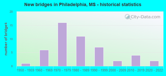
- New bridges - historical statistics
- 11950-1959
- 61960-1969
- 161970-1979
- 111980-1989
- 71990-1999
- 22000-2009
- 42010-2019
- 22020-2022


- Bridge Condition - Deck
- 21.4%Very good
- 42.9%Good
- 17.9%Satisfactory
- 17.9%Fair

- Bridge Condition - Superstructure
- 60.7%Very good
- 14.3%Good
- 10.7%Satisfactory
- 14.3%Fair

- Bridge Condition - Substructure
- 35.7%Very good
- 35.7%Good
- 7.1%Satisfactory
- 14.3%Fair
- 7.1%Poor

- Bridge Condition - Channel
- 2.2%Excellent
- 55.6%Very good
- 15.6%Good
- 15.6%Satisfactory
- 11.1%Fair

- Bridge Condition - Culverts
- 47.4%Very good
- 42.1%Good
- 5.3%Satisfactory
- 5.3%Fair
Find on map >> Show street view
Structure Number: 31000150501619, Location: 1.0 MI S SR 485 (Lat: 32.713378, Lng: -89.149842), Route carried "on" structure: State highway 15, Year Built: 1965, Status: Open, Structure Length: 7.32m (24.02ft), Average Daily Traffic: 5,200 (year 2020), Truck Traffic: 14%, Average Future Daily Traffic: 5,200 (year 2040), Design Load: HS 20, Features Intersected: COON SHUCK CREEK
Minimum Vertical Clearance: 30+ m (98+ ft), Kilometerpoint: 16.346, Lanes on structure: 2, Base Highway Network: Yes (Inventory Route: 1, Subroute: 1), Owner: State Highway Agency, Approaching Roadway Width: 12.2m (40.0ft), Material/Design: Concrete, Design/Construction: Slab, Number Of Spans In Main Unit: 12, Length of Maximum Span: 6.1m (20.0ft), Curb or Sidewalk Widths: Left: 0.5m (1.6ft), Right: 0.5m (1.6ft), Curb-To-Curb Width: 8.5m (27.9ft), Out-to-Out Width: 9.7m (31.8ft)
Condition: Deck: Fair, Superstructure: Fair, Substructure: Very good, Channel: Fair, Operating Rating: 64.3 metric tons, Method Used To Determine Operating Rating: Load Factor (LF), Inventory Rating: 38.5 metric tons, Method Used To Determine Inventory Rating: Load Factor (LF), Structural Evaluation: Somewhat better than minimum adequacy, Deck Geometry: Meets minimum limits, Waterway Adequacy: Equal to present desirable criteria, Approach Roadway Alignment: Equal to present desirable criteria, Designated Inspection Frequency: Every 24 months, Inspection Date: September 2021, Deck Structure Type: Concrete Cast-file-Place
Find on map >> Show street view
Structure Number: 31000150501656A, Location: 0.8 MI N SR 21 WEST (Lat: 32.765386, Lng: -89.139519), Route carried "on" structure: State highway 15, Year Built: 1976, Status: Open, Structure Length: 9.81m (32.19ft), Average Daily Traffic: 10,500 (year 2020), Truck Traffic: 6%, Average Future Daily Traffic: 10,500 (year 2040), Design Load: HS 20, Features Intersected: KENTAWKA CANAL
Minimum Vertical Clearance: 30+ m (98+ ft), Kilometerpoint: 0.959, Lanes on structure: 2, Owner: State Highway Agency, Approaching Roadway Width: 13.4m (44.0ft), Skew: 2 degrees, Material/Design: Prestressed concrete, Design/Construction: Stringer/Multi-beam, Number Of Spans In Main Unit: 1, Number Of Approach Spans: 6, Length of Maximum Span: 24.4m (80.1ft), Curb-To-Curb Width: 11.7m (38.4ft), Out-to-Out Width: 12.6m (41.3ft)
Condition: Deck: Good, Superstructure: Very good, Substructure: Very good, Channel: Very good, Operating Rating: 61.1 metric tons, Method Used To Determine Operating Rating: Load Factor (LF), Inventory Rating: 34.7 metric tons, Method Used To Determine Inventory Rating: Load Factor (LF), Structural Evaluation: Equal to present desirable criteria, Deck Geometry: Better than present minimum criteria, Waterway Adequacy: Equal to present desirable criteria, Approach Roadway Alignment: Equal to present desirable criteria, Designated Inspection Frequency: Every 24 months, Inspection Date: September 2021, Deck Structure Type: Concrete Cast-file-Place
Find on map >> Show street view
Structure Number: 31000150501656B, Location: 0.8 MI N SR 21 WEST (Lat: 32.764614, Lng: -89.140153), Route carried "on" structure: State highway 15, Year Built: 1976, Status: Open, Structure Length: 9.81m (32.19ft), Average Daily Traffic: 10,500 (year 2020), Truck Traffic: 6%, Average Future Daily Traffic: 10,500 (year 2040), Design Load: HS 20, Features Intersected: KENTAWKA CANAL
Minimum Vertical Clearance: 30+ m (98+ ft), Kilometerpoint: 22.553, Lanes on structure: 3, Owner: State Highway Agency, Approaching Roadway Width: 17.1m (56.1ft), Skew: 2 degrees, Material/Design: Prestressed concrete, Design/Construction: Stringer/Multi-beam, Number Of Spans In Main Unit: 1, Number Of Approach Spans: 6, Length of Maximum Span: 24.4m (80.1ft), Curb-To-Curb Width: 15.4m (50.5ft), Out-to-Out Width: 16.2m (53.1ft)
Condition: Deck: Satisfactory, Superstructure: Very good, Substructure: Good, Channel: Very good, Operating Rating: 57.7 metric tons, Method Used To Determine Operating Rating: Load Factor (LF), Inventory Rating: 29.8 metric tons, Method Used To Determine Inventory Rating: Load Factor (LF), Structural Evaluation: Better than present minimum criteria, Deck Geometry: Equal to present minimum criteria, Waterway Adequacy: Equal to present desirable criteria, Approach Roadway Alignment: Equal to present desirable criteria, Designated Inspection Frequency: Every 24 months, Inspection Date: September 2021, Deck Structure Type: Concrete Cast-file-Place
Find on map >> Show street view
Structure Number: 31000150501659A, Location: 0.1 MI N SR 16 EAST (Lat: 32.768858, Lng: -89.136644), Route carried "on" structure: State highway 15, Year Built: 1975, Status: Open, Structure Length: 6.16m (20.21ft), Average Daily Traffic: 10,500 (year 2020), Truck Traffic: 6%, Average Future Daily Traffic: 10,500 (year 2040), Design Load: HS 20, Features Intersected: RELIEF FOR CANAL
Minimum Vertical Clearance: 30+ m (98+ ft), Kilometerpoint: 0.486, Lanes on structure: 2, Owner: State Highway Agency, Approaching Roadway Width: 13.4m (44.0ft), Material/Design: Prestressed concrete continuous, Design/Construction: Stringer/Multi-beam, Number Of Spans In Main Unit: 5, Length of Maximum Span: 12.2m (40.0ft), Curb-To-Curb Width: 11.7m (38.4ft), Out-to-Out Width: 12.7m (41.7ft)
Condition: Deck: Very good, Superstructure: Very good, Substructure: Good, Channel: Very good, Operating Rating: 66.8 metric tons, Method Used To Determine Operating Rating: Load Factor (LF), Inventory Rating: 35.8 metric tons, Method Used To Determine Inventory Rating: Load Factor (LF), Structural Evaluation: Better than present minimum criteria, Deck Geometry: Better than present minimum criteria, Waterway Adequacy: Equal to present desirable criteria, Approach Roadway Alignment: Equal to present desirable criteria, Designated Inspection Frequency: Every 24 months, Underwater Inspection Frequency: Every 60 months, Inspection Date: September 2021, Underwater Inspection Date: November 2019, Deck Structure Type: Concrete Cast-file-Place
Find on map >> Show street view
Structure Number: 31000150501659B, Location: 0.1 MI N SR 16 EAST (Lat: 32.768275, Lng: -89.136681), Route carried "on" structure: State highway 15, Year Built: 1975, Status: Open, Structure Length: 6.16m (20.21ft), Average Daily Traffic: 10,500 (year 2020), Truck Traffic: 6%, Average Future Daily Traffic: 10,500 (year 2040), Design Load: HS 20, Features Intersected: RELIEF FOR CANAL
Minimum Vertical Clearance: 30+ m (98+ ft), Kilometerpoint: 23.076, Lanes on structure: 2, Owner: State Highway Agency, Approaching Roadway Width: 13.4m (44.0ft), Material/Design: Prestressed concrete, Design/Construction: Stringer/Multi-beam, Number Of Spans In Main Unit: 5, Length of Maximum Span: 12.2m (40.0ft), Curb-To-Curb Width: 11.7m (38.4ft), Out-to-Out Width: 12.7m (41.7ft)
Condition: Deck: Good, Superstructure: Very good, Substructure: Good, Channel: Very good, Operating Rating: 59.7 metric tons, Method Used To Determine Operating Rating: Load Factor (LF), Inventory Rating: 34.3 metric tons, Method Used To Determine Inventory Rating: Load Factor (LF), Structural Evaluation: Better than present minimum criteria, Deck Geometry: Better than present minimum criteria, Waterway Adequacy: Equal to present desirable criteria, Approach Roadway Alignment: Equal to present desirable criteria, Designated Inspection Frequency: Every 24 months, Underwater Inspection Frequency: Every 60 months, Inspection Date: September 2021, Underwater Inspection Date: November 2019, Deck Structure Type: Concrete Cast-file-Place
Find on map >> Show street view
Structure Number: 31000150501693, Location: SR15 OVER SR 19 (Lat: 32.809303, Lng: -89.119261), Route carried "on" structure: State highway 15, Year Built: 1975, Status: Open, Structure Length: 10.12m (33.20ft), Average Daily Traffic: 5,300 (year 2020), Truck Traffic: 16%, Average Future Daily Traffic: 5,300 (year 2040), Design Load: HS 20, Features Intersected: SR 19
Minimum Vertical Clearance: 30+ m (98+ ft), Kilometerpoint: 28.435, Lanes on structure: 2, Lanes under structure: 4, Owner: State Highway Agency, Approaching Roadway Width: 13.4m (44.0ft), Skew: 2 degrees, Material/Design: Prestressed concrete, Design/Construction: Stringer/Multi-beam, Number Of Spans In Main Unit: 2, Number Of Approach Spans: 2, Length of Maximum Span: 29.0m (95.1ft), Curb-To-Curb Width: 15.4m (50.5ft), Out-to-Out Width: 16.4m (53.8ft)
Condition: Deck: Satisfactory, Superstructure: Good, Substructure: Fair, Operating Rating: 57.1 metric tons, Method Used To Determine Operating Rating: Load Factor (LF), Inventory Rating: 29.0 metric tons, Method Used To Determine Inventory Rating: Load Factor (LF), Structural Evaluation: Somewhat better than minimum adequacy, Deck Geometry: Superior to present desirable criteria, Underclear: Better than present minimum criteria, Approach Roadway Alignment: Equal to present desirable criteria, Designated Inspection Frequency: Every 24 months, Inspection Date: October 2021, Deck Structure Type: Concrete Cast-file-Place
Find on map >> Show street view
Structure Number: 31000150501695, Location: 0.2 MI N SR 19 (Lat: 32.809358, Lng: -89.117228), Route carried "on" structure: State highway 15, Year Built: 1975, Status: Open, Structure Length: 0.82m (2.69ft), Average Daily Traffic: 5,300 (year 2020), Truck Traffic: 16%, Average Future Daily Traffic: 5,300 (year 2040), Design Load: HS 20+Mod, Features Intersected: WATKINS CREEK
Minimum Vertical Clearance: 30+ m (98+ ft), Kilometerpoint: 28.627, Lanes on structure: 2, Owner: State Highway Agency, Approaching Roadway Width: 13.4m (44.0ft), Material/Design: Concrete, Design/Construction: Culvert, Number Of Spans In Main Unit: 2, Length of Maximum Span: 3.7m (12.1ft)
Condition: Channel: Very good, Culverts: Very good, Structural Evaluation: Equal to present desirable criteria, Waterway Adequacy: Equal to present desirable criteria, Approach Roadway Alignment: Equal to present desirable criteria, Designated Inspection Frequency: Every 24 months, Inspection Date: October 2021
Find on map >> Show street view
Structure Number: 31000150501696, Location: 0.3 MI N SR 19 (Lat: 32.809403, Lng: -89.115508), Route carried "on" structure: State highway 15, Year Built: 1975, Status: Open, Structure Length: 4.79m (15.72ft), Average Daily Traffic: 5,300 (year 2020), Truck Traffic: 16%, Average Future Daily Traffic: 5,300 (year 2040), Design Load: HS 20, Features Intersected: KCS RR
Minimum Vertical Clearance: 30+ m (98+ ft), Kilometerpoint: 28.788, Lanes on structure: 2, Owner: State Highway Agency, Approaching Roadway Width: 13.4m (44.0ft), Skew: 1 degrees, Material/Design: Prestressed concrete, Design/Construction: Stringer/Multi-beam, Number Of Spans In Main Unit: 1, Number Of Approach Spans: 2, Length of Maximum Span: 16.8m (55.1ft), Curb-To-Curb Width: 12.3m (40.4ft), Out-to-Out Width: 13.4m (44.0ft)
Condition: Deck: Satisfactory, Superstructure: Very good, Substructure: Fair, Operating Rating: 60.2 metric tons, Method Used To Determine Operating Rating: Load Factor (LF), Inventory Rating: 32.2 metric tons, Method Used To Determine Inventory Rating: Load Factor (LF), Structural Evaluation: Somewhat better than minimum adequacy, Deck Geometry: Somewhat better than minimum adequacy, Underclear: Better than present minimum criteria, Approach Roadway Alignment: Equal to present desirable criteria, Designated Inspection Frequency: Every 24 months, Inspection Date: October 2021, Deck Structure Type: Concrete Cast-file-Place
Find on map >> Show street view
Structure Number: 31000150501705, Location: 0.9 MI N SR 19 (Lat: 32.816458, Lng: -89.103017), Route carried "on" structure: State highway 15, Year Built: 1975, Status: Open, Structure Length: 0.79m (2.59ft), Average Daily Traffic: 4,600 (year 2020), Truck Traffic: 14%, Average Future Daily Traffic: 4,600 (year 2040), Design Load: HS 20+Mod, Features Intersected: CREEK
Minimum Vertical Clearance: 30+ m (98+ ft), Kilometerpoint: 30.338, Lanes on structure: 2, Base Highway Network: Yes (Inventory Route: 1, Subroute: 1), Owner: State Highway Agency, Approaching Roadway Width: 13.4m (44.0ft), Skew: 3 degrees, Material/Design: Concrete, Design/Construction: Culvert, Number Of Spans In Main Unit: 2, Length of Maximum Span: 3.0m (9.8ft)
Condition: Channel: Satisfactory, Culverts: Very good, Inventory Rating: 56.7 metric tons, Method Used To Determine Inventory Rating: Load Factor (LF), Structural Evaluation: Equal to present desirable criteria, Waterway Adequacy: Equal to present desirable criteria, Approach Roadway Alignment: Equal to present desirable criteria, Designated Inspection Frequency: Every 24 months, Inspection Date: October 2021
Find on map >> Show street view
Structure Number: 31000150501722, Location: 2.4 MI N SR 19 (Lat: 32.837006, Lng: -89.096586), Route carried "on" structure: State highway 15, Year Built: 1963, Status: Open, Structure Length: 7.32m (24.02ft), Average Daily Traffic: 4,600 (year 2020), Truck Traffic: 14%, Average Future Daily Traffic: 4,600 (year 2040), Design Load: HS 20, Features Intersected: RELIEF
Minimum Vertical Clearance: 30+ m (98+ ft), Kilometerpoint: 32.707, Lanes on structure: 2, Base Highway Network: Yes (Inventory Route: 1, Subroute: 1), Owner: State Highway Agency, Approaching Roadway Width: 13.4m (44.0ft), Material/Design: Prestressed concrete, Design/Construction: Stringer/Multi-beam, Number Of Spans In Main Unit: 6, Length of Maximum Span: 12.2m (40.0ft), Curb or Sidewalk Widths: Left: 0.5m (1.6ft), Right: 0.5m (1.6ft), Curb-To-Curb Width: 8.5m (27.9ft), Out-to-Out Width: 9.1m (29.9ft)
Condition: Deck: Good, Superstructure: Very good, Substructure: Very good, Channel: Very good, Operating Rating: 66.4 metric tons, Method Used To Determine Operating Rating: Load Factor (LF), Inventory Rating: 39.5 metric tons, Method Used To Determine Inventory Rating: Load Factor (LF), Structural Evaluation: Equal to present desirable criteria, Deck Geometry: Meets minimum limits, Waterway Adequacy: Equal to present desirable criteria, Approach Roadway Alignment: Equal to present desirable criteria, Length Of Structure Improvement: 8.41m (27.59ft), Designated Inspection Frequency: Every 24 months, Inspection Date: October 2021, Bridge Improvement Cost: $393,000,000, Roadway Improvement Cost: $200,000,000, Total Project Cost: $709,000,000, Deck Structure Type: Concrete Cast-file-Place, Wearing Surface/Protective System: Wearing Surface: Bituminous
Find on map >> Show street view
Structure Number: 31000150501724, Location: 2.7 MI N SR 19 (Lat: 32.840828, Lng: -89.097564), Route carried "on" structure: State highway 15, Year Built: 1962, Status: Open, Structure Length: 7.01m (23.00ft), Average Daily Traffic: 4,600 (year 2020), Truck Traffic: 14%, Average Future Daily Traffic: 4,600 (year 2040), Design Load: HS 20, Features Intersected: PEARL RIVER
Minimum Vertical Clearance: 30+ m (98+ ft), Kilometerpoint: 33.141, Lanes on structure: 2, Base Highway Network: Yes (Inventory Route: 1, Subroute: 1), Owner: State Highway Agency, Approaching Roadway Width: 13.4m (44.0ft), Material/Design: Prestressed concrete, Design/Construction: Stringer/Multi-beam, Number Of Spans In Main Unit: 1, Number Of Approach Spans: 4, Length of Maximum Span: 21.3m (69.9ft), Curb or Sidewalk Widths: Left: 0.5m (1.6ft), Right: 0.5m (1.6ft), Curb-To-Curb Width: 8.5m (27.9ft), Out-to-Out Width: 9.1m (29.9ft)
Condition: Deck: Good, Superstructure: Very good, Substructure: Very good, Channel: Fair, Operating Rating: 67.5 metric tons, Method Used To Determine Operating Rating: Load Factor (LF), Inventory Rating: 40.8 metric tons, Method Used To Determine Inventory Rating: Load Factor (LF), Structural Evaluation: Equal to present desirable criteria, Deck Geometry: Meets minimum limits, Waterway Adequacy: Equal to present desirable criteria, Approach Roadway Alignment: Equal to present desirable criteria, Length Of Structure Improvement: 8.08m (26.51ft), Designated Inspection Frequency: Every 24 months, Inspection Date: October 2021, Bridge Improvement Cost: $377,000,000, Roadway Improvement Cost: $200,000,000, Total Project Cost: $689,000,000, Deck Structure Type: Concrete Cast-file-Place, Wearing Surface/Protective System: Wearing Surface: Bituminous
Find on map >> Show street view
Structure Number: 31000150501726, Location: 2.8 MI N SR 19 (Lat: 32.843197, Lng: -89.098333), Route carried "on" structure: State highway 15, Year Built: 1963, Status: Open, Structure Length: 7.32m (24.02ft), Average Daily Traffic: 4,600 (year 2020), Truck Traffic: 14%, Average Future Daily Traffic: 4,600 (year 2040), Design Load: HS 20, Features Intersected: PEARL RIVER RELIEF
Minimum Vertical Clearance: 30+ m (98+ ft), Kilometerpoint: 33.415, Lanes on structure: 2, Base Highway Network: Yes (Inventory Route: 1, Subroute: 1), Owner: State Highway Agency, Approaching Roadway Width: 13.4m (44.0ft), Material/Design: Prestressed concrete, Design/Construction: Stringer/Multi-beam, Number Of Spans In Main Unit: 6, Length of Maximum Span: 12.2m (40.0ft), Curb or Sidewalk Widths: Left: 0.5m (1.6ft), Right: 0.5m (1.6ft), Curb-To-Curb Width: 8.5m (27.9ft), Out-to-Out Width: 9.1m (29.9ft)
Condition: Deck: Good, Superstructure: Very good, Substructure: Satisfactory, Channel: Satisfactory, Operating Rating: 67.4 metric tons, Method Used To Determine Operating Rating: Load Factor (LF), Inventory Rating: 40.8 metric tons, Method Used To Determine Inventory Rating: Load Factor (LF), Structural Evaluation: Equal to present minimum criteria, Deck Geometry: Meets minimum limits, Waterway Adequacy: Equal to present desirable criteria, Approach Roadway Alignment: Equal to present desirable criteria, Length Of Structure Improvement: 8.41m (27.59ft), Designated Inspection Frequency: Every 24 months, Inspection Date: October 2021, Bridge Improvement Cost: $393,000,000, Roadway Improvement Cost: $200,000,000, Total Project Cost: $709,000,000, Deck Structure Type: Concrete Cast-file-Place, Wearing Surface/Protective System: Wearing Surface: Bituminous
Find on map >> Show street view
Structure Number: 31000150501734, Location: 3.8 MI N SR 19 (Lat: 32.856306, Lng: -89.100728), Route carried "on" structure: State highway 15, Year Built: 2010, Status: Open, Structure Length: 7.11m (23.33ft), Average Daily Traffic: 4,600 (year 2020), Truck Traffic: 14%, Average Future Daily Traffic: 4,600 (year 2040), Design Load: HS 20, Features Intersected: HURRICANE CREEK
Minimum Vertical Clearance: 30+ m (98+ ft), Kilometerpoint: 34.907, Lanes on structure: 2, Base Highway Network: Yes (Inventory Route: 1, Subroute: 1), Owner: State Highway Agency, Approaching Roadway Width: 13.4m (44.0ft), Skew: 4 degrees, Material/Design: Prestressed concrete, Design/Construction: Stringer/Multi-beam, Number Of Spans In Main Unit: 1, Number Of Approach Spans: 2, Length of Maximum Span: 33.5m (109.9ft), Curb-To-Curb Width: 13.4m (44.0ft), Out-to-Out Width: 14.3m (46.9ft)
Condition: Deck: Very good, Superstructure: Very good, Substructure: Very good, Channel: Very good, Operating Rating: 62.6 metric tons, Method Used To Determine Operating Rating: Load Factor (LF), Inventory Rating: 29.8 metric tons, Method Used To Determine Inventory Rating: Load Factor (LF), Structural Evaluation: Better than present minimum criteria, Deck Geometry: Better than present minimum criteria, Waterway Adequacy: Equal to present desirable criteria, Approach Roadway Alignment: Equal to present desirable criteria, Designated Inspection Frequency: Every 24 months, Inspection Date: October 2021, Deck Structure Type: Concrete Cast-file-Place
Find on map >> Show street view
Structure Number: 31000160501352A, Location: 0.2 MI E SR 15 (Lat: 32.767703, Lng: -89.135383), Route carried "on" structure: State highway 16, Year Built: 1976, Status: Open, Structure Length: 6.16m (20.21ft), Average Daily Traffic: 9,500 (year 2020), Truck Traffic: 6%, Average Future Daily Traffic: 9,500 (year 2040), Design Load: HS 20, Features Intersected: RELIEF FOR CANAL
Minimum Vertical Clearance: 30+ m (98+ ft), Kilometerpoint: 2.575, Lanes on structure: 2, Base Highway Network: Yes (Inventory Route: 1, Subroute: 2), Owner: State Highway Agency, Approaching Roadway Width: 13.4m (44.0ft), Material/Design: Prestressed concrete continuous, Design/Construction: Stringer/Multi-beam, Number Of Spans In Main Unit: 5, Length of Maximum Span: 12.2m (40.0ft), Curb-To-Curb Width: 11.7m (38.4ft), Out-to-Out Width: 12.7m (41.7ft)
Condition: Deck: Good, Superstructure: Very good, Substructure: Good, Channel: Good, Operating Rating: 69.4 metric tons, Method Used To Determine Operating Rating: Load Factor (LF), Inventory Rating: 40.2 metric tons, Method Used To Determine Inventory Rating: Load Factor (LF), Structural Evaluation: Better than present minimum criteria, Deck Geometry: Better than present minimum criteria, Waterway Adequacy: Equal to present desirable criteria, Approach Roadway Alignment: Equal to present desirable criteria, Designated Inspection Frequency: Every 24 months, Underwater Inspection Frequency: Every 60 months, Inspection Date: September 2021, Underwater Inspection Date: November 2019, Deck Structure Type: Concrete Cast-file-Place
Find on map >> Show street view
Structure Number: 31000160501352B, Location: 0.2 MI E SR 15 (Lat: 32.767325, Lng: -89.135889), Route carried "on" structure: State highway 16, Year Built: 1976, Status: Open, Structure Length: 6.16m (20.21ft), Average Daily Traffic: 9,500 (year 2020), Truck Traffic: 6%, Average Future Daily Traffic: 9,500 (year 2040), Design Load: HS 20, Features Intersected: RELIEF FOR CANAL
Minimum Vertical Clearance: 30+ m (98+ ft), Kilometerpoint: 16.872, Lanes on structure: 2, Base Highway Network: Yes (Inventory Route: 1, Subroute: 2), Owner: State Highway Agency, Approaching Roadway Width: 13.4m (44.0ft), Material/Design: Prestressed concrete continuous, Design/Construction: Stringer/Multi-beam, Number Of Spans In Main Unit: 5, Length of Maximum Span: 12.2m (40.0ft), Curb-To-Curb Width: 11.7m (38.4ft), Out-to-Out Width: 12.7m (41.7ft)
Condition: Deck: Good, Superstructure: Very good, Substructure: Good, Channel: Good, Operating Rating: 69.4 metric tons, Method Used To Determine Operating Rating: Load Factor (LF), Inventory Rating: 40.2 metric tons, Method Used To Determine Inventory Rating: Load Factor (LF), Structural Evaluation: Better than present minimum criteria, Deck Geometry: Better than present minimum criteria, Waterway Adequacy: Equal to present desirable criteria, Approach Roadway Alignment: Equal to present desirable criteria, Designated Inspection Frequency: Every 24 months, Underwater Inspection Frequency: Every 60 months, Inspection Date: September 2021, Underwater Inspection Date: November 2019, Deck Structure Type: Concrete Cast-file-Place
Find on map >> Show street view
Structure Number: 31000160501374, Location: 0.3 MI E SR 19 (Lat: 32.771042, Lng: -89.099983), Route carried "on" structure: State highway 16, Year Built: 1994, Status: Open, Structure Length: 1.04m (3.41ft), Average Daily Traffic: 16,000 (year 2020), Truck Traffic: 5%, Average Future Daily Traffic: 16,000 (year 2040), Design Load: HS 20+Mod, Features Intersected: CHUNKY CREEK
Minimum Vertical Clearance: 30+ m (98+ ft), Kilometerpoint: 20.328, Lanes on structure: 4, Base Highway Network: Yes (Inventory Route: 1, Subroute: 2), Owner: State Highway Agency, Approaching Roadway Width: 18.2m (59.7ft), Skew: 2 degrees, Material/Design: Concrete, Design/Construction: Culvert, Number Of Spans In Main Unit: 2, Length of Maximum Span: 4.9m (16.1ft)
Condition: Channel: Very good, Culverts: Very good, Operating Rating: 48.4 metric tons, Method Used To Determine Operating Rating: Load Factor (LF), Inventory Rating: 29.0 metric tons, Method Used To Determine Inventory Rating: Load Factor (LF), Structural Evaluation: Better than present minimum criteria, Waterway Adequacy: Equal to present desirable criteria, Approach Roadway Alignment: Equal to present desirable criteria, Designated Inspection Frequency: Every 24 months, Inspection Date: September 2021
Find on map >> Show street view
Structure Number: 3100019050057, Location: 10.8 MI N SR 492 (Lat: 32.750186, Lng: -89.098414), Route carried "on" structure: State highway 19, Year Built: 1967, Status: Open, Structure Length: 0.91m (2.99ft), Average Daily Traffic: 6,200 (year 2020), Truck Traffic: 14%, Average Future Daily Traffic: 6,200 (year 2040), Design Load: HS 15, Features Intersected: KENTAWKA CANAL TRIB #2
Minimum Vertical Clearance: 30+ m (98+ ft), Kilometerpoint: 25.334, Lanes on structure: 2, Base Highway Network: Yes (Inventory Route: 1, Subroute: 1), Owner: State Highway Agency, Approaching Roadway Width: 13.5m (44.3ft), Material/Design: Concrete, Design/Construction: Culvert, Number Of Spans In Main Unit: 2, Length of Maximum Span: 4.3m (14.1ft)
Condition: Channel: Very good, Culverts: Very good, Operating Rating: 37.0 metric tons, Method Used To Determine Operating Rating: Load Factor (LF), Inventory Rating: 22.1 metric tons, Method Used To Determine Inventory Rating: Load Factor (LF), Structural Evaluation: Somewhat better than minimum adequacy, Waterway Adequacy: Equal to present desirable criteria, Approach Roadway Alignment: Equal to present desirable criteria, Designated Inspection Frequency: Every 24 months, Inspection Date: October 2021
Find on map >> Show street view
Structure Number: 31000190500571, Location: 10.9 MI N SR 492 (Lat: 32.751678, Lng: -89.099672), Route carried "on" structure: State highway 19, Year Built: 1967, Status: Open, Structure Length: 1.07m (3.51ft), Average Daily Traffic: 7,600 (year 2020), Truck Traffic: 8%, Average Future Daily Traffic: 7,600 (year 2040), Design Load: HS 15, Features Intersected: KENTAWKA CANAL TRIB #3
Minimum Vertical Clearance: 30+ m (98+ ft), Kilometerpoint: 25.537, Lanes on structure: 2, Base Highway Network: Yes (Inventory Route: 1, Subroute: 1), Owner: State Highway Agency, Approaching Roadway Width: 13.4m (44.0ft), Skew: 3 degrees, Material/Design: Concrete, Design/Construction: Culvert, Number Of Spans In Main Unit: 2, Length of Maximum Span: 4.3m (14.1ft)
Condition: Channel: Very good, Culverts: Good, Operating Rating: 43.2 metric tons, Method Used To Determine Operating Rating: Load Factor (LF), Inventory Rating: 25.9 metric tons, Method Used To Determine Inventory Rating: Load Factor (LF), Structural Evaluation: Equal to present minimum criteria, Waterway Adequacy: Equal to present desirable criteria, Approach Roadway Alignment: Equal to present desirable criteria, Designated Inspection Frequency: Every 24 months, Inspection Date: October 2021
Find on map >> Show street view
Structure Number: 31000190500577, Location: 1.0 MI S SR 16 (Lat: 32.756733, Lng: -89.104883), Route carried "on" structure: State highway 19, Year Built: 2021, Status: Open, Structure Length: 0.88m (2.89ft), Average Daily Traffic: 3,800 (year 2020), Truck Traffic: 8%, Average Future Daily Traffic: 3,800 (year 2040), Design Load: HL 93, Features Intersected: KENTAWKA CANAL TRIBUTARY
Minimum Vertical Clearance: 30+ m (98+ ft), Kilometerpoint: 26.287, Lanes on structure: 2, Base Highway Network: Yes (Inventory Route: 1, Subroute: 1), Owner: State Highway Agency, Approaching Roadway Width: 8.5m (27.9ft), Material/Design: Concrete, Design/Construction: Culvert, Number Of Spans In Main Unit: 2, Length of Maximum Span: 4.3m (14.1ft)
Condition: Channel: Excellent, Culverts: Very good, Operating Rating: 65.0 metric tons, Method Used To Determine Operating Rating: Load and Resistance Factor (LRFR), Inventory Rating: 50.2 metric tons, Method Used To Determine Inventory Rating: Load and Resistance Factor (LRFR), Structural Evaluation: Equal to present desirable criteria, Waterway Adequacy: Superior to present desirable criteria, Approach Roadway Alignment: Equal to present desirable criteria, Designated Inspection Frequency: Every 24 months, Inspection Date: August 2021
Find on map >> Show street view
Structure Number: 31000190500616, Location: 0.2 MI N SR 15 (Lat: 32.811992, Lng: -89.117742), Route carried "on" structure: State highway 19, Year Built: 1974, Status: Open, Structure Length: 1.31m (4.30ft), Average Daily Traffic: 3,500 (year 2020), Truck Traffic: 19%, Average Future Daily Traffic: 3,500 (year 2040), Design Load: HS 20, Features Intersected: WATKINS CREEK
Minimum Vertical Clearance: 30+ m (98+ ft), Kilometerpoint: 33.273, Lanes on structure: 2, Base Highway Network: Yes (Inventory Route: 1, Subroute: 2), Owner: State Highway Agency, Approaching Roadway Width: 17.0m (55.8ft), Material/Design: Concrete, Design/Construction: Culvert, Number Of Spans In Main Unit: 2, Length of Maximum Span: 6.1m (20.0ft)
Condition: Channel: Very good, Culverts: Very good, Operating Rating: 58.4 metric tons, Method Used To Determine Operating Rating: Load Factor (LF), Inventory Rating: 35.0 metric tons, Method Used To Determine Inventory Rating: Load Factor (LF), Structural Evaluation: Equal to present desirable criteria, Waterway Adequacy: Equal to present desirable criteria, Approach Roadway Alignment: Equal to present desirable criteria, Designated Inspection Frequency: Every 24 months, Inspection Date: October 2021
Find on map >> Show street view
Structure Number: 31000190500629, Location: 1.4 MI N SR 15 (Lat: 32.827828, Lng: -89.122708), Route carried "on" structure: State highway 19, Year Built: 1981, Status: Open, Structure Length: 0.91m (2.99ft), Average Daily Traffic: 3,000 (year 2020), Truck Traffic: 18%, Average Future Daily Traffic: 3,000 (year 2040), Design Load: HS 20, Features Intersected: PEARL RIVER RELIEF
Minimum Vertical Clearance: 30+ m (98+ ft), Kilometerpoint: 35.298, Lanes on structure: 2, Base Highway Network: Yes (Inventory Route: 1, Subroute: 2), Owner: State Highway Agency, Approaching Roadway Width: 10.9m (35.8ft), Material/Design: Concrete, Design/Construction: Culvert, Number Of Spans In Main Unit: 2, Length of Maximum Span: 4.3m (14.1ft)
Condition: Channel: Very good, Culverts: Fair, Operating Rating: 51.4 metric tons, Method Used To Determine Operating Rating: Load Factor (LF), Inventory Rating: 30.8 metric tons, Method Used To Determine Inventory Rating: Load Factor (LF), Structural Evaluation: Somewhat better than minimum adequacy, Waterway Adequacy: Equal to present desirable criteria, Approach Roadway Alignment: Equal to present desirable criteria, Designated Inspection Frequency: Every 24 months, Inspection Date: October 2021
Find on map >> Show street view
Structure Number: 31000190500631, Location: 1.6 MI N SR 15 (Lat: 32.830403, Lng: -89.124022), Route carried "on" structure: State highway 19, Year Built: 1981, Status: Open, Structure Length: 14.39m (47.21ft), Average Daily Traffic: 3,000 (year 2020), Truck Traffic: 18%, Average Future Daily Traffic: 3,000 (year 2040), Design Load: HS 20, Features Intersected: PEARL RIVER
Minimum Vertical Clearance: 30+ m (98+ ft), Kilometerpoint: 35.608, Lanes on structure: 2, Base Highway Network: Yes (Inventory Route: 1, Subroute: 2), Owner: State Highway Agency, Approaching Roadway Width: 12.2m (40.0ft), Material/Design: Prestressed concrete, Design/Construction: Stringer/Multi-beam, Number Of Spans In Main Unit: 1, Number Of Approach Spans: 6, Length of Maximum Span: 33.5m (109.9ft), Curb-To-Curb Width: 10.4m (34.1ft), Out-to-Out Width: 11.2m (36.7ft)
Condition: Deck: Fair, Superstructure: Very good, Substructure: Very good, Channel: Satisfactory, Operating Rating: 63.0 metric tons, Method Used To Determine Operating Rating: Load Factor (LF), Inventory Rating: 31.7 metric tons, Method Used To Determine Inventory Rating: Load Factor (LF), Structural Evaluation: Better than present minimum criteria, Deck Geometry: Somewhat better than minimum adequacy, Waterway Adequacy: Equal to present desirable criteria, Approach Roadway Alignment: Equal to present desirable criteria, Designated Inspection Frequency: Every 24 months, Inspection Date: October 2021, Deck Structure Type: Concrete Cast-file-Place
Find on map >> Show street view
Structure Number: 31000190500633, Location: 1.9 MI N SR 15 (Lat: 32.833986, Lng: -89.125608), Route carried "on" structure: State highway 19, Year Built: 1981, Status: Open, Structure Length: 6.10m (20.01ft), Average Daily Traffic: 3,000 (year 2020), Truck Traffic: 18%, Average Future Daily Traffic: 3,000 (year 2040), Design Load: HS 20, Features Intersected: PEARL RIVER RELIEF
Minimum Vertical Clearance: 30+ m (98+ ft), Kilometerpoint: 36.033, Lanes on structure: 2, Base Highway Network: Yes (Inventory Route: 1, Subroute: 2), Owner: State Highway Agency, Approaching Roadway Width: 12.2m (40.0ft), Material/Design: Concrete, Design/Construction: Slab, Number Of Spans In Main Unit: 10, Length of Maximum Span: 6.1m (20.0ft), Curb-To-Curb Width: 10.4m (34.1ft), Out-to-Out Width: 11.2m (36.7ft)
Condition: Deck: Satisfactory, Superstructure: Satisfactory, Substructure: Good, Channel: Fair, Operating Rating: 76.1 metric tons, Method Used To Determine Operating Rating: Load Factor (LF), Inventory Rating: 45.5 metric tons, Method Used To Determine Inventory Rating: Load Factor (LF), Structural Evaluation: Equal to present minimum criteria, Deck Geometry: Somewhat better than minimum adequacy, Waterway Adequacy: Equal to present desirable criteria, Approach Roadway Alignment: Equal to present desirable criteria, Designated Inspection Frequency: Every 24 months, Inspection Date: October 2021, Deck Structure Type: Concrete Cast-file-Place
Find on map >> Show street view
Structure Number: 31000190500637, Location: 2.2 MI N SR 15 (Lat: 32.838244, Lng: -89.127692), Route carried "on" structure: State highway 19, Year Built: 1981, Status: Open, Structure Length: 9.75m (31.99ft), Average Daily Traffic: 3,000 (year 2020), Truck Traffic: 18%, Average Future Daily Traffic: 3,000 (year 2040), Design Load: HS 20, Features Intersected: PEARL RIVER RELIEF
Minimum Vertical Clearance: 30+ m (98+ ft), Kilometerpoint: 36.543, Lanes on structure: 2, Base Highway Network: Yes (Inventory Route: 1, Subroute: 2), Owner: State Highway Agency, Approaching Roadway Width: 12.2m (40.0ft), Material/Design: Concrete, Design/Construction: Slab, Number Of Spans In Main Unit: 16, Length of Maximum Span: 6.1m (20.0ft), Curb-To-Curb Width: 10.4m (34.1ft), Out-to-Out Width: 11.2m (36.7ft)
Condition: Deck: Satisfactory, Superstructure: Satisfactory, Substructure: Very good, Channel: Fair, Operating Rating: 76.1 metric tons, Method Used To Determine Operating Rating: Load Factor (LF), Inventory Rating: 45.5 metric tons, Method Used To Determine Inventory Rating: Load Factor (LF), Structural Evaluation: Equal to present minimum criteria, Deck Geometry: Somewhat better than minimum adequacy, Waterway Adequacy: Equal to present desirable criteria, Approach Roadway Alignment: Equal to present desirable criteria, Designated Inspection Frequency: Every 24 months, Inspection Date: October 2021, Deck Structure Type: Concrete Cast-file-Place
Find on map >> Show street view
Structure Number: 31000190500638, Location: 2.5 MI N SR 15 (Lat: 32.841903, Lng: -89.129928), Route carried "on" structure: State highway 19, Year Built: 1981, Status: Open, Structure Length: 1.37m (4.49ft), Average Daily Traffic: 3,000 (year 2020), Truck Traffic: 18%, Average Future Daily Traffic: 3,000 (year 2040), Design Load: HS 20, Features Intersected: PEARL RIVER RELIEF
Minimum Vertical Clearance: 30+ m (98+ ft), Kilometerpoint: 37.000, Lanes on structure: 2, Base Highway Network: Yes (Inventory Route: 1, Subroute: 2), Owner: State Highway Agency, Approaching Roadway Width: 10.9m (35.8ft), Material/Design: Concrete, Design/Construction: Culvert, Number Of Spans In Main Unit: 3, Length of Maximum Span: 4.3m (14.1ft)
Condition: Channel: Very good, Culverts: Very good, Operating Rating: 67.6 metric tons, Method Used To Determine Operating Rating: Load Factor (LF), Inventory Rating: 48.4 metric tons, Method Used To Determine Inventory Rating: Load Factor (LF), Structural Evaluation: Equal to present desirable criteria, Waterway Adequacy: Equal to present desirable criteria, Approach Roadway Alignment: Equal to present desirable criteria, Designated Inspection Frequency: Every 24 months, Inspection Date: October 2021
Find on map >> Show street view
Structure Number: 31000210500465, Location: 4.6 MI N SR 19 (Lat: 32.825450, Lng: -89.059492), Route carried "on" structure: State highway 21, Year Built: 1984, Status: Open, Structure Length: 7.38m (24.21ft), Average Daily Traffic: 2,000 (year 2020), Truck Traffic: 14%, Average Future Daily Traffic: 2,000 (year 2040), Design Load: HS 20, Features Intersected: OCOBIA CREEK
Minimum Vertical Clearance: 30+ m (98+ ft), Kilometerpoint: 37.816, Lanes on structure: 2, Base Highway Network: Yes (Inventory Route: 2, Subroute: 2), Owner: State Highway Agency, Approaching Roadway Width: 12.2m (40.0ft), Material/Design: Prestressed concrete, Design/Construction: Stringer/Multi-beam, Number Of Spans In Main Unit: 1, Number Of Approach Spans: 3, Length of Maximum Span: 27.4m (89.9ft), Curb-To-Curb Width: 12.2m (40.0ft), Out-to-Out Width: 13.2m (43.3ft)
Condition: Deck: Good, Superstructure: Very good, Substructure: Good, Channel: Good, Operating Rating: 51.5 metric tons, Method Used To Determine Operating Rating: Load Factor (LF), Inventory Rating: 28.5 metric tons, Method Used To Determine Inventory Rating: Load Factor (LF), Structural Evaluation: Better than present minimum criteria, Deck Geometry: Better than present minimum criteria, Waterway Adequacy: Equal to present desirable criteria, Approach Roadway Alignment: Equal to present minimum criteria, Designated Inspection Frequency: Every 24 months, Inspection Date: September 2021, Deck Structure Type: Concrete Cast-file-Place
Find on map >> Show street view
Structure Number: 31004820500014, Location: 1.4 MI E SR 16 (Lat: 32.786517, Lng: -89.038853), Route carried "on" structure: State highway 482, Year Built: 1990, Status: Open, Structure Length: 4.57m (14.99ft), Average Daily Traffic: 2,000 (year 2020), Truck Traffic: 11%, Average Future Daily Traffic: 2,000 (year 2040), Design Load: HS 20, Features Intersected: OCOBLA CREEK
Minimum Vertical Clearance: 30+ m (98+ ft), Kilometerpoint: 2.213, Lanes on structure: 2, Owner: State Highway Agency, Approaching Roadway Width: 9.1m (29.9ft), Material/Design: Concrete, Design/Construction: Channel Beam, Number Of Spans In Main Unit: 6, Length of Maximum Span: 9.4m (30.8ft), Curb-To-Curb Width: 8.5m (27.9ft), Out-to-Out Width: 9.0m (29.5ft)
Condition: Deck: Very good, Superstructure: Very good, Substructure: Very good, Channel: Fair, Operating Rating: 73.7 metric tons, Method Used To Determine Operating Rating: Load Factor (LF), Inventory Rating: 44.2 metric tons, Method Used To Determine Inventory Rating: Load Factor (LF), Structural Evaluation: Equal to present desirable criteria, Deck Geometry: Somewhat better than minimum adequacy, Waterway Adequacy: Equal to present minimum criteria, Approach Roadway Alignment: Equal to present minimum criteria, Designated Inspection Frequency: Every 24 months, Inspection Date: September 2021, Deck Structure Type: Concrete Precast Panels
Find on map >> Show street view
Structure Number: 3100486050001, Location: 1.0 MI E SR 16 (Lat: 32.761764, Lng: -89.084025), Route carried "on" structure: State highway 486, Year Built: 1982, Status: Open, Structure Length: 1.77m (5.81ft), Average Daily Traffic: 4,700 (year 2020), Truck Traffic: 5%, Average Future Daily Traffic: 4,700 (year 2040), Design Load: H 15, Features Intersected: CREEK
Minimum Vertical Clearance: 30+ m (98+ ft), Kilometerpoint: 1.529, Lanes on structure: 2, Owner: State Highway Agency, Approaching Roadway Width: 8.5m (27.9ft), Material/Design: Concrete, Design/Construction: Channel Beam, Number Of Spans In Main Unit: 3, Length of Maximum Span: 5.8m (19.0ft), Curb-To-Curb Width: 8.1m (26.6ft), Out-to-Out Width: 8.5m (27.9ft)
Condition: Deck: Fair, Superstructure: Fair, Substructure: Fair, Channel: Very good, Operating Rating: 50.5 metric tons, Method Used To Determine Operating Rating: Load Factor (LF), Inventory Rating: 30.3 metric tons, Method Used To Determine Inventory Rating: Load Factor (LF), Structural Evaluation: Somewhat better than minimum adequacy, Deck Geometry: High priority of corrective action, Waterway Adequacy: Somewhat better than minimum adequacy, Approach Roadway Alignment: Somewhat better than minimum adequacy, Length Of Structure Improvement: 2.44m (8.01ft), Designated Inspection Frequency: Every 12 months, Inspection Date: September 2021, Bridge Improvement Cost: $96,000,000, Roadway Improvement Cost: $130,000,000, Total Project Cost: $300,000,000, Deck Structure Type: Concrete Precast Panels
Find on map >> Show street view
Structure Number: 31004860500018, Location: 1.8 MI E SR 16 (Lat: 32.758597, Lng: -89.071036), Route carried "on" structure: State highway 486, Year Built: 2005, Status: Open, Structure Length: 1.04m (3.41ft), Average Daily Traffic: 1,200 (year 2020), Truck Traffic: 7%, Average Future Daily Traffic: 1,200 (year 2040), Design Load: HS 20, Features Intersected: DITCH
Minimum Vertical Clearance: 30+ m (98+ ft), Kilometerpoint: 2.803, Lanes on structure: 2, Owner: State Highway Agency, Approaching Roadway Width: 12.2m (40.0ft), Material/Design: Concrete, Design/Construction: Culvert, Number Of Spans In Main Unit: 2, Length of Maximum Span: 4.9m (16.1ft)
Condition: Channel: Very good, Culverts: Very good, Operating Rating: 49.5 metric tons, Method Used To Determine Operating Rating: Load Factor (LF), Inventory Rating: 29.6 metric tons, Method Used To Determine Inventory Rating: Load Factor (LF), Structural Evaluation: Better than present minimum criteria, Waterway Adequacy: Equal to present desirable criteria, Approach Roadway Alignment: Equal to present desirable criteria, Designated Inspection Frequency: Every 24 months, Inspection Date: September 2021
Find on map >> Show street view
Structure Number: SA5000000000001, Location: SEC 6 T 9N R10E B (Lat: 32.649453, Lng: -89.313881), Route carried "on" structure: County highway 436, Year Built: 1954, Status: Open, Structure Length: 0.63m (2.07ft), Average Daily Traffic: 320 (year 2021), Truck Traffic: 8%, Average Future Daily Traffic: 450 (year 2041), Design Load: H 15, Features Intersected: BRANCH, Facility Carried by Structure: COUNTY ROAD 210
Minimum Vertical Clearance: 30+ m (98+ ft), Kilometerpoint: 19.794, Lanes on structure: 2, Owner: County Highway Agency, Approaching Roadway Width: 6.1m (20.0ft), Material/Design: Concrete, Design/Construction: Culvert, Number Of Spans In Main Unit: 2, Length of Maximum Span: 3.0m (9.8ft)
Condition: Channel: Satisfactory, Culverts: Good, Operating Rating: 54.1 metric tons, Method Used To Determine Operating Rating: Load Factor (LF) rating reported by rating factor (RF) method using MS18 loading, Inventory Rating: 32.4 metric tons, Method Used To Determine Inventory Rating: Load Factor (LF) rating reported by rating factor (RF) method using MS18 loading, Structural Evaluation: Better than present minimum criteria, Waterway Adequacy: Equal to present minimum criteria, Approach Roadway Alignment: Equal to present minimum criteria, Length Of Structure Improvement: 1.28m (4.20ft), Designated Inspection Frequency: Every 24 months, Inspection Date: January 2021, Bridge Improvement Cost: $40,000, Roadway Improvement Cost: $30,000, Total Project Cost: $82,000
Find on map >> Show street view
Structure Number: SA5000000000049, Location: SEC 1 T10N R11E B (Lat: 32.747703, Lng: -89.112481), Route carried "on" structure: County highway 558, Year Built: 1990, Status: Open, Structure Length: 1.04m (3.41ft), Average Daily Traffic: 1,500 (year 2021), Truck Traffic: 8%, Average Future Daily Traffic: 1,800 (year 2021), Design Load: HS 20+Mod, Features Intersected: KENTAWKA CREEK RELIEF, Facility Carried by Structure: COUNTY ROAD 505
Minimum Vertical Clearance: 30+ m (98+ ft), Kilometerpoint: 21.082, Lanes on structure: 2, Owner: County Highway Agency, Approaching Roadway Width: 9.1m (29.9ft), Skew: 1 degrees, Material/Design: Concrete, Design/Construction: Culvert, Number Of Spans In Main Unit: 2, Length of Maximum Span: 5.0m (16.4ft)
Condition: Channel: Very good, Culverts: Very good, Operating Rating: 62.9 metric tons, Method Used To Determine Operating Rating: Load Factor (LF) rating reported by rating factor (RF) method using MS18 loading, Inventory Rating: 37.6 metric tons, Method Used To Determine Inventory Rating: Load Factor (LF) rating reported by rating factor (RF) method using MS18 loading, Structural Evaluation: Equal to present desirable criteria, Waterway Adequacy: Equal to present desirable criteria, Approach Roadway Alignment: Equal to present desirable criteria, Designated Inspection Frequency: Every 24 months, Inspection Date: March 2021
Find on map >> Show street view
Structure Number: SA500000000005, Location: SEC 1 T10N R11E B (Lat: 32.750381, Lng: -89.111481), Route carried "on" structure: County highway 558, Year Built: 1989, Status: Open, Structure Length: 1.13m (3.71ft), Average Daily Traffic: 1,500 (year 2021), Truck Traffic: 8%, Average Future Daily Traffic: 1,800 (year 2021), Design Load: HS 20+Mod, Features Intersected: KENTAWKA CREEK, Facility Carried by Structure: COUNTY ROAD 505
Minimum Vertical Clearance: 30+ m (98+ ft), Kilometerpoint: 21.404, Lanes on structure: 2, Owner: County Highway Agency, Approaching Roadway Width: 9.1m (29.9ft), Material/Design: Concrete, Design/Construction: Culvert, Number Of Spans In Main Unit: 2, Length of Maximum Span: 5.5m (18.0ft)
Condition: Channel: Very good, Culverts: Good, Operating Rating: 92.7 metric tons, Method Used To Determine Operating Rating: Load Factor (LF) rating reported by rating factor (RF) method using MS18 loading, Inventory Rating: 55.4 metric tons, Method Used To Determine Inventory Rating: Load Factor (LF) rating reported by rating factor (RF) method using MS18 loading, Structural Evaluation: Better than present minimum criteria, Waterway Adequacy: Equal to present desirable criteria, Approach Roadway Alignment: Equal to present desirable criteria, Designated Inspection Frequency: Every 24 months, Inspection Date: March 2021
Find on map >> Show street view
Structure Number: SA5000000000051, Location: SEC 1 T10N R11E B (Lat: 32.752942, Lng: -89.111503), Route carried "on" structure: County highway 558, Year Built: 1989, Status: Open, Structure Length: 0.76m (2.49ft), Average Daily Traffic: 1,500 (year 2021), Truck Traffic: 8%, Average Future Daily Traffic: 1,800 (year 2041), Design Load: HS 20+Mod, Features Intersected: CYPRESS BRANCH, Facility Carried by Structure: COUNTY ROAD 505
Minimum Vertical Clearance: 30+ m (98+ ft), Kilometerpoint: 21.565, Lanes on structure: 2, Owner: County Highway Agency, Approaching Roadway Width: 9.1m (29.9ft), Material/Design: Concrete, Design/Construction: Culvert, Number Of Spans In Main Unit: 2, Length of Maximum Span: 3.7m (12.1ft)
Condition: Channel: Good, Culverts: Good, Operating Rating: 56.4 metric tons, Method Used To Determine Operating Rating: Load Factor (LF) rating reported by rating factor (RF) method using MS18 loading, Inventory Rating: 33.7 metric tons, Method Used To Determine Inventory Rating: Load Factor (LF) rating reported by rating factor (RF) method using MS18 loading, Structural Evaluation: Better than present minimum criteria, Waterway Adequacy: Better than present minimum criteria, Approach Roadway Alignment: Equal to present desirable criteria, Designated Inspection Frequency: Every 24 months, Inspection Date: March 2021
Find on map >> Show street view
Structure Number: SA5000000000053, Location: SEC 15 T10N R11E (Lat: 32.714600, Lng: -89.152206), Route carried "on" structure: County highway 404, Year Built: 2009, Status: Open, Structure Length: 0.88m (2.89ft), Average Daily Traffic: 50 (year 2021), Truck Traffic: 8%, Average Future Daily Traffic: 75 (year 2041), Design Load: HS 20+Mod, Features Intersected: LONSILOCHER BRANCH, Facility Carried by Structure: COUNTY ROAD 432
Minimum Vertical Clearance: 30+ m (98+ ft), Kilometerpoint: 6.920, Lanes on structure: 2, Owner: County Highway Agency, Approaching Roadway Width: 9.1m (29.9ft), Material/Design: Concrete, Design/Construction: Culvert, Number Of Spans In Main Unit: 2, Length of Maximum Span: 4.3m (14.1ft)
Condition: Channel: Satisfactory, Culverts: Satisfactory, Operating Rating: 68.7 metric tons, Method Used To Determine Operating Rating: Load Factor (LF) rating reported by rating factor (RF) method using MS18 loading, Inventory Rating: 41.1 metric tons, Method Used To Determine Inventory Rating: Load Factor (LF) rating reported by rating factor (RF) method using MS18 loading, Structural Evaluation: Equal to present minimum criteria, Waterway Adequacy: Equal to present desirable criteria, Approach Roadway Alignment: Equal to present desirable criteria, Designated Inspection Frequency: Every 24 months, Inspection Date: March 2021
Find on map >> Show street view
Structure Number: SA5000000000075, Location: SEC 36 T11N R11E (Lat: 32.765097, Lng: -89.120628), Route carried "on" structure: City street 642, Year Built: 1979, Status: Open, Structure Length: 2.10m (6.89ft), Average Daily Traffic: 850 (year 2020), Truck Traffic: 10%, Average Future Daily Traffic: 1,275 (year 2040), Design Load: H 15, Features Intersected: BRANCH, Facility Carried by Structure: WEYERHAEUSER ST
Minimum Vertical Clearance: 30+ m (98+ ft), Kilometerpoint: 0.321, Lanes on structure: 2, Owner: City or Municipal Highway Agency, Approaching Roadway Width: 6.7m (22.0ft), Material/Design: Concrete, Design/Construction: Channel Beam, Number Of Spans In Main Unit: 3, Length of Maximum Span: 9.4m (30.8ft), Curb or Sidewalk Widths: Left: 0.2m (0.7ft), Right: 0.2m (0.7ft), Curb-To-Curb Width: 7.1m (23.3ft), Out-to-Out Width: 7.5m (24.6ft)
Condition: Deck: Fair, Superstructure: Fair, Substructure: Poor, Channel: Very good, Operating Rating: 39.8 metric tons, Method Used To Determine Operating Rating: Load Factor (LF), Inventory Rating: 23.8 metric tons, Method Used To Determine Inventory Rating: Load Factor (LF), Structural Evaluation: Meets minimum limits, Deck Geometry: Meets minimum limits, Waterway Adequacy: Better than present minimum criteria, Approach Roadway Alignment: Equal to present desirable criteria, Length Of Structure Improvement: 2.10m (6.89ft), Designated Inspection Frequency: Every 12 months, Inspection Date: June 2021, Bridge Improvement Cost: $250,000, Roadway Improvement Cost: $200,000, Total Project Cost: $600,000 ( Estimate for 2020), Deck Structure Type: Concrete Precast Panels, Wearing Surface/Protective System: Wearing Surface: Bituminous
Find on map >> Show street view
Structure Number: SA5000000000076, Location: SEC 4 T11N R12E B (Lat: 32.838414, Lng: -89.076272), Route carried "on" structure: County highway 395, Year Built: 1979, Status: Open, Structure Length: 0.76m (2.49ft), Average Daily Traffic: 120 (year 2020), Truck Traffic: 8%, Average Future Daily Traffic: 180 (year 2040), Design Load: HS 20, Features Intersected: OCOBLA CREEK RELIEF, Facility Carried by Structure: COUNTY ROAD 614
Minimum Vertical Clearance: 30+ m (98+ ft), Kilometerpoint: 8.207, Lanes on structure: 2, Owner: County Highway Agency, Approaching Roadway Width: 6.1m (20.0ft), Material/Design: Concrete, Design/Construction: Culvert, Number Of Spans In Main Unit: 2, Length of Maximum Span: 3.7m (12.1ft)
Condition: Channel: Very good, Culverts: Good, Operating Rating: 71.0 metric tons, Method Used To Determine Operating Rating: Load Factor (LF) rating reported by rating factor (RF) method using MS18 loading, Inventory Rating: 42.4 metric tons, Method Used To Determine Inventory Rating: Load Factor (LF) rating reported by rating factor (RF) method using MS18 loading, Structural Evaluation: Better than present minimum criteria, Waterway Adequacy: Equal to present desirable criteria, Approach Roadway Alignment: Equal to present minimum criteria, Designated Inspection Frequency: Every 24 months, Inspection Date: August 2020
Find on map >> Show street view
Structure Number: SA5000000000077, Location: SEC 4 T11N R12E B (Lat: 32.839050, Lng: -89.070053), Route carried "on" structure: County highway 395, Year Built: 1979, Status: Open, Structure Length: 4.27m (14.01ft), Average Daily Traffic: 120 (year 2020), Truck Traffic: 8%, Average Future Daily Traffic: 180 (year 2040), Design Load: HS 15, Features Intersected: OCOBLA CREEK, Facility Carried by Structure: COUNTY ROAD 614
Minimum Vertical Clearance: 30+ m (98+ ft), Kilometerpoint: 8.851, Lanes on structure: 2, Owner: County Highway Agency, Approaching Roadway Width: 6.1m (20.0ft), Material/Design: Prestressed concrete, Design/Construction: Stringer/Multi-beam, Number Of Spans In Main Unit: 3, Length of Maximum Span: 18.3m (60.0ft), Curb or Sidewalk Widths: Left: 0.4m (1.3ft), Right: 0.4m (1.3ft), Curb-To-Curb Width: 7.9m (25.9ft), Out-to-Out Width: 8.8m (28.9ft)
Condition: Deck: Good, Superstructure: Very good, Substructure: Fair, Channel: Good, Operating Rating: 60.3 metric tons, Method Used To Determine Operating Rating: Load Factor (LF) rating reported by rating factor (RF) method using MS18 loading, Inventory Rating: 27.2 metric tons, Method Used To Determine Inventory Rating: Load Factor (LF) rating reported by rating factor (RF) method using MS18 loading, Structural Evaluation: Somewhat better than minimum adequacy, Deck Geometry: Somewhat better than minimum adequacy, Waterway Adequacy: Equal to present desirable criteria, Approach Roadway Alignment: Equal to present desirable criteria, Designated Inspection Frequency: Every 24 months, Inspection Date: July 2020, Deck Structure Type: Concrete Cast-file-Place, Wearing Surface/Protective System: Wearing Surface: Monolithic Concrete
Find on map >> Show street view
Structure Number: SA5000000000078, Location: SEC 15 T11N R12E B (Lat: 32.810294, Lng: -89.052536), Route carried "on" structure: County highway 244, Year Built: 1998, Status: Open, Structure Length: 1.25m (4.10ft), Average Daily Traffic: 290 (year 2020), Truck Traffic: 8%, Average Future Daily Traffic: 435 (year 2040), Design Load: HS 20, Features Intersected: OCOBLA CREEK, Facility Carried by Structure: COUNTY ROAD 610
Minimum Vertical Clearance: 30+ m (98+ ft), Kilometerpoint: 6.437, Lanes on structure: 2, Owner: County Highway Agency, Approaching Roadway Width: 9.1m (29.9ft), Material/Design: Concrete, Design/Construction: Culvert, Number Of Spans In Main Unit: 2, Length of Maximum Span: 6.1m (20.0ft)
Condition: Channel: Very good, Culverts: Good, Operating Rating: 59.0 metric tons, Method Used To Determine Operating Rating: Load Factor (LF) rating reported by rating factor (RF) method using MS18 loading, Inventory Rating: 35.3 metric tons, Method Used To Determine Inventory Rating: Load Factor (LF) rating reported by rating factor (RF) method using MS18 loading, Structural Evaluation: Better than present minimum criteria, Waterway Adequacy: Equal to present desirable criteria, Approach Roadway Alignment: Equal to present desirable criteria, Designated Inspection Frequency: Every 24 months, Inspection Date: August 2020
Find on map >> Show street view
Structure Number: SA500000000008, Location: SEC 23 T11N R12E B (Lat: 32.794178, Lng: -89.041922), Route carried "on" structure: County highway 251, Year Built: 1984, Status: Open, Structure Length: 3.66m (12.01ft), Average Daily Traffic: 150 (year 2020), Truck Traffic: 8%, Average Future Daily Traffic: 225 (year 2040), Design Load: HS 15, Features Intersected: OCOBLA CREEK, Facility Carried by Structure: COUNTY ROAD 559
Minimum Vertical Clearance: 30+ m (98+ ft), Kilometerpoint: 0.804, Lanes on structure: 2, Owner: County Highway Agency, Approaching Roadway Width: 7.3m (24.0ft), Material/Design: Prestressed concrete, Design/Construction: Stringer/Multi-beam, Number Of Spans In Main Unit: 3, Length of Maximum Span: 12.2m (40.0ft), Curb or Sidewalk Widths: Left: 0.5m (1.6ft), Right: 0.5m (1.6ft), Curb-To-Curb Width: 7.9m (25.9ft), Out-to-Out Width: 8.9m (29.2ft)
Condition: Deck: Good, Superstructure: Good, Substructure: Good, Channel: Very good, Operating Rating: 45.7 metric tons, Method Used To Determine Operating Rating: Load Factor (LF) rating reported by rating factor (RF) method using MS18 loading, Inventory Rating: 24.9 metric tons, Method Used To Determine Inventory Rating: Load Factor (LF) rating reported by rating factor (RF) method using MS18 loading, Structural Evaluation: Equal to present minimum criteria, Deck Geometry: Somewhat better than minimum adequacy, Waterway Adequacy: Equal to present desirable criteria, Approach Roadway Alignment: Equal to present desirable criteria, Designated Inspection Frequency: Every 24 months, Inspection Date: July 2020, Deck Structure Type: Concrete Cast-file-Place, Wearing Surface/Protective System: Wearing Surface: Monolithic Concrete
Find on map >> Show street view
Structure Number: SA5000000000081, Location: SEC 30 T11N R12E (Lat: 32.772461, Lng: -89.100158), Route carried "on" structure: City street 576, Year Built: 1998, Status: Open, Structure Length: 0.63m (2.07ft), Average Daily Traffic: 580 (year 2020), Truck Traffic: 8%, Average Future Daily Traffic: 870 (year 2037), Design Load: HS 20+Mod, Features Intersected: CYPRESS BRANCH, Facility Carried by Structure: MYRTLE STREET
Minimum Vertical Clearance: 30+ m (98+ ft), Kilometerpoint: 1.448, Lanes on structure: 2, Owner: City or Municipal Highway Agency, Approaching Roadway Width: 9.1m (29.9ft), Material/Design: Concrete, Design/Construction: Culvert, Number Of Spans In Main Unit: 2, Length of Maximum Span: 3.0m (9.8ft)
Condition: Channel: Good, Culverts: Good, Operating Rating: 65.8 metric tons, Method Used To Determine Operating Rating: Load Factor (LF) rating reported by rating factor (RF) method using MS18 loading, Inventory Rating: 39.5 metric tons, Method Used To Determine Inventory Rating: Load Factor (LF) rating reported by rating factor (RF) method using MS18 loading, Structural Evaluation: Better than present minimum criteria, Waterway Adequacy: Equal to present desirable criteria, Approach Roadway Alignment: Equal to present desirable criteria, Designated Inspection Frequency: Every 24 months, Inspection Date: June 2020
Find on map >> Show street view
Structure Number: SA5000000000083, Location: SEC 31 T11N R12E (Lat: 32.764550, Lng: -89.100967), Route carried "on" structure: City street 599, Year Built: 1986, Status: Posted for load, Structure Length: 1.16m (3.81ft), Average Daily Traffic: 450 (year 2014), Truck Traffic: 8%, Average Future Daily Traffic: 650 (year 2034), Design Load: H 15, Features Intersected: CYPRESS BRANCH, Facility Carried by Structure: BLOUNT STREET
Minimum Vertical Clearance: 30+ m (98+ ft), Kilometerpoint: 0.482, Lanes on structure: 2, Owner: City or Municipal Highway Agency, Approaching Roadway Width: 6.1m (20.0ft), Material/Design: Concrete, Design/Construction: Channel Beam, Number Of Spans In Main Unit: 2, Length of Maximum Span: 5.8m (19.0ft), Curb or Sidewalk Widths: Left: 0.2m (0.7ft), Right: 0.2m (0.7ft), Curb-To-Curb Width: 7.1m (23.3ft), Out-to-Out Width: 7.5m (24.6ft)
Condition: Deck: Very good, Superstructure: Satisfactory, Substructure: Satisfactory, Channel: Satisfactory, Operating Rating: 27.4 metric tons, Method Used To Determine Operating Rating: Load Factor (LF), Inventory Rating: 16.4 metric tons, Method Used To Determine Inventory Rating: Load Factor (LF), Structural Evaluation: Somewhat better than minimum adequacy, Deck Geometry: Meets minimum limits, Waterway Adequacy: Equal to present minimum criteria, Approach Roadway Alignment: Equal to present desirable criteria, Bridge Posting: Required (Relationship of Operating Rating to Maximum Legal Load: 20.0 - 29.9% below), Length Of Structure Improvement: 1.16m (3.81ft), Designated Inspection Frequency: Every 24 months, Inspection Date: September 2021, Bridge Improvement Cost: $38,000, Roadway Improvement Cost: $90,000, Total Project Cost: $150,000, Deck Structure Type: Concrete Precast Panels, Wearing Surface/Protective System: Wearing Surface: Bituminous
Find on map >> Show street view
Structure Number: SA5000000000104, Location: SEC 26 T12N R11E B (Lat: 32.863453, Lng: -89.145531), Route carried "on" structure: County highway 349, Year Built: 1994, Status: Open, Structure Length: 6.37m (20.90ft), Average Daily Traffic: 150 (year 2020), Truck Traffic: 8%, Average Future Daily Traffic: 225 (year 2040), Design Load: HS 20, Features Intersected: PINISHOOK CREEK RELIEF, Facility Carried by Structure: COUNTY ROAD 836
Minimum Vertical Clearance: 30+ m (98+ ft), Kilometerpoint: 0.965, Lanes on structure: 2, Owner: County Highway Agency, Approaching Roadway Width: 6.7m (22.0ft), Material/Design: Concrete, Design/Construction: Slab, Number Of Spans In Main Unit: 11, Length of Maximum Span: 5.8m (19.0ft), Curb-To-Curb Width: 9.1m (29.9ft), Out-to-Out Width: 10.0m (32.8ft)
Condition: Deck: Good, Superstructure: Very good, Substructure: Good, Channel: Very good, Operating Rating: 43.2 metric tons, Method Used To Determine Operating Rating: Allowable Stress (AS), Inventory Rating: 32.4 metric tons, Method Used To Determine Inventory Rating: Allowable Stress (AS), Structural Evaluation: Better than present minimum criteria, Deck Geometry: Equal to present minimum criteria, Waterway Adequacy: Equal to present desirable criteria, Approach Roadway Alignment: Equal to present desirable criteria, Designated Inspection Frequency: Every 24 months, Inspection Date: July 2020, Deck Structure Type: Concrete Cast-file-Place, Wearing Surface/Protective System: Wearing Surface: Monolithic Concrete
Find on map >> Show street view
Structure Number: SA5000000000118, Location: SEC 35 T11N R11E (Lat: 32.765817, Lng: -89.135733), Route carried "on" structure: City street 750, Year Built: 1999, Status: Open, Structure Length: 2.32m (7.61ft), Average Daily Traffic: 450 (year 2020), Truck Traffic: 8%, Average Future Daily Traffic: 670 (year 2040), Design Load: H 15, Features Intersected: KENTAWKA CREEK RELIEF, Facility Carried by Structure: LAKESIDE DRIVE
Minimum Vertical Clearance: 30+ m (98+ ft), Kilometerpoint: 0.115, Lanes on structure: 2, Owner: City or Municipal Highway Agency, Approaching Roadway Width: 6.7m (22.0ft), Material/Design: Concrete, Design/Construction: Channel Beam, Number Of Spans In Main Unit: 4, Length of Maximum Span: 5.8m (19.0ft), Curb or Sidewalk Widths: Left: 0.2m (0.7ft), Right: 0.2m (0.7ft), Curb-To-Curb Width: 7.1m (23.3ft), Out-to-Out Width: 7.5m (24.6ft)
Condition: Deck: Fair, Superstructure: Fair, Substructure: Poor, Channel: Good, Operating Rating: 43.9 metric tons, Method Used To Determine Operating Rating: Load Factor (LF), Inventory Rating: 26.3 metric tons, Method Used To Determine Inventory Rating: Load Factor (LF), Structural Evaluation: Meets minimum limits, Deck Geometry: Meets minimum limits, Waterway Adequacy: Equal to present desirable criteria, Approach Roadway Alignment: Equal to present desirable criteria, Length Of Structure Improvement: 2.32m (7.61ft), Designated Inspection Frequency: Every 24 months, Underwater Inspection Frequency: Every 60 months, Inspection Date: August 2020, Underwater Inspection Date: December 2021, Bridge Improvement Cost: $400,000, Roadway Improvement Cost: $150,000, Total Project Cost: $700,000 ( Estimate for 2020), Deck Structure Type: Concrete Precast Panels, Wearing Surface/Protective System: Wearing Surface: Bituminous
Find on map >> Show street view
Structure Number: SA500000000A073, Location: SEC 35 T11N R11E (Lat: 32.760047, Lng: -89.142189), Route carried "on" structure: County highway 496, Year Built: 2017, Status: Open, Structure Length: 1.08m (3.54ft), Average Daily Traffic: 1,500 (year 2020), Truck Traffic: 10%, Average Future Daily Traffic: 1,800 (year 2040), Design Load: HS 20, Features Intersected: KENTAWKA BRANCH, Facility Carried by Structure: COUNTY ROAD 375
Minimum Vertical Clearance: 30+ m (98+ ft), Kilometerpoint: 1.287, Lanes on structure: 2, Owner: County Highway Agency, Approaching Roadway Width: 7.3m (24.0ft), Skew: 1 degrees, Material/Design: Concrete, Design/Construction: Culvert, Number Of Spans In Main Unit: 2, Length of Maximum Span: 4.9m (16.1ft)
Condition: Channel: Very good, Culverts: Good, Operating Rating: 54.1 metric tons, Method Used To Determine Operating Rating: Load Factor (LF) rating reported by rating factor (RF) method using MS18 loading, Inventory Rating: 32.4 metric tons, Method Used To Determine Inventory Rating: Load Factor (LF) rating reported by rating factor (RF) method using MS18 loading, Structural Evaluation: Better than present minimum criteria, Waterway Adequacy: Equal to present desirable criteria, Approach Roadway Alignment: Equal to present desirable criteria, Designated Inspection Frequency: Every 24 months, Inspection Date: August 2020, Deck Structure Type: Concrete Cast-file-Place