Bridge Statistics for Pigeon Forge, Tennessee (TN)
Condition, Traffic, Stress, Structural Evaluation, Project Costs
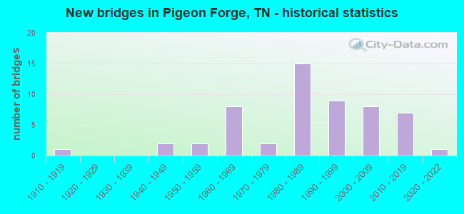
- New bridges - historical statistics
- 11910-1919
- 21940-1949
- 21950-1959
- 81960-1969
- 21970-1979
- 151980-1989
- 91990-1999
- 82000-2009
- 72010-2019
- 12020-2022
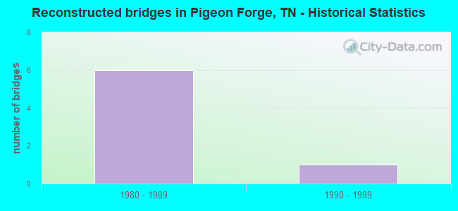
- Reconstructed bridges - Historical Statistics
- 61980-1989
- 11990-1999
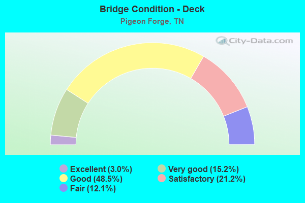
- Bridge Condition - Deck
- 3.0%Excellent
- 15.2%Very good
- 48.5%Good
- 21.2%Satisfactory
- 12.1%Fair
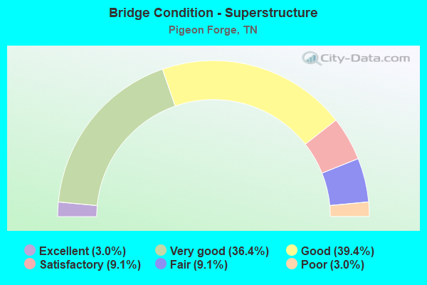
- Bridge Condition - Superstructure
- 3.0%Excellent
- 36.4%Very good
- 39.4%Good
- 9.1%Satisfactory
- 9.1%Fair
- 3.0%Poor
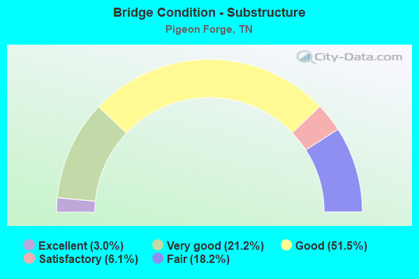
- Bridge Condition - Substructure
- 3.0%Excellent
- 21.2%Very good
- 51.5%Good
- 6.1%Satisfactory
- 18.2%Fair
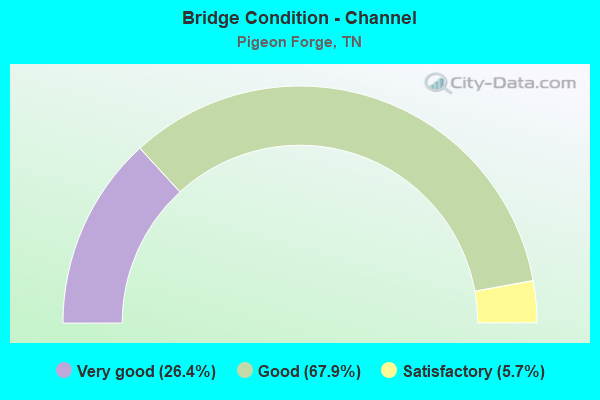
- Bridge Condition - Channel
- 26.4%Very good
- 67.9%Good
- 5.7%Satisfactory
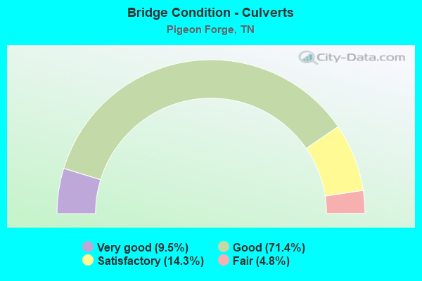
- Bridge Condition - Culverts
- 9.5%Very good
- 71.4%Good
- 14.3%Satisfactory
- 4.8%Fair
Find on map >> Show street view
Structure Number: 78S25330001, Location: NEAR WILLIAMSBURG (Lat: 35.782700, Lng: -83.548233), Route carried "on" structure: City street 449, Year Built: 1984, Year Reconstructed: 1995, Status: Open, Structure Length: 4.27m (14.01ft), Average Daily Traffic: 19,565 (year 2020), Truck Traffic: 9%, Average Future Daily Traffic: 31,304 (year 2041), Design Load: HS 20, Features Intersected: LITTLE PIGEON RIVER
Minimum Vertical Clearance: 4.55m (14.93ft), Kilometerpoint: 0.209, Lanes on structure: 2, Base Highway Network: Yes, Owner: State Highway Agency, Approaching Roadway Width: 9.1m (29.9ft), Material/Design: Prestressed concrete, Design/Construction: Box Beam or Girders - Single/Spread, Number Of Spans In Main Unit: 3, Length of Maximum Span: 14.3m (46.9ft), Curb-To-Curb Width: 9.1m (29.9ft), Out-to-Out Width: 9.8m (32.2ft)
Condition: Deck: Good, Superstructure: Good, Substructure: Good, Channel: Good, Operating Rating: 50.4 metric tons, Method Used To Determine Operating Rating: Load Factor (LF), Inventory Rating: 29.7 metric tons, Method Used To Determine Inventory Rating: Load Factor (LF), Structural Evaluation: Better than present minimum criteria, Deck Geometry: High priority of corrective action, Waterway Adequacy: Equal to present desirable criteria, Approach Roadway Alignment: Equal to present desirable criteria, Length Of Structure Improvement: 4.27m (14.01ft), Designated Inspection Frequency: Every 24 months, Inspection Date: August 2021, Bridge Improvement Cost: $430,000, Roadway Improvement Cost: $44,000, Total Project Cost: $646,000 ( Estimate for 2021), Deck Structure Type: Concrete Precast Panels, Wearing Surface/Protective System: Wearing Surface: Monolithic Concrete, Deck Protection: Epoxy Coated Reinforcing
Find on map >> Show street view
Structure Number: 78S25330003, Location: 1 M E OF PIGEON FORGE (Lat: 35.789167, Lng: -83.535767), Route carried "on" structure: County highway 1286, Year Built: 1960, Status: Open, Structure Length: 1.34m (4.40ft), Average Daily Traffic: 8,544 (year 2020), Truck Traffic: 4%, Average Future Daily Traffic: 13,670 (year 2041), Design Load: H 15, Features Intersected: MIDDLE CREEK
Minimum Vertical Clearance: 30+ m (98+ ft), Kilometerpoint: 1.239, Lanes on structure: 2, Owner: County Highway Agency, Approaching Roadway Width: 6.7m (22.0ft), Skew: 4 degrees, Material/Design: Concrete continuous, Design/Construction: Culvert, Number Of Spans In Main Unit: 3, Length of Maximum Span: 3.7m (12.1ft)
Condition: Channel: Good, Culverts: Satisfactory, Operating Rating: 45.0 metric tons, Method Used To Determine Operating Rating: Load Factor (LF), Inventory Rating: 26.1 metric tons, Method Used To Determine Inventory Rating: Load Factor (LF), Structural Evaluation: Equal to present minimum criteria, Waterway Adequacy: Better than present minimum criteria, Approach Roadway Alignment: Equal to present desirable criteria, Designated Inspection Frequency: Every 24 months, Inspection Date: May 2021
Find on map >> Show street view
Structure Number: 78S25330005, Location: 4.9 M NE OF GATLINBURG (Lat: 35.784417, Lng: -83.505900), Route carried "on" structure: County highway 1286, Year Built: 1960, Status: Open, Structure Length: 0.98m (3.22ft), Average Daily Traffic: 8,544 (year 2020), Truck Traffic: 4%, Average Future Daily Traffic: 14,144 (year 2041), Design Load: H 15, Features Intersected: MIDDLE CREEK
Minimum Vertical Clearance: 30+ m (98+ ft), Kilometerpoint: 4.297, Lanes on structure: 2, Owner: County Highway Agency, Approaching Roadway Width: 6.4m (21.0ft), Skew: 4 degrees, Material/Design: Concrete continuous, Design/Construction: Culvert, Number Of Spans In Main Unit: 2, Length of Maximum Span: 3.0m (9.8ft)
Condition: Channel: Good, Culverts: Good, Operating Rating: 89.1 metric tons, Method Used To Determine Operating Rating: Load Factor (LF), Inventory Rating: 32.4 metric tons, Method Used To Determine Inventory Rating: Load Factor (LF), Structural Evaluation: Better than present minimum criteria, Waterway Adequacy: Better than present minimum criteria, Approach Roadway Alignment: Equal to present desirable criteria, Designated Inspection Frequency: Every 24 months, Inspection Date: May 2021
Find on map >> Show street view
Structure Number: 78S25330007, Location: 6 M NE OF GATLINBURG (Lat: 35.784733, Lng: -83.499233), Route carried "on" structure: County highway 1286, Year Built: 1950, Status: Open, Structure Length: 0.76m (2.49ft), Average Daily Traffic: 8,544 (year 2020), Truck Traffic: 4%, Average Future Daily Traffic: 14,144 (year 2041), Design Load: HS 20, Features Intersected: MIDDLE CREEK
Minimum Vertical Clearance: 30+ m (98+ ft), Kilometerpoint: 4.925, Lanes on structure: 2, Owner: County Highway Agency, Approaching Roadway Width: 6.4m (21.0ft), Skew: 4 degrees, Material/Design: Concrete continuous, Design/Construction: Culvert, Number Of Spans In Main Unit: 2, Length of Maximum Span: 2.4m (7.9ft)
Condition: Channel: Good, Culverts: Good, Operating Rating: 26.1 metric tons, Method Used To Determine Operating Rating: Load Factor (LF), Inventory Rating: 24.3 metric tons, Method Used To Determine Inventory Rating: Load Factor (LF), Structural Evaluation: Equal to present minimum criteria, Waterway Adequacy: Better than present minimum criteria, Approach Roadway Alignment: Equal to present desirable criteria, Designated Inspection Frequency: Every 24 months, Inspection Date: May 2021
Find on map >> Show street view
Structure Number: 78S26050001, Location: 1.7 M NE OF PIGEON FORGE (Lat: 35.803967, Lng: -83.538500), Route carried "on" structure: City street 449, Year Built: 2005, Status: Open, Structure Length: 8.14m (26.71ft), Average Daily Traffic: 19,565 (year 2020), Truck Traffic: 9%, Average Future Daily Traffic: 31,304 (year 2041), Design Load: HS 20, Features Intersected: MIDDLE CREEK
Minimum Vertical Clearance: 30+ m (98+ ft), Kilometerpoint: 2.929, Lanes on structure: 5, Base Highway Network: Yes, Owner: State Highway Agency, Approaching Roadway Width: 14.6m (47.9ft), Skew: 4 degrees, Material/Design: Prestressed concrete continuous, Design/Construction: Stringer/Multi-beam, Number Of Spans In Main Unit: 4, Length of Maximum Span: 20.8m (68.2ft), Curb or Sidewalk Widths: Left: 2.1m (6.9ft), Right: 2.1m (6.9ft), Curb-To-Curb Width: 19.2m (63.0ft), Out-to-Out Width: 24.0m (78.7ft)
Condition: Deck: Good, Superstructure: Good, Substructure: Good, Channel: Good, Operating Rating: 41.4 metric tons, Method Used To Determine Operating Rating: Load Factor (LF), Inventory Rating: 32.4 metric tons, Method Used To Determine Inventory Rating: Load Factor (LF), Structural Evaluation: Better than present minimum criteria, Deck Geometry: Meets minimum limits, Waterway Adequacy: Equal to present desirable criteria, Approach Roadway Alignment: Equal to present desirable criteria, Designated Inspection Frequency: Every 24 months, Inspection Date: August 2021, Deck Structure Type: Concrete Cast-file-Place, Wearing Surface/Protective System: Wearing Surface: Monolithic Concrete, Deck Protection: Epoxy Coated Reinforcing
Find on map >> Show street view
Structure Number: 78SR0710039, Location: IN PIGEON FORGE (Lat: 35.773533, Lng: -83.537050), Route carried "on" structure: US 321, Year Built: 1958, Status: Open, Structure Length: 9.17m (30.09ft), Average Daily Traffic: 35,927 (year 2020), Truck Traffic: 9%, Average Future Daily Traffic: 57,483 (year 2041), Design Load: H 20, Features Intersected: W.FK.LITTLE PIGEON RIVER, Facility Carried by Structure: FAP 71
Minimum Vertical Clearance: 30+ m (98+ ft), Kilometerpoint: 33.861, Lanes on structure: 2, Base Highway Network: Yes, Owner: State Highway Agency, Approaching Roadway Width: 9.1m (29.9ft), Skew: 15 degrees, Material/Design: Concrete, Design/Construction: Tee Beam, Number Of Spans In Main Unit: 7, Length of Maximum Span: 13.1m (43.0ft), Curb-To-Curb Width: 8.5m (27.9ft), Out-to-Out Width: 10.5m (34.4ft)
Condition: Deck: Fair, Superstructure: Good, Substructure: Fair, Channel: Good, Operating Rating: 49.5 metric tons, Method Used To Determine Operating Rating: Load Factor (LF), Inventory Rating: 29.7 metric tons, Method Used To Determine Inventory Rating: Load Factor (LF), Structural Evaluation: Somewhat better than minimum adequacy, Deck Geometry: High priority of corrective action, Waterway Adequacy: Better than present minimum criteria, Approach Roadway Alignment: Equal to present desirable criteria, Length Of Structure Improvement: 10.13m (33.23ft), Designated Inspection Frequency: Every 24 months, Inspection Date: September 2021, Bridge Improvement Cost: $2,743,000, Roadway Improvement Cost: $275,000, Total Project Cost: $4,115,000 ( Estimate for 2021), Deck Structure Type: Concrete Cast-file-Place, Wearing Surface/Protective System: Wearing Surface: Bituminous
Find on map >> Show street view
Structure Number: 78SR0710041, Location: IN PIGEON FORGE (Lat: 35.807317, Lng: -83.577567), Route carried "on" structure: US 441, Year Built: 1967, Year Reconstructed: 1991, Status: Open, Structure Length: 5.67m (18.60ft), Average Daily Traffic: 44,483 (year 2020), Truck Traffic: 9%, Average Future Daily Traffic: 71,173 (year 2041), Design Load: HS 20, Features Intersected: LITTLE PIGEON RIVER RL, Facility Carried by Structure: FAP 71
Minimum Vertical Clearance: 30+ m (98+ ft), Kilometerpoint: 39.155, Lanes on structure: 3, Base Highway Network: Yes, Owner: State Highway Agency, Approaching Roadway Width: 11.0m (36.1ft), Skew: 13 degrees, Material/Design: Prestressed concrete continuous, Design/Construction: Stringer/Multi-beam, Number Of Spans In Main Unit: 5, Length of Maximum Span: 13.1m (43.0ft), Curb-To-Curb Width: 12.1m (39.7ft), Out-to-Out Width: 21.7m (71.2ft)
Condition: Deck: Satisfactory, Superstructure: Good, Substructure: Good, Channel: Good, Operating Rating: 56.7 metric tons, Method Used To Determine Operating Rating: Load Factor (LF), Inventory Rating: 32.4 metric tons, Method Used To Determine Inventory Rating: Load Factor (LF), Structural Evaluation: Better than present minimum criteria, Deck Geometry: Meets minimum limits, Waterway Adequacy: Better than present minimum criteria, Approach Roadway Alignment: Equal to present desirable criteria, Length Of Structure Improvement: 5.67m (18.60ft), Designated Inspection Frequency: Every 24 months, Inspection Date: September 2021, Bridge Improvement Cost: $1,000, Roadway Improvement Cost: $1,000, Total Project Cost: $2,000 ( Estimate for 2021), Deck Structure Type: Concrete Cast-file-Place, Wearing Surface/Protective System: Wearing Surface: Monolithic Concrete, Deck Protection: Epoxy Coated Reinforcing
Find on map >> Show street view
Structure Number: 78SR0710042, Location: IN PIGEON FORGE (Lat: 35.807483, Lng: -83.577633), Route carried "on" structure: US 441, Year Built: 1949, Year Reconstructed: 1991, Status: Open, Structure Length: 5.67m (18.60ft), Average Daily Traffic: 44,483 (year 2020), Truck Traffic: 9%, Average Future Daily Traffic: 71,173 (year 2041), Design Load: HS 20, Features Intersected: LITTLE PIGEON RIVER LL, Facility Carried by Structure: FAP 71
Minimum Vertical Clearance: 30+ m (98+ ft), Kilometerpoint: 39.155, Lanes on structure: 3, Base Highway Network: Yes, Owner: State Highway Agency, Approaching Roadway Width: 11.0m (36.1ft), Skew: 13 degrees, Material/Design: Concrete, Design/Construction: Tee Beam, Number Of Spans In Main Unit: 5, Length of Maximum Span: 13.1m (43.0ft), Curb-To-Curb Width: 12.1m (39.7ft), Out-to-Out Width: 15.1m (49.5ft)
Condition: Deck: Satisfactory, Superstructure: Fair, Substructure: Satisfactory, Channel: Good, Operating Rating: 79.2 metric tons, Method Used To Determine Operating Rating: Load Factor (LF), Inventory Rating: 32.4 metric tons, Method Used To Determine Inventory Rating: Load Factor (LF), Structural Evaluation: Somewhat better than minimum adequacy, Deck Geometry: Meets minimum limits, Waterway Adequacy: Better than present minimum criteria, Approach Roadway Alignment: Equal to present desirable criteria, Length Of Structure Improvement: 5.67m (18.60ft), Designated Inspection Frequency: Every 24 months, Inspection Date: September 2021, Bridge Improvement Cost: $473,000, Roadway Improvement Cost: $48,000, Total Project Cost: $710,000 ( Estimate for 2021), Deck Structure Type: Concrete Cast-file-Place, Wearing Surface/Protective System: Wearing Surface: Monolithic Concrete, Deck Protection: Epoxy Coated Reinforcing
Find on map >> Show street view
Structure Number: 78SR0710043, Location: 1.33 MI.N.OF PIGEON FORGE (Lat: 35.826150, Lng: -83.575383), Route carried "on" structure: US 441, Year Built: 1949, Year Reconstructed: 1989, Status: Open, Structure Length: 5.67m (18.60ft), Average Daily Traffic: 44,483 (year 2020), Truck Traffic: 9%, Average Future Daily Traffic: 71,173 (year 2041), Design Load: HS 20, Features Intersected: LITTLE PIGEON RIVER RL, Facility Carried by Structure: FAP 71
Minimum Vertical Clearance: 30+ m (98+ ft), Kilometerpoint: 41.328, Lanes on structure: 4, Base Highway Network: Yes, Owner: State Highway Agency, Approaching Roadway Width: 11.0m (36.1ft), Skew: 10 degrees, Material/Design: Concrete, Design/Construction: Tee Beam, Number Of Spans In Main Unit: 5, Length of Maximum Span: 13.1m (43.0ft), Curb-To-Curb Width: 14.6m (47.9ft), Out-to-Out Width: 18.1m (59.4ft)
Condition: Deck: Fair, Superstructure: Good, Substructure: Good, Channel: Good, Operating Rating: 67.5 metric tons, Method Used To Determine Operating Rating: Load Factor (LF), Inventory Rating: 32.4 metric tons, Method Used To Determine Inventory Rating: Load Factor (LF), Structural Evaluation: Better than present minimum criteria, Deck Geometry: High priority of replacement, Waterway Adequacy: Better than present minimum criteria, Approach Roadway Alignment: Equal to present desirable criteria, Length Of Structure Improvement: 5.67m (18.60ft), Designated Inspection Frequency: Every 24 months, Inspection Date: September 2021, Bridge Improvement Cost: $549,000, Roadway Improvement Cost: $55,000, Total Project Cost: $824,000 ( Estimate for 2021), Deck Structure Type: Concrete Cast-file-Place, Wearing Surface/Protective System: Wearing Surface: Monolithic Concrete, Deck Protection: Epoxy Coated Reinforcing
Find on map >> Show street view
Structure Number: 78SR0710044, Location: 1.33 MI.N.OF PIGEON FORGE (Lat: 35.826167, Lng: -83.575600), Route carried "on" structure: US 71, Year Built: 1967, Year Reconstructed: 1989, Status: Open, Structure Length: 6.74m (22.11ft), Average Daily Traffic: 44,483 (year 2020), Truck Traffic: 9%, Average Future Daily Traffic: 71,173 (year 2041), Design Load: HS 20+Mod, Features Intersected: LITTLE PIGEON RIVER LL
Minimum Vertical Clearance: 30+ m (98+ ft), Kilometerpoint: 41.328, Lanes on structure: 2, Base Highway Network: Yes, Owner: State Highway Agency, Approaching Roadway Width: 11.0m (36.1ft), Skew: 10 degrees, Material/Design: Prestressed concrete, Design/Construction: Stringer/Multi-beam, Number Of Spans In Main Unit: 5, Length of Maximum Span: 13.4m (44.0ft), Curb-To-Curb Width: 14.6m (47.9ft), Out-to-Out Width: 18.1m (59.4ft)
Condition: Deck: Fair, Superstructure: Good, Substructure: Good, Channel: Satisfactory, Operating Rating: 63.9 metric tons, Method Used To Determine Operating Rating: Load Factor (LF), Inventory Rating: 32.4 metric tons, Method Used To Determine Inventory Rating: Load Factor (LF), Structural Evaluation: Better than present minimum criteria, Deck Geometry: Superior to present desirable criteria, Waterway Adequacy: Better than present minimum criteria, Approach Roadway Alignment: Equal to present desirable criteria, Designated Inspection Frequency: Every 24 months, Inspection Date: September 2021, Deck Structure Type: Concrete Cast-file-Place, Wearing Surface/Protective System: Wearing Surface: Monolithic Concrete, Deck Protection: Epoxy Coated Reinforcing
Find on map >> Show street view
Structure Number: 78SR0730037, Location: 2 MI SW OF PIGEON FORGE (Lat: 35.781500, Lng: -83.618650), Route carried "on" structure: US 321, Year Built: 1982, Status: Open, Structure Length: 0.64m (2.10ft), Average Daily Traffic: 11,589 (year 2020), Truck Traffic: 11%, Average Future Daily Traffic: 18,542 (year 2041), Design Load: HS 20, Features Intersected: LOST BRANCH, Facility Carried by Structure: FAP 73
Minimum Vertical Clearance: 30+ m (98+ ft), Kilometerpoint: 12.875, Lanes on structure: 2, Base Highway Network: Yes, Owner: State Highway Agency, Approaching Roadway Width: 10.4m (34.1ft), Skew: 4 degrees, Material/Design: Concrete continuous, Design/Construction: Culvert, Number Of Spans In Main Unit: 2, Length of Maximum Span: 2.4m (7.9ft)
Condition: Channel: Good, Culverts: Good, Operating Rating: 54.0 metric tons, Method Used To Determine Operating Rating: Field evaluation and documented engineering judgment, Inventory Rating: 32.4 metric tons, Method Used To Determine Inventory Rating: Field evaluation and documented engineering judgment, Structural Evaluation: Better than present minimum criteria, Waterway Adequacy: Better than present minimum criteria, Approach Roadway Alignment: Equal to present desirable criteria, Designated Inspection Frequency: Every 24 months, Inspection Date: September 2021
Find on map >> Show street view
Structure Number: 78SR4490003, Location: 7 M SE OF JCT SR35 & SR71 (Lat: 35.817933, Lng: -83.540000), Route carried "on" structure: County highway 449, Year Built: 2001, Status: Open, Structure Length: 15.18m (49.80ft), Average Daily Traffic: 20,626 (year 2020), Truck Traffic: 5%, Average Future Daily Traffic: 33,002 (year 2041), Design Load: HS 20, Features Intersected: MIDDLE CREEK
Minimum Vertical Clearance: 30+ m (98+ ft), Kilometerpoint: 4.442, Lanes on structure: 4, Base Highway Network: Yes, Owner: State Highway Agency, Approaching Roadway Width: 38.1m (125.0ft), Skew: 4 degrees, Material/Design: Prestressed concrete continuous, Design/Construction: Stringer/Multi-beam, Number Of Spans In Main Unit: 5, Length of Maximum Span: 31.0m (101.7ft), Curb or Sidewalk Widths: Left: 2.1m (6.9ft), Right: 3.0m (9.8ft), Curb-To-Curb Width: 32.0m (105.0ft), Out-to-Out Width: 37.7m (123.7ft)
Condition: Deck: Very good, Superstructure: Good, Substructure: Good, Channel: Very good, Operating Rating: 65.7 metric tons, Method Used To Determine Operating Rating: Load Factor (LF), Inventory Rating: 32.4 metric tons, Method Used To Determine Inventory Rating: Load Factor (LF), Structural Evaluation: Better than present minimum criteria, Deck Geometry: Superior to present desirable criteria, Waterway Adequacy: Equal to present desirable criteria, Approach Roadway Alignment: Equal to present desirable criteria, Designated Inspection Frequency: Every 24 months, Inspection Date: August 2021, Deck Structure Type: Concrete Precast Panels, Wearing Surface/Protective System: Wearing Surface: Monolithic Concrete, Deck Protection: Epoxy Coated Reinforcing
Find on map >> Show street view
Structure Number: 5460084P, Location: 3.3 MILES NORTH FROM NPS (Lat: 35.762444, Lng: -83.523444), Route carried "on" structure: Federal lands road 11, Year Built: 1960, Status: Open, Structure Length: 5.72m (18.77ft), Average Daily Traffic: 4,332 (year 2010), Truck Traffic: 1%, Average Future Daily Traffic: 4,777 (year 2030), Design Load: H 20, Features Intersected: WEST PRONG LPR, Facility Carried by Structure: SPUR CROSSOVER ROA
Minimum Vertical Clearance: 30+ m (98+ ft), Kilometerpoint: 1.950, Lanes on structure: 2, Owner: National Park Service, Approaching Roadway Width: 11.0m (36.1ft), Material/Design: Prestressed concrete, Design/Construction: Stringer/Multi-beam, Number Of Spans In Main Unit: 3, Length of Maximum Span: 19.2m (63.0ft), Curb or Sidewalk Widths: Left: 0.8m (2.6ft), Right: 0.8m (2.6ft), Curb-To-Curb Width: 7.9m (25.9ft), Out-to-Out Width: 10.1m (33.1ft)
Condition: Deck: Good, Superstructure: Satisfactory, Substructure: Satisfactory, Channel: Satisfactory, Operating Rating: 38.1 metric tons, Method Used To Determine Operating Rating: Field evaluation and documented engineering judgment, Inventory Rating: 23.0 metric tons, Method Used To Determine Inventory Rating: Field evaluation and documented engineering judgment, Structural Evaluation: Equal to present minimum criteria, Deck Geometry: High priority of corrective action, Waterway Adequacy: Equal to present desirable criteria, Approach Roadway Alignment: Equal to present desirable criteria, Designated Inspection Frequency: Every 24 months, Inspection Date: May 2020, Bridge Improvement Cost: $110,000, Roadway Improvement Cost: $11,000, Total Project Cost: $165,000 ( Estimate for 2016), Deck Structure Type: Concrete Cast-file-Place, Wearing Surface/Protective System: Wearing Surface: Bituminous
Find on map >> Show street view
Structure Number: 78054110001, Location: CITY OF PIGEON FORGE (Lat: 35.798700, Lng: -83.560683), Route carried "under" structure: City street 5411, Year Built: 2020, Structure Length: 0. m, Average Daily Traffic: 20,732 (year 2020), Truck Traffic: 4%, Features Intersected: PED WALK / TEASTER LANE
Minimum Vertical Clearance: 5.49m (18.01ft), Kilometerpoint: 1.448, Lanes under structure: 5, Material/Design: Steel, Design/Construction: Truss - Thru, Length of Maximum Span: 28.0m (91.9ft)