Bridge Statistics for Pike Road, Alabama (AL)
Condition, Traffic, Stress, Structural Evaluation, Project Costs
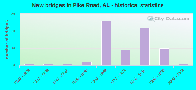
- New bridges - historical statistics
- 11920-1929
- 11930-1939
- 11940-1949
- 21950-1959
- 261960-1969
- 91970-1979
- 221980-1989
- 101990-1999
- 12000-2009
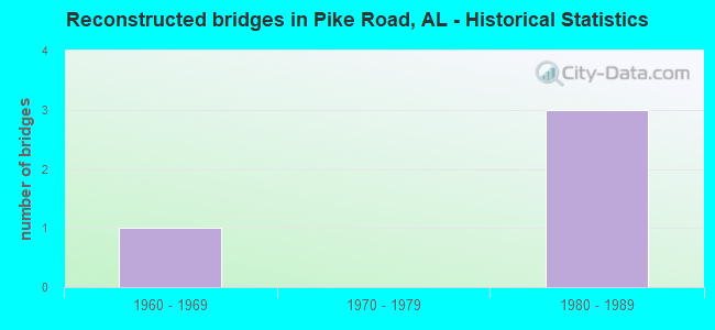
- Reconstructed bridges - Historical Statistics
- 11960-1969
- 01970-1979
- 31980-1989
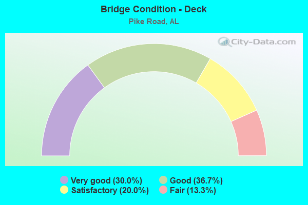
- Bridge Condition - Deck
- 30.0%Very good
- 36.7%Good
- 20.0%Satisfactory
- 13.3%Fair
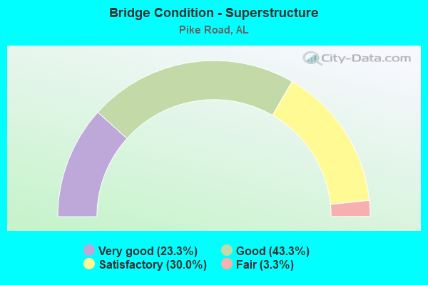
- Bridge Condition - Superstructure
- 23.3%Very good
- 43.3%Good
- 30.0%Satisfactory
- 3.3%Fair
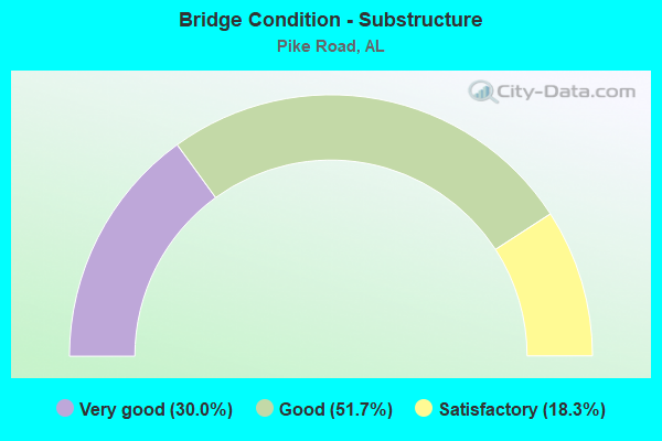
- Bridge Condition - Substructure
- 30.0%Very good
- 51.7%Good
- 18.3%Satisfactory
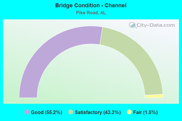
- Bridge Condition - Channel
- 55.2%Good
- 43.3%Satisfactory
- 1.5%Fair
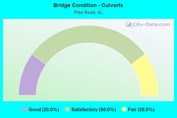
- Bridge Condition - Culverts
- 20.0%Good
- 60.0%Satisfactory
- 20.0%Fair
Find on map >> Show street view
Structure Number: 13317, Location: 3 MI NORTH OF BULLOCK CO (Lat: 32.279789, Lng: -86.007344), Route carried "on" structure: County highway 101, Year Built: 1984, Status: Open, Structure Length: 3.11m (10.20ft), Average Daily Traffic: 195 (year 1988), Truck Traffic: 1%, Average Future Daily Traffic: 250 (year 2041), Design Load: H 15, Features Intersected: CREEK, Facility Carried by Structure: FLOWERS ROAD
Minimum Vertical Clearance: 30+ m (98+ ft), Kilometerpoint: 0.010, Lanes on structure: 2, Owner: County Highway Agency, Approaching Roadway Width: 11.0m (36.1ft), Material/Design: Concrete, Design/Construction: Channel Beam, Number Of Spans In Main Unit: 3, Length of Maximum Span: 10.4m (34.1ft), Curb-To-Curb Width: 8.7m (28.5ft), Out-to-Out Width: 9.4m (30.8ft)
Condition: Deck: Good, Superstructure: Good, Substructure: Good, Channel: Good, Operating Rating: 74.1 metric tons, Method Used To Determine Operating Rating: Load Factor (LF), Inventory Rating: 44.5 metric tons, Method Used To Determine Inventory Rating: Load Factor (LF), Structural Evaluation: Better than present minimum criteria, Deck Geometry: Equal to present minimum criteria, Waterway Adequacy: Better than present minimum criteria, Approach Roadway Alignment: Equal to present minimum criteria, Length Of Structure Improvement: 3.96m (12.99ft), Designated Inspection Frequency: Every 24 months, Inspection Date: July 2021, Bridge Improvement Cost: $815,000, Roadway Improvement Cost: $82,000, Total Project Cost: $897,000 ( Estimate for 2022), Deck Structure Type: Concrete Precast Panels, Wearing Surface/Protective System: Membrane: Other, Deck Protection: Other
Find on map >> Show street view
Structure Number: 13349, Location: 3.2 MI EAST OF MT ZION RD (Lat: 32.154522, Lng: -86.130539), Route carried "on" structure: County highway 24, Year Built: 1984, Status: Open, Structure Length: 2.93m (9.61ft), Average Daily Traffic: 85 (year 1988), Average Future Daily Traffic: 170 (year 2040), Design Load: H 15, Features Intersected: DRAINAGE RELIEF, Facility Carried by Structure: GOODWYN ROAD
Minimum Vertical Clearance: 30+ m (98+ ft), Kilometerpoint: 0.010, Lanes on structure: 2, Owner: County Highway Agency, Approaching Roadway Width: 11.0m (36.1ft), Material/Design: Concrete, Design/Construction: Channel Beam, Number Of Spans In Main Unit: 4, Length of Maximum Span: 7.3m (24.0ft), Curb-To-Curb Width: 7.3m (24.0ft), Out-to-Out Width: 8.2m (26.9ft)
Condition: Deck: Very good, Superstructure: Good, Substructure: Good, Channel: Satisfactory, Operating Rating: 71.9 metric tons, Method Used To Determine Operating Rating: Allowable Stress (AS), Inventory Rating: 47.1 metric tons, Method Used To Determine Inventory Rating: Allowable Stress (AS), Structural Evaluation: Better than present minimum criteria, Deck Geometry: Equal to present minimum criteria, Waterway Adequacy: Better than present minimum criteria, Approach Roadway Alignment: Better than present minimum criteria, Length Of Structure Improvement: 3.84m (12.60ft), Designated Inspection Frequency: Every 24 months, Inspection Date: April 2020, Bridge Improvement Cost: $684,000, Roadway Improvement Cost: $68,000, Total Project Cost: $752,000 ( Estimate for 2022), Deck Structure Type: Concrete Precast Panels, Wearing Surface/Protective System: Wearing Surface: Bituminous, Membrane: Other, Deck Protection: Other
Find on map >> Show street view
Structure Number: 13583, Location: 0.4 MI.E.OF MERIWETHER RD (Lat: 32.268519, Lng: -86.167197), Route carried "on" structure: US 82, Year Built: 1985, Status: Open, Structure Length: 10.00m (32.81ft), Average Daily Traffic: 7,825 (year 2013), Truck Traffic: 20%, Average Future Daily Traffic: 10,131 (year 2033), Design Load: HS 20, Features Intersected: LITTLE CATOMA CREEK
Minimum Vertical Clearance: 30+ m (98+ ft), Kilometerpoint: 265.051, Lanes on structure: 2, Owner: State Highway Agency, Approaching Roadway Width: 12.2m (40.0ft), Skew: 10 degrees, Material/Design: Prestressed concrete continuous, Design/Construction: Stringer/Multi-beam, Number Of Spans In Main Unit: 8, Length of Maximum Span: 12.5m (41.0ft), Curb-To-Curb Width: 12.2m (40.0ft), Out-to-Out Width: 13.0m (42.7ft)
Condition: Deck: Satisfactory, Superstructure: Good, Substructure: Satisfactory, Channel: Satisfactory, Operating Rating: 49.0 metric tons, Method Used To Determine Operating Rating: Load Factor (LF), Inventory Rating: 29.3 metric tons, Method Used To Determine Inventory Rating: Load Factor (LF), Structural Evaluation: Equal to present minimum criteria, Deck Geometry: Better than present minimum criteria, Waterway Adequacy: Superior to present desirable criteria, Approach Roadway Alignment: Better than present minimum criteria, Length Of Structure Improvement: 10.93m (35.86ft), Designated Inspection Frequency: Every 24 months, Inspection Date: October 2021, Bridge Improvement Cost: $3,148,000, Roadway Improvement Cost: $315,000, Total Project Cost: $3,463,000 ( Estimate for 2022), Deck Structure Type: Concrete Cast-file-Place
Find on map >> Show street view
Structure Number: 13584, Location: 0.6 MI.E.OF MERIWETHER RD (Lat: 32.266519, Lng: -86.165042), Route carried "on" structure: US 82, Year Built: 1985, Status: Open, Structure Length: 5.00m (16.40ft), Average Daily Traffic: 7,825 (year 2013), Truck Traffic: 20%, Average Future Daily Traffic: 10,131 (year 2033), Design Load: HS 20, Features Intersected: LITTLE CATOMA CRK RELIEF
Minimum Vertical Clearance: 30+ m (98+ ft), Kilometerpoint: 265.352, Lanes on structure: 2, Owner: State Highway Agency, Approaching Roadway Width: 12.2m (40.0ft), Skew: 10 degrees, Material/Design: Prestressed concrete continuous, Design/Construction: Stringer/Multi-beam, Number Of Spans In Main Unit: 4, Length of Maximum Span: 12.5m (41.0ft), Curb-To-Curb Width: 12.2m (40.0ft), Out-to-Out Width: 13.0m (42.7ft)
Condition: Deck: Satisfactory, Superstructure: Good, Substructure: Good, Channel: Good, Operating Rating: 49.0 metric tons, Method Used To Determine Operating Rating: Load Factor (LF), Inventory Rating: 29.3 metric tons, Method Used To Determine Inventory Rating: Load Factor (LF), Structural Evaluation: Better than present minimum criteria, Deck Geometry: Better than present minimum criteria, Waterway Adequacy: Superior to present desirable criteria, Approach Roadway Alignment: Better than present minimum criteria, Length Of Structure Improvement: 6.02m (19.75ft), Designated Inspection Frequency: Every 24 months, Inspection Date: September 2021, Bridge Improvement Cost: $1,732,000, Roadway Improvement Cost: $173,000, Total Project Cost: $1,905,000 ( Estimate for 2022), Deck Structure Type: Concrete Cast-file-Place
Find on map >> Show street view
Structure Number: 13585, Location: 0.8 MI.E.OF MERIWETHER RD (Lat: 32.264972, Lng: -86.163128), Route carried "on" structure: US 82, Year Built: 1985, Status: Open, Structure Length: 7.50m (24.61ft), Average Daily Traffic: 7,825 (year 2013), Truck Traffic: 20%, Average Future Daily Traffic: 10,131 (year 2033), Design Load: HS 20, Features Intersected: LITTLE CATOMA CRK RELIEF
Minimum Vertical Clearance: 30+ m (98+ ft), Kilometerpoint: 265.593, Lanes on structure: 2, Owner: State Highway Agency, Approaching Roadway Width: 12.2m (40.0ft), Skew: 13 degrees, Material/Design: Prestressed concrete continuous, Design/Construction: Stringer/Multi-beam, Number Of Spans In Main Unit: 6, Length of Maximum Span: 12.5m (41.0ft), Curb-To-Curb Width: 12.2m (40.0ft), Out-to-Out Width: 13.0m (42.7ft)
Condition: Deck: Good, Superstructure: Good, Substructure: Good, Channel: Good, Operating Rating: 49.0 metric tons, Method Used To Determine Operating Rating: Load Factor (LF), Inventory Rating: 29.3 metric tons, Method Used To Determine Inventory Rating: Load Factor (LF), Structural Evaluation: Better than present minimum criteria, Deck Geometry: Better than present minimum criteria, Waterway Adequacy: Superior to present desirable criteria, Approach Roadway Alignment: Better than present minimum criteria, Length Of Structure Improvement: 8.52m (27.95ft), Designated Inspection Frequency: Every 24 months, Inspection Date: November 2021, Bridge Improvement Cost: $2,455,000, Roadway Improvement Cost: $246,000, Total Project Cost: $2,701,000 ( Estimate for 2022), Deck Structure Type: Concrete Cast-file-Place
Find on map >> Show street view
Structure Number: 14231, Location: 2.9 MI N OF BULLOCKCOLINE (Lat: 32.277558, Lng: -86.008167), Route carried "on" structure: County highway 37, Year Built: 1987, Status: Open, Structure Length: 1.46m (4.79ft), Average Daily Traffic: 195 (year 1988), Truck Traffic: 1%, Average Future Daily Traffic: 250 (year 2041), Design Load: HS 20, Features Intersected: MATHEWS SLOUGH, Facility Carried by Structure: FLOWERS ROAD
Minimum Vertical Clearance: 30+ m (98+ ft), Kilometerpoint: 0.010, Lanes on structure: 2, Owner: County Highway Agency, Approaching Roadway Width: 10.4m (34.1ft), Material/Design: Concrete, Design/Construction: Channel Beam, Number Of Spans In Main Unit: 2, Length of Maximum Span: 7.3m (24.0ft), Curb-To-Curb Width: 8.7m (28.5ft), Out-to-Out Width: 9.5m (31.2ft)
Condition: Deck: Good, Superstructure: Very good, Substructure: Very good, Channel: Satisfactory, Operating Rating: 78.1 metric tons, Method Used To Determine Operating Rating: Load Factor (LF), Inventory Rating: 46.8 metric tons, Method Used To Determine Inventory Rating: Load Factor (LF), Structural Evaluation: Equal to present desirable criteria, Deck Geometry: Equal to present minimum criteria, Waterway Adequacy: Better than present minimum criteria, Approach Roadway Alignment: Better than present minimum criteria, Length Of Structure Improvement: 2.14m (7.02ft), Designated Inspection Frequency: Every 24 months, Inspection Date: July 2021, Bridge Improvement Cost: $454,000, Roadway Improvement Cost: $45,000, Total Project Cost: $499,000 ( Estimate for 2022), Deck Structure Type: Concrete Precast Panels, Wearing Surface/Protective System: Membrane: Other, Deck Protection: Other
Find on map >> Show street view
Structure Number: 14243, Location: 0.7 MI.S. US 82 (Lat: 32.185000, Lng: -86.118333), Route carried "on" structure: US 231, Year Built: 1987, Status: Open, Structure Length: 3.11m (10.20ft), Average Daily Traffic: 9,255 (year 2013), Truck Traffic: 21%, Average Future Daily Traffic: 12,030 (year 2033), Design Load: HS 20, Features Intersected: DRY CREEK RELIEF
Minimum Vertical Clearance: 30+ m (98+ ft), Kilometerpoint: 169.316, Lanes on structure: 2, Base Highway Network: Yes, Owner: State Highway Agency, Approaching Roadway Width: 13.4m (44.0ft), Skew: 10 degrees, Material/Design: Prestressed concrete continuous, Design/Construction: Stringer/Multi-beam, Number Of Spans In Main Unit: 3, Length of Maximum Span: 10.4m (34.1ft), Curb-To-Curb Width: 12.2m (40.0ft), Out-to-Out Width: 13.0m (42.7ft)
Condition: Deck: Satisfactory, Superstructure: Good, Substructure: Good, Channel: Good, Operating Rating: 55.6 metric tons, Method Used To Determine Operating Rating: Load Factor (LF), Inventory Rating: 33.3 metric tons, Method Used To Determine Inventory Rating: Load Factor (LF), Structural Evaluation: Better than present minimum criteria, Deck Geometry: Better than present minimum criteria, Waterway Adequacy: Better than present minimum criteria, Approach Roadway Alignment: Better than present minimum criteria, Length Of Structure Improvement: 3.96m (12.99ft), Designated Inspection Frequency: Every 24 months, Inspection Date: July 2020, Bridge Improvement Cost: $1,141,000, Roadway Improvement Cost: $114,000, Total Project Cost: $1,255,000 ( Estimate for 2022), Deck Structure Type: Concrete Cast-file-Place
Find on map >> Show street view
Structure Number: 14244, Location: 0.6 MI. S. US 82 (Lat: 32.185000, Lng: -86.118333), Route carried "on" structure: US 231, Year Built: 1987, Status: Open, Structure Length: 3.11m (10.20ft), Average Daily Traffic: 9,255 (year 2013), Truck Traffic: 21%, Average Future Daily Traffic: 12,030 (year 2033), Design Load: HS 20, Features Intersected: DRY CREEK RELIEF
Minimum Vertical Clearance: 30+ m (98+ ft), Kilometerpoint: 169.482, Lanes on structure: 2, Base Highway Network: Yes, Owner: State Highway Agency, Approaching Roadway Width: 13.4m (44.0ft), Skew: 10 degrees, Material/Design: Prestressed concrete continuous, Design/Construction: Stringer/Multi-beam, Number Of Spans In Main Unit: 3, Length of Maximum Span: 10.4m (34.1ft), Curb-To-Curb Width: 12.2m (40.0ft), Out-to-Out Width: 13.0m (42.7ft)
Condition: Deck: Satisfactory, Superstructure: Good, Substructure: Good, Channel: Good, Operating Rating: 55.6 metric tons, Method Used To Determine Operating Rating: Load Factor (LF), Inventory Rating: 33.3 metric tons, Method Used To Determine Inventory Rating: Load Factor (LF), Structural Evaluation: Better than present minimum criteria, Deck Geometry: Better than present minimum criteria, Waterway Adequacy: Equal to present desirable criteria, Approach Roadway Alignment: Better than present minimum criteria, Length Of Structure Improvement: 3.96m (12.99ft), Designated Inspection Frequency: Every 24 months, Inspection Date: July 2020, Bridge Improvement Cost: $1,141,000, Roadway Improvement Cost: $114,000, Total Project Cost: $1,255,000 ( Estimate for 2022), Deck Structure Type: Concrete Cast-file-Place
Find on map >> Show street view
Structure Number: 14245, Location: 0.5 MI.S.US 82 (Lat: 32.186667, Lng: -86.118333), Route carried "on" structure: US 231, Year Built: 1987, Status: Open, Structure Length: 3.11m (10.20ft), Average Daily Traffic: 9,255 (year 2013), Truck Traffic: 21%, Average Future Daily Traffic: 12,030 (year 2033), Design Load: HS 20, Features Intersected: DRY CREEK
Minimum Vertical Clearance: 30+ m (98+ ft), Kilometerpoint: 169.683, Lanes on structure: 2, Base Highway Network: Yes, Owner: State Highway Agency, Approaching Roadway Width: 13.4m (44.0ft), Skew: 10 degrees, Material/Design: Prestressed concrete continuous, Design/Construction: Stringer/Multi-beam, Number Of Spans In Main Unit: 3, Length of Maximum Span: 10.4m (34.1ft), Curb-To-Curb Width: 12.2m (40.0ft), Out-to-Out Width: 13.0m (42.7ft)
Condition: Deck: Satisfactory, Superstructure: Good, Substructure: Good, Channel: Satisfactory, Operating Rating: 55.6 metric tons, Method Used To Determine Operating Rating: Load Factor (LF), Inventory Rating: 33.3 metric tons, Method Used To Determine Inventory Rating: Load Factor (LF), Structural Evaluation: Better than present minimum criteria, Deck Geometry: Better than present minimum criteria, Waterway Adequacy: Superior to present desirable criteria, Approach Roadway Alignment: Better than present minimum criteria, Length Of Structure Improvement: 3.96m (12.99ft), Designated Inspection Frequency: Every 24 months, Inspection Date: August 2020, Bridge Improvement Cost: $1,141,000, Roadway Improvement Cost: $114,000, Total Project Cost: $1,255,000 ( Estimate for 2022), Deck Structure Type: Concrete Cast-file-Place
Find on map >> Show street view
Structure Number: 14489, Location: .1 MI N OF AL 110 (Lat: 32.309389, Lng: -86.021411), Route carried "on" structure: County highway , Year Built: 1988, Status: Open, Structure Length: 1.04m (3.41ft), Average Daily Traffic: 300 (year 1988), Truck Traffic: 1%, Average Future Daily Traffic: 600 (year 2041), Design Load: HS 20, Features Intersected: CREEK, Facility Carried by Structure: MARLER ROAD
Minimum Vertical Clearance: 30+ m (98+ ft), Kilometerpoint: 0.010, Lanes on structure: 2, Owner: City or Municipal Highway Agency, Approaching Roadway Width: 10.4m (34.1ft), Material/Design: Concrete, Design/Construction: Channel Beam, Number Of Spans In Main Unit: 1, Length of Maximum Span: 10.4m (34.1ft), Curb-To-Curb Width: 8.6m (28.2ft), Out-to-Out Width: 9.4m (30.8ft)
Condition: Deck: Very good, Superstructure: Very good, Substructure: Very good, Channel: Satisfactory, Operating Rating: 74.1 metric tons, Method Used To Determine Operating Rating: Load Factor (LF), Inventory Rating: 44.5 metric tons, Method Used To Determine Inventory Rating: Load Factor (LF), Structural Evaluation: Equal to present desirable criteria, Deck Geometry: Equal to present minimum criteria, Waterway Adequacy: Better than present minimum criteria, Approach Roadway Alignment: Better than present minimum criteria, Length Of Structure Improvement: 1.71m (5.61ft), Designated Inspection Frequency: Every 24 months, Inspection Date: June 2021, Bridge Improvement Cost: $352,000, Roadway Improvement Cost: $35,000, Total Project Cost: $387,000 ( Estimate for 2022), Deck Structure Type: Concrete Precast Panels
Find on map >> Show street view
Structure Number: 14548, Location: 10.6 MI N US 82 (Lat: 32.265581, Lng: -86.084292), Route carried "on" structure: County highway 22, Year Built: 1988, Status: Open, Structure Length: 2.07m (6.79ft), Average Daily Traffic: 320 (year 1988), Truck Traffic: 1%, Average Future Daily Traffic: 400 (year 2041), Design Load: HS 20, Features Intersected: MARKS SLOUGH, Facility Carried by Structure: OLD PIKE ROAD
Minimum Vertical Clearance: 30+ m (98+ ft), Kilometerpoint: 0.010, Lanes on structure: 2, Owner: County Highway Agency, Approaching Roadway Width: 10.4m (34.1ft), Material/Design: Concrete, Design/Construction: Channel Beam, Number Of Spans In Main Unit: 2, Length of Maximum Span: 10.4m (34.1ft), Curb-To-Curb Width: 7.4m (24.3ft), Out-to-Out Width: 8.2m (26.9ft)
Condition: Deck: Very good, Superstructure: Very good, Substructure: Very good, Channel: Good, Operating Rating: 75.2 metric tons, Method Used To Determine Operating Rating: Load Factor (LF), Inventory Rating: 45.2 metric tons, Method Used To Determine Inventory Rating: Load Factor (LF), Structural Evaluation: Equal to present desirable criteria, Deck Geometry: Somewhat better than minimum adequacy, Waterway Adequacy: Better than present minimum criteria, Approach Roadway Alignment: Equal to present minimum criteria, Length Of Structure Improvement: 2.84m (9.32ft), Designated Inspection Frequency: Every 24 months, Inspection Date: July 2021, Bridge Improvement Cost: $506,000, Roadway Improvement Cost: $51,000, Total Project Cost: $557,000 ( Estimate for 2022), Deck Structure Type: Concrete Precast Panels, Wearing Surface/Protective System: Wearing Surface: Bituminous
Find on map >> Show street view
Structure Number: 1455, Location: 3.6 MI N OF US 82 (Lat: 32.184056, Lng: -86.038106), Route carried "on" structure: County highway 22, Year Built: 1988, Status: Open, Structure Length: 1.04m (3.41ft), Average Daily Traffic: 350 (year 1988), Truck Traffic: 1%, Average Future Daily Traffic: 400 (year 2041), Design Load: HS 20, Features Intersected: DRAINAGE RELIEF, Facility Carried by Structure: OLD PIKE ROAD
Minimum Vertical Clearance: 30+ m (98+ ft), Kilometerpoint: 0.010, Lanes on structure: 2, Owner: County Highway Agency, Approaching Roadway Width: 10.4m (34.1ft), Material/Design: Concrete, Design/Construction: Channel Beam, Number Of Spans In Main Unit: 1, Length of Maximum Span: 10.4m (34.1ft), Curb-To-Curb Width: 7.4m (24.3ft), Out-to-Out Width: 8.2m (26.9ft)
Condition: Deck: Very good, Superstructure: Very good, Substructure: Very good, Channel: Good, Operating Rating: 75.2 metric tons, Method Used To Determine Operating Rating: Load Factor (LF), Inventory Rating: 45.2 metric tons, Method Used To Determine Inventory Rating: Load Factor (LF), Structural Evaluation: Equal to present desirable criteria, Deck Geometry: Somewhat better than minimum adequacy, Waterway Adequacy: Better than present minimum criteria, Approach Roadway Alignment: Better than present minimum criteria, Length Of Structure Improvement: 1.71m (5.61ft), Designated Inspection Frequency: Every 24 months, Inspection Date: July 2021, Bridge Improvement Cost: $305,000, Roadway Improvement Cost: $31,000, Total Project Cost: $336,000 ( Estimate for 2022), Deck Structure Type: Concrete Precast Panels, Wearing Surface/Protective System: Wearing Surface: Bituminous
Find on map >> Show street view
Structure Number: 14577, Location: 2.3 MI E US 82 (Lat: 32.186119, Lng: -86.055217), Route carried "on" structure: County highway 36, Year Built: 1988, Status: Open, Structure Length: 2.19m (7.19ft), Average Daily Traffic: 255 (year 1988), Truck Traffic: 1%, Average Future Daily Traffic: 325 (year 2040), Design Load: HS 20, Features Intersected: DRAINAGE RELIEF, Facility Carried by Structure: HAYNEVILLERIDGE RD
Minimum Vertical Clearance: 30+ m (98+ ft), Kilometerpoint: 0.010, Lanes on structure: 2, Owner: County Highway Agency, Approaching Roadway Width: 8.5m (27.9ft), Material/Design: Concrete, Design/Construction: Channel Beam, Number Of Spans In Main Unit: 3, Length of Maximum Span: 7.3m (24.0ft), Curb-To-Curb Width: 7.4m (24.3ft), Out-to-Out Width: 8.2m (26.9ft)
Condition: Deck: Very good, Superstructure: Good, Substructure: Very good, Channel: Good, Operating Rating: 55.8 metric tons, Method Used To Determine Operating Rating: Load Factor (LF), Inventory Rating: 33.5 metric tons, Method Used To Determine Inventory Rating: Load Factor (LF), Structural Evaluation: Better than present minimum criteria, Deck Geometry: Somewhat better than minimum adequacy, Waterway Adequacy: Better than present minimum criteria, Approach Roadway Alignment: Better than present minimum criteria, Length Of Structure Improvement: 3.00m (9.84ft), Designated Inspection Frequency: Every 24 months, Inspection Date: July 2020, Bridge Improvement Cost: $534,000, Roadway Improvement Cost: $53,000, Total Project Cost: $587,000 ( Estimate for 2022), Deck Structure Type: Concrete Precast Panels, Wearing Surface/Protective System: Wearing Surface: Bituminous
Find on map >> Show street view
Structure Number: 1458, Location: 2.1 MI E OF OLD PIKE RD (Lat: 32.237781, Lng: -86.019725), Route carried "on" structure: County highway 40, Year Built: 1988, Status: Open, Structure Length: 2.19m (7.19ft), Average Daily Traffic: 180 (year 1988), Truck Traffic: 1%, Average Future Daily Traffic: 190 (year 2041), Design Load: HS 20, Features Intersected: FIELDS SLOUGH, Facility Carried by Structure: LAWSON ROAD
Minimum Vertical Clearance: 30+ m (98+ ft), Kilometerpoint: 0.010, Lanes on structure: 2, Owner: County Highway Agency, Approaching Roadway Width: 8.5m (27.9ft), Skew: 9 degrees, Material/Design: Concrete, Design/Construction: Channel Beam, Number Of Spans In Main Unit: 3, Length of Maximum Span: 7.3m (24.0ft), Curb-To-Curb Width: 7.4m (24.3ft), Out-to-Out Width: 8.2m (26.9ft)
Condition: Deck: Very good, Superstructure: Very good, Substructure: Very good, Channel: Good, Operating Rating: 55.8 metric tons, Method Used To Determine Operating Rating: Load Factor (LF), Inventory Rating: 33.5 metric tons, Method Used To Determine Inventory Rating: Load Factor (LF), Structural Evaluation: Equal to present desirable criteria, Deck Geometry: Somewhat better than minimum adequacy, Waterway Adequacy: Better than present minimum criteria, Approach Roadway Alignment: Equal to present desirable criteria, Length Of Structure Improvement: 2.99m (9.81ft), Designated Inspection Frequency: Every 24 months, Inspection Date: June 2021, Bridge Improvement Cost: $533,000, Roadway Improvement Cost: $53,000, Total Project Cost: $586,000 ( Estimate for 2022), Deck Structure Type: Concrete Precast Panels, Wearing Surface/Protective System: Wearing Surface: Bituminous
Find on map >> Show street view
Structure Number: 14581, Location: 3.5 MI E OF OLD PIKE RD (Lat: 32.246553, Lng: -86.007278), Route carried "on" structure: County highway 40, Year Built: 1988, Status: Open, Structure Length: 1.04m (3.41ft), Average Daily Traffic: 180 (year 1988), Truck Traffic: 1%, Average Future Daily Traffic: 190 (year 2041), Design Load: HS 20, Features Intersected: DRAINAGE RELIEF, Facility Carried by Structure: LAWSON ROAD
Minimum Vertical Clearance: 30+ m (98+ ft), Kilometerpoint: 0.010, Lanes on structure: 2, Owner: County Highway Agency, Approaching Roadway Width: 8.5m (27.9ft), Skew: 9 degrees, Material/Design: Concrete, Design/Construction: Channel Beam, Number Of Spans In Main Unit: 1, Length of Maximum Span: 10.4m (34.1ft), Curb-To-Curb Width: 7.4m (24.3ft), Out-to-Out Width: 8.2m (26.9ft)
Condition: Deck: Very good, Superstructure: Very good, Substructure: Very good, Channel: Good, Operating Rating: 75.2 metric tons, Method Used To Determine Operating Rating: Load Factor (LF), Inventory Rating: 45.2 metric tons, Method Used To Determine Inventory Rating: Load Factor (LF), Structural Evaluation: Equal to present desirable criteria, Deck Geometry: Somewhat better than minimum adequacy, Waterway Adequacy: Better than present minimum criteria, Approach Roadway Alignment: Equal to present desirable criteria, Length Of Structure Improvement: 1.71m (5.61ft), Designated Inspection Frequency: Every 24 months, Inspection Date: June 2021, Bridge Improvement Cost: $305,000, Roadway Improvement Cost: $31,000, Total Project Cost: $336,000 ( Estimate for 2022), Deck Structure Type: Concrete Precast Panels, Wearing Surface/Protective System: Wearing Surface: Bituminous
Find on map >> Show street view
Structure Number: 14582, Location: 3.5 MI.E.OF OLD PIKE RD (Lat: 32.249464, Lng: -86.002342), Route carried "on" structure: County highway 40, Year Built: 1988, Status: Open, Structure Length: 2.07m (6.79ft), Average Daily Traffic: 180 (year 1988), Truck Traffic: 1%, Average Future Daily Traffic: 190 (year 2041), Design Load: HS 20, Features Intersected: DRAINAGE RELIEF, Facility Carried by Structure: LAWSON ROAD
Minimum Vertical Clearance: 30+ m (98+ ft), Kilometerpoint: 0.010, Lanes on structure: 2, Owner: County Highway Agency, Approaching Roadway Width: 8.5m (27.9ft), Material/Design: Concrete, Design/Construction: Channel Beam, Number Of Spans In Main Unit: 2, Length of Maximum Span: 10.4m (34.1ft), Curb-To-Curb Width: 7.4m (24.3ft), Out-to-Out Width: 8.2m (26.9ft)
Condition: Deck: Very good, Superstructure: Very good, Substructure: Very good, Channel: Good, Operating Rating: 75.2 metric tons, Method Used To Determine Operating Rating: Load Factor (LF), Inventory Rating: 45.2 metric tons, Method Used To Determine Inventory Rating: Load Factor (LF), Structural Evaluation: Equal to present desirable criteria, Deck Geometry: Somewhat better than minimum adequacy, Waterway Adequacy: Better than present minimum criteria, Approach Roadway Alignment: Better than present minimum criteria, Length Of Structure Improvement: 2.84m (9.32ft), Designated Inspection Frequency: Every 24 months, Inspection Date: June 2021, Bridge Improvement Cost: $506,000, Roadway Improvement Cost: $51,000, Total Project Cost: $557,000 ( Estimate for 2022), Deck Structure Type: Concrete Precast Panels, Wearing Surface/Protective System: Wearing Surface: Bituminous
Find on map >> Show street view
Structure Number: 14614, Location: 3.7 MI E OF MT ZION RD (Lat: 32.155072, Lng: -86.121717), Route carried "on" structure: County highway 22, Year Built: 1988, Status: Open, Structure Length: 7.25m (23.79ft), Average Daily Traffic: 85 (year 1988), Average Future Daily Traffic: 130 (year 2040), Design Load: HS 20, Features Intersected: LITTLE SANDY CREEK, Facility Carried by Structure: GOODWYN ROAD
Minimum Vertical Clearance: 7.56m (24.80ft), Kilometerpoint: 0.010, Lanes on structure: 2, Owner: County Highway Agency, Approaching Roadway Width: 10.1m (33.1ft), Material/Design: Concrete, Design/Construction: Channel Beam, Number Of Spans In Main Unit: 7, Length of Maximum Span: 10.4m (34.1ft), Curb-To-Curb Width: 7.4m (24.3ft), Out-to-Out Width: 8.2m (26.9ft)
Condition: Deck: Very good, Superstructure: Good, Substructure: Very good, Channel: Satisfactory, Operating Rating: 72.8 metric tons, Method Used To Determine Operating Rating: Load Factor (LF), Inventory Rating: 43.7 metric tons, Method Used To Determine Inventory Rating: Load Factor (LF), Structural Evaluation: Better than present minimum criteria, Deck Geometry: Equal to present minimum criteria, Waterway Adequacy: Better than present minimum criteria, Approach Roadway Alignment: Better than present minimum criteria, Length Of Structure Improvement: 8.28m (27.17ft), Designated Inspection Frequency: Every 24 months, Inspection Date: August 2020, Bridge Improvement Cost: $1,477,000, Roadway Improvement Cost: $148,000, Total Project Cost: $1,625,000 ( Estimate for 2022), Deck Structure Type: Concrete Precast Panels, Wearing Surface/Protective System: Wearing Surface: Bituminous
Find on map >> Show street view
Structure Number: 14616, Location: 3.4 MI E OF MT ZION RD (Lat: 32.154769, Lng: -86.128186), Route carried "on" structure: County highway 22, Year Built: 1988, Status: Open, Structure Length: 3.11m (10.20ft), Average Daily Traffic: 85 (year 1988), Average Future Daily Traffic: 100 (year 2041), Design Load: HS 20, Features Intersected: CREEK, Facility Carried by Structure: GOODWYN ROAD
Minimum Vertical Clearance: 30+ m (98+ ft), Kilometerpoint: 0.010, Lanes on structure: 2, Owner: County Highway Agency, Approaching Roadway Width: 8.5m (27.9ft), Material/Design: Concrete, Design/Construction: Channel Beam, Number Of Spans In Main Unit: 3, Length of Maximum Span: 10.4m (34.1ft), Curb-To-Curb Width: 7.4m (24.3ft), Out-to-Out Width: 8.2m (26.9ft)
Condition: Deck: Very good, Superstructure: Very good, Substructure: Very good, Channel: Good, Operating Rating: 72.8 metric tons, Method Used To Determine Operating Rating: Load Factor (LF), Inventory Rating: 43.7 metric tons, Method Used To Determine Inventory Rating: Load Factor (LF), Structural Evaluation: Equal to present desirable criteria, Deck Geometry: Equal to present minimum criteria, Waterway Adequacy: Better than present minimum criteria, Approach Roadway Alignment: Better than present minimum criteria, Length Of Structure Improvement: 3.96m (12.99ft), Designated Inspection Frequency: Every 24 months, Inspection Date: December 2021, Bridge Improvement Cost: $706,000, Roadway Improvement Cost: $71,000, Total Project Cost: $777,000 ( Estimate for 2022), Deck Structure Type: Concrete Precast Panels, Wearing Surface/Protective System: Membrane: Other, Deck Protection: Other
Find on map >> Show street view
Structure Number: 14737, Location: 4.2 MI N OF MITYLENE EXIT (Lat: 32.366692, Lng: -86.066717), Route carried "on" structure: Interstate 85, Year Built: 1962, Year Reconstructed: 1989, Status: Open, Structure Length: 5.18m (16.99ft), Average Daily Traffic: 19,245 (year 2013), Truck Traffic: 20%, Average Future Daily Traffic: 25,364 (year 2033), Design Load: HS 20, Features Intersected: MILLIE'S CREEK
Minimum Vertical Clearance: 4.93m (16.17ft), Kilometerpoint: 24.139, Lanes on structure: 2, Base Highway Network: Yes, Owner: State Highway Agency, Approaching Roadway Width: 13.4m (44.0ft), Skew: 10 degrees, Material/Design: Concrete, Design/Construction: Tee Beam, Number Of Spans In Main Unit: 5, Length of Maximum Span: 10.4m (34.1ft), Curb-To-Curb Width: 13.4m (44.0ft), Out-to-Out Width: 14.3m (46.9ft)
Condition: Deck: Satisfactory, Superstructure: Satisfactory, Substructure: Good, Channel: Satisfactory, Operating Rating: 46.5 metric tons, Method Used To Determine Operating Rating: Load Factor (LF), Inventory Rating: 27.9 metric tons, Method Used To Determine Inventory Rating: Load Factor (LF), Structural Evaluation: Equal to present minimum criteria, Deck Geometry: Superior to present desirable criteria, Waterway Adequacy: Superior to present desirable criteria, Approach Roadway Alignment: Better than present minimum criteria, Length Of Structure Improvement: 6.20m (20.34ft), Designated Inspection Frequency: Every 24 months, Inspection Date: May 2021, Bridge Improvement Cost: $1,956,000, Roadway Improvement Cost: $196,000, Total Project Cost: $2,152,000 ( Estimate for 2022), Deck Structure Type: Concrete Cast-file-Place
Find on map >> Show street view
Structure Number: 14738, Location: 4.2 MI N OF MITYLENE EXIT (Lat: 32.366689, Lng: -86.066717), Route carried "on" structure: Interstate 85, Year Built: 1962, Year Reconstructed: 1989, Status: Open, Structure Length: 5.18m (16.99ft), Average Daily Traffic: 19,245 (year 2013), Truck Traffic: 20%, Average Future Daily Traffic: 25,364 (year 2033), Design Load: HS 20, Features Intersected: MILLIE'S CREEK
Minimum Vertical Clearance: 30+ m (98+ ft), Kilometerpoint: 24.139, Lanes on structure: 2, Base Highway Network: Yes, Owner: State Highway Agency, Approaching Roadway Width: 13.4m (44.0ft), Skew: 10 degrees, Material/Design: Concrete, Design/Construction: Tee Beam, Number Of Spans In Main Unit: 5, Length of Maximum Span: 10.4m (34.1ft), Curb-To-Curb Width: 13.4m (44.0ft), Out-to-Out Width: 14.3m (46.9ft)
Condition: Deck: Satisfactory, Superstructure: Satisfactory, Substructure: Good, Channel: Good, Operating Rating: 46.5 metric tons, Method Used To Determine Operating Rating: Load Factor (LF), Inventory Rating: 27.9 metric tons, Method Used To Determine Inventory Rating: Load Factor (LF), Structural Evaluation: Equal to present minimum criteria, Deck Geometry: Superior to present desirable criteria, Waterway Adequacy: Superior to present desirable criteria, Approach Roadway Alignment: Better than present minimum criteria, Length Of Structure Improvement: 6.20m (20.34ft), Designated Inspection Frequency: Every 24 months, Inspection Date: May 2021, Bridge Improvement Cost: $1,956,000, Roadway Improvement Cost: $196,000, Total Project Cost: $2,152,000 ( Estimate for 2022), Deck Structure Type: Concrete Cast-file-Place
Find on map >> Show street view
Structure Number: 15102, Location: .2 MI N OF BARGANIER RD (Lat: 32.308678, Lng: -86.005603), Route carried "on" structure: County highway , Year Built: 1990, Status: Open, Structure Length: 3.11m (10.20ft), Average Daily Traffic: 25 (year 2021), Average Future Daily Traffic: 28 (year 2041), Design Load: HS 20, Features Intersected: UNNAMED CREEK, Facility Carried by Structure: JUDKINS ROAD
Minimum Vertical Clearance: 30+ m (98+ ft), Kilometerpoint: 0.010, Lanes on structure: 2, Owner: City or Municipal Highway Agency, Approaching Roadway Width: 11.0m (36.1ft), Material/Design: Concrete, Design/Construction: Channel Beam, Number Of Spans In Main Unit: 3, Length of Maximum Span: 10.4m (34.1ft), Curb-To-Curb Width: 8.6m (28.2ft), Out-to-Out Width: 9.4m (30.8ft)
Condition: Deck: Good, Superstructure: Good, Substructure: Good, Channel: Good, Operating Rating: 71.9 metric tons, Method Used To Determine Operating Rating: Load Factor (LF), Inventory Rating: 43.2 metric tons, Method Used To Determine Inventory Rating: Load Factor (LF), Structural Evaluation: Better than present minimum criteria, Deck Geometry: Better than present minimum criteria, Waterway Adequacy: Better than present minimum criteria, Approach Roadway Alignment: Equal to present minimum criteria, Length Of Structure Improvement: 3.96m (12.99ft), Designated Inspection Frequency: Every 24 months, Inspection Date: December 2021, Bridge Improvement Cost: $815,000, Roadway Improvement Cost: $82,000, Total Project Cost: $897,000 ( Estimate for 2022), Deck Structure Type: Concrete Precast Panels, Wearing Surface/Protective System: Wearing Surface: Bituminous
Find on map >> Show street view
Structure Number: 15115, Location: 2.3 MI E OF OLD PIKE RD (Lat: 32.268983, Lng: -86.026031), Route carried "on" structure: County highway , Year Built: 1990, Status: Open, Structure Length: 2.07m (6.79ft), Average Daily Traffic: 38 (year 1988), Average Future Daily Traffic: 48 (year 2040), Design Load: HS 20, Features Intersected: MATHEWS SLOUGH, Facility Carried by Structure: MATHEWS ROAD
Minimum Vertical Clearance: 30+ m (98+ ft), Kilometerpoint: 0.010, Lanes on structure: 2, Owner: County Highway Agency, Approaching Roadway Width: 11.0m (36.1ft), Material/Design: Concrete, Design/Construction: Channel Beam, Number Of Spans In Main Unit: 2, Length of Maximum Span: 10.4m (34.1ft), Curb-To-Curb Width: 8.6m (28.2ft), Out-to-Out Width: 9.4m (30.8ft)
Condition: Deck: Very good, Superstructure: Good, Substructure: Very good, Channel: Good, Operating Rating: 71.7 metric tons, Method Used To Determine Operating Rating: Load Factor (LF), Inventory Rating: 43.0 metric tons, Method Used To Determine Inventory Rating: Load Factor (LF), Structural Evaluation: Better than present minimum criteria, Deck Geometry: Better than present minimum criteria, Waterway Adequacy: Better than present minimum criteria, Approach Roadway Alignment: Equal to present desirable criteria, Length Of Structure Improvement: 2.84m (9.32ft), Designated Inspection Frequency: Every 24 months, Inspection Date: July 2020, Bridge Improvement Cost: $584,000, Roadway Improvement Cost: $58,000, Total Project Cost: $642,000 ( Estimate for 2022), Deck Structure Type: Concrete Precast Panels, Wearing Surface/Protective System: Membrane: Other, Deck Protection: Other
Find on map >> Show street view
Structure Number: 15116, Location: .7 MI FROM MATHEWS RD. (Lat: 32.270328, Lng: -86.050858), Route carried "on" structure: County highway , Year Built: 1990, Status: Open, Structure Length: 2.07m (6.79ft), Average Daily Traffic: 30 (year 1988), Average Future Daily Traffic: 40 (year 2040), Design Load: HS 20, Features Intersected: DRAINAGE DITCH, Facility Carried by Structure: LONDON ROAD
Minimum Vertical Clearance: 30+ m (98+ ft), Kilometerpoint: 0.010, Lanes on structure: 2, Owner: County Highway Agency, Approaching Roadway Width: 11.0m (36.1ft), Material/Design: Concrete, Design/Construction: Channel Beam, Number Of Spans In Main Unit: 2, Length of Maximum Span: 10.4m (34.1ft), Curb-To-Curb Width: 7.4m (24.3ft), Out-to-Out Width: 8.2m (26.9ft)
Condition: Deck: Very good, Superstructure: Very good, Substructure: Very good, Channel: Good, Operating Rating: 72.8 metric tons, Method Used To Determine Operating Rating: Load Factor (LF), Inventory Rating: 43.7 metric tons, Method Used To Determine Inventory Rating: Load Factor (LF), Structural Evaluation: Equal to present desirable criteria, Deck Geometry: Equal to present minimum criteria, Waterway Adequacy: Better than present minimum criteria, Approach Roadway Alignment: Equal to present desirable criteria, Length Of Structure Improvement: 2.84m (9.32ft), Designated Inspection Frequency: Every 24 months, Inspection Date: July 2020, Bridge Improvement Cost: $506,000, Roadway Improvement Cost: $51,000, Total Project Cost: $557,000 ( Estimate for 2022), Deck Structure Type: Concrete Precast Panels, Wearing Surface/Protective System: Membrane: Other, Deck Protection: Other
Find on map >> Show street view
Structure Number: 15146, Location: 11.0 MI N MOORE RD (Lat: 32.178844, Lng: -86.142689), Route carried "on" structure: County highway 12, Year Built: 1990, Status: Open, Structure Length: 1.04m (3.41ft), Average Daily Traffic: 80 (year 1988), Average Future Daily Traffic: 120 (year 2041), Design Load: HS 20, Features Intersected: SANDY CRK. RELIEF, Facility Carried by Structure: WOODLEY ROAD
Minimum Vertical Clearance: 30+ m (98+ ft), Kilometerpoint: 0.010, Lanes on structure: 2, Owner: County Highway Agency, Approaching Roadway Width: 11.0m (36.1ft), Material/Design: Concrete, Design/Construction: Channel Beam, Number Of Spans In Main Unit: 1, Length of Maximum Span: 10.4m (34.1ft), Curb-To-Curb Width: 8.6m (28.2ft), Out-to-Out Width: 9.4m (30.8ft)
Condition: Deck: Very good, Superstructure: Very good, Substructure: Very good, Channel: Satisfactory, Operating Rating: 71.7 metric tons, Method Used To Determine Operating Rating: Load Factor (LF), Inventory Rating: 43.0 metric tons, Method Used To Determine Inventory Rating: Load Factor (LF), Structural Evaluation: Equal to present desirable criteria, Deck Geometry: Better than present minimum criteria, Waterway Adequacy: Better than present minimum criteria, Approach Roadway Alignment: Equal to present minimum criteria, Length Of Structure Improvement: 1.71m (5.61ft), Designated Inspection Frequency: Every 24 months, Inspection Date: Febuary 2021, Bridge Improvement Cost: $352,000, Roadway Improvement Cost: $35,000, Total Project Cost: $387,000 ( Estimate for 2022), Deck Structure Type: Concrete Precast Panels, Wearing Surface/Protective System: Membrane: Other, Deck Protection: Other
Find on map >> Show street view
Structure Number: 15147, Location: 11.1 MI N MOORE (Lat: 32.179303, Lng: -86.144219), Route carried "on" structure: County highway 12, Year Built: 1990, Status: Open, Structure Length: 4.15m (13.62ft), Average Daily Traffic: 80 (year 1988), Average Future Daily Traffic: 85 (year 2041), Design Load: HS 20, Features Intersected: SANDY CREEK, Facility Carried by Structure: WOODLEY ROAD
Minimum Vertical Clearance: 30+ m (98+ ft), Kilometerpoint: 0.010, Lanes on structure: 2, Owner: County Highway Agency, Approaching Roadway Width: 11.0m (36.1ft), Material/Design: Concrete, Design/Construction: Channel Beam, Number Of Spans In Main Unit: 4, Length of Maximum Span: 10.4m (34.1ft), Curb-To-Curb Width: 8.6m (28.2ft), Out-to-Out Width: 9.4m (30.8ft)
Condition: Deck: Very good, Superstructure: Very good, Substructure: Very good, Channel: Satisfactory, Operating Rating: 71.7 metric tons, Method Used To Determine Operating Rating: Load Factor (LF), Inventory Rating: 43.0 metric tons, Method Used To Determine Inventory Rating: Load Factor (LF), Structural Evaluation: Equal to present desirable criteria, Deck Geometry: Better than present minimum criteria, Waterway Adequacy: Better than present minimum criteria, Approach Roadway Alignment: Equal to present minimum criteria, Length Of Structure Improvement: 5.12m (16.80ft), Designated Inspection Frequency: Every 24 months, Inspection Date: Febuary 2021, Bridge Improvement Cost: $1,053,000, Roadway Improvement Cost: $105,000, Total Project Cost: $1,158,000 ( Estimate for 2022), Deck Structure Type: Concrete Precast Panels, Wearing Surface/Protective System: Membrane: Other, Deck Protection: Other
Find on map >> Show street view
Structure Number: 15148, Location: 13.1 MI N MOORE RD (Lat: 32.204369, Lng: -86.163028), Route carried "on" structure: County highway 12, Year Built: 1990, Status: Open, Structure Length: 1.46m (4.79ft), Average Daily Traffic: 80 (year 1988), Average Future Daily Traffic: 100 (year 2041), Design Load: HS 20, Features Intersected: MCDANIEL SLOUGH, Facility Carried by Structure: WOODLEY ROAD
Minimum Vertical Clearance: 30+ m (98+ ft), Kilometerpoint: 0.010, Lanes on structure: 2, Owner: County Highway Agency, Approaching Roadway Width: 11.0m (36.1ft), Material/Design: Concrete, Design/Construction: Channel Beam, Number Of Spans In Main Unit: 2, Length of Maximum Span: 7.3m (24.0ft), Curb-To-Curb Width: 8.6m (28.2ft), Out-to-Out Width: 9.4m (30.8ft)
Condition: Deck: Very good, Superstructure: Good, Substructure: Very good, Channel: Good, Operating Rating: 67.9 metric tons, Method Used To Determine Operating Rating: Load Factor (LF), Inventory Rating: 40.7 metric tons, Method Used To Determine Inventory Rating: Load Factor (LF), Structural Evaluation: Better than present minimum criteria, Deck Geometry: Better than present minimum criteria, Waterway Adequacy: Better than present minimum criteria, Approach Roadway Alignment: Equal to present desirable criteria, Length Of Structure Improvement: 2.14m (7.02ft), Designated Inspection Frequency: Every 24 months, Underwater Inspection Frequency: Every 48 months, Inspection Date: August 2021, Underwater Inspection Date: May 2020, Bridge Improvement Cost: $440,000, Roadway Improvement Cost: $44,000, Total Project Cost: $484,000 ( Estimate for 2022), Deck Structure Type: Concrete Precast Panels, Wearing Surface/Protective System: Membrane: Other, Deck Protection: Other
Find on map >> Show street view
Structure Number: 1575, Location: .71 MI. FROM PHARR ROAD (Lat: 32.280908, Lng: -85.996269), Route carried "on" structure: State highway 110, Year Built: 1993, Status: Open, Structure Length: 3.26m (10.70ft), Average Daily Traffic: 2,750 (year 2013), Truck Traffic: 5%, Average Future Daily Traffic: 3,822 (year 2033), Design Load: HS 20, Features Intersected: MATHEWS CREEK
Minimum Vertical Clearance: 30+ m (98+ ft), Kilometerpoint: 21.358, Lanes on structure: 2, Owner: State Highway Agency, Approaching Roadway Width: 12.2m (40.0ft), Skew: 4 degrees, Material/Design: Concrete continuous, Design/Construction: Culvert, Number Of Spans In Main Unit: 6, Length of Maximum Span: 3.7m (12.1ft)
Condition: Channel: Satisfactory, Culverts: Fair, Operating Rating: 88.9 metric tons, Method Used To Determine Operating Rating: Load Factor (LF), Inventory Rating: 57.9 metric tons, Method Used To Determine Inventory Rating: Load Factor (LF), Structural Evaluation: Somewhat better than minimum adequacy, Waterway Adequacy: Superior to present desirable criteria, Approach Roadway Alignment: Better than present minimum criteria, Length Of Structure Improvement: 4.13m (13.55ft), Designated Inspection Frequency: Every 24 months, Inspection Date: May 2020, Bridge Improvement Cost: $1,456,000, Roadway Improvement Cost: $146,000, Total Project Cost: $1,602,000 ( Estimate for 2022)
Find on map >> Show street view
Structure Number: 15751, Location: 200'W. OF BULLOCK CO.LINE (Lat: 32.272681, Lng: -85.986494), Route carried "on" structure: State highway 110, Year Built: 1993, Status: Open, Structure Length: 6.52m (21.39ft), Average Daily Traffic: 2,750 (year 2013), Truck Traffic: 5%, Average Future Daily Traffic: 3,822 (year 2033), Design Load: HS 20, Features Intersected: JOHNSON'S CREEK
Minimum Vertical Clearance: 30+ m (98+ ft), Kilometerpoint: 22.640, Lanes on structure: 2, Owner: State Highway Agency, Approaching Roadway Width: 12.2m (40.0ft), Material/Design: Prestressed concrete continuous, Design/Construction: Stringer/Multi-beam, Number Of Spans In Main Unit: 1, Number Of Approach Spans: 4, Length of Maximum Span: 15.2m (49.9ft), Curb-To-Curb Width: 12.2m (40.0ft), Out-to-Out Width: 13.0m (42.7ft)
Condition: Deck: Good, Superstructure: Good, Substructure: Good, Channel: Good, Operating Rating: 54.7 metric tons, Method Used To Determine Operating Rating: Load Factor (LF), Inventory Rating: 31.2 metric tons, Method Used To Determine Inventory Rating: Load Factor (LF), Structural Evaluation: Better than present minimum criteria, Deck Geometry: Equal to present minimum criteria, Waterway Adequacy: Superior to present desirable criteria, Approach Roadway Alignment: Better than present minimum criteria, Length Of Structure Improvement: 7.56m (24.80ft), Designated Inspection Frequency: Every 24 months, Inspection Date: May 2020, Bridge Improvement Cost: $2,177,000, Roadway Improvement Cost: $218,000, Total Project Cost: $2,395,000 ( Estimate for 2022), Deck Structure Type: Concrete Cast-file-Place
Find on map >> Show street view
Structure Number: 16766, Location: 5.1 MI E OF US 80 (Lat: 32.369986, Lng: -86.056550), Route carried "on" structure: State highway 126, Year Built: 1962, Status: Open, Structure Length: 0.64m (2.10ft), Average Daily Traffic: 4,240 (year 2013), Truck Traffic: 15%, Average Future Daily Traffic: 5,062 (year 2033), Design Load: H 20, Features Intersected: BRANCH
Minimum Vertical Clearance: 30+ m (98+ ft), Kilometerpoint: 8.198, Lanes on structure: 2, Owner: State Highway Agency, Approaching Roadway Width: 9.1m (29.9ft), Material/Design: Concrete continuous, Design/Construction: Culvert, Number Of Spans In Main Unit: 2, Length of Maximum Span: 3.0m (9.8ft)
Condition: Channel: Fair, Culverts: Good, Operating Rating: 49.1 metric tons, Method Used To Determine Operating Rating: Load Factor (LF), Inventory Rating: 29.4 metric tons, Method Used To Determine Inventory Rating: Load Factor (LF), Structural Evaluation: Better than present minimum criteria, Waterway Adequacy: Better than present minimum criteria, Approach Roadway Alignment: Better than present minimum criteria, Length Of Structure Improvement: 1.26m (4.13ft), Designated Inspection Frequency: Every 24 months, Inspection Date: April 2021, Bridge Improvement Cost: $342,000, Roadway Improvement Cost: $34,000, Total Project Cost: $376,000 ( Estimate for 2022)
Find on map >> Show street view
Structure Number: 17903, Location: 0.1 MI.E.OFBRIDLBRK.BLVD. (Lat: 32.355389, Lng: -86.081917), Route carried "on" structure: County highway , Year Built: 1995, Status: Open, Structure Length: 2.07m (6.79ft), Average Daily Traffic: 605 (year 2021), Average Future Daily Traffic: 1,100 (year 2041), Design Load: HS 20, Features Intersected: BRIDLE BROOK, Facility Carried by Structure: STABLEWAY ROAD
Minimum Vertical Clearance: 30+ m (98+ ft), Kilometerpoint: 0.010, Lanes on structure: 2, Owner: City or Municipal Highway Agency, Approaching Roadway Width: 6.3m (20.7ft), Skew: 2 degrees, Material/Design: Concrete, Design/Construction: Channel Beam, Number Of Spans In Main Unit: 2, Length of Maximum Span: 10.3m (33.8ft), Curb-To-Curb Width: 8.6m (28.2ft), Out-to-Out Width: 8.6m (28.2ft)
Condition: Deck: Good, Superstructure: Good, Substructure: Good, Channel: Good, Operating Rating: 58.9 metric tons, Method Used To Determine Operating Rating: Load Factor (LF), Inventory Rating: 35.3 metric tons, Method Used To Determine Inventory Rating: Load Factor (LF), Structural Evaluation: Better than present minimum criteria, Deck Geometry: Somewhat better than minimum adequacy, Waterway Adequacy: Better than present minimum criteria, Approach Roadway Alignment: Better than present minimum criteria, Length Of Structure Improvement: 2.84m (9.32ft), Designated Inspection Frequency: Every 24 months, Inspection Date: December 2021, Bridge Improvement Cost: $545,000, Roadway Improvement Cost: $55,000, Total Project Cost: $600,000 ( Estimate for 2022), Deck Structure Type: Concrete Precast Panels, Wearing Surface/Protective System: Wearing Surface: Bituminous
Find on map >> Show street view
Structure Number: 20264, Location: ????????????????????????? (Lat: 32.232856, Lng: -86.019936), Route carried "on" structure: County highway , Year Built: 2007, Status: Open, Structure Length: 2.06m (6.76ft), Average Daily Traffic: 75 (year 2010), Average Future Daily Traffic: 250 (year 2041), Design Load: HS 20, Features Intersected: MCDOWELL CREEK, Facility Carried by Structure: PLANTATION BEND
Minimum Vertical Clearance: 0.00m, Kilometerpoint: 0.016, Lanes on structure: 2, Owner: County Highway Agency, Approaching Roadway Width: 9.1m (29.9ft), Material/Design: Concrete, Design/Construction: Channel Beam, Number Of Spans In Main Unit: 2, Length of Maximum Span: 10.4m (34.1ft), Curb-To-Curb Width: 8.6m (28.2ft), Out-to-Out Width: 9.4m (30.8ft)
Condition: Deck: Very good, Superstructure: Very good, Substructure: Very good, Channel: Good, Operating Rating: 74.1 metric tons, Method Used To Determine Operating Rating: Load Factor (LF), Inventory Rating: 44.5 metric tons, Method Used To Determine Inventory Rating: Load Factor (LF), Structural Evaluation: Equal to present desirable criteria, Deck Geometry: High priority of corrective action, Waterway Adequacy: Equal to present desirable criteria, Approach Roadway Alignment: Better than present minimum criteria, Length Of Structure Improvement: 2.83m (9.28ft), Designated Inspection Frequency: Every 24 months, Inspection Date: June 2021, Bridge Improvement Cost: $582,000, Roadway Improvement Cost: $58,000, Total Project Cost: $640,000 ( Estimate for 2022), Deck Structure Type: Concrete Precast Panels, Wearing Surface/Protective System: Wearing Surface: Bituminous
Find on map >> Show street view
Structure Number: 7561, Location: 2.2 MI N OF MITYLENE EXIT (Lat: 32.366717, Lng: -86.102800), Route carried "under" structure: Interstate 85, Year Built: 1962, Structure Length: 0. m, Average Daily Traffic: 38,490 (year 2013), Truck Traffic: 20%, Features Intersected: I85, Facility Carried by Structure: CO 64
Minimum Vertical Clearance: 4.93m (16.17ft), Kilometerpoint: 21.097, Lanes on structure: 2, Lanes under structure: 4, Material/Design: Concrete continuous, Design/Construction: Tee Beam, Length of Maximum Span: 22.3m (73.2ft)
Find on map >> Show street view
Structure Number: 7563, Location: WAUGH EXIT (Lat: 32.368022, Lng: -86.052381), Route carried "under" structure: Interstate 85, Year Built: 1962, Structure Length: 0. m, Average Daily Traffic: 36,040 (year 2013), Truck Traffic: 21%, Features Intersected: I85, Facility Carried by Structure: AL 126
Minimum Vertical Clearance: 5.09m (16.70ft), Kilometerpoint: 25.877, Lanes on structure: 2, Lanes under structure: 4, Material/Design: Concrete continuous, Design/Construction: Tee Beam, Length of Maximum Span: 20.7m (67.9ft)
Find on map >> Show street view
Structure Number: 7564, Location: 1.6 MI S OF MACON CO LINE (Lat: 32.373242, Lng: -86.038542), Route carried "under" structure: Interstate 85, Year Built: 1962, Structure Length: 0. m, Average Daily Traffic: 36,040 (year 2013), Truck Traffic: 21%, Features Intersected: I85, Facility Carried by Structure: Alexander Road
Minimum Vertical Clearance: 5.20m (17.06ft), Kilometerpoint: 27.277, Lanes on structure: 2, Lanes under structure: 4, Material/Design: Concrete continuous, Design/Construction: Tee Beam, Length of Maximum Span: 22.3m (73.2ft)