Bridge Statistics for Pittsburg, Kansas (KS)
Condition, Traffic, Stress, Structural Evaluation, Project Costs
- National Bridge Inventory (NBI) Statistics
- 49Number of bridges
- 531ft / 162mTotal length
- $2,040,000Total costs
- 114,477Total average daily traffic
- 11,900Total average daily truck traffic
- 153,341Total future (year 2038) average daily traffic
- National Bridge Inventory (NBI) Registered Bridges for Pittsburg
- No street view available for this location
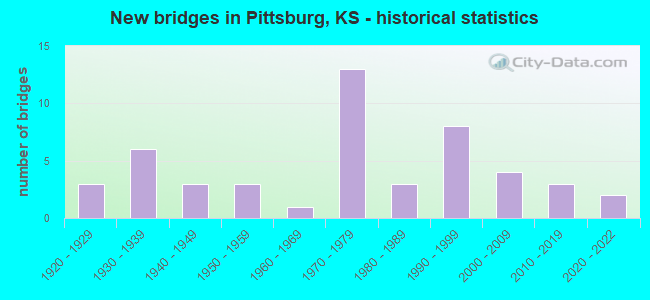
- New bridges - historical statistics
- 31920-1929
- 61930-1939
- 31940-1949
- 31950-1959
- 11960-1969
- 131970-1979
- 31980-1989
- 81990-1999
- 42000-2009
- 32010-2019
- 22020-2022
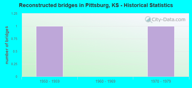
- Reconstructed bridges - Historical Statistics
- 11950-1959
- 01960-1969
- 11970-1979
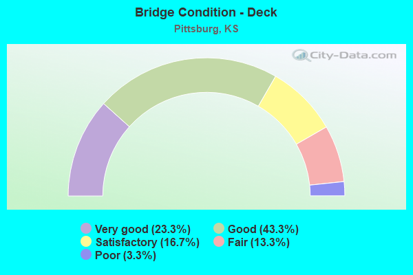
- Bridge Condition - Deck
- 23.3%Very good
- 43.3%Good
- 16.7%Satisfactory
- 13.3%Fair
- 3.3%Poor
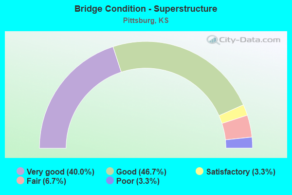
- Bridge Condition - Superstructure
- 40.0%Very good
- 46.7%Good
- 3.3%Satisfactory
- 6.7%Fair
- 3.3%Poor
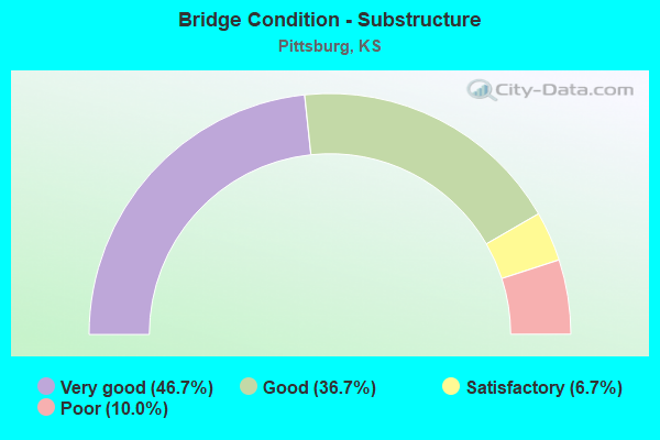
- Bridge Condition - Substructure
- 46.7%Very good
- 36.7%Good
- 6.7%Satisfactory
- 10.0%Poor
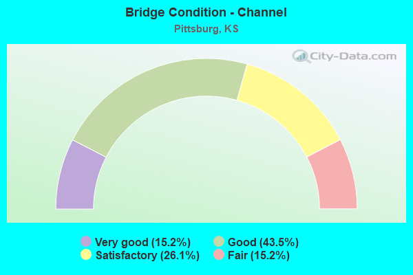
- Bridge Condition - Channel
- 15.2%Very good
- 43.5%Good
- 26.1%Satisfactory
- 15.2%Fair
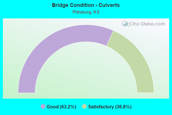
- Bridge Condition - Culverts
- 63.2%Good
- 36.8%Satisfactory
Find on map >> Show street view
Structure Number: 999912600191381, Location: 0.09 MI W US69 (Lat: 37.411111, Lng: -94.725556), Route carried "on" structure: State highway 126, Year Built: 2021, Status: Open, Structure Length: 7.40m (24.28ft), Average Daily Traffic: 4,912 (year 2020), Truck Traffic: 8%, Average Future Daily Traffic: 5,761 (year 2041), Design Load: HL 93, Features Intersected: MIDDLE COW CREEK
Minimum Vertical Clearance: 30.47m (99.97ft), Kilometerpoint: 33.711, Lanes on structure: 2, Owner: State Highway Agency, Approaching Roadway Width: 12.2m (40.0ft), Skew: 3 degrees, Material/Design: Prestressed concrete continuous, Design/Construction: Stringer/Multi-beam, Number Of Spans In Main Unit: 4, Length of Maximum Span: 21.3m (69.9ft), Curb-To-Curb Width: 17.1m (56.1ft), Out-to-Out Width: 17.7m (58.1ft)
Condition: Deck: Very good, Superstructure: Very good, Substructure: Very good, Channel: Very good, Operating Rating: 57.7 metric tons, Method Used To Determine Operating Rating: Load and Resistance Factor Rating (LRFR) rating reported by rating factor(RF) method using HL-93 loadings, Inventory Rating: 45.0 metric tons, Method Used To Determine Inventory Rating: Load and Resistance Factor Rating (LRFR) rating reported by rating factor(RF) method using HL-93 loadings, Structural Evaluation: Equal to present desirable criteria, Deck Geometry: Superior to present desirable criteria, Waterway Adequacy: Equal to present desirable criteria, Approach Roadway Alignment: Meets minimum limits, Length Of Structure Improvement: 24.29m (79.69ft), Designated Inspection Frequency: Every 24 months, Inspection Date: March 2021, Wearing Surface/Protective System: Wearing Surface: Monolithic Concrete, Deck Protection: Epoxy Coated Reinforcing
Find on map >> Show street view
Structure Number: 999917100110671, Location: 0.89 MI E JCT US69 (Lat: 37.338333, Lng: -94.689444), Route carried "on" structure: State highway 171, Year Built: 1971, Status: Open, Structure Length: 1.08m (3.54ft), Average Daily Traffic: 6,985 (year 2020), Truck Traffic: 18%, Average Future Daily Traffic: 10,379 (year 2041), Design Load: H 20, Features Intersected: LITTLE COW CREEK DRN
Minimum Vertical Clearance: 30.47m (99.97ft), Kilometerpoint: 1.440, Lanes on structure: 2, Base Highway Network: Yes, Owner: State Highway Agency, Approaching Roadway Width: 13.4m (44.0ft), Skew: 4 degrees, Material/Design: Concrete, Design/Construction: Culvert, Number Of Spans In Main Unit: 2, Length of Maximum Span: 3.7m (12.1ft), Curb-To-Curb Width: 13.4m (44.0ft), Out-to-Out Width: 19.0m (62.3ft)
Condition: Channel: Good, Culverts: Good, Operating Rating: 37.2 metric tons, Method Used To Determine Operating Rating: Load Factor (LF), Inventory Rating: 22.3 metric tons, Method Used To Determine Inventory Rating: Load Factor (LF), Structural Evaluation: Somewhat better than minimum adequacy, Deck Geometry: Equal to present minimum criteria, Waterway Adequacy: Better than present minimum criteria, Approach Roadway Alignment: Equal to present desirable criteria, Length Of Structure Improvement: 3.53m (11.58ft), Designated Inspection Frequency: Every 24 months, Inspection Date: Febuary 2020, Deck Structure Type: Concrete Cast-file-Place, Wearing Surface/Protective System: Wearing Surface: Bituminous
Find on map >> Show street view
Structure Number: 999917100110681, Location: 1.62 MI E JCT US69 (Lat: 37.338333, Lng: -94.675556), Route carried "on" structure: State highway 171, Year Built: 1972, Status: Open, Structure Length: 4.35m (14.27ft), Average Daily Traffic: 6,985 (year 2020), Truck Traffic: 18%, Average Future Daily Traffic: 10,379 (year 2041), Design Load: HS 20, Features Intersected: COW CREEK DRAINAGE
Minimum Vertical Clearance: 30.47m (99.97ft), Kilometerpoint: 2.620, Lanes on structure: 2, Base Highway Network: Yes, Owner: State Highway Agency, Approaching Roadway Width: 13.4m (44.0ft), Material/Design: Concrete continuous, Design/Construction: Slab, Number Of Spans In Main Unit: 4, Length of Maximum Span: 12.2m (40.0ft), Curb-To-Curb Width: 13.4m (44.0ft), Out-to-Out Width: 14.0m (45.9ft)
Condition: Deck: Good, Superstructure: Good, Substructure: Good, Channel: Good, Operating Rating: 55.3 metric tons, Method Used To Determine Operating Rating: Load Factor (LF), Inventory Rating: 33.6 metric tons, Method Used To Determine Inventory Rating: Load Factor (LF), Structural Evaluation: Better than present minimum criteria, Deck Geometry: Equal to present minimum criteria, Waterway Adequacy: Somewhat better than minimum adequacy, Approach Roadway Alignment: Equal to present desirable criteria, Length Of Structure Improvement: 14.26m (46.78ft), Designated Inspection Frequency: Every 24 months, Inspection Date: Febuary 2020, Deck Structure Type: Concrete Cast-file-Place, Wearing Surface/Protective System: Wearing Surface: Epoxy Overlay
Find on map >> Show street view
Structure Number: 999917100110691, Location: 1.72 MI E JCT US69 (Lat: 37.338333, Lng: -94.673889), Route carried "on" structure: State highway 171, Year Built: 1972, Status: Open, Structure Length: 9.59m (31.46ft), Average Daily Traffic: 6,985 (year 2020), Truck Traffic: 18%, Average Future Daily Traffic: 10,379 (year 2041), Design Load: HS 20, Features Intersected: COW CREEK
Minimum Vertical Clearance: 30.47m (99.97ft), Kilometerpoint: 2.776, Lanes on structure: 2, Base Highway Network: Yes, Owner: State Highway Agency, Approaching Roadway Width: 13.4m (44.0ft), Material/Design: Concrete continuous, Design/Construction: Tee Beam, Number Of Spans In Main Unit: 4, Length of Maximum Span: 27.7m (90.9ft), Curb-To-Curb Width: 13.4m (44.0ft), Out-to-Out Width: 14.0m (45.9ft)
Condition: Deck: Good, Superstructure: Good, Substructure: Good, Channel: Good, Operating Rating: 43.2 metric tons, Method Used To Determine Operating Rating: Load Factor (LF), Inventory Rating: 27.5 metric tons, Method Used To Determine Inventory Rating: Load Factor (LF), Structural Evaluation: Equal to present minimum criteria, Deck Geometry: Equal to present minimum criteria, Waterway Adequacy: Better than present minimum criteria, Approach Roadway Alignment: Equal to present desirable criteria, Length Of Structure Improvement: 31.46m (103.22ft), Designated Inspection Frequency: Every 24 months, Inspection Date: Febuary 2020, Deck Structure Type: Concrete Cast-file-Place, Wearing Surface/Protective System: Wearing Surface: Low Slump Concrete
Find on map >> Show street view
Structure Number: 999917100110701, Location: 3.20 MI E JCT US69 (Lat: 37.338056, Lng: -94.646944), Route carried "on" structure: State highway 171, Year Built: 1972, Status: Open, Structure Length: 5.26m (17.26ft), Average Daily Traffic: 6,985 (year 2020), Truck Traffic: 18%, Average Future Daily Traffic: 10,379 (year 2041), Design Load: HS 20, Features Intersected: KCS RAILROAD
Minimum Vertical Clearance: 30.47m (99.97ft), Kilometerpoint: 5.158, Lanes on structure: 2, Base Highway Network: Yes, Owner: State Highway Agency, Approaching Roadway Width: 13.4m (44.0ft), Skew: 2 degrees, Material/Design: Steel continuous, Design/Construction: Stringer/Multi-beam, Number Of Spans In Main Unit: 3, Length of Maximum Span: 19.8m (65.0ft), Curb-To-Curb Width: 13.4m (44.0ft), Out-to-Out Width: 14.0m (45.9ft)
Condition: Deck: Fair, Superstructure: Good, Substructure: Good, Operating Rating: 49.4 metric tons, Method Used To Determine Operating Rating: Load Factor (LF), Inventory Rating: 29.6 metric tons, Method Used To Determine Inventory Rating: Load Factor (LF), Structural Evaluation: Better than present minimum criteria, Deck Geometry: Equal to present minimum criteria, Underclear: Equal to present minimum criteria, Approach Roadway Alignment: Meets minimum limits, Length Of Structure Improvement: 17.27m (56.66ft), Designated Inspection Frequency: Every 24 months, Inspection Date: Febuary 2020, Deck Structure Type: Concrete Cast-file-Place, Wearing Surface/Protective System: Wearing Surface: Latex Concrete
Find on map >> Show street view
Structure Number: 999917100110711, Location: 3.71 MI E JCT US69 (Lat: 37.338333, Lng: -94.637778), Route carried "on" structure: State highway 171, Year Built: 1971, Status: Open, Structure Length: 3.13m (10.27ft), Average Daily Traffic: 6,985 (year 2020), Truck Traffic: 18%, Average Future Daily Traffic: 10,379 (year 2041), Design Load: HS 20, Features Intersected: TAYLOR CREEK
Minimum Vertical Clearance: 30.47m (99.97ft), Kilometerpoint: 5.975, Lanes on structure: 2, Base Highway Network: Yes, Owner: State Highway Agency, Approaching Roadway Width: 13.4m (44.0ft), Material/Design: Concrete continuous, Design/Construction: Slab, Number Of Spans In Main Unit: 3, Length of Maximum Span: 12.2m (40.0ft), Curb-To-Curb Width: 13.4m (44.0ft), Out-to-Out Width: 14.0m (45.9ft)
Condition: Deck: Satisfactory, Superstructure: Good, Substructure: Good, Channel: Fair, Operating Rating: 55.3 metric tons, Method Used To Determine Operating Rating: Load Factor (LF), Inventory Rating: 32.7 metric tons, Method Used To Determine Inventory Rating: Load Factor (LF), Structural Evaluation: Better than present minimum criteria, Deck Geometry: Equal to present minimum criteria, Waterway Adequacy: Equal to present minimum criteria, Approach Roadway Alignment: Equal to present desirable criteria, Length Of Structure Improvement: 10.26m (33.66ft), Designated Inspection Frequency: Every 24 months, Inspection Date: Febuary 2020, Deck Structure Type: Concrete Cast-file-Place, Wearing Surface/Protective System: Wearing Surface: Latex Concrete