Bridge Statistics for Plainfield, Indiana (IN)
Condition, Traffic, Stress, Structural Evaluation, Project Costs
- National Bridge Inventory (NBI) Statistics
- 86Number of bridges
- 784ft / 239mTotal length
- $2,606,000Total costs
- 1,133,978Total average daily traffic
- 135,854Total average daily truck traffic
- National Bridge Inventory (NBI) Registered Bridges for Plainfield
- No street view available for this location
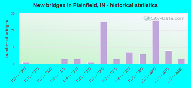
- New bridges - historical statistics
- 11900-1909
- 31930-1939
- 31940-1949
- 11950-1959
- 251960-1969
- 31970-1979
- 71980-1989
- 61990-1999
- 262000-2009
- 82010-2019
- 32020-2022
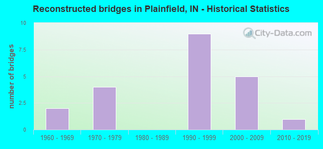
- Reconstructed bridges - Historical Statistics
- 21960-1969
- 41970-1979
- 01980-1989
- 91990-1999
- 52000-2009
- 12010-2019
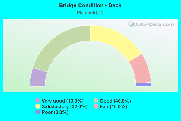
- Bridge Condition - Deck
- 10.0%Very good
- 40.0%Good
- 32.0%Satisfactory
- 16.0%Fair
- 2.0%Poor
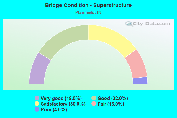
- Bridge Condition - Superstructure
- 18.0%Very good
- 32.0%Good
- 30.0%Satisfactory
- 16.0%Fair
- 4.0%Poor
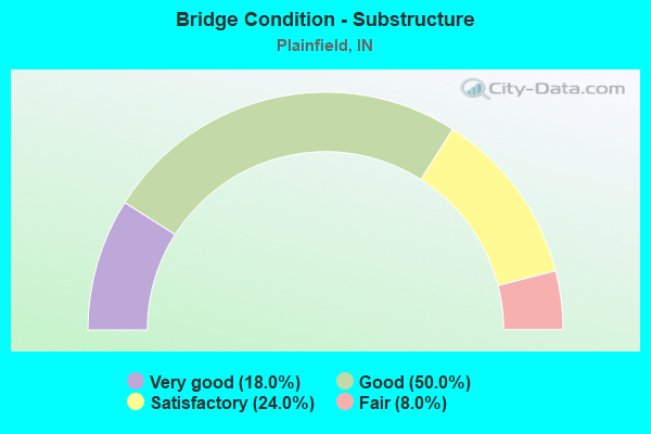
- Bridge Condition - Substructure
- 18.0%Very good
- 50.0%Good
- 24.0%Satisfactory
- 8.0%Fair
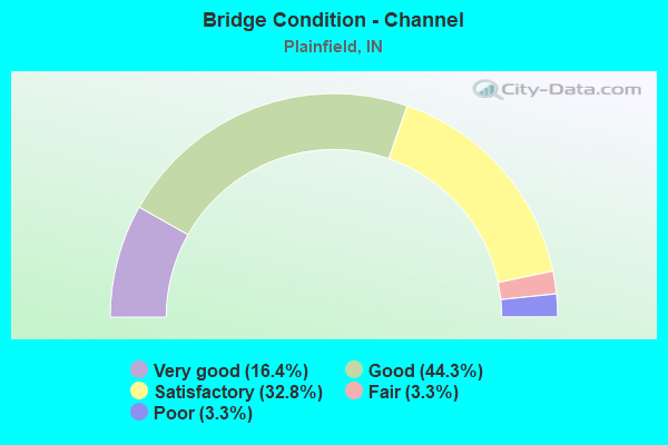
- Bridge Condition - Channel
- 16.4%Very good
- 44.3%Good
- 32.8%Satisfactory
- 3.3%Fair
- 3.3%Poor
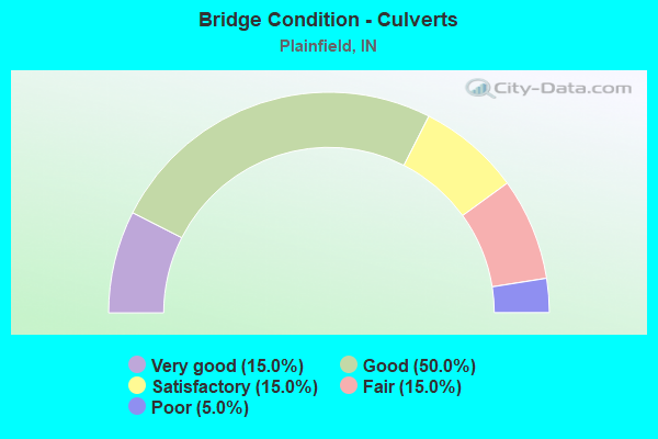
- Bridge Condition - Culverts
- 15.0%Very good
- 50.0%Good
- 15.0%Satisfactory
- 15.0%Fair
- 5.0%Poor
Find on map >> Show street view
Structure Number: 3200172, Location: 00.80 S OF CR 450 S (Lat: 39.688669, Lng: -86.335600), Route carried "on" structure: County highway 81, Year Built: 2004, Status: Open, Structure Length: 0.85m (2.79ft), Average Daily Traffic: 1,025 (year 2018), Truck Traffic: 15%, Average Future Daily Traffic: 1,675 (year 2038), Features Intersected: BR E FORK WHITE LICK CR, Facility Carried by Structure: CR 1050E
Minimum Vertical Clearance: 30+ m (98+ ft), Kilometerpoint: 0.000, Lanes on structure: 2, Owner: County Highway Agency, Approaching Roadway Width: 9.5m (31.2ft), Material/Design: Steel, Design/Construction: Culvert, Number Of Spans In Main Unit: 3, Length of Maximum Span: 2.7m (8.9ft), Curb-To-Curb Width: 9.5m (31.2ft), Out-to-Out Width: 34.7m (113.8ft)
Condition: Channel: Good, Culverts: Good, Operating Rating: 35.8 metric tons, Method Used To Determine Operating Rating: Load and Resistance Factor (LRFR), Inventory Rating: 27.6 metric tons, Method Used To Determine Inventory Rating: Load and Resistance Factor (LRFR), Structural Evaluation: Equal to present minimum criteria, Deck Geometry: Somewhat better than minimum adequacy, Waterway Adequacy: Equal to present desirable criteria, Approach Roadway Alignment: Equal to present desirable criteria, Designated Inspection Frequency: Every 24 months, Inspection Date: June 2020, Wearing Surface/Protective System: Wearing Surface: Bituminous
Find on map >> Show street view
Structure Number: 3200173, Location: 00.30 E OF CR 1025 E (Lat: 39.675700, Lng: -86.335550), Route carried "on" structure: County highway 522, Year Built: 1930, Status: Closed, Structure Length: 2.62m (8.60ft), Average Daily Traffic: 100 (year 2020), Truck Traffic: 6%, Average Future Daily Traffic: 125 (year 2040), Features Intersected: E FORK OF WHITE LICK CR, Facility Carried by Structure: CR 600S
Minimum Vertical Clearance: 30+ m (98+ ft), Kilometerpoint: 0.000, Lanes on structure: 1, Owner: County Highway Agency, Approaching Roadway Width: 5.2m (17.1ft), Material/Design: Concrete, Design/Construction: Culvert, Number Of Spans In Main Unit: 1, Length of Maximum Span: 24.4m (80.1ft), Curb-To-Curb Width: 5.5m (18.0ft), Out-to-Out Width: 6.1m (20.0ft)
Condition: Channel: Fair, Culverts: Poor, Deck Geometry: Meets minimum limits, Waterway Adequacy: Better than present minimum criteria, Approach Roadway Alignment: Equal to present minimum criteria, Bridge Posting: Required (Relationship of Operating Rating to Maximum Legal Load: > 39.9% below), Designated Inspection Frequency: Every 24 months, Inspection Date: May 2021, Wearing Surface/Protective System: Wearing Surface: Bituminous
Find on map >> Show street view
Structure Number: 3200174, Location: 00.05 N OF CR 700 S (Lat: 39.662119, Lng: -86.335850), Route carried "on" structure: County highway 151, Year Built: 1940, Status: Posted for load, Structure Length: 0.69m (2.26ft), Average Daily Traffic: 150 (year 2018), Truck Traffic: 6%, Average Future Daily Traffic: 500 (year 2038), Features Intersected: FLYNN CREEK, Facility Carried by Structure: CR 1050E
Minimum Vertical Clearance: 30+ m (98+ ft), Kilometerpoint: 0.000, Lanes on structure: 2, Owner: County Highway Agency, Approaching Roadway Width: 5.5m (18.0ft), Material/Design: Steel, Design/Construction: Stringer/Multi-beam, Number Of Spans In Main Unit: 1, Length of Maximum Span: 6.1m (20.0ft), Curb-To-Curb Width: 6.7m (22.0ft), Out-to-Out Width: 7.3m (24.0ft)
Condition: Deck: Satisfactory, Superstructure: Satisfactory, Substructure: Satisfactory, Channel: Satisfactory, Operating Rating: 93.7 metric tons, Method Used To Determine Operating Rating: Load Factor (LF), Inventory Rating: 56.1 metric tons, Method Used To Determine Inventory Rating: Load Factor (LF), Structural Evaluation: Equal to present minimum criteria, Deck Geometry: Meets minimum limits, Waterway Adequacy: Equal to present minimum criteria, Approach Roadway Alignment: Equal to present desirable criteria, Designated Inspection Frequency: Every 24 months, Inspection Date: June 2020, Deck Structure Type: Concrete Cast-file-Place, Wearing Surface/Protective System: Wearing Surface: Bituminous
Find on map >> Show street view
Structure Number: 3200175, Location: 00.25 W OF SR 267 (Lat: 39.682189, Lng: -86.375500), Route carried "on" structure: City street , Year Built: 2006, Status: Open, Structure Length: 1.54m (5.05ft), Average Daily Traffic: 750 (year 2018), Truck Traffic: 8%, Average Future Daily Traffic: 1,325 (year 2038), Features Intersected: CLARK'S CREEK, Facility Carried by Structure: WB CR 550S
Minimum Vertical Clearance: 30+ m (98+ ft), Kilometerpoint: 0.000, Lanes on structure: 2, Owner: County Highway Agency, Approaching Roadway Width: 8.0m (26.2ft), Material/Design: Concrete, Design/Construction: Culvert, Number Of Spans In Main Unit: 1, Length of Maximum Span: 14.6m (47.9ft), Curb or Sidewalk Widths: Left: 0.0m, Right: 1.8m (5.9ft), Curb-To-Curb Width: 8.0m (26.2ft), Out-to-Out Width: 14.5m (47.6ft)
Condition: Channel: Good, Culverts: Good, Operating Rating: 40.8 metric tons, Method Used To Determine Operating Rating: Field evaluation and documented engineering judgment, Inventory Rating: 32.7 metric tons, Method Used To Determine Inventory Rating: Field evaluation and documented engineering judgment, Structural Evaluation: Better than present minimum criteria, Deck Geometry: High priority of replacement, Waterway Adequacy: Equal to present desirable criteria, Approach Roadway Alignment: Equal to present desirable criteria, Designated Inspection Frequency: Every 24 months, Inspection Date: June 2020, Wearing Surface/Protective System: Wearing Surface: Bituminous
Find on map >> Show street view
Structure Number: 3200179, Location: 00.10 W OF SR 267 (Lat: 39.697150, Lng: -86.374119), Route carried "on" structure: City street , Year Built: 1968, Year Reconstructed: 1982, Status: Open, Structure Length: 2.64m (8.66ft), Average Daily Traffic: 7,250 (year 2018), Truck Traffic: 5%, Average Future Daily Traffic: 12,800 (year 2038), Design Load: HS 20, Features Intersected: CLARKS CREEK, Facility Carried by Structure: STAFFORD RD
Minimum Vertical Clearance: 30+ m (98+ ft), Kilometerpoint: 0.000, Lanes on structure: 3, Owner: County Highway Agency, Approaching Roadway Width: 11.0m (36.1ft), Material/Design: Concrete continuous, Design/Construction: Slab, Number Of Spans In Main Unit: 3, Length of Maximum Span: 10.2m (33.5ft), Curb or Sidewalk Widths: Left: 1.5m (4.9ft), Right: 0.0m, Curb-To-Curb Width: 12.2m (40.0ft), Out-to-Out Width: 14.3m (46.9ft)
Condition: Deck: Satisfactory, Superstructure: Satisfactory, Substructure: Good, Channel: Satisfactory, Operating Rating: 40.8 metric tons, Method Used To Determine Operating Rating: Field evaluation and documented engineering judgment, Inventory Rating: 32.7 metric tons, Method Used To Determine Inventory Rating: Field evaluation and documented engineering judgment, Structural Evaluation: Equal to present minimum criteria, Deck Geometry: Meets minimum limits, Waterway Adequacy: Better than present minimum criteria, Approach Roadway Alignment: Equal to present desirable criteria, Designated Inspection Frequency: Every 24 months, Inspection Date: June 2020, Deck Structure Type: Concrete Cast-file-Place, Wearing Surface/Protective System: Wearing Surface: Monolithic Concrete
Find on map >> Show street view
Structure Number: 320018, Location: 00.20 E OF SR 267 (Lat: 39.697231, Lng: -86.367939), Route carried "on" structure: City street , Year Built: 2000, Status: Open, Structure Length: 1.47m (4.82ft), Average Daily Traffic: 4,050 (year 2018), Truck Traffic: 15%, Average Future Daily Traffic: 7,125 (year 2038), Features Intersected: GEORGE CREEK, Facility Carried by Structure: CR 450S
Minimum Vertical Clearance: 30+ m (98+ ft), Kilometerpoint: 0.000, Lanes on structure: 4, Owner: County Highway Agency, Approaching Roadway Width: 7.6m (24.9ft), Skew: 24 degrees, Material/Design: Concrete, Design/Construction: Culvert, Number Of Spans In Main Unit: 1, Length of Maximum Span: 13.2m (43.3ft), Curb or Sidewalk Widths: Left: 0.0m, Right: 3.0m (9.8ft), Curb-To-Curb Width: 17.3m (56.8ft), Out-to-Out Width: 54.9m (180.1ft)
Condition: Channel: Good, Culverts: Good, Operating Rating: 40.8 metric tons, Method Used To Determine Operating Rating: Field evaluation and documented engineering judgment, Inventory Rating: 32.7 metric tons, Method Used To Determine Inventory Rating: Field evaluation and documented engineering judgment, Structural Evaluation: Better than present minimum criteria, Deck Geometry: Somewhat better than minimum adequacy, Waterway Adequacy: Better than present minimum criteria, Approach Roadway Alignment: Equal to present desirable criteria, Designated Inspection Frequency: Every 24 months, Inspection Date: June 2020, Wearing Surface/Protective System: Wearing Surface: Bituminous
Find on map >> Show street view
Structure Number: 3200181, Location: 00.40 E OF RONALD REAGAN (Lat: 39.697761, Lng: -86.328661), Route carried "on" structure: County highway 22, Year Built: 1900, Year Reconstructed: 1972, Status: Open, Structure Length: 2.41m (7.91ft), Average Daily Traffic: 5,500 (year 2020), Truck Traffic: 25%, Average Future Daily Traffic: 9,075 (year 2040), Design Load: HS 20, Features Intersected: E FORK OF WHITE LICK CR, Facility Carried by Structure: CR 450S
Minimum Vertical Clearance: 30+ m (98+ ft), Kilometerpoint: 0.000, Lanes on structure: 2, Owner: County Highway Agency, Approaching Roadway Width: 6.1m (20.0ft), Material/Design: Prestressed concrete, Design/Construction: Box Beam or Girders - Multiple, Number Of Spans In Main Unit: 1, Length of Maximum Span: 23.4m (76.8ft), Curb-To-Curb Width: 8.0m (26.2ft), Out-to-Out Width: 8.1m (26.6ft)
Condition: Deck: Poor, Superstructure: Poor, Substructure: Fair, Channel: Satisfactory, Operating Rating: 64.4 metric tons, Method Used To Determine Operating Rating: Load Factor (LF), Inventory Rating: 38.6 metric tons, Method Used To Determine Inventory Rating: Load Factor (LF), Structural Evaluation: Meets minimum limits, Deck Geometry: High priority of replacement, Waterway Adequacy: Equal to present desirable criteria, Approach Roadway Alignment: Equal to present minimum criteria, Length Of Structure Improvement: 3.35m (10.99ft), Designated Inspection Frequency: Every 12 months, Inspection Date: May 2021, Bridge Improvement Cost: $500,000, Roadway Improvement Cost: $350,000, Total Project Cost: $850,000 ( Estimate for 2020), Deck Structure Type: Concrete Precast Panels, Wearing Surface/Protective System: Wearing Surface: Bituminous
Find on map >> Show street view
Structure Number: 3200183, Location: 00.10 W OF SMITH RD (Lat: 39.733950, Lng: -86.362411), Route carried "on" structure: City street , Year Built: 1997, Status: Open, Structure Length: 0.91m (2.99ft), Average Daily Traffic: 2,525 (year 2018), Truck Traffic: 6%, Average Future Daily Traffic: 4,125 (year 2038), Design Load: HS 20, Features Intersected: CLARKS CREEK, Facility Carried by Structure: BRADFORD RD
Minimum Vertical Clearance: 30+ m (98+ ft), Kilometerpoint: 0.000, Lanes on structure: 2, Owner: County Highway Agency, Approaching Roadway Width: 11.0m (36.1ft), Material/Design: Concrete, Design/Construction: Culvert, Number Of Spans In Main Unit: 1, Length of Maximum Span: 8.4m (27.6ft), Curb-To-Curb Width: 11.8m (38.7ft), Out-to-Out Width: 12.8m (42.0ft)
Condition: Channel: Good, Culverts: Satisfactory, Operating Rating: 40.8 metric tons, Method Used To Determine Operating Rating: Field evaluation and documented engineering judgment, Inventory Rating: 32.7 metric tons, Method Used To Determine Inventory Rating: Field evaluation and documented engineering judgment, Structural Evaluation: Equal to present minimum criteria, Deck Geometry: Somewhat better than minimum adequacy, Waterway Adequacy: Better than present minimum criteria, Approach Roadway Alignment: Equal to present desirable criteria, Designated Inspection Frequency: Every 24 months, Inspection Date: June 2020, Wearing Surface/Protective System: Wearing Surface: Bituminous
Find on map >> Show street view
Structure Number: 3200186, Location: 00.20 N OF CR 300 S (Lat: 39.722769, Lng: -86.380919), Route carried "on" structure: City street , Year Built: 1940, Year Reconstructed: 1970, Status: Posted for load, Structure Length: 0.96m (3.15ft), Average Daily Traffic: 15,550 (year 2018), Truck Traffic: 5%, Average Future Daily Traffic: 25,275 (year 2038), Features Intersected: BRANCH OF CLARKS CREEK, Facility Carried by Structure: DAN JONES RD
Minimum Vertical Clearance: 30+ m (98+ ft), Kilometerpoint: 0.000, Lanes on structure: 2, Owner: County Highway Agency, Approaching Roadway Width: 9.1m (29.9ft), Skew: 4 degrees, Material/Design: Concrete, Design/Construction: Culvert, Number Of Spans In Main Unit: 1, Length of Maximum Span: 9.3m (30.5ft), Curb-To-Curb Width: 9.8m (32.2ft), Out-to-Out Width: 9.9m (32.5ft)
Condition: Channel: Poor, Culverts: Fair, Operating Rating: 13.6 metric tons, Method Used To Determine Operating Rating: Field evaluation and documented engineering judgment, Inventory Rating: 13.6 metric tons, Method Used To Determine Inventory Rating: Field evaluation and documented engineering judgment, Structural Evaluation: High priority of corrective action, Deck Geometry: Meets minimum limits, Waterway Adequacy: Better than present minimum criteria, Approach Roadway Alignment: Equal to present desirable criteria, Bridge Posting: Required (Relationship of Operating Rating to Maximum Legal Load: > 39.9% below), Designated Inspection Frequency: Every 24 months, Inspection Date: June 2020, Wearing Surface/Protective System: Wearing Surface: Bituminous
Find on map >> Show street view
Structure Number: 3200187, Location: 00.40 N OF CR 300 S (Lat: 39.724061, Lng: -86.380900), Route carried "on" structure: City street , Year Built: 1940, Year Reconstructed: 1970, Status: Open, Structure Length: 0.68m (2.23ft), Average Daily Traffic: 15,550 (year 2018), Truck Traffic: 5%, Average Future Daily Traffic: 25,275 (year 2038), Features Intersected: BRANCH OF CLARKS CREEK, Facility Carried by Structure: DAN JONES RD
Minimum Vertical Clearance: 30+ m (98+ ft), Kilometerpoint: 0.000, Lanes on structure: 2, Owner: County Highway Agency, Approaching Roadway Width: 9.1m (29.9ft), Skew: 2 degrees, Material/Design: Concrete, Design/Construction: Slab, Number Of Spans In Main Unit: 1, Length of Maximum Span: 6.1m (20.0ft), Curb-To-Curb Width: 9.7m (31.8ft), Out-to-Out Width: 9.8m (32.2ft)
Condition: Deck: Fair, Superstructure: Fair, Substructure: Fair, Channel: Satisfactory, Operating Rating: 32.7 metric tons, Method Used To Determine Operating Rating: Field evaluation and documented engineering judgment, Inventory Rating: 26.3 metric tons, Method Used To Determine Inventory Rating: Field evaluation and documented engineering judgment, Structural Evaluation: Somewhat better than minimum adequacy, Deck Geometry: High priority of corrective action, Waterway Adequacy: Better than present minimum criteria, Approach Roadway Alignment: Equal to present desirable criteria, Designated Inspection Frequency: Every 24 months, Inspection Date: June 2020, Deck Structure Type: Concrete Cast-file-Place, Wearing Surface/Protective System: Wearing Surface: Bituminous
Find on map >> Show street view
Structure Number: 3200189, Location: 00.05 E OF CR 600 E (Lat: 39.718539, Lng: -86.417781), Route carried "on" structure: City street , Year Built: 1984, Status: Open, Structure Length: 5.73m (18.80ft), Average Daily Traffic: 4,875 (year 2018), Truck Traffic: 5%, Average Future Daily Traffic: 8,650 (year 2038), Design Load: HS 20, Features Intersected: WHITE LICK CREEK, Facility Carried by Structure: CR 300S
Minimum Vertical Clearance: 30+ m (98+ ft), Kilometerpoint: 0.000, Lanes on structure: 2, Owner: County Highway Agency, Approaching Roadway Width: 6.1m (20.0ft), Material/Design: Prestressed concrete continuous, Design/Construction: Box Beam or Girders - Single/Spread, Number Of Spans In Main Unit: 3, Length of Maximum Span: 18.8m (61.7ft), Curb-To-Curb Width: 9.0m (29.5ft), Out-to-Out Width: 9.6m (31.5ft)
Condition: Deck: Good, Superstructure: Good, Substructure: Good, Channel: Satisfactory, Operating Rating: 40.9 metric tons, Method Used To Determine Operating Rating: Load Factor (LF), Inventory Rating: 24.5 metric tons, Method Used To Determine Inventory Rating: Load Factor (LF), Structural Evaluation: Equal to present minimum criteria, Deck Geometry: Meets minimum limits, Waterway Adequacy: Equal to present desirable criteria, Approach Roadway Alignment: Equal to present minimum criteria, Designated Inspection Frequency: Every 24 months, Inspection Date: June 2020, Deck Structure Type: Concrete Cast-file-Place, Wearing Surface/Protective System: Wearing Surface: Monolithic Concrete
Find on map >> Show street view
Structure Number: 3200197, Location: 00.10 E OF GATERSBURG (Lat: 39.699600, Lng: -86.461589), Route carried "on" structure: County highway 163, Year Built: 1988, Status: Open, Structure Length: 5.34m (17.52ft), Average Daily Traffic: 300 (year 2018), Truck Traffic: 5%, Average Future Daily Traffic: 475 (year 2038), Design Load: HS 20, Features Intersected: W FORK OF WHITE LICK CR, Facility Carried by Structure: CR 425E
Minimum Vertical Clearance: 30+ m (98+ ft), Kilometerpoint: 0.000, Lanes on structure: 2, Owner: County Highway Agency, Approaching Roadway Width: 6.4m (21.0ft), Skew: 1 degrees, Material/Design: Steel continuous, Design/Construction: Stringer/Multi-beam, Number Of Spans In Main Unit: 3, Length of Maximum Span: 19.8m (65.0ft), Curb-To-Curb Width: 9.0m (29.5ft), Out-to-Out Width: 9.8m (32.2ft)
Condition: Deck: Good, Superstructure: Good, Substructure: Good, Channel: Satisfactory, Operating Rating: 40.8 metric tons, Method Used To Determine Operating Rating: Field evaluation and documented engineering judgment, Inventory Rating: 32.7 metric tons, Method Used To Determine Inventory Rating: Field evaluation and documented engineering judgment, Structural Evaluation: Better than present minimum criteria, Deck Geometry: Equal to present minimum criteria, Waterway Adequacy: Equal to present desirable criteria, Approach Roadway Alignment: Equal to present desirable criteria, Designated Inspection Frequency: Every 24 months, Inspection Date: June 2020, Deck Structure Type: Concrete Cast-file-Place, Wearing Surface/Protective System: Wearing Surface: Monolithic Concrete, Deck Protection: Epoxy Coated Reinforcing
Find on map >> Show street view
Structure Number: 3200198, Location: 00.20 W OF CR 425 E (Lat: 39.704650, Lng: -86.456931), Route carried "on" structure: County highway 163, Year Built: 1987, Status: Open, Structure Length: 3.17m (10.40ft), Average Daily Traffic: 300 (year 2018), Truck Traffic: 5%, Average Future Daily Traffic: 475 (year 2038), Design Load: HS 20, Features Intersected: COSNER BRANCH, Facility Carried by Structure: CR 425E
Minimum Vertical Clearance: 30+ m (98+ ft), Kilometerpoint: 0.000, Lanes on structure: 2, Owner: County Highway Agency, Approaching Roadway Width: 7.3m (24.0ft), Skew: 2 degrees, Material/Design: Concrete continuous, Design/Construction: Slab, Number Of Spans In Main Unit: 3, Length of Maximum Span: 11.9m (39.0ft), Curb-To-Curb Width: 8.5m (27.9ft), Out-to-Out Width: 9.4m (30.8ft)
Condition: Deck: Good, Superstructure: Good, Substructure: Good, Channel: Satisfactory, Operating Rating: 68.7 metric tons, Method Used To Determine Operating Rating: Load Factor (LF), Inventory Rating: 41.1 metric tons, Method Used To Determine Inventory Rating: Load Factor (LF), Structural Evaluation: Better than present minimum criteria, Deck Geometry: Equal to present minimum criteria, Waterway Adequacy: Better than present minimum criteria, Approach Roadway Alignment: Equal to present minimum criteria, Designated Inspection Frequency: Every 24 months, Inspection Date: June 2020, Deck Structure Type: Concrete Cast-file-Place, Wearing Surface/Protective System: Wearing Surface: Monolithic Concrete, Deck Protection: Epoxy Coated Reinforcing
Find on map >> Show street view
Structure Number: 3200213, Location: 00.30 N SR 267 (Lat: 39.657569, Lng: -86.383300), Route carried "on" structure: County highway 267, Year Built: 1997, Status: Open, Structure Length: 3.71m (12.17ft), Average Daily Traffic: 5,875 (year 2018), Truck Traffic: 15%, Average Future Daily Traffic: 9,675 (year 2038), Design Load: HS 20, Features Intersected: CLARKS CREEK
Minimum Vertical Clearance: 30+ m (98+ ft), Kilometerpoint: 0.000, Lanes on structure: 2, Owner: County Highway Agency, Approaching Roadway Width: 7.3m (24.0ft), Skew: 3 degrees, Material/Design: Concrete continuous, Design/Construction: Slab, Number Of Spans In Main Unit: 3, Length of Maximum Span: 14.6m (47.9ft), Curb-To-Curb Width: 13.4m (44.0ft), Out-to-Out Width: 14.2m (46.6ft)
Condition: Deck: Satisfactory, Superstructure: Satisfactory, Substructure: Very good, Channel: Good, Operating Rating: 57.9 metric tons, Method Used To Determine Operating Rating: Load Factor (LF), Inventory Rating: 34.6 metric tons, Method Used To Determine Inventory Rating: Load Factor (LF), Structural Evaluation: Equal to present minimum criteria, Deck Geometry: Equal to present minimum criteria, Waterway Adequacy: Better than present minimum criteria, Approach Roadway Alignment: Equal to present desirable criteria, Designated Inspection Frequency: Every 24 months, Inspection Date: June 2020, Deck Structure Type: Concrete Cast-file-Place, Wearing Surface/Protective System: Wearing Surface: Monolithic Concrete, Deck Protection: Epoxy Coated Reinforcing
Find on map >> Show street view
Structure Number: 320022, Location: 00.10 N OF CR 900 N (Lat: 39.894319, Lng: -86.524733), Route carried "on" structure: County highway , Year Built: 1987, Status: Open, Structure Length: 0.79m (2.59ft), Average Daily Traffic: 425 (year 2020), Truck Traffic: 5%, Average Future Daily Traffic: 650 (year 2040), Features Intersected: ARMSTRONG, Facility Carried by Structure: CR 00E/W
Minimum Vertical Clearance: 30+ m (98+ ft), Kilometerpoint: 0.000, Lanes on structure: 2, Owner: County Highway Agency, Approaching Roadway Width: 5.5m (18.0ft), Material/Design: Wood or Timber, Design/Construction: Slab, Number Of Spans In Main Unit: 1, Length of Maximum Span: 7.3m (24.0ft), Curb or Sidewalk Widths: Left: 0.2m (0.7ft), Right: 0.2m (0.7ft), Curb-To-Curb Width: 7.4m (24.3ft), Out-to-Out Width: 7.8m (25.6ft)
Condition: Deck: Satisfactory, Superstructure: Satisfactory, Substructure: Satisfactory, Channel: Satisfactory, Operating Rating: 56.2 metric tons, Method Used To Determine Operating Rating: Load and Resistance Factor (LRFR), Inventory Rating: 43.4 metric tons, Method Used To Determine Inventory Rating: Load and Resistance Factor (LRFR), Structural Evaluation: Equal to present minimum criteria, Deck Geometry: Meets minimum limits, Waterway Adequacy: Better than present minimum criteria, Approach Roadway Alignment: Equal to present minimum criteria, Designated Inspection Frequency: Every 24 months, Inspection Date: June 2020, Deck Structure Type: Wood or Timber, Wearing Surface/Protective System: Wearing Surface: Bituminous, Deck Protection: Internally Sealed
Find on map >> Show street view
Structure Number: 3200221, Location: 00.10 N OF CR 600 S (Lat: 39.675239, Lng: -86.391350), Route carried "on" structure: City street , Year Built: 1987, Status: Open, Structure Length: 3.48m (11.42ft), Average Daily Traffic: 275 (year 2018), Truck Traffic: 6%, Average Future Daily Traffic: 300 (year 2038), Features Intersected: CRYSTAL BAY OVERFLOW, Facility Carried by Structure: CRYSTAL BAY,W DR
Minimum Vertical Clearance: 30+ m (98+ ft), Kilometerpoint: 0.000, Lanes on structure: 2, Owner: County Highway Agency, Approaching Roadway Width: 7.9m (25.9ft), Material/Design: Wood or Timber, Design/Construction: Slab, Number Of Spans In Main Unit: 5, Length of Maximum Span: 7.9m (25.9ft), Curb or Sidewalk Widths: Left: 0.2m (0.7ft), Right: 1.8m (5.9ft), Curb-To-Curb Width: 7.4m (24.3ft), Out-to-Out Width: 9.3m (30.5ft)
Condition: Deck: Satisfactory, Superstructure: Satisfactory, Substructure: Good, Channel: Good, Operating Rating: 61.1 metric tons, Method Used To Determine Operating Rating: Load and Resistance Factor (LRFR), Inventory Rating: 47.0 metric tons, Method Used To Determine Inventory Rating: Load and Resistance Factor (LRFR), Structural Evaluation: Equal to present minimum criteria, Deck Geometry: Somewhat better than minimum adequacy, Waterway Adequacy: Equal to present desirable criteria, Approach Roadway Alignment: Equal to present desirable criteria, Designated Inspection Frequency: Every 24 months, Inspection Date: June 2020, Deck Structure Type: Wood or Timber, Wearing Surface/Protective System: Wearing Surface: Bituminous, Deck Protection: Internally Sealed
Find on map >> Show street view
Structure Number: 3200229, Location: 00.10 E OF SR 267 (Lat: 39.688361, Lng: -86.366500), Route carried "on" structure: City street , Year Built: 1993, Status: Open, Structure Length: 0.66m (2.17ft), Average Daily Traffic: 250 (year 2018), Truck Traffic: 15%, Average Future Daily Traffic: 375 (year 2038), Features Intersected: ROGERS CREEK, Facility Carried by Structure: AIRWEST BLVD
Minimum Vertical Clearance: 30+ m (98+ ft), Kilometerpoint: 0.000, Lanes on structure: 2, Owner: County Highway Agency, Approaching Roadway Width: 9.4m (30.8ft), Material/Design: Concrete, Design/Construction: Culvert, Number Of Spans In Main Unit: 1, Length of Maximum Span: 6.1m (20.0ft), Curb-To-Curb Width: 9.4m (30.8ft), Out-to-Out Width: 21.9m (71.9ft)
Condition: Channel: Satisfactory, Culverts: Fair, Operating Rating: 40.8 metric tons, Method Used To Determine Operating Rating: Field evaluation and documented engineering judgment, Inventory Rating: 32.7 metric tons, Method Used To Determine Inventory Rating: Field evaluation and documented engineering judgment, Structural Evaluation: Somewhat better than minimum adequacy, Deck Geometry: Equal to present minimum criteria, Waterway Adequacy: Better than present minimum criteria, Approach Roadway Alignment: Equal to present desirable criteria, Designated Inspection Frequency: Every 24 months, Inspection Date: June 2020, Wearing Surface/Protective System: Wearing Surface: Bituminous
Find on map >> Show street view
Structure Number: 3200251, Location: 00.50 N OF CR 200 S (Lat: 39.740781, Lng: -86.381019), Route carried "on" structure: City street , Year Built: 1999, Status: Open, Structure Length: 1.00m (3.28ft), Average Daily Traffic: 15,850 (year 2020), Truck Traffic: 5%, Average Future Daily Traffic: 26,125 (year 2040), Design Load: HS 20, Features Intersected: CLARKS CREEK, Facility Carried by Structure: DAN JONES RD
Minimum Vertical Clearance: 30+ m (98+ ft), Kilometerpoint: 0.000, Lanes on structure: 2, Owner: County Highway Agency, Approaching Roadway Width: 10.1m (33.1ft), Skew: 2 degrees, Material/Design: Concrete, Design/Construction: Culvert, Number Of Spans In Main Unit: 1, Length of Maximum Span: 9.4m (30.8ft), Curb-To-Curb Width: 15.1m (49.5ft), Out-to-Out Width: 26.9m (88.3ft)
Condition: Channel: Good, Culverts: Good, Operating Rating: 40.8 metric tons, Method Used To Determine Operating Rating: Field evaluation and documented engineering judgment, Inventory Rating: 32.7 metric tons, Method Used To Determine Inventory Rating: Field evaluation and documented engineering judgment, Structural Evaluation: Better than present minimum criteria, Deck Geometry: Superior to present desirable criteria, Waterway Adequacy: Better than present minimum criteria, Approach Roadway Alignment: Equal to present desirable criteria, Designated Inspection Frequency: Every 24 months, Inspection Date: June 2020, Wearing Surface/Protective System: Wearing Surface: Bituminous
Find on map >> Show street view
Structure Number: 3200257, Location: 00.01 E OF SR 267 (Lat: 39.682381, Lng: -86.370350), Route carried "on" structure: City street , Year Built: 2015, Status: Open, Structure Length: 0.77m (2.53ft), Average Daily Traffic: 750 (year 2018), Truck Traffic: 8%, Average Future Daily Traffic: 1,325 (year 2038), Design Load: HL 93, Features Intersected: ROGERS CREEK, Facility Carried by Structure: REEVES RD
Minimum Vertical Clearance: 30+ m (98+ ft), Kilometerpoint: 0.000, Lanes on structure: 3, Owner: County Highway Agency, Approaching Roadway Width: 11.0m (36.1ft), Material/Design: Concrete, Design/Construction: Culvert, Number Of Spans In Main Unit: 1, Length of Maximum Span: 7.3m (24.0ft), Curb-To-Curb Width: 12.1m (39.7ft), Out-to-Out Width: 20.1m (65.9ft)
Condition: Channel: Satisfactory, Culverts: Satisfactory, Operating Rating: 40.8 metric tons, Method Used To Determine Operating Rating: Field evaluation and documented engineering judgment, Inventory Rating: 32.7 metric tons, Method Used To Determine Inventory Rating: Field evaluation and documented engineering judgment, Structural Evaluation: Equal to present minimum criteria, Deck Geometry: Meets minimum limits, Waterway Adequacy: Better than present minimum criteria, Approach Roadway Alignment: Equal to present desirable criteria, Designated Inspection Frequency: Every 24 months, Inspection Date: June 2020, Wearing Surface/Protective System: Wearing Surface: Bituminous
Find on map >> Show street view
Structure Number: 3200258, Location: 00.05 W OF SR 267 (Lat: 39.689889, Lng: -86.371411), Route carried "on" structure: City street , Year Built: 2015, Status: Open, Structure Length: 0.65m (2.13ft), Average Daily Traffic: 1,350 (year 2018), Truck Traffic: 16%, Average Future Daily Traffic: 1,925 (year 2038), Design Load: HL 93, Features Intersected: GEORGE CREEK, Facility Carried by Structure: STANLEY RD
Minimum Vertical Clearance: 30+ m (98+ ft), Kilometerpoint: 0.000, Lanes on structure: 5, Owner: County Highway Agency, Approaching Roadway Width: 18.3m (60.0ft), Material/Design: Concrete, Design/Construction: Culvert, Number Of Spans In Main Unit: 1, Length of Maximum Span: 6.1m (20.0ft), Curb or Sidewalk Widths: Left: 5.2m (17.1ft), Right: 5.2m (17.1ft), Curb-To-Curb Width: 20.4m (66.9ft), Out-to-Out Width: 31.7m (104.0ft)
Condition: Channel: Satisfactory, Culverts: Good, Operating Rating: 40.8 metric tons, Method Used To Determine Operating Rating: Field evaluation and documented engineering judgment, Inventory Rating: 32.7 metric tons, Method Used To Determine Inventory Rating: Field evaluation and documented engineering judgment, Structural Evaluation: Better than present minimum criteria, Deck Geometry: Somewhat better than minimum adequacy, Waterway Adequacy: Equal to present desirable criteria, Approach Roadway Alignment: Equal to present desirable criteria, Designated Inspection Frequency: Every 24 months, Inspection Date: June 2020, Wearing Surface/Protective System: Wearing Surface: Bituminous
Find on map >> Show street view
Structure Number: 3200263, Location: 00.05 N CR 200 S (Lat: 39.734589, Lng: -86.361339), Route carried "on" structure: City street , Year Built: 2016, Status: Open, Structure Length: 1.15m (3.77ft), Average Daily Traffic: 750 (year 2018), Average Future Daily Traffic: 1,250 (year 2038), Design Load: HL 93, Features Intersected: CLARKS CREEK, Facility Carried by Structure: SMITH RD
Minimum Vertical Clearance: 30+ m (98+ ft), Kilometerpoint: 0.000, Lanes on structure: 2, Owner: County Highway Agency, Approaching Roadway Width: 13.7m (44.9ft), Skew: 2 degrees, Material/Design: Concrete, Design/Construction: Culvert, Number Of Spans In Main Unit: 1, Length of Maximum Span: 11.0m (36.1ft), Curb or Sidewalk Widths: Left: 2.6m (8.5ft), Right: 0.0m, Curb-To-Curb Width: 14.4m (47.2ft), Out-to-Out Width: 26.2m (86.0ft)
Condition: Channel: Very good, Culverts: Very good, Operating Rating: 40.8 metric tons, Method Used To Determine Operating Rating: Field evaluation and documented engineering judgment, Inventory Rating: 32.7 metric tons, Method Used To Determine Inventory Rating: Field evaluation and documented engineering judgment, Structural Evaluation: Equal to present desirable criteria, Deck Geometry: Superior to present desirable criteria, Waterway Adequacy: Better than present minimum criteria, Approach Roadway Alignment: Equal to present desirable criteria, Designated Inspection Frequency: Every 24 months, Inspection Date: June 2020, Wearing Surface/Protective System: Wearing Surface: Bituminous
Find on map >> Show street view
Structure Number: 3200265, Location: 0.20 E of CR 900 E (Lat: 39.741389, Lng: -86.358931), Route carried "on" structure: City street , Year Built: 2016, Status: Open, Structure Length: 0.91m (2.99ft), Average Daily Traffic: 500 (year 2018), Truck Traffic: 15%, Average Future Daily Traffic: 750 (year 2038), Design Load: HL 93, Features Intersected: CLARKS CREEK, Facility Carried by Structure: ALL POINTS PKWY
Minimum Vertical Clearance: 30+ m (98+ ft), Kilometerpoint: 0.000, Lanes on structure: 2, Owner: County Highway Agency, Approaching Roadway Width: 11.9m (39.0ft), Skew: 1 degrees, Material/Design: Concrete, Design/Construction: Culvert, Number Of Spans In Main Unit: 2, Length of Maximum Span: 8.5m (27.9ft), Curb or Sidewalk Widths: Left: 0.0m, Right: 2.6m (8.5ft), Curb-To-Curb Width: 11.9m (39.0ft), Out-to-Out Width: 18.2m (59.7ft)
Condition: Channel: Very good, Culverts: Very good, Operating Rating: 40.8 metric tons, Method Used To Determine Operating Rating: Field evaluation and documented engineering judgment, Inventory Rating: 32.7 metric tons, Method Used To Determine Inventory Rating: Field evaluation and documented engineering judgment, Structural Evaluation: Equal to present desirable criteria, Deck Geometry: Better than present minimum criteria, Waterway Adequacy: Better than present minimum criteria, Approach Roadway Alignment: Equal to present desirable criteria, Designated Inspection Frequency: Every 24 months, Inspection Date: June 2020, Wearing Surface/Protective System: Wearing Surface: Bituminous
Find on map >> Show street view
Structure Number: 320028, Location: 0.20 W of SR 267 (Lat: 39.788750, Lng: -86.404981), Route carried "on" structure: County highway 64, Year Built: 2018, Status: Open, Structure Length: 1.11m (3.64ft), Average Daily Traffic: 50 (year 2020), Truck Traffic: 2%, Average Future Daily Traffic: 60 (year 2040), Design Load: HL 93, Features Intersected: BRANCH OF WHITE LICK CR, Facility Carried by Structure: CR 151 N
Minimum Vertical Clearance: 30+ m (98+ ft), Kilometerpoint: 0.000, Lanes on structure: 2, Owner: County Highway Agency, Approaching Roadway Width: 7.3m (24.0ft), Skew: 4 degrees, Material/Design: Concrete, Design/Construction: Culvert, Number Of Spans In Main Unit: 1, Length of Maximum Span: 10.3m (33.8ft), Curb-To-Curb Width: 10.4m (34.1ft), Out-to-Out Width: 14.0m (45.9ft)
Condition: Channel: Very good, Culverts: Good, Operating Rating: 40.8 metric tons, Method Used To Determine Operating Rating: Field evaluation and documented engineering judgment, Inventory Rating: 32.7 metric tons, Method Used To Determine Inventory Rating: Field evaluation and documented engineering judgment, Structural Evaluation: Better than present minimum criteria, Deck Geometry: Superior to present desirable criteria, Waterway Adequacy: Better than present minimum criteria, Approach Roadway Alignment: Equal to present desirable criteria, Designated Inspection Frequency: Every 24 months, Inspection Date: June 2020, Wearing Surface/Protective System: Wearing Surface: Bituminous
Find on map >> Show street view
Structure Number: 3200284, Location: 00.30 W OF CR 975 E (Lat: 39.653439, Lng: -86.355100), Route carried "on" structure: County highway 90, Year Built: 2020, Status: Open, Structure Length: 0.62m (2.03ft), Average Daily Traffic: 5,000 (year 2018), Truck Traffic: 10%, Average Future Daily Traffic: 7,000 (year 2038), Design Load: HS 20, Features Intersected: BR W FORK HENDRICKS CR, Facility Carried by Structure: CR 750S
Minimum Vertical Clearance: 30+ m (98+ ft), Kilometerpoint: 0.000, Lanes on structure: 2, Owner: County Highway Agency, Approaching Roadway Width: 6.1m (20.0ft), Material/Design: Concrete, Design/Construction: Culvert, Number Of Spans In Main Unit: 1, Length of Maximum Span: 6.1m (20.0ft), Curb-To-Curb Width: 12.2m (40.0ft), Out-to-Out Width: 17.1m (56.1ft)
Condition: Channel: Very good, Culverts: Very good, Operating Rating: 32.7 metric tons, Method Used To Determine Operating Rating: Field evaluation and documented engineering judgment, Inventory Rating: 32.7 metric tons, Method Used To Determine Inventory Rating: Field evaluation and documented engineering judgment, Structural Evaluation: Equal to present desirable criteria, Deck Geometry: Equal to present minimum criteria, Waterway Adequacy: Better than present minimum criteria, Approach Roadway Alignment: Equal to present desirable criteria, Designated Inspection Frequency: Every 24 months, Inspection Date: June 2020, Wearing Surface/Protective System: Wearing Surface: Bituminous
Find on map >> Show street view
Structure Number: 3200285, Location: 00.50 W OF SR 267 (Lat: 39.689239, Lng: -86.379481), Route carried "on" structure: City street , Year Built: 2020, Status: Open, Structure Length: 4.41m (14.47ft), Average Daily Traffic: 1,275 (year 2020), Truck Traffic: 5%, Average Future Daily Traffic: 1,900 (year 2040), Design Load: HL 93, Features Intersected: CLARKS CREEK, Facility Carried by Structure: STANLEY ROAD
Minimum Vertical Clearance: 30+ m (98+ ft), Kilometerpoint: 0.000, Lanes on structure: 2, Owner: County Highway Agency, Approaching Roadway Width: 7.3m (24.0ft), Skew: 1 degrees, Material/Design: Prestressed concrete continuous, Design/Construction: Tee Beam, Number Of Spans In Main Unit: 2, Length of Maximum Span: 21.9m (71.9ft), Curb or Sidewalk Widths: Left: 1.8m (5.9ft), Right: 0.0m, Curb-To-Curb Width: 8.5m (27.9ft), Out-to-Out Width: 11.3m (37.1ft)
Condition: Deck: Very good, Superstructure: Very good, Substructure: Very good, Channel: Very good, Inventory Rating: 77.5 metric tons, Method Used To Determine Inventory Rating: Load and Resistance Factor (LRFR), Structural Evaluation: Equal to present desirable criteria, Deck Geometry: Somewhat better than minimum adequacy, Waterway Adequacy: Better than present minimum criteria, Approach Roadway Alignment: Equal to present minimum criteria, Designated Inspection Frequency: Every 24 months, Inspection Date: May 2020, Deck Structure Type: Concrete Cast-file-Place, Wearing Surface/Protective System: Wearing Surface: Monolithic Concrete, Deck Protection: Epoxy Coated Reinforcing
Find on map >> Show street view
Structure Number: 3200302, Location: 00.50 S OF CR 700 S (Lat: 39.651719, Lng: -86.462550), Route carried "on" structure: County highway 131, Year Built: 2021, Status: Open, Structure Length: 1.01m (3.31ft), Average Daily Traffic: 400 (year 2021), Truck Traffic: 6%, Average Future Daily Traffic: 600 (year 2041), Design Load: HS 20, Features Intersected: BRANCH OF MCCRACKEN CR, Facility Carried by Structure: CR 375E
Minimum Vertical Clearance: 30+ m (98+ ft), Kilometerpoint: 0.000, Lanes on structure: 2, Owner: County Highway Agency, Approaching Roadway Width: 5.5m (18.0ft), Material/Design: Concrete, Design/Construction: Slab, Number Of Spans In Main Unit: 1, Length of Maximum Span: 9.2m (30.2ft), Curb-To-Curb Width: 9.1m (29.9ft), Out-to-Out Width: 9.3m (30.5ft)
Condition: Deck: Very good, Superstructure: Very good, Substructure: Very good, Channel: Very good, Operating Rating: 40.8 metric tons, Method Used To Determine Operating Rating: Field evaluation and documented engineering judgment, Inventory Rating: 32.7 metric tons, Method Used To Determine Inventory Rating: Field evaluation and documented engineering judgment, Structural Evaluation: Equal to present desirable criteria, Deck Geometry: Equal to present minimum criteria, Waterway Adequacy: Better than present minimum criteria, Approach Roadway Alignment: Equal to present desirable criteria, Designated Inspection Frequency: Every 24 months, Inspection Date: May 2021, Deck Structure Type: Concrete Cast-file-Place, Wearing Surface/Protective System: Wearing Surface: Monolithic Concrete
Find on map >> Show street view
Structure Number: 3200901, Location: 00.20 S OF CR 100 N (Lat: 39.774689, Lng: -86.396544), Route carried "on" structure: County highway , Year Built: 2001, Status: Open, Structure Length: 0.94m (3.08ft), Average Daily Traffic: 150 (year 2020), Truck Traffic: 5%, Average Future Daily Traffic: 175 (year 2040), Features Intersected: LINGEMAN DITCH, Facility Carried by Structure: STONEBRIDGE DR
Minimum Vertical Clearance: 30+ m (98+ ft), Kilometerpoint: 0.000, Lanes on structure: 2, Owner: County Highway Agency, Approaching Roadway Width: 8.2m (26.9ft), Skew: 1 degrees, Material/Design: Aluminum, Iron, Design/Construction: Culvert, Number Of Spans In Main Unit: 3, Length of Maximum Span: 2.4m (7.9ft), Curb or Sidewalk Widths: Left: 1.2m (3.9ft), Right: 1.2m (3.9ft), Curb-To-Curb Width: 8.9m (29.2ft), Out-to-Out Width: 28.7m (94.2ft)
Condition: Channel: Good, Culverts: Good, Operating Rating: 53.3 metric tons, Method Used To Determine Operating Rating: Load and Resistance Factor (LRFR), Inventory Rating: 44.1 metric tons, Method Used To Determine Inventory Rating: Load and Resistance Factor (LRFR), Structural Evaluation: Better than present minimum criteria, Deck Geometry: Equal to present minimum criteria, Waterway Adequacy: Better than present minimum criteria, Approach Roadway Alignment: Equal to present desirable criteria, Designated Inspection Frequency: Every 24 months, Inspection Date: June 2020, Wearing Surface/Protective System: Wearing Surface: Bituminous
Find on map >> Show street view
Structure Number: 3200906, Location: 00.25 W OF SR 267 (Lat: 39.682131, Lng: -86.375500), Route carried "on" structure: City street , Year Built: 2006, Status: Open, Structure Length: 1.55m (5.09ft), Average Daily Traffic: 750 (year 2018), Truck Traffic: 8%, Average Future Daily Traffic: 1,325 (year 2038), Features Intersected: CLARK'S CREEK, Facility Carried by Structure: EB CR 550S
Minimum Vertical Clearance: 30+ m (98+ ft), Kilometerpoint: 0.000, Lanes on structure: 2, Owner: County Highway Agency, Approaching Roadway Width: 8.0m (26.2ft), Material/Design: Concrete, Design/Construction: Culvert, Number Of Spans In Main Unit: 1, Length of Maximum Span: 14.6m (47.9ft), Curb or Sidewalk Widths: Left: 0.0m, Right: 1.8m (5.9ft), Curb-To-Curb Width: 8.0m (26.2ft), Out-to-Out Width: 14.5m (47.6ft)
Condition: Channel: Good, Culverts: Good, Operating Rating: 40.8 metric tons, Method Used To Determine Operating Rating: Field evaluation and documented engineering judgment, Inventory Rating: 32.7 metric tons, Method Used To Determine Inventory Rating: Field evaluation and documented engineering judgment, Structural Evaluation: Better than present minimum criteria, Deck Geometry: High priority of replacement, Waterway Adequacy: Equal to present desirable criteria, Approach Roadway Alignment: Equal to present desirable criteria, Designated Inspection Frequency: Every 24 months, Inspection Date: June 2020, Wearing Surface/Protective System: Wearing Surface: Bituminous
Find on map >> Show street view
Structure Number: 320091, Location: 00.19 W OF PERRY ROAD (Lat: 39.706839, Lng: -86.358419), Route carried "on" structure: City street , Year Built: 2009, Status: Open, Structure Length: 0.76m (2.49ft), Average Daily Traffic: 2,325 (year 2018), Truck Traffic: 1%, Average Future Daily Traffic: 4,100 (year 2038), Design Load: HS 20, Features Intersected: GEORGE CREEK, Facility Carried by Structure: STOUT HERITAGE PKW
Minimum Vertical Clearance: 30+ m (98+ ft), Kilometerpoint: 0.000, Lanes on structure: 4, Owner: County Highway Agency, Approaching Roadway Width: 7.8m (25.6ft), Skew: 24 degrees, Material/Design: Concrete, Design/Construction: Culvert, Number Of Spans In Main Unit: 1, Length of Maximum Span: 6.9m (22.6ft), Curb or Sidewalk Widths: Left: 1.8m (5.9ft), Right: 1.8m (5.9ft), Curb-To-Curb Width: 15.6m (51.2ft), Out-to-Out Width: 45.8m (150.3ft)
Condition: Channel: Good, Culverts: Satisfactory, Operating Rating: 40.8 metric tons, Method Used To Determine Operating Rating: Field evaluation and documented engineering judgment, Inventory Rating: 32.7 metric tons, Method Used To Determine Inventory Rating: Field evaluation and documented engineering judgment, Structural Evaluation: Equal to present minimum criteria, Deck Geometry: Meets minimum limits, Waterway Adequacy: Equal to present desirable criteria, Approach Roadway Alignment: Equal to present desirable criteria, Designated Inspection Frequency: Every 24 months, Inspection Date: June 2020, Wearing Surface/Protective System: Wearing Surface: Bituminous
Find on map >> Show street view
Structure Number: 3200914, Location: 00.40 E OF CR 800 E (Lat: 39.719089, Lng: -86.372581), Route carried "on" structure: City street , Year Built: 2012, Status: Open, Structure Length: 3.46m (11.35ft), Average Daily Traffic: 10,250 (year 2018), Truck Traffic: 5%, Average Future Daily Traffic: 14,000 (year 2038), Design Load: HS 25 or greater, Features Intersected: CLARKS CREEK, Facility Carried by Structure: TOWNSHIP LINE RD
Minimum Vertical Clearance: 30+ m (98+ ft), Kilometerpoint: 0.000, Lanes on structure: 4, Owner: County Highway Agency, Approaching Roadway Width: 19.6m (64.3ft), Skew: 10 degrees, Material/Design: Concrete continuous, Design/Construction: Slab, Number Of Spans In Main Unit: 3, Length of Maximum Span: 11.9m (39.0ft), Curb or Sidewalk Widths: Left: 2.0m (6.6ft), Right: 2.0m (6.6ft), Curb-To-Curb Width: 20.7m (67.9ft), Out-to-Out Width: 25.5m (83.7ft)
Condition: Deck: Satisfactory, Superstructure: Satisfactory, Substructure: Very good, Channel: Good, Operating Rating: 40.8 metric tons, Method Used To Determine Operating Rating: Field evaluation and documented engineering judgment, Inventory Rating: 32.7 metric tons, Method Used To Determine Inventory Rating: Field evaluation and documented engineering judgment, Structural Evaluation: Equal to present minimum criteria, Deck Geometry: Superior to present desirable criteria, Waterway Adequacy: Equal to present desirable criteria, Approach Roadway Alignment: Equal to present desirable criteria, Designated Inspection Frequency: Every 24 months, Inspection Date: June 2020, Deck Structure Type: Concrete Cast-file-Place, Wearing Surface/Protective System: Wearing Surface: Monolithic Concrete, Deck Protection: Epoxy Coated Reinforcing
Find on map >> Show street view
Structure Number: 3200915, Location: 00.10 E OF CR 800 E (Lat: 39.719089, Lng: -86.378689), Route carried "on" structure: City street , Year Built: 2012, Status: Open, Structure Length: 2.93m (9.61ft), Average Daily Traffic: 10,250 (year 2018), Truck Traffic: 3%, Average Future Daily Traffic: 14,000 (year 2038), Design Load: HS 25 or greater, Features Intersected: BRANCH OF CLARKS CREEK, Facility Carried by Structure: TOWNSHIP LINE RD
Minimum Vertical Clearance: 30+ m (98+ ft), Kilometerpoint: 0.000, Lanes on structure: 4, Owner: County Highway Agency, Approaching Roadway Width: 20.7m (67.9ft), Skew: 10 degrees, Material/Design: Concrete continuous, Design/Construction: Slab, Number Of Spans In Main Unit: 3, Length of Maximum Span: 10.1m (33.1ft), Curb or Sidewalk Widths: Left: 2.0m (6.6ft), Right: 2.0m (6.6ft), Curb-To-Curb Width: 20.7m (67.9ft), Out-to-Out Width: 25.5m (83.7ft)
Condition: Deck: Satisfactory, Superstructure: Satisfactory, Substructure: Good, Channel: Good, Operating Rating: 40.8 metric tons, Method Used To Determine Operating Rating: Field evaluation and documented engineering judgment, Inventory Rating: 32.7 metric tons, Method Used To Determine Inventory Rating: Field evaluation and documented engineering judgment, Structural Evaluation: Equal to present minimum criteria, Deck Geometry: Superior to present desirable criteria, Waterway Adequacy: Better than present minimum criteria, Approach Roadway Alignment: Equal to present desirable criteria, Designated Inspection Frequency: Every 24 months, Inspection Date: June 2020, Deck Structure Type: Concrete Cast-file-Place, Wearing Surface/Protective System: Wearing Surface: Monolithic Concrete, Deck Protection: Epoxy Coated Reinforcing
Find on map >> Show street view
Structure Number: 3115, Location: 02.98 S US 40 (Lat: 39.668050, Lng: -86.370658), Route carried "under" structure: Interstate 70, Year Built: 1966, Structure Length: 0. m, Average Daily Traffic: 22,580 (year 2008), Truck Traffic: 36%, Features Intersected: I-70 EBL, Facility Carried by Structure: SR 267
Minimum Vertical Clearance: 5.03m (16.50ft), Kilometerpoint: 106.571, Lanes on structure: 5, Lanes under structure: 5, Material/Design: Steel continuous, Design/Construction: Stringer/Multi-beam, Length of Maximum Span: 21.7m (71.2ft)
Find on map >> Show street view
Structure Number: 3115, Location: 02.98 S US 40 (Lat: 39.668050, Lng: -86.370658), Route carried "under" structure: Interstate 70, Year Built: 1966, Structure Length: 0. m, Average Daily Traffic: 22,580 (year 2008), Truck Traffic: 36%, Features Intersected: I-70 WBL, Facility Carried by Structure: SR 267
Minimum Vertical Clearance: 5.03m (16.50ft), Kilometerpoint: 106.571, Lanes on structure: 5, Lanes under structure: 5, Material/Design: Steel continuous, Design/Construction: Stringer/Multi-beam, Length of Maximum Span: 21.7m (71.2ft)
Find on map >> Show street view
Structure Number: 4185, Location: 02.19 W SR 267 (Lat: 39.649819, Lng: -86.403792), Route carried "under" structure: Interstate 70, Year Built: 1966, Structure Length: 0. m, Average Daily Traffic: 22,310 (year 2010), Truck Traffic: 36%, Features Intersected: I-70 WB, Facility Carried by Structure: CR 675 E
Minimum Vertical Clearance: 4.93m (16.17ft), Kilometerpoint: 103.046, Lanes on structure: 2, Lanes under structure: 2, Material/Design: Steel continuous, Design/Construction: Stringer/Multi-beam, Length of Maximum Span: 23.2m (76.1ft)
Find on map >> Show street view
Structure Number: 4185, Location: 02.19 W SR 267 (Lat: 39.649819, Lng: -86.403792), Route carried "under" structure: Interstate 70, Year Built: 1966, Structure Length: 0. m, Average Daily Traffic: 22,310 (year 2010), Truck Traffic: 36%, Features Intersected: I-70 EB, Facility Carried by Structure: CR 675 E
Minimum Vertical Clearance: 4.95m (16.24ft), Kilometerpoint: 103.046, Lanes on structure: 2, Lanes under structure: 2, Material/Design: Steel continuous, Design/Construction: Stringer/Multi-beam, Length of Maximum Span: 23.2m (76.1ft)
Find on map >> Show street view
Structure Number: 4186, Location: 01.44 W SR 267 (Lat: 39.656681, Lng: -86.392922), Route carried "under" structure: Interstate 70, Year Built: 1966, Structure Length: 0. m, Average Daily Traffic: 41,353 (year 2004), Truck Traffic: 10%, Features Intersected: I-70 EB, Facility Carried by Structure: CR 725E
Minimum Vertical Clearance: 5.03m (16.50ft), Kilometerpoint: 104.253, Lanes on structure: 2, Lanes under structure: 4, Material/Design: Steel continuous, Design/Construction: Stringer/Multi-beam, Length of Maximum Span: 21.7m (71.2ft)
Find on map >> Show street view
Structure Number: 4186, Location: 01.44 W SR 267 (Lat: 39.656681, Lng: -86.392922), Route carried "under" structure: Interstate 70, Year Built: 1966, Structure Length: 0. m, Average Daily Traffic: 41,353 (year 2004), Truck Traffic: 10%, Features Intersected: I-70 WB, Facility Carried by Structure: CR 725E
Minimum Vertical Clearance: 5.03m (16.50ft), Kilometerpoint: 104.253, Lanes on structure: 2, Lanes under structure: 4, Material/Design: Steel continuous, Design/Construction: Stringer/Multi-beam, Length of Maximum Span: 21.7m (71.2ft)
Find on map >> Show street view
Structure Number: 4189, Location: 00.94 W SR 267 (Lat: 39.661161, Lng: -86.386589), Route carried "under" structure: Interstate 70, Year Built: 1966, Structure Length: 0. m, Average Daily Traffic: 22,595 (year 2006), Truck Traffic: 37%, Features Intersected: I-70 EB, Facility Carried by Structure: OLD SR 267
Minimum Vertical Clearance: 5.03m (16.50ft), Kilometerpoint: 105.058, Lanes on structure: 2, Lanes under structure: 4, Material/Design: Prestressed concrete continuous, Design/Construction: Stringer/Multi-beam, Length of Maximum Span: 28.0m (91.9ft)
Find on map >> Show street view
Structure Number: 4189, Location: 00.94 W SR 267 (Lat: 39.661161, Lng: -86.386589), Route carried "under" structure: Interstate 70, Year Built: 1966, Structure Length: 0. m, Average Daily Traffic: 22,595 (year 2006), Truck Traffic: 37%, Features Intersected: I-70 WB, Facility Carried by Structure: OLD SR 267
Minimum Vertical Clearance: 5.03m (16.50ft), Kilometerpoint: 105.058, Lanes on structure: 2, Lanes under structure: 4, Material/Design: Prestressed concrete continuous, Design/Construction: Stringer/Multi-beam, Length of Maximum Span: 28.0m (91.9ft)
Find on map >> Show street view
Structure Number: 41954, Location: 02.47 E SR 267 (Lat: 39.685200, Lng: -86.329119), Route carried "under" structure: Ramp Interstate 70, Year Built: 2005, Structure Length: 0. m, Average Daily Traffic: 35,000 (year 2005), Truck Traffic: 5%, Features Intersected: I70 WB CD, Facility Carried by Structure: AMERIPLEX PKWY NB
Minimum Vertical Clearance: 6.10m (20.01ft), Kilometerpoint: 110.546, Lanes on structure: 3, Lanes under structure: 12, Material/Design: Prestressed concrete continuous, Design/Construction: Tee Beam, Length of Maximum Span: 31.8m (104.3ft)
Find on map >> Show street view
Structure Number: 41954, Location: 02.47 E SR 267 (Lat: 39.685200, Lng: -86.329119), Route carried "under" structure: Interstate 70, Year Built: 2005, Structure Length: 0. m, Average Daily Traffic: 35,000 (year 2005), Truck Traffic: 5%, Features Intersected: I70 WB, Facility Carried by Structure: AMERIPLEX PKWY NB
Minimum Vertical Clearance: 5.79m (19.00ft), Kilometerpoint: 110.546, Lanes on structure: 3, Lanes under structure: 12, Material/Design: Prestressed concrete continuous, Design/Construction: Tee Beam, Length of Maximum Span: 31.8m (104.3ft)
Find on map >> Show street view
Structure Number: 41954, Location: 02.47 E SR 267 (Lat: 39.685200, Lng: -86.329119), Route carried "under" structure: Interstate 70, Year Built: 2005, Structure Length: 0. m, Average Daily Traffic: 35,000 (year 2005), Truck Traffic: 5%, Features Intersected: I70 EB, Facility Carried by Structure: AMERIPLEX PKWY NB
Minimum Vertical Clearance: 5.94m (19.49ft), Kilometerpoint: 110.546, Lanes on structure: 3, Lanes under structure: 12, Material/Design: Prestressed concrete continuous, Design/Construction: Tee Beam, Length of Maximum Span: 31.8m (104.3ft)
Find on map >> Show street view
Structure Number: 41954, Location: 02.47 E SR 267 (Lat: 39.685200, Lng: -86.329119), Route carried "under" structure: Ramp Interstate 70, Year Built: 2005, Structure Length: 0. m, Average Daily Traffic: 35,000 (year 2005), Truck Traffic: 5%, Features Intersected: I70 EB CD, Facility Carried by Structure: AMERIPLEX PKWY NB
Minimum Vertical Clearance: 6.02m (19.75ft), Kilometerpoint: 110.546, Lanes on structure: 3, Lanes under structure: 12, Material/Design: Prestressed concrete continuous, Design/Construction: Tee Beam, Length of Maximum Span: 31.8m (104.3ft)
Find on map >> Show street view
Structure Number: 41955, Location: 02.47 E SR 267 (Lat: 39.685100, Lng: -86.329419), Route carried "under" structure: Interstate 70, Year Built: 2005, Structure Length: 0. m, Average Daily Traffic: 35,000 (year 2005), Truck Traffic: 5%, Features Intersected: I70 EB, Facility Carried by Structure: AMERIPLEX PKWY SB
Minimum Vertical Clearance: 6.10m (20.01ft), Kilometerpoint: 110.530, Lanes on structure: 4, Lanes under structure: 12, Material/Design: Prestressed concrete continuous, Design/Construction: Tee Beam, Length of Maximum Span: 31.8m (104.3ft)
Find on map >> Show street view
Structure Number: 41955, Location: 02.47 E SR 267 (Lat: 39.685100, Lng: -86.329419), Route carried "under" structure: Interstate 70, Year Built: 2005, Structure Length: 0. m, Average Daily Traffic: 35,000 (year 2005), Truck Traffic: 5%, Features Intersected: I70 WB, Facility Carried by Structure: AMERIPLEX PKWY SB
Minimum Vertical Clearance: 5.92m (19.42ft), Kilometerpoint: 110.530, Lanes on structure: 4, Lanes under structure: 12, Material/Design: Prestressed concrete continuous, Design/Construction: Tee Beam, Length of Maximum Span: 31.8m (104.3ft)
Find on map >> Show street view
Structure Number: 41955, Location: 02.47 E SR 267 (Lat: 39.685100, Lng: -86.329419), Route carried "under" structure: Ramp Interstate 70, Year Built: 2005, Structure Length: 0. m, Average Daily Traffic: 35,000 (year 2005), Truck Traffic: 5%, Features Intersected: I70 WB CD, Facility Carried by Structure: AMERIPLEX PKWY SB
Minimum Vertical Clearance: 6.17m (20.24ft), Kilometerpoint: 110.530, Lanes on structure: 4, Lanes under structure: 12, Material/Design: Prestressed concrete continuous, Design/Construction: Tee Beam, Length of Maximum Span: 31.8m (104.3ft)
Find on map >> Show street view
Structure Number: 41955, Location: 02.47 E SR 267 (Lat: 39.685100, Lng: -86.329419), Route carried "under" structure: Ramp Interstate 70, Year Built: 2005, Structure Length: 0. m, Average Daily Traffic: 35,000 (year 2005), Truck Traffic: 5%, Features Intersected: I70 EB CD, Facility Carried by Structure: AMERIPLEX PKWY SB
Minimum Vertical Clearance: 6.15m (20.18ft), Kilometerpoint: 110.530, Lanes on structure: 4, Lanes under structure: 12, Material/Design: Prestressed concrete continuous, Design/Construction: Tee Beam, Length of Maximum Span: 31.8m (104.3ft)