Bridge Statistics for Plymouth, Indiana (IN)
Condition, Traffic, Stress, Structural Evaluation, Project Costs
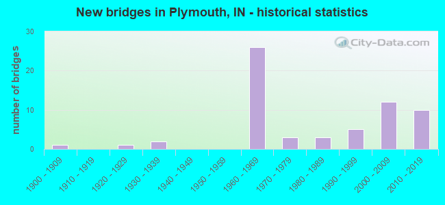
- New bridges - historical statistics
- 11900-1909
- 11920-1929
- 21930-1939
- 261960-1969
- 31970-1979
- 31980-1989
- 51990-1999
- 122000-2009
- 102010-2019
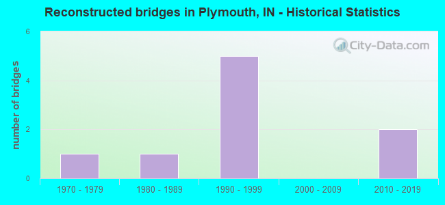
- Reconstructed bridges - Historical Statistics
- 11970-1979
- 11980-1989
- 51990-1999
- 02000-2009
- 22010-2019
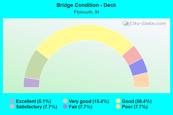
- Bridge Condition - Deck
- 5.1%Excellent
- 15.4%Very good
- 56.4%Good
- 7.7%Satisfactory
- 7.7%Fair
- 7.7%Poor
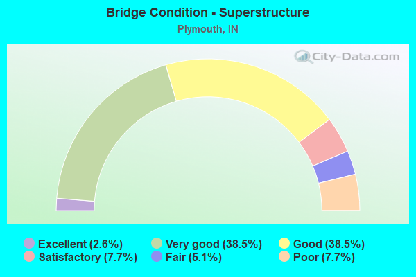
- Bridge Condition - Superstructure
- 2.6%Excellent
- 38.5%Very good
- 38.5%Good
- 7.7%Satisfactory
- 5.1%Fair
- 7.7%Poor
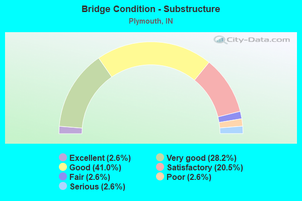
- Bridge Condition - Substructure
- 2.6%Excellent
- 28.2%Very good
- 41.0%Good
- 20.5%Satisfactory
- 2.6%Fair
- 2.6%Poor
- 2.6%Serious
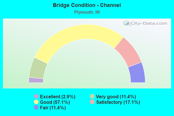
- Bridge Condition - Channel
- 2.9%Excellent
- 11.4%Very good
- 57.1%Good
- 17.1%Satisfactory
- 11.4%Fair
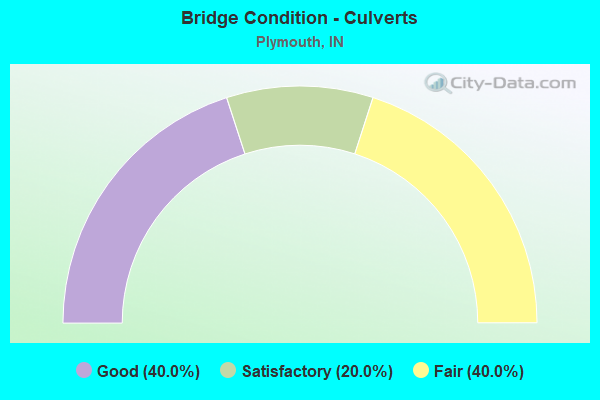
- Bridge Condition - Culverts
- 40.0%Good
- 20.0%Satisfactory
- 40.0%Fair
Find on map >> Show street view
Structure Number: 5000141, Location: 00.25 E OF SR 17 (Lat: 41.330361, Lng: -86.331669), Route carried "on" structure: City street , Year Built: 2000, Status: Open, Structure Length: 4.10m (13.45ft), Average Daily Traffic: 2,725 (year 2020), Truck Traffic: 7%, Average Future Daily Traffic: 4,100 (year 2040), Design Load: HS 20, Features Intersected: WETLAND, Facility Carried by Structure: GLEN OVERMYER DR.
Minimum Vertical Clearance: 30+ m (98+ ft), Kilometerpoint: 0.000, Lanes on structure: 2, Owner: County Highway Agency, Approaching Roadway Width: 12.2m (40.0ft), Material/Design: Concrete continuous, Design/Construction: Slab, Number Of Spans In Main Unit: 5, Length of Maximum Span: 8.8m (28.9ft), Curb-To-Curb Width: 12.2m (40.0ft), Out-to-Out Width: 13.1m (43.0ft)
Condition: Deck: Good, Superstructure: Good, Substructure: Good, Channel: Good, Operating Rating: 32.7 metric tons, Method Used To Determine Operating Rating: Field evaluation and documented engineering judgment, Inventory Rating: 32.7 metric tons, Method Used To Determine Inventory Rating: Field evaluation and documented engineering judgment, Structural Evaluation: Better than present minimum criteria, Deck Geometry: Equal to present minimum criteria, Waterway Adequacy: Better than present minimum criteria, Approach Roadway Alignment: Equal to present desirable criteria, Designated Inspection Frequency: Every 24 months, Inspection Date: October 2020, Deck Structure Type: Concrete Cast-file-Place, Wearing Surface/Protective System: Wearing Surface: Monolithic Concrete, Deck Protection: Epoxy Coated Reinforcing
Find on map >> Show street view
Structure Number: 5000142, Location: 00.40 E OF SR 17 (Lat: 41.330569, Lng: -86.329119), Route carried "on" structure: City street , Year Built: 2000, Status: Open, Structure Length: 7.68m (25.20ft), Average Daily Traffic: 2,725 (year 2020), Truck Traffic: 7%, Average Future Daily Traffic: 3,325 (year 2040), Design Load: HS 20, Features Intersected: YELLOW RIVER, Facility Carried by Structure: GLENN OVERMYER DR.
Minimum Vertical Clearance: 30+ m (98+ ft), Kilometerpoint: 0.000, Lanes on structure: 2, Owner: County Highway Agency, Approaching Roadway Width: 12.2m (40.0ft), Skew: 3 degrees, Material/Design: Prestressed concrete continuous, Design/Construction: Stringer/Multi-beam, Number Of Spans In Main Unit: 3, Length of Maximum Span: 30.5m (100.1ft), Curb-To-Curb Width: 12.3m (40.4ft), Out-to-Out Width: 13.2m (43.3ft)
Condition: Deck: Good, Superstructure: Good, Substructure: Very good, Channel: Good, Operating Rating: 32.7 metric tons, Method Used To Determine Operating Rating: Field evaluation and documented engineering judgment, Inventory Rating: 32.7 metric tons, Method Used To Determine Inventory Rating: Field evaluation and documented engineering judgment, Structural Evaluation: Better than present minimum criteria, Deck Geometry: Equal to present minimum criteria, Waterway Adequacy: Better than present minimum criteria, Approach Roadway Alignment: Equal to present desirable criteria, Designated Inspection Frequency: Every 24 months, Inspection Date: October 2020, Deck Structure Type: Concrete Cast-file-Place, Wearing Surface/Protective System: Wearing Surface: Monolithic Concrete, Deck Protection: Epoxy Coated Reinforcing
Find on map >> Show street view
Structure Number: 5000143, Location: 00.60 E OF SR 17 (Lat: 41.330861, Lng: -86.324839), Route carried "on" structure: City street , Year Built: 2000, Status: Open, Structure Length: 4.11m (13.48ft), Average Daily Traffic: 2,625 (year 2020), Truck Traffic: 7%, Average Future Daily Traffic: 3,125 (year 2040), Design Load: HS 20, Features Intersected: OXBOW WETLANDS, Facility Carried by Structure: GLENN OVERMYER DR.
Minimum Vertical Clearance: 30+ m (98+ ft), Kilometerpoint: 0.000, Lanes on structure: 2, Owner: County Highway Agency, Approaching Roadway Width: 12.2m (40.0ft), Material/Design: Concrete continuous, Design/Construction: Slab, Number Of Spans In Main Unit: 5, Length of Maximum Span: 8.8m (28.9ft), Curb-To-Curb Width: 12.2m (40.0ft), Out-to-Out Width: 13.1m (43.0ft)
Condition: Deck: Good, Superstructure: Good, Substructure: Very good, Channel: Good, Operating Rating: 32.7 metric tons, Method Used To Determine Operating Rating: Field evaluation and documented engineering judgment, Inventory Rating: 32.7 metric tons, Method Used To Determine Inventory Rating: Field evaluation and documented engineering judgment, Structural Evaluation: Better than present minimum criteria, Deck Geometry: Equal to present minimum criteria, Waterway Adequacy: Better than present minimum criteria, Approach Roadway Alignment: Equal to present desirable criteria, Designated Inspection Frequency: Every 24 months, Inspection Date: October 2020, Deck Structure Type: Concrete Cast-file-Place, Wearing Surface/Protective System: Wearing Surface: Monolithic Concrete, Deck Protection: Epoxy Coated Reinforcing
Find on map >> Show street view
Structure Number: 5000146, Location: 00.10 W OF MICHIGAN STREE (Lat: 41.336700, Lng: -86.310211), Route carried "on" structure: City street , Year Built: 2011, Status: Open, Structure Length: 4.48m (14.70ft), Average Daily Traffic: 2,175 (year 2020), Truck Traffic: 2%, Average Future Daily Traffic: 3,250 (year 2040), Design Load: HL 93, Features Intersected: YELLOW RIVER, Facility Carried by Structure: PIERCE STREET
Minimum Vertical Clearance: 30+ m (98+ ft), Kilometerpoint: 0.000, Lanes on structure: 2, Owner: County Highway Agency, Approaching Roadway Width: 7.3m (24.0ft), Skew: 1 degrees, Material/Design: Concrete continuous, Design/Construction: Slab, Number Of Spans In Main Unit: 3, Length of Maximum Span: 16.8m (55.1ft), Curb or Sidewalk Widths: Left: 1.8m (5.9ft), Right: 1.8m (5.9ft), Curb-To-Curb Width: 8.5m (27.9ft), Out-to-Out Width: 12.2m (40.0ft)
Condition: Deck: Good, Superstructure: Good, Substructure: Very good, Channel: Good, Operating Rating: 43.7 metric tons, Method Used To Determine Operating Rating: Load and Resistance Factor (LRFR), Inventory Rating: 36.2 metric tons, Method Used To Determine Inventory Rating: Load and Resistance Factor (LRFR), Structural Evaluation: Better than present minimum criteria, Deck Geometry: Meets minimum limits, Waterway Adequacy: Equal to present desirable criteria, Approach Roadway Alignment: Equal to present minimum criteria, Designated Inspection Frequency: Every 24 months, Inspection Date: October 2020, Deck Structure Type: Concrete Cast-file-Place, Wearing Surface/Protective System: Wearing Surface: Monolithic Concrete, Deck Protection: Epoxy Coated Reinforcing
Find on map >> Show street view
Structure Number: 5000147, Location: 00.40 W OF MUCKSHAW ROAD (Lat: 41.288731, Lng: -86.316939), Route carried "on" structure: County highway 38, Year Built: 2011, Status: Open, Structure Length: 8.55m (28.05ft), Average Daily Traffic: 525 (year 2020), Truck Traffic: 5%, Average Future Daily Traffic: 800 (year 2040), Design Load: HS 20, Features Intersected: YELLOW RIVER, Facility Carried by Structure: WEST 13TH ROAD
Minimum Vertical Clearance: 30+ m (98+ ft), Kilometerpoint: 0.000, Lanes on structure: 2, Owner: County Highway Agency, Approaching Roadway Width: 7.6m (24.9ft), Skew: 5 degrees, Material/Design: Prestressed concrete continuous, Design/Construction: Tee Beam, Number Of Spans In Main Unit: 3, Length of Maximum Span: 27.6m (90.6ft), Curb-To-Curb Width: 7.9m (25.9ft), Out-to-Out Width: 8.1m (26.6ft)
Condition: Deck: Good, Superstructure: Good, Substructure: Good, Channel: Good, Operating Rating: 32.7 metric tons, Method Used To Determine Operating Rating: Field evaluation and documented engineering judgment, Inventory Rating: 32.7 metric tons, Method Used To Determine Inventory Rating: Field evaluation and documented engineering judgment, Structural Evaluation: Better than present minimum criteria, Deck Geometry: High priority of corrective action, Waterway Adequacy: Better than present minimum criteria, Approach Roadway Alignment: Equal to present minimum criteria, Designated Inspection Frequency: Every 24 months, Inspection Date: October 2020, Deck Structure Type: Concrete Cast-file-Place, Wearing Surface/Protective System: Wearing Surface: Monolithic Concrete, Deck Protection: Epoxy Coated Reinforcing
Find on map >> Show street view
Structure Number: 5000148, Location: 00.25 E OF MICHIGAN RD (Lat: 41.373031, Lng: -86.309361), Route carried "on" structure: County highway 759, Year Built: 2015, Status: Open, Structure Length: 2.07m (6.79ft), Average Daily Traffic: 18,350 (year 2020), Truck Traffic: 8%, Average Future Daily Traffic: 22,375 (year 2040), Design Load: HL 93, Features Intersected: ELMER SELTENRIGHT DITCH, Facility Carried by Structure: VETERANS PARKWAY
Minimum Vertical Clearance: 30+ m (98+ ft), Kilometerpoint: 0.000, Lanes on structure: 2, Owner: County Highway Agency, Approaching Roadway Width: 7.3m (24.0ft), Material/Design: Prestressed concrete, Design/Construction: Tee Beam, Number Of Spans In Main Unit: 1, Length of Maximum Span: 20.3m (66.6ft), Curb-To-Curb Width: 14.8m (48.6ft), Out-to-Out Width: 15.4m (50.5ft)
Condition: Deck: Good, Superstructure: Very good, Substructure: Very good, Channel: Very good, Operating Rating: 64.0 metric tons, Method Used To Determine Operating Rating: Load and Resistance Factor (LRFR), Inventory Rating: 50.1 metric tons, Method Used To Determine Inventory Rating: Load and Resistance Factor (LRFR), Structural Evaluation: Equal to present desirable criteria, Deck Geometry: Superior to present desirable criteria, Waterway Adequacy: Superior to present desirable criteria, Approach Roadway Alignment: Equal to present desirable criteria, Designated Inspection Frequency: Every 24 months, Inspection Date: October 2020, Deck Structure Type: Concrete Cast-file-Place, Wearing Surface/Protective System: Wearing Surface: Monolithic Concrete, Deck Protection: Epoxy Coated Reinforcing
Find on map >> Show street view
Structure Number: 451, Location: 01.68 S US 30 (Lat: 41.338600, Lng: -86.310394), Route carried "under" structure: State highway 17, Year Built: 1902, Structure Length: 0. m, Average Daily Traffic: 7,681 (year 2004), Truck Traffic: 10%, Features Intersected: SR 17, Facility Carried by Structure: N&S RR
Minimum Vertical Clearance: 3.35m (10.99ft), Kilometerpoint: 28.485, Lanes under structure: 2, Material/Design: Steel, Design/Construction: Girder and Floorbeam System, Length of Maximum Span: 13.1m (43.0ft)
Find on map >> Show street view
Structure Number: 836, Location: 00.23 W SR-17 (Lat: 41.361800, Lng: -86.316253), Route carried "under" structure: City street , Year Built: 1964, Structure Length: 0. m, Average Daily Traffic: 118 (year 2004), Truck Traffic: 10%, Features Intersected: US 30 EB, Facility Carried by Structure: WESTERN AVENUE
Minimum Vertical Clearance: 6.04m (19.82ft), Kilometerpoint: 0.000, Lanes on structure: 2, Lanes under structure: 2, Material/Design: Steel continuous, Design/Construction: Stringer/Multi-beam, Length of Maximum Span: 13.1m (43.0ft)
Find on map >> Show street view
Structure Number: 837, Location: 00.23 W SR-17 (Lat: 41.362011, Lng: -86.316253), Route carried "under" structure: City street , Year Built: 1964, Structure Length: 0. m, Average Daily Traffic: 118 (year 2004), Truck Traffic: 10%, Features Intersected: US 30 WB, Facility Carried by Structure: WESTERN AVENUE
Minimum Vertical Clearance: 5.87m (19.26ft), Kilometerpoint: 0.000, Lanes on structure: 2, Lanes under structure: 2, Material/Design: Steel continuous, Design/Construction: Stringer/Multi-beam, Length of Maximum Span: 13.1m (43.0ft)
Find on map >> Show street view
Structure Number: 84, Location: 02.19 W of SR-31 (Lat: 41.361981, Lng: -86.311958), Route carried "under" structure: State highway 17, Year Built: 1964, Structure Length: 0. m, Average Daily Traffic: 23,100 (year 2004), Truck Traffic: 10%, Features Intersected: SR-17, Facility Carried by Structure: US 30 EB
Minimum Vertical Clearance: 5.11m (16.77ft), Kilometerpoint: 31.189, Lanes on structure: 3, Lanes under structure: 4, Material/Design: Steel continuous, Design/Construction: Stringer/Multi-beam, Length of Maximum Span: 26.0m (85.3ft)
Find on map >> Show street view
Structure Number: 841, Location: 02.19 W US-31 (Lat: 41.362219, Lng: -86.311989), Route carried "under" structure: State highway 17, Year Built: 1964, Structure Length: 0. m, Average Daily Traffic: 23,100 (year 2004), Truck Traffic: 10%, Features Intersected: SR-17, Facility Carried by Structure: US 30 WB
Minimum Vertical Clearance: 5.39m (17.68ft), Kilometerpoint: 31.205, Lanes on structure: 3, Lanes under structure: 4, Material/Design: Steel continuous, Design/Construction: Stringer/Multi-beam, Length of Maximum Span: 26.0m (85.3ft)
Find on map >> Show street view
Structure Number: 1006, Location: 01.19 S US-30 (Lat: 41.332869, Lng: -86.275903), Route carried "under" structure: County highway , Year Built: 1960, Structure Length: 0. m, Average Daily Traffic: 3,427 (year 2004), Truck Traffic: 6%, Features Intersected: LINCOLN HIGHWAY, Facility Carried by Structure: US 31 NB
Minimum Vertical Clearance: 4.14m (13.58ft), Kilometerpoint: 0.000, Lanes on structure: 2, Lanes under structure: 4, Material/Design: Steel continuous, Design/Construction: Stringer/Multi-beam, Length of Maximum Span: 21.9m (71.9ft)
Find on map >> Show street view
Structure Number: 1006, Location: 01.19 S US-30 (Lat: 41.332869, Lng: -86.275903), Route carried "under" structure: ServiceCounty highway , Year Built: 1960, Structure Length: 0. m, Average Daily Traffic: 500 (year 2010), Truck Traffic: 13%, Features Intersected: 10 TH ROAD, Facility Carried by Structure: US 31 NB
Minimum Vertical Clearance: 4.14m (13.58ft), Kilometerpoint: 0.000, Lanes on structure: 2, Lanes under structure: 4, Material/Design: Steel continuous, Design/Construction: Stringer/Multi-beam, Length of Maximum Span: 21.9m (71.9ft)
Find on map >> Show street view
Structure Number: 1007, Location: 01.19 S US-30 (Lat: 41.332919, Lng: -86.276183), Route carried "under" structure: County highway , Year Built: 1960, Structure Length: 0. m, Average Daily Traffic: 3,423 (year 2011), Truck Traffic: 6%, Features Intersected: LINCOLN HIGHWAY, Facility Carried by Structure: US 31 SB
Minimum Vertical Clearance: 4.22m (13.85ft), Kilometerpoint: 0.000, Lanes on structure: 2, Lanes under structure: 4, Material/Design: Steel continuous, Design/Construction: Stringer/Multi-beam, Length of Maximum Span: 21.9m (71.9ft)
Find on map >> Show street view
Structure Number: 1007, Location: 01.19 S US-30 (Lat: 41.332919, Lng: -86.276183), Route carried "under" structure: County highway , Year Built: 1960, Structure Length: 0. m, Average Daily Traffic: 500 (year 2011), Truck Traffic: 13%, Features Intersected: 10 TH ROAD, Facility Carried by Structure: US 31 SB
Minimum Vertical Clearance: 4.44m (14.57ft), Kilometerpoint: 0.000, Lanes on structure: 2, Lanes under structure: 4, Material/Design: Steel continuous, Design/Construction: Stringer/Multi-beam, Length of Maximum Span: 21.9m (71.9ft)
Find on map >> Show street view
Structure Number: 1008, Location: 07.83 N SR-10 (Lat: 41.349739, Lng: -86.273467), Route carried "under" structure: US 30, Year Built: 1960, Structure Length: 0. m, Average Daily Traffic: 14,507 (year 2004), Truck Traffic: 50%, Features Intersected: US-30 EBL, Facility Carried by Structure: US 31 NB
Minimum Vertical Clearance: 5.16m (16.93ft), Kilometerpoint: 16.592, Lanes on structure: 3, Lanes under structure: 6, Material/Design: Steel continuous, Design/Construction: Stringer/Multi-beam, Length of Maximum Span: 22.3m (73.2ft)
Find on map >> Show street view
Structure Number: 1008, Location: 07.83 N SR-10 (Lat: 41.349739, Lng: -86.273467), Route carried "under" structure: US 30, Year Built: 1960, Structure Length: 0. m, Average Daily Traffic: 7,480 (year 2010), Truck Traffic: 50%, Features Intersected: US-30 WBL, Facility Carried by Structure: US 31 NB
Minimum Vertical Clearance: 5.16m (16.93ft), Kilometerpoint: 16.592, Lanes on structure: 3, Lanes under structure: 6, Material/Design: Steel continuous, Design/Construction: Stringer/Multi-beam, Length of Maximum Span: 22.3m (73.2ft)
Find on map >> Show street view
Structure Number: 1009, Location: 07.83 N SR-10 (Lat: 41.349950, Lng: -86.273689), Route carried "under" structure: US 30, Year Built: 1960, Structure Length: 0. m, Average Daily Traffic: 7,260 (year 2004), Truck Traffic: 20%, Features Intersected: US-30 WBL, Facility Carried by Structure: US 31 SB
Minimum Vertical Clearance: 5.21m (17.09ft), Kilometerpoint: 16.576, Lanes on structure: 3, Lanes under structure: 6, Material/Design: Steel continuous, Design/Construction: Stringer/Multi-beam, Length of Maximum Span: 22.3m (73.2ft)
Find on map >> Show street view
Structure Number: 1009, Location: 07.83 N SR-10 (Lat: 41.349950, Lng: -86.273689), Route carried "under" structure: US 30, Year Built: 1960, Structure Length: 0. m, Average Daily Traffic: 7,260 (year 2004), Truck Traffic: 20%, Features Intersected: US-30 EBL, Facility Carried by Structure: US 31 SB
Minimum Vertical Clearance: 5.21m (17.09ft), Kilometerpoint: 16.576, Lanes on structure: 3, Lanes under structure: 6, Material/Design: Steel continuous, Design/Construction: Stringer/Multi-beam, Length of Maximum Span: 22.3m (73.2ft)
Find on map >> Show street view
Structure Number: 76558, Location: 01.32 N US 30 (Lat: 41.367089, Lng: -86.277869), Route carried "under" structure: US 31, Year Built: 2009, Structure Length: 0. m, Average Daily Traffic: 7,500 (year 2010), Truck Traffic: 10%, Features Intersected: US-31 SBL, Facility Carried by Structure: PLYM/GOSHEN TRAIL
Minimum Vertical Clearance: 5.59m (18.34ft), Kilometerpoint: 22.273, Lanes on structure: 2, Lanes under structure: 4, Material/Design: Steel continuous, Design/Construction: Stringer/Multi-beam, Length of Maximum Span: 37.9m (124.3ft)
Find on map >> Show street view
Structure Number: 76558, Location: 01.32 N US 30 (Lat: 41.367089, Lng: -86.277869), Route carried "under" structure: US 31, Year Built: 2009, Structure Length: 0. m, Average Daily Traffic: 7,500 (year 2010), Truck Traffic: 10%, Features Intersected: US-31 NBL, Facility Carried by Structure: PLYM/GOSHEN TRAIL
Minimum Vertical Clearance: 5.61m (18.41ft), Kilometerpoint: 22.273, Lanes on structure: 2, Lanes under structure: 4, Material/Design: Steel continuous, Design/Construction: Stringer/Multi-beam, Length of Maximum Span: 37.9m (124.3ft)
Find on map >> Show street view
Structure Number: 7656, Location: 03.07 N US-30 (Lat: 41.391061, Lng: -86.287758), Route carried "under" structure: US 31, Year Built: 2009, Structure Length: 0. m, Average Daily Traffic: 6,270 (year 2006), Truck Traffic: 34%, Features Intersected: US-31 NBL, Facility Carried by Structure: W 6TH RD
Minimum Vertical Clearance: 5.31m (17.42ft), Kilometerpoint: 25.170, Lanes on structure: 2, Lanes under structure: 4, Material/Design: Prestressed concrete continuous, Design/Construction: Tee Beam, Length of Maximum Span: 32.4m (106.3ft)
Find on map >> Show street view
Structure Number: 7656, Location: 03.07 N US-30 (Lat: 41.391061, Lng: -86.287758), Route carried "under" structure: US 31, Year Built: 2009, Structure Length: 0. m, Average Daily Traffic: 6,270 (year 2006), Truck Traffic: 34%, Features Intersected: US-31 SBL, Facility Carried by Structure: W 6TH RD
Minimum Vertical Clearance: 5.33m (17.49ft), Kilometerpoint: 25.170, Lanes on structure: 2, Lanes under structure: 4, Material/Design: Prestressed concrete continuous, Design/Construction: Tee Beam, Length of Maximum Span: 32.4m (106.3ft)
Find on map >> Show street view
Structure Number: 80612, Location: 01.14 S US 6 (Lat: 41.376669, Lng: -86.282111), Route carried "under" structure: US 31, Year Built: 2015, Structure Length: 0. m, Average Daily Traffic: 15,000 (year 2013), Truck Traffic: 8%, Features Intersected: US 31 NB, Facility Carried by Structure: 7TH ROAD
Minimum Vertical Clearance: 5.46m (17.91ft), Kilometerpoint: 366.013, Lanes on structure: 2, Lanes under structure: 4, Material/Design: Prestressed concrete continuous, Design/Construction: Tee Beam, Length of Maximum Span: 31.7m (104.0ft)
Find on map >> Show street view
Structure Number: 80612, Location: 01.14 S US 6 (Lat: 41.376669, Lng: -86.282111), Route carried "under" structure: US 31, Year Built: 2015, Structure Length: 0. m, Average Daily Traffic: 15,000 (year 2013), Truck Traffic: 8%, Features Intersected: US 31 SB, Facility Carried by Structure: 7TH ROAD
Minimum Vertical Clearance: 5.21m (17.09ft), Kilometerpoint: 366.013, Lanes on structure: 2, Lanes under structure: 4, Material/Design: Prestressed concrete continuous, Design/Construction: Tee Beam, Length of Maximum Span: 31.7m (104.0ft)