Bridge Statistics for Plymouth Meeting, Pennsylvania (PA)
Condition, Traffic, Stress, Structural Evaluation, Project Costs
- National Bridge Inventory (NBI) Statistics
- 87Number of bridges
- 873ft / 266mTotal length
- $22,182,000Total costs
- 2,563,231Total average daily traffic
- 223,299Total average daily truck traffic
- National Bridge Inventory (NBI) Registered Bridges for Plymouth Meeting
- No street view available for this location
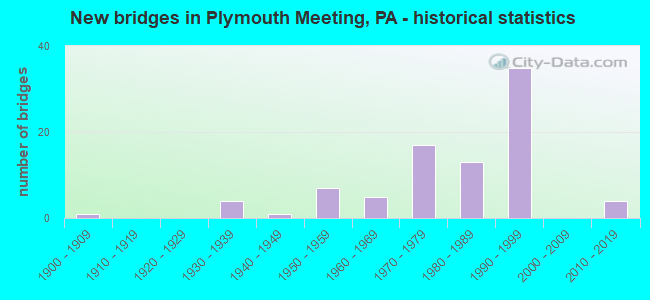
- New bridges - historical statistics
- 11900-1909
- 41930-1939
- 11940-1949
- 71950-1959
- 51960-1969
- 171970-1979
- 131980-1989
- 351990-1999
- 42010-2019
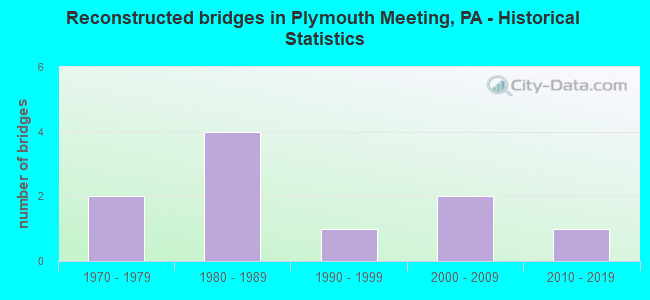
- Reconstructed bridges - Historical Statistics
- 21970-1979
- 41980-1989
- 11990-1999
- 22000-2009
- 12010-2019
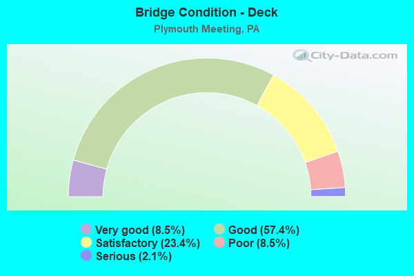
- Bridge Condition - Deck
- 8.5%Very good
- 57.4%Good
- 23.4%Satisfactory
- 8.5%Poor
- 2.1%Serious
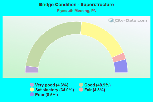
- Bridge Condition - Superstructure
- 4.3%Very good
- 48.9%Good
- 34.0%Satisfactory
- 4.3%Fair
- 8.5%Poor
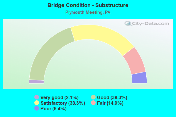
- Bridge Condition - Substructure
- 2.1%Very good
- 38.3%Good
- 38.3%Satisfactory
- 14.9%Fair
- 6.4%Poor
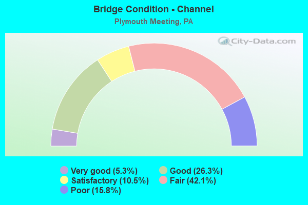
- Bridge Condition - Channel
- 5.3%Very good
- 26.3%Good
- 10.5%Satisfactory
- 42.1%Fair
- 15.8%Poor
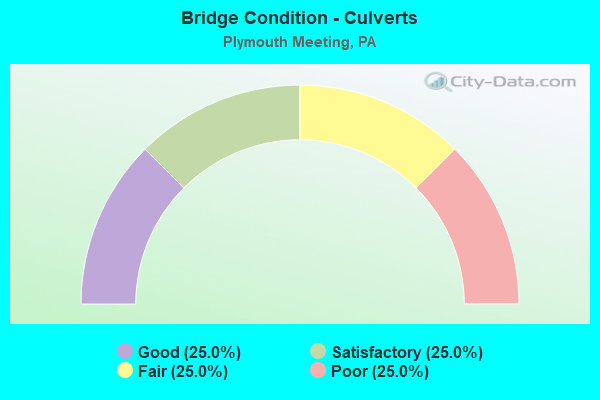
- Bridge Condition - Culverts
- 25.0%Good
- 25.0%Satisfactory
- 25.0%Fair
- 25.0%Poor
Find on map >> Show street view
Structure Number: 28171, Location: MID-COUNTY INTERCHANGE (Lat: 40.112833, Lng: -75.277103), Route carried "on" structure: Ramp Interstate 476, Year Built: 1992, Status: Open, Structure Length: 12.50m (41.01ft), Average Daily Traffic: 57,897 (year 1993), Truck Traffic: 9%, Average Future Daily Traffic: 61,426 (year 2030), Design Load: HS 25 or greater, Features Intersected: PA TPK (I-276), Facility Carried by Structure: PA TPK RAMP N&O
Minimum Vertical Clearance: 30+ m (98+ ft), Kilometerpoint: 0.000, Lanes on structure: 3, Lanes under structure: 16, Base Highway Network: Yes, Toll: On toll road, Owner: State Toll Authority, Approaching Roadway Width: 23.2m (76.1ft), Skew: 9 degrees, Material/Design: Steel continuous, Design/Construction: Stringer/Multi-beam, Number Of Spans In Main Unit: 3, Length of Maximum Span: 67.1m (220.1ft), Curb or Sidewalk Widths: Left: 0.2m (0.7ft), Right: 0.2m (0.7ft), Curb-To-Curb Width: 23.2m (76.1ft), Out-to-Out Width: 23.9m (78.4ft)
Condition: Deck: Good, Superstructure: Good, Substructure: Good, Operating Rating: 72.6 metric tons, Method Used To Determine Operating Rating: Load Factor (LF), Inventory Rating: 43.5 metric tons, Method Used To Determine Inventory Rating: Load Factor (LF), Structural Evaluation: Better than present minimum criteria, Deck Geometry: Superior to present desirable criteria, Underclear: Meets minimum limits, Approach Roadway Alignment: Better than present minimum criteria, Length Of Structure Improvement: 13.30m (43.64ft), Designated Inspection Frequency: Every 24 months, Inspection Date: May 2020, Deck Structure Type: Concrete Cast-file-Place, Wearing Surface/Protective System: Wearing Surface: Latex Concrete, Deck Protection: Epoxy Coated Reinforcing
Find on map >> Show street view
Structure Number: 28172, Location: MID COUNTY INTERCHANGE (Lat: 40.112894, Lng: -75.276781), Route carried "on" structure: Ramp Other road , Year Built: 1992, Status: Open, Structure Length: 14.97m (49.11ft), Average Daily Traffic: 16,340 (year 2008), Truck Traffic: 14%, Average Future Daily Traffic: 25,100 (year 2030), Design Load: HS 25 or greater, Features Intersected: PA TPK (I-276), Facility Carried by Structure: PA TPK (Ramp I)
Minimum Vertical Clearance: 4.71m (15.45ft), Kilometerpoint: 0.000, Lanes on structure: 2, Lanes under structure: 6, Base Highway Network: Yes, Owner: State Toll Authority, Approaching Roadway Width: 14.6m (47.9ft), Skew: 6 degrees, Material/Design: Steel continuous, Design/Construction: Stringer/Multi-beam, Number Of Spans In Main Unit: 4, Length of Maximum Span: 44.2m (145.0ft), Curb-To-Curb Width: 14.6m (47.9ft), Out-to-Out Width: 15.4m (50.5ft)
Condition: Deck: Good, Superstructure: Good, Substructure: Satisfactory, Operating Rating: 78.0 metric tons, Method Used To Determine Operating Rating: Load Factor (LF), Inventory Rating: 46.3 metric tons, Method Used To Determine Inventory Rating: Load Factor (LF), Structural Evaluation: Equal to present minimum criteria, Deck Geometry: High priority of corrective action, Underclear: High priority of corrective action, Approach Roadway Alignment: Better than present minimum criteria, Length Of Structure Improvement: 15.70m (51.51ft), Designated Inspection Frequency: Every 48 months, Inspection Date: August 2018, Deck Structure Type: Concrete Cast-file-Place, Wearing Surface/Protective System: Wearing Surface: Latex Concrete, Deck Protection: Epoxy Coated Reinforcing
Find on map >> Show street view
Structure Number: 28174, Location: EAST OF NORRISTOWN INTG (Lat: 40.113872, Lng: -75.271764), Route carried "on" structure: Interstate 276, Year Built: 1954, Year Reconstructed: 1987, Status: Open, Structure Length: 0.94m (3.08ft), Average Daily Traffic: 73,197 (year 2001), Truck Traffic: 14%, Average Future Daily Traffic: 115,988 (year 2030), Design Load: HS 20, Features Intersected: T-357, Narcissa Road
Minimum Vertical Clearance: 30+ m (98+ ft), Kilometerpoint: 0.000, Lanes on structure: 8, Lanes under structure: 2, Base Highway Network: Yes, Toll: On toll road, Owner: State Toll Authority, Approaching Roadway Width: 39.6m (129.9ft), Skew: 30 degrees, Number Of Spans In Main Unit: 1, Length of Maximum Span: 8.5m (27.9ft), Curb or Sidewalk Widths: Left: 0.2m (0.7ft), Right: 0.2m (0.7ft), Curb-To-Curb Width: 38.5m (126.3ft), Out-to-Out Width: 40.7m (133.5ft)
Condition: Deck: Satisfactory, Superstructure: Satisfactory, Substructure: Satisfactory, Operating Rating: 48.1 metric tons, Method Used To Determine Operating Rating: Load Factor (LF), Inventory Rating: 28.1 metric tons, Method Used To Determine Inventory Rating: Load Factor (LF), Structural Evaluation: Equal to present minimum criteria, Deck Geometry: Superior to present desirable criteria, Underclear: Meets minimum limits, Approach Roadway Alignment: Equal to present desirable criteria, Length Of Structure Improvement: 1.60m (5.25ft), Designated Inspection Frequency: Every 24 months, Inspection Date: May 2021, Bridge Improvement Cost: $15,000, Roadway Improvement Cost: $44,000, Total Project Cost: $201,000, Deck Structure Type: Concrete Cast-file-Place, Wearing Surface/Protective System: Wearing Surface: Latex Concrete
Find on map >> Show street view
Structure Number: 28175, Location: EAST OF NORRISTOWN INTG (Lat: 40.114725, Lng: -75.267100), Route carried "on" structure: Interstate 276, Year Built: 1954, Year Reconstructed: 1987, Status: Open, Structure Length: 2.19m (7.19ft), Average Daily Traffic: 73,197 (year 2001), Truck Traffic: 13%, Average Future Daily Traffic: 100,670 (year 2030), Design Load: HS 20, Features Intersected: T-343, BUTLER PIKE
Minimum Vertical Clearance: 30+ m (98+ ft), Kilometerpoint: 0.000, Lanes on structure: 6, Lanes under structure: 2, Base Highway Network: Yes, Toll: On toll road, Owner: State Toll Authority, Approaching Roadway Width: 32.3m (106.0ft), Skew: 35 degrees, Material/Design: Steel, Design/Construction: Stringer/Multi-beam, Number Of Spans In Main Unit: 1, Length of Maximum Span: 18.9m (62.0ft), Curb or Sidewalk Widths: Left: 0.2m (0.7ft), Right: 0.2m (0.7ft), Curb-To-Curb Width: 31.4m (103.0ft), Out-to-Out Width: 33.4m (109.6ft)
Condition: Deck: Good, Superstructure: Satisfactory, Substructure: Fair, Operating Rating: 88.0 metric tons, Method Used To Determine Operating Rating: Load Factor (LF), Inventory Rating: 52.6 metric tons, Method Used To Determine Inventory Rating: Load Factor (LF), Structural Evaluation: Somewhat better than minimum adequacy, Deck Geometry: Superior to present desirable criteria, Underclear: Meets minimum limits, Approach Roadway Alignment: Equal to present desirable criteria, Length Of Structure Improvement: 2.90m (9.51ft), Designated Inspection Frequency: Every 24 months, Inspection Date: May 2021, Deck Structure Type: Concrete Cast-file-Place, Wearing Surface/Protective System: Wearing Surface: Latex Concrete
Find on map >> Show street view
Structure Number: 28297, Location: SOUTH TPK.EXT.25 29J10 (Lat: 40.108972, Lng: -75.283611), Route carried "on" structure: Ramp State highway , Year Built: 1989, Status: Open, Structure Length: 4.18m (13.71ft), Average Daily Traffic: 7,010 (year 2021), Truck Traffic: 8%, Average Future Daily Traffic: 16,887 (year 2032), Design Load: HS 25 or greater, Features Intersected: GERMANTOWN PIKE/ 3368-E3, Facility Carried by Structure: RAMP D TO(SB)I-476
Minimum Vertical Clearance: 30+ m (98+ ft), Kilometerpoint: 0.000, Lanes on structure: 1, Lanes under structure: 4, Base Highway Network: Yes, Owner: State Highway Agency, Approaching Roadway Width: 12.2m (40.0ft), Skew: 2 degrees, Material/Design: Steel, Design/Construction: Stringer/Multi-beam, Number Of Spans In Main Unit: 1, Length of Maximum Span: 40.2m (131.9ft), Curb or Sidewalk Widths: Left: 0.2m (0.7ft), Right: 0.2m (0.7ft), Curb-To-Curb Width: 10.4m (34.1ft), Out-to-Out Width: 11.1m (36.4ft)
Condition: Deck: Good, Superstructure: Good, Substructure: Good, Operating Rating: 94.3 metric tons, Method Used To Determine Operating Rating: Load Factor (LF), Inventory Rating: 56.2 metric tons, Method Used To Determine Inventory Rating: Load Factor (LF), Structural Evaluation: Better than present minimum criteria, Deck Geometry: Superior to present desirable criteria, Underclear: Equal to present minimum criteria, Approach Roadway Alignment: Equal to present desirable criteria, Length Of Structure Improvement: 5.10m (16.73ft), Designated Inspection Frequency: Every 24 months, Inspection Date: September 2021, Deck Structure Type: Concrete Cast-file-Place, Wearing Surface/Protective System: Wearing Surface: Monolithic Concrete, Deck Protection: Epoxy Coated Reinforcing
Find on map >> Show street view
Structure Number: 33336, Location: 1.7 MI WEST OF WESTFIELD (Lat: 41.915631, Lng: -77.571225), Route carried "on" structure: City street , Year Built: 1989, Status: Open, Structure Length: 2.47m (8.10ft), Average Daily Traffic: 50 (year 2021), Average Future Daily Traffic: 77 (year 2043), Design Load: HS 20, Features Intersected: COWANESQUE RIVER, Facility Carried by Structure: T-336 CTY BR #18
Minimum Vertical Clearance: 30+ m (98+ ft), Kilometerpoint: 0.000, Lanes on structure: 2, Owner: County Highway Agency, Approaching Roadway Width: 7.6m (24.9ft), Material/Design: Prestressed concrete, Design/Construction: Box Beam or Girders - Multiple, Number Of Spans In Main Unit: 1, Length of Maximum Span: 24.4m (80.1ft), Curb or Sidewalk Widths: Left: 0.2m (0.7ft), Right: 0.2m (0.7ft), Curb-To-Curb Width: 7.9m (25.9ft), Out-to-Out Width: 8.7m (28.5ft)
Condition: Deck: Good, Superstructure: Good, Substructure: Good, Channel: Good, Inventory Rating: 49.0 metric tons, Method Used To Determine Inventory Rating: Load Factor (LF), Structural Evaluation: Better than present minimum criteria, Deck Geometry: Equal to present minimum criteria, Waterway Adequacy: Equal to present desirable criteria, Approach Roadway Alignment: Equal to present desirable criteria, Length Of Structure Improvement: 2.50m (8.20ft), Designated Inspection Frequency: Every 24 months, Inspection Date: July 2021, Deck Structure Type: Concrete Cast-file-Place, Wearing Surface/Protective System: Wearing Surface: Monolithic Concrete, Deck Protection: Epoxy Coated Reinforcing
Find on map >> Show street view
Structure Number: 33503, Location: 11 MI W OF WHITE DEER (Lat: 41.041444, Lng: -77.133664), Route carried "on" structure: State highway , Year Built: 1970, Status: Open, Structure Length: 10.42m (34.19ft), Average Daily Traffic: 55 (year 2019), Truck Traffic: 9%, Average Future Daily Traffic: 19 (year 2032), Design Load: HS 20, Features Intersected: OVER I-80, Facility Carried by Structure: SR 80
Minimum Vertical Clearance: 30+ m (98+ ft), Kilometerpoint: 1.025, Lanes on structure: 2, Lanes under structure: 8, Owner: State Highway Agency, Approaching Roadway Width: 6.1m (20.0ft), Skew: 2 degrees, Material/Design: Prestressed concrete, Design/Construction: Box Beam or Girders - Single/Spread, Number Of Spans In Main Unit: 6, Length of Maximum Span: 22.3m (73.2ft), Curb or Sidewalk Widths: Left: 0.2m (0.7ft), Right: 0.2m (0.7ft), Curb-To-Curb Width: 9.0m (29.5ft), Out-to-Out Width: 10.2m (33.5ft)
Condition: Deck: Satisfactory, Superstructure: Satisfactory, Substructure: Satisfactory, Operating Rating: 63.5 metric tons, Method Used To Determine Operating Rating: Load Factor (LF), Inventory Rating: 38.1 metric tons, Method Used To Determine Inventory Rating: Load Factor (LF), Structural Evaluation: Equal to present minimum criteria, Deck Geometry: Better than present minimum criteria, Underclear: Equal to present minimum criteria, Approach Roadway Alignment: Equal to present desirable criteria, Length Of Structure Improvement: 11.40m (37.40ft), Designated Inspection Frequency: Every 24 months, Inspection Date: May 2020, Bridge Improvement Cost: $7,000, Roadway Improvement Cost: $57,000, Total Project Cost: $204,000, Deck Structure Type: Concrete Cast-file-Place, Wearing Surface/Protective System: Wearing Surface: Epoxy Overlay, Deck Protection: Epoxy Coated Reinforcing
Find on map >> Show street view
Structure Number: 33629, Location: 0.5 MI SW RUNNING GAP RD (Lat: 41.024097, Lng: -77.064800), Route carried "on" structure: State lands road , Year Built: 1935, Year Reconstructed: 1976, Status: Open, Structure Length: 0.91m (2.99ft), Average Daily Traffic: 15 (year 2012), Average Future Daily Traffic: 20 (year 2032), Design Load: H 20, Features Intersected: SPRUCE RUN, Facility Carried by Structure: SPRUCE RUN ROAD
Minimum Vertical Clearance: 30+ m (98+ ft), Kilometerpoint: 0.000, Lanes on structure: 1, Owner: State Park, Forest, or Reservation Agency, Approaching Roadway Width: 4.6m (15.1ft), Skew: 2 degrees, Material/Design: Steel, Design/Construction: Stringer/Multi-beam, Number Of Spans In Main Unit: 1, Length of Maximum Span: 8.2m (26.9ft), Curb-To-Curb Width: 4.7m (15.4ft), Out-to-Out Width: 4.9m (16.1ft)
Condition: Deck: Satisfactory, Superstructure: Satisfactory, Substructure: Satisfactory, Channel: Fair, Operating Rating: 52.6 metric tons, Method Used To Determine Operating Rating: Load Factor (LF), Inventory Rating: 31.8 metric tons, Method Used To Determine Inventory Rating: Load Factor (LF), Structural Evaluation: Equal to present minimum criteria, Deck Geometry: Better than present minimum criteria, Waterway Adequacy: Better than present minimum criteria, Approach Roadway Alignment: Equal to present desirable criteria, Length Of Structure Improvement: 0.90m (2.95ft), Designated Inspection Frequency: Every 24 months, Inspection Date: October 2020, Bridge Improvement Cost: $25,000, Total Project Cost: $60,000, Deck Structure Type: Closed Grating, Wearing Surface/Protective System: Wearing Surface: Monolithic Concrete
Find on map >> Show street view
Structure Number: 35106, Location: ROBINSON TOWNSHIP (Lat: 40.421111, Lng: -80.337694), Route carried "on" structure: State highway , Year Built: 1968, Status: Open, Structure Length: 0.88m (2.89ft), Average Daily Traffic: 839 (year 2020), Truck Traffic: 6%, Average Future Daily Traffic: 879 (year 2032), Design Load: HS 20+Mod, Features Intersected: SAINT PATRICK RUN, Facility Carried by Structure: SR 4004
Minimum Vertical Clearance: 30+ m (98+ ft), Kilometerpoint: 17.337, Lanes on structure: 2, Owner: State Highway Agency, Approaching Roadway Width: 7.9m (25.9ft), Skew: 2 degrees, Material/Design: Concrete, Design/Construction: Culvert, Number Of Spans In Main Unit: 1, Length of Maximum Span: 8.8m (28.9ft)
Condition: Channel: Poor, Culverts: Fair, Inventory Rating: 99.8 metric tons, Method Used To Determine Inventory Rating: Field evaluation and documented engineering judgment, Structural Evaluation: Somewhat better than minimum adequacy, Waterway Adequacy: Superior to present desirable criteria, Approach Roadway Alignment: Equal to present desirable criteria, Length Of Structure Improvement: 1.60m (5.25ft), Designated Inspection Frequency: Every 24 months, Inspection Date: October 2021
Find on map >> Show street view
Structure Number: 46454, Location: .5 MI. N. I-276 3256E10 (Lat: 40.126306, Lng: -75.284092), Route carried "on" structure: State highway , Year Built: 2011, Status: Open, Structure Length: 6.64m (21.78ft), Average Daily Traffic: 15,022 (year 2022), Truck Traffic: 5%, Average Future Daily Traffic: 21,114 (year 2032), Design Load: HL 93, Features Intersected: PA TPK NE EXT. (I-476), Facility Carried by Structure: WALTON ROAD
Minimum Vertical Clearance: 30+ m (98+ ft), Kilometerpoint: 2.448, Lanes on structure: 3, Lanes under structure: 6, Owner: State Highway Agency, Approaching Roadway Width: 18.0m (59.1ft), Skew: 3 degrees, Material/Design: Prestressed concrete continuous, Design/Construction: Stringer/Multi-beam, Number Of Spans In Main Unit: 2, Length of Maximum Span: 32.6m (107.0ft), Curb or Sidewalk Widths: Left: 0.1m (0.3ft), Right: 0.1m (0.3ft), Curb-To-Curb Width: 17.7m (58.1ft), Out-to-Out Width: 18.7m (61.4ft)
Condition: Deck: Good, Superstructure: Good, Substructure: Good, Operating Rating: 63.2 metric tons, Method Used To Determine Operating Rating: Assigned ratings based on Load and Resistance Factor Design (LRFD) reported by rating factor (RF) using HL93 loadings, Inventory Rating: 36.0 metric tons, Method Used To Determine Inventory Rating: Assigned ratings based on Load and Resistance Factor Design (LRFD) reported by rating factor (RF) using HL93 loadings, Structural Evaluation: Better than present minimum criteria, Deck Geometry: Superior to present desirable criteria, Underclear: Somewhat better than minimum adequacy, Approach Roadway Alignment: Equal to present desirable criteria, Designated Inspection Frequency: Every 24 months, Inspection Date: March 2021, Deck Structure Type: Concrete Cast-file-Place, Wearing Surface/Protective System: Wearing Surface: Monolithic Concrete, Membrane: Other, Deck Protection: Epoxy Coated Reinforcing
Find on map >> Show street view
Structure Number: 48848, Location: Near Mid-County Interchan (Lat: 40.118333, Lng: -75.280000), Route carried "on" structure: Interstate 476, Year Built: 2014, Status: Open, Structure Length: 1.55m (5.09ft), Average Daily Traffic: 65,329 (year 2004), Truck Traffic: 16%, Average Future Daily Traffic: 94,986 (year 2030), Design Load: HL 93, Features Intersected: T-645
Minimum Vertical Clearance: 30+ m (98+ ft), Kilometerpoint: 32.879, Lanes on structure: 6, Lanes under structure: 2, Base Highway Network: Yes, Toll: On toll road, Owner: State Toll Authority, Approaching Roadway Width: 35.7m (117.1ft), Skew: 31 degrees, Material/Design: Prestressed concrete, Design/Construction: Box Beam or Girders - Single/Spread, Number Of Spans In Main Unit: 1, Length of Maximum Span: 14.6m (47.9ft), Curb or Sidewalk Widths: Left: 2.5m (8.2ft), Right: 2.5m (8.2ft), Curb-To-Curb Width: 34.7m (113.8ft), Out-to-Out Width: 37.6m (123.4ft)
Condition: Deck: Very good, Superstructure: Very good, Substructure: Good, Operating Rating: 49.9 metric tons, Method Used To Determine Operating Rating: Assigned ratings based on Load and Resistance Factor Design (LRFD) reported by rating factor (RF) using HL93 loadings, Inventory Rating: 38.6 metric tons, Method Used To Determine Inventory Rating: Assigned ratings based on Load and Resistance Factor Design (LRFD) reported by rating factor (RF) using HL93 loadings, Structural Evaluation: Better than present minimum criteria, Deck Geometry: Superior to present desirable criteria, Underclear: Equal to present minimum criteria, Approach Roadway Alignment: Equal to present desirable criteria, Designated Inspection Frequency: Every 24 months, Inspection Date: June 2020, Deck Structure Type: Concrete Cast-file-Place, Wearing Surface/Protective System: Wearing Surface: Monolithic Concrete, Deck Protection: Epoxy Coated Reinforcing
Find on map >> Show street view
Structure Number: 52388, Location: 1/8 MI. E. I-476 3368F03 (Lat: 40.110250, Lng: -75.278283), Route carried "on" structure: State highway , Year Built: 2015, Status: Open, Structure Length: 0.98m (3.22ft), Average Daily Traffic: 9,654 (year 2022), Truck Traffic: 6%, Average Future Daily Traffic: 19,599 (year 2032), Design Load: HL 93, Features Intersected: PLYMOUTH CREEK, Facility Carried by Structure: PLYMOUTH ROAD
Minimum Vertical Clearance: 30+ m (98+ ft), Kilometerpoint: 3.727, Lanes on structure: 2, Owner: State Highway Agency, Approaching Roadway Width: 12.2m (40.0ft), Material/Design: Prestressed concrete, Design/Construction: Box Beam or Girders - Multiple, Number Of Spans In Main Unit: 1, Length of Maximum Span: 9.1m (29.9ft), Curb or Sidewalk Widths: Left: 0.2m (0.7ft), Right: 0.2m (0.7ft), Curb-To-Curb Width: 12.2m (40.0ft), Out-to-Out Width: 13.2m (43.3ft)
Condition: Deck: Very good, Superstructure: Very good, Substructure: Very good, Channel: Very good, Operating Rating: 53.1 metric tons, Method Used To Determine Operating Rating: Assigned ratings based on Load and Resistance Factor Design (LRFD) reported by rating factor (RF) using HL93 loadings, Inventory Rating: 41.1 metric tons, Method Used To Determine Inventory Rating: Assigned ratings based on Load and Resistance Factor Design (LRFD) reported by rating factor (RF) using HL93 loadings, Structural Evaluation: Equal to present desirable criteria, Deck Geometry: Somewhat better than minimum adequacy, Waterway Adequacy: Equal to present desirable criteria, Approach Roadway Alignment: Equal to present desirable criteria, Designated Inspection Frequency: Every 24 months, Inspection Date: August 2021, Deck Structure Type: Concrete Cast-file-Place, Wearing Surface/Protective System: Wearing Surface: Monolithic Concrete, Deck Protection: Epoxy Coated Reinforcing
Find on map >> Show street view
Structure Number: 55684, Location: West of Joshua Rd (Lat: 40.089617, Lng: -75.269044), Route carried "on" structure: County highway , Year Built: 1996, Status: Open, Structure Length: 0.67m (2.20ft), Average Daily Traffic: 26,509 (year 2019), Truck Traffic: 2%, Average Future Daily Traffic: 38,923 (year 2018), Features Intersected: SPRING MILL CREEK, Facility Carried by Structure: RIDGE PIKE
Minimum Vertical Clearance: 30+ m (98+ ft), Kilometerpoint: 0.000, Lanes on structure: 4, Base Highway Network: Yes, Owner: County Highway Agency, Approaching Roadway Width: 18.6m (61.0ft), Material/Design: Concrete, Design/Construction: Culvert, Number Of Spans In Main Unit: 1, Length of Maximum Span: 6.7m (22.0ft), Curb-To-Curb Width: 18.6m (61.0ft), Out-to-Out Width: 19.5m (64.0ft)
Condition: Channel: Good, Culverts: Good, Operating Rating: 84.4 metric tons, Method Used To Determine Operating Rating: Field evaluation and documented engineering judgment, Inventory Rating: 50.8 metric tons, Method Used To Determine Inventory Rating: Field evaluation and documented engineering judgment, Structural Evaluation: Better than present minimum criteria, Deck Geometry: Equal to present minimum criteria, Waterway Adequacy: Better than present minimum criteria, Approach Roadway Alignment: Equal to present desirable criteria, Designated Inspection Frequency: Every 24 months, Inspection Date: May 2020
Find on map >> Show street view
Structure Number: 57515, Location: 200FT N HICKORY RD (Lat: 40.120778, Lng: -75.271028), Route carried "on" structure: City street , Year Built: 1960, Status: Open, Structure Length: 0.85m (2.79ft), Average Daily Traffic: 1,000 (year 2020), Truck Traffic: 5%, Average Future Daily Traffic: 1,250 (year 2022), Design Load: H 20, Features Intersected: TRIB TO PLYMOUTH CREEK, Facility Carried by Structure: NARCISSA ROAD
Minimum Vertical Clearance: 30+ m (98+ ft), Kilometerpoint: 0.000, Lanes on structure: 2, Owner: Town or Township Highway Agency, Approaching Roadway Width: 10.4m (34.1ft), Skew: 3 degrees, Material/Design: Concrete, Design/Construction: Culvert, Number Of Spans In Main Unit: 2, Length of Maximum Span: 4.3m (14.1ft), Curb or Sidewalk Widths: Left: 2.7m (8.9ft), Right: 0.0m, Curb-To-Curb Width: 10.4m (34.1ft), Out-to-Out Width: 17.6m (57.7ft)
Condition: Channel: Fair, Culverts: Poor, Operating Rating: 40.8 metric tons, Method Used To Determine Operating Rating: Field evaluation and documented engineering judgment, Inventory Rating: 24.5 metric tons, Method Used To Determine Inventory Rating: Field evaluation and documented engineering judgment, Structural Evaluation: Meets minimum limits, Deck Geometry: Equal to present minimum criteria, Waterway Adequacy: Equal to present desirable criteria, Approach Roadway Alignment: Equal to present desirable criteria, Designated Inspection Frequency: Every 24 months, Inspection Date: April 2020
Find on map >> Show street view
Structure Number: 27482, Location: PLYMOUTH TOWNSHIP 29F12 (Lat: 40.098333, Lng: -75.300000), Route carried "under" structure: Ramp State highway , Year Built: 1978, Structure Length: 0. m, Average Daily Traffic: 3,729 (year 2021), Truck Traffic: 7%, Features Intersected: MID-COUNTY EXPRESSWAY, Facility Carried by Structure: RIDGE PIKE
Minimum Vertical Clearance: 5.07m (16.63ft), Kilometerpoint: 0.000, Lanes on structure: 3, Lanes under structure: 1, Material/Design: Steel continuous, Design/Construction: Stringer/Multi-beam, Length of Maximum Span: 39.0m (128.0ft)
Find on map >> Show street view
Structure Number: 27482, Location: PLYMOUTH TOWNSHIP 29F12 (Lat: 40.098333, Lng: -75.300000), Route carried "under" structure: Interstate 476, Year Built: 1978, Structure Length: 0. m, Average Daily Traffic: 62,382 (year 2022), Truck Traffic: 8%, Features Intersected: MID-COUNTY EXPRESSWAY, Facility Carried by Structure: RIDGE PIKE
Minimum Vertical Clearance: 5.77m (18.93ft), Kilometerpoint: 7.005, Lanes on structure: 3, Lanes under structure: 4, Material/Design: Steel continuous, Design/Construction: Stringer/Multi-beam, Length of Maximum Span: 39.0m (128.0ft)
Find on map >> Show street view
Structure Number: 27482, Location: PLYMOUTH TOWNSHIP 29F12 (Lat: 40.098333, Lng: -75.300000), Route carried "under" structure: Interstate 476, Year Built: 1978, Structure Length: 0. m, Average Daily Traffic: 60,860 (year 2022), Truck Traffic: 10%, Features Intersected: MID-COUNTY EXPRESSWAY, Facility Carried by Structure: RIDGE PIKE
Minimum Vertical Clearance: 5.79m (19.00ft), Kilometerpoint: 6.983, Lanes on structure: 3, Lanes under structure: 3, Material/Design: Steel continuous, Design/Construction: Stringer/Multi-beam, Length of Maximum Span: 39.0m (128.0ft)
Find on map >> Show street view
Structure Number: 27483, Location: PLYMOUTH TOWNSHIP 29G11 (Lat: 40.099219, Lng: -75.294864), Route carried "under" structure: State highway , Year Built: 1974, Structure Length: 0. m, Average Daily Traffic: 7,686 (year 2022), Truck Traffic: 10%, Features Intersected: CHEMICAL ROAD / 3368-C5, Facility Carried by Structure: MID-COUNTY EXWY.NB
Minimum Vertical Clearance: 5.18m (16.99ft), Kilometerpoint: 2.340, Lanes on structure: 3, Lanes under structure: 2, Material/Design: Steel, Design/Construction: Stringer/Multi-beam, Length of Maximum Span: 33.8m (110.9ft)
Find on map >> Show street view
Structure Number: 27483, Location: PLYMOUTH TOWNSHIP 29G11 (Lat: 40.099219, Lng: -75.294864), Route carried "under" structure: State highway , Year Built: 1974, Structure Length: 0. m, Average Daily Traffic: 6,334 (year 2022), Truck Traffic: 8%, Features Intersected: CHEMICAL ROAD / 3368-C5, Facility Carried by Structure: MID-COUNTY EXWY.NB
Minimum Vertical Clearance: 4.69m (15.39ft), Kilometerpoint: 2.340, Lanes on structure: 3, Lanes under structure: 2, Material/Design: Steel, Design/Construction: Stringer/Multi-beam, Length of Maximum Span: 33.8m (110.9ft)
Find on map >> Show street view
Structure Number: 27484, Location: PLYMOUTH TOWNSHIP 29G11 (Lat: 40.099519, Lng: -75.294650), Route carried "under" structure: State highway , Year Built: 1974, Structure Length: 0. m, Average Daily Traffic: 6,334 (year 2022), Truck Traffic: 8%, Features Intersected: CHEMICAL ROAD / 3368-C5, Facility Carried by Structure: MID-COUNTY EXWY.SB
Minimum Vertical Clearance: 4.72m (15.49ft), Kilometerpoint: 2.340, Lanes on structure: 4, Lanes under structure: 2, Material/Design: Steel, Design/Construction: Stringer/Multi-beam, Length of Maximum Span: 35.7m (117.1ft)
Find on map >> Show street view
Structure Number: 27484, Location: PLYMOUTH TOWNSHIP 29G11 (Lat: 40.099519, Lng: -75.294650), Route carried "under" structure: State highway , Year Built: 1974, Structure Length: 0. m, Average Daily Traffic: 7,686 (year 2022), Truck Traffic: 10%, Features Intersected: CHEMICAL ROAD / 3368-C5, Facility Carried by Structure: MID-COUNTY EXWY.SB
Minimum Vertical Clearance: 4.85m (15.91ft), Kilometerpoint: 2.340, Lanes on structure: 4, Lanes under structure: 2, Material/Design: Steel, Design/Construction: Stringer/Multi-beam, Length of Maximum Span: 35.7m (117.1ft)
Find on map >> Show street view
Structure Number: 27487, Location: SW.OF TPK.EXIT 25 29H10 (Lat: 40.103944, Lng: -75.289828), Route carried "under" structure: State highway , Year Built: 1990, Structure Length: 0. m, Average Daily Traffic: 13,265 (year 2022), Truck Traffic: 8%, Features Intersected: CHEMICAL ROAD/3368-D4, Facility Carried by Structure: MID-COUNTY EXWY.NB
Minimum Vertical Clearance: 8.92m (29.27ft), Kilometerpoint: 3.277, Lanes on structure: 3, Lanes under structure: 2, Material/Design: Steel, Design/Construction: Stringer/Multi-beam, Length of Maximum Span: 46.0m (150.9ft)
Find on map >> Show street view
Structure Number: 27487, Location: SW.OF TPK.EXIT 25 29H10 (Lat: 40.103944, Lng: -75.289828), Route carried "under" structure: State highway , Year Built: 1990, Structure Length: 0. m, Average Daily Traffic: 13,355 (year 2022), Truck Traffic: 7%, Features Intersected: CHEMICAL ROAD/3368-D4, Facility Carried by Structure: MID-COUNTY EXWY.NB
Minimum Vertical Clearance: 8.86m (29.07ft), Kilometerpoint: 3.285, Lanes on structure: 3, Lanes under structure: 2, Material/Design: Steel, Design/Construction: Stringer/Multi-beam, Length of Maximum Span: 46.0m (150.9ft)
Find on map >> Show street view
Structure Number: 27489, Location: SW.OF TPK.EXIT 25 29H10 (Lat: 40.103683, Lng: -75.290139), Route carried "under" structure: State highway , Year Built: 1990, Structure Length: 0. m, Average Daily Traffic: 13,265 (year 2022), Truck Traffic: 8%, Features Intersected: CHEMICAL ROAD / 3368-D4, Facility Carried by Structure: MID-COUNTY EXWY.SB
Minimum Vertical Clearance: 7.87m (25.82ft), Kilometerpoint: 3.277, Lanes on structure: 3, Lanes under structure: 2, Material/Design: Steel, Design/Construction: Stringer/Multi-beam, Length of Maximum Span: 52.1m (170.9ft)
Find on map >> Show street view
Structure Number: 27489, Location: SW.OF TPK.EXIT 25 29H10 (Lat: 40.103683, Lng: -75.290139), Route carried "under" structure: State highway , Year Built: 1990, Structure Length: 0. m, Average Daily Traffic: 13,355 (year 2022), Truck Traffic: 7%, Features Intersected: CHEMICAL ROAD / 3368-D4, Facility Carried by Structure: MID-COUNTY EXWY.SB
Minimum Vertical Clearance: 7.92m (25.98ft), Kilometerpoint: 3.285, Lanes on structure: 3, Lanes under structure: 2, Material/Design: Steel, Design/Construction: Stringer/Multi-beam, Length of Maximum Span: 52.1m (170.9ft)
Find on map >> Show street view
Structure Number: 27497, Location: AT TURNPIKE EXT 25 29H09 (Lat: 40.111667, Lng: -75.285000), Route carried "under" structure: ServiceOther road , Year Built: 1989, Structure Length: 0. m, Average Daily Traffic: 200 (year 1991), Truck Traffic: 1%, Features Intersected: ACCESS ROAD / 3368-D3, Facility Carried by Structure: RAMP K
Minimum Vertical Clearance: 5.24m (17.19ft), Kilometerpoint: 0.000, Lanes on structure: 1, Lanes under structure: 2, Material/Design: Prestressed concrete, Design/Construction: Box Beam or Girders - Single/Spread, Length of Maximum Span: 13.1m (43.0ft)
Find on map >> Show street view
Structure Number: 277, Location: JUST E.GERMAN PK. 29J09 (Lat: 40.111722, Lng: -75.283300), Route carried "under" structure: Interstate 276, Year Built: 1989, Structure Length: 0. m, Average Daily Traffic: 7 (year 2005), Features Intersected: PA TURNPK (EB/WB)/3368E3, Facility Carried by Structure: PLYMOUTH ROAD
Minimum Vertical Clearance: 4.57m (14.99ft), Kilometerpoint: 0.000, Lanes on structure: 2, Lanes under structure: 7, Material/Design: Steel, Design/Construction: Stringer/Multi-beam, Length of Maximum Span: 40.8m (133.9ft)
Find on map >> Show street view
Structure Number: 2777, Location: 1MI.NW OF BUTLER 29F11 (Lat: 40.098769, Lng: -75.301006), Route carried "under" structure: ServiceOther road , Year Built: 1977, Structure Length: 0. m, Average Daily Traffic: 500 (year 2005), Truck Traffic: 7%, Features Intersected: ACCESS RD;PLYMOUTH CREEK, Facility Carried by Structure: RIDGE PIKE/3368-B5
Minimum Vertical Clearance: 6.35m (20.83ft), Kilometerpoint: 0.000, Lanes on structure: 5, Lanes under structure: 2, Material/Design: Steel continuous, Design/Construction: Stringer/Multi-beam, Length of Maximum Span: 26.2m (86.0ft)
Find on map >> Show street view
Structure Number: 28162, Location: MID-CTY.INTERCH. 29H09 (Lat: 40.111336, Lng: -75.285397), Route carried "under" structure: Ramp State highway , Year Built: 1991, Structure Length: 0. m, Average Daily Traffic: 8,064 (year 2021), Truck Traffic: 7%, Features Intersected: SR 3053 (RAMP K), Facility Carried by Structure: PA TPK (RAMP R)
Minimum Vertical Clearance: 5.11m (16.77ft), Kilometerpoint: 0.000, Lanes on structure: 1, Lanes under structure: 1, Material/Design: Prestressed concrete, Design/Construction: Box Beam or Girders - Multiple, Length of Maximum Span: 19.8m (65.0ft)
Find on map >> Show street view
Structure Number: 28163, Location: MID-CTY.INTERCH. 29H09 (Lat: 40.111403, Lng: -75.285022), Route carried "under" structure: Ramp State highway , Year Built: 1991, Structure Length: 0. m, Average Daily Traffic: 8,064 (year 2021), Truck Traffic: 7%, Features Intersected: RAMP K, Facility Carried by Structure: PA TPK (RAMP G)
Minimum Vertical Clearance: 5.39m (17.68ft), Kilometerpoint: 0.000, Lanes on structure: 2, Lanes under structure: 1, Material/Design: Prestressed concrete, Design/Construction: Box Beam or Girders - Multiple, Length of Maximum Span: 21.3m (69.9ft)
Find on map >> Show street view
Structure Number: 28164, Location: SR 3053,GERMANTOWN PIKE (Lat: 40.111442, Lng: -75.284797), Route carried "under" structure: Interstate 276, Year Built: 1954, Structure Length: 0. m, Average Daily Traffic: 73,197 (year 2001), Truck Traffic: 13%, Features Intersected: PA TPK (I-276), Facility Carried by Structure: SR 3053,GERMANT.PK
Minimum Vertical Clearance: 4.65m (15.26ft), Kilometerpoint: 0.000, Lanes on structure: 9, Lanes under structure: 6, Material/Design: Steel, Design/Construction: Girder and Floorbeam System, Length of Maximum Span: 29.3m (96.1ft)
Find on map >> Show street view
Structure Number: 28165, Location: PART OF MID-COUNTY INTG (Lat: 40.106667, Lng: -75.285000), Route carried "under" structure: State highway , Year Built: 1991, Structure Length: 0. m, Average Daily Traffic: 21,788 (year 2022), Truck Traffic: 2%, Features Intersected: SR 3053, Facility Carried by Structure: PA TPK (RAMP G)
Minimum Vertical Clearance: 4.32m (14.17ft), Kilometerpoint: 5.317, Lanes on structure: 2, Lanes under structure: 5, Material/Design: Steel continuous, Design/Construction: Stringer/Multi-beam, Length of Maximum Span: 25.0m (82.0ft)
Find on map >> Show street view
Structure Number: 28165, Location: PART OF MID-COUNTY INTG (Lat: 40.106667, Lng: -75.285000), Route carried "under" structure: State highway , Year Built: 1991, Structure Length: 0. m, Average Daily Traffic: 18,678 (year 2022), Truck Traffic: 2%, Features Intersected: SR 3053, Facility Carried by Structure: PA TPK (RAMP G)
Minimum Vertical Clearance: 4.35m (14.27ft), Kilometerpoint: 5.317, Lanes on structure: 2, Lanes under structure: 5, Material/Design: Steel continuous, Design/Construction: Stringer/Multi-beam, Length of Maximum Span: 25.0m (82.0ft)
Find on map >> Show street view
Structure Number: 28166, Location: MID-COUNTY INTERCH.29J09 (Lat: 40.108333, Lng: -75.283333), Route carried "under" structure: State highway , Year Built: 1992, Structure Length: 0. m, Average Daily Traffic: 21,788 (year 2022), Truck Traffic: 2%, Features Intersected: SR 3053; (LR145), Facility Carried by Structure: PATPK I476 ,RP M&N
Minimum Vertical Clearance: 4.87m (15.98ft), Kilometerpoint: 5.317, Lanes on structure: 10, Lanes under structure: 8, Material/Design: Steel, Design/Construction: Stringer/Multi-beam, Length of Maximum Span: 53.6m (175.9ft)
Find on map >> Show street view
Structure Number: 28166, Location: MID-COUNTY INTERCH.29J09 (Lat: 40.108333, Lng: -75.283333), Route carried "under" structure: State highway , Year Built: 1992, Structure Length: 0. m, Average Daily Traffic: 14,999 (year 2022), Truck Traffic: 5%, Features Intersected: SR 3053; (LR145), Facility Carried by Structure: PATPK I476 ,RP M&N
Minimum Vertical Clearance: 4.87m (15.98ft), Kilometerpoint: 5.317, Lanes on structure: 10, Lanes under structure: 8, Material/Design: Steel, Design/Construction: Stringer/Multi-beam, Length of Maximum Span: 53.6m (175.9ft)
Find on map >> Show street view
Structure Number: 28166, Location: MID-COUNTY INTERCH.29J09 (Lat: 40.108333, Lng: -75.283333), Route carried "under" structure: ServiceOther road , Year Built: 1992, Structure Length: 0. m, Features Intersected: SR 3053; (LR145), Facility Carried by Structure: PATPK I476 ,RP M&N
Minimum Vertical Clearance: 5.18m (16.99ft), Kilometerpoint: 0.000, Lanes on structure: 10, Lanes under structure: 8, Toll: On toll road, Material/Design: Steel, Design/Construction: Stringer/Multi-beam, Length of Maximum Span: 53.6m (175.9ft)
Find on map >> Show street view
Structure Number: 28167, Location: MID-COUNTY INTERCHANGE (Lat: 40.112342, Lng: -75.279844), Route carried "under" structure: State highway , Year Built: 1992, Structure Length: 0. m, Average Daily Traffic: 9,654 (year 2022), Truck Traffic: 6%, Features Intersected: SR 3007, Facility Carried by Structure: RAMP M,WAS MCB-102
Minimum Vertical Clearance: 4.67m (15.32ft), Kilometerpoint: 3.727, Lanes on structure: 4, Lanes under structure: 3, Material/Design: Steel, Design/Construction: Stringer/Multi-beam, Length of Maximum Span: 31.4m (103.0ft)
Find on map >> Show street view
Structure Number: 28168, Location: MID-COUNTY INTERCHANGE (Lat: 40.112383, Lng: -75.279606), Route carried "under" structure: State highway , Year Built: 1992, Structure Length: 0. m, Average Daily Traffic: 9,654 (year 2022), Truck Traffic: 6%, Features Intersected: SR 3007, Facility Carried by Structure: RAMP N,WAS MCB-104
Minimum Vertical Clearance: 10.47m (34.35ft), Kilometerpoint: 3.727, Lanes on structure: 2, Lanes under structure: 3, Material/Design: Steel continuous, Design/Construction: Stringer/Multi-beam, Length of Maximum Span: 32.6m (107.0ft)
Find on map >> Show street view
Structure Number: 28169, Location: MID-COUNTY INTERCHANGE (Lat: 40.112472, Lng: -75.279108), Route carried "under" structure: State highway , Year Built: 1993, Structure Length: 0. m, Average Daily Traffic: 9,654 (year 2022), Truck Traffic: 6%, Features Intersected: SR 3007, Facility Carried by Structure: PA TPK (Ramp H)
Minimum Vertical Clearance: 11.38m (37.34ft), Kilometerpoint: 3.727, Lanes on structure: 2, Lanes under structure: 3, Material/Design: Steel continuous, Design/Construction: Stringer/Multi-beam, Length of Maximum Span: 46.9m (153.9ft)
Find on map >> Show street view
Structure Number: 2817, Location: MID-COUNTY INTERCHANGE (Lat: 40.112692, Lng: -75.277878), Route carried "under" structure: Interstate 276, Year Built: 1992, Structure Length: 0. m, Average Daily Traffic: 73,197 (year 2001), Truck Traffic: 13%, Features Intersected: PA TPK(I-276), Facility Carried by Structure: RP M(I-476)MCB-105
Minimum Vertical Clearance: 6.15m (20.18ft), Kilometerpoint: 0.000, Lanes on structure: 3, Lanes under structure: 6, Toll: On toll road, Material/Design: Steel continuous, Design/Construction: Stringer/Multi-beam, Length of Maximum Span: 27.1m (88.9ft)
Find on map >> Show street view
Structure Number: 28171, Location: MID-COUNTY INTERCHANGE (Lat: 40.112833, Lng: -75.277103), Route carried "under" structure: Interstate 476, Year Built: 1992, Structure Length: 0. m, Average Daily Traffic: 58,078 (year 1993), Truck Traffic: 9%, Features Intersected: PA TPK (I-276), Facility Carried by Structure: PA TPK RAMP N&O
Minimum Vertical Clearance: 4.72m (15.49ft), Kilometerpoint: 0.000, Lanes on structure: 3, Lanes under structure: 8, Toll: On toll road, Material/Design: Steel continuous, Design/Construction: Stringer/Multi-beam, Length of Maximum Span: 67.1m (220.1ft)
Find on map >> Show street view
Structure Number: 28171, Location: MID-COUNTY INTERCHANGE (Lat: 40.112833, Lng: -75.277103), Route carried "under" structure: Interstate 276, Year Built: 1992, Structure Length: 0. m, Average Daily Traffic: 73,197 (year 2001), Truck Traffic: 13%, Features Intersected: PA TPK (I-276), Facility Carried by Structure: PA TPK RAMP N&O
Minimum Vertical Clearance: 6.43m (21.10ft), Kilometerpoint: 0.000, Lanes on structure: 3, Lanes under structure: 8, Toll: On toll road, Material/Design: Steel continuous, Design/Construction: Stringer/Multi-beam, Length of Maximum Span: 67.1m (220.1ft)
Find on map >> Show street view
Structure Number: 28172, Location: MID COUNTY INTERCHANGE (Lat: 40.112894, Lng: -75.276781), Route carried "under" structure: Interstate 276, Year Built: 1992, Structure Length: 0. m, Average Daily Traffic: 74,120 (year 2008), Truck Traffic: 11%, Features Intersected: PA TPK (I-276), Facility Carried by Structure: PA TPK (Ramp I)
Minimum Vertical Clearance: 6.43m (21.10ft), Kilometerpoint: 0.000, Lanes on structure: 2, Lanes under structure: 6, Toll: On toll road, Material/Design: Steel continuous, Design/Construction: Stringer/Multi-beam, Length of Maximum Span: 44.2m (145.0ft)
Find on map >> Show street view
Structure Number: 28174, Location: EAST OF NORRISTOWN INTG (Lat: 40.113872, Lng: -75.271764), Route carried "under" structure: City street 357, Year Built: 1954, Structure Length: 0. m, Average Daily Traffic: 200 (year 1992), Features Intersected: T-357, Narcissa Road, Facility Carried by Structure: PA TPK (I-276)
Minimum Vertical Clearance: 4.57m (14.99ft), Kilometerpoint: 0.000, Lanes on structure: 8, Lanes under structure: 2, Toll: On toll road, Length of Maximum Span: 8.5m (27.9ft)
Find on map >> Show street view
Structure Number: 28175, Location: EAST OF NORRISTOWN INTG (Lat: 40.114725, Lng: -75.267100), Route carried "under" structure: City street 343, Year Built: 1954, Structure Length: 0. m, Average Daily Traffic: 200 (year 1992), Features Intersected: T-343, BUTLER PIKE, Facility Carried by Structure: PA TPK (I-276)
Minimum Vertical Clearance: 4.34m (14.24ft), Kilometerpoint: 0.000, Lanes on structure: 6, Lanes under structure: 2, Toll: On toll road, Material/Design: Steel, Design/Construction: Stringer/Multi-beam, Length of Maximum Span: 18.9m (62.0ft)
Find on map >> Show street view
Structure Number: 28295, Location: SOUTH TPK.EXIT 25 (Lat: 40.106944, Lng: -75.285556), Route carried "under" structure: State highway , Year Built: 1989, Structure Length: 0. m, Average Daily Traffic: 14,999 (year 2022), Truck Traffic: 5%, Features Intersected: GERMANTOWN PIKE/3368E03, Facility Carried by Structure: RAMP B (NB)
Minimum Vertical Clearance: 5.79m (19.00ft), Kilometerpoint: 5.317, Lanes on structure: 1, Lanes under structure: 2, Material/Design: Steel, Design/Construction: Stringer/Multi-beam, Length of Maximum Span: 37.2m (122.0ft)
Find on map >> Show street view
Structure Number: 28295, Location: SOUTH TPK.EXIT 25 (Lat: 40.106944, Lng: -75.285556), Route carried "under" structure: State highway , Year Built: 1989, Structure Length: 0. m, Average Daily Traffic: 21,788 (year 2022), Truck Traffic: 2%, Features Intersected: GERMANTOWN PIKE/3368E03, Facility Carried by Structure: RAMP B (NB)
Minimum Vertical Clearance: 5.18m (16.99ft), Kilometerpoint: 5.317, Lanes on structure: 1, Lanes under structure: 2, Material/Design: Steel, Design/Construction: Stringer/Multi-beam, Length of Maximum Span: 37.2m (122.0ft)
Find on map >> Show street view
Structure Number: 28297, Location: SOUTH TPK.EXT.25 29J10 (Lat: 40.108972, Lng: -75.283611), Route carried "under" structure: State highway , Year Built: 1989, Structure Length: 0. m, Average Daily Traffic: 14,999 (year 2022), Truck Traffic: 5%, Features Intersected: GERMANTOWN PIKE/ 3368-E3, Facility Carried by Structure: RAMP D TO(SB)I-476
Minimum Vertical Clearance: 4.93m (16.17ft), Kilometerpoint: 5.317, Lanes on structure: 1, Lanes under structure: 2, Material/Design: Steel, Design/Construction: Stringer/Multi-beam, Length of Maximum Span: 40.2m (131.9ft)
Find on map >> Show street view
Structure Number: 28297, Location: SOUTH TPK.EXT.25 29J10 (Lat: 40.108972, Lng: -75.283611), Route carried "under" structure: State highway , Year Built: 1989, Structure Length: 0. m, Average Daily Traffic: 21,788 (year 2022), Truck Traffic: 2%, Features Intersected: GERMANTOWN PIKE/ 3368-E3, Facility Carried by Structure: RAMP D TO(SB)I-476
Minimum Vertical Clearance: 5.23m (17.16ft), Kilometerpoint: 5.317, Lanes on structure: 1, Lanes under structure: 2, Material/Design: Steel, Design/Construction: Stringer/Multi-beam, Length of Maximum Span: 40.2m (131.9ft)
Find on map >> Show street view
Structure Number: 46454, Location: .5 MI. N. I-276 3256E10 (Lat: 40.126306, Lng: -75.284092), Route carried "under" structure: Interstate 476, Year Built: 2011, Structure Length: 0. m, Average Daily Traffic: 65,329 (year 2004), Features Intersected: PA TPK NE EXT. (I-476), Facility Carried by Structure: WALTON ROAD
Minimum Vertical Clearance: 5.05m (16.57ft), Kilometerpoint: 0.000, Lanes on structure: 3, Lanes under structure: 6, Material/Design: Prestressed concrete continuous, Design/Construction: Stringer/Multi-beam, Length of Maximum Span: 32.6m (107.0ft)