Bridge Statistics for Port Arthur, Texas (TX)
Condition, Traffic, Stress, Structural Evaluation, Project Costs
- National Bridge Inventory (NBI) Statistics
- 124Number of bridges
- 5,082ft / 1,549mTotal length
- $7,086,000Total costs
- 1,655,721Total average daily traffic
- 122,393Total average daily truck traffic
- National Bridge Inventory (NBI) Registered Bridges for Port Arthur
- No street view available for this location
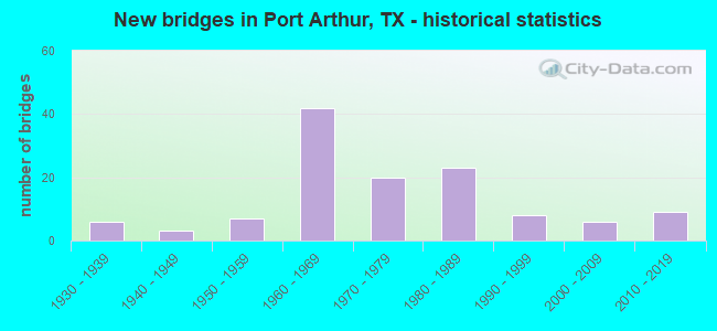
- New bridges - historical statistics
- 61930-1939
- 31940-1949
- 71950-1959
- 421960-1969
- 201970-1979
- 231980-1989
- 81990-1999
- 62000-2009
- 92010-2019
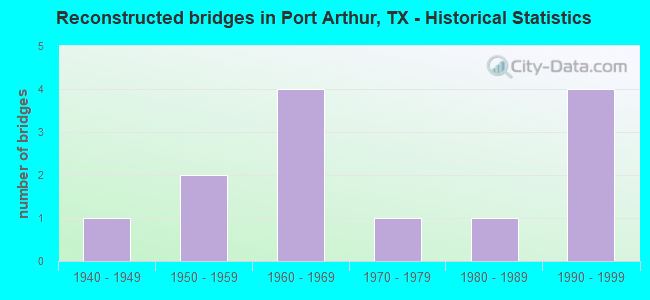
- Reconstructed bridges - Historical Statistics
- 11940-1949
- 21950-1959
- 41960-1969
- 11970-1979
- 11980-1989
- 41990-1999

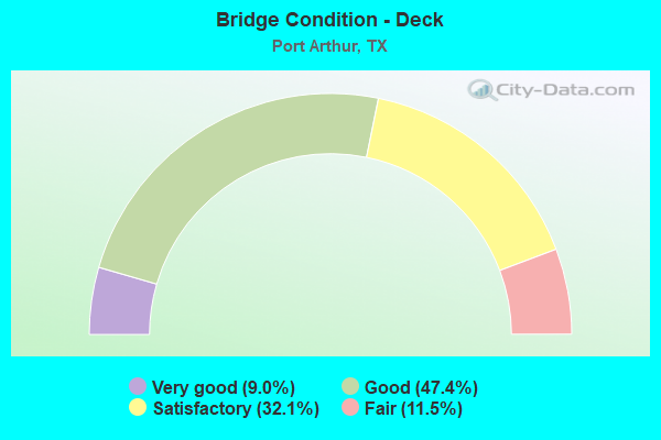
- Bridge Condition - Deck
- 9.0%Very good
- 47.4%Good
- 32.1%Satisfactory
- 11.5%Fair
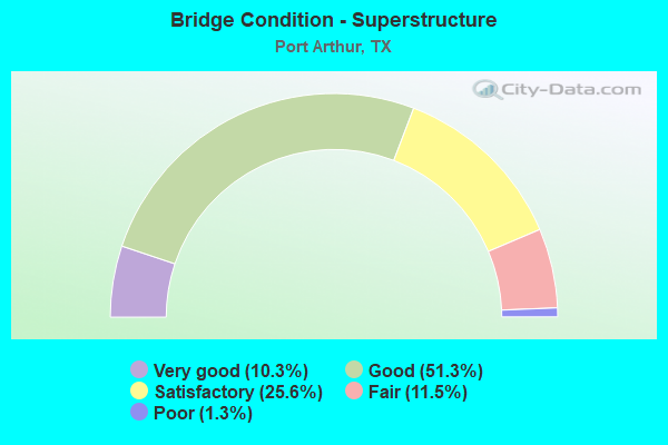
- Bridge Condition - Superstructure
- 10.3%Very good
- 51.3%Good
- 25.6%Satisfactory
- 11.5%Fair
- 1.3%Poor
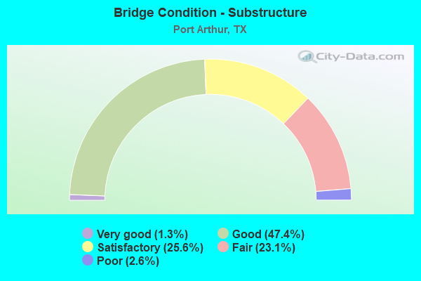
- Bridge Condition - Substructure
- 1.3%Very good
- 47.4%Good
- 25.6%Satisfactory
- 23.1%Fair
- 2.6%Poor
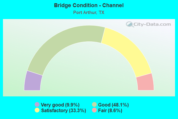
- Bridge Condition - Channel
- 9.9%Very good
- 48.1%Good
- 33.3%Satisfactory
- 8.6%Fair
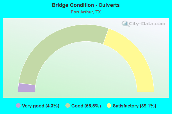
- Bridge Condition - Culverts
- 4.3%Very good
- 56.5%Good
- 39.1%Satisfactory
Find on map >> Show street view
Structure Number: 201240050804199, Location: 0.8 MI NE OF US 69 (Lat: 29.925792, Lng: -93.945569), Route carried "on" structure: State highway 73, Year Built: 1968, Status: Open, Structure Length: 7.62m (25.00ft), Average Daily Traffic: 13,645 (year 2020), Truck Traffic: 4%, Average Future Daily Traffic: 34,134 (year 2038), Design Load: HS 20, Features Intersected: 9TH AVE
Minimum Vertical Clearance: 30+ m (98+ ft), Kilometerpoint: 46.103, Lanes on structure: 2, Lanes under structure: 6, Owner: State Highway Agency, Approaching Roadway Width: 11.6m (38.1ft), Material/Design: Prestressed concrete, Design/Construction: Stringer/Multi-beam, Number Of Spans In Main Unit: 2, Number Of Approach Spans: 4, Length of Maximum Span: 13.7m (44.9ft), Curb-To-Curb Width: 12.3m (40.4ft), Out-to-Out Width: 12.9m (42.3ft)
Condition: Deck: Good, Superstructure: Good, Substructure: Good, Operating Rating: 58.0 metric tons, Method Used To Determine Operating Rating: Load Factor (LF), Inventory Rating: 34.5 metric tons, Method Used To Determine Inventory Rating: Load Factor (LF), Structural Evaluation: Better than present minimum criteria, Deck Geometry: Better than present minimum criteria, Underclear: Better than present minimum criteria, Approach Roadway Alignment: Equal to present desirable criteria, Designated Inspection Frequency: Every 24 months, Inspection Date: July 2020, Deck Structure Type: Concrete Cast-file-Place, Wearing Surface/Protective System: Wearing Surface: Bituminous
Find on map >> Show street view
Structure Number: 2012400508042, Location: 0.8 MI NE OF US 69 (Lat: 29.926233, Lng: -93.945531), Route carried "on" structure: State highway 73, Year Built: 1968, Status: Open, Structure Length: 7.62m (25.00ft), Average Daily Traffic: 14,530 (year 2020), Truck Traffic: 4%, Average Future Daily Traffic: 34,134 (year 2038), Design Load: HS 20, Features Intersected: 9TH AVE
Minimum Vertical Clearance: 30+ m (98+ ft), Kilometerpoint: 46.103, Lanes on structure: 2, Lanes under structure: 6, Owner: State Highway Agency, Approaching Roadway Width: 11.6m (38.1ft), Material/Design: Prestressed concrete, Design/Construction: Stringer/Multi-beam, Number Of Spans In Main Unit: 2, Number Of Approach Spans: 4, Length of Maximum Span: 13.7m (44.9ft), Curb-To-Curb Width: 12.3m (40.4ft), Out-to-Out Width: 12.9m (42.3ft)
Condition: Deck: Good, Superstructure: Good, Substructure: Satisfactory, Operating Rating: 58.0 metric tons, Method Used To Determine Operating Rating: Load Factor (LF), Inventory Rating: 34.5 metric tons, Method Used To Determine Inventory Rating: Load Factor (LF), Structural Evaluation: Equal to present minimum criteria, Deck Geometry: Better than present minimum criteria, Underclear: Equal to present minimum criteria, Approach Roadway Alignment: Equal to present desirable criteria, Designated Inspection Frequency: Every 24 months, Inspection Date: July 2020, Deck Structure Type: Concrete Cast-file-Place, Wearing Surface/Protective System: Wearing Surface: Bituminous
Find on map >> Show street view
Structure Number: 201240050804201, Location: 0.50 MI NW OF SH 347 (Lat: 29.930378, Lng: -93.939428), Route carried "on" structure: State highway 73, Year Built: 1968, Status: Open, Structure Length: 12.50m (41.01ft), Average Daily Traffic: 13,645 (year 2020), Truck Traffic: 8%, Average Future Daily Traffic: 34,134 (year 2038), Design Load: HS 20, Features Intersected: KCS RAILROAD
Minimum Vertical Clearance: 30+ m (98+ ft), Kilometerpoint: 46.871, Lanes on structure: 3, Owner: State Highway Agency, Approaching Roadway Width: 11.6m (38.1ft), Material/Design: Prestressed concrete, Design/Construction: Stringer/Multi-beam, Number Of Spans In Main Unit: 2, Number Of Approach Spans: 4, Length of Maximum Span: 22.9m (75.1ft), Curb-To-Curb Width: 14.8m (48.6ft), Out-to-Out Width: 15.3m (50.2ft)
Condition: Deck: Fair, Superstructure: Fair, Substructure: Poor, Channel: Good, Operating Rating: 68.0 metric tons, Method Used To Determine Operating Rating: Load Factor (LF), Inventory Rating: 38.1 metric tons, Method Used To Determine Inventory Rating: Load Factor (LF), Structural Evaluation: Meets minimum limits, Deck Geometry: Meets minimum limits, Underclear: Equal to present minimum criteria, Waterway Adequacy: Superior to present desirable criteria, Approach Roadway Alignment: Equal to present desirable criteria, Length Of Structure Improvement: 12.50m (41.01ft), Designated Inspection Frequency: Every 24 months, Inspection Date: July 2020, Bridge Improvement Cost: $39,000, Roadway Improvement Cost: $10,000, Total Project Cost: $49,000, Deck Structure Type: Concrete Cast-file-Place, Wearing Surface/Protective System: Wearing Surface: Bituminous
Find on map >> Show street view
Structure Number: 201240050804202, Location: 0.50 MI NW OF SH 347 (Lat: 29.930550, Lng: -93.939581), Route carried "on" structure: State highway 73, Year Built: 1968, Status: Open, Structure Length: 12.50m (41.01ft), Average Daily Traffic: 14,530 (year 2020), Truck Traffic: 4%, Average Future Daily Traffic: 34,134 (year 2038), Design Load: HS 20, Features Intersected: KCS RAILROAD
Minimum Vertical Clearance: 30+ m (98+ ft), Kilometerpoint: 46.871, Lanes on structure: 3, Owner: State Highway Agency, Approaching Roadway Width: 14.6m (47.9ft), Material/Design: Prestressed concrete, Design/Construction: Stringer/Multi-beam, Number Of Spans In Main Unit: 2, Number Of Approach Spans: 4, Length of Maximum Span: 22.9m (75.1ft), Curb-To-Curb Width: 14.8m (48.6ft), Out-to-Out Width: 15.3m (50.2ft)
Condition: Deck: Fair, Superstructure: Fair, Substructure: Poor, Channel: Good, Operating Rating: 68.0 metric tons, Method Used To Determine Operating Rating: Load Factor (LF), Inventory Rating: 38.1 metric tons, Method Used To Determine Inventory Rating: Load Factor (LF), Structural Evaluation: Meets minimum limits, Deck Geometry: Meets minimum limits, Underclear: Better than present minimum criteria, Waterway Adequacy: Superior to present desirable criteria, Approach Roadway Alignment: Equal to present desirable criteria, Designated Inspection Frequency: Every 24 months, Inspection Date: July 2020, Deck Structure Type: Concrete Cast-file-Place, Wearing Surface/Protective System: Wearing Surface: Bituminous
Find on map >> Show street view
Structure Number: 201240050804203, Location: 1.80 MI NE OF US 96 (Lat: 29.935308, Lng: -93.932694), Route carried "on" structure: State highway 73, Year Built: 1968, Status: Open, Structure Length: 7.32m (24.02ft), Average Daily Traffic: 16,146 (year 2018), Truck Traffic: 5%, Average Future Daily Traffic: 22,605 (year 2038), Design Load: HS 20, Features Intersected: SH 347
Minimum Vertical Clearance: 30+ m (98+ ft), Kilometerpoint: 47.740, Lanes on structure: 2, Lanes under structure: 8, Owner: State Highway Agency, Approaching Roadway Width: 11.6m (38.1ft), Skew: 1 degrees, Material/Design: Prestressed concrete, Design/Construction: Stringer/Multi-beam, Number Of Spans In Main Unit: 4, Length of Maximum Span: 19.8m (65.0ft), Curb-To-Curb Width: 12.4m (40.7ft), Out-to-Out Width: 12.9m (42.3ft)
Condition: Deck: Satisfactory, Superstructure: Satisfactory, Substructure: Fair, Operating Rating: 66.2 metric tons, Method Used To Determine Operating Rating: Load Factor (LF), Inventory Rating: 39.9 metric tons, Method Used To Determine Inventory Rating: Load Factor (LF), Structural Evaluation: Somewhat better than minimum adequacy, Deck Geometry: Better than present minimum criteria, Underclear: Meets minimum limits, Approach Roadway Alignment: Equal to present desirable criteria, Designated Inspection Frequency: Every 24 months, Inspection Date: July 2020, Deck Structure Type: Concrete Cast-file-Place, Wearing Surface/Protective System: Wearing Surface: Bituminous
Find on map >> Show street view
Structure Number: 201240050804204, Location: 1.80 MI NE OF US 96 (Lat: 29.935431, Lng: -93.932856), Route carried "on" structure: State highway 73, Year Built: 1968, Status: Open, Structure Length: 7.32m (24.02ft), Average Daily Traffic: 16,146 (year 2018), Truck Traffic: 5%, Average Future Daily Traffic: 22,605 (year 2038), Design Load: HS 20, Features Intersected: SH 347
Minimum Vertical Clearance: 30+ m (98+ ft), Kilometerpoint: 47.736, Lanes on structure: 2, Lanes under structure: 8, Owner: State Highway Agency, Approaching Roadway Width: 11.6m (38.1ft), Skew: 1 degrees, Material/Design: Prestressed concrete, Design/Construction: Stringer/Multi-beam, Number Of Spans In Main Unit: 4, Length of Maximum Span: 19.8m (65.0ft), Curb-To-Curb Width: 12.4m (40.7ft), Out-to-Out Width: 12.9m (42.3ft)
Condition: Deck: Satisfactory, Superstructure: Satisfactory, Substructure: Fair, Operating Rating: 66.2 metric tons, Method Used To Determine Operating Rating: Load Factor (LF), Inventory Rating: 39.9 metric tons, Method Used To Determine Inventory Rating: Load Factor (LF), Structural Evaluation: Somewhat better than minimum adequacy, Deck Geometry: Better than present minimum criteria, Underclear: Meets minimum limits, Approach Roadway Alignment: Equal to present desirable criteria, Designated Inspection Frequency: Every 24 months, Inspection Date: July 2020, Deck Structure Type: Concrete Cast-file-Place, Wearing Surface/Protective System: Wearing Surface: Bituminous
Find on map >> Show street view
Structure Number: 201240050804236, Location: 0.4 MI SW OF FM 366 (Lat: 29.943086, Lng: -93.890733), Route carried "on" structure: State highway 73, Year Built: 1972, Status: Open, Structure Length: 11.58m (37.99ft), Average Daily Traffic: 10,210 (year 2013), Truck Traffic: 9%, Average Future Daily Traffic: 14,290 (year 2033), Design Load: HS 20, Features Intersected: TAFT AVE; DRAINAGE DITCH
Minimum Vertical Clearance: 30+ m (98+ ft), Kilometerpoint: 52.103, Lanes on structure: 2, Lanes under structure: 8, Owner: State Highway Agency, Approaching Roadway Width: 11.6m (38.1ft), Material/Design: Prestressed concrete, Design/Construction: Stringer/Multi-beam, Number Of Spans In Main Unit: 3, Number Of Approach Spans: 1, Length of Maximum Span: 33.5m (109.9ft), Curb-To-Curb Width: 12.8m (42.0ft), Out-to-Out Width: 13.5m (44.3ft)
Condition: Deck: Good, Superstructure: Good, Substructure: Fair, Channel: Good, Operating Rating: 59.9 metric tons, Method Used To Determine Operating Rating: Load Factor (LF), Inventory Rating: 35.4 metric tons, Method Used To Determine Inventory Rating: Load Factor (LF), Structural Evaluation: Somewhat better than minimum adequacy, Deck Geometry: Equal to present desirable criteria, Underclear: Better than present minimum criteria, Waterway Adequacy: Superior to present desirable criteria, Approach Roadway Alignment: Equal to present desirable criteria, Designated Inspection Frequency: Every 24 months, Inspection Date: July 2020, Deck Structure Type: Concrete Cast-file-Place, Wearing Surface/Protective System: Wearing Surface: Bituminous
Find on map >> Show street view
Structure Number: 201240050804237, Location: 0.4 MI SW OF FM 366 (Lat: 29.942981, Lng: -93.890561), Route carried "on" structure: State highway 73, Year Built: 1972, Status: Open, Structure Length: 11.58m (37.99ft), Average Daily Traffic: 9,258 (year 2020), Truck Traffic: 9%, Average Future Daily Traffic: 14,290 (year 2033), Design Load: HS 20, Features Intersected: TAFT AVE; DRAINAGE DITCH
Minimum Vertical Clearance: 30+ m (98+ ft), Kilometerpoint: 52.104, Lanes on structure: 2, Lanes under structure: 8, Owner: State Highway Agency, Approaching Roadway Width: 11.6m (38.1ft), Material/Design: Prestressed concrete, Design/Construction: Stringer/Multi-beam, Number Of Spans In Main Unit: 3, Number Of Approach Spans: 1, Length of Maximum Span: 33.5m (109.9ft), Curb-To-Curb Width: 13.0m (42.7ft), Out-to-Out Width: 13.5m (44.3ft)
Condition: Deck: Good, Superstructure: Good, Substructure: Fair, Channel: Good, Operating Rating: 59.9 metric tons, Method Used To Determine Operating Rating: Load Factor (LF), Inventory Rating: 35.4 metric tons, Method Used To Determine Inventory Rating: Load Factor (LF), Structural Evaluation: Somewhat better than minimum adequacy, Deck Geometry: Superior to present desirable criteria, Underclear: Better than present minimum criteria, Waterway Adequacy: Superior to present desirable criteria, Approach Roadway Alignment: Equal to present desirable criteria, Designated Inspection Frequency: Every 24 months, Inspection Date: July 2020, Deck Structure Type: Concrete Cast-file-Place, Wearing Surface/Protective System: Wearing Surface: Bituminous
Find on map >> Show street view
Structure Number: 201240050804238, Location: 0.6 MI SW OF FM 366 (Lat: 29.941008, Lng: -93.893383), Route carried "on" structure: State highway 87, Year Built: 1972, Status: Open, Structure Length: 11.58m (37.99ft), Average Daily Traffic: 11,040 (year 2013), Truck Traffic: 8%, Average Future Daily Traffic: 15,460 (year 2033), Design Load: HS 20, Features Intersected: SH 73
Minimum Vertical Clearance: 4.90m (16.08ft), Kilometerpoint: 6.986, Lanes on structure: 2, Lanes under structure: 5, Owner: State Highway Agency, Approaching Roadway Width: 11.6m (38.1ft), Skew: 4 degrees, Material/Design: Prestressed concrete, Design/Construction: Stringer/Multi-beam, Number Of Spans In Main Unit: 2, Number Of Approach Spans: 2, Length of Maximum Span: 39.6m (129.9ft), Curb-To-Curb Width: 12.8m (42.0ft), Out-to-Out Width: 13.5m (44.3ft)
Condition: Deck: Good, Superstructure: Satisfactory, Substructure: Satisfactory, Operating Rating: 68.0 metric tons, Method Used To Determine Operating Rating: Load Factor (LF), Inventory Rating: 38.1 metric tons, Method Used To Determine Inventory Rating: Load Factor (LF), Structural Evaluation: Equal to present minimum criteria, Deck Geometry: Equal to present desirable criteria, Underclear: Somewhat better than minimum adequacy, Approach Roadway Alignment: Equal to present desirable criteria, Designated Inspection Frequency: Every 24 months, Inspection Date: July 2020, Deck Structure Type: Concrete Cast-file-Place
Find on map >> Show street view
Structure Number: 201240050804271, Location: 1.2 MI W OF FM 823 (Lat: 29.887675, Lng: -94.024761), Route carried "on" structure: State highway 73, Year Built: 1980, Status: Open, Structure Length: 2.50m (8.20ft), Average Daily Traffic: 10,166 (year 2016), Truck Traffic: 9%, Average Future Daily Traffic: 7,700 (year 2033), Design Load: HS 20, Features Intersected: S PORT ACRES DITCH
Minimum Vertical Clearance: 30+ m (98+ ft), Kilometerpoint: 36.159, Lanes on structure: 2, Owner: State Highway Agency, Approaching Roadway Width: 11.6m (38.1ft), Material/Design: Prestressed concrete, Design/Construction: Stringer/Multi-beam, Number Of Spans In Main Unit: 1, Length of Maximum Span: 25.0m (82.0ft), Curb-To-Curb Width: 11.7m (38.4ft), Out-to-Out Width: 12.3m (40.4ft)
Condition: Deck: Good, Superstructure: Good, Substructure: Good, Channel: Good, Operating Rating: 54.4 metric tons, Method Used To Determine Operating Rating: Assigned rating based on Load Factor Design (LFD) reported in metric tons, Inventory Rating: 32.7 metric tons, Method Used To Determine Inventory Rating: Assigned rating based on Load Factor Design (LFD) reported in metric tons, Structural Evaluation: Better than present minimum criteria, Deck Geometry: Better than present minimum criteria, Waterway Adequacy: Equal to present minimum criteria, Approach Roadway Alignment: Equal to present desirable criteria, Designated Inspection Frequency: Every 24 months, Inspection Date: July 2020, Deck Structure Type: Concrete Cast-file-Place
Find on map >> Show street view
Structure Number: 201240050804344, Location: 0.6 MI SW OF US 69 (Lat: 29.911242, Lng: -93.962106), Route carried "on" structure: State highway 73, Year Built: 1999, Status: Open, Structure Length: 7.80m (25.59ft), Average Daily Traffic: 23,757 (year 2020), Truck Traffic: 8%, Average Future Daily Traffic: 42,060 (year 2033), Design Load: HS 20, Features Intersected: MAIN B CANAL
Minimum Vertical Clearance: 30+ m (98+ ft), Kilometerpoint: 43.848, Lanes on structure: 4, Owner: State Highway Agency, Approaching Roadway Width: 23.2m (76.1ft), Skew: 30 degrees, Material/Design: Prestressed concrete, Design/Construction: Stringer/Multi-beam, Number Of Spans In Main Unit: 3, Length of Maximum Span: 25.9m (85.0ft), Curb-To-Curb Width: 22.6m (74.1ft), Out-to-Out Width: 24.1m (79.1ft)
Condition: Deck: Good, Superstructure: Good, Substructure: Good, Channel: Satisfactory, Operating Rating: 54.4 metric tons, Method Used To Determine Operating Rating: Assigned rating based on Load Factor Design (LFD) reported in metric tons, Inventory Rating: 32.7 metric tons, Method Used To Determine Inventory Rating: Assigned rating based on Load Factor Design (LFD) reported in metric tons, Structural Evaluation: Better than present minimum criteria, Deck Geometry: Superior to present desirable criteria, Waterway Adequacy: Superior to present desirable criteria, Approach Roadway Alignment: Equal to present desirable criteria, Length Of Structure Improvement: 7.77m (25.49ft), Designated Inspection Frequency: Every 24 months, Underwater Inspection Frequency: Every 60 months, Inspection Date: July 2020, Underwater Inspection Date: August 2019, Bridge Improvement Cost: $187,000, Roadway Improvement Cost: $47,000, Total Project Cost: $234,000, Deck Structure Type: Concrete Cast-file-Place, Wearing Surface/Protective System: Wearing Surface: Bituminous
Find on map >> Show street view
Structure Number: 201240050804434, Location: 3.0 MI W OF SH 82 (Lat: 29.880042, Lng: -94.053833), Route carried "on" structure: State highway 73, Year Built: 1991, Status: Open, Structure Length: 75.59m (248.00ft), Average Daily Traffic: 4,891 (year 2020), Truck Traffic: 11%, Average Future Daily Traffic: 5,480 (year 2033), Design Load: HS 20, Features Intersected: TAYLOR'S BAYOU
Minimum Vertical Clearance: 30+ m (98+ ft), Kilometerpoint: 33.038, Lanes on structure: 2, Owner: State Highway Agency, Approaching Roadway Width: 11.6m (38.1ft), Material/Design: Prestressed concrete, Design/Construction: Box Beam or Girders - Multiple, Number Of Spans In Main Unit: 25, Number Of Approach Spans: 6, Length of Maximum Span: 30.5m (100.1ft), Curb-To-Curb Width: 11.4m (37.4ft), Out-to-Out Width: 12.2m (40.0ft)
Condition: Deck: Fair, Superstructure: Satisfactory, Substructure: Good, Channel: Very good, Operating Rating: 54.4 metric tons, Method Used To Determine Operating Rating: Assigned rating based on Load Factor Design (LFD) reported in metric tons, Inventory Rating: 32.7 metric tons, Method Used To Determine Inventory Rating: Assigned rating based on Load Factor Design (LFD) reported in metric tons, Structural Evaluation: Equal to present minimum criteria, Deck Geometry: Equal to present minimum criteria, Waterway Adequacy: Superior to present desirable criteria, Approach Roadway Alignment: Equal to present desirable criteria, Designated Inspection Frequency: Every 24 months, Inspection Date: July 2020, Deck Structure Type: Concrete Cast-file-Place
Find on map >> Show street view
Structure Number: 201240050804435, Location: 3.0 MI W OF SH 82 (Lat: 29.884544, Lng: -94.047972), Route carried "on" structure: State highway 73, Year Built: 2000, Status: Open, Structure Length: 75.59m (248.00ft), Average Daily Traffic: 7,560 (year 2016), Truck Traffic: 11%, Average Future Daily Traffic: 5,480 (year 2033), Design Load: HS 20, Features Intersected: TAYLOR'S BAYOU
Minimum Vertical Clearance: 30+ m (98+ ft), Kilometerpoint: 33.038, Lanes on structure: 2, Owner: State Highway Agency, Approaching Roadway Width: 11.6m (38.1ft), Material/Design: Prestressed concrete, Design/Construction: Box Beam or Girders - Multiple, Number Of Spans In Main Unit: 25, Number Of Approach Spans: 6, Length of Maximum Span: 30.5m (100.1ft), Curb-To-Curb Width: 11.4m (37.4ft), Out-to-Out Width: 12.2m (40.0ft)
Condition: Deck: Fair, Superstructure: Good, Substructure: Good, Channel: Good, Operating Rating: 54.4 metric tons, Method Used To Determine Operating Rating: Assigned rating based on Load Factor Design (LFD) reported in metric tons, Inventory Rating: 32.7 metric tons, Method Used To Determine Inventory Rating: Assigned rating based on Load Factor Design (LFD) reported in metric tons, Structural Evaluation: Better than present minimum criteria, Deck Geometry: Equal to present minimum criteria, Waterway Adequacy: Superior to present desirable criteria, Approach Roadway Alignment: Equal to present desirable criteria, Designated Inspection Frequency: Every 24 months, Inspection Date: July 2020, Deck Structure Type: Concrete Cast-file-Place
Find on map >> Show street view
Structure Number: 201240050804473, Location: SH 73 @ Taft (Lat: 29.943022, Lng: -93.889847), Route carried "on" structure: ServiceState highway 73, Year Built: 2012, Status: Open, Structure Length: 0.79m (2.59ft), Average Daily Traffic: 2,010 (year 2013), Truck Traffic: 9%, Average Future Daily Traffic: 2,810 (year 2033), Design Load: HL 93, Features Intersected: Atlantic Main Canal
Minimum Vertical Clearance: 30+ m (98+ ft), Kilometerpoint: 52.009, Lanes on structure: 2, Owner: State Highway Agency, Approaching Roadway Width: 9.8m (32.2ft), Material/Design: Concrete, Design/Construction: Culvert, Number Of Spans In Main Unit: 3, Length of Maximum Span: 2.4m (7.9ft)
Condition: Channel: Good, Culverts: Good, Operating Rating: 54.4 metric tons, Method Used To Determine Operating Rating: Assigned ratings based on Load and Resistance Factor Design (LRFD) reported in metric tons, Inventory Rating: 32.7 metric tons, Method Used To Determine Inventory Rating: Assigned ratings based on Load and Resistance Factor Design (LRFD) reported in metric tons, Structural Evaluation: Better than present minimum criteria, Waterway Adequacy: Equal to present minimum criteria, Approach Roadway Alignment: Equal to present desirable criteria, Designated Inspection Frequency: Every 48 months, Inspection Date: July 2020
Find on map >> Show street view
Structure Number: 201240050805341, Location: 1.2 MI SE OF SH 73 (Lat: 29.877706, Lng: -93.979117), Route carried "on" structure: State highway 82, Year Built: 2013, Status: Open, Structure Length: 9.39m (30.81ft), Average Daily Traffic: 13,582 (year 2020), Truck Traffic: 19%, Average Future Daily Traffic: 10,860 (year 2033), Design Load: HL 93, Features Intersected: Alligator Bayou
Minimum Vertical Clearance: 30+ m (98+ ft), Kilometerpoint: 4.350, Lanes on structure: 5, Owner: State Highway Agency, Approaching Roadway Width: 22.6m (74.1ft), Material/Design: Prestressed concrete, Design/Construction: Slab, Number Of Spans In Main Unit: 8, Length of Maximum Span: 13.1m (43.0ft), Curb-To-Curb Width: 22.4m (73.5ft), Out-to-Out Width: 23.3m (76.4ft)
Condition: Deck: Good, Superstructure: Very good, Substructure: Good, Channel: Very good, Operating Rating: 54.4 metric tons, Method Used To Determine Operating Rating: Assigned ratings based on Load and Resistance Factor Design (LRFD) reported in metric tons, Inventory Rating: 32.7 metric tons, Method Used To Determine Inventory Rating: Assigned ratings based on Load and Resistance Factor Design (LRFD) reported in metric tons, Structural Evaluation: Better than present minimum criteria, Deck Geometry: Meets minimum limits, Waterway Adequacy: Equal to present minimum criteria, Approach Roadway Alignment: Equal to present desirable criteria, Designated Inspection Frequency: Every 24 months, Inspection Date: July 2020, Deck Structure Type: Concrete Cast-file-Place
Find on map >> Show street view
Structure Number: 20124005080602, Location: 0.1 MI SE OF SH 73 (Lat: 29.903928, Lng: -93.967356), Route carried "on" structure: Spur State highway 215, Year Built: 1961, Status: Open, Structure Length: 7.41m (24.31ft), Average Daily Traffic: 9,055 (year 2020), Truck Traffic: 14%, Average Future Daily Traffic: 11,790 (year 2033), Features Intersected: MAIN OUTFALL CANAL
Minimum Vertical Clearance: 30+ m (98+ ft), Kilometerpoint: 1.745, Lanes on structure: 4, Owner: State Highway Agency, Approaching Roadway Width: 14.6m (47.9ft), Skew: 20 degrees, Material/Design: Concrete, Design/Construction: Stringer/Multi-beam, Number Of Spans In Main Unit: 8, Length of Maximum Span: 9.1m (29.9ft), Curb-To-Curb Width: 16.5m (54.1ft), Out-to-Out Width: 18.7m (61.4ft)
Condition: Deck: Fair, Superstructure: Fair, Substructure: Fair, Channel: Fair, Operating Rating: 68.0 metric tons, Method Used To Determine Operating Rating: Load Factor (LF), Inventory Rating: 40.8 metric tons, Method Used To Determine Inventory Rating: Load Factor (LF), Structural Evaluation: Somewhat better than minimum adequacy, Deck Geometry: Meets minimum limits, Waterway Adequacy: Equal to present minimum criteria, Approach Roadway Alignment: Equal to present desirable criteria, Designated Inspection Frequency: Every 24 months, Underwater Inspection Frequency: Every 60 months, Inspection Date: July 2020, Underwater Inspection Date: Febuary 2020, Deck Structure Type: Concrete Cast-file-Place
Find on map >> Show street view
Structure Number: 201240050806021, Location: 1.1 MI SE OF SH 73 (Lat: 29.894008, Lng: -93.953539), Route carried "on" structure: Spur State highway 215, Year Built: 1961, Year Reconstructed: 1990, Status: Open, Structure Length: 5.55m (18.21ft), Average Daily Traffic: 9,055 (year 2020), Truck Traffic: 14%, Average Future Daily Traffic: 11,790 (year 2033), Design Load: H 20, Features Intersected: ALLIGATOR BAYOU
Minimum Vertical Clearance: 30+ m (98+ ft), Kilometerpoint: 3.470, Lanes on structure: 4, Owner: State Highway Agency, Approaching Roadway Width: 14.6m (47.9ft), Material/Design: Concrete, Design/Construction: Stringer/Multi-beam, Number Of Spans In Main Unit: 6, Length of Maximum Span: 9.1m (29.9ft), Curb-To-Curb Width: 15.7m (51.5ft), Out-to-Out Width: 16.6m (54.5ft)
Condition: Deck: Satisfactory, Superstructure: Satisfactory, Substructure: Fair, Channel: Satisfactory, Operating Rating: 68.0 metric tons, Method Used To Determine Operating Rating: Load Factor (LF), Inventory Rating: 40.8 metric tons, Method Used To Determine Inventory Rating: Load Factor (LF), Structural Evaluation: Somewhat better than minimum adequacy, Deck Geometry: Meets minimum limits, Waterway Adequacy: Equal to present minimum criteria, Approach Roadway Alignment: Equal to present desirable criteria, Length Of Structure Improvement: 6.49m (21.29ft), Designated Inspection Frequency: Every 24 months, Underwater Inspection Frequency: Every 60 months, Inspection Date: July 2020, Underwater Inspection Date: Febuary 2017, Bridge Improvement Cost: $329,000, Roadway Improvement Cost: $82,000, Total Project Cost: $411,000, Deck Structure Type: Concrete Cast-file-Place
Find on map >> Show street view
Structure Number: 201240066701005, Location: 0.4 MI NW OF SPUR 136 (Lat: 29.951664, Lng: -93.955394), Route carried "on" structure: State highway 347, Year Built: 1963, Status: Open, Structure Length: 2.44m (8.01ft), Average Daily Traffic: 8,457 (year 2020), Truck Traffic: 9%, Average Future Daily Traffic: 11,310 (year 2033), Features Intersected: MAIN A CANAL
Minimum Vertical Clearance: 30+ m (98+ ft), Kilometerpoint: 12.711, Lanes on structure: 2, Owner: State Highway Agency, Approaching Roadway Width: 11.6m (38.1ft), Material/Design: Concrete continuous, Design/Construction: Slab, Number Of Spans In Main Unit: 3, Length of Maximum Span: 9.1m (29.9ft), Curb-To-Curb Width: 11.3m (37.1ft), Out-to-Out Width: 12.2m (40.0ft)
Condition: Deck: Satisfactory, Superstructure: Satisfactory, Substructure: Good, Channel: Good, Operating Rating: 55.3 metric tons, Method Used To Determine Operating Rating: Load Factor (LF), Inventory Rating: 32.7 metric tons, Method Used To Determine Inventory Rating: Load Factor (LF), Structural Evaluation: Equal to present minimum criteria, Deck Geometry: Equal to present minimum criteria, Waterway Adequacy: Equal to present minimum criteria, Approach Roadway Alignment: Equal to present desirable criteria, Designated Inspection Frequency: Every 24 months, Underwater Inspection Frequency: Every 60 months, Inspection Date: July 2020, Underwater Inspection Date: June 2021, Deck Structure Type: Concrete Cast-file-Place
Find on map >> Show street view
Structure Number: 20124006670101, Location: 3.4MI SE OF FM 366 INTERS (Lat: 29.954197, Lng: -93.960694), Route carried "on" structure: State highway 347, Year Built: 1965, Status: Open, Structure Length: 8.63m (28.31ft), Average Daily Traffic: 17,969 (year 2016), Truck Traffic: 9%, Average Future Daily Traffic: 11,310 (year 2033), Design Load: H 20, Features Intersected: KCS Railroad
Minimum Vertical Clearance: 30+ m (98+ ft), Kilometerpoint: 12.180, Lanes on structure: 2, Owner: State Highway Agency, Approaching Roadway Width: 11.6m (38.1ft), Skew: 6 degrees, Material/Design: Steel continuous, Design/Construction: Stringer/Multi-beam, Number Of Spans In Main Unit: 5, Length of Maximum Span: 24.4m (80.1ft), Curb-To-Curb Width: 11.7m (38.4ft), Out-to-Out Width: 12.3m (40.4ft)
Condition: Deck: Satisfactory, Superstructure: Satisfactory, Substructure: Satisfactory, Operating Rating: 62.6 metric tons, Method Used To Determine Operating Rating: Load Factor (LF), Inventory Rating: 37.2 metric tons, Method Used To Determine Inventory Rating: Load Factor (LF), Structural Evaluation: Equal to present minimum criteria, Deck Geometry: Better than present minimum criteria, Underclear: Equal to present minimum criteria, Approach Roadway Alignment: Equal to present desirable criteria, Designated Inspection Frequency: Every 24 months, Inspection Date: July 2020, Deck Structure Type: Concrete Cast-file-Place
Find on map >> Show street view
Structure Number: 201240066701011, Location: 3.4MI SE OF FM 366 INTERS (Lat: 29.953847, Lng: -93.960483), Route carried "on" structure: State highway 347, Year Built: 1965, Status: Open, Structure Length: 8.63m (28.31ft), Average Daily Traffic: 8,080 (year 2013), Truck Traffic: 9%, Average Future Daily Traffic: 11,310 (year 2033), Design Load: H 20, Features Intersected: KCS Railroad
Minimum Vertical Clearance: 30+ m (98+ ft), Kilometerpoint: 12.144, Lanes on structure: 2, Owner: State Highway Agency, Approaching Roadway Width: 11.6m (38.1ft), Skew: 6 degrees, Material/Design: Steel continuous, Design/Construction: Stringer/Multi-beam, Number Of Spans In Main Unit: 5, Length of Maximum Span: 24.4m (80.1ft), Curb-To-Curb Width: 11.7m (38.4ft), Out-to-Out Width: 12.3m (40.4ft)
Condition: Deck: Satisfactory, Superstructure: Satisfactory, Substructure: Satisfactory, Operating Rating: 62.6 metric tons, Method Used To Determine Operating Rating: Load Factor (LF), Inventory Rating: 37.2 metric tons, Method Used To Determine Inventory Rating: Load Factor (LF), Structural Evaluation: Equal to present minimum criteria, Deck Geometry: Better than present minimum criteria, Underclear: Better than present minimum criteria, Approach Roadway Alignment: Equal to present desirable criteria, Designated Inspection Frequency: Every 24 months, Inspection Date: July 2020, Deck Structure Type: Concrete Cast-file-Place
Find on map >> Show street view
Structure Number: 201240066701012, Location: 1.3 MILES NW of SH 73 (Lat: 29.947431, Lng: -93.949103), Route carried "on" structure: State highway 347, Year Built: 1983, Status: Open, Structure Length: 15.09m (49.51ft), Average Daily Traffic: 9,041 (year 2020), Truck Traffic: 9%, Average Future Daily Traffic: 12,220 (year 2033), Design Load: HS 20, Features Intersected: Spur 136 & KCS Railroad
Minimum Vertical Clearance: 30+ m (98+ ft), Kilometerpoint: 13.433, Lanes on structure: 3, Lanes under structure: 4, Owner: State Highway Agency, Approaching Roadway Width: 15.2m (49.9ft), Skew: 9 degrees, Material/Design: Prestressed concrete, Design/Construction: Stringer/Multi-beam, Number Of Spans In Main Unit: 3, Number Of Approach Spans: 3, Length of Maximum Span: 29.0m (95.1ft), Curb-To-Curb Width: 15.2m (49.9ft), Out-to-Out Width: 15.9m (52.2ft)
Condition: Deck: Fair, Superstructure: Good, Substructure: Satisfactory, Operating Rating: 54.4 metric tons, Method Used To Determine Operating Rating: Assigned rating based on Load Factor Design (LFD) reported in metric tons, Inventory Rating: 32.7 metric tons, Method Used To Determine Inventory Rating: Assigned rating based on Load Factor Design (LFD) reported in metric tons, Structural Evaluation: Equal to present minimum criteria, Deck Geometry: Equal to present minimum criteria, Underclear: Equal to present minimum criteria, Approach Roadway Alignment: Equal to present desirable criteria, Designated Inspection Frequency: Every 24 months, Inspection Date: July 2020, Deck Structure Type: Concrete Cast-file-Place
Find on map >> Show street view
Structure Number: 201240066701013, Location: SH 347 @ SPUR 136 (Lat: 29.947333, Lng: -93.949286), Route carried "on" structure: State highway 347, Year Built: 1983, Status: Open, Structure Length: 14.54m (47.70ft), Average Daily Traffic: 9,485 (year 2020), Truck Traffic: 9%, Average Future Daily Traffic: 12,220 (year 2033), Design Load: HS 20, Features Intersected: Spur 136 & KCS Railroad
Minimum Vertical Clearance: 30+ m (98+ ft), Kilometerpoint: 13.433, Lanes on structure: 3, Lanes under structure: 4, Owner: State Highway Agency, Approaching Roadway Width: 15.2m (49.9ft), Skew: 19 degrees, Material/Design: Prestressed concrete, Design/Construction: Stringer/Multi-beam, Number Of Spans In Main Unit: 3, Number Of Approach Spans: 3, Length of Maximum Span: 27.4m (89.9ft), Curb-To-Curb Width: 15.2m (49.9ft), Out-to-Out Width: 15.9m (52.2ft)
Condition: Deck: Satisfactory, Superstructure: Good, Substructure: Satisfactory, Operating Rating: 54.4 metric tons, Method Used To Determine Operating Rating: Assigned rating based on Load Factor Design (LFD) reported in metric tons, Inventory Rating: 32.7 metric tons, Method Used To Determine Inventory Rating: Assigned rating based on Load Factor Design (LFD) reported in metric tons, Structural Evaluation: Equal to present minimum criteria, Deck Geometry: Equal to present minimum criteria, Underclear: Better than present minimum criteria, Approach Roadway Alignment: Equal to present desirable criteria, Designated Inspection Frequency: Every 24 months, Inspection Date: July 2020, Deck Structure Type: Concrete Precast Panels
Find on map >> Show street view
Structure Number: 201240066701019, Location: SH 347 @ FM 365 (Lat: 29.965942, Lng: -93.975686), Route carried "on" structure: State highway 365, Year Built: 2001, Status: Open, Structure Length: 30.18m (99.02ft), Average Daily Traffic: 13,325 (year 2016), Truck Traffic: 3%, Average Future Daily Traffic: 24,510 (year 2033), Design Load: HS 20, Features Intersected: SH 347 & KCS Railroad
Minimum Vertical Clearance: 7.24m (23.75ft), Kilometerpoint: 29.651, Lanes on structure: 4, Lanes under structure: 9, Owner: State Highway Agency, Approaching Roadway Width: 25.6m (84.0ft), Skew: 9 degrees, Material/Design: Prestressed concrete, Design/Construction: Stringer/Multi-beam, Number Of Spans In Main Unit: 9, Length of Maximum Span: 36.0m (118.1ft), Curb-To-Curb Width: 25.4m (83.3ft), Out-to-Out Width: 26.2m (86.0ft)
Condition: Deck: Good, Superstructure: Good, Substructure: Satisfactory, Operating Rating: 54.4 metric tons, Method Used To Determine Operating Rating: Assigned rating based on Load Factor Design (LFD) reported in metric tons, Inventory Rating: 32.7 metric tons, Method Used To Determine Inventory Rating: Assigned rating based on Load Factor Design (LFD) reported in metric tons, Structural Evaluation: Equal to present minimum criteria, Deck Geometry: Superior to present desirable criteria, Underclear: Better than present minimum criteria, Approach Roadway Alignment: Equal to present desirable criteria, Designated Inspection Frequency: Every 24 months, Inspection Date: July 2020, Deck Structure Type: Concrete Precast Panels
Find on map >> Show street view
Structure Number: 201240066701205, Location: 0.4 MI NW OF SPUR 136 (Lat: 29.951575, Lng: -93.955794), Route carried "on" structure: State highway 347, Year Built: 2010, Status: Open, Structure Length: 2.68m (8.79ft), Average Daily Traffic: 8,969 (year 2020), Truck Traffic: 9%, Average Future Daily Traffic: 11,310 (year 2033), Design Load: HL 93, Features Intersected: MAIN A CANAL
Minimum Vertical Clearance: 30+ m (98+ ft), Kilometerpoint: 9.971, Lanes on structure: 2, Owner: State Highway Agency, Approaching Roadway Width: 11.6m (38.1ft), Material/Design: Prestressed concrete, Number Of Spans In Main Unit: 2, Length of Maximum Span: 13.4m (44.0ft), Curb-To-Curb Width: 11.6m (38.1ft), Out-to-Out Width: 12.2m (40.0ft)
Condition: Deck: Good, Superstructure: Very good, Substructure: Good, Channel: Good, Operating Rating: 54.4 metric tons, Method Used To Determine Operating Rating: Assigned ratings based on Load and Resistance Factor Design (LRFD) reported in metric tons, Inventory Rating: 32.7 metric tons, Method Used To Determine Inventory Rating: Assigned ratings based on Load and Resistance Factor Design (LRFD) reported in metric tons, Structural Evaluation: Better than present minimum criteria, Deck Geometry: Better than present minimum criteria, Waterway Adequacy: Equal to present minimum criteria, Approach Roadway Alignment: Equal to present desirable criteria, Designated Inspection Frequency: Every 24 months, Inspection Date: July 2020, Deck Structure Type: Concrete Cast-file-Place
Find on map >> Show street view
Structure Number: 201240093201009, Location: 0.05 MI E OF SPUR 93 (Lat: 29.919267, Lng: -94.019494), Route carried "on" structure: State highway 365, Year Built: 1951, Status: Open, Structure Length: 0.79m (2.59ft), Average Daily Traffic: 8,849 (year 2016), Truck Traffic: 11%, Average Future Daily Traffic: 9,460 (year 2033), Design Load: H 15, Features Intersected: LNVA CANAL
Minimum Vertical Clearance: 30+ m (98+ ft), Kilometerpoint: 23.086, Lanes on structure: 3, Owner: State Highway Agency, Approaching Roadway Width: 12.8m (42.0ft), Skew: 3 degrees, Material/Design: Concrete, Design/Construction: Culvert, Number Of Spans In Main Unit: 4, Length of Maximum Span: 1.5m (4.9ft), Curb-To-Curb Width: 13.5m (44.3ft), Out-to-Out Width: 14.3m (46.9ft)
Condition: Channel: Good, Culverts: Good, Operating Rating: 39.9 metric tons, Method Used To Determine Operating Rating: Load Factor (LF), Inventory Rating: 23.6 metric tons, Method Used To Determine Inventory Rating: Load Factor (LF), Structural Evaluation: Somewhat better than minimum adequacy, Deck Geometry: Somewhat better than minimum adequacy, Waterway Adequacy: Equal to present minimum criteria, Approach Roadway Alignment: Equal to present desirable criteria, Designated Inspection Frequency: Every 24 months, Inspection Date: July 2020
Find on map >> Show street view
Structure Number: 201240093201011, Location: 5.4 MI SW OF US 69,96,287 (Lat: 29.913761, Lng: -94.068525), Route carried "on" structure: State highway 365, Year Built: 1953, Status: Not yet open, Structure Length: 23.77m (77.99ft), Average Daily Traffic: 5,021 (year 2016), Truck Traffic: 4%, Average Future Daily Traffic: 5,710 (year 2033), Design Load: H 20, Features Intersected: HILLEBRANDT BAYOU
Minimum Vertical Clearance: 30+ m (98+ ft), Kilometerpoint: 18.002, Lanes on structure: 2, Owner: State Highway Agency, Approaching Roadway Width: 6.7m (22.0ft), Design/Construction: Movable - Swing, Number Of Spans In Main Unit: 1, Number Of Approach Spans: 24, Length of Maximum Span: 18.3m (60.0ft), Curb-To-Curb Width: 7.8m (25.6ft), Out-to-Out Width: 8.9m (29.2ft)
Condition: Deck: Fair, Superstructure: Fair, Substructure: Fair, Channel: Good, Operating Rating: 32.7 metric tons, Method Used To Determine Operating Rating: Load Factor (LF), Inventory Rating: 19.0 metric tons, Method Used To Determine Inventory Rating: Load Factor (LF), Structural Evaluation: Meets minimum limits, Deck Geometry: High priority of replacement, Waterway Adequacy: Equal to present minimum criteria, Approach Roadway Alignment: Equal to present desirable criteria, Length Of Structure Improvement: 24.99m (81.99ft), Designated Inspection Frequency: Every 24 months, Critical Feature Inspection Frequency: Every 24 months, Underwater Inspection Frequency: Every 60 months, Inspection Date: July 2020, Critical Feature Inspection Date: March 2020, Underwater Inspection Date: Febuary 2017, Bridge Improvement Cost: $1,264,000, Roadway Improvement Cost: $316,000, Total Project Cost: $1,580,000, Deck Structure Type: Open Grating
Find on map >> Show street view
Structure Number: 201240093201012, Location: 1.4 MI W OF UP RR (Lat: 29.914175, Lng: -94.041461), Route carried "on" structure: State highway 365, Year Built: 1953, Status: Open, Structure Length: 17.37m (56.99ft), Average Daily Traffic: 5,021 (year 2016), Truck Traffic: 4%, Average Future Daily Traffic: 5,710 (year 2033), Design Load: H 20, Features Intersected: RHODAIR GULLY
Minimum Vertical Clearance: 30+ m (98+ ft), Kilometerpoint: 20.641, Lanes on structure: 2, Owner: State Highway Agency, Approaching Roadway Width: 9.8m (32.2ft), Material/Design: Concrete, Design/Construction: Stringer/Multi-beam, Number Of Spans In Main Unit: 19, Length of Maximum Span: 9.1m (29.9ft), Curb-To-Curb Width: 7.9m (25.9ft), Out-to-Out Width: 8.9m (29.2ft)
Condition: Deck: Satisfactory, Superstructure: Fair, Substructure: Fair, Channel: Good, Operating Rating: 63.5 metric tons, Method Used To Determine Operating Rating: Load Factor (LF), Inventory Rating: 37.2 metric tons, Method Used To Determine Inventory Rating: Load Factor (LF), Structural Evaluation: Somewhat better than minimum adequacy, Deck Geometry: High priority of corrective action, Waterway Adequacy: Equal to present minimum criteria, Approach Roadway Alignment: Equal to present desirable criteria, Length Of Structure Improvement: 17.37m (56.99ft), Designated Inspection Frequency: Every 24 months, Underwater Inspection Frequency: Every 60 months, Inspection Date: July 2020, Underwater Inspection Date: Febuary 2020, Bridge Improvement Cost: $30,000, Roadway Improvement Cost: $8,000, Total Project Cost: $38,000, Deck Structure Type: Concrete Cast-file-Place
Find on map >> Show street view
Structure Number: 201240093201014, Location: 0.4 MI SW OF SH 347 (Lat: 29.961236, Lng: -93.980133), Route carried "on" structure: State highway 365, Year Built: 1956, Year Reconstructed: 2001, Status: Open, Structure Length: 0.98m (3.22ft), Average Daily Traffic: 22,034 (year 2020), Truck Traffic: 3%, Average Future Daily Traffic: 24,510 (year 2033), Features Intersected: MAIN B CANAL
Minimum Vertical Clearance: 30+ m (98+ ft), Kilometerpoint: 29.074, Lanes on structure: 6, Owner: State Highway Agency, Approaching Roadway Width: 25.6m (84.0ft), Skew: 9 degrees, Material/Design: Concrete, Design/Construction: Culvert, Number Of Spans In Main Unit: 4, Length of Maximum Span: 2.1m (6.9ft)
Condition: Channel: Satisfactory, Culverts: Satisfactory, Operating Rating: 39.9 metric tons, Method Used To Determine Operating Rating: Load Factor (LF), Inventory Rating: 23.6 metric tons, Method Used To Determine Inventory Rating: Load Factor (LF), Structural Evaluation: Somewhat better than minimum adequacy, Waterway Adequacy: Superior to present desirable criteria, Approach Roadway Alignment: Equal to present desirable criteria, Designated Inspection Frequency: Every 24 months, Inspection Date: July 2020
Find on map >> Show street view
Structure Number: 201240093201017, Location: 3.9 MI W OF SP 93 (Lat: 29.913550, Lng: -94.083744), Route carried "on" structure: State highway 365, Year Built: 1970, Status: Open, Structure Length: 1.22m (4.00ft), Average Daily Traffic: 5,021 (year 2016), Truck Traffic: 4%, Average Future Daily Traffic: 5,710 (year 2033), Features Intersected: LNVA CANAL
Minimum Vertical Clearance: 30+ m (98+ ft), Kilometerpoint: 16.626, Lanes on structure: 2, Owner: State Highway Agency, Approaching Roadway Width: 12.2m (40.0ft), Skew: 4 degrees, Material/Design: Concrete, Design/Construction: Culvert, Number Of Spans In Main Unit: 4, Length of Maximum Span: 2.4m (7.9ft)
Condition: Channel: Good, Culverts: Good, Operating Rating: 39.9 metric tons, Method Used To Determine Operating Rating: Load Factor (LF), Inventory Rating: 23.6 metric tons, Method Used To Determine Inventory Rating: Load Factor (LF), Structural Evaluation: Somewhat better than minimum adequacy, Waterway Adequacy: Equal to present minimum criteria, Approach Roadway Alignment: Equal to present desirable criteria, Designated Inspection Frequency: Every 24 months, Inspection Date: July 2020
Find on map >> Show street view
Structure Number: 201240093201018, Location: 1.2 MI W OF SPUR 93 (Lat: 29.914267, Lng: -94.038592), Route carried "on" structure: State highway 365, Year Built: 1971, Status: Open, Structure Length: 1.16m (3.81ft), Average Daily Traffic: 5,021 (year 2016), Truck Traffic: 4%, Average Future Daily Traffic: 5,710 (year 2033), Design Load: H 20, Features Intersected: DRAINAGE DITCH
Minimum Vertical Clearance: 30+ m (98+ ft), Kilometerpoint: 21.008, Lanes on structure: 2, Owner: State Highway Agency, Approaching Roadway Width: 13.4m (44.0ft), Material/Design: Concrete, Design/Construction: Culvert, Number Of Spans In Main Unit: 5, Length of Maximum Span: 1.8m (5.9ft)
Condition: Channel: Satisfactory, Culverts: Good, Operating Rating: 39.9 metric tons, Method Used To Determine Operating Rating: Load Factor (LF), Inventory Rating: 23.6 metric tons, Method Used To Determine Inventory Rating: Load Factor (LF), Structural Evaluation: Somewhat better than minimum adequacy, Waterway Adequacy: Equal to present minimum criteria, Approach Roadway Alignment: Equal to present desirable criteria, Designated Inspection Frequency: Every 24 months, Inspection Date: July 2020
Find on map >> Show street view
Structure Number: 201240093201142, Location: 1.1 MI SW of US 69,96,287 (Lat: 29.933464, Lng: -94.005961), Route carried "on" structure: State highway 365, Year Built: 2012, Status: Open, Structure Length: 4.51m (14.80ft), Average Daily Traffic: 11,573 (year 2020), Truck Traffic: 11%, Average Future Daily Traffic: 16,490 (year 2033), Design Load: HS 20, Features Intersected: MAIN C CANAL
Minimum Vertical Clearance: 30+ m (98+ ft), Kilometerpoint: 25.117, Lanes on structure: 5, Owner: State Highway Agency, Approaching Roadway Width: 23.8m (78.1ft), Skew: 2 degrees, Material/Design: Concrete, Design/Construction: Stringer/Multi-beam, Number Of Spans In Main Unit: 2, Number Of Approach Spans: 2, Length of Maximum Span: 12.8m (42.0ft), Curb-To-Curb Width: 23.8m (78.1ft), Out-to-Out Width: 24.4m (80.1ft)
Condition: Deck: Good, Superstructure: Good, Substructure: Good, Channel: Good, Operating Rating: 54.4 metric tons, Method Used To Determine Operating Rating: Assigned rating based on Load Factor Design (LFD) reported in metric tons, Inventory Rating: 32.7 metric tons, Method Used To Determine Inventory Rating: Assigned rating based on Load Factor Design (LFD) reported in metric tons, Structural Evaluation: Better than present minimum criteria, Deck Geometry: Better than present minimum criteria, Waterway Adequacy: Equal to present desirable criteria, Approach Roadway Alignment: Equal to present desirable criteria, Designated Inspection Frequency: Every 24 months, Inspection Date: June 2020, Deck Structure Type: Concrete Cast-file-Place
Find on map >> Show street view
Structure Number: 201240107501004, Location: 2.6 MI S OF FM 3514 (Lat: 29.957683, Lng: -94.044194), Route carried "on" structure: Spur State highway 93, Year Built: 2002, Status: Open, Structure Length: 2.74m (8.99ft), Average Daily Traffic: 7,659 (year 2016), Truck Traffic: 9%, Average Future Daily Traffic: 7,940 (year 2033), Design Load: HS 20, Features Intersected: RHODAIR GULLY
Minimum Vertical Clearance: 30+ m (98+ ft), Kilometerpoint: 9.387, Lanes on structure: 4, Owner: State Highway Agency, Approaching Roadway Width: 14.0m (45.9ft), Skew: 4 degrees, Material/Design: Prestressed concrete, Design/Construction: Box Beam or Girders - Multiple, Number Of Spans In Main Unit: 2, Length of Maximum Span: 13.7m (44.9ft), Curb-To-Curb Width: 13.9m (45.6ft), Out-to-Out Width: 14.7m (48.2ft)
Condition: Deck: Good, Superstructure: Good, Substructure: Good, Channel: Good, Operating Rating: 54.4 metric tons, Method Used To Determine Operating Rating: Assigned rating based on Load Factor Design (LFD) reported in metric tons, Inventory Rating: 32.7 metric tons, Method Used To Determine Inventory Rating: Assigned rating based on Load Factor Design (LFD) reported in metric tons, Structural Evaluation: Better than present minimum criteria, Deck Geometry: High priority of replacement, Waterway Adequacy: Equal to present minimum criteria, Approach Roadway Alignment: Equal to present desirable criteria, Length Of Structure Improvement: 2.74m (8.99ft), Designated Inspection Frequency: Every 24 months, Inspection Date: July 2020, Bridge Improvement Cost: $8,000, Roadway Improvement Cost: $2,000, Total Project Cost: $10,000, Deck Structure Type: Concrete Cast-file-Place
Find on map >> Show street view
Structure Number: 201240236701001, Location: 0.965 MI S OF SH 87 (Lat: 29.853894, Lng: -93.945758), Route carried "on" structure: State highway 82, Year Built: 1970, Status: Open, Structure Length: 153.38m (503.22ft), Average Daily Traffic: 11,197 (year 2016), Truck Traffic: 15%, Average Future Daily Traffic: 4,330 (year 2033), Design Load: HS 20, Features Intersected: INTRACOASTAL CANAL
Minimum Vertical Clearance: 5.74m (18.83ft), Kilometerpoint: 3.178, Lanes on structure: 2, Owner: State Highway Agency, Approaching Roadway Width: 9.8m (32.2ft), Navigation Control: Yes ( Vertical Clearance: 42.1m (138.1ft), Horizontal Clearance: 121.9m (399.9ft)), Material/Design: Steel continuous, Design/Construction: Truss - Thru, Number Of Spans In Main Unit: 3, Number Of Approach Spans: 41, Length of Maximum Span: 202.4m (664.0ft), Curb-To-Curb Width: 8.5m (27.9ft), Out-to-Out Width: 10.0m (32.8ft)
Condition: Deck: Satisfactory, Superstructure: Fair, Substructure: Fair, Channel: Fair, Operating Rating: 54.4 metric tons, Method Used To Determine Operating Rating: Assigned rating based on Load Factor Design (LFD) reported in metric tons, Inventory Rating: 32.7 metric tons, Method Used To Determine Inventory Rating: Assigned rating based on Load Factor Design (LFD) reported in metric tons, Structural Evaluation: Somewhat better than minimum adequacy, Deck Geometry: Meets minimum limits, Waterway Adequacy: Equal to present desirable criteria, Approach Roadway Alignment: Equal to present desirable criteria, Length Of Structure Improvement: 153.38m (503.22ft), Designated Inspection Frequency: Every 24 months, Critical Feature Inspection Frequency: Every 24 months, Underwater Inspection Frequency: Every 60 months, Inspection Date: July 2020, Critical Feature Inspection Date: July 2021, Underwater Inspection Date: August 2019, Bridge Improvement Cost: $2,808,000, Roadway Improvement Cost: $702,000, Total Project Cost: $3,510,000, Deck Structure Type: Concrete Cast-file-Place
Find on map >> Show street view
Structure Number: 201240236701003, Location: AT TEXAS / LOUISIANA LINE (Lat: 29.763728, Lng: -93.900397), Route carried "on" structure: State highway 82, Year Built: 2010, Status: Open, Structure Length: 115.06m (377.49ft), Average Daily Traffic: 3,988 (year 2020), Truck Traffic: 11%, Average Future Daily Traffic: 2,620 (year 2033), Design Load: HL 93, Features Intersected: SABINE LAKE
Minimum Vertical Clearance: 30+ m (98+ ft), Kilometerpoint: 17.632, Lanes on structure: 2, Owner: State Highway Agency, Approaching Roadway Width: 13.4m (44.0ft), Navigation Control: Yes ( Vertical Clearance: 12.2m (40.0ft), Horizontal Clearance: 36.6m (120.1ft)), Material/Design: Prestressed concrete, Design/Construction: Stringer/Multi-beam, Number Of Spans In Main Unit: 26, Number Of Approach Spans: 8, Length of Maximum Span: 38.1m (125.0ft), Curb-To-Curb Width: 13.4m (44.0ft), Out-to-Out Width: 14.0m (45.9ft)
Condition: Deck: Good, Superstructure: Good, Substructure: Fair, Channel: Very good, Operating Rating: 54.4 metric tons, Method Used To Determine Operating Rating: Assigned ratings based on Load and Resistance Factor Design (LRFD) reported in metric tons, Inventory Rating: 32.7 metric tons, Method Used To Determine Inventory Rating: Assigned ratings based on Load and Resistance Factor Design (LRFD) reported in metric tons, Structural Evaluation: Somewhat better than minimum adequacy, Deck Geometry: Better than present minimum criteria, Waterway Adequacy: Equal to present desirable criteria, Approach Roadway Alignment: Equal to present desirable criteria, Designated Inspection Frequency: Every 24 months, Underwater Inspection Frequency: Every 60 months, Inspection Date: July 2020, Underwater Inspection Date: October 2019, Deck Structure Type: Concrete Precast Panels
Find on map >> Show street view
Structure Number: 201240C00316001, Location: 1.0 MI SE OF JCT FM 365 (Lat: 29.945647, Lng: -93.973581), Route carried "on" structure: City street , Year Built: 1980, Status: Open, Structure Length: 2.62m (8.60ft), Average Daily Traffic: 6,853 (year 2019), Truck Traffic: 3%, Average Future Daily Traffic: 9,595 (year 2039), Design Load: HS 20, Features Intersected: MAIN B CANAL, Facility Carried by Structure: 9TH AVE NB
Minimum Vertical Clearance: 30+ m (98+ ft), Kilometerpoint: 1.609, Lanes on structure: 2, Owner: City or Municipal Highway Agency, Approaching Roadway Width: 7.3m (24.0ft), Material/Design: Prestressed concrete, Design/Construction: Box Beam or Girders - Multiple, Number Of Spans In Main Unit: 1, Length of Maximum Span: 26.2m (86.0ft), Curb or Sidewalk Widths: Left: 1.5m (4.9ft), Right: 1.5m (4.9ft), Curb-To-Curb Width: 7.3m (24.0ft), Out-to-Out Width: 11.1m (36.4ft)
Condition: Deck: Very good, Superstructure: Good, Substructure: Good, Channel: Satisfactory, Operating Rating: 54.4 metric tons, Method Used To Determine Operating Rating: Assigned rating based on Load Factor Design (LFD) reported in metric tons, Inventory Rating: 32.7 metric tons, Method Used To Determine Inventory Rating: Assigned rating based on Load Factor Design (LFD) reported in metric tons, Structural Evaluation: Better than present minimum criteria, Deck Geometry: High priority of replacement, Waterway Adequacy: Better than present minimum criteria, Approach Roadway Alignment: Equal to present desirable criteria, Length Of Structure Improvement: 2.62m (8.60ft), Designated Inspection Frequency: Every 24 months, Inspection Date: June 2021, Bridge Improvement Cost: $4,000, Roadway Improvement Cost: $1,000, Total Project Cost: $5,000, Deck Structure Type: Other, Wearing Surface/Protective System: Wearing Surface: Bituminous
Find on map >> Show street view
Structure Number: 201240C00380001, Location: 200 FT NE OF LP 93 (Lat: 29.912408, Lng: -94.015097), Route carried "on" structure: City street , Year Built: 1984, Status: Open, Structure Length: 1.68m (5.51ft), Average Daily Traffic: 609 (year 2019), Truck Traffic: 8%, Average Future Daily Traffic: 853 (year 2039), Design Load: HS 20, Features Intersected: PORT ARTHUR FR WTR CANAL, Facility Carried by Structure: DORSEY ST
Minimum Vertical Clearance: 30+ m (98+ ft), Kilometerpoint: 1.931, Lanes on structure: 2, Owner: City or Municipal Highway Agency, Approaching Roadway Width: 6.1m (20.0ft), Skew: 1 degrees, Material/Design: Prestressed concrete, Design/Construction: Box Beam or Girders - Multiple, Number Of Spans In Main Unit: 1, Length of Maximum Span: 16.8m (55.1ft), Curb-To-Curb Width: 10.3m (33.8ft), Out-to-Out Width: 11.0m (36.1ft)
Condition: Deck: Very good, Superstructure: Good, Substructure: Good, Channel: Good, Operating Rating: 54.4 metric tons, Method Used To Determine Operating Rating: Assigned rating based on Load Factor Design (LFD) reported in metric tons, Inventory Rating: 32.7 metric tons, Method Used To Determine Inventory Rating: Assigned rating based on Load Factor Design (LFD) reported in metric tons, Structural Evaluation: Better than present minimum criteria, Deck Geometry: Equal to present minimum criteria, Waterway Adequacy: Better than present minimum criteria, Approach Roadway Alignment: Equal to present desirable criteria, Length Of Structure Improvement: 1.52m (4.99ft), Designated Inspection Frequency: Every 24 months, Inspection Date: June 2021, Total Project Cost: $58,000, Deck Structure Type: Other, Wearing Surface/Protective System: Wearing Surface: Bituminous
Find on map >> Show street view
Structure Number: 201240C00441001, Location: 1.5 MI S OF FM 3322 (Lat: 29.711219, Lng: -93.860031), Route carried "on" structure: City street , Year Built: 2006, Status: Open, Structure Length: 3.47m (11.38ft), Average Daily Traffic: 1,780 (year 2015), Average Future Daily Traffic: 1,780 (year 2035), Design Load: HL 93, Features Intersected: TEXAS BAYOU, Facility Carried by Structure: S 1ST AVE
Minimum Vertical Clearance: 30+ m (98+ ft), Kilometerpoint: 2.414, Lanes on structure: 2, Owner: City or Municipal Highway Agency, Approaching Roadway Width: 6.7m (22.0ft), Material/Design: Prestressed concrete, Number Of Spans In Main Unit: 3, Length of Maximum Span: 11.6m (38.1ft), Curb-To-Curb Width: 9.4m (30.8ft), Out-to-Out Width: 10.1m (33.1ft)
Condition: Deck: Very good, Superstructure: Good, Substructure: Satisfactory, Channel: Satisfactory, Operating Rating: 54.4 metric tons, Method Used To Determine Operating Rating: Assigned ratings based on Load and Resistance Factor Design (LRFD) reported in metric tons, Inventory Rating: 32.7 metric tons, Method Used To Determine Inventory Rating: Assigned ratings based on Load and Resistance Factor Design (LRFD) reported in metric tons, Structural Evaluation: Equal to present minimum criteria, Deck Geometry: Somewhat better than minimum adequacy, Waterway Adequacy: Better than present minimum criteria, Approach Roadway Alignment: Equal to present desirable criteria, Designated Inspection Frequency: Every 24 months, Underwater Inspection Frequency: Every 60 months, Inspection Date: July 2021, Underwater Inspection Date: March 2018, Deck Structure Type: Other, Wearing Surface/Protective System: Wearing Surface: Bituminous
Find on map >> Show street view
Structure Number: 201240C00691001, Location: 0.3 MI NE OF US 69 (Lat: 29.936719, Lng: -93.974050), Route carried "on" structure: City street , Year Built: 1980, Status: Open, Structure Length: 4.11m (13.48ft), Average Daily Traffic: 1,522 (year 2019), Truck Traffic: 3%, Average Future Daily Traffic: 2,131 (year 2039), Features Intersected: MAIN B CANAL, Facility Carried by Structure: LAKE ARTHUR DRIVE
Minimum Vertical Clearance: 30+ m (98+ ft), Kilometerpoint: 0.483, Lanes on structure: 2, Owner: City or Municipal Highway Agency, Approaching Roadway Width: 7.3m (24.0ft), Material/Design: Prestressed concrete, Design/Construction: Box Beam or Girders - Multiple, Number Of Spans In Main Unit: 3, Length of Maximum Span: 13.7m (44.9ft), Curb or Sidewalk Widths: Left: 1.6m (5.2ft), Right: 1.6m (5.2ft), Curb-To-Curb Width: 7.3m (24.0ft), Out-to-Out Width: 11.0m (36.1ft)
Condition: Deck: Good, Superstructure: Good, Substructure: Satisfactory, Channel: Satisfactory, Operating Rating: 32.7 metric tons, Method Used To Determine Operating Rating: Field evaluation and documented engineering judgment, Inventory Rating: 24.5 metric tons, Method Used To Determine Inventory Rating: Field evaluation and documented engineering judgment, Structural Evaluation: Equal to present minimum criteria, Deck Geometry: Meets minimum limits, Waterway Adequacy: Better than present minimum criteria, Approach Roadway Alignment: Equal to present desirable criteria, Designated Inspection Frequency: Every 24 months, Underwater Inspection Frequency: Every 60 months, Inspection Date: June 2021, Underwater Inspection Date: March 2018, Deck Structure Type: Concrete Cast-file-Place, Wearing Surface/Protective System: Wearing Surface: Bituminous
Find on map >> Show street view
Structure Number: 201240C00763001, Location: 0.5 MI SW OF JCT MAIN AVE (Lat: 29.921378, Lng: -93.899306), Route carried "on" structure: City street , Year Built: 1980, Status: Open, Structure Length: 1.07m (3.51ft), Average Daily Traffic: 1,202 (year 2019), Truck Traffic: 5%, Average Future Daily Traffic: 1,683 (year 2039), Features Intersected: DRAINAGE DITCH, Facility Carried by Structure: LEWIS FOSTER DRIVE
Minimum Vertical Clearance: 30+ m (98+ ft), Kilometerpoint: 0.805, Lanes on structure: 2, Owner: City or Municipal Highway Agency, Approaching Roadway Width: 12.2m (40.0ft), Material/Design: Prestressed concrete, Design/Construction: Box Beam or Girders - Multiple, Number Of Spans In Main Unit: 1, Length of Maximum Span: 10.7m (35.1ft), Curb or Sidewalk Widths: Left: 0.9m (3.0ft), Right: 1.0m (3.3ft), Curb-To-Curb Width: 12.1m (39.7ft), Out-to-Out Width: 14.7m (48.2ft)
Condition: Deck: Satisfactory, Superstructure: Very good, Substructure: Good, Channel: Good, Operating Rating: 32.7 metric tons, Method Used To Determine Operating Rating: Field evaluation and documented engineering judgment, Inventory Rating: 24.5 metric tons, Method Used To Determine Inventory Rating: Field evaluation and documented engineering judgment, Structural Evaluation: Equal to present minimum criteria, Deck Geometry: Equal to present minimum criteria, Waterway Adequacy: Better than present minimum criteria, Approach Roadway Alignment: Equal to present desirable criteria, Designated Inspection Frequency: Every 24 months, Inspection Date: June 2021, Deck Structure Type: Concrete Cast-file-Place, Wearing Surface/Protective System: Wearing Surface: Monolithic Concrete
Find on map >> Show street view
Structure Number: 201240C00810006, Location: 0.5 MI SE OF SH 87 (Lat: 29.926703, Lng: -93.894089), Route carried "on" structure: City street , Year Built: 1999, Status: Open, Structure Length: 1.89m (6.20ft), Average Daily Traffic: 1,598 (year 2019), Truck Traffic: 3%, Average Future Daily Traffic: 2,237 (year 2039), Design Load: HS 20, Features Intersected: WEST CRANE BAYOU, Facility Carried by Structure: MAIN AVE
Minimum Vertical Clearance: 30+ m (98+ ft), Kilometerpoint: 0.805, Lanes on structure: 2, Owner: City or Municipal Highway Agency, Approaching Roadway Width: 7.3m (24.0ft), Material/Design: Prestressed concrete, Design/Construction: Stringer/Multi-beam, Number Of Spans In Main Unit: 1, Length of Maximum Span: 18.9m (62.0ft), Curb-To-Curb Width: 13.1m (43.0ft), Out-to-Out Width: 13.8m (45.3ft)
Condition: Deck: Good, Superstructure: Good, Substructure: Very good, Channel: Good, Operating Rating: 54.4 metric tons, Method Used To Determine Operating Rating: Assigned rating based on Load Factor Design (LFD) reported in metric tons, Inventory Rating: 32.7 metric tons, Method Used To Determine Inventory Rating: Assigned rating based on Load Factor Design (LFD) reported in metric tons, Structural Evaluation: Better than present minimum criteria, Deck Geometry: Better than present minimum criteria, Waterway Adequacy: Better than present minimum criteria, Approach Roadway Alignment: Equal to present desirable criteria, Length Of Structure Improvement: 1.86m (6.10ft), Designated Inspection Frequency: Every 24 months, Inspection Date: June 2021, Bridge Improvement Cost: $5,000, Roadway Improvement Cost: $1,000, Total Project Cost: $6,000, Deck Structure Type: Concrete Precast Panels, Wearing Surface/Protective System: Wearing Surface: Monolithic Concrete
Find on map >> Show street view
Structure Number: 201240C01030001, Location: 0.7 MI E OF SH 87 (Lat: 29.934503, Lng: -93.886350), Route carried "on" structure: City street , Year Built: 1988, Status: Open, Structure Length: 2.74m (8.99ft), Average Daily Traffic: 4,125 (year 2019), Truck Traffic: 3%, Average Future Daily Traffic: 5,775 (year 2039), Design Load: HS 20, Features Intersected: WEST CRANE BAYOU, Facility Carried by Structure: PROCTER ST EXT
Minimum Vertical Clearance: 30+ m (98+ ft), Kilometerpoint: 1.127, Lanes on structure: 2, Owner: City or Municipal Highway Agency, Approaching Roadway Width: 6.7m (22.0ft), Material/Design: Prestressed concrete, Design/Construction: Box Beam or Girders - Multiple, Number Of Spans In Main Unit: 2, Length of Maximum Span: 13.7m (44.9ft), Curb-To-Curb Width: 13.3m (43.6ft), Out-to-Out Width: 14.1m (46.3ft)
Condition: Deck: Very good, Superstructure: Very good, Substructure: Good, Channel: Good, Operating Rating: 54.4 metric tons, Method Used To Determine Operating Rating: Assigned rating based on Load Factor Design (LFD) reported in metric tons, Inventory Rating: 32.7 metric tons, Method Used To Determine Inventory Rating: Assigned rating based on Load Factor Design (LFD) reported in metric tons, Structural Evaluation: Better than present minimum criteria, Deck Geometry: Equal to present minimum criteria, Waterway Adequacy: Better than present minimum criteria, Approach Roadway Alignment: Equal to present desirable criteria, Designated Inspection Frequency: Every 24 months, Inspection Date: June 2021, Deck Structure Type: Other, Wearing Surface/Protective System: Wearing Surface: Bituminous