Bridge Statistics for Portage, Indiana (IN)
Condition, Traffic, Stress, Structural Evaluation, Project Costs
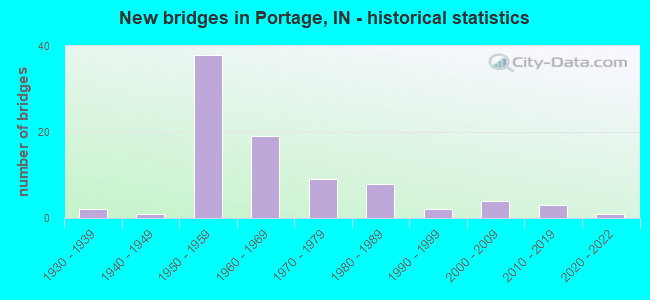
- New bridges - historical statistics
- 21930-1939
- 11940-1949
- 381950-1959
- 191960-1969
- 91970-1979
- 81980-1989
- 21990-1999
- 42000-2009
- 32010-2019
- 12020-2022
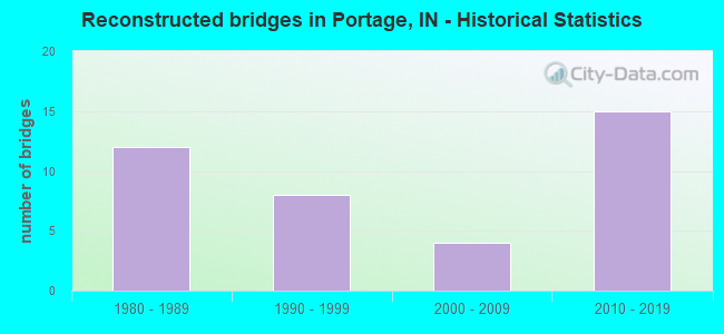
- Reconstructed bridges - Historical Statistics
- 121980-1989
- 81990-1999
- 42000-2009
- 152010-2019
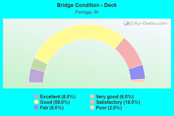
- Bridge Condition - Deck
- 8.0%Excellent
- 6.0%Very good
- 58.0%Good
- 18.0%Satisfactory
- 8.0%Fair
- 2.0%Poor
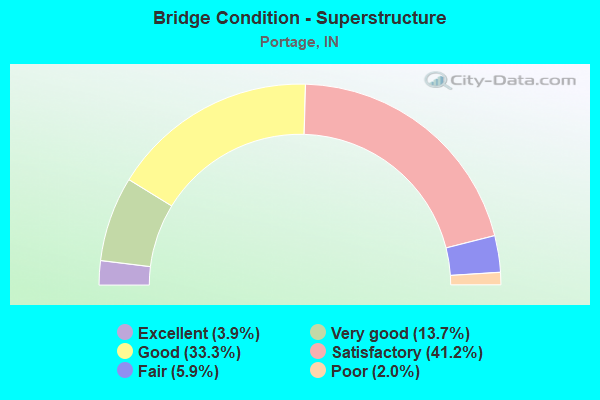
- Bridge Condition - Superstructure
- 3.9%Excellent
- 13.7%Very good
- 33.3%Good
- 41.2%Satisfactory
- 5.9%Fair
- 2.0%Poor
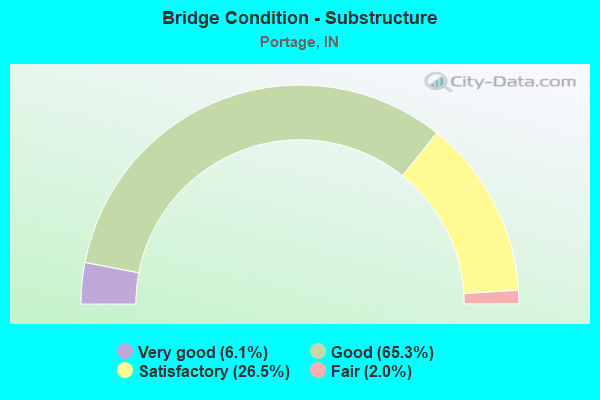
- Bridge Condition - Substructure
- 6.1%Very good
- 65.3%Good
- 26.5%Satisfactory
- 2.0%Fair
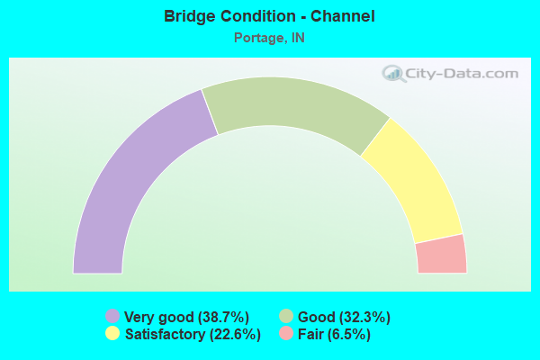
- Bridge Condition - Channel
- 38.7%Very good
- 32.3%Good
- 22.6%Satisfactory
- 6.5%Fair
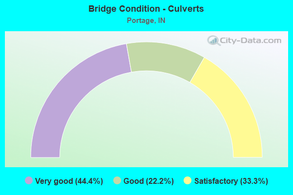
- Bridge Condition - Culverts
- 44.4%Very good
- 22.2%Good
- 33.3%Satisfactory
Find on map >> Show street view
Structure Number: 4905, Location: 00.53 E SR 249 (Lat: 41.601961, Lng: -87.164069), Route carried "on" structure: Interstate 94, Year Built: 1968, Year Reconstructed: 2014, Status: Open, Structure Length: 4.45m (14.60ft), Average Daily Traffic: 35,803 (year 2004), Truck Traffic: 5%, Average Future Daily Traffic: 71,320 (year 2030), Design Load: HS 20+Mod, Features Intersected: JENSEN DR
Minimum Vertical Clearance: 30+ m (98+ ft), Kilometerpoint: 31.028, Lanes on structure: 3, Lanes under structure: 2, Base Highway Network: Yes (, Subroute: 1), Owner: State Highway Agency, Approaching Roadway Width: 19.2m (63.0ft), Material/Design: Steel continuous, Design/Construction: Stringer/Multi-beam, Number Of Spans In Main Unit: 3, Length of Maximum Span: 16.2m (53.1ft), Curb-To-Curb Width: 19.1m (62.7ft), Out-to-Out Width: 19.9m (65.3ft)
Condition: Deck: Good, Superstructure: Good, Substructure: Good, Operating Rating: 71.0 metric tons, Method Used To Determine Operating Rating: Load and Resistance Factor Rating (LRFR) rating reported by rating factor(RF) method using HL-93 loadings, Inventory Rating: 54.4 metric tons, Method Used To Determine Inventory Rating: Load and Resistance Factor Rating (LRFR) rating reported by rating factor(RF) method using HL-93 loadings, Structural Evaluation: Better than present minimum criteria, Deck Geometry: Superior to present desirable criteria, Underclear: Meets minimum limits, Approach Roadway Alignment: Equal to present desirable criteria, Designated Inspection Frequency: Every 24 months, Inspection Date: April 2020, Deck Structure Type: Concrete Cast-file-Place, Wearing Surface/Protective System: Wearing Surface: Monolithic Concrete, Deck Protection: Epoxy Coated Reinforcing
Find on map >> Show street view
Structure Number: 4906, Location: 01.25 W SR 149 (Lat: 41.601761, Lng: -87.147750), Route carried "on" structure: Interstate 94, Year Built: 1969, Year Reconstructed: 1993, Status: Open, Structure Length: 3.93m (12.89ft), Average Daily Traffic: 35,803 (year 2004), Truck Traffic: 5%, Average Future Daily Traffic: 71,320 (year 2030), Design Load: HS 20+Mod, Features Intersected: SALT CREEK
Minimum Vertical Clearance: 30+ m (98+ ft), Kilometerpoint: 32.396, Lanes on structure: 3, Base Highway Network: Yes (, Subroute: 1), Owner: State Highway Agency, Approaching Roadway Width: 19.2m (63.0ft), Material/Design: Prestressed concrete continuous, Design/Construction: Stringer/Multi-beam, Number Of Spans In Main Unit: 3, Length of Maximum Span: 12.2m (40.0ft), Curb-To-Curb Width: 19.1m (62.7ft), Out-to-Out Width: 20.0m (65.6ft)
Condition: Deck: Good, Superstructure: Good, Substructure: Good, Channel: Good, Operating Rating: 40.5 metric tons, Method Used To Determine Operating Rating: Load and Resistance Factor Rating (LRFR) rating reported by rating factor(RF) method using HL-93 loadings, Inventory Rating: 27.9 metric tons, Method Used To Determine Inventory Rating: Load and Resistance Factor Rating (LRFR) rating reported by rating factor(RF) method using HL-93 loadings, Structural Evaluation: Better than present minimum criteria, Deck Geometry: Superior to present desirable criteria, Waterway Adequacy: Superior to present desirable criteria, Approach Roadway Alignment: Equal to present desirable criteria, Designated Inspection Frequency: Every 24 months, Inspection Date: April 2020, Deck Structure Type: Concrete Cast-file-Place, Wearing Surface/Protective System: Wearing Surface: Latex Concrete, Deck Protection: Epoxy Coated Reinforcing
Find on map >> Show street view
Structure Number: 4907, Location: 01.25 W SR 149 (Lat: 41.601931, Lng: -87.147761), Route carried "on" structure: Interstate 94, Year Built: 1969, Year Reconstructed: 1993, Status: Open, Structure Length: 3.93m (12.89ft), Average Daily Traffic: 35,803 (year 2004), Truck Traffic: 5%, Average Future Daily Traffic: 71,320 (year 2030), Design Load: HS 20+Mod, Features Intersected: SALT CREEK
Minimum Vertical Clearance: 30+ m (98+ ft), Kilometerpoint: 32.396, Lanes on structure: 3, Base Highway Network: Yes (, Subroute: 1), Owner: State Highway Agency, Approaching Roadway Width: 19.2m (63.0ft), Material/Design: Prestressed concrete continuous, Design/Construction: Stringer/Multi-beam, Number Of Spans In Main Unit: 3, Length of Maximum Span: 12.2m (40.0ft), Curb-To-Curb Width: 19.1m (62.7ft), Out-to-Out Width: 20.0m (65.6ft)
Condition: Deck: Good, Superstructure: Very good, Substructure: Good, Channel: Good, Operating Rating: 41.1 metric tons, Method Used To Determine Operating Rating: Load and Resistance Factor Rating (LRFR) rating reported by rating factor(RF) method using HL-93 loadings, Inventory Rating: 28.2 metric tons, Method Used To Determine Inventory Rating: Load and Resistance Factor Rating (LRFR) rating reported by rating factor(RF) method using HL-93 loadings, Structural Evaluation: Better than present minimum criteria, Deck Geometry: Superior to present desirable criteria, Waterway Adequacy: Superior to present desirable criteria, Approach Roadway Alignment: Equal to present desirable criteria, Designated Inspection Frequency: Every 24 months, Inspection Date: April 2020, Deck Structure Type: Concrete Cast-file-Place, Wearing Surface/Protective System: Wearing Surface: Latex Concrete, Deck Protection: Epoxy Coated Reinforcing
Find on map >> Show street view
Structure Number: 76602, Location: 01.42 E SR 51 E JCT (Lat: 41.550600, Lng: -87.213311), Route carried "on" structure: US 6, Year Built: 2009, Status: Open, Structure Length: 0.69m (2.26ft), Average Daily Traffic: 24,115 (year 2007), Truck Traffic: 3%, Average Future Daily Traffic: 37,343 (year 2030), Design Load: HS 20, Features Intersected: PEDESTRIAN TUNNEL
Minimum Vertical Clearance: 30+ m (98+ ft), Kilometerpoint: 0.660, Lanes on structure: 5, Base Highway Network: Yes (, Subroute: 1), Owner: State Highway Agency, Approaching Roadway Width: 19.2m (63.0ft), Skew: 25 degrees, Material/Design: Concrete, Design/Construction: Culvert, Number Of Spans In Main Unit: 1, Length of Maximum Span: 6.2m (20.3ft), Curb or Sidewalk Widths: Left: 1.5m (4.9ft), Right: 1.5m (4.9ft), Curb-To-Curb Width: 19.2m (63.0ft), Out-to-Out Width: 27.1m (88.9ft)
Condition: Culverts: Very good, Operating Rating: 78.7 metric tons, Method Used To Determine Operating Rating: Load and Resistance Factor Rating (LRFR) rating reported by rating factor(RF) method using HL-93 loadings, Inventory Rating: 68.4 metric tons, Method Used To Determine Inventory Rating: Load and Resistance Factor Rating (LRFR) rating reported by rating factor(RF) method using HL-93 loadings, Structural Evaluation: Equal to present desirable criteria, Deck Geometry: High priority of replacement, Approach Roadway Alignment: Equal to present desirable criteria, Designated Inspection Frequency: Every 24 months, Inspection Date: November 2020
Find on map >> Show street view
Structure Number: 76604, Location: 02.44 E SR 51 (Lat: 41.550569, Lng: -87.193825), Route carried "on" structure: US 6, Year Built: 2009, Status: Open, Structure Length: 0.67m (2.20ft), Average Daily Traffic: 24,115 (year 2007), Truck Traffic: 3%, Average Future Daily Traffic: 37,343 (year 2032), Design Load: HS 20, Features Intersected: BRANCH OF WILLOWCREEK
Minimum Vertical Clearance: 30+ m (98+ ft), Kilometerpoint: 2.301, Lanes on structure: 4, Base Highway Network: Yes (, Subroute: 1), Owner: State Highway Agency, Approaching Roadway Width: 21.6m (70.9ft), Skew: 30 degrees, Material/Design: Concrete, Design/Construction: Culvert, Number Of Spans In Main Unit: 1, Length of Maximum Span: 6.1m (20.0ft), Curb or Sidewalk Widths: Left: 1.5m (4.9ft), Right: 1.5m (4.9ft), Curb-To-Curb Width: 18.3m (60.0ft), Out-to-Out Width: 33.5m (109.9ft)
Condition: Channel: Satisfactory, Culverts: Very good, Operating Rating: 70.5 metric tons, Method Used To Determine Operating Rating: Load Factor (LF), Inventory Rating: 43.1 metric tons, Method Used To Determine Inventory Rating: Load Factor (LF), Structural Evaluation: Equal to present desirable criteria, Deck Geometry: Meets minimum limits, Waterway Adequacy: Equal to present desirable criteria, Approach Roadway Alignment: Equal to present desirable criteria, Designated Inspection Frequency: Every 24 months, Inspection Date: November 2020
Find on map >> Show street view
Structure Number: 6400082, Location: 00.20 E CR 400 W (Lat: 41.561139, Lng: -87.138664), Route carried "on" structure: City street 62, Year Built: 2001, Status: Open, Structure Length: 2.03m (6.66ft), Average Daily Traffic: 1,170 (year 2018), Truck Traffic: 6%, Average Future Daily Traffic: 2,210 (year 2038), Design Load: HS 20, Features Intersected: SQUIRREL CREEK, Facility Carried by Structure: CR 875N
Minimum Vertical Clearance: 30+ m (98+ ft), Kilometerpoint: 0.000, Lanes on structure: 2, Owner: County Highway Agency, Approaching Roadway Width: 10.1m (33.1ft), Material/Design: Prestressed concrete, Design/Construction: Stringer/Multi-beam, Number Of Spans In Main Unit: 1, Length of Maximum Span: 19.1m (62.7ft), Curb-To-Curb Width: 9.8m (32.2ft), Out-to-Out Width: 10.7m (35.1ft)
Condition: Deck: Very good, Superstructure: Very good, Substructure: Very good, Channel: Very good, Operating Rating: 32.7 metric tons, Method Used To Determine Operating Rating: Field evaluation and documented engineering judgment, Inventory Rating: 32.7 metric tons, Method Used To Determine Inventory Rating: Field evaluation and documented engineering judgment, Structural Evaluation: Equal to present desirable criteria, Deck Geometry: Somewhat better than minimum adequacy, Waterway Adequacy: Equal to present desirable criteria, Approach Roadway Alignment: Equal to present desirable criteria, Designated Inspection Frequency: Every 24 months, Inspection Date: May 2020, Deck Structure Type: Concrete Cast-file-Place, Wearing Surface/Protective System: Wearing Surface: Monolithic Concrete, Deck Protection: Epoxy Coated Reinforcing
Find on map >> Show street view
Structure Number: 6400088, Location: 00.20 W SALT CREEK RD (Lat: 41.596581, Lng: -87.144028), Route carried "on" structure: Alternate City street , Year Built: 1970, Year Reconstructed: 2019, Status: Open, Structure Length: 2.56m (8.40ft), Average Daily Traffic: 2,650 (year 2018), Truck Traffic: 6%, Average Future Daily Traffic: 5,010 (year 2038), Design Load: HL 93, Features Intersected: SALT CREEK, Facility Carried by Structure: OLD PORTER ROAD
Minimum Vertical Clearance: 30+ m (98+ ft), Kilometerpoint: 0.000, Lanes on structure: 2, Owner: County Highway Agency, Approaching Roadway Width: 8.5m (27.9ft), Material/Design: Prestressed concrete continuous, Design/Construction: Tee Beam, Number Of Spans In Main Unit: 1, Length of Maximum Span: 25.1m (82.3ft), Curb-To-Curb Width: 8.3m (27.2ft), Out-to-Out Width: 9.2m (30.2ft)
Condition: Deck: Very good, Superstructure: Excellent, Substructure: Good, Channel: Good, Operating Rating: 70.2 metric tons, Method Used To Determine Operating Rating: Load and Resistance Factor (LRFR), Inventory Rating: 47.7 metric tons, Method Used To Determine Inventory Rating: Load and Resistance Factor (LRFR), Structural Evaluation: Better than present minimum criteria, Deck Geometry: High priority of corrective action, Waterway Adequacy: Equal to present desirable criteria, Approach Roadway Alignment: Equal to present minimum criteria, Designated Inspection Frequency: Every 24 months, Inspection Date: May 2020, Deck Structure Type: Concrete Cast-file-Place, Wearing Surface/Protective System: Wearing Surface: Monolithic Concrete
Find on map >> Show street view
Structure Number: 640011, Location: 00.50 W WILLOWCREEK RD (Lat: 41.564969, Lng: -87.188994), Route carried "on" structure: City street , Year Built: 1966, Year Reconstructed: 2010, Status: Open, Structure Length: 0.91m (2.99ft), Average Daily Traffic: 7,280 (year 2018), Truck Traffic: 6%, Average Future Daily Traffic: 13,760 (year 2038), Design Load: HS 20, Features Intersected: WILLOW CREEK, Facility Carried by Structure: STONE AVENUE
Minimum Vertical Clearance: 30+ m (98+ ft), Kilometerpoint: 0.000, Lanes on structure: 2, Owner: County Highway Agency, Approaching Roadway Width: 8.8m (28.9ft), Material/Design: Steel, Design/Construction: Culvert, Number Of Spans In Main Unit: 2, Length of Maximum Span: 4.3m (14.1ft), Curb-To-Curb Width: 8.8m (28.9ft), Out-to-Out Width: 8.8m (28.9ft)
Condition: Channel: Fair, Culverts: Satisfactory, Inventory Rating: 93.6 metric tons, Method Used To Determine Inventory Rating: Load and Resistance Factor (LRFR), Structural Evaluation: Equal to present minimum criteria, Deck Geometry: High priority of replacement, Waterway Adequacy: Somewhat better than minimum adequacy, Approach Roadway Alignment: Equal to present desirable criteria, Designated Inspection Frequency: Every 24 months, Inspection Date: May 2020
Find on map >> Show street view
Structure Number: 6400111, Location: 00.40 E WILLOWDALE ROAD (Lat: 41.571750, Lng: -87.196678), Route carried "on" structure: Alternate City street , Year Built: 1973, Status: Open, Structure Length: 1.01m (3.31ft), Average Daily Traffic: 3,010 (year 2018), Truck Traffic: 6%, Average Future Daily Traffic: 5,690 (year 2038), Design Load: HS 20, Features Intersected: WILLOW CREEK, Facility Carried by Structure: MULBERRY AVENUE
Minimum Vertical Clearance: 30+ m (98+ ft), Kilometerpoint: 0.000, Lanes on structure: 2, Owner: County Highway Agency, Approaching Roadway Width: 8.2m (26.9ft), Material/Design: Prestressed concrete, Design/Construction: Box Beam or Girders - Multiple, Number Of Spans In Main Unit: 1, Length of Maximum Span: 8.8m (28.9ft), Curb or Sidewalk Widths: Left: 0.0m, Right: 1.0m (3.3ft), Curb-To-Curb Width: 8.4m (27.6ft), Out-to-Out Width: 10.0m (32.8ft)
Condition: Deck: Fair, Superstructure: Fair, Substructure: Satisfactory, Channel: Satisfactory, Operating Rating: 51.6 metric tons, Method Used To Determine Operating Rating: Load Factor (LF), Inventory Rating: 30.9 metric tons, Method Used To Determine Inventory Rating: Load Factor (LF), Structural Evaluation: Somewhat better than minimum adequacy, Deck Geometry: High priority of corrective action, Waterway Adequacy: Equal to present desirable criteria, Approach Roadway Alignment: Equal to present desirable criteria, Length Of Structure Improvement: 1.01m (3.31ft), Designated Inspection Frequency: Every 24 months, Inspection Date: May 2020, Bridge Improvement Cost: $247,000, Roadway Improvement Cost: $82,000, Total Project Cost: $395,000 ( Estimate for 2020), Deck Structure Type: Concrete Precast Panels, Wearing Surface/Protective System: Wearing Surface: Bituminous
Find on map >> Show street view
Structure Number: 6400113, Location: 00.20 SW SWANSON RD (Lat: 41.575969, Lng: -87.199561), Route carried "on" structure: City street , Year Built: 1973, Status: Open, Structure Length: 1.43m (4.69ft), Average Daily Traffic: 8,390 (year 2018), Truck Traffic: 6%, Average Future Daily Traffic: 15,860 (year 2038), Design Load: HS 20, Features Intersected: WILLOW CREEK, Facility Carried by Structure: CENTRAL AVENUE
Minimum Vertical Clearance: 30+ m (98+ ft), Kilometerpoint: 0.000, Lanes on structure: 2, Owner: County Highway Agency, Approaching Roadway Width: 8.5m (27.9ft), Skew: 4 degrees, Material/Design: Prestressed concrete, Design/Construction: Box Beam or Girders - Multiple, Number Of Spans In Main Unit: 1, Length of Maximum Span: 13.1m (43.0ft), Curb or Sidewalk Widths: Left: 1.2m (3.9ft), Right: 0.0m, Curb-To-Curb Width: 7.3m (24.0ft), Out-to-Out Width: 8.7m (28.5ft)
Condition: Deck: Fair, Superstructure: Fair, Substructure: Satisfactory, Channel: Fair, Operating Rating: 44.5 metric tons, Method Used To Determine Operating Rating: Load and Resistance Factor (LRFR), Inventory Rating: 42.0 metric tons, Method Used To Determine Inventory Rating: Load and Resistance Factor (LRFR), Structural Evaluation: Somewhat better than minimum adequacy, Deck Geometry: High priority of replacement, Waterway Adequacy: Equal to present minimum criteria, Approach Roadway Alignment: High priority of corrective action, Designated Inspection Frequency: Every 24 months, Inspection Date: May 2020, Deck Structure Type: Concrete Precast Panels, Wearing Surface/Protective System: Wearing Surface: Bituminous
Find on map >> Show street view
Structure Number: 6400114, Location: 00.50 E DOMBEY RD (Lat: 41.588289, Lng: -87.204492), Route carried "on" structure: Alternate City street , Year Built: 1973, Year Reconstructed: 2018, Status: Open, Structure Length: 1.13m (3.71ft), Average Daily Traffic: 740 (year 2018), Truck Traffic: 6%, Average Future Daily Traffic: 1,400 (year 2038), Design Load: HS 20, Features Intersected: WILLOW CREEK, Facility Carried by Structure: CLEM ROAD
Minimum Vertical Clearance: 30+ m (98+ ft), Kilometerpoint: 0.000, Lanes on structure: 2, Owner: County Highway Agency, Approaching Roadway Width: 6.7m (22.0ft), Skew: 1 degrees, Material/Design: Prestressed concrete, Design/Construction: Box Beam or Girders - Multiple, Number Of Spans In Main Unit: 1, Length of Maximum Span: 9.9m (32.5ft), Curb or Sidewalk Widths: Left: 0.0m, Right: 1.1m (3.6ft), Curb-To-Curb Width: 8.8m (28.9ft), Out-to-Out Width: 9.9m (32.5ft)
Condition: Deck: Very good, Superstructure: Very good, Substructure: Good, Channel: Good, Operating Rating: 56.6 metric tons, Method Used To Determine Operating Rating: Load and Resistance Factor (LRFR), Inventory Rating: 43.0 metric tons, Method Used To Determine Inventory Rating: Load and Resistance Factor (LRFR), Structural Evaluation: Better than present minimum criteria, Deck Geometry: Somewhat better than minimum adequacy, Waterway Adequacy: Better than present minimum criteria, Approach Roadway Alignment: Equal to present desirable criteria, Designated Inspection Frequency: Every 24 months, Inspection Date: May 2020, Deck Structure Type: Concrete Precast Panels, Wearing Surface/Protective System: Wearing Surface: Bituminous
Find on map >> Show street view
Structure Number: 6400115, Location: 00.30 E MCCOOL RD (Lat: 41.583500, Lng: -87.137500), Route carried "on" structure: City street , Year Built: 1968, Status: Open, Structure Length: 3.26m (10.70ft), Average Daily Traffic: 3,140 (year 2018), Truck Traffic: 6%, Average Future Daily Traffic: 5,930 (year 2038), Design Load: HS 20, Features Intersected: SALT CREEK, Facility Carried by Structure: LENBURG ROAD
Minimum Vertical Clearance: 30+ m (98+ ft), Kilometerpoint: 0.000, Lanes on structure: 2, Owner: County Highway Agency, Approaching Roadway Width: 7.0m (23.0ft), Material/Design: Prestressed concrete, Design/Construction: Box Beam or Girders - Multiple, Number Of Spans In Main Unit: 3, Length of Maximum Span: 15.2m (49.9ft), Curb or Sidewalk Widths: Left: 0.3m (1.0ft), Right: 0.3m (1.0ft), Curb-To-Curb Width: 9.3m (30.5ft), Out-to-Out Width: 9.8m (32.2ft)
Condition: Deck: Poor, Superstructure: Poor, Substructure: Fair, Channel: Satisfactory, Operating Rating: 47.7 metric tons, Method Used To Determine Operating Rating: Load Factor (LF), Inventory Rating: 28.6 metric tons, Method Used To Determine Inventory Rating: Load Factor (LF), Structural Evaluation: Meets minimum limits, Deck Geometry: Meets minimum limits, Waterway Adequacy: Equal to present desirable criteria, Approach Roadway Alignment: Equal to present minimum criteria, Length Of Structure Improvement: 3.66m (12.01ft), Designated Inspection Frequency: Every 12 months, Inspection Date: May 2021, Bridge Improvement Cost: $1,727,000, Roadway Improvement Cost: $287,000, Total Project Cost: $2,416,000 ( Estimate for 2021), Deck Structure Type: Concrete Precast Panels, Wearing Surface/Protective System: Wearing Surface: Bituminous
Find on map >> Show street view
Structure Number: 6400131, Location: 00.10 E WILLOWCREEK ROAD (Lat: 41.586689, Lng: -87.182328), Route carried "on" structure: City street , Year Built: 1987, Status: Open, Structure Length: 1.34m (4.40ft), Average Daily Traffic: 1,910 (year 2018), Truck Traffic: 6%, Average Future Daily Traffic: 3,610 (year 2038), Features Intersected: PORTAGE AVENUE, Facility Carried by Structure: CRISMAN ROAD
Minimum Vertical Clearance: 30+ m (98+ ft), Kilometerpoint: 0.000, Lanes on structure: 4, Lanes under structure: 2, Owner: County Highway Agency, Approaching Roadway Width: 15.5m (50.9ft), Skew: 4 degrees, Material/Design: Steel, Design/Construction: Culvert, Number Of Spans In Main Unit: 1, Length of Maximum Span: 9.7m (31.8ft), Curb or Sidewalk Widths: Left: 1.7m (5.6ft), Right: 1.7m (5.6ft), Curb-To-Curb Width: 12.1m (39.7ft), Out-to-Out Width: 15.5m (50.9ft)
Condition: Culverts: Good, Operating Rating: 32.7 metric tons, Method Used To Determine Operating Rating: Field evaluation and documented engineering judgment, Inventory Rating: 32.7 metric tons, Method Used To Determine Inventory Rating: Field evaluation and documented engineering judgment, Structural Evaluation: Better than present minimum criteria, Deck Geometry: High priority of replacement, Underclear: High priority of corrective action, Approach Roadway Alignment: Equal to present minimum criteria, Designated Inspection Frequency: Every 24 months, Inspection Date: May 2020
Find on map >> Show street view
Structure Number: 6400132, Location: 00.10 NE PORTAGE AVENUE (Lat: 41.587281, Lng: -87.181375), Route carried "on" structure: City street , Year Built: 1987, Status: Open, Structure Length: 4.82m (15.81ft), Average Daily Traffic: 1,910 (year 2018), Truck Traffic: 6%, Average Future Daily Traffic: 3,610 (year 2038), Design Load: HS 20, Features Intersected: CSX RAILROAD, Facility Carried by Structure: CRISMAN ROAD
Minimum Vertical Clearance: 30+ m (98+ ft), Kilometerpoint: 0.000, Lanes on structure: 4, Owner: County Highway Agency, Approaching Roadway Width: 15.5m (50.9ft), Skew: 2 degrees, Material/Design: Steel continuous, Design/Construction: Stringer/Multi-beam, Number Of Spans In Main Unit: 3, Length of Maximum Span: 18.3m (60.0ft), Curb or Sidewalk Widths: Left: 1.5m (4.9ft), Right: 1.5m (4.9ft), Curb-To-Curb Width: 15.5m (50.9ft), Out-to-Out Width: 19.2m (63.0ft)
Condition: Deck: Good, Superstructure: Good, Substructure: Good, Operating Rating: 32.7 metric tons, Method Used To Determine Operating Rating: Field evaluation and documented engineering judgment, Inventory Rating: 32.7 metric tons, Method Used To Determine Inventory Rating: Field evaluation and documented engineering judgment, Structural Evaluation: Better than present minimum criteria, Deck Geometry: Meets minimum limits, Underclear: Meets minimum limits, Approach Roadway Alignment: Equal to present minimum criteria, Length Of Structure Improvement: 1.52m (4.99ft), Designated Inspection Frequency: Every 24 months, Inspection Date: May 2020, Bridge Improvement Cost: $52,000, Roadway Improvement Cost: $21,000, Total Project Cost: $87,000 ( Estimate for 2020), Deck Structure Type: Concrete Cast-file-Place, Wearing Surface/Protective System: Wearing Surface: Monolithic Concrete
Find on map >> Show street view
Structure Number: 6400133, Location: 00.40 SW OLD PORTER ROAD (Lat: 41.589681, Lng: -87.175583), Route carried "on" structure: City street , Year Built: 1987, Status: Open, Structure Length: 6.40m (21.00ft), Average Daily Traffic: 1,910 (year 2018), Truck Traffic: 6%, Average Future Daily Traffic: 3,610 (year 2038), Design Load: HS 20, Features Intersected: CONRAIL RAILROAD, Facility Carried by Structure: CRISMAN ROAD
Minimum Vertical Clearance: 30+ m (98+ ft), Kilometerpoint: 0.000, Lanes on structure: 4, Owner: County Highway Agency, Approaching Roadway Width: 15.5m (50.9ft), Skew: 4 degrees, Material/Design: Steel continuous, Design/Construction: Stringer/Multi-beam, Number Of Spans In Main Unit: 3, Length of Maximum Span: 24.4m (80.1ft), Curb or Sidewalk Widths: Left: 1.5m (4.9ft), Right: 1.5m (4.9ft), Curb-To-Curb Width: 15.5m (50.9ft), Out-to-Out Width: 19.2m (63.0ft)
Condition: Deck: Good, Superstructure: Good, Substructure: Satisfactory, Operating Rating: 32.7 metric tons, Method Used To Determine Operating Rating: Field evaluation and documented engineering judgment, Inventory Rating: 32.7 metric tons, Method Used To Determine Inventory Rating: Field evaluation and documented engineering judgment, Structural Evaluation: Equal to present minimum criteria, Deck Geometry: Meets minimum limits, Underclear: Better than present minimum criteria, Approach Roadway Alignment: Equal to present minimum criteria, Length Of Structure Improvement: 1.52m (4.99ft), Designated Inspection Frequency: Every 24 months, Inspection Date: May 2020, Bridge Improvement Cost: $52,000, Roadway Improvement Cost: $21,000, Total Project Cost: $87,000 ( Estimate for 2020), Deck Structure Type: Concrete Cast-file-Place, Wearing Surface/Protective System: Wearing Surface: Monolithic Concrete
Find on map >> Show street view
Structure Number: 640015, Location: 00.20 W CR 600W (Lat: 41.375689, Lng: -87.185464), Route carried "on" structure: County highway , Year Built: 2001, Status: Open, Structure Length: 0.74m (2.43ft), Average Daily Traffic: 300 (year 2018), Truck Traffic: 2%, Average Future Daily Traffic: 570 (year 2038), Design Load: HS 20, Features Intersected: CORNELL DITCH, Facility Carried by Structure: OLD FAITHFUL DRIVE
Minimum Vertical Clearance: 30+ m (98+ ft), Kilometerpoint: 0.000, Lanes on structure: 2, Owner: County Highway Agency, Approaching Roadway Width: 9.1m (29.9ft), Skew: 1 degrees, Material/Design: Concrete, Design/Construction: Culvert, Number Of Spans In Main Unit: 2, Length of Maximum Span: 3.0m (9.8ft), Curb or Sidewalk Widths: Left: 1.6m (5.2ft), Right: 1.6m (5.2ft), Curb-To-Curb Width: 8.0m (26.2ft), Out-to-Out Width: 11.3m (37.1ft)
Condition: Channel: Good, Culverts: Good, Operating Rating: 32.7 metric tons, Method Used To Determine Operating Rating: Field evaluation and documented engineering judgment, Inventory Rating: 32.7 metric tons, Method Used To Determine Inventory Rating: Field evaluation and documented engineering judgment, Structural Evaluation: Better than present minimum criteria, Deck Geometry: Somewhat better than minimum adequacy, Waterway Adequacy: Equal to present minimum criteria, Approach Roadway Alignment: Equal to present minimum criteria, Designated Inspection Frequency: Every 24 months, Inspection Date: May 2020
Find on map >> Show street view
Structure Number: 6400156, Location: 00.20 E SWANSON ROAD (Lat: 41.557800, Lng: -87.194114), Route carried "on" structure: Alternate City street , Year Built: 2011, Status: Open, Structure Length: 1.63m (5.35ft), Average Daily Traffic: 920 (year 2018), Truck Traffic: 6%, Average Future Daily Traffic: 1,740 (year 2038), Design Load: HL 93, Features Intersected: WILLOW CREEK, Facility Carried by Structure: LUTE ROAD
Minimum Vertical Clearance: 30+ m (98+ ft), Kilometerpoint: 0.000, Lanes on structure: 2, Owner: County Highway Agency, Approaching Roadway Width: 8.8m (28.9ft), Skew: 2 degrees, Material/Design: Prestressed concrete, Design/Construction: Stringer/Multi-beam, Number Of Spans In Main Unit: 1, Length of Maximum Span: 14.9m (48.9ft), Curb or Sidewalk Widths: Left: 2.0m (6.6ft), Right: 2.0m (6.6ft), Curb-To-Curb Width: 8.5m (27.9ft), Out-to-Out Width: 13.3m (43.6ft)
Condition: Deck: Good, Superstructure: Very good, Substructure: Good, Channel: Very good, Operating Rating: 32.7 metric tons, Method Used To Determine Operating Rating: Field evaluation and documented engineering judgment, Inventory Rating: 32.7 metric tons, Method Used To Determine Inventory Rating: Field evaluation and documented engineering judgment, Structural Evaluation: Better than present minimum criteria, Deck Geometry: Somewhat better than minimum adequacy, Waterway Adequacy: Equal to present desirable criteria, Approach Roadway Alignment: Equal to present desirable criteria, Designated Inspection Frequency: Every 24 months, Inspection Date: May 2020, Deck Structure Type: Concrete Cast-file-Place, Wearing Surface/Protective System: Wearing Surface: Monolithic Concrete, Deck Protection: Epoxy Coated Reinforcing
Find on map >> Show street view
Structure Number: 6400157, Location: 00.10 W BLACKSTONE CIRCLE (Lat: 41.578500, Lng: -87.158419), Route carried "on" structure: City street , Year Built: 2012, Status: Open, Structure Length: 1.55m (5.09ft), Average Daily Traffic: 500 (year 2018), Truck Traffic: 3%, Average Future Daily Traffic: 950 (year 2038), Design Load: HS 25 or greater, Features Intersected: ROBBINS DITCH, Facility Carried by Structure: JOSEPH AVENUE
Minimum Vertical Clearance: 30+ m (98+ ft), Kilometerpoint: 0.000, Lanes on structure: 2, Owner: County Highway Agency, Approaching Roadway Width: 7.3m (24.0ft), Material/Design: Concrete, Design/Construction: Culvert, Number Of Spans In Main Unit: 1, Length of Maximum Span: 14.6m (47.9ft), Curb or Sidewalk Widths: Left: 0.6m (2.0ft), Right: 2.3m (7.5ft), Curb-To-Curb Width: 7.6m (24.9ft), Out-to-Out Width: 11.0m (36.1ft)
Condition: Channel: Very good, Culverts: Very good, Operating Rating: 32.7 metric tons, Method Used To Determine Operating Rating: Field evaluation and documented engineering judgment, Inventory Rating: 32.7 metric tons, Method Used To Determine Inventory Rating: Field evaluation and documented engineering judgment, Structural Evaluation: Equal to present desirable criteria, Deck Geometry: Meets minimum limits, Waterway Adequacy: Equal to present desirable criteria, Approach Roadway Alignment: Equal to present desirable criteria, Designated Inspection Frequency: Every 24 months, Inspection Date: May 2020
Find on map >> Show street view
Structure Number: 6400163, Location: 00.20 E DOMBEY ROAD (Lat: 41.579581, Lng: -87.207297), Route carried "on" structure: Alternate City street , Year Built: 2014, Status: Open, Structure Length: 1.75m (5.74ft), Average Daily Traffic: 1,970 (year 2018), Truck Traffic: 5%, Average Future Daily Traffic: 3,720 (year 2038), Features Intersected: WILLOW CREEK, Facility Carried by Structure: EVERGREENS STREET
Minimum Vertical Clearance: 30+ m (98+ ft), Kilometerpoint: 0.000, Lanes on structure: 2, Owner: County Highway Agency, Approaching Roadway Width: 7.3m (24.0ft), Skew: 2 degrees, Material/Design: Steel, Design/Construction: Stringer/Multi-beam, Number Of Spans In Main Unit: 1, Length of Maximum Span: 15.4m (50.5ft), Curb-To-Curb Width: 9.1m (29.9ft), Out-to-Out Width: 9.1m (29.9ft)
Condition: Deck: Good, Superstructure: Satisfactory, Substructure: Good, Channel: Good, Operating Rating: 32.7 metric tons, Method Used To Determine Operating Rating: Field evaluation and documented engineering judgment, Inventory Rating: 32.7 metric tons, Method Used To Determine Inventory Rating: Field evaluation and documented engineering judgment, Structural Evaluation: Equal to present minimum criteria, Deck Geometry: Somewhat better than minimum adequacy, Waterway Adequacy: Equal to present desirable criteria, Approach Roadway Alignment: Equal to present desirable criteria, Designated Inspection Frequency: Every 24 months, Inspection Date: May 2020, Deck Structure Type: Concrete Cast-file-Place, Wearing Surface/Protective System: Wearing Surface: Monolithic Concrete, Deck Protection: Epoxy Coated Reinforcing
Find on map >> Show street view
Structure Number: 640018, Location: 00.36 S CR 700 N (Lat: 41.530600, Lng: -87.143461), Route carried "on" structure: Alternate City street 56, Year Built: 1961, Status: Open, Structure Length: 0.64m (2.10ft), Average Daily Traffic: 190 (year 2018), Truck Traffic: 6%, Average Future Daily Traffic: 360 (year 2038), Design Load: HS 20, Features Intersected: UNT SALT CREEK, Facility Carried by Structure: CR 400W/MCCOOL RD.
Minimum Vertical Clearance: 30+ m (98+ ft), Kilometerpoint: 0.000, Lanes on structure: 2, Owner: County Highway Agency, Approaching Roadway Width: 7.6m (24.9ft), Skew: 3 degrees, Material/Design: Concrete continuous, Design/Construction: Culvert, Number Of Spans In Main Unit: 2, Length of Maximum Span: 3.0m (9.8ft)
Condition: Channel: Satisfactory, Culverts: Satisfactory, Operating Rating: 40.8 metric tons, Method Used To Determine Operating Rating: Field evaluation and documented engineering judgment, Inventory Rating: 32.7 metric tons, Method Used To Determine Inventory Rating: Field evaluation and documented engineering judgment, Structural Evaluation: Equal to present minimum criteria, Waterway Adequacy: Equal to present minimum criteria, Approach Roadway Alignment: Equal to present desirable criteria, Designated Inspection Frequency: Every 24 months, Inspection Date: May 2020
Find on map >> Show street view
Structure Number: 6400182, Location: 00.42 E, HAMSTROM ROAD (Lat: 41.575939, Lng: -87.160389), Route carried "on" structure: City street , Year Built: 2020, Status: Open, Structure Length: 0.80m (2.62ft), Average Daily Traffic: 11,200 (year 2017), Truck Traffic: 5%, Average Future Daily Traffic: 20,600 (year 2037), Design Load: HS 20, Features Intersected: ROBBINS DITCH, Facility Carried by Structure: CENTRAL AVENUE
Minimum Vertical Clearance: 30+ m (98+ ft), Kilometerpoint: 0.000, Lanes on structure: 2, Owner: County Highway Agency, Approaching Roadway Width: 8.8m (28.9ft), Skew: 3 degrees, Material/Design: Concrete, Design/Construction: Culvert, Number Of Spans In Main Unit: 1, Length of Maximum Span: 7.3m (24.0ft), Curb or Sidewalk Widths: Left: 0.0m, Right: 1.5m (4.9ft), Curb-To-Curb Width: 8.8m (28.9ft), Out-to-Out Width: 15.2m (49.9ft)
Condition: Channel: Satisfactory, Culverts: Very good, Operating Rating: 40.8 metric tons, Method Used To Determine Operating Rating: Field evaluation and documented engineering judgment, Inventory Rating: 32.7 metric tons, Method Used To Determine Inventory Rating: Field evaluation and documented engineering judgment, Structural Evaluation: Equal to present desirable criteria, Deck Geometry: High priority of replacement, Waterway Adequacy: Equal to present minimum criteria, Approach Roadway Alignment: Equal to present desirable criteria, Designated Inspection Frequency: Every 24 months, Inspection Date: May 2020, Wearing Surface/Protective System: Wearing Surface: Bituminous, Membrane: Built-up
Find on map >> Show street view
Structure Number: 3041, Location: 00.24 N US-20 (Lat: 41.602011, Lng: -87.173828), Route carried "under" structure: Interstate 94, Year Built: 1967, Structure Length: 0. m, Average Daily Traffic: 31,192 (year 2020), Truck Traffic: 34%, Features Intersected: I-94 EBL, Facility Carried by Structure: SR 249 NB
Minimum Vertical Clearance: 5.13m (16.83ft), Kilometerpoint: 30.175, Lanes on structure: 3, Lanes under structure: 8, Material/Design: Steel continuous, Design/Construction: Stringer/Multi-beam, Length of Maximum Span: 25.0m (82.0ft)
Find on map >> Show street view
Structure Number: 3041, Location: 00.24 N US-20 (Lat: 41.602011, Lng: -87.173828), Route carried "under" structure: Interstate 94, Year Built: 1967, Structure Length: 0. m, Average Daily Traffic: 31,043 (year 2020), Truck Traffic: 34%, Features Intersected: I-94 WBL, Facility Carried by Structure: SR 249 NB
Minimum Vertical Clearance: 5.13m (16.83ft), Kilometerpoint: 30.175, Lanes on structure: 3, Lanes under structure: 8, Material/Design: Steel continuous, Design/Construction: Stringer/Multi-beam, Length of Maximum Span: 25.0m (82.0ft)
Find on map >> Show street view
Structure Number: 3042, Location: 00.24 N US-20 (Lat: 41.602011, Lng: -87.174133), Route carried "under" structure: Interstate 94, Year Built: 1967, Structure Length: 0. m, Average Daily Traffic: 41,990 (year 2004), Truck Traffic: 15%, Features Intersected: I-94 WBL, Facility Carried by Structure: SR 249 SB
Minimum Vertical Clearance: 5.23m (17.16ft), Kilometerpoint: 30.175, Lanes on structure: 3, Lanes under structure: 8, Material/Design: Steel continuous, Design/Construction: Stringer/Multi-beam, Length of Maximum Span: 25.0m (82.0ft)
Find on map >> Show street view
Structure Number: 3042, Location: 00.24 N US-20 (Lat: 41.602011, Lng: -87.174133), Route carried "under" structure: Interstate 94, Year Built: 1967, Structure Length: 0. m, Average Daily Traffic: 41,990 (year 2004), Truck Traffic: 15%, Features Intersected: I-94 EBL, Facility Carried by Structure: SR 249 SB
Minimum Vertical Clearance: 5.23m (17.16ft), Kilometerpoint: 30.175, Lanes on structure: 3, Lanes under structure: 8, Material/Design: Steel continuous, Design/Construction: Stringer/Multi-beam, Length of Maximum Span: 25.0m (82.0ft)
Find on map >> Show street view
Structure Number: 4673, Location: 00.63 E I-94 (Lat: 41.586819, Lng: -87.212394), Route carried "under" structure: Interstate 90, Year Built: 1956, Structure Length: 0. m, Average Daily Traffic: 17,335 (year 2014), Truck Traffic: 24%, Features Intersected: I-90 EB, Facility Carried by Structure: DOMBEY RD
Minimum Vertical Clearance: 5.21m (17.09ft), Kilometerpoint: 35.293, Lanes on structure: 2, Lanes under structure: 2, Toll: On toll road, Material/Design: Steel, Design/Construction: Stringer/Multi-beam, Length of Maximum Span: 24.4m (80.1ft)
Find on map >> Show street view
Structure Number: 4673, Location: 00.63 E I-94 (Lat: 41.586819, Lng: -87.212394), Route carried "under" structure: Interstate 90, Year Built: 1956, Structure Length: 0. m, Average Daily Traffic: 17,335 (year 2014), Truck Traffic: 24%, Features Intersected: I-90 WB, Facility Carried by Structure: DOMBEY RD
Minimum Vertical Clearance: 5.11m (16.77ft), Kilometerpoint: 35.293, Lanes on structure: 2, Lanes under structure: 2, Toll: On toll road, Material/Design: Steel, Design/Construction: Stringer/Multi-beam, Length of Maximum Span: 24.4m (80.1ft)
Find on map >> Show street view
Structure Number: 4676, Location: 01.50 E I-94 (Lat: 41.581789, Lng: -87.197739), Route carried "under" structure: County highway , Year Built: 1956, Structure Length: 0. m, Average Daily Traffic: 3,751 (year 2014), Truck Traffic: 4%, Features Intersected: CRUIKSHANK ROAD, Facility Carried by Structure: I-90 EB
Minimum Vertical Clearance: 4.52m (14.83ft), Kilometerpoint: 0.000, Lanes on structure: 2, Lanes under structure: 2, Material/Design: Steel, Design/Construction: Stringer/Multi-beam, Length of Maximum Span: 10.4m (34.1ft)
Find on map >> Show street view
Structure Number: 4677, Location: 01.50 E I-94 (Lat: 41.582039, Lng: -87.197739), Route carried "under" structure: County highway , Year Built: 1956, Structure Length: 0. m, Average Daily Traffic: 3,751 (year 2014), Truck Traffic: 4%, Features Intersected: CRUIKSHANK RD, Facility Carried by Structure: I-90 WB
Minimum Vertical Clearance: 4.50m (14.76ft), Kilometerpoint: 0.000, Lanes on structure: 2, Lanes under structure: 2, Toll: On toll road, Material/Design: Steel, Design/Construction: Stringer/Multi-beam, Length of Maximum Span: 10.4m (34.1ft)
Find on map >> Show street view
Structure Number: 4678, Location: 02.26 E I-94 (Lat: 41.580261, Lng: -87.183158), Route carried "under" structure: Interstate 90, Year Built: 1956, Structure Length: 0. m, Average Daily Traffic: 17,275 (year 2014), Truck Traffic: 24%, Features Intersected: I-90 EB, Facility Carried by Structure: CR 600W /WILLOWCRK
Minimum Vertical Clearance: 5.01m (16.44ft), Kilometerpoint: 37.916, Lanes on structure: 4, Lanes under structure: 2, Toll: On toll road, Material/Design: Steel, Design/Construction: Stringer/Multi-beam, Length of Maximum Span: 23.5m (77.1ft)
Find on map >> Show street view
Structure Number: 4678, Location: 02.26 E I-94 (Lat: 41.580261, Lng: -87.183150), Route carried "under" structure: Interstate 90, Year Built: 1956, Structure Length: 0. m, Average Daily Traffic: 17,275 (year 2014), Truck Traffic: 24%, Features Intersected: i-90 WB, Facility Carried by Structure: CR 600W/WILLOWCRK
Minimum Vertical Clearance: 5.01m (16.44ft), Kilometerpoint: 37.916, Lanes on structure: 4, Lanes under structure: 2, Toll: On toll road, Material/Design: Steel, Design/Construction: Stringer/Multi-beam, Length of Maximum Span: 23.5m (77.1ft)
Find on map >> Show street view
Structure Number: 46785, Location: 02.45 E I-94 (Lat: 41.580181, Lng: -87.179428), Route carried "under" structure: Interstate 90, Year Built: 1984, Structure Length: 0. m, Average Daily Traffic: 32,455 (year 2014), Truck Traffic: 14%, Features Intersected: I-90 WBL
Minimum Vertical Clearance: 4.95m (16.24ft), Kilometerpoint: 38.222, Lanes on structure: 2, Lanes under structure: 4, Toll: On toll road, Material/Design: Steel continuous, Design/Construction: Stringer/Multi-beam, Length of Maximum Span: 47.5m (155.8ft)
Find on map >> Show street view
Structure Number: 46785, Location: 02.45 E I-94 (Lat: 41.580181, Lng: -87.179428), Route carried "under" structure: Interstate 90, Year Built: 1984, Structure Length: 0. m, Average Daily Traffic: 32,455 (year 2014), Truck Traffic: 24%, Features Intersected: I-90 EBL
Minimum Vertical Clearance: 4.95m (16.24ft), Kilometerpoint: 38.222, Lanes on structure: 2, Lanes under structure: 4, Toll: On toll road, Material/Design: Steel continuous, Design/Construction: Stringer/Multi-beam, Length of Maximum Span: 47.5m (155.8ft)
Find on map >> Show street view
Structure Number: 4679, Location: 02.50 W SR 149 (Lat: 41.579939, Lng: -87.168572), Route carried "under" structure: County highway 525, Year Built: 1956, Structure Length: 0. m, Average Daily Traffic: 6,255 (year 2014), Truck Traffic: 3%, Features Intersected: HAMSTROM RD/CR 525W, Facility Carried by Structure: I-90 EB
Minimum Vertical Clearance: 4.19m (13.75ft), Kilometerpoint: 0.000, Lanes on structure: 2, Lanes under structure: 2, Material/Design: Steel, Design/Construction: Stringer/Multi-beam, Length of Maximum Span: 10.1m (33.1ft)
Find on map >> Show street view
Structure Number: 468, Location: 02.50 W SR 149 (Lat: 41.580111, Lng: -87.168586), Route carried "under" structure: County highway , Year Built: 1956, Structure Length: 0. m, Average Daily Traffic: 6,255 (year 2014), Truck Traffic: 3%, Features Intersected: HAMSTROM RD, Facility Carried by Structure: I-90 WB
Minimum Vertical Clearance: 4.12m (13.52ft), Kilometerpoint: 0.000, Lanes on structure: 2, Lanes under structure: 2, Toll: On toll road, Material/Design: Steel, Design/Construction: Stringer/Multi-beam, Length of Maximum Span: 10.1m (33.1ft)
Find on map >> Show street view
Structure Number: 4681, Location: 01.78 W SR 149 (Lat: 41.575889, Lng: -87.156592), Route carried "under" structure: County highway 975, Year Built: 1956, Structure Length: 0. m, Average Daily Traffic: 11,075 (year 2014), Truck Traffic: 5%, Features Intersected: CENTRAL AVE/CR 975N, Facility Carried by Structure: I-90 EB
Minimum Vertical Clearance: 7.26m (23.82ft), Kilometerpoint: 0.000, Lanes on structure: 2, Lanes under structure: 2, Material/Design: Steel, Design/Construction: Stringer/Multi-beam, Length of Maximum Span: 14.9m (48.9ft)
Find on map >> Show street view
Structure Number: 4682, Location: 01.78 W SR 149 (Lat: 41.575900, Lng: -87.156211), Route carried "under" structure: County highway 75, Year Built: 1956, Structure Length: 0. m, Average Daily Traffic: 11,075 (year 2014), Truck Traffic: 5%, Features Intersected: CENTRAL AVE/CR 975N, Facility Carried by Structure: I-90 WB
Minimum Vertical Clearance: 7.34m (24.08ft), Kilometerpoint: 0.000, Lanes on structure: 2, Lanes under structure: 2, Material/Design: Steel, Design/Construction: Stringer/Multi-beam, Length of Maximum Span: 14.9m (48.9ft)
Find on map >> Show street view
Structure Number: 4685, Location: 01.56 W SR 149 (Lat: 41.573469, Lng: -87.153397), Route carried "under" structure: County highway 450, Year Built: 1956, Structure Length: 0. m, Average Daily Traffic: 5,400 (year 2014), Truck Traffic: 5%, Features Intersected: SAMUELSON RD/CR 450W, Facility Carried by Structure: I-90 EB
Minimum Vertical Clearance: 4.78m (15.68ft), Kilometerpoint: 0.000, Lanes on structure: 2, Lanes under structure: 2, Material/Design: Steel, Design/Construction: Stringer/Multi-beam, Length of Maximum Span: 19.5m (64.0ft)
Find on map >> Show street view
Structure Number: 4686, Location: 01.56 W SR 149 (Lat: 41.573739, Lng: -87.153397), Route carried "under" structure: County highway 450, Year Built: 1956, Structure Length: 0. m, Average Daily Traffic: 5,400 (year 2014), Truck Traffic: 5%, Features Intersected: SAMUELSON RD/CR 450W, Facility Carried by Structure: I-90 WB
Minimum Vertical Clearance: 4.83m (15.85ft), Kilometerpoint: 0.000, Lanes on structure: 2, Lanes under structure: 2, Material/Design: Steel, Design/Construction: Stringer/Multi-beam, Length of Maximum Span: 19.5m (64.0ft)
Find on map >> Show street view
Structure Number: 4687, Location: 01.04 W SR 149 (Lat: 41.571950, Lng: -87.143731), Route carried "under" structure: Interstate 90, Year Built: 1956, Structure Length: 0. m, Average Daily Traffic: 17,335 (year 2014), Truck Traffic: 24%, Features Intersected: I-90 WB, Facility Carried by Structure: MCCOOL RD/CR 400W
Minimum Vertical Clearance: 4.90m (16.08ft), Kilometerpoint: 41.489, Lanes on structure: 2, Lanes under structure: 2, Toll: On toll road, Material/Design: Steel, Design/Construction: Stringer/Multi-beam, Length of Maximum Span: 19.8m (65.0ft)
Find on map >> Show street view
Structure Number: 4687, Location: 01.04 W SR 149 (Lat: 41.571950, Lng: -87.143731), Route carried "under" structure: Interstate 90, Year Built: 1956, Structure Length: 0. m, Average Daily Traffic: 17,335 (year 2014), Truck Traffic: 24%, Features Intersected: I-90 EB, Facility Carried by Structure: MCCOOL RD/CR 400W
Minimum Vertical Clearance: 4.90m (16.08ft), Kilometerpoint: 41.489, Lanes on structure: 2, Lanes under structure: 2, Toll: On toll road, Material/Design: Steel, Design/Construction: Stringer/Multi-beam, Length of Maximum Span: 19.8m (65.0ft)
Find on map >> Show street view
Structure Number: 469, Location: 04.25 W SR 49 (Lat: 41.573769, Lng: -87.124419), Route carried "under" structure: State highway 149, Year Built: 1956, Structure Length: 0. m, Average Daily Traffic: 11,293 (year 2015), Truck Traffic: 11%, Features Intersected: SR 149, Facility Carried by Structure: I-90 EB
Minimum Vertical Clearance: 6.55m (21.49ft), Kilometerpoint: 9.012, Lanes on structure: 2, Lanes under structure: 2, Material/Design: Steel, Design/Construction: Stringer/Multi-beam, Length of Maximum Span: 18.6m (61.0ft)
Find on map >> Show street view
Structure Number: 4691, Location: 04.25 W SR 49 (Lat: 41.574061, Lng: -87.124428), Route carried "under" structure: State highway 149, Year Built: 1956, Structure Length: 0. m, Average Daily Traffic: 11,293 (year 2015), Truck Traffic: 11%, Features Intersected: SR 149, Facility Carried by Structure: I-90 WB
Minimum Vertical Clearance: 6.91m (22.67ft), Kilometerpoint: 9.028, Lanes on structure: 2, Lanes under structure: 2, Toll: On toll road, Material/Design: Steel, Design/Construction: Stringer/Multi-beam, Length of Maximum Span: 18.6m (61.0ft)
Find on map >> Show street view
Structure Number: 4902, Location: 00.90 E I-90 (Lat: 41.593881, Lng: -87.217217), Route carried "under" structure: US 20, Year Built: 1966, Structure Length: 0. m, Average Daily Traffic: 13,476 (year 2004), Truck Traffic: 15%, Features Intersected: US-20, Facility Carried by Structure: I-94 EB
Minimum Vertical Clearance: 6.83m (22.41ft), Kilometerpoint: 0.370, Lanes on structure: 3, Lanes under structure: 4, Material/Design: Steel continuous, Design/Construction: Stringer/Multi-beam, Length of Maximum Span: 22.9m (75.1ft)
Find on map >> Show street view
Structure Number: 4903, Location: 00.90 E I-90 (Lat: 41.594139, Lng: -87.217117), Route carried "under" structure: US 20, Year Built: 1966, Structure Length: 0. m, Average Daily Traffic: 13,476 (year 2004), Truck Traffic: 15%, Features Intersected: I-94 WB
Minimum Vertical Clearance: 6.83m (22.41ft), Kilometerpoint: 0.354, Lanes on structure: 3, Lanes under structure: 4, Material/Design: Steel continuous, Design/Construction: Stringer/Multi-beam, Length of Maximum Span: 22.9m (75.1ft)
Find on map >> Show street view
Structure Number: 4904, Location: 00.53 E SR-249 (Lat: 41.601761, Lng: -87.164056), Route carried "under" structure: County highway , Year Built: 1968, Structure Length: 0. m, Average Daily Traffic: 132 (year 2004), Truck Traffic: 5%, Features Intersected: AMERIPLEX - S. ENTRANCE, Facility Carried by Structure: I-94 EB
Minimum Vertical Clearance: 6.86m (22.51ft), Kilometerpoint: 0.000, Lanes on structure: 3, Lanes under structure: 2, Material/Design: Steel continuous, Design/Construction: Stringer/Multi-beam, Length of Maximum Span: 16.2m (53.1ft)
Find on map >> Show street view
Structure Number: 4905, Location: 00.53 E SR 249 (Lat: 41.601961, Lng: -87.164069), Route carried "under" structure: County highway , Year Built: 1968, Structure Length: 0. m, Average Daily Traffic: 132 (year 2004), Truck Traffic: 5%, Features Intersected: AMERIPLEX - S. ENTRANCE, Facility Carried by Structure: I-94 WB
Minimum Vertical Clearance: 6.86m (22.51ft), Kilometerpoint: 0.000, Lanes on structure: 3, Lanes under structure: 2, Material/Design: Steel continuous, Design/Construction: Stringer/Multi-beam, Length of Maximum Span: 16.2m (53.1ft)
Find on map >> Show street view
Structure Number: 6400131, Location: 00.10 E WILLOWCREEK ROAD (Lat: 41.586689, Lng: -87.182328), Route carried "under" structure: City street , Year Built: 1987, Structure Length: 0. m, Average Daily Traffic: 3,777 (year 2012), Truck Traffic: 6%, Features Intersected: PORTAGE AVE, Facility Carried by Structure: CRISMAN ROAD
Minimum Vertical Clearance: 4.57m (14.99ft), Kilometerpoint: 0.000, Lanes on structure: 4, Lanes under structure: 2, Material/Design: Steel, Design/Construction: Culvert, Length of Maximum Span: 9.3m (30.5ft)