Bridge Statistics for Portsmouth, Virginia (VA)
Condition, Traffic, Stress, Structural Evaluation, Project Costs
- National Bridge Inventory (NBI) Statistics
- 89Number of bridges
- 3,087ft / 941mTotal length
- $12,499,000Total costs
- 1,640,529Total average daily traffic
- 68,101Total average daily truck traffic
- National Bridge Inventory (NBI) Registered Bridges for Portsmouth
- No street view available for this location
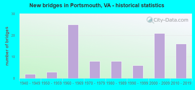
- New bridges - historical statistics
- 21940-1949
- 31950-1959
- 251960-1969
- 81970-1979
- 81980-1989
- 61990-1999
- 212000-2009
- 162010-2019
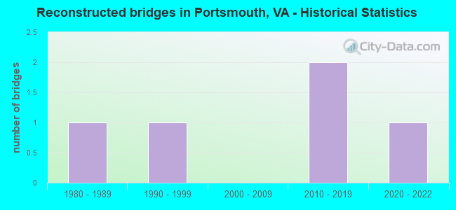
- Reconstructed bridges - Historical Statistics
- 11980-1989
- 11990-1999
- 02000-2009
- 22010-2019
- 12020-2022
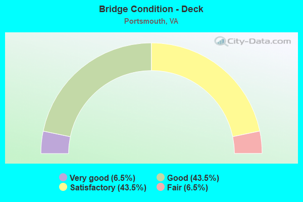
- Bridge Condition - Deck
- 6.5%Very good
- 43.5%Good
- 43.5%Satisfactory
- 6.5%Fair
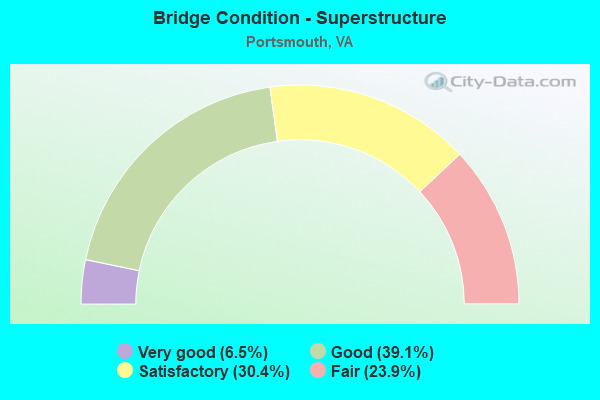
- Bridge Condition - Superstructure
- 6.5%Very good
- 39.1%Good
- 30.4%Satisfactory
- 23.9%Fair
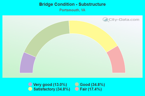
- Bridge Condition - Substructure
- 13.0%Very good
- 34.8%Good
- 34.8%Satisfactory
- 17.4%Fair
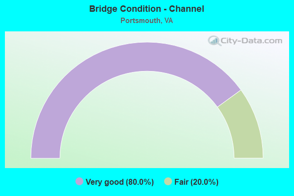
- Bridge Condition - Channel
- 80.0%Very good
- 20.0%Fair
Find on map >> Show street view
Structure Number: 30133, Location: 0.75 Mi fr 264 (Lat: 36.825172, Lng: -76.325494), Route carried "on" structure: US 164, Year Built: 2016, Status: Open, Structure Length: 117.56m (385.70ft), Average Daily Traffic: 33,762 (year 2014), Average Future Daily Traffic: 45,739 (year 2035), Design Load: HL 93, Features Intersected: I-264; Columbu; High, Facility Carried by Structure: MLK EXP - MAINLINE
Minimum Vertical Clearance: 30+ m (98+ ft), Kilometerpoint: 11.265, Lanes on structure: 2, Lanes under structure: 15, Base Highway Network: Yes, Owner: State Highway Agency, Maintenance Responsibility: Private, Approaching Roadway Width: 12.8m (42.0ft), Skew: 19 degrees, Material/Design: Steel continuous, Design/Construction: Stringer/Multi-beam, Number Of Spans In Main Unit: 26, Length of Maximum Span: 79.2m (259.8ft), Curb-To-Curb Width: 18.5m (60.7ft), Out-to-Out Width: 20.1m (65.9ft)
Condition: Deck: Good, Superstructure: Good, Substructure: Very good, Operating Rating: 58.1 metric tons, Method Used To Determine Operating Rating: Load and Resistance Factor (LRFR), Inventory Rating: 45.0 metric tons, Method Used To Determine Inventory Rating: Load and Resistance Factor (LRFR), Structural Evaluation: Better than present minimum criteria, Deck Geometry: Superior to present desirable criteria, Underclear: Equal to present minimum criteria, Approach Roadway Alignment: Better than present minimum criteria, Designated Inspection Frequency: Every 24 months, Inspection Date: October 2020, Deck Structure Type: Concrete Cast-file-Place, Wearing Surface/Protective System: Wearing Surface: Monolithic Concrete, Deck Protection: Epoxy Coated Reinforcing
Find on map >> Show street view
Structure Number: 30134, Location: 0.38 Mi Fr I-264 WB (Lat: 36.832850, Lng: -76.326653), Route carried "on" structure: US , Year Built: 2016, Status: Open, Structure Length: 8.90m (29.20ft), Average Daily Traffic: 24,098 (year 2014), Average Future Daily Traffic: 32,646 (year 2035), Design Load: HL 93, Features Intersected: Pond, Facility Carried by Structure: MLK EXP - RAMP N
Minimum Vertical Clearance: 30+ m (98+ ft), Kilometerpoint: 0.000, Lanes on structure: 2, Base Highway Network: Yes, Owner: State Highway Agency, Maintenance Responsibility: Private, Approaching Roadway Width: 12.8m (42.0ft), Material/Design: Prestressed concrete continuous, Design/Construction: Stringer/Multi-beam, Number Of Spans In Main Unit: 3, Length of Maximum Span: 38.1m (125.0ft), Curb-To-Curb Width: 12.8m (42.0ft), Out-to-Out Width: 13.8m (45.3ft)
Condition: Deck: Good, Superstructure: Very good, Substructure: Very good, Operating Rating: 71.9 metric tons, Method Used To Determine Operating Rating: Load and Resistance Factor (LRFR), Inventory Rating: 54.7 metric tons, Method Used To Determine Inventory Rating: Load and Resistance Factor (LRFR), Structural Evaluation: Equal to present desirable criteria, Deck Geometry: Equal to present desirable criteria, Approach Roadway Alignment: Better than present minimum criteria, Designated Inspection Frequency: Every 24 months, Inspection Date: October 2020, Deck Structure Type: Concrete Cast-file-Place, Wearing Surface/Protective System: Wearing Surface: Monolithic Concrete, Deck Protection: Epoxy Coated Reinforcing
Find on map >> Show street view
Structure Number: 30135, Location: 0.38 Mi Fr I-264 WB (Lat: 36.832500, Lng: -76.327083), Route carried "on" structure: Ramp US 16, Year Built: 2016, Status: Open, Structure Length: 12.65m (41.50ft), Average Daily Traffic: 9,665 (year 2014), Average Future Daily Traffic: 13,093 (year 2035), Design Load: HL 93, Features Intersected: Pond, Facility Carried by Structure: MLK EXP - RAMP S
Minimum Vertical Clearance: 30+ m (98+ ft), Kilometerpoint: 0.000, Lanes on structure: 1, Owner: State Highway Agency, Maintenance Responsibility: Private, Approaching Roadway Width: 9.1m (29.9ft), Material/Design: Prestressed concrete continuous, Design/Construction: Stringer/Multi-beam, Number Of Spans In Main Unit: 4, Length of Maximum Span: 38.1m (125.0ft), Curb-To-Curb Width: 9.1m (29.9ft), Out-to-Out Width: 10.2m (33.5ft)
Condition: Deck: Very good, Superstructure: Very good, Substructure: Very good, Operating Rating: 70.5 metric tons, Method Used To Determine Operating Rating: Load and Resistance Factor (LRFR), Inventory Rating: 50.9 metric tons, Method Used To Determine Inventory Rating: Load and Resistance Factor (LRFR), Structural Evaluation: Equal to present desirable criteria, Deck Geometry: Superior to present desirable criteria, Approach Roadway Alignment: Better than present minimum criteria, Designated Inspection Frequency: Every 24 months, Inspection Date: October 2020, Deck Structure Type: Concrete Cast-file-Place, Wearing Surface/Protective System: Wearing Surface: Monolithic Concrete, Deck Protection: Epoxy Coated Reinforcing
Find on map >> Show street view
Structure Number: 30136, Location: 0.3 Mi Fr I-264 (Lat: 36.821547, Lng: -76.332917), Route carried "on" structure: Ramp US 164, Year Built: 2016, Status: Open, Structure Length: 20.48m (67.19ft), Average Daily Traffic: 7,493 (year 2020), Average Future Daily Traffic: 8,242 (year 2040), Design Load: HL 93, Features Intersected: FREDERICK BLVD, Facility Carried by Structure: MLK EXP - RAMP EN
Minimum Vertical Clearance: 30+ m (98+ ft), Kilometerpoint: 14.484, Lanes on structure: 1, Lanes under structure: 5, Owner: State Highway Agency, Maintenance Responsibility: Private, Approaching Roadway Width: 9.1m (29.9ft), Skew: 9 degrees, Material/Design: Prestressed concrete continuous, Design/Construction: Stringer/Multi-beam, Number Of Spans In Main Unit: 6, Length of Maximum Span: 42.7m (140.1ft), Curb-To-Curb Width: 9.1m (29.9ft), Out-to-Out Width: 10.1m (33.1ft)
Condition: Deck: Very good, Superstructure: Good, Substructure: Very good, Operating Rating: 63.8 metric tons, Method Used To Determine Operating Rating: Load and Resistance Factor (LRFR), Inventory Rating: 49.2 metric tons, Method Used To Determine Inventory Rating: Load and Resistance Factor (LRFR), Structural Evaluation: Better than present minimum criteria, Deck Geometry: Superior to present desirable criteria, Underclear: Meets minimum limits, Approach Roadway Alignment: Better than present minimum criteria, Designated Inspection Frequency: Every 24 months, Inspection Date: October 2020, Deck Structure Type: Concrete Cast-file-Place, Wearing Surface/Protective System: Wearing Surface: Monolithic Concrete, Deck Protection: Epoxy Coated Reinforcing
Find on map >> Show street view
Structure Number: 30137, Location: 0.5 Mi Fr I-264 (Lat: 36.823544, Lng: -76.329694), Route carried "on" structure: Ramp US 164, Year Built: 2016, Status: Open, Structure Length: 13.69m (44.91ft), Average Daily Traffic: 7,493 (year 2020), Average Future Daily Traffic: 8,242 (year 2040), Design Load: HL 93, Features Intersected: NORFOLK & PORTS BELT RR, Facility Carried by Structure: MLK EXP - RAMP NE
Minimum Vertical Clearance: 30+ m (98+ ft), Kilometerpoint: 0.000, Lanes on structure: 1, Owner: State Highway Agency, Maintenance Responsibility: Private, Approaching Roadway Width: 9.1m (29.9ft), Material/Design: Steel continuous, Design/Construction: Stringer/Multi-beam, Number Of Spans In Main Unit: 3, Length of Maximum Span: 48.2m (158.1ft), Curb-To-Curb Width: 9.1m (29.9ft), Out-to-Out Width: 10.1m (33.1ft)
Condition: Deck: Good, Superstructure: Good, Substructure: Very good, Operating Rating: 72.8 metric tons, Method Used To Determine Operating Rating: Load and Resistance Factor (LRFR), Inventory Rating: 56.2 metric tons, Method Used To Determine Inventory Rating: Load and Resistance Factor (LRFR), Structural Evaluation: Better than present minimum criteria, Deck Geometry: Superior to present desirable criteria, Underclear: Superior to present desirable criteria, Approach Roadway Alignment: Better than present minimum criteria, Designated Inspection Frequency: Every 24 months, Inspection Date: October 2020, Deck Structure Type: Concrete Cast-file-Place, Wearing Surface/Protective System: Wearing Surface: Monolithic Concrete, Deck Protection: Epoxy Coated Reinforcing
Find on map >> Show street view
Structure Number: 30138, Location: 0.00 Mi Fr I-264 (Lat: 36.827714, Lng: -76.323150), Route carried "on" structure: Ramp US 164, Year Built: 2016, Status: Open, Structure Length: 27.61m (90.58ft), Average Daily Traffic: 24,098 (year 2014), Average Future Daily Traffic: 32,646 (year 2035), Design Load: HL 93, Features Intersected: UNKNOWN, Facility Carried by Structure: MLK EXP - RAMP WN
Minimum Vertical Clearance: 30+ m (98+ ft), Kilometerpoint: 0.000, Lanes on structure: 1, Lanes under structure: 2, Owner: State Highway Agency, Maintenance Responsibility: Private, Approaching Roadway Width: 9.1m (29.9ft), Material/Design: Steel continuous, Design/Construction: Stringer/Multi-beam, Number Of Spans In Main Unit: 5, Length of Maximum Span: 73.2m (240.2ft), Curb-To-Curb Width: 9.1m (29.9ft), Out-to-Out Width: 10.1m (33.1ft)
Condition: Deck: Good, Superstructure: Good, Substructure: Good, Operating Rating: 76.7 metric tons, Method Used To Determine Operating Rating: Load and Resistance Factor (LRFR), Inventory Rating: 59.4 metric tons, Method Used To Determine Inventory Rating: Load and Resistance Factor (LRFR), Structural Evaluation: Better than present minimum criteria, Deck Geometry: Superior to present desirable criteria, Underclear: Better than present minimum criteria, Approach Roadway Alignment: Better than present minimum criteria, Designated Inspection Frequency: Every 24 months, Inspection Date: October 2020, Deck Structure Type: Concrete Cast-file-Place, Wearing Surface/Protective System: Wearing Surface: Monolithic Concrete, Deck Protection: Epoxy Coated Reinforcing
Find on map >> Show street view
Structure Number: 30139, Location: 0.00 Mi To I-264 (Lat: 36.827639, Lng: -76.326028), Route carried "on" structure: US , Year Built: 2016, Status: Open, Structure Length: 14.36m (47.11ft), Average Daily Traffic: 9,665 (year 2014), Average Future Daily Traffic: 13,093 (year 2035), Design Load: HL 93, Features Intersected: UNKNOWN, Facility Carried by Structure: MLK EXP - RAMP SW
Minimum Vertical Clearance: 30+ m (98+ ft), Kilometerpoint: 0.000, Lanes on structure: 1, Lanes under structure: 2, Owner: State Highway Agency, Maintenance Responsibility: Private, Approaching Roadway Width: 9.1m (29.9ft), Material/Design: Steel continuous, Design/Construction: Stringer/Multi-beam, Number Of Spans In Main Unit: 3, Length of Maximum Span: 55.5m (182.1ft), Curb-To-Curb Width: 9.1m (29.9ft), Out-to-Out Width: 10.1m (33.1ft)
Condition: Deck: Good, Superstructure: Good, Substructure: Very good, Operating Rating: 76.7 metric tons, Method Used To Determine Operating Rating: Load and Resistance Factor (LRFR), Inventory Rating: 59.4 metric tons, Method Used To Determine Inventory Rating: Load and Resistance Factor (LRFR), Structural Evaluation: Better than present minimum criteria, Deck Geometry: Meets minimum limits, Underclear: Meets minimum limits, Approach Roadway Alignment: Better than present minimum criteria, Designated Inspection Frequency: Every 24 months, Inspection Date: October 2020, Deck Structure Type: Concrete Cast-file-Place, Wearing Surface/Protective System: Wearing Surface: Monolithic Concrete
Find on map >> Show street view
Structure Number: 2119, Location: 0.37 MI FR 58 AIRLINE BD (Lat: 36.799372, Lng: -76.377475), Route carried "under" structure: Interstate 264, Year Built: 1976, Structure Length: 0. m, Average Daily Traffic: 46,348 (year 2008), Truck Traffic: 2%, Features Intersected: IS 264, Facility Carried by Structure: Greenwood Drive
Minimum Vertical Clearance: 4.96m (16.27ft), Kilometerpoint: 2.494, Lanes on structure: 6, Lanes under structure: 6, Material/Design: Steel continuous, Design/Construction: Stringer/Multi-beam, Length of Maximum Span: 38.1m (125.0ft)
Find on map >> Show street view
Structure Number: 21193, Location: Downtown Tun. Portsmouth (Lat: 36.831139, Lng: -76.300731), Route carried "under" structure: Interstate 264, Year Built: 1951, Structure Length: 0. m, Average Daily Traffic: 28,810 (year 1994), Features Intersected: IS 264 WBL, Facility Carried by Structure: Court Street
Minimum Vertical Clearance: 4.34m (14.24ft), Kilometerpoint: 11.118, Lanes on structure: 7, Lanes under structure: 2, Material/Design: Prestressed concrete, Design/Construction: Slab, Length of Maximum Span: 9.8m (32.2ft)
Find on map >> Show street view
Structure Number: 21193, Location: Downtown Tun. Portsmouth (Lat: 36.831139, Lng: -76.300731), Route carried "under" structure: Alternate US 460, Year Built: 1951, Structure Length: 0. m, Average Daily Traffic: 28,810 (year 1994), Features Intersected: IS 264 WBL, Facility Carried by Structure: Court Street
Minimum Vertical Clearance: 4.34m (14.24ft), Kilometerpoint: 11.649, Lanes on structure: 7, Lanes under structure: 2, Material/Design: Prestressed concrete, Design/Construction: Slab, Length of Maximum Span: 9.8m (32.2ft)
Find on map >> Show street view
Structure Number: 21195, Location: 0.2 MI.FR.CHURCHLANDBLVD (Lat: 36.869725, Lng: -76.401058), Route carried "under" structure: State highway 164, Year Built: 1989, Structure Length: 0. m, Average Daily Traffic: 49,055 (year 2008), Truck Traffic: 4%, Features Intersected: SR164 & CWRR, Facility Carried by Structure: Town Point Road
Minimum Vertical Clearance: 5.94m (19.49ft), Kilometerpoint: 4.055, Lanes on structure: 5, Lanes under structure: 6, Material/Design: Prestressed concrete, Design/Construction: Stringer/Multi-beam, Length of Maximum Span: 19.7m (64.6ft)
Find on map >> Show street view
Structure Number: 21197, Location: 0.20 MI.FR.W.NORFOLK RD. (Lat: 36.872331, Lng: -76.378086), Route carried "under" structure: State highway 164, Year Built: 1989, Structure Length: 0. m, Average Daily Traffic: 44,552 (year 2008), Truck Traffic: 4%, Features Intersected: SR 164 & CWRR, Facility Carried by Structure: Cedar Lane
Minimum Vertical Clearance: 7.25m (23.79ft), Kilometerpoint: 6.162, Lanes on structure: 4, Lanes under structure: 6, Material/Design: Prestressed concrete, Design/Construction: Stringer/Multi-beam, Length of Maximum Span: 24.4m (80.1ft)
Find on map >> Show street view
Structure Number: 212, Location: 1.57TUNNL ENT/0.84 TO 17 (Lat: 36.837600, Lng: -76.331081), Route carried "under" structure: City street , Year Built: 1971, Structure Length: 0. m, Average Daily Traffic: 20 (year 1994), Truck Traffic: 10%, Features Intersected: N&P RAILWAY & VA AVE, Facility Carried by Structure: LONDON BOULEVARD
Minimum Vertical Clearance: 7.01m (23.00ft), Kilometerpoint: 0.000, Lanes on structure: 4, Lanes under structure: 2, Material/Design: Steel, Design/Construction: Stringer/Multi-beam, Length of Maximum Span: 24.7m (81.0ft)
Find on map >> Show street view
Structure Number: 21202, Location: 1.52TUNNL ENT/0.91 TO 17 (Lat: 36.837717, Lng: -76.328900), Route carried "under" structure: City street , Year Built: 1971, Structure Length: 0. m, Average Daily Traffic: 4,410 (year 1994), Features Intersected: MARTIN LUTHER KING JR FW, Facility Carried by Structure: LONDON BOULEVARD
Minimum Vertical Clearance: 4.85m (15.91ft), Kilometerpoint: 0.000, Lanes on structure: 4, Lanes under structure: 4, Material/Design: Steel, Design/Construction: Stringer/Multi-beam, Length of Maximum Span: 32.3m (106.0ft)
Find on map >> Show street view
Structure Number: 2121, Location: 1.65 MI.FR.INT.CEDAR LANE (Lat: 36.865319, Lng: -76.352750), Route carried "under" structure: Alternate City street , Year Built: 1991, Structure Length: 0. m, Average Daily Traffic: 1,000 (year 1994), Features Intersected: W Norfolk Rd & N&W RR, Facility Carried by Structure: SR 164 EBL
Minimum Vertical Clearance: 7.13m (23.39ft), Kilometerpoint: 8.335, Lanes on structure: 3, Lanes under structure: 6, Material/Design: Steel continuous, Design/Construction: Stringer/Multi-beam, Length of Maximum Span: 49.1m (161.1ft)
Find on map >> Show street view
Structure Number: 21212, Location: 1.65 MI.TO INT.CEDAR LANE (Lat: 36.865153, Lng: -76.352250), Route carried "under" structure: Alternate City street , Year Built: 1991, Structure Length: 0. m, Average Daily Traffic: 1,000 (year 1994), Features Intersected: W Norfolk Rd & N&W RR, Facility Carried by Structure: SR 164 WBL
Minimum Vertical Clearance: 8.93m (29.30ft), Kilometerpoint: 8.335, Lanes on structure: 3, Lanes under structure: 5, Material/Design: Steel continuous, Design/Construction: Stringer/Multi-beam, Length of Maximum Span: 46.6m (152.9ft)
Find on map >> Show street view
Structure Number: 21215, Location: 0.45 MI.FR.W.NORFOLK RD. (Lat: 36.859467, Lng: -76.349200), Route carried "under" structure: Business City street , Year Built: 1978, Structure Length: 0. m, Average Daily Traffic: 100 (year 1994), Features Intersected: W Br Elizabeth River, Facility Carried by Structure: SR 164
Minimum Vertical Clearance: 7.29m (23.92ft), Kilometerpoint: 0.000, Lanes on structure: 4, Lanes under structure: 2, Material/Design: Steel continuous, Design/Construction: Stringer/Multi-beam, Length of Maximum Span: 48.8m (160.1ft)
Find on map >> Show street view
Structure Number: 21218, Location: 0.28 MI FROM INT SR 337 (Lat: 36.818311, Lng: -76.344153), Route carried "under" structure: City street , Year Built: 1964, Structure Length: 0. m, Average Daily Traffic: 4,250 (year 1994), Features Intersected: Rodman Ave, Facility Carried by Structure: IS 264
Minimum Vertical Clearance: 4.70m (15.42ft), Kilometerpoint: 0.000, Lanes on structure: 8, Lanes under structure: 3, Material/Design: Steel, Design/Construction: Stringer/Multi-beam, Length of Maximum Span: 18.3m (60.0ft)
Find on map >> Show street view
Structure Number: 2122, Location: 0.33 MI FROM INT SR 239 (Lat: 36.810439, Lng: -76.351975), Route carried "under" structure: City street , Year Built: 1964, Structure Length: 0. m, Average Daily Traffic: 3,485 (year 1994), Features Intersected: McLean Street, Facility Carried by Structure: IS 264
Minimum Vertical Clearance: 4.19m (13.75ft), Kilometerpoint: 0.000, Lanes on structure: 7, Lanes under structure: 2, Material/Design: Steel, Design/Construction: Stringer/Multi-beam, Length of Maximum Span: 18.0m (59.1ft)
Find on map >> Show street view
Structure Number: 21222, Location: 0.20 MI FROM US 17 SBL (Lat: 36.821561, Lng: -76.333642), Route carried "under" structure: US 17, Year Built: 1964, Structure Length: 0. m, Average Daily Traffic: 25,500 (year 1994), Features Intersected: US 17 Frederick Blvd, Facility Carried by Structure: IS 264 EBL Ramp
Minimum Vertical Clearance: 4.95m (16.24ft), Kilometerpoint: 9.863, Lanes on structure: 1, Lanes under structure: 4, Material/Design: Steel, Design/Construction: Stringer/Multi-beam, Length of Maximum Span: 19.0m (62.3ft)
Find on map >> Show street view
Structure Number: 21225, Location: 0.75 Mi From SR 239 (Lat: 36.815219, Lng: -76.347769), Route carried "under" structure: State highway 337, Year Built: 1964, Structure Length: 0. m, Average Daily Traffic: 10,100 (year 1994), Features Intersected: SR 337 Portsmouth Blvd, Facility Carried by Structure: IS 264
Minimum Vertical Clearance: 4.80m (15.75ft), Kilometerpoint: 27.128, Lanes on structure: 7, Lanes under structure: 4, Material/Design: Steel, Design/Construction: Stringer/Multi-beam, Length of Maximum Span: 16.8m (55.1ft)
Find on map >> Show street view
Structure Number: 21227, Location: 0.37fr.rte337 0.21frI-264 (Lat: 36.815133, Lng: -76.345697), Route carried "under" structure: State highway 337, Year Built: 1964, Structure Length: 0. m, Average Daily Traffic: 16,500 (year 1994), Features Intersected: SR 337 Portsmouth Blvd, Facility Carried by Structure: IS 264 EBL Ramp
Minimum Vertical Clearance: 4.60m (15.09ft), Kilometerpoint: 26.935, Lanes on structure: 1, Lanes under structure: 4, Material/Design: Steel, Design/Construction: Stringer/Multi-beam, Length of Maximum Span: 17.4m (57.1ft)
Find on map >> Show street view
Structure Number: 21229, Location: 0.90 MI FROM INT SR 337 (Lat: 36.821906, Lng: -76.334281), Route carried "under" structure: US 17, Year Built: 1964, Structure Length: 0. m, Average Daily Traffic: 22,500 (year 1994), Features Intersected: US 17 Frederick Blvd, Facility Carried by Structure: IS 264
Minimum Vertical Clearance: 4.65m (15.26ft), Kilometerpoint: 9.767, Lanes on structure: 7, Lanes under structure: 4, Material/Design: Steel, Design/Construction: Stringer/Multi-beam, Length of Maximum Span: 23.9m (78.4ft)
Find on map >> Show street view
Structure Number: 21231, Location: 0.63 MI TO VICTORY BLVD. (Lat: 36.813878, Lng: -76.348769), Route carried "under" structure: Ramp State highway 337, Year Built: 1964, Structure Length: 0. m, Average Daily Traffic: 5,965 (year 1994), Features Intersected: SR 337 EBL Ramp, Facility Carried by Structure: IS 264
Minimum Vertical Clearance: 4.65m (15.26ft), Kilometerpoint: 7.080, Lanes on structure: 8, Lanes under structure: 2, Material/Design: Steel, Design/Construction: Stringer/Multi-beam, Length of Maximum Span: 17.6m (57.7ft)
Find on map >> Show street view
Structure Number: 21233, Location: 00.95 MI TO US 17 (Lat: 36.828350, Lng: -76.319358), Route carried "under" structure: City street , Year Built: 1964, Structure Length: 0. m, Average Daily Traffic: 3,655 (year 1994), Features Intersected: DES MOINES AVE, Facility Carried by Structure: INTERSTATE 264
Minimum Vertical Clearance: 4.50m (14.76ft), Kilometerpoint: 0.000, Lanes on structure: 7, Lanes under structure: 2, Material/Design: Steel, Design/Construction: Stringer/Multi-beam, Length of Maximum Span: 18.3m (60.0ft)
Find on map >> Show street view
Structure Number: 21235, Location: 0.80MI TO SR 337 & US 460 (Lat: 36.821564, Lng: -76.336075), Route carried "under" structure: Ramp Interstate 264, Year Built: 1964, Structure Length: 0. m, Average Daily Traffic: 10,100 (year 1994), Features Intersected: IS 264 EBL On Ramp
Minimum Vertical Clearance: 4.65m (15.26ft), Kilometerpoint: 0.000, Lanes on structure: 7, Lanes under structure: 2, Material/Design: Steel, Design/Construction: Stringer/Multi-beam, Length of Maximum Span: 23.2m (76.1ft)
Find on map >> Show street view
Structure Number: 21237, Location: 1.30 MI TO GREENWOOD DR (Lat: 36.807814, Lng: -76.356942), Route carried "under" structure: State highway 239, Year Built: 1963, Structure Length: 0. m, Average Daily Traffic: 21,650 (year 1994), Features Intersected: SR 239 Victory Blvd, Facility Carried by Structure: IS 264
Minimum Vertical Clearance: 4.45m (14.60ft), Kilometerpoint: 0.933, Lanes on structure: 4, Lanes under structure: 6, Material/Design: Steel, Design/Construction: Stringer/Multi-beam, Length of Maximum Span: 15.8m (51.8ft)
Find on map >> Show street view
Structure Number: 2124, Location: 1.67 MI FROM INT US 17 (Lat: 36.829878, Lng: -76.306925), Route carried "under" structure: State highway 141, Year Built: 1966, Structure Length: 0. m, Average Daily Traffic: 20,250 (year 1994), Features Intersected: SR 141 (EFFINGHAM ST), Facility Carried by Structure: Interstate 264
Minimum Vertical Clearance: 5.08m (16.67ft), Kilometerpoint: 2.607, Lanes on structure: 8, Lanes under structure: 6, Material/Design: Steel, Design/Construction: Stringer/Multi-beam, Length of Maximum Span: 31.4m (103.0ft)
Find on map >> Show street view
Structure Number: 21242, Location: 0.43 MI TO DOWNTOWN TUN (Lat: 36.829114, Lng: -76.309736), Route carried "under" structure: Ramp Interstate 264, Year Built: 1966, Structure Length: 0. m, Average Daily Traffic: 5,975 (year 1994), Features Intersected: CSX TRANSP & WBL 0N-RAMP
Minimum Vertical Clearance: 5.54m (18.18ft), Kilometerpoint: 0.000, Lanes on structure: 7, Lanes under structure: 1, Material/Design: Steel, Design/Construction: Stringer/Multi-beam, Length of Maximum Span: 35.4m (116.1ft)
Find on map >> Show street view
Structure Number: 21244, Location: 1.32 MI FROM INT US 17 (Lat: 36.829364, Lng: -76.312897), Route carried "under" structure: City street , Year Built: 1966, Structure Length: 0. m, Average Daily Traffic: 8,265 (year 1994), Features Intersected: ELM AVENUE, Facility Carried by Structure: INTERSTATE 264
Minimum Vertical Clearance: 4.47m (14.67ft), Kilometerpoint: 0.000, Lanes on structure: 8, Lanes under structure: 2, Material/Design: Steel, Design/Construction: Stringer/Multi-beam, Length of Maximum Span: 24.4m (80.1ft)
Find on map >> Show street view
Structure Number: 21246, Location: 0.19 WEST OF JCT COURT ST (Lat: 36.831486, Lng: -76.304092), Route carried "under" structure: Ramp Interstate 264, Year Built: 1985, Structure Length: 0. m, Average Daily Traffic: 4,450 (year 1994), Features Intersected: IS 264 WB OFF-RAMP
Minimum Vertical Clearance: 5.39m (17.68ft), Kilometerpoint: 0.000, Lanes on structure: 1, Lanes under structure: 1, Material/Design: Steel, Design/Construction: Stringer/Multi-beam, Length of Maximum Span: 38.1m (125.0ft)
Find on map >> Show street view
Structure Number: 21248, Location: INT. @ DOWNTOWN TUN PORTS (Lat: 36.830125, Lng: -76.305061), Route carried "under" structure: Ramp Interstate 264, Year Built: 1985, Structure Length: 0. m, Average Daily Traffic: 8,950 (year 1994), Features Intersected: IS 264 EBL ON RAMPS
Minimum Vertical Clearance: 5.18m (16.99ft), Kilometerpoint: 0.000, Lanes on structure: 1, Lanes under structure: 2, Material/Design: Steel continuous, Design/Construction: Stringer/Multi-beam, Length of Maximum Span: 32.0m (105.0ft)
Find on map >> Show street view
Structure Number: 26653, Location: 0.89 MI TO MIDTOWN TUNNEL (Lat: 36.846514, Lng: -76.329272), Route carried "under" structure: City street , Year Built: 2005, Structure Length: 0. m, Average Daily Traffic: 4,250 (year 1994), Truck Traffic: 50%, Features Intersected: CSX R/R & STREETS, Facility Carried by Structure: US 58 & RAMP F
Minimum Vertical Clearance: 7.57m (24.84ft), Kilometerpoint: 0.000, Lanes on structure: 9, Lanes under structure: 2, Material/Design: Steel continuous, Design/Construction: Stringer/Multi-beam, Length of Maximum Span: 46.9m (153.9ft)
Find on map >> Show street view
Structure Number: 26653, Location: 0.89 MI TO MIDTOWN TUNNEL (Lat: 36.846514, Lng: -76.329272), Route carried "under" structure: City street , Year Built: 2005, Structure Length: 0. m, Average Daily Traffic: 8,500 (year 1994), Truck Traffic: 50%, Features Intersected: CSX R/R & STREETS, Facility Carried by Structure: US 58 & RAMP F
Minimum Vertical Clearance: 7.47m (24.51ft), Kilometerpoint: 0.000, Lanes on structure: 9, Lanes under structure: 4, Material/Design: Steel continuous, Design/Construction: Stringer/Multi-beam, Length of Maximum Span: 46.9m (153.9ft)
Find on map >> Show street view
Structure Number: 28239, Location: 0.90 From Cedar Lane (Lat: 36.868764, Lng: -76.362114), Route carried "under" structure: State highway , Year Built: 2006, Structure Length: 0. m, Average Daily Traffic: 3,000 (year 2005), Features Intersected: APM Blvd, Facility Carried by Structure: SR 164 EBL
Minimum Vertical Clearance: 5.18m (16.99ft), Kilometerpoint: 0.000, Lanes on structure: 2, Lanes under structure: 4, Material/Design: Prestressed concrete, Design/Construction: Stringer/Multi-beam, Length of Maximum Span: 29.6m (97.1ft)
Find on map >> Show street view
Structure Number: 28241, Location: 0.90 MI. FROM CEDAR LANE (Lat: 36.869000, Lng: -76.362033), Route carried "under" structure: Alternate City street , Year Built: 2006, Structure Length: 0. m, Average Daily Traffic: 3,000 (year 2005), Truck Traffic: 4%, Features Intersected: APM Blvd, Facility Carried by Structure: SR 164 WBL
Minimum Vertical Clearance: 5.21m (17.09ft), Kilometerpoint: 190.667, Lanes on structure: 2, Lanes under structure: 4, Material/Design: Prestressed concrete, Design/Construction: Stringer/Multi-beam, Length of Maximum Span: 29.6m (97.1ft)
Find on map >> Show street view
Structure Number: 2835, Location: 0.0TO 164 WB/0.1fr RR Ave (Lat: 36.850772, Lng: -76.329344), Route carried "under" structure: US 58, Year Built: 2006, Structure Length: 0. m, Average Daily Traffic: 1,500 (year 2006), Truck Traffic: 10%, Features Intersected: RTE. 58 EB&WB & PMT, Facility Carried by Structure: RAMP "A" of 164
Minimum Vertical Clearance: 8.03m (26.35ft), Kilometerpoint: 0.000, Lanes on structure: 1, Lanes under structure: 5, Material/Design: Steel continuous, Design/Construction: Stringer/Multi-beam, Length of Maximum Span: 40.8m (133.9ft)
Find on map >> Show street view
Structure Number: 28376, Location: 0.00 BEG. 164 (Lat: 36.853242, Lng: -76.331347), Route carried "under" structure: US 58, Year Built: 2006, Structure Length: 0. m, Average Daily Traffic: 10,000 (year 2006), Truck Traffic: 3%, Features Intersected: 58 WBL; 164 EBL & PMT, Facility Carried by Structure: ROUTE 164 WBL
Minimum Vertical Clearance: 6.45m (21.16ft), Kilometerpoint: 0.000, Lanes on structure: 2, Lanes under structure: 3, Material/Design: Steel continuous, Design/Construction: Stringer/Multi-beam, Length of Maximum Span: 57.9m (190.0ft)
Find on map >> Show street view
Structure Number: 28376, Location: 0.00 BEG. 164 (Lat: 36.853242, Lng: -76.331347), Route carried "under" structure: State highway 164, Year Built: 2006, Structure Length: 0. m, Average Daily Traffic: 30,000 (year 2006), Truck Traffic: 10%, Features Intersected: 58 WBL; 164 EBL & PMT
Minimum Vertical Clearance: 5.73m (18.80ft), Kilometerpoint: 0.000, Lanes on structure: 2, Lanes under structure: 2, Material/Design: Steel continuous, Design/Construction: Stringer/Multi-beam, Length of Maximum Span: 57.9m (190.0ft)
Find on map >> Show street view
Structure Number: 28384, Location: 0.00 TO END 164 (Lat: 36.853542, Lng: -76.332125), Route carried "under" structure: Ramp State highway 58, Year Built: 2006, Structure Length: 0. m, Average Daily Traffic: 2,500 (year 2006), Truck Traffic: 10%, Features Intersected: PORT. MARINE TER.&RAMP G, Facility Carried by Structure: ROUTE 164 EBL
Minimum Vertical Clearance: 5.49m (18.01ft), Kilometerpoint: 0.000, Lanes on structure: 2, Lanes under structure: 1, Material/Design: Steel continuous, Design/Construction: Stringer/Multi-beam, Length of Maximum Span: 55.5m (182.1ft)
Find on map >> Show street view
Structure Number: 28396, Location: 00.10 mile fr Midtown Tun (Lat: 36.853622, Lng: -76.332022), Route carried "under" structure: US 58, Year Built: 2006, Structure Length: 0. m, Average Daily Traffic: 30,000 (year 2006), Features Intersected: PORT.MARINE TER. & 58WBL, Facility Carried by Structure: ROUTE 164 EBL
Minimum Vertical Clearance: 5.71m (18.73ft), Kilometerpoint: 0.000, Lanes on structure: 2, Lanes under structure: 2, Material/Design: Steel continuous, Design/Construction: Stringer/Multi-beam, Length of Maximum Span: 56.1m (184.1ft)
Find on map >> Show street view
Structure Number: 30133, Location: 0.75 Mi fr 264 (Lat: 36.825172, Lng: -76.325494), Route carried "under" structure: Interstate 264, Year Built: 2016, Structure Length: 0. m, Features Intersected: I-264; Columbu; High, Facility Carried by Structure: MLK EXP - MAINLINE
Minimum Vertical Clearance: 6.93m (22.74ft), Kilometerpoint: 0.000, Lanes on structure: 2, Lanes under structure: 7, Material/Design: Steel continuous, Design/Construction: Stringer/Multi-beam, Length of Maximum Span: 79.2m (259.8ft)
Find on map >> Show street view
Structure Number: 30133, Location: 0.75 Mi fr 264 (Lat: 36.825172, Lng: -76.325494), Route carried "under" structure: City street , Year Built: 2016, Structure Length: 0. m, Features Intersected: I-264; Columbu; High, Facility Carried by Structure: MLK EXP - MAINLINE
Minimum Vertical Clearance: 5.49m (18.01ft), Kilometerpoint: 0.000, Lanes on structure: 2, Lanes under structure: 2, Material/Design: Steel continuous, Design/Construction: Stringer/Multi-beam, Length of Maximum Span: 79.2m (259.8ft)
Find on map >> Show street view
Structure Number: 30133, Location: 0.75 Mi fr 264 (Lat: 36.825172, Lng: -76.325494), Route carried "under" structure: City street 337, Year Built: 2016, Structure Length: 0. m, Features Intersected: I-264; Columbu; High, Facility Carried by Structure: MLK EXP - MAINLINE
Minimum Vertical Clearance: 5.52m (18.11ft), Kilometerpoint: 0.000, Lanes on structure: 2, Lanes under structure: 2, Material/Design: Steel continuous, Design/Construction: Stringer/Multi-beam, Length of Maximum Span: 79.2m (259.8ft)
Find on map >> Show street view
Structure Number: 30133, Location: 0.75 Mi fr 264 (Lat: 36.825172, Lng: -76.325494), Route carried "under" structure: City street , Year Built: 2016, Structure Length: 0. m, Features Intersected: I-264; Columbu; High, Facility Carried by Structure: MLK EXP - MAINLINE
Minimum Vertical Clearance: 9.42m (30.91ft), Kilometerpoint: 0.000, Lanes on structure: 2, Lanes under structure: 2, Material/Design: Steel continuous, Design/Construction: Stringer/Multi-beam, Length of Maximum Span: 79.2m (259.8ft)
Find on map >> Show street view
Structure Number: 30133, Location: 0.75 Mi fr 264 (Lat: 36.825172, Lng: -76.325494), Route carried "under" structure: City street , Year Built: 2016, Structure Length: 0. m, Features Intersected: I-264; Columbu; High, Facility Carried by Structure: MLK EXP - MAINLINE
Minimum Vertical Clearance: 5.13m (16.83ft), Kilometerpoint: 0.000, Lanes on structure: 2, Lanes under structure: 2, Material/Design: Steel continuous, Design/Construction: Stringer/Multi-beam, Length of Maximum Span: 79.2m (259.8ft)
Find on map >> Show street view
Structure Number: 30136, Location: 0.3 Mi Fr I-264 (Lat: 36.821547, Lng: -76.332917), Route carried "under" structure: Ramp Interstate 264, Year Built: 2016, Structure Length: 0. m, Features Intersected: FREDERICK BLVD, Facility Carried by Structure: MLK EXP - RAMP EN
Minimum Vertical Clearance: 6.00m (19.69ft), Kilometerpoint: 0.000, Lanes on structure: 1, Lanes under structure: 1, Material/Design: Prestressed concrete continuous, Design/Construction: Stringer/Multi-beam, Length of Maximum Span: 42.7m (140.1ft)
Find on map >> Show street view
Structure Number: 30136, Location: 0.3 Mi Fr I-264 (Lat: 36.821547, Lng: -76.332917), Route carried "under" structure: City street 17, Year Built: 2016, Structure Length: 0. m, Features Intersected: FREDERICK BLVD, Facility Carried by Structure: MLK EXP - RAMP EN
Minimum Vertical Clearance: 9.07m (29.76ft), Kilometerpoint: 0.000, Lanes on structure: 1, Lanes under structure: 4, Material/Design: Prestressed concrete continuous, Design/Construction: Stringer/Multi-beam, Length of Maximum Span: 42.7m (140.1ft)
Find on map >> Show street view
Structure Number: 30138, Location: 0.00 Mi Fr I-264 (Lat: 36.827714, Lng: -76.323150), Route carried "under" structure: City street , Year Built: 2016, Structure Length: 0. m, Features Intersected: UNKNOWN, Facility Carried by Structure: MLK EXP - RAMP WN
Minimum Vertical Clearance: 5.28m (17.32ft), Kilometerpoint: 0.000, Lanes on structure: 1, Lanes under structure: 2, Material/Design: Steel continuous, Design/Construction: Stringer/Multi-beam, Length of Maximum Span: 73.2m (240.2ft)
Find on map >> Show street view
Structure Number: 30139, Location: 0.00 Mi To I-264 (Lat: 36.827639, Lng: -76.326028), Route carried "under" structure: City street , Year Built: 2016, Structure Length: 0. m, Features Intersected: UNKNOWN, Facility Carried by Structure: MLK EXP - RAMP SW
Minimum Vertical Clearance: 4.94m (16.21ft), Kilometerpoint: 0.000, Lanes on structure: 1, Lanes under structure: 2, Material/Design: Steel continuous, Design/Construction: Stringer/Multi-beam, Length of Maximum Span: 55.5m (182.1ft)