Bridge Statistics for Poughkeepsie, New York (NY)
Condition, Traffic, Stress, Structural Evaluation, Project Costs
- National Bridge Inventory (NBI) Statistics
- 48Number of bridges
- 272ft / 82.6mTotal length
- $115,773,000Total costs
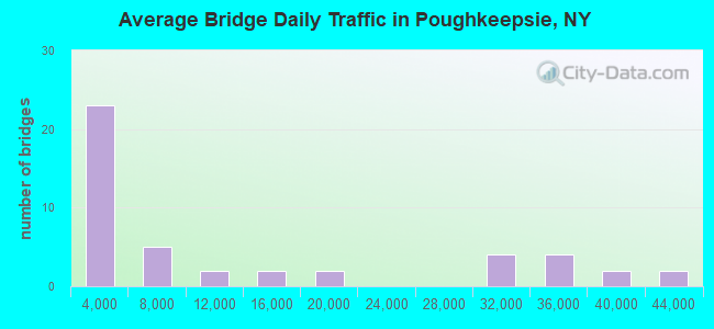
- 571,322Total average daily traffic
- 11,589Total average daily truck traffic
- National Bridge Inventory (NBI) Registered Bridges for Poughkeepsie
- No street view available for this location
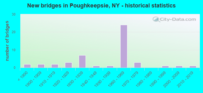
- New bridges - historical statistics
- 2Before 1900
- 21900-1909
- 21910-1919
- 31920-1929
- 71930-1939
- 11940-1949
- 11950-1959
- 241960-1969
- 31970-1979
- 11990-1999
- 12000-2009
- 12010-2019
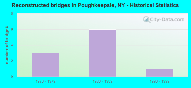
- Reconstructed bridges - Historical Statistics
- 31970-1979
- 61980-1989
- 11990-1999
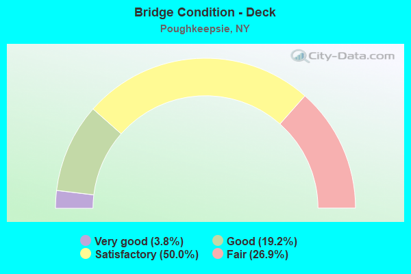
- Bridge Condition - Deck
- 3.8%Very good
- 19.2%Good
- 50.0%Satisfactory
- 26.9%Fair

- Bridge Condition - Superstructure
- 12.9%Very good
- 16.1%Good
- 32.3%Satisfactory
- 29.0%Fair
- 9.7%Poor
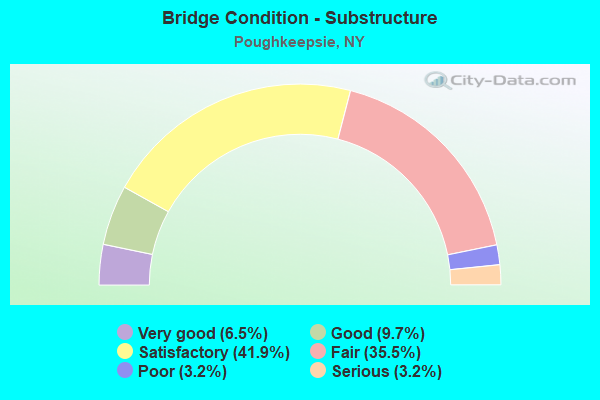
- Bridge Condition - Substructure
- 6.5%Very good
- 9.7%Good
- 41.9%Satisfactory
- 35.5%Fair
- 3.2%Poor
- 3.2%Serious
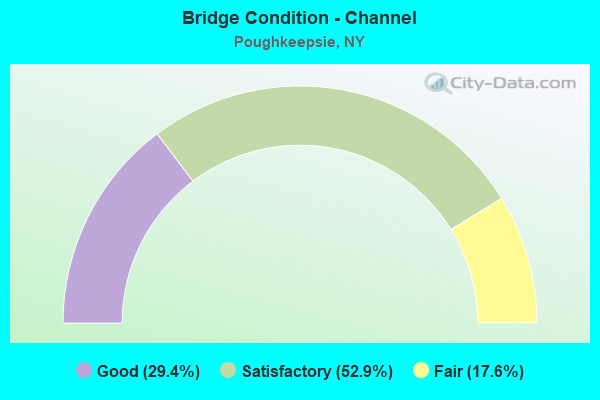
- Bridge Condition - Channel
- 29.4%Good
- 52.9%Satisfactory
- 17.6%Fair
Find on map >> Show street view
Structure Number: 1005249, Location: JCT RTS 9+376 (Lat: 41.687731, Lng: -73.931236), Route carried "on" structure: US 9, Year Built: 1965, Status: Open, Structure Length: 5.18m (16.99ft), Average Daily Traffic: 35,837 (year 2012), Truck Traffic: 2%, Average Future Daily Traffic: 50,555 (year 2040), Design Load: HS 20, Features Intersected: ACADEMY STREET
Minimum Vertical Clearance: 30+ m (98+ ft), Kilometerpoint: 23.202, Lanes on structure: 4, Lanes under structure: 2, Base Highway Network: Yes, Owner: State Highway Agency, Approaching Roadway Width: 15.2m (49.9ft), Skew: 23 degrees, Material/Design: Steel, Design/Construction: Stringer/Multi-beam, Number Of Spans In Main Unit: 3, Length of Maximum Span: 22.2m (72.8ft), Curb-To-Curb Width: 20.8m (68.2ft), Out-to-Out Width: 22.9m (75.1ft)
Condition: Deck: Satisfactory, Superstructure: Fair, Substructure: Satisfactory, Operating Rating: 83.5 metric tons, Method Used To Determine Operating Rating: Load Factor (LF), Inventory Rating: 49.9 metric tons, Method Used To Determine Inventory Rating: Load Factor (LF), Structural Evaluation: Somewhat better than minimum adequacy, Deck Geometry: Equal to present minimum criteria, Underclear: Meets minimum limits, Approach Roadway Alignment: Equal to present desirable criteria, Length Of Structure Improvement: 5.18m (16.99ft), Designated Inspection Frequency: Every 24 months, Inspection Date: April 2021, Bridge Improvement Cost: $4,729,000, Roadway Improvement Cost: $2,769,000, Total Project Cost: $7,498,000 ( Estimate for 2021), Deck Structure Type: Concrete Cast-file-Place, Wearing Surface/Protective System: Wearing Surface: Bituminous, Membrane: Other
Find on map >> Show street view
Structure Number: 1005259, Location: 0.3 MI N JCT RTS 9+376 (Lat: 41.690911, Lng: -73.936100), Route carried "on" structure: US 9, Year Built: 1965, Status: Open, Structure Length: 4.69m (15.39ft), Average Daily Traffic: 35,837 (year 2012), Truck Traffic: 2%, Average Future Daily Traffic: 50,555 (year 2040), Design Load: HS 20, Features Intersected: FOX STREET
Minimum Vertical Clearance: 30+ m (98+ ft), Kilometerpoint: 23.717, Lanes on structure: 4, Lanes under structure: 2, Base Highway Network: Yes, Owner: State Highway Agency, Approaching Roadway Width: 15.2m (49.9ft), Skew: 21 degrees, Material/Design: Steel, Design/Construction: Stringer/Multi-beam, Number Of Spans In Main Unit: 3, Length of Maximum Span: 17.3m (56.8ft), Curb-To-Curb Width: 20.8m (68.2ft), Out-to-Out Width: 23.0m (75.5ft)
Condition: Deck: Satisfactory, Superstructure: Fair, Substructure: Satisfactory, Operating Rating: 33.7 metric tons, Method Used To Determine Operating Rating: Load and Resistance Factor Rating (LRFR) rating reported by rating factor(RF) method using HL-93 loadings, Inventory Rating: 26.2 metric tons, Method Used To Determine Inventory Rating: Load and Resistance Factor Rating (LRFR) rating reported by rating factor(RF) method using HL-93 loadings, Structural Evaluation: Somewhat better than minimum adequacy, Deck Geometry: Equal to present minimum criteria, Underclear: Equal to present minimum criteria, Approach Roadway Alignment: Equal to present desirable criteria, Length Of Structure Improvement: 4.69m (15.39ft), Designated Inspection Frequency: Every 24 months, Inspection Date: March 2021, Bridge Improvement Cost: $4,295,000, Roadway Improvement Cost: $2,515,000, Total Project Cost: $6,810,000 ( Estimate for 2021), Deck Structure Type: Concrete Cast-file-Place, Wearing Surface/Protective System: Wearing Surface: Bituminous, Membrane: Other
Find on map >> Show street view
Structure Number: 100526, Location: .7 MI N JCT US 9 & SH 376 (Lat: 41.695858, Lng: -73.936764), Route carried "on" structure: City street , Year Built: 1965, Status: Open, Structure Length: 2.96m (9.71ft), Average Daily Traffic: 2,770 (year 2020), Truck Traffic: 1%, Average Future Daily Traffic: 3,427 (year 2040), Design Load: HS 20, Features Intersected: 9 9 82052011 NB, RTE 9, Facility Carried by Structure: COLUMBIA STREET
Minimum Vertical Clearance: 30+ m (98+ ft), Kilometerpoint: 0.016, Lanes on structure: 4, Lanes under structure: 4, Owner: State Highway Agency, Approaching Roadway Width: 12.8m (42.0ft), Skew: 2 degrees, Material/Design: Steel, Design/Construction: Stringer/Multi-beam, Number Of Spans In Main Unit: 1, Length of Maximum Span: 28.0m (91.9ft), Curb or Sidewalk Widths: Left: 1.2m (3.9ft), Right: 1.2m (3.9ft), Curb-To-Curb Width: 12.7m (41.7ft), Out-to-Out Width: 15.8m (51.8ft)
Condition: Deck: Satisfactory, Superstructure: Satisfactory, Substructure: Satisfactory, Operating Rating: 59.0 metric tons, Method Used To Determine Operating Rating: Load and Resistance Factor Rating (LRFR) rating reported by rating factor(RF) method using HL-93 loadings, Inventory Rating: 45.4 metric tons, Method Used To Determine Inventory Rating: Load and Resistance Factor Rating (LRFR) rating reported by rating factor(RF) method using HL-93 loadings, Structural Evaluation: Equal to present minimum criteria, Deck Geometry: High priority of replacement, Underclear: High priority of corrective action, Approach Roadway Alignment: Equal to present desirable criteria, Length Of Structure Improvement: 2.95m (9.68ft), Designated Inspection Frequency: Every 24 months, Inspection Date: June 2021, Bridge Improvement Cost: $3,049,000, Roadway Improvement Cost: $1,785,000, Total Project Cost: $4,834,000 ( Estimate for 2021), Deck Structure Type: Concrete Cast-file-Place, Wearing Surface/Protective System: Wearing Surface: Monolithic Concrete
Find on map >> Show street view
Structure Number: 1005279, Location: 0.8 MI N JCT RTS 9+376 (Lat: 41.697442, Lng: -73.936536), Route carried "on" structure: US 9, Year Built: 1965, Year Reconstructed: 1999, Status: Open, Structure Length: 1.77m (5.81ft), Average Daily Traffic: 35,837 (year 2012), Truck Traffic: 2%, Average Future Daily Traffic: 50,555 (year 2040), Design Load: HS 20, Features Intersected: PINE STREET
Minimum Vertical Clearance: 30+ m (98+ ft), Kilometerpoint: 24.505, Lanes on structure: 5, Lanes under structure: 2, Base Highway Network: Yes, Owner: State Highway Agency, Approaching Roadway Width: 18.6m (61.0ft), Skew: 20 degrees, Material/Design: Steel, Design/Construction: Stringer/Multi-beam, Number Of Spans In Main Unit: 1, Length of Maximum Span: 16.4m (53.8ft), Curb-To-Curb Width: 24.5m (80.4ft), Out-to-Out Width: 26.5m (86.9ft)
Condition: Deck: Satisfactory, Superstructure: Satisfactory, Substructure: Fair, Operating Rating: 97.1 metric tons, Method Used To Determine Operating Rating: Load Factor (LF), Inventory Rating: 58.1 metric tons, Method Used To Determine Inventory Rating: Load Factor (LF), Structural Evaluation: Somewhat better than minimum adequacy, Deck Geometry: Equal to present minimum criteria, Underclear: High priority of corrective action, Approach Roadway Alignment: Equal to present desirable criteria, Length Of Structure Improvement: 1.76m (5.77ft), Designated Inspection Frequency: Every 24 months, Inspection Date: June 2021, Bridge Improvement Cost: $3,998,000, Roadway Improvement Cost: $2,341,000, Total Project Cost: $6,340,000 ( Estimate for 2021), Deck Structure Type: Concrete Cast-file-Place, Wearing Surface/Protective System: Wearing Surface: Bituminous, Membrane: Other
Find on map >> Show street view
Structure Number: 1005281, Location: 1.0 MI N JCT RTS 9+376 (Lat: 41.700308, Lng: -73.936794), Route carried "on" structure: US 9, Year Built: 1965, Status: Open, Structure Length: 3.69m (12.11ft), Average Daily Traffic: 17,919 (year 2012), Truck Traffic: 2%, Average Future Daily Traffic: 25,277 (year 2040), Design Load: HS 20, Features Intersected: LAUREL STREET
Minimum Vertical Clearance: 30+ m (98+ ft), Kilometerpoint: 24.811, Lanes on structure: 2, Lanes under structure: 2, Base Highway Network: Yes, Owner: State Highway Agency, Approaching Roadway Width: 11.0m (36.1ft), Material/Design: Steel, Design/Construction: Stringer/Multi-beam, Number Of Spans In Main Unit: 3, Length of Maximum Span: 16.1m (52.8ft), Curb-To-Curb Width: 11.0m (36.1ft), Out-to-Out Width: 12.2m (40.0ft)
Condition: Deck: Satisfactory, Superstructure: Poor, Substructure: Satisfactory, Operating Rating: 48.1 metric tons, Method Used To Determine Operating Rating: Load Factor (LF), Inventory Rating: 29.0 metric tons, Method Used To Determine Inventory Rating: Load Factor (LF), Structural Evaluation: Meets minimum limits, Deck Geometry: Somewhat better than minimum adequacy, Underclear: Somewhat better than minimum adequacy, Approach Roadway Alignment: Equal to present desirable criteria, Length Of Structure Improvement: 3.68m (12.07ft), Designated Inspection Frequency: Every 24 months, Inspection Date: September 2021, Bridge Improvement Cost: $1,801,000, Roadway Improvement Cost: $1,054,000, Total Project Cost: $2,855,000 ( Estimate for 2021), Deck Structure Type: Concrete Cast-file-Place, Wearing Surface/Protective System: Wearing Surface: Bituminous, Membrane: Other
Find on map >> Show street view
Structure Number: 1005282, Location: 1.0 MI N JCT RTS 9+376 (Lat: 41.700292, Lng: -73.936178), Route carried "on" structure: US 9, Year Built: 1965, Status: Open, Structure Length: 3.75m (12.30ft), Average Daily Traffic: 17,919 (year 2012), Truck Traffic: 2%, Average Future Daily Traffic: 25,277 (year 2040), Design Load: HS 20, Features Intersected: LAUREL STREET
Minimum Vertical Clearance: 30+ m (98+ ft), Kilometerpoint: 24.811, Lanes on structure: 2, Lanes under structure: 2, Base Highway Network: Yes, Owner: State Highway Agency, Approaching Roadway Width: 11.0m (36.1ft), Material/Design: Steel, Design/Construction: Stringer/Multi-beam, Number Of Spans In Main Unit: 3, Length of Maximum Span: 16.1m (52.8ft), Curb-To-Curb Width: 11.0m (36.1ft), Out-to-Out Width: 12.2m (40.0ft)
Condition: Deck: Fair, Superstructure: Fair, Substructure: Good, Operating Rating: 43.5 metric tons, Method Used To Determine Operating Rating: Load Factor (LF), Inventory Rating: 25.4 metric tons, Method Used To Determine Inventory Rating: Load Factor (LF), Structural Evaluation: Somewhat better than minimum adequacy, Deck Geometry: Somewhat better than minimum adequacy, Underclear: Somewhat better than minimum adequacy, Approach Roadway Alignment: Equal to present desirable criteria, Length Of Structure Improvement: 3.74m (12.27ft), Designated Inspection Frequency: Every 24 months, Inspection Date: October 2021, Bridge Improvement Cost: $1,826,000, Roadway Improvement Cost: $1,069,000, Total Project Cost: $2,895,000 ( Estimate for 2021), Deck Structure Type: Concrete Cast-file-Place, Wearing Surface/Protective System: Wearing Surface: Bituminous, Membrane: Other
Find on map >> Show street view
Structure Number: 100529, Location: JCT US 9 & US 44 / SH 55 (Lat: 41.702614, Lng: -73.936031), Route carried "on" structure: US 44, Year Built: 1965, Status: Open, Structure Length: 1.58m (5.18ft), Average Daily Traffic: 34,647 (year 2020), Truck Traffic: 4%, Average Future Daily Traffic: 48,876 (year 2040), Design Load: HS 20, Features Intersected: RTE 9
Minimum Vertical Clearance: 30+ m (98+ ft), Kilometerpoint: 0.837, Lanes on structure: 4, Lanes under structure: 2, Base Highway Network: Yes, Owner: State Highway Agency, Approaching Roadway Width: 16.2m (53.1ft), Material/Design: Steel, Design/Construction: Stringer/Multi-beam, Number Of Spans In Main Unit: 1, Length of Maximum Span: 14.6m (47.9ft), Curb or Sidewalk Widths: Left: 1.3m (4.3ft), Right: 1.3m (4.3ft), Curb-To-Curb Width: 16.8m (55.1ft), Out-to-Out Width: 20.0m (65.6ft)
Condition: Deck: Satisfactory, Superstructure: Fair, Substructure: Fair, Operating Rating: 94.0 metric tons, Method Used To Determine Operating Rating: Load and Resistance Factor Rating (LRFR) rating reported by rating factor(RF) method using HL-93 loadings, Inventory Rating: 72.6 metric tons, Method Used To Determine Inventory Rating: Load and Resistance Factor Rating (LRFR) rating reported by rating factor(RF) method using HL-93 loadings, Structural Evaluation: Somewhat better than minimum adequacy, Deck Geometry: High priority of replacement, Underclear: High priority of corrective action, Approach Roadway Alignment: Equal to present desirable criteria, Length Of Structure Improvement: 1.58m (5.18ft), Designated Inspection Frequency: Every 24 months, Inspection Date: October 2020, Bridge Improvement Cost: $2,651,000, Roadway Improvement Cost: $1,552,000, Total Project Cost: $4,204,000 ( Estimate for 2021), Deck Structure Type: Concrete Cast-file-Place, Wearing Surface/Protective System: Wearing Surface: Monolithic Concrete
Find on map >> Show street view
Structure Number: 1005301, Location: 0.2 MI N JCT RTS 9+44+55 (Lat: 41.705628, Lng: -73.937108), Route carried "on" structure: US 9, Year Built: 1965, Year Reconstructed: 1991, Status: Open, Structure Length: 4.60m (15.09ft), Average Daily Traffic: 15,031 (year 2008), Truck Traffic: 3%, Average Future Daily Traffic: 21,204 (year 2040), Design Load: HS 20, Features Intersected: MAIN STREET
Minimum Vertical Clearance: 30+ m (98+ ft), Kilometerpoint: 25.422, Lanes on structure: 2, Lanes under structure: 2, Base Highway Network: Yes, Owner: State Highway Agency, Approaching Roadway Width: 11.0m (36.1ft), Material/Design: Steel, Design/Construction: Stringer/Multi-beam, Number Of Spans In Main Unit: 3, Length of Maximum Span: 19.2m (63.0ft), Curb-To-Curb Width: 11.0m (36.1ft), Out-to-Out Width: 12.2m (40.0ft)
Condition: Deck: Satisfactory, Superstructure: Fair, Substructure: Fair, Operating Rating: 98.0 metric tons, Method Used To Determine Operating Rating: Load Factor (LF), Inventory Rating: 58.1 metric tons, Method Used To Determine Inventory Rating: Load Factor (LF), Structural Evaluation: Somewhat better than minimum adequacy, Deck Geometry: Somewhat better than minimum adequacy, Underclear: Equal to present minimum criteria, Approach Roadway Alignment: Equal to present desirable criteria, Length Of Structure Improvement: 4.60m (15.09ft), Designated Inspection Frequency: Every 24 months, Inspection Date: September 2021, Bridge Improvement Cost: $2,233,000, Roadway Improvement Cost: $1,307,000, Total Project Cost: $3,540,000 ( Estimate for 2021), Deck Structure Type: Concrete Cast-file-Place, Wearing Surface/Protective System: Wearing Surface: Bituminous, Membrane: Other
Find on map >> Show street view
Structure Number: 1005302, Location: 0.2 MI N JCT RTS 9+44+55 (Lat: 41.705639, Lng: -73.936858), Route carried "on" structure: US 9, Year Built: 1965, Year Reconstructed: 1991, Status: Open, Structure Length: 4.54m (14.90ft), Average Daily Traffic: 15,031 (year 2008), Truck Traffic: 3%, Average Future Daily Traffic: 21,204 (year 2040), Design Load: HS 20, Features Intersected: MAIN STREET
Minimum Vertical Clearance: 30+ m (98+ ft), Kilometerpoint: 25.422, Lanes on structure: 2, Lanes under structure: 2, Base Highway Network: Yes, Owner: State Highway Agency, Approaching Roadway Width: 11.0m (36.1ft), Skew: 1 degrees, Material/Design: Steel, Design/Construction: Stringer/Multi-beam, Number Of Spans In Main Unit: 3, Length of Maximum Span: 19.5m (64.0ft), Curb-To-Curb Width: 11.0m (36.1ft), Out-to-Out Width: 12.2m (40.0ft)
Condition: Deck: Satisfactory, Superstructure: Fair, Substructure: Fair, Operating Rating: 95.3 metric tons, Method Used To Determine Operating Rating: Load Factor (LF), Inventory Rating: 57.2 metric tons, Method Used To Determine Inventory Rating: Load Factor (LF), Structural Evaluation: Somewhat better than minimum adequacy, Deck Geometry: Somewhat better than minimum adequacy, Underclear: Meets minimum limits, Approach Roadway Alignment: Equal to present desirable criteria, Length Of Structure Improvement: 4.54m (14.90ft), Designated Inspection Frequency: Every 24 months, Inspection Date: September 2021, Bridge Improvement Cost: $2,217,000, Roadway Improvement Cost: $1,299,000, Total Project Cost: $3,516,000 ( Estimate for 2021), Deck Structure Type: Concrete Cast-file-Place, Wearing Surface/Protective System: Wearing Surface: Bituminous, Membrane: Other
Find on map >> Show street view
Structure Number: 1005319, Location: 0.3 MI N JCT RTS 9+44+55 (Lat: 41.706972, Lng: -73.937297), Route carried "on" structure: US 9, Year Built: 1966, Status: Open, Structure Length: 13.75m (45.11ft), Average Daily Traffic: 30,062 (year 2008), Truck Traffic: 3%, Average Future Daily Traffic: 42,408 (year 2040), Design Load: HS 20, Features Intersected: RAILROAD PLAZA
Minimum Vertical Clearance: 30+ m (98+ ft), Kilometerpoint: 25.567, Lanes on structure: 4, Lanes under structure: 3, Base Highway Network: Yes, Owner: State Highway Agency, Approaching Roadway Width: 17.7m (58.1ft), Skew: 22 degrees, Material/Design: Steel, Design/Construction: Stringer/Multi-beam, Number Of Spans In Main Unit: 6, Length of Maximum Span: 28.0m (91.9ft), Curb-To-Curb Width: 17.7m (58.1ft), Out-to-Out Width: 20.4m (66.9ft)
Condition: Deck: Good, Superstructure: Fair, Substructure: Poor, Operating Rating: 95.3 metric tons, Method Used To Determine Operating Rating: Load Factor (LF), Inventory Rating: 57.2 metric tons, Method Used To Determine Inventory Rating: Load Factor (LF), Structural Evaluation: Meets minimum limits, Deck Geometry: Meets minimum limits, Underclear: Somewhat better than minimum adequacy, Approach Roadway Alignment: Equal to present desirable criteria, Length Of Structure Improvement: 13.74m (45.08ft), Designated Inspection Frequency: Every 24 months, Inspection Date: November 2021, Bridge Improvement Cost: $10,193,000, Roadway Improvement Cost: $5,969,000, Total Project Cost: $16,162,000 ( Estimate for 2021), Deck Structure Type: Concrete Cast-file-Place, Wearing Surface/Protective System: Wearing Surface: Bituminous
Find on map >> Show street view
Structure Number: 1005329, Location: 0.4 MI N JCT RTS 9+44+55 (Lat: 41.708422, Lng: -73.937517), Route carried "on" structure: US 9, Year Built: 1966, Status: Open, Structure Length: 2.93m (9.61ft), Average Daily Traffic: 30,062 (year 2008), Truck Traffic: 3%, Average Future Daily Traffic: 42,408 (year 2040), Design Load: HS 20, Features Intersected: FALLKILL CREEK
Minimum Vertical Clearance: 30+ m (98+ ft), Kilometerpoint: 25.728, Lanes on structure: 4, Base Highway Network: Yes, Owner: State Highway Agency, Approaching Roadway Width: 17.4m (57.1ft), Skew: 22 degrees, Material/Design: Steel, Design/Construction: Stringer/Multi-beam, Number Of Spans In Main Unit: 1, Length of Maximum Span: 28.0m (91.9ft), Curb-To-Curb Width: 17.5m (57.4ft), Out-to-Out Width: 20.4m (66.9ft)
Condition: Deck: Good, Superstructure: Good, Substructure: Fair, Channel: Good, Operating Rating: 97.1 metric tons, Method Used To Determine Operating Rating: Load Factor (LF), Inventory Rating: 58.1 metric tons, Method Used To Determine Inventory Rating: Load Factor (LF), Structural Evaluation: Somewhat better than minimum adequacy, Deck Geometry: Meets minimum limits, Waterway Adequacy: Equal to present minimum criteria, Approach Roadway Alignment: Equal to present desirable criteria, Length Of Structure Improvement: 2.92m (9.58ft), Designated Inspection Frequency: Every 24 months, Inspection Date: June 2021, Bridge Improvement Cost: $3,629,000, Roadway Improvement Cost: $2,125,000, Total Project Cost: $5,755,000 ( Estimate for 2021), Deck Structure Type: Concrete Cast-file-Place, Wearing Surface/Protective System: Wearing Surface: Bituminous, Membrane: Other
Find on map >> Show street view
Structure Number: 100534, Location: .7 MI N JCT US9/44 & SH55 (Lat: 41.712222, Lng: -73.936706), Route carried "on" structure: City street , Year Built: 1966, Status: Open, Structure Length: 2.65m (8.69ft), Average Daily Traffic: 1,108 (year 2016), Truck Traffic: 3%, Average Future Daily Traffic: 1,370 (year 2040), Design Load: HS 20+Mod, Features Intersected: 9 9 82052022 SB, RTE 9, Facility Carried by Structure: HOFFMAN STREET
Minimum Vertical Clearance: 30+ m (98+ ft), Kilometerpoint: 0.064, Lanes on structure: 2, Lanes under structure: 4, Owner: State Highway Agency, Approaching Roadway Width: 9.1m (29.9ft), Material/Design: Steel, Design/Construction: Stringer/Multi-beam, Number Of Spans In Main Unit: 1, Length of Maximum Span: 25.2m (82.7ft), Curb or Sidewalk Widths: Left: 1.2m (3.9ft), Right: 1.2m (3.9ft), Curb-To-Curb Width: 9.1m (29.9ft), Out-to-Out Width: 12.2m (40.0ft)
Condition: Deck: Satisfactory, Superstructure: Satisfactory, Substructure: Fair, Operating Rating: 66.2 metric tons, Method Used To Determine Operating Rating: Allowable Stress (AS), Inventory Rating: 32.7 metric tons, Method Used To Determine Inventory Rating: Allowable Stress (AS), Structural Evaluation: Somewhat better than minimum adequacy, Deck Geometry: Somewhat better than minimum adequacy, Underclear: High priority of corrective action, Approach Roadway Alignment: Equal to present desirable criteria, Length Of Structure Improvement: 2.65m (8.69ft), Designated Inspection Frequency: Every 24 months, Inspection Date: July 2021, Bridge Improvement Cost: $2,166,000, Roadway Improvement Cost: $1,268,000, Total Project Cost: $3,434,000 ( Estimate for 2021), Deck Structure Type: Concrete Cast-file-Place, Wearing Surface/Protective System: Wearing Surface: Integral Concrete
Find on map >> Show street view
Structure Number: 100641, Location: 1 MI N JCT SH 55 & SH 9G (Lat: 41.715811, Lng: -73.916047), Route carried "on" structure: State highway 9G, Year Built: 1995, Status: Open, Structure Length: 1.13m (3.71ft), Average Daily Traffic: 3,255 (year 2020), Truck Traffic: 3%, Average Future Daily Traffic: 3,954 (year 2040), Design Load: HS 25 or greater, Features Intersected: Hudson Valley Rail Trail
Minimum Vertical Clearance: 30+ m (98+ ft), Kilometerpoint: 2.317, Lanes on structure: 2, Base Highway Network: Yes, Owner: Railroad, Maintenance Responsibility: City or Municipal Highway Agency, Approaching Roadway Width: 7.6m (24.9ft), Skew: 6 degrees, Material/Design: Concrete, Design/Construction: Frame, Number Of Spans In Main Unit: 1, Length of Maximum Span: 11.0m (36.1ft), Curb or Sidewalk Widths: Left: 0.0m, Right: 2.4m (7.9ft), Curb-To-Curb Width: 9.1m (29.9ft), Out-to-Out Width: 69.5m (228.0ft)
Condition: Superstructure: Good, Substructure: Good, Operating Rating: 80.4 metric tons, Method Used To Determine Operating Rating: Field evaluation and documented engineering judgment, Inventory Rating: 40.8 metric tons, Method Used To Determine Inventory Rating: Field evaluation and documented engineering judgment, Structural Evaluation: Better than present minimum criteria, Deck Geometry: Meets minimum limits, Approach Roadway Alignment: Somewhat better than minimum adequacy, Length Of Structure Improvement: 1.12m (3.67ft), Designated Inspection Frequency: Every 24 months, Inspection Date: July 2021, Bridge Improvement Cost: $6,315,000, Roadway Improvement Cost: $3,698,000, Total Project Cost: $10,013,000 ( Estimate for 2021)
Find on map >> Show street view
Structure Number: 1069469, Location: 1 MI E JCT US44 & HUD RVR (Lat: 41.702556, Lng: -73.920878), Route carried "on" structure: US 44, Year Built: 1977, Status: Open, Structure Length: 0.79m (2.59ft), Average Daily Traffic: 37,889 (year 2017), Truck Traffic: 3%, Average Future Daily Traffic: 38,067 (year 2040), Design Load: HS 20, Features Intersected: FALLKILL CREEK
Minimum Vertical Clearance: 30+ m (98+ ft), Kilometerpoint: 2.060, Lanes on structure: 3, Base Highway Network: Yes, Owner: State Highway Agency, Approaching Roadway Width: 11.6m (38.1ft), Material/Design: Concrete continuous, Design/Construction: Culvert, Number Of Spans In Main Unit: 2, Length of Maximum Span: 3.6m (11.8ft), Curb or Sidewalk Widths: Left: 2.4m (7.9ft), Right: 2.1m (6.9ft), Curb-To-Curb Width: 15.3m (50.2ft), Out-to-Out Width: 78.9m (258.9ft)
Condition: Channel: Satisfactory, Culverts: Fair, Operating Rating: 63.5 metric tons, Method Used To Determine Operating Rating: Load Factor (LF), Inventory Rating: 38.1 metric tons, Method Used To Determine Inventory Rating: Load Factor (LF), Structural Evaluation: Somewhat better than minimum adequacy, Deck Geometry: Equal to present minimum criteria, Waterway Adequacy: Meets minimum limits, Approach Roadway Alignment: Equal to present desirable criteria, Length Of Structure Improvement: 0.79m (2.59ft), Designated Inspection Frequency: Every 24 months, Inspection Date: June 2021, Bridge Improvement Cost: $1,762,000, Roadway Improvement Cost: $1,032,000, Total Project Cost: $2,793,000 ( Estimate for 2021)
Find on map >> Show street view
Structure Number: 106947, Location: 1.2 MI E JCT 44+HUDSON R (Lat: 41.701692, Lng: -73.915817), Route carried "on" structure: US 44, Year Built: 1977, Status: Open, Structure Length: 2.35m (7.71ft), Average Daily Traffic: 37,889 (year 2017), Truck Traffic: 3%, Average Future Daily Traffic: 38,067 (year 2040), Design Load: HS 20, Features Intersected: FALL KILL
Minimum Vertical Clearance: 30+ m (98+ ft), Kilometerpoint: 2.108, Lanes on structure: 3, Base Highway Network: Yes, Owner: State Highway Agency, Approaching Roadway Width: 12.2m (40.0ft), Skew: 5 degrees, Material/Design: Steel, Design/Construction: Stringer/Multi-beam, Number Of Spans In Main Unit: 1, Length of Maximum Span: 21.0m (68.9ft), Curb or Sidewalk Widths: Left: 2.4m (7.9ft), Right: 2.4m (7.9ft), Curb-To-Curb Width: 12.2m (40.0ft), Out-to-Out Width: 17.7m (58.1ft)
Condition: Deck: Good, Superstructure: Very good, Substructure: Good, Channel: Satisfactory, Operating Rating: 74.5 metric tons, Method Used To Determine Operating Rating: Load and Resistance Factor Rating (LRFR) rating reported by rating factor(RF) method using HL-93 loadings, Inventory Rating: 57.7 metric tons, Method Used To Determine Inventory Rating: Load and Resistance Factor Rating (LRFR) rating reported by rating factor(RF) method using HL-93 loadings, Structural Evaluation: Better than present minimum criteria, Deck Geometry: Meets minimum limits, Waterway Adequacy: Somewhat better than minimum adequacy, Approach Roadway Alignment: Equal to present desirable criteria, Length Of Structure Improvement: 2.34m (7.68ft), Designated Inspection Frequency: Every 24 months, Inspection Date: March 2021, Bridge Improvement Cost: $1,845,000, Roadway Improvement Cost: $1,080,000, Total Project Cost: $2,925,000 ( Estimate for 2021), Deck Structure Type: Concrete Cast-file-Place, Wearing Surface/Protective System: Wearing Surface: Integral Concrete, Deck Protection: Epoxy Coated Reinforcing
Find on map >> Show street view
Structure Number: 226254, Location: IN THE CITY OF PO:KEEPSIE (Lat: 41.700347, Lng: -73.937592), Route carried "on" structure: City street , Year Built: 1933, Year Reconstructed: 1989, Status: Open, Structure Length: 3.90m (12.80ft), Average Daily Traffic: 738 (year 2020), Truck Traffic: 1%, Average Future Daily Traffic: 1,033 (year 2040), Design Load: H 20, Features Intersected: MNRR HU LINE, Facility Carried by Structure: LAUREL STREET
Minimum Vertical Clearance: 30+ m (98+ ft), Kilometerpoint: 0.016, Lanes on structure: 2, Owner: Railroad, Maintenance Responsibility: City or Municipal Highway Agency, Approaching Roadway Width: 12.2m (40.0ft), Material/Design: Steel continuous, Design/Construction: Stringer/Multi-beam, Number Of Spans In Main Unit: 2, Number Of Approach Spans: 2, Length of Maximum Span: 13.1m (43.0ft), Curb or Sidewalk Widths: Left: 0.0m, Right: 2.2m (7.2ft), Curb-To-Curb Width: 10.7m (35.1ft), Out-to-Out Width: 14.1m (46.3ft)
Condition: Deck: Very good, Superstructure: Good, Substructure: Fair, Operating Rating: 49.0 metric tons, Method Used To Determine Operating Rating: Load Factor (LF), Inventory Rating: 37.2 metric tons, Method Used To Determine Inventory Rating: Load Factor (LF), Structural Evaluation: Somewhat better than minimum adequacy, Deck Geometry: Equal to present minimum criteria, Underclear: Meets minimum limits, Approach Roadway Alignment: Equal to present minimum criteria, Length Of Structure Improvement: 3.90m (12.80ft), Designated Inspection Frequency: Every 24 months, Critical Feature Inspection Frequency: Every 12 months, Inspection Date: October 2021, Critical Feature Inspection Date: October 2021, Bridge Improvement Cost: $2,117,000, Roadway Improvement Cost: $1,240,000, Total Project Cost: $3,356,000 ( Estimate for 2021), Wearing Surface/Protective System: Wearing Surface: Monolithic Concrete
Find on map >> Show street view
Structure Number: 226255, Location: CITY OF POUGHKEEPSIE (Lat: 41.705583, Lng: -73.937922), Route carried "on" structure: City street , Year Built: 1930, Year Reconstructed: 1980, Status: Open, Structure Length: 2.53m (8.30ft), Average Daily Traffic: 5,767 (year 2019), Truck Traffic: 3%, Average Future Daily Traffic: 7,135 (year 2040), Design Load: HS 20, Features Intersected: MNRR HUDSON LINE, Facility Carried by Structure: MAIN STREET
Minimum Vertical Clearance: 30+ m (98+ ft), Kilometerpoint: 0.241, Lanes on structure: 2, Owner: City or Municipal Highway Agency, Approaching Roadway Width: 11.6m (38.1ft), Material/Design: Prestressed concrete continuous, Design/Construction: Box Beam or Girders - Multiple, Number Of Spans In Main Unit: 3, Length of Maximum Span: 10.0m (32.8ft), Curb or Sidewalk Widths: Left: 3.6m (11.8ft), Right: 3.0m (9.8ft), Curb-To-Curb Width: 11.6m (38.1ft), Out-to-Out Width: 18.9m (62.0ft)
Condition: Deck: Fair, Superstructure: Satisfactory, Substructure: Fair, Operating Rating: 93.4 metric tons, Method Used To Determine Operating Rating: Load Factor (LF), Inventory Rating: 32.7 metric tons, Method Used To Determine Inventory Rating: Load Factor (LF), Structural Evaluation: Somewhat better than minimum adequacy, Deck Geometry: Somewhat better than minimum adequacy, Underclear: High priority of corrective action, Approach Roadway Alignment: Equal to present desirable criteria, Length Of Structure Improvement: 2.52m (8.27ft), Designated Inspection Frequency: Every 24 months, Inspection Date: October 2021, Bridge Improvement Cost: $2,201,000, Roadway Improvement Cost: $1,289,000, Total Project Cost: $3,489,000 ( Estimate for 2021), Wearing Surface/Protective System: Wearing Surface: Integral Concrete
Find on map >> Show street view
Structure Number: 226258, Location: IN POUGHKEEPSIE (Lat: 41.708272, Lng: -73.919286), Route carried "on" structure: City street , Year Built: 1917, Year Reconstructed: 1988, Status: Open, Structure Length: 0.88m (2.89ft), Average Daily Traffic: 5,003 (year 2020), Truck Traffic: 4%, Average Future Daily Traffic: 6,190 (year 2040), Design Load: HS 20, Features Intersected: CSX TRANS/POUG IT, Facility Carried by Structure: CLINTON STREET
Minimum Vertical Clearance: 30+ m (98+ ft), Kilometerpoint: 0.740, Lanes on structure: 2, Owner: Railroad, Approaching Roadway Width: 9.8m (32.2ft), Material/Design: Prestressed concrete, Design/Construction: Box Beam or Girders - Multiple, Number Of Spans In Main Unit: 1, Length of Maximum Span: 8.2m (26.9ft), Curb or Sidewalk Widths: Left: 2.4m (7.9ft), Right: 2.4m (7.9ft), Curb-To-Curb Width: 9.7m (31.8ft), Out-to-Out Width: 15.1m (49.5ft)
Condition: Deck: Satisfactory, Superstructure: Satisfactory, Substructure: Satisfactory, Operating Rating: 50.9 metric tons, Method Used To Determine Operating Rating: Load and Resistance Factor Rating (LRFR) rating reported by rating factor(RF) method using HL-93 loadings, Inventory Rating: 39.2 metric tons, Method Used To Determine Inventory Rating: Load and Resistance Factor Rating (LRFR) rating reported by rating factor(RF) method using HL-93 loadings, Structural Evaluation: Equal to present minimum criteria, Deck Geometry: High priority of corrective action, Approach Roadway Alignment: Equal to present desirable criteria, Length Of Structure Improvement: 0.88m (2.89ft), Designated Inspection Frequency: Every 24 months, Inspection Date: November 2021, Bridge Improvement Cost: $1,131,000, Roadway Improvement Cost: $662,000, Total Project Cost: $1,793,000 ( Estimate for 2021), Wearing Surface/Protective System: Wearing Surface: Monolithic Concrete
Find on map >> Show street view
Structure Number: 226264, Location: IN THE CITY OF PO:KEEPSIE (Lat: 41.709000, Lng: -73.938881), Route carried "on" structure: City street , Year Built: 1930, Year Reconstructed: 1976, Status: Open, Structure Length: 1.74m (5.71ft), Average Daily Traffic: 1,666 (year 2016), Truck Traffic: 4%, Average Future Daily Traffic: 2,061 (year 2040), Design Load: HS 20, Features Intersected: FALL KILL CREEK, Facility Carried by Structure: NORTH WATER ST
Minimum Vertical Clearance: 30+ m (98+ ft), Kilometerpoint: 0.386, Lanes on structure: 2, Owner: City or Municipal Highway Agency, Approaching Roadway Width: 6.7m (22.0ft), Skew: 2 degrees, Material/Design: Steel, Design/Construction: Stringer/Multi-beam, Number Of Spans In Main Unit: 1, Length of Maximum Span: 16.4m (53.8ft), Curb or Sidewalk Widths: Left: 1.6m (5.2ft), Right: 1.6m (5.2ft), Curb-To-Curb Width: 6.7m (22.0ft), Out-to-Out Width: 10.4m (34.1ft)
Condition: Deck: Fair, Superstructure: Satisfactory, Substructure: Satisfactory, Channel: Satisfactory, Operating Rating: 98.9 metric tons, Method Used To Determine Operating Rating: Load Factor (LF), Inventory Rating: 59.0 metric tons, Method Used To Determine Inventory Rating: Load Factor (LF), Structural Evaluation: Equal to present minimum criteria, Deck Geometry: High priority of corrective action, Waterway Adequacy: Somewhat better than minimum adequacy, Approach Roadway Alignment: Somewhat better than minimum adequacy, Length Of Structure Improvement: 1.73m (5.68ft), Designated Inspection Frequency: Every 24 months, Inspection Date: June 2021, Bridge Improvement Cost: $1,153,000, Roadway Improvement Cost: $675,000, Total Project Cost: $1,829,000 ( Estimate for 2021), Deck Structure Type: Concrete Cast-file-Place, Wearing Surface/Protective System: Wearing Surface: Integral Concrete
Find on map >> Show street view
Structure Number: 226265, Location: IN THE CITY OF PO:KEEPSIE (Lat: 41.708344, Lng: -73.936581), Route carried "on" structure: City street , Year Built: 1911, Status: Open, Structure Length: 1.10m (3.61ft), Average Daily Traffic: 1,067 (year 2020), Truck Traffic: 1%, Average Future Daily Traffic: 1,494 (year 2040), Features Intersected: FALL KILL CREEK, Facility Carried by Structure: DAVIS STREET
Minimum Vertical Clearance: 30+ m (98+ ft), Kilometerpoint: 0.306, Lanes on structure: 2, Owner: City or Municipal Highway Agency, Approaching Roadway Width: 7.3m (24.0ft), Material/Design: Concrete, Design/Construction: Arch - Deck, Number Of Spans In Main Unit: 1, Length of Maximum Span: 10.0m (32.8ft), Curb or Sidewalk Widths: Left: 0.0m, Right: 1.8m (5.9ft), Curb-To-Curb Width: 7.3m (24.0ft), Out-to-Out Width: 10.5m (34.4ft)
Condition: Superstructure: Fair, Substructure: Satisfactory, Channel: Satisfactory, Operating Rating: 43.7 metric tons, Method Used To Determine Operating Rating: Field evaluation and documented engineering judgment, Inventory Rating: 12.3 metric tons, Method Used To Determine Inventory Rating: Field evaluation and documented engineering judgment, Structural Evaluation: High priority of corrective action, Deck Geometry: Meets minimum limits, Waterway Adequacy: Somewhat better than minimum adequacy, Approach Roadway Alignment: Somewhat better than minimum adequacy, Length Of Structure Improvement: 1.09m (3.58ft), Designated Inspection Frequency: Every 12 months, Inspection Date: March 2021, Bridge Improvement Cost: $461,000, Roadway Improvement Cost: $270,000, Total Project Cost: $731,000 ( Estimate for 2021)
Find on map >> Show street view
Structure Number: 226266, Location: IN POUGHKEEPSIE (Lat: 41.708458, Lng: -73.935383), Route carried "on" structure: City street , Year Built: 1930, Status: Open, Structure Length: 1.07m (3.51ft), Average Daily Traffic: 2,450 (year 2020), Truck Traffic: 3%, Average Future Daily Traffic: 3,031 (year 2040), Features Intersected: FALL KILL CREEK, Facility Carried by Structure: MILL STREET
Minimum Vertical Clearance: 30+ m (98+ ft), Kilometerpoint: 0.177, Lanes on structure: 2, Owner: City or Municipal Highway Agency, Approaching Roadway Width: 9.1m (29.9ft), Material/Design: Steel, Design/Construction: Stringer/Multi-beam, Number Of Spans In Main Unit: 1, Length of Maximum Span: 10.0m (32.8ft), Curb or Sidewalk Widths: Left: 1.5m (4.9ft), Right: 1.5m (4.9ft), Curb-To-Curb Width: 9.1m (29.9ft), Out-to-Out Width: 13.5m (44.3ft)
Condition: Deck: Good, Superstructure: Very good, Substructure: Fair, Channel: Satisfactory, Operating Rating: 47.0 metric tons, Method Used To Determine Operating Rating: Load and Resistance Factor Rating (LRFR) rating reported by rating factor(RF) method using HL-93 loadings, Inventory Rating: 36.3 metric tons, Method Used To Determine Inventory Rating: Load and Resistance Factor Rating (LRFR) rating reported by rating factor(RF) method using HL-93 loadings, Structural Evaluation: Somewhat better than minimum adequacy, Deck Geometry: Meets minimum limits, Waterway Adequacy: Equal to present desirable criteria, Approach Roadway Alignment: Somewhat better than minimum adequacy, Length Of Structure Improvement: 1.06m (3.48ft), Designated Inspection Frequency: Every 24 months, Inspection Date: April 2020, Bridge Improvement Cost: $804,000, Roadway Improvement Cost: $471,000, Total Project Cost: $1,274,000 ( Estimate for 2021), Deck Structure Type: Concrete Cast-file-Place, Wearing Surface/Protective System: Wearing Surface: Bituminous, Deck Protection: Epoxy Coated Reinforcing
Find on map >> Show street view
Structure Number: 226267, Location: IN THE CITY OF PO:KEEPSIE (Lat: 41.709517, Lng: -73.929331), Route carried "on" structure: City street , Year Built: 1925, Status: Open, Structure Length: 0.85m (2.79ft), Average Daily Traffic: 8,753 (year 2020), Truck Traffic: 3%, Average Future Daily Traffic: 10,633 (year 2040), Features Intersected: FALL KILL CREEK, Facility Carried by Structure: WASHINGTON STREET
Minimum Vertical Clearance: 30+ m (98+ ft), Kilometerpoint: 0.257, Lanes on structure: 2, Owner: City or Municipal Highway Agency, Approaching Roadway Width: 10.7m (35.1ft), Material/Design: Masonry, Design/Construction: Arch - Deck, Number Of Spans In Main Unit: 1, Length of Maximum Span: 7.9m (25.9ft), Curb or Sidewalk Widths: Left: 3.4m (11.2ft), Right: 2.6m (8.5ft), Curb-To-Curb Width: 10.7m (35.1ft), Out-to-Out Width: 17.6m (57.7ft)
Condition: Superstructure: Poor, Substructure: Fair, Channel: Good, Operating Rating: 47.6 metric tons, Method Used To Determine Operating Rating: Field evaluation and documented engineering judgment, Inventory Rating: 13.7 metric tons, Method Used To Determine Inventory Rating: Field evaluation and documented engineering judgment, Structural Evaluation: High priority of corrective action, Deck Geometry: Meets minimum limits, Waterway Adequacy: Equal to present minimum criteria, Approach Roadway Alignment: Better than present minimum criteria, Length Of Structure Improvement: 0.85m (2.79ft), Designated Inspection Frequency: Every 24 months, Inspection Date: May 2021, Bridge Improvement Cost: $514,000, Roadway Improvement Cost: $301,000, Total Project Cost: $816,000 ( Estimate for 2021)
Find on map >> Show street view
Structure Number: 226268, Location: IN POUGHKEEPSIE (Lat: 41.710772, Lng: -73.923828), Route carried "on" structure: City street , Year Built: 1930, Status: Open, Structure Length: 0.98m (3.22ft), Average Daily Traffic: 1,626 (year 2020), Truck Traffic: 2%, Average Future Daily Traffic: 2,276 (year 2040), Design Load: HS 20, Features Intersected: FALL KILL CREEK, Facility Carried by Structure: GARDEN STREET
Minimum Vertical Clearance: 30+ m (98+ ft), Kilometerpoint: 0.869, Lanes on structure: 2, Owner: City or Municipal Highway Agency, Approaching Roadway Width: 8.8m (28.9ft), Skew: 1 degrees, Material/Design: Steel, Design/Construction: Stringer/Multi-beam, Number Of Spans In Main Unit: 1, Length of Maximum Span: 8.2m (26.9ft), Curb or Sidewalk Widths: Left: 2.7m (8.9ft), Right: 2.7m (8.9ft), Curb-To-Curb Width: 9.1m (29.9ft), Out-to-Out Width: 15.1m (49.5ft)
Condition: Deck: Fair, Superstructure: Satisfactory, Substructure: Serious, Channel: Fair, Operating Rating: 67.4 metric tons, Method Used To Determine Operating Rating: Load and Resistance Factor Rating (LRFR) rating reported by rating factor(RF) method using HL-93 loadings, Inventory Rating: 51.8 metric tons, Method Used To Determine Inventory Rating: Load and Resistance Factor Rating (LRFR) rating reported by rating factor(RF) method using HL-93 loadings, Structural Evaluation: High priority of corrective action, Deck Geometry: Somewhat better than minimum adequacy, Waterway Adequacy: Better than present minimum criteria, Approach Roadway Alignment: Equal to present minimum criteria, Length Of Structure Improvement: 0.97m (3.18ft), Designated Inspection Frequency: Every 24 months, Inspection Date: April 2021, Bridge Improvement Cost: $1,069,000, Roadway Improvement Cost: $626,000, Total Project Cost: $1,696,000 ( Estimate for 2021), Deck Structure Type: Concrete Cast-file-Place, Wearing Surface/Protective System: Wearing Surface: Integral Concrete
Find on map >> Show street view
Structure Number: 226269, Location: IN THE CITY OF PO:KEEPSIE (Lat: 41.708672, Lng: -73.921831), Route carried "on" structure: City street , Year Built: 1901, Status: Open, Structure Length: 0.91m (2.99ft), Average Daily Traffic: 1,116 (year 2020), Truck Traffic: 2%, Average Future Daily Traffic: 1,562 (year 2040), Features Intersected: FALL KILL CREEK, Facility Carried by Structure: HIGH STREET
Minimum Vertical Clearance: 30+ m (98+ ft), Kilometerpoint: 0.257, Lanes on structure: 2, Owner: City or Municipal Highway Agency, Approaching Roadway Width: 7.9m (25.9ft), Material/Design: Masonry, Design/Construction: Arch - Deck, Number Of Spans In Main Unit: 1, Length of Maximum Span: 8.2m (26.9ft), Curb or Sidewalk Widths: Left: 1.2m (3.9ft), Right: 1.2m (3.9ft), Curb-To-Curb Width: 7.9m (25.9ft), Out-to-Out Width: 15.6m (51.2ft)
Condition: Superstructure: Fair, Substructure: Fair, Channel: Fair, Operating Rating: 46.7 metric tons, Method Used To Determine Operating Rating: Field evaluation and documented engineering judgment, Inventory Rating: 13.4 metric tons, Method Used To Determine Inventory Rating: Field evaluation and documented engineering judgment, Structural Evaluation: Meets minimum limits, Deck Geometry: Meets minimum limits, Waterway Adequacy: Meets minimum limits, Approach Roadway Alignment: Equal to present minimum criteria, Length Of Structure Improvement: 0.91m (2.99ft), Designated Inspection Frequency: Every 12 months, Inspection Date: April 2021, Bridge Improvement Cost: $555,000, Roadway Improvement Cost: $325,000, Total Project Cost: $880,000 ( Estimate for 2021)
Find on map >> Show street view
Structure Number: 22627, Location: CITY OF POUGHKEEPSIE (Lat: 41.706569, Lng: -73.924219), Route carried "on" structure: ServiceCity street , Year Built: 2002, Status: Open, Structure Length: 0.88m (2.89ft), Average Daily Traffic: 3,860 (year 2020), Truck Traffic: 2%, Average Future Daily Traffic: 4,775 (year 2040), Design Load: HS 25 or greater, Features Intersected: FALL KILL CREEK, Facility Carried by Structure: MANSION STREET
Minimum Vertical Clearance: 30+ m (98+ ft), Kilometerpoint: 0.628, Lanes on structure: 2, Owner: City or Municipal Highway Agency, Approaching Roadway Width: 10.4m (34.1ft), Material/Design: Prestressed concrete, Design/Construction: Slab, Number Of Spans In Main Unit: 1, Length of Maximum Span: 7.9m (25.9ft), Curb or Sidewalk Widths: Left: 4.1m (13.5ft), Right: 4.0m (13.1ft), Curb-To-Curb Width: 10.5m (34.4ft), Out-to-Out Width: 19.3m (63.3ft)
Condition: Deck: Satisfactory, Superstructure: Very good, Substructure: Very good, Channel: Satisfactory, Operating Rating: 71.7 metric tons, Method Used To Determine Operating Rating: Load Factor (LF), Inventory Rating: 42.6 metric tons, Method Used To Determine Inventory Rating: Load Factor (LF), Structural Evaluation: Equal to present desirable criteria, Deck Geometry: Somewhat better than minimum adequacy, Waterway Adequacy: Somewhat better than minimum adequacy, Approach Roadway Alignment: Equal to present desirable criteria, Length Of Structure Improvement: 0.88m (2.89ft), Designated Inspection Frequency: Every 24 months, Inspection Date: May 2021, Bridge Improvement Cost: $773,000, Roadway Improvement Cost: $453,000, Total Project Cost: $1,225,000 ( Estimate for 2021), Wearing Surface/Protective System: Wearing Surface: Integral Concrete
Find on map >> Show street view
Structure Number: 226271, Location: IN POUGHKEEPSIE (Lat: 41.705556, Lng: -73.923789), Route carried "on" structure: City street , Year Built: 1930, Year Reconstructed: 1978, Status: Open, Structure Length: 1.04m (3.41ft), Average Daily Traffic: 1,105 (year 2020), Truck Traffic: 2%, Average Future Daily Traffic: 1,367 (year 2040), Design Load: HS 20, Features Intersected: FALL KILL CREEK, Facility Carried by Structure: CATHERINE STREET
Minimum Vertical Clearance: 30+ m (98+ ft), Kilometerpoint: 0.354, Lanes on structure: 2, Owner: City or Municipal Highway Agency, Approaching Roadway Width: 7.6m (24.9ft), Material/Design: Steel, Design/Construction: Stringer/Multi-beam, Number Of Spans In Main Unit: 1, Length of Maximum Span: 9.1m (29.9ft), Curb or Sidewalk Widths: Left: 2.3m (7.5ft), Right: 2.4m (7.9ft), Curb-To-Curb Width: 7.7m (25.3ft), Out-to-Out Width: 13.0m (42.7ft)
Condition: Deck: Fair, Superstructure: Good, Substructure: Satisfactory, Channel: Good, Operating Rating: 54.8 metric tons, Method Used To Determine Operating Rating: Load and Resistance Factor Rating (LRFR) rating reported by rating factor(RF) method using HL-93 loadings, Inventory Rating: 42.1 metric tons, Method Used To Determine Inventory Rating: Load and Resistance Factor Rating (LRFR) rating reported by rating factor(RF) method using HL-93 loadings, Structural Evaluation: Equal to present minimum criteria, Deck Geometry: High priority of replacement, Waterway Adequacy: Somewhat better than minimum adequacy, Approach Roadway Alignment: Better than present minimum criteria, Length Of Structure Improvement: 1.03m (3.38ft), Designated Inspection Frequency: Every 24 months, Inspection Date: May 2021, Bridge Improvement Cost: $844,000, Roadway Improvement Cost: $494,000, Total Project Cost: $1,339,000 ( Estimate for 2021), Deck Structure Type: Concrete Cast-file-Place, Wearing Surface/Protective System: Wearing Surface: Integral Concrete
Find on map >> Show street view
Structure Number: 226272, Location: IN POUGHKEEPSIE (Lat: 41.704458, Lng: -73.922144), Route carried "on" structure: City street , Year Built: 1955, Status: Open, Structure Length: 1.37m (4.49ft), Average Daily Traffic: 7,149 (year 2018), Truck Traffic: 3%, Average Future Daily Traffic: 8,845 (year 2040), Design Load: HS 20, Features Intersected: FALL KILL CREEK, Facility Carried by Structure: NORTH HAMILTON ST
Minimum Vertical Clearance: 30+ m (98+ ft), Kilometerpoint: 0.274, Lanes on structure: 2, Owner: City or Municipal Highway Agency, Approaching Roadway Width: 9.1m (29.9ft), Skew: 5 degrees, Material/Design: Steel, Design/Construction: Stringer/Multi-beam, Number Of Spans In Main Unit: 1, Length of Maximum Span: 12.4m (40.7ft), Curb or Sidewalk Widths: Left: 3.0m (9.8ft), Right: 3.0m (9.8ft), Curb-To-Curb Width: 9.1m (29.9ft), Out-to-Out Width: 15.8m (51.8ft)
Condition: Deck: Satisfactory, Superstructure: Poor, Substructure: Satisfactory, Channel: Good, Operating Rating: 41.8 metric tons, Method Used To Determine Operating Rating: Load and Resistance Factor Rating (LRFR) rating reported by rating factor(RF) method using HL-93 loadings, Inventory Rating: 32.1 metric tons, Method Used To Determine Inventory Rating: Load and Resistance Factor Rating (LRFR) rating reported by rating factor(RF) method using HL-93 loadings, Structural Evaluation: Meets minimum limits, Deck Geometry: High priority of corrective action, Waterway Adequacy: Meets minimum limits, Approach Roadway Alignment: Equal to present desirable criteria, Length Of Structure Improvement: 1.37m (4.49ft), Designated Inspection Frequency: Every 24 months, Inspection Date: April 2021, Bridge Improvement Cost: $2,088,000, Roadway Improvement Cost: $1,223,000, Total Project Cost: $3,310,000 ( Estimate for 2021), Deck Structure Type: Concrete Cast-file-Place, Wearing Surface/Protective System: Wearing Surface: Integral Concrete, Deck Protection: Epoxy Coated Reinforcing
Find on map >> Show street view
Structure Number: 226273, Location: IN POUGHKEEPSIE (Lat: 41.701958, Lng: -73.917581), Route carried "on" structure: City street , Year Built: 1978, Status: Open, Structure Length: 1.10m (3.61ft), Average Daily Traffic: 879 (year 2015), Truck Traffic: 3%, Average Future Daily Traffic: 1,231 (year 2035), Design Load: HS 20, Features Intersected: FALL KILL CREEK, Facility Carried by Structure: NORTH CHERRY STREE
Minimum Vertical Clearance: 30+ m (98+ ft), Kilometerpoint: 0.145, Lanes on structure: 2, Owner: City or Municipal Highway Agency, Approaching Roadway Width: 5.5m (18.0ft), Material/Design: Steel, Design/Construction: Stringer/Multi-beam, Number Of Spans In Main Unit: 1, Length of Maximum Span: 9.4m (30.8ft), Curb or Sidewalk Widths: Left: 1.3m (4.3ft), Right: 1.3m (4.3ft), Curb-To-Curb Width: 5.8m (19.0ft), Out-to-Out Width: 9.0m (29.5ft)
Condition: Deck: Fair, Superstructure: Satisfactory, Substructure: Satisfactory, Channel: Satisfactory, Operating Rating: 31.8 metric tons, Method Used To Determine Operating Rating: Load and Resistance Factor Rating (LRFR) rating reported by rating factor(RF) method using HL-93 loadings, Inventory Rating: 24.6 metric tons, Method Used To Determine Inventory Rating: Load and Resistance Factor Rating (LRFR) rating reported by rating factor(RF) method using HL-93 loadings, Structural Evaluation: Equal to present minimum criteria, Deck Geometry: High priority of replacement, Waterway Adequacy: Somewhat better than minimum adequacy, Approach Roadway Alignment: Better than present minimum criteria, Length Of Structure Improvement: 1.09m (3.58ft), Designated Inspection Frequency: Every 24 months, Inspection Date: April 2021, Bridge Improvement Cost: $944,000, Roadway Improvement Cost: $553,000, Total Project Cost: $1,497,000 ( Estimate for 2021), Deck Structure Type: Concrete Cast-file-Place, Wearing Surface/Protective System: Wearing Surface: Bituminous
Find on map >> Show street view
Structure Number: 226274, Location: IN POUGHKEEPSIE (Lat: 41.701819, Lng: -73.914781), Route carried "on" structure: City street , Year Built: 1930, Year Reconstructed: 1978, Status: Open, Structure Length: 1.22m (4.00ft), Average Daily Traffic: 2,441 (year 2020), Truck Traffic: 1%, Average Future Daily Traffic: 3,417 (year 2040), Design Load: HS 20, Features Intersected: FALL KILL CREEK, Facility Carried by Structure: WHITE STREET
Minimum Vertical Clearance: 30+ m (98+ ft), Kilometerpoint: 0.241, Lanes on structure: 2, Owner: City or Municipal Highway Agency, Approaching Roadway Width: 7.0m (23.0ft), Skew: 3 degrees, Material/Design: Steel, Design/Construction: Stringer/Multi-beam, Number Of Spans In Main Unit: 1, Length of Maximum Span: 10.9m (35.8ft), Curb or Sidewalk Widths: Left: 1.4m (4.6ft), Right: 1.4m (4.6ft), Curb-To-Curb Width: 7.1m (23.3ft), Out-to-Out Width: 10.6m (34.8ft)
Condition: Deck: Fair, Superstructure: Satisfactory, Substructure: Satisfactory, Channel: Fair, Operating Rating: 59.6 metric tons, Method Used To Determine Operating Rating: Load and Resistance Factor Rating (LRFR) rating reported by rating factor(RF) method using HL-93 loadings, Inventory Rating: 46.0 metric tons, Method Used To Determine Inventory Rating: Load and Resistance Factor Rating (LRFR) rating reported by rating factor(RF) method using HL-93 loadings, Structural Evaluation: Equal to present minimum criteria, Deck Geometry: High priority of replacement, Waterway Adequacy: Somewhat better than minimum adequacy, Approach Roadway Alignment: Somewhat better than minimum adequacy, Length Of Structure Improvement: 1.21m (3.97ft), Designated Inspection Frequency: Every 24 months, Inspection Date: April 2021, Bridge Improvement Cost: $1,043,000, Roadway Improvement Cost: $611,000, Total Project Cost: $1,654,000 ( Estimate for 2021), Deck Structure Type: Concrete Cast-file-Place, Wearing Surface/Protective System: Wearing Surface: Integral Concrete
Find on map >> Show street view
Structure Number: 226275, Location: CITY OF POUGHKEEPSIE (Lat: 41.703883, Lng: -73.912383), Route carried "on" structure: City street , Year Built: 1920, Status: Open, Structure Length: 1.04m (3.41ft), Average Daily Traffic: 2,493 (year 2020), Truck Traffic: 1%, Average Future Daily Traffic: 3,084 (year 2040), Features Intersected: FALL KILL CREEK, Facility Carried by Structure: MANSION STREET
Minimum Vertical Clearance: 30+ m (98+ ft), Kilometerpoint: 0.644, Lanes on structure: 2, Owner: City or Municipal Highway Agency, Approaching Roadway Width: 8.5m (27.9ft), Skew: 5 degrees, Material/Design: Concrete, Design/Construction: Arch - Deck, Number Of Spans In Main Unit: 1, Length of Maximum Span: 6.7m (22.0ft), Curb or Sidewalk Widths: Left: 3.4m (11.2ft), Right: 3.2m (10.5ft), Curb-To-Curb Width: 8.5m (27.9ft), Out-to-Out Width: 29.6m (97.1ft)
Condition: Superstructure: Satisfactory, Substructure: Satisfactory, Channel: Satisfactory, Operating Rating: 50.3 metric tons, Method Used To Determine Operating Rating: Field evaluation and documented engineering judgment, Inventory Rating: 14.7 metric tons, Method Used To Determine Inventory Rating: Field evaluation and documented engineering judgment, Structural Evaluation: Meets minimum limits, Deck Geometry: Meets minimum limits, Waterway Adequacy: Somewhat better than minimum adequacy, Approach Roadway Alignment: Equal to present minimum criteria, Length Of Structure Improvement: 1.03m (3.38ft), Designated Inspection Frequency: Every 24 months, Inspection Date: April 2021, Bridge Improvement Cost: $1,052,000, Roadway Improvement Cost: $616,000, Total Project Cost: $1,668,000 ( Estimate for 2021)
Find on map >> Show street view
Structure Number: 226279, Location: IN THE CITY OF PO:KEEPSIE (Lat: 41.708736, Lng: -73.930592), Route carried "on" structure: City street , Year Built: 1965, Status: Open, Structure Length: 0.73m (2.40ft), Average Daily Traffic: 693 (year 2019), Truck Traffic: 3%, Average Future Daily Traffic: 970 (year 2039), Features Intersected: FALL KILL CREEK, Facility Carried by Structure: NORTH BRIDGE STREE
Minimum Vertical Clearance: 30+ m (98+ ft), Kilometerpoint: 0.434, Lanes on structure: 1, Owner: City or Municipal Highway Agency, Approaching Roadway Width: 7.0m (23.0ft), Material/Design: Steel, Design/Construction: Culvert, Number Of Spans In Main Unit: 1, Length of Maximum Span: 6.7m (22.0ft), Curb or Sidewalk Widths: Left: 2.4m (7.9ft), Right: 1.8m (5.9ft), Curb-To-Curb Width: 15.8m (51.8ft), Out-to-Out Width: 20.1m (65.9ft)
Condition: Channel: Satisfactory, Culverts: Fair, Operating Rating: 75.4 metric tons, Method Used To Determine Operating Rating: Field evaluation and documented engineering judgment, Inventory Rating: 19.6 metric tons, Method Used To Determine Inventory Rating: Field evaluation and documented engineering judgment, Structural Evaluation: Somewhat better than minimum adequacy, Deck Geometry: Superior to present desirable criteria, Waterway Adequacy: Meets minimum limits, Approach Roadway Alignment: Meets minimum limits, Length Of Structure Improvement: 0.73m (2.40ft), Designated Inspection Frequency: Every 24 months, Inspection Date: March 2021, Bridge Improvement Cost: $414,000, Roadway Improvement Cost: $243,000, Total Project Cost: $657,000 ( Estimate for 2021)
Find on map >> Show street view
Structure Number: 227054, Location: 0.7 MI JCT US 9/44 & SH 5 (Lat: 41.712278, Lng: -73.937336), Route carried "on" structure: City street , Year Built: 2012, Status: Open, Structure Length: 3.87m (12.70ft), Average Daily Traffic: 1,296 (year 2018), Truck Traffic: 5%, Average Future Daily Traffic: 1,603 (year 2040), Design Load: HS 25 or greater, Features Intersected: MNRR HU LINE, Facility Carried by Structure: HOFFMAN STREET
Minimum Vertical Clearance: 32.69m (107.25ft), Kilometerpoint: 0.000, Lanes on structure: 2, Owner: Railroad, Maintenance Responsibility: City or Municipal Highway Agency, Approaching Roadway Width: 9.1m (29.9ft), Material/Design: Steel, Design/Construction: Stringer/Multi-beam, Number Of Spans In Main Unit: 1, Length of Maximum Span: 37.2m (122.0ft), Curb or Sidewalk Widths: Left: 1.7m (5.6ft), Right: 1.7m (5.6ft), Curb-To-Curb Width: 9.2m (30.2ft), Out-to-Out Width: 13.2m (43.3ft)
Condition: Deck: Good, Superstructure: Very good, Substructure: Very good, Operating Rating: 81.6 metric tons, Method Used To Determine Operating Rating: Load Factor (LF), Inventory Rating: 49.0 metric tons, Method Used To Determine Inventory Rating: Load Factor (LF), Structural Evaluation: Equal to present desirable criteria, Deck Geometry: Somewhat better than minimum adequacy, Underclear: Somewhat better than minimum adequacy, Approach Roadway Alignment: Better than present minimum criteria, Length Of Structure Improvement: 3.87m (12.70ft), Designated Inspection Frequency: Every 24 months, Inspection Date: November 2020, Bridge Improvement Cost: $2,168,000, Roadway Improvement Cost: $1,270,000, Total Project Cost: $3,437,000 ( Estimate for 2021), Deck Structure Type: Concrete Cast-file-Place, Wearing Surface/Protective System: Wearing Surface: Integral Concrete, Deck Protection: Epoxy Coated Reinforcing
Find on map >> Show street view
Structure Number: 33436, Location: AT POUGHKEEPSIE (Lat: 41.714336, Lng: -73.903939), Route carried "on" structure: State highway 115, Year Built: 1940, Year Reconstructed: 1993, Status: Open, Structure Length: 1.01m (3.31ft), Average Daily Traffic: 10,476 (year 2020), Truck Traffic: 4%, Average Future Daily Traffic: 12,726 (year 2040), Design Load: H 20, Features Intersected: FALLKILL CREEK
Minimum Vertical Clearance: 30+ m (98+ ft), Kilometerpoint: 0.241, Lanes on structure: 2, Base Highway Network: Yes, Owner: State Highway Agency, Approaching Roadway Width: 9.1m (29.9ft), Material/Design: Steel, Design/Construction: Stringer/Multi-beam, Number Of Spans In Main Unit: 1, Length of Maximum Span: 9.7m (31.8ft), Curb or Sidewalk Widths: Left: 0.0m, Right: 1.6m (5.2ft), Curb-To-Curb Width: 9.4m (30.8ft), Out-to-Out Width: 11.5m (37.7ft)
Condition: Deck: Satisfactory, Superstructure: Good, Substructure: Satisfactory, Channel: Good, Operating Rating: 94.6 metric tons, Method Used To Determine Operating Rating: Load and Resistance Factor Rating (LRFR) rating reported by rating factor(RF) method using HL-93 loadings, Inventory Rating: 72.9 metric tons, Method Used To Determine Inventory Rating: Load and Resistance Factor Rating (LRFR) rating reported by rating factor(RF) method using HL-93 loadings, Structural Evaluation: Equal to present minimum criteria, Deck Geometry: High priority of corrective action, Waterway Adequacy: Somewhat better than minimum adequacy, Approach Roadway Alignment: Equal to present desirable criteria, Length Of Structure Improvement: 1.00m (3.28ft), Designated Inspection Frequency: Every 24 months, Inspection Date: August 2021, Bridge Improvement Cost: $976,000, Roadway Improvement Cost: $572,000, Total Project Cost: $1,548,000 ( Estimate for 2021), Deck Structure Type: Concrete Cast-file-Place, Wearing Surface/Protective System: Wearing Surface: Integral Concrete, Deck Protection: Epoxy Coated Reinforcing
Find on map >> Show street view
Structure Number: 1005249, Location: JCT RTS 9+376 (Lat: 41.687731, Lng: -73.931236), Route carried "under" structure: City street , Year Built: 1965, Structure Length: 0. m, Average Daily Traffic: 4,300 (year 1973), Features Intersected: ACADEMY STREET, Facility Carried by Structure: RTE 9
Minimum Vertical Clearance: 4.50m (14.76ft), Kilometerpoint: 0.000, Lanes on structure: 4, Lanes under structure: 2, Material/Design: Steel, Design/Construction: Stringer/Multi-beam, Length of Maximum Span: 22.2m (72.8ft)
Find on map >> Show street view
Structure Number: 1005259, Location: 0.3 MI N JCT RTS 9+376 (Lat: 41.690911, Lng: -73.936100), Route carried "under" structure: City street , Year Built: 1965, Structure Length: 0. m, Features Intersected: FOX STREET, Facility Carried by Structure: RTE 9
Minimum Vertical Clearance: 6.93m (22.74ft), Kilometerpoint: 0.322, Lanes on structure: 4, Lanes under structure: 2, Material/Design: Steel, Design/Construction: Stringer/Multi-beam, Length of Maximum Span: 17.3m (56.8ft)
Find on map >> Show street view
Structure Number: 100526, Location: .7 MI N JCT US 9 & SH 376 (Lat: 41.695858, Lng: -73.936764), Route carried "under" structure: US 9, Year Built: 1965, Structure Length: 0. m, Average Daily Traffic: 40,146 (year 1999), Features Intersected: 9 9 82052011 NB, RTE 9, Facility Carried by Structure: COLUMBIA STREET
Minimum Vertical Clearance: 4.80m (15.75ft), Kilometerpoint: 1.802, Lanes on structure: 4, Lanes under structure: 2, Material/Design: Steel, Design/Construction: Stringer/Multi-beam, Length of Maximum Span: 28.0m (91.9ft)
Find on map >> Show street view
Structure Number: 1005279, Location: 0.8 MI N JCT RTS 9+376 (Lat: 41.697442, Lng: -73.936536), Route carried "under" structure: City street , Year Built: 1965, Structure Length: 0. m, Average Daily Traffic: 100 (year 1980), Features Intersected: PINE STREET, Facility Carried by Structure: RTE 9
Minimum Vertical Clearance: 5.64m (18.50ft), Kilometerpoint: 0.000, Lanes on structure: 5, Lanes under structure: 2, Material/Design: Steel, Design/Construction: Stringer/Multi-beam, Length of Maximum Span: 16.4m (53.8ft)
Find on map >> Show street view
Structure Number: 1005281, Location: 1.0 MI N JCT RTS 9+376 (Lat: 41.700308, Lng: -73.936794), Route carried "under" structure: City street , Year Built: 1965, Structure Length: 0. m, Average Daily Traffic: 287 (year 2015), Truck Traffic: 6%, Features Intersected: LAUREL STREET, Facility Carried by Structure: RTE 9
Minimum Vertical Clearance: 4.72m (15.49ft), Kilometerpoint: 0.048, Lanes on structure: 2, Lanes under structure: 2, Material/Design: Steel, Design/Construction: Stringer/Multi-beam, Length of Maximum Span: 16.1m (52.8ft)
Find on map >> Show street view
Structure Number: 1005282, Location: 1.0 MI N JCT RTS 9+376 (Lat: 41.700292, Lng: -73.936178), Route carried "under" structure: City street , Year Built: 1965, Structure Length: 0. m, Average Daily Traffic: 287 (year 2015), Truck Traffic: 6%, Features Intersected: LAUREL STREET, Facility Carried by Structure: RTE 9
Minimum Vertical Clearance: 4.88m (16.01ft), Kilometerpoint: 0.097, Lanes on structure: 2, Lanes under structure: 2, Material/Design: Steel, Design/Construction: Stringer/Multi-beam, Length of Maximum Span: 16.1m (52.8ft)
Find on map >> Show street view
Structure Number: 100529, Location: JCT US 9 & US 44 / SH 55 (Lat: 41.702614, Lng: -73.936031), Route carried "under" structure: US 9, Year Built: 1965, Structure Length: 0. m, Average Daily Traffic: 40,146 (year 1999), Features Intersected: RTE 9, Facility Carried by Structure: RTE 44
Minimum Vertical Clearance: 5.00m (16.40ft), Kilometerpoint: 2.558, Lanes on structure: 4, Lanes under structure: 2, Material/Design: Steel, Design/Construction: Stringer/Multi-beam, Length of Maximum Span: 14.6m (47.9ft)
Find on map >> Show street view
Structure Number: 1005301, Location: 0.2 MI N JCT RTS 9+44+55 (Lat: 41.705628, Lng: -73.937108), Route carried "under" structure: City street , Year Built: 1965, Structure Length: 0. m, Average Daily Traffic: 2,884 (year 2019), Truck Traffic: 3%, Features Intersected: MAIN STREET, Facility Carried by Structure: RTE 9
Minimum Vertical Clearance: 6.17m (20.24ft), Kilometerpoint: 0.241, Lanes on structure: 2, Lanes under structure: 2, Material/Design: Steel, Design/Construction: Stringer/Multi-beam, Length of Maximum Span: 19.2m (63.0ft)
Find on map >> Show street view
Structure Number: 1005302, Location: 0.2 MI N JCT RTS 9+44+55 (Lat: 41.705639, Lng: -73.936858), Route carried "under" structure: City street , Year Built: 1965, Structure Length: 0. m, Average Daily Traffic: 7,276 (year 2013), Truck Traffic: 3%, Features Intersected: MAIN STREET, Facility Carried by Structure: RTE 9
Minimum Vertical Clearance: 5.59m (18.34ft), Kilometerpoint: 0.000, Lanes on structure: 2, Lanes under structure: 2, Material/Design: Steel, Design/Construction: Stringer/Multi-beam, Length of Maximum Span: 19.5m (64.0ft)
Find on map >> Show street view
Structure Number: 1005319, Location: 0.3 MI N JCT RTS 9+44+55 (Lat: 41.706972, Lng: -73.937297), Route carried "under" structure: Other road , Year Built: 1966, Structure Length: 0. m, Average Daily Traffic: 900 (year 1980), Features Intersected: RAILROAD PLAZA, Facility Carried by Structure: RTE 9
Minimum Vertical Clearance: 5.63m (18.47ft), Kilometerpoint: 0.000, Lanes on structure: 4, Lanes under structure: 3, Material/Design: Steel, Design/Construction: Stringer/Multi-beam, Length of Maximum Span: 28.0m (91.9ft)