Bridge Statistics for Princeton, Indiana (IN)
Condition, Traffic, Stress, Structural Evaluation, Project Costs
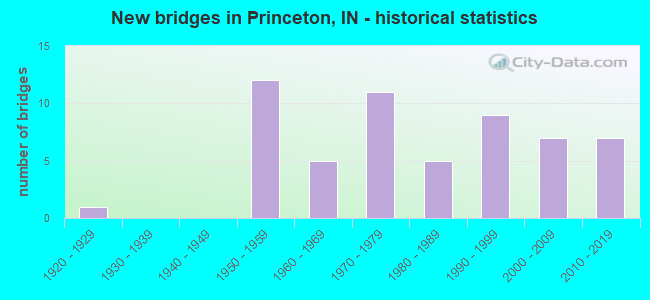
- New bridges - historical statistics
- 11920-1929
- 121950-1959
- 51960-1969
- 111970-1979
- 51980-1989
- 91990-1999
- 72000-2009
- 72010-2019
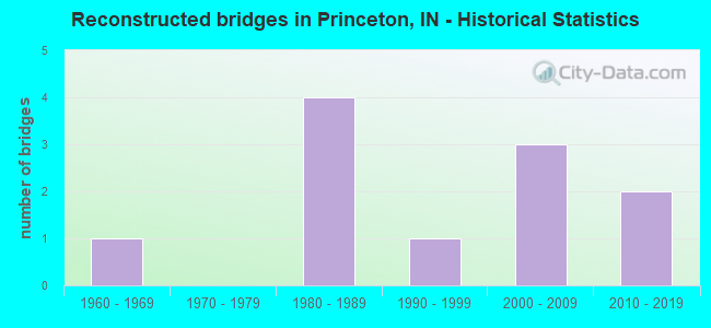
- Reconstructed bridges - Historical Statistics
- 11960-1969
- 01970-1979
- 41980-1989
- 11990-1999
- 32000-2009
- 22010-2019
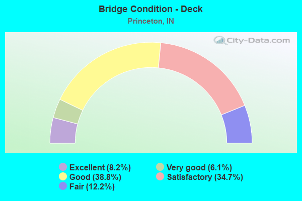
- Bridge Condition - Deck
- 8.2%Excellent
- 6.1%Very good
- 38.8%Good
- 34.7%Satisfactory
- 12.2%Fair
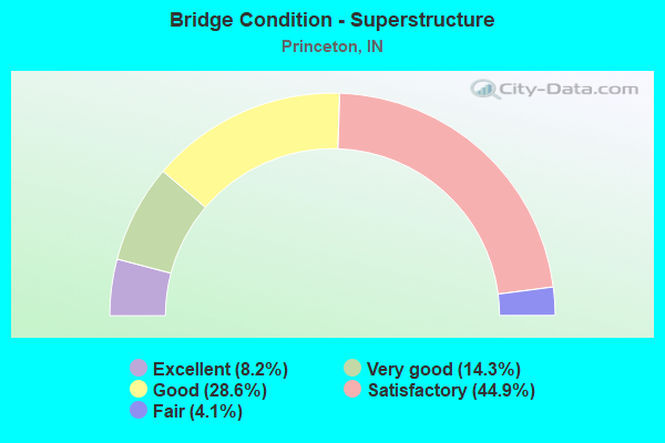
- Bridge Condition - Superstructure
- 8.2%Excellent
- 14.3%Very good
- 28.6%Good
- 44.9%Satisfactory
- 4.1%Fair
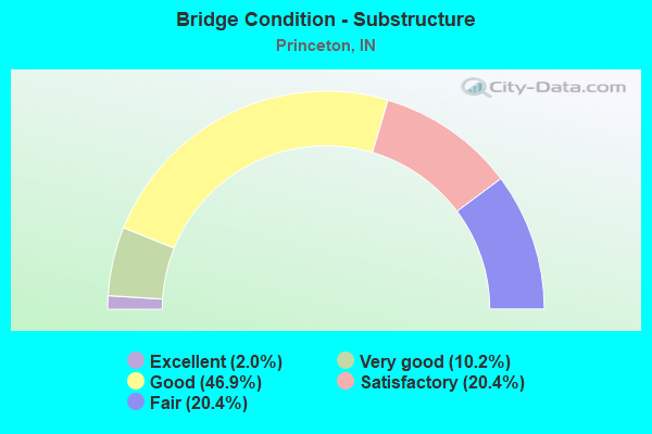
- Bridge Condition - Substructure
- 2.0%Excellent
- 10.2%Very good
- 46.9%Good
- 20.4%Satisfactory
- 20.4%Fair
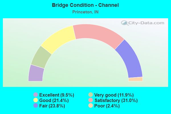
- Bridge Condition - Channel
- 9.5%Excellent
- 11.9%Very good
- 21.4%Good
- 31.0%Satisfactory
- 23.8%Fair
- 2.4%Poor
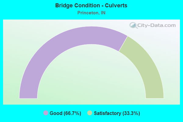
- Bridge Condition - Culverts
- 66.7%Good
- 33.3%Satisfactory
Find on map >> Show street view
Structure Number: 2600317, Location: 00.50 N OF CR 300 S (Lat: 38.319481, Lng: -87.598872), Route carried "on" structure: County highway 51, Year Built: 1984, Status: Open, Structure Length: 1.27m (4.17ft), Average Daily Traffic: 100 (year 2012), Truck Traffic: 3%, Average Future Daily Traffic: 145 (year 2032), Features Intersected: WOODS LATERAL, Facility Carried by Structure: CR 125 W
Minimum Vertical Clearance: 30+ m (98+ ft), Kilometerpoint: 0.000, Lanes on structure: 2, Owner: County Highway Agency, Approaching Roadway Width: 4.3m (14.1ft), Material/Design: Steel, Design/Construction: Stringer/Multi-beam, Number Of Spans In Main Unit: 1, Length of Maximum Span: 11.5m (37.7ft), Curb-To-Curb Width: 6.6m (21.7ft), Out-to-Out Width: 6.7m (22.0ft)
Condition: Deck: Satisfactory, Superstructure: Satisfactory, Substructure: Satisfactory, Channel: Fair, Operating Rating: 46.5 metric tons, Method Used To Determine Operating Rating: Load Factor (LF), Inventory Rating: 27.9 metric tons, Method Used To Determine Inventory Rating: Load Factor (LF), Structural Evaluation: Equal to present minimum criteria, Deck Geometry: Somewhat better than minimum adequacy, Waterway Adequacy: Somewhat better than minimum adequacy, Approach Roadway Alignment: Equal to present minimum criteria, Designated Inspection Frequency: Every 24 months, Inspection Date: April 2020, Deck Structure Type: Concrete Cast-file-Place, Wearing Surface/Protective System: Wearing Surface: Monolithic Concrete
Find on map >> Show street view
Structure Number: 2600321, Location: 00.80 N OF CR 250 S (Lat: 38.330500, Lng: -87.567206), Route carried "on" structure: City street , Year Built: 1999, Status: Open, Structure Length: 1.63m (5.35ft), Average Daily Traffic: 2,000 (year 2012), Truck Traffic: 6%, Average Future Daily Traffic: 3,200 (year 2032), Features Intersected: CLEAR FORK DITCH, Facility Carried by Structure: S OLD US 41
Minimum Vertical Clearance: 30+ m (98+ ft), Kilometerpoint: 0.000, Lanes on structure: 2, Owner: County Highway Agency, Approaching Roadway Width: 7.0m (23.0ft), Material/Design: Wood or Timber, Design/Construction: Slab, Number Of Spans In Main Unit: 3, Length of Maximum Span: 7.5m (24.6ft), Curb or Sidewalk Widths: Left: 0.2m (0.7ft), Right: 0.2m (0.7ft), Curb-To-Curb Width: 8.7m (28.5ft), Out-to-Out Width: 9.1m (29.9ft)
Condition: Deck: Good, Superstructure: Satisfactory, Substructure: Good, Channel: Good, Operating Rating: 61.0 metric tons, Method Used To Determine Operating Rating: Load and Resistance Factor (LRFR), Inventory Rating: 45.3 metric tons, Method Used To Determine Inventory Rating: Load and Resistance Factor (LRFR), Structural Evaluation: Equal to present minimum criteria, Deck Geometry: Somewhat better than minimum adequacy, Waterway Adequacy: Equal to present desirable criteria, Approach Roadway Alignment: Equal to present desirable criteria, Designated Inspection Frequency: Every 24 months, Inspection Date: April 2020, Deck Structure Type: Wood or Timber, Wearing Surface/Protective System: Wearing Surface: Bituminous
Find on map >> Show street view
Structure Number: 2600326, Location: 00.10 N OF GARFIELD AVE (Lat: 38.342283, Lng: -87.567333), Route carried "on" structure: City street , Year Built: 1993, Status: Open, Structure Length: 2.07m (6.79ft), Average Daily Traffic: 2,050 (year 2012), Truck Traffic: 5%, Average Future Daily Traffic: 3,075 (year 2032), Design Load: HS 20, Features Intersected: N&S RR, Facility Carried by Structure: MAIN ST
Minimum Vertical Clearance: 30+ m (98+ ft), Kilometerpoint: 0.000, Lanes on structure: 2, Owner: County Highway Agency, Approaching Roadway Width: 12.2m (40.0ft), Skew: 1 degrees, Material/Design: Prestressed concrete, Design/Construction: Box Beam or Girders - Multiple, Number Of Spans In Main Unit: 1, Length of Maximum Span: 19.8m (65.0ft), Curb-To-Curb Width: 12.2m (40.0ft), Out-to-Out Width: 13.1m (43.0ft)
Condition: Deck: Good, Superstructure: Good, Substructure: Good, Operating Rating: 32.7 metric tons, Method Used To Determine Operating Rating: Field evaluation and documented engineering judgment, Inventory Rating: 32.7 metric tons, Method Used To Determine Inventory Rating: Field evaluation and documented engineering judgment, Structural Evaluation: Better than present minimum criteria, Deck Geometry: Equal to present minimum criteria, Underclear: Equal to present minimum criteria, Approach Roadway Alignment: Equal to present desirable criteria, Designated Inspection Frequency: Every 24 months, Inspection Date: April 2020, Deck Structure Type: Concrete Cast-file-Place, Wearing Surface/Protective System: Wearing Surface: Monolithic Concrete, Deck Protection: Epoxy Coated Reinforcing
Find on map >> Show street view
Structure Number: 2600331, Location: 00.20 W OF SR 65 (Lat: 38.392219, Lng: -87.548722), Route carried "on" structure: County highway 65, Year Built: 2009, Status: Open, Structure Length: 6.61m (21.69ft), Average Daily Traffic: 130 (year 2012), Truck Traffic: 2%, Average Future Daily Traffic: 190 (year 2032), Design Load: HS 20, Features Intersected: PATOKA RIVER, Facility Carried by Structure: PETERSBURG RD
Minimum Vertical Clearance: 30+ m (98+ ft), Kilometerpoint: 0.000, Lanes on structure: 2, Owner: County Highway Agency, Approaching Roadway Width: 9.8m (32.2ft), Skew: 4 degrees, Material/Design: Prestressed concrete continuous, Design/Construction: Stringer/Multi-beam, Number Of Spans In Main Unit: 3, Length of Maximum Span: 26.2m (86.0ft), Curb-To-Curb Width: 9.8m (32.2ft), Out-to-Out Width: 10.7m (35.1ft)
Condition: Deck: Good, Superstructure: Very good, Substructure: Good, Channel: Good, Operating Rating: 82.3 metric tons, Method Used To Determine Operating Rating: Load and Resistance Factor (LRFR), Inventory Rating: 61.0 metric tons, Method Used To Determine Inventory Rating: Load and Resistance Factor (LRFR), Structural Evaluation: Better than present minimum criteria, Deck Geometry: Better than present minimum criteria, Waterway Adequacy: Superior to present desirable criteria, Approach Roadway Alignment: Equal to present minimum criteria, Designated Inspection Frequency: Every 24 months, Inspection Date: March 2020, Deck Structure Type: Concrete Cast-file-Place, Wearing Surface/Protective System: Wearing Surface: Monolithic Concrete, Deck Protection: Epoxy Coated Reinforcing
Find on map >> Show street view
Structure Number: 2600335, Location: 01.20 E OF US 41 (Lat: 38.304300, Lng: -87.545386), Route carried "on" structure: County highway , Year Built: 2010, Status: Open, Structure Length: 2.32m (7.61ft), Average Daily Traffic: 375 (year 2012), Truck Traffic: 3%, Average Future Daily Traffic: 475 (year 2032), Design Load: HS 20, Features Intersected: PIGEON CREEK, Facility Carried by Structure: CR 350 S
Minimum Vertical Clearance: 30+ m (98+ ft), Kilometerpoint: 0.000, Lanes on structure: 2, Owner: County Highway Agency, Approaching Roadway Width: 6.7m (22.0ft), Skew: 4 degrees, Material/Design: Prestressed concrete, Design/Construction: Box Beam or Girders - Multiple, Number Of Spans In Main Unit: 1, Length of Maximum Span: 21.9m (71.9ft), Curb-To-Curb Width: 7.2m (23.6ft), Out-to-Out Width: 7.4m (24.3ft)
Condition: Deck: Good, Superstructure: Satisfactory, Substructure: Good, Channel: Satisfactory, Operating Rating: 32.7 metric tons, Method Used To Determine Operating Rating: Field evaluation and documented engineering judgment, Inventory Rating: 32.7 metric tons, Method Used To Determine Inventory Rating: Field evaluation and documented engineering judgment, Structural Evaluation: Equal to present minimum criteria, Deck Geometry: Meets minimum limits, Waterway Adequacy: Better than present minimum criteria, Approach Roadway Alignment: Equal to present desirable criteria, Designated Inspection Frequency: Every 24 months, Inspection Date: March 2020, Deck Structure Type: Concrete Precast Panels, Wearing Surface/Protective System: Wearing Surface: Bituminous
Find on map >> Show street view
Structure Number: 2600342, Location: 00.50 N OF SR 64 (Lat: 38.363219, Lng: -87.659172), Route carried "on" structure: County highway 357, Year Built: 2012, Status: Open, Structure Length: 1.60m (5.25ft), Average Daily Traffic: 100 (year 2012), Truck Traffic: 5%, Average Future Daily Traffic: 155 (year 2032), Design Load: HL 93, Features Intersected: MCCARTY DITCH, Facility Carried by Structure: CR 500 W
Minimum Vertical Clearance: 30+ m (98+ ft), Kilometerpoint: 0.000, Lanes on structure: 2, Owner: County Highway Agency, Approaching Roadway Width: 6.1m (20.0ft), Material/Design: Prestressed concrete, Design/Construction: Box Beam or Girders - Single/Spread, Number Of Spans In Main Unit: 1, Length of Maximum Span: 15.2m (49.9ft), Curb-To-Curb Width: 9.8m (32.2ft), Out-to-Out Width: 10.7m (35.1ft)
Condition: Deck: Very good, Superstructure: Very good, Substructure: Good, Channel: Very good, Operating Rating: 61.6 metric tons, Method Used To Determine Operating Rating: Load and Resistance Factor (LRFR), Inventory Rating: 42.2 metric tons, Method Used To Determine Inventory Rating: Load and Resistance Factor (LRFR), Structural Evaluation: Better than present minimum criteria, Deck Geometry: Equal to present desirable criteria, Waterway Adequacy: Better than present minimum criteria, Approach Roadway Alignment: Equal to present desirable criteria, Designated Inspection Frequency: Every 24 months, Inspection Date: March 2020, Deck Structure Type: Concrete Cast-file-Place, Wearing Surface/Protective System: Wearing Surface: Monolithic Concrete, Deck Protection: Epoxy Coated Reinforcing
Find on map >> Show street view
Structure Number: 2600343, Location: 01.00 E OF MAIN STREET (Lat: 38.343950, Lng: -87.554108), Route carried "on" structure: County highway , Year Built: 2011, Status: Open, Structure Length: 1.07m (3.51ft), Average Daily Traffic: 200 (year 2012), Truck Traffic: 5%, Average Future Daily Traffic: 300 (year 2032), Features Intersected: OUTER OHIO DITCH, Facility Carried by Structure: E OHIO STREET
Minimum Vertical Clearance: 30+ m (98+ ft), Kilometerpoint: 0.000, Lanes on structure: 2, Owner: County Highway Agency, Approaching Roadway Width: 5.5m (18.0ft), Material/Design: Steel, Design/Construction: Stringer/Multi-beam, Number Of Spans In Main Unit: 1, Length of Maximum Span: 10.3m (33.8ft), Curb-To-Curb Width: 7.3m (24.0ft), Out-to-Out Width: 7.3m (24.0ft)
Condition: Deck: Good, Superstructure: Good, Substructure: Very good, Channel: Good, Operating Rating: 80.8 metric tons, Method Used To Determine Operating Rating: Load Factor (LF), Inventory Rating: 48.4 metric tons, Method Used To Determine Inventory Rating: Load Factor (LF), Structural Evaluation: Better than present minimum criteria, Deck Geometry: Somewhat better than minimum adequacy, Waterway Adequacy: Better than present minimum criteria, Approach Roadway Alignment: Equal to present desirable criteria, Designated Inspection Frequency: Every 24 months, Inspection Date: March 2020, Deck Structure Type: Concrete Cast-file-Place, Wearing Surface/Protective System: Wearing Surface: Bituminous, Deck Protection: Epoxy Coated Reinforcing
Find on map >> Show street view
Structure Number: 2600344, Location: 00.30 S OF SR 65 (Lat: 38.350561, Lng: -87.587539), Route carried "on" structure: City street 2, Year Built: 2015, Status: Open, Structure Length: 0.91m (2.99ft), Average Daily Traffic: 2,560 (year 2014), Truck Traffic: 7%, Average Future Daily Traffic: 3,140 (year 2034), Features Intersected: RICHLAND CREEK
Minimum Vertical Clearance: 30+ m (98+ ft), Kilometerpoint: 0.000, Lanes on structure: 2, Owner: County Highway Agency, Approaching Roadway Width: 8.5m (27.9ft), Material/Design: Concrete, Design/Construction: Culvert, Number Of Spans In Main Unit: 1, Length of Maximum Span: 8.5m (27.9ft), Curb-To-Curb Width: 8.5m (27.9ft), Out-to-Out Width: 8.5m (27.9ft)
Condition: Channel: Satisfactory, Culverts: Good, Operating Rating: 32.7 metric tons, Method Used To Determine Operating Rating: Field evaluation and documented engineering judgment, Inventory Rating: 32.7 metric tons, Method Used To Determine Inventory Rating: Field evaluation and documented engineering judgment, Structural Evaluation: Better than present minimum criteria, Deck Geometry: Meets minimum limits, Waterway Adequacy: Equal to present desirable criteria, Approach Roadway Alignment: Equal to present desirable criteria, Designated Inspection Frequency: Every 24 months, Inspection Date: March 2020
Find on map >> Show street view
Structure Number: 2600355, Location: 01.00 S OF CR E 50 N (Lat: 38.355781, Lng: -87.714972), Route carried "on" structure: County highway , Year Built: 2015, Status: Open, Structure Length: 1.65m (5.41ft), Average Daily Traffic: 60 (year 2012), Truck Traffic: 5%, Average Future Daily Traffic: 125 (year 2032), Features Intersected: MCCARTY DITCH, Facility Carried by Structure: CR 800 W
Minimum Vertical Clearance: 30+ m (98+ ft), Kilometerpoint: 0.000, Lanes on structure: 2, Owner: County Highway Agency, Approaching Roadway Width: 7.9m (25.9ft), Material/Design: Steel, Design/Construction: Stringer/Multi-beam, Number Of Spans In Main Unit: 1, Length of Maximum Span: 16.2m (53.1ft), Curb-To-Curb Width: 7.2m (23.6ft), Out-to-Out Width: 7.3m (24.0ft)
Condition: Deck: Good, Superstructure: Very good, Substructure: Good, Channel: Good, Operating Rating: 69.9 metric tons, Method Used To Determine Operating Rating: Load Factor (LF), Inventory Rating: 41.9 metric tons, Method Used To Determine Inventory Rating: Load Factor (LF), Structural Evaluation: Better than present minimum criteria, Deck Geometry: Somewhat better than minimum adequacy, Waterway Adequacy: Equal to present minimum criteria, Approach Roadway Alignment: High priority of corrective action, Designated Inspection Frequency: Every 24 months, Inspection Date: March 2020, Deck Structure Type: Concrete Cast-file-Place, Wearing Surface/Protective System: Wearing Surface: Monolithic Concrete
Find on map >> Show street view
Structure Number: 260036, Location: 00.20 N OF CR 800 S (Lat: 38.244131, Lng: -87.642753), Route carried "on" structure: County highway , Year Built: 2018, Status: Open, Structure Length: 0.85m (2.79ft), Average Daily Traffic: 525 (year 2013), Truck Traffic: 13%, Average Future Daily Traffic: 730 (year 2033), Features Intersected: BRANCH OF MCGARY DITCH, Facility Carried by Structure: CR 400 W
Minimum Vertical Clearance: 30+ m (98+ ft), Kilometerpoint: 0.000, Lanes on structure: 2, Owner: County Highway Agency, Approaching Roadway Width: 6.7m (22.0ft), Skew: 2 degrees, Material/Design: Steel, Design/Construction: Stringer/Multi-beam, Number Of Spans In Main Unit: 1, Length of Maximum Span: 8.2m (26.9ft), Curb-To-Curb Width: 7.9m (25.9ft), Out-to-Out Width: 7.9m (25.9ft)
Condition: Deck: Very good, Superstructure: Very good, Substructure: Excellent, Channel: Very good, Operating Rating: 62.6 metric tons, Method Used To Determine Operating Rating: Load Factor (LF), Inventory Rating: 37.5 metric tons, Method Used To Determine Inventory Rating: Load Factor (LF), Structural Evaluation: Equal to present desirable criteria, Deck Geometry: Somewhat better than minimum adequacy, Waterway Adequacy: Better than present minimum criteria, Approach Roadway Alignment: Equal to present desirable criteria, Designated Inspection Frequency: Every 24 months, Inspection Date: March 2020, Deck Structure Type: Concrete Cast-file-Place, Wearing Surface/Protective System: Wearing Surface: Monolithic Concrete
Find on map >> Show street view
Structure Number: 2600362, Location: 00.20 E OF US 41 (Lat: 38.348089, Lng: -87.594781), Route carried "on" structure: City street 329, Year Built: 1970, Status: Open, Structure Length: 0.94m (3.08ft), Average Daily Traffic: 1,030 (year 2012), Truck Traffic: 5%, Average Future Daily Traffic: 1,420 (year 2032), Features Intersected: BRANCH RICHLAND CR, Facility Carried by Structure: CR 50 S
Minimum Vertical Clearance: 30+ m (98+ ft), Kilometerpoint: 0.000, Lanes on structure: 2, Owner: County Highway Agency, Approaching Roadway Width: 7.2m (23.6ft), Material/Design: Steel, Design/Construction: Stringer/Multi-beam, Number Of Spans In Main Unit: 1, Length of Maximum Span: 8.4m (27.6ft), Curb-To-Curb Width: 8.4m (27.6ft), Out-to-Out Width: 8.5m (27.9ft)
Condition: Deck: Fair, Superstructure: Satisfactory, Substructure: Satisfactory, Channel: Fair, Operating Rating: 46.4 metric tons, Method Used To Determine Operating Rating: Load Factor (LF), Inventory Rating: 27.8 metric tons, Method Used To Determine Inventory Rating: Load Factor (LF), Structural Evaluation: Equal to present minimum criteria, Deck Geometry: Meets minimum limits, Waterway Adequacy: Better than present minimum criteria, Approach Roadway Alignment: Equal to present desirable criteria, Designated Inspection Frequency: Every 24 months, Inspection Date: April 2020, Deck Structure Type: Concrete Cast-file-Place, Wearing Surface/Protective System: Wearing Surface: Bituminous
Find on map >> Show street view
Structure Number: 2600364, Location: 00.50 S OF SR 64 (Lat: 38.349900, Lng: -87.640889), Route carried "on" structure: County highway 65, Year Built: 2019, Status: Open, Structure Length: 2.74m (8.99ft), Average Daily Traffic: 250 (year 2020), Truck Traffic: 3%, Average Future Daily Traffic: 310 (year 2040), Design Load: HL 93, Features Intersected: BROWN DITCH, Facility Carried by Structure: CR 400 W
Minimum Vertical Clearance: 30+ m (98+ ft), Kilometerpoint: 0.000, Lanes on structure: 2, Owner: County Highway Agency, Approaching Roadway Width: 5.5m (18.0ft), Material/Design: Concrete continuous, Design/Construction: Slab, Number Of Spans In Main Unit: 3, Length of Maximum Span: 9.1m (29.9ft), Curb-To-Curb Width: 7.8m (25.6ft), Out-to-Out Width: 7.9m (25.9ft)
Condition: Deck: Very good, Superstructure: Very good, Substructure: Very good, Channel: Very good, Operating Rating: 44.7 metric tons, Method Used To Determine Operating Rating: Load and Resistance Factor (LRFR), Inventory Rating: 33.2 metric tons, Method Used To Determine Inventory Rating: Load and Resistance Factor (LRFR), Structural Evaluation: Equal to present desirable criteria, Deck Geometry: Somewhat better than minimum adequacy, Waterway Adequacy: Equal to present minimum criteria, Approach Roadway Alignment: Equal to present desirable criteria, Designated Inspection Frequency: Every 24 months, Inspection Date: April 2020, Deck Structure Type: Concrete Cast-file-Place, Wearing Surface/Protective System: Wearing Surface: Monolithic Concrete
Find on map >> Show street view
Structure Number: 1446, Location: 03.60 S SR 64 (Lat: 38.312689, Lng: -87.568658), Route carried "under" structure: US 41, Year Built: 2003, Structure Length: 0. m, Average Daily Traffic: 11,127 (year 2004), Truck Traffic: 12%, Features Intersected: US-41 SBL, Facility Carried by Structure: KINGS MINE ROAD
Minimum Vertical Clearance: 5.82m (19.09ft), Kilometerpoint: 16.802, Lanes on structure: 3, Lanes under structure: 5, Material/Design: Prestressed concrete continuous, Design/Construction: Tee Beam, Length of Maximum Span: 30.0m (98.4ft)
Find on map >> Show street view
Structure Number: 1446, Location: 03.60 S SR 64 (Lat: 38.312689, Lng: -87.568658), Route carried "under" structure: US 41, Year Built: 2003, Structure Length: 0. m, Average Daily Traffic: 11,127 (year 2004), Truck Traffic: 12%, Features Intersected: US-41 NBL, Facility Carried by Structure: KINGS MINE ROAD
Minimum Vertical Clearance: 5.82m (19.09ft), Kilometerpoint: 16.802, Lanes on structure: 3, Lanes under structure: 5, Material/Design: Prestressed concrete continuous, Design/Construction: Tee Beam, Length of Maximum Span: 30.0m (98.4ft)
Find on map >> Show street view
Structure Number: 2287, Location: 01.70 W SR 65 (Lat: 38.355511, Lng: -87.598397), Route carried "under" structure: US 41, Year Built: 1959, Structure Length: 0. m, Average Daily Traffic: 8,208 (year 2014), Truck Traffic: 20%, Features Intersected: US 41 NB, Facility Carried by Structure: SR 64/SR 65
Minimum Vertical Clearance: 5.18m (16.99ft), Kilometerpoint: 22.402, Lanes on structure: 6, Lanes under structure: 3, Material/Design: Steel continuous, Design/Construction: Stringer/Multi-beam, Length of Maximum Span: 22.2m (72.8ft)
Find on map >> Show street view
Structure Number: 2287, Location: 01.70 W SR 65 (Lat: 38.355511, Lng: -87.598397), Route carried "under" structure: US 41, Year Built: 1959, Structure Length: 0. m, Average Daily Traffic: 8,208 (year 2014), Truck Traffic: 20%, Features Intersected: US 41 SB, Facility Carried by Structure: SR 64/SR 65
Minimum Vertical Clearance: 5.18m (16.99ft), Kilometerpoint: 22.402, Lanes on structure: 6, Lanes under structure: 3, Material/Design: Steel continuous, Design/Construction: Stringer/Multi-beam, Length of Maximum Span: 22.2m (72.8ft)
Find on map >> Show street view
Structure Number: 2600313, Location: 00.10 N SR 64 (Lat: 38.358300, Lng: -87.579619), Route carried "under" structure: City street , Year Built: 1974, Structure Length: 0. m, Average Daily Traffic: 20 (year 2010), Truck Traffic: 5%, Features Intersected: BROWN STREET, Facility Carried by Structure: BRUMFIELD AVE
Minimum Vertical Clearance: 7.01m (23.00ft), Kilometerpoint: 0.000, Lanes on structure: 2, Lanes under structure: 2, Material/Design: Prestressed concrete continuous, Design/Construction: Stringer/Multi-beam, Length of Maximum Span: 21.9m (71.9ft)