Bridge Statistics for Pueblo, Colorado (CO)
Condition, Traffic, Stress, Structural Evaluation, Project Costs
- National Bridge Inventory (NBI) Statistics
- 160Number of bridges
- 2,372ft / 723mTotal length
- $76,092,000Total costs
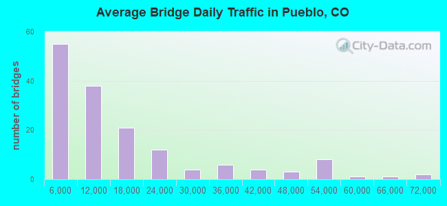
- 2,235,983Total average daily traffic
- 152,753Total average daily truck traffic
- National Bridge Inventory (NBI) Registered Bridges for Pueblo
- No street view available for this location
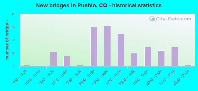
- New bridges - historical statistics
- 11900-1909
- 111920-1929
- 81930-1939
- 11940-1949
- 301950-1959
- 311960-1969
- 251970-1979
- 101980-1989
- 151990-1999
- 122000-2009
- 152010-2019
- 12020-2022
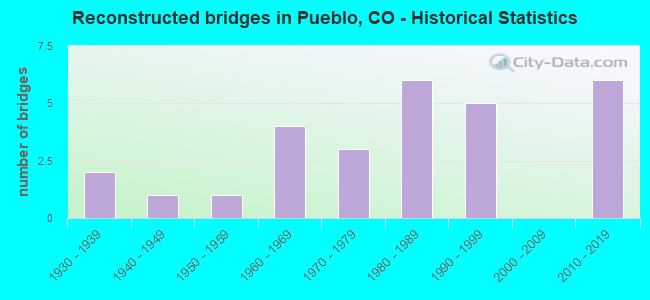
- Reconstructed bridges - Historical Statistics
- 21930-1939
- 11940-1949
- 11950-1959
- 41960-1969
- 31970-1979
- 61980-1989
- 51990-1999
- 02000-2009
- 62010-2019
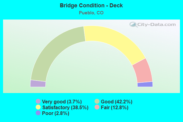
- Bridge Condition - Deck
- 3.7%Very good
- 42.2%Good
- 38.5%Satisfactory
- 12.8%Fair
- 2.8%Poor
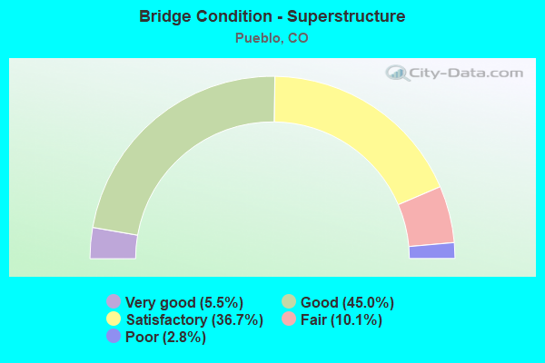
- Bridge Condition - Superstructure
- 5.5%Very good
- 45.0%Good
- 36.7%Satisfactory
- 10.1%Fair
- 2.8%Poor
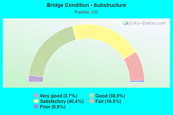
- Bridge Condition - Substructure
- 3.7%Very good
- 38.5%Good
- 40.4%Satisfactory
- 16.5%Fair
- 0.9%Poor
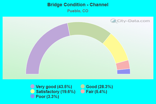
- Bridge Condition - Channel
- 43.5%Very good
- 28.3%Good
- 19.6%Satisfactory
- 5.4%Fair
- 3.3%Poor
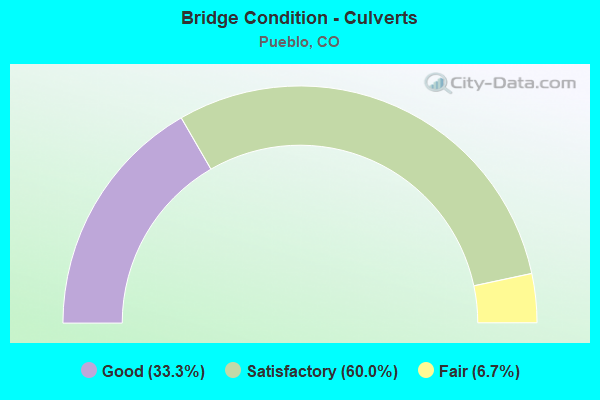
- Bridge Condition - Culverts
- 33.3%Good
- 60.0%Satisfactory
- 6.7%Fair
Find on map >> Show street view
Structure Number: K-18-AB, Location: 2.8 MI N OF JCT US 50 W S (Lat: 38.347717, Lng: -104.619844), Route carried "on" structure: Interstate 25A, Year Built: 1928, Year Reconstructed: 1941, Status: Open, Structure Length: 0.74m (2.43ft), Average Daily Traffic: 35,000 (year 2020), Truck Traffic: 10%, Average Future Daily Traffic: 46,900 (year 2040), Design Load: H 15, Features Intersected: DRAW, Facility Carried by Structure: I 25 ML
Minimum Vertical Clearance: 30+ m (98+ ft), Kilometerpoint: 167.645, Lanes on structure: 4, Base Highway Network: Yes, Owner: State Highway Agency, Approaching Roadway Width: 23.2m (76.1ft), Skew: 33 degrees, Material/Design: Concrete, Design/Construction: Culvert, Number Of Spans In Main Unit: 2, Length of Maximum Span: 3.5m (11.5ft), Out-to-Out Width: 34.0m (111.5ft)
Condition: Channel: Satisfactory, Culverts: Satisfactory, Operating Rating: 36.3 metric tons, Method Used To Determine Operating Rating: Field evaluation and documented engineering judgment, Inventory Rating: 32.7 metric tons, Method Used To Determine Inventory Rating: Field evaluation and documented engineering judgment, Structural Evaluation: Equal to present minimum criteria, Waterway Adequacy: Equal to present desirable criteria, Approach Roadway Alignment: Equal to present desirable criteria, Designated Inspection Frequency: Every 24 months, Inspection Date: April 2020
Find on map >> Show street view
Structure Number: K-18-AD, Location: IN PUEBLO (Lat: 38.271725, Lng: -104.565878), Route carried "on" structure: State highway 96A, Year Built: 1936, Year Reconstructed: 1955, Status: Temporarily open, Structure Length: 2.10m (6.89ft), Average Daily Traffic: 6,600 (year 2020), Truck Traffic: 5%, Average Future Daily Traffic: 6,864 (year 2040), Design Load: H 15, Features Intersected: BIG DRY CREEK, Facility Carried by Structure: SH 96 ML
Minimum Vertical Clearance: 30.45m (99.90ft), Kilometerpoint: 92.634, Lanes on structure: 4, Base Highway Network: Yes, Owner: State Highway Agency, Approaching Roadway Width: 21.3m (69.9ft), Skew: 3 degrees, Material/Design: Wood or Timber, Design/Construction: Stringer/Multi-beam, Number Of Spans In Main Unit: 3, Length of Maximum Span: 6.9m (22.6ft), Curb-To-Curb Width: 21.3m (69.9ft), Out-to-Out Width: 23.2m (76.1ft)
Condition: Deck: Satisfactory, Superstructure: Poor, Substructure: Satisfactory, Channel: Very good, Operating Rating: 38.5 metric tons, Method Used To Determine Operating Rating: Allowable Stress (AS), Inventory Rating: 27.0 metric tons, Method Used To Determine Inventory Rating: Load Factor (LF), Structural Evaluation: Meets minimum limits, Deck Geometry: Superior to present desirable criteria, Waterway Adequacy: Equal to present desirable criteria, Approach Roadway Alignment: Equal to present desirable criteria, Designated Inspection Frequency: Every 24 months, Inspection Date: January 2021, Deck Structure Type: Wood or Timber, Wearing Surface/Protective System: Wearing Surface: Bituminous
Find on map >> Show street view
Structure Number: K-18-AE, Location: 1.4 MI E OF JCT SH 45 (Lat: 38.259272, Lng: -104.636308), Route carried "on" structure: State highway 96A, Year Built: 1936, Status: Open, Structure Length: 1.16m (3.81ft), Average Daily Traffic: 17,000 (year 2020), Truck Traffic: 2%, Average Future Daily Traffic: 18,190 (year 2040), Design Load: H 15, Features Intersected: BESSEMER DITCH, Facility Carried by Structure: SH 96 ML
Minimum Vertical Clearance: 30.45m (99.90ft), Kilometerpoint: 85.958, Lanes on structure: 4, Base Highway Network: Yes, Owner: State Highway Agency, Approaching Roadway Width: 18.0m (59.1ft), Material/Design: Steel, Design/Construction: Stringer/Multi-beam, Number Of Spans In Main Unit: 1, Length of Maximum Span: 10.7m (35.1ft), Curb or Sidewalk Widths: Left: 3.7m (12.1ft), Right: 3.7m (12.1ft), Curb-To-Curb Width: 18.0m (59.1ft), Out-to-Out Width: 25.9m (85.0ft)
Condition: Deck: Satisfactory, Superstructure: Satisfactory, Substructure: Satisfactory, Channel: Satisfactory, Operating Rating: 34.9 metric tons, Method Used To Determine Operating Rating: Load Factor (LF), Inventory Rating: 20.9 metric tons, Method Used To Determine Inventory Rating: Load Factor (LF), Structural Evaluation: Somewhat better than minimum adequacy, Deck Geometry: Somewhat better than minimum adequacy, Waterway Adequacy: Equal to present desirable criteria, Approach Roadway Alignment: Equal to present desirable criteria, Length Of Structure Improvement: 1.16m (3.81ft), Designated Inspection Frequency: Every 24 months, Inspection Date: January 2021, Bridge Improvement Cost: $86,000, Roadway Improvement Cost: $9,000, Total Project Cost: $130,000, Deck Structure Type: Concrete Cast-file-Place, Wearing Surface/Protective System: Wearing Surface: Bituminous
Find on map >> Show street view
Structure Number: K-18-AI, Location: 22.5 MI E OF CUSTER-PUEBL (Lat: 38.258739, Lng: -104.679750), Route carried "on" structure: State highway 96A, Year Built: 1950, Year Reconstructed: 1980, Status: Open, Structure Length: 1.04m (3.41ft), Average Daily Traffic: 5,500 (year 2020), Truck Traffic: 4%, Average Future Daily Traffic: 6,215 (year 2040), Design Load: H 20, Features Intersected: BESSEMER DITCH, Facility Carried by Structure: SH 96 ML
Minimum Vertical Clearance: 30+ m (98+ ft), Kilometerpoint: 82.130, Lanes on structure: 4, Base Highway Network: Yes, Owner: State Highway Agency, Approaching Roadway Width: 20.1m (65.9ft), Skew: 5 degrees, Material/Design: Concrete, Design/Construction: Slab, Number Of Spans In Main Unit: 1, Length of Maximum Span: 9.5m (31.2ft), Curb-To-Curb Width: 20.1m (65.9ft), Out-to-Out Width: 30.9m (101.4ft)
Condition: Deck: Good, Superstructure: Good, Substructure: Good, Channel: Very good, Operating Rating: 20.1 metric tons, Method Used To Determine Operating Rating: Load Factor (LF), Inventory Rating: 12.1 metric tons, Method Used To Determine Inventory Rating: Load Factor (LF), Structural Evaluation: High priority of corrective action, Deck Geometry: Better than present minimum criteria, Waterway Adequacy: Equal to present desirable criteria, Approach Roadway Alignment: Equal to present desirable criteria, Designated Inspection Frequency: Every 24 months, Inspection Date: January 2021, Deck Structure Type: Concrete Cast-file-Place
Find on map >> Show street view
Structure Number: K-18-AJ, Location: IN PUEBLO (Lat: 38.254564, Lng: -104.608119), Route carried "on" structure: Interstate 25A, Year Built: 1958, Status: Open, Structure Length: 10.20m (33.46ft), Average Daily Traffic: 51,000 (year 2020), Truck Traffic: 6%, Average Future Daily Traffic: 60,180 (year 2040), Design Load: HS 20, Features Intersected: ARKANSAS RIVER, Facility Carried by Structure: I 25 ML
Minimum Vertical Clearance: 30+ m (98+ ft), Kilometerpoint: 157.024, Lanes on structure: 5, Base Highway Network: Yes, Owner: State Highway Agency, Approaching Roadway Width: 25.6m (84.0ft), Skew: 20 degrees, Material/Design: Steel continuous, Design/Construction: Girder and Floorbeam System, Number Of Spans In Main Unit: 2, Length of Maximum Span: 50.3m (165.0ft), Curb-To-Curb Width: 24.4m (80.1ft), Out-to-Out Width: 26.8m (87.9ft)
Condition: Deck: Fair, Superstructure: Fair, Substructure: Satisfactory, Channel: Very good, Operating Rating: 33.1 metric tons, Method Used To Determine Operating Rating: Load Factor (LF), Inventory Rating: 19.9 metric tons, Method Used To Determine Inventory Rating: Load Factor (LF), Structural Evaluation: Somewhat better than minimum adequacy, Deck Geometry: Equal to present minimum criteria, Waterway Adequacy: Superior to present desirable criteria, Approach Roadway Alignment: Equal to present desirable criteria, Designated Inspection Frequency: Every 24 months, Inspection Date: December 2020, Deck Structure Type: Concrete Cast-file-Place, Wearing Surface/Protective System: Wearing Surface: Bituminous
Find on map >> Show street view
Structure Number: K-18-AX, Location: IN PUEBLO I25/Santa Fe (Lat: 38.255789, Lng: -104.607031), Route carried "on" structure: Interstate 25A, Year Built: 1958, Year Reconstructed: 2016, Status: Open, Structure Length: 7.30m (23.95ft), Average Daily Traffic: 51,000 (year 2020), Truck Traffic: 6%, Average Future Daily Traffic: 60,180 (year 2040), Design Load: HL 93, Features Intersected: US 50 BUS. RTE., Facility Carried by Structure: I 25 ML
Minimum Vertical Clearance: 30+ m (98+ ft), Kilometerpoint: 157.191, Lanes on structure: 5, Lanes under structure: 4, Base Highway Network: Yes, Owner: State Highway Agency, Approaching Roadway Width: 28.0m (91.9ft), Skew: 35 degrees, Material/Design: Steel continuous, Design/Construction: Stringer/Multi-beam, Number Of Spans In Main Unit: 4, Length of Maximum Span: 20.1m (65.9ft), Curb or Sidewalk Widths: Left: 0.6m (2.0ft), Right: 0.6m (2.0ft), Curb-To-Curb Width: 28.0m (91.9ft), Out-to-Out Width: 29.9m (98.1ft)
Condition: Deck: Fair, Superstructure: Satisfactory, Substructure: Fair, Operating Rating: 47.0 metric tons, Method Used To Determine Operating Rating: Load and Resistance Factor Rating (LRFR) rating reported by rating factor(RF) method using HL-93 loadings, Inventory Rating: 36.3 metric tons, Method Used To Determine Inventory Rating: Load and Resistance Factor Rating (LRFR) rating reported by rating factor(RF) method using HL-93 loadings, Structural Evaluation: Somewhat better than minimum adequacy, Deck Geometry: Superior to present desirable criteria, Underclear: Meets minimum limits, Approach Roadway Alignment: Equal to present desirable criteria, Length Of Structure Improvement: 7.32m (24.02ft), Designated Inspection Frequency: Every 24 months, Inspection Date: April 2020, Bridge Improvement Cost: $587,000, Roadway Improvement Cost: $59,000, Total Project Cost: $881,000, Deck Structure Type: Concrete Cast-file-Place, Wearing Surface/Protective System: Wearing Surface: Bituminous, Membrane: Built-up
Find on map >> Show street view
Structure Number: K-18-BM, Location: 1.1 MI N OF JCT US 50B (Lat: 38.260764, Lng: -104.496719), Route carried "on" structure: County highway , Year Built: 1963, Status: Open, Structure Length: 1.46m (4.79ft), Average Daily Traffic: 3,700 (year 2018), Truck Traffic: 4%, Average Future Daily Traffic: 5,143 (year 2038), Design Load: HS 20, Features Intersected: ARKANSAS RIVER OVFLW, Facility Carried by Structure: BAXTER RD
Minimum Vertical Clearance: 30.45m (99.90ft), Kilometerpoint: 1.761, Lanes on structure: 2, Owner: County Highway Agency, Approaching Roadway Width: 7.6m (24.9ft), Material/Design: Wood or Timber, Design/Construction: Stringer/Multi-beam, Number Of Spans In Main Unit: 2, Length of Maximum Span: 7.0m (23.0ft), Curb-To-Curb Width: 9.8m (32.2ft), Out-to-Out Width: 10.1m (33.1ft)
Condition: Deck: Satisfactory, Superstructure: Fair, Substructure: Fair, Channel: Satisfactory, Operating Rating: 29.5 metric tons, Method Used To Determine Operating Rating: Allowable Stress (AS), Inventory Rating: 20.9 metric tons, Method Used To Determine Inventory Rating: Allowable Stress (AS), Structural Evaluation: Somewhat better than minimum adequacy, Deck Geometry: Meets minimum limits, Waterway Adequacy: Equal to present minimum criteria, Approach Roadway Alignment: Equal to present desirable criteria, Designated Inspection Frequency: Every 24 months, Inspection Date: December 2020, Deck Structure Type: Wood or Timber, Wearing Surface/Protective System: Wearing Surface: Bituminous
Find on map >> Show street view
Structure Number: K-18-BN, Location: 1 MI S OF JCT US 50 (Lat: 38.257717, Lng: -104.496628), Route carried "on" structure: State highway , Year Built: 1963, Status: Open, Structure Length: 12.82m (42.06ft), Average Daily Traffic: 3,700 (year 2018), Truck Traffic: 4%, Average Future Daily Traffic: 5,143 (year 2038), Design Load: HS 20, Features Intersected: ARKANSAS RIVER, Facility Carried by Structure: BAXTER RD.
Minimum Vertical Clearance: 30+ m (98+ ft), Kilometerpoint: 1.427, Lanes on structure: 2, Owner: County Highway Agency, Approaching Roadway Width: 7.9m (25.9ft), Material/Design: Steel continuous, Design/Construction: Stringer/Multi-beam, Number Of Spans In Main Unit: 6, Length of Maximum Span: 23.9m (78.4ft), Curb or Sidewalk Widths: Left: 0.5m (1.6ft), Right: 0.5m (1.6ft), Curb-To-Curb Width: 9.1m (29.9ft), Out-to-Out Width: 10.4m (34.1ft)
Condition: Deck: Satisfactory, Superstructure: Satisfactory, Substructure: Fair, Channel: Fair, Operating Rating: 43.3 metric tons, Method Used To Determine Operating Rating: Load Factor (LF), Inventory Rating: 25.9 metric tons, Method Used To Determine Inventory Rating: Load Factor (LF), Structural Evaluation: Somewhat better than minimum adequacy, Deck Geometry: Meets minimum limits, Waterway Adequacy: Equal to present desirable criteria, Approach Roadway Alignment: Equal to present desirable criteria, Designated Inspection Frequency: Every 24 months, Inspection Date: November 2020, Deck Structure Type: Concrete Cast-file-Place, Wearing Surface/Protective System: Wearing Surface: Monolithic Concrete
Find on map >> Show street view
Structure Number: K-18-BT, Location: IN PUEBLO (Lat: 38.270706, Lng: -104.602333), Route carried "on" structure: State highway 96A, Year Built: 1954, Status: Open, Structure Length: 18.63m (61.12ft), Average Daily Traffic: 15,000 (year 2020), Truck Traffic: 3%, Average Future Daily Traffic: 15,300 (year 2040), Design Load: HS 20, Features Intersected: UP RR, FOUNTAIN CRK, Facility Carried by Structure: SH 96 ML
Minimum Vertical Clearance: 16.93m (55.54ft), Kilometerpoint: 89.436, Lanes on structure: 4, Base Highway Network: Yes, Owner: State Highway Agency, Approaching Roadway Width: 18.3m (60.0ft), Skew: 1 degrees, Material/Design: Steel continuous, Design/Construction: Stringer/Multi-beam, Number Of Spans In Main Unit: 10, Length of Maximum Span: 24.4m (80.1ft), Curb or Sidewalk Widths: Left: 1.5m (4.9ft), Right: 1.5m (4.9ft), Curb-To-Curb Width: 13.4m (44.0ft), Out-to-Out Width: 16.5m (54.1ft)
Condition: Deck: Poor, Superstructure: Poor, Substructure: Fair, Channel: Very good, Operating Rating: 42.5 metric tons, Method Used To Determine Operating Rating: Load Factor (LF), Inventory Rating: 25.4 metric tons, Method Used To Determine Inventory Rating: Load Factor (LF), Structural Evaluation: Meets minimum limits, Deck Geometry: High priority of replacement, Underclear: Equal to present minimum criteria, Waterway Adequacy: Equal to present desirable criteria, Approach Roadway Alignment: Equal to present desirable criteria, Length Of Structure Improvement: 18.63m (61.12ft), Designated Inspection Frequency: Every 24 months, Inspection Date: December 2020, Bridge Improvement Cost: $1,227,000, Roadway Improvement Cost: $123,000, Total Project Cost: $1,841,000, Deck Structure Type: Concrete Cast-file-Place, Wearing Surface/Protective System: Wearing Surface: Bituminous, Membrane: Other
Find on map >> Show street view
Structure Number: K-18-BY, Location: IN PUEBLO, NEAR E EDGE (Lat: 38.280450, Lng: -104.568228), Route carried "on" structure: US 50B, Year Built: 1958, Status: Open, Structure Length: 3.79m (12.43ft), Average Daily Traffic: 3,850 (year 2020), Truck Traffic: 9%, Average Future Daily Traffic: 4,043 (year 2040), Design Load: HS 20+Mod, Features Intersected: DRY CREEK, Facility Carried by Structure: US 50 ML WBND
Minimum Vertical Clearance: 30.45m (99.90ft), Kilometerpoint: 4.004, Lanes on structure: 2, Base Highway Network: Yes, Owner: State Highway Agency, Approaching Roadway Width: 11.6m (38.1ft), Skew: 12 degrees, Material/Design: Concrete, Design/Construction: Tee Beam, Number Of Spans In Main Unit: 4, Length of Maximum Span: 9.1m (29.9ft), Curb-To-Curb Width: 9.1m (29.9ft), Out-to-Out Width: 10.4m (34.1ft)
Condition: Deck: Fair, Superstructure: Fair, Substructure: Fair, Channel: Poor, Operating Rating: 70.7 metric tons, Method Used To Determine Operating Rating: Load Factor (LF), Inventory Rating: 42.4 metric tons, Method Used To Determine Inventory Rating: Load Factor (LF), Structural Evaluation: Somewhat better than minimum adequacy, Deck Geometry: High priority of replacement, Waterway Adequacy: Superior to present desirable criteria, Approach Roadway Alignment: Equal to present desirable criteria, Length Of Structure Improvement: 3.81m (12.50ft), Designated Inspection Frequency: Every 24 months, Inspection Date: June 2020, Bridge Improvement Cost: $445,000, Roadway Improvement Cost: $44,000, Total Project Cost: $489,000 ( Estimate for 2018), Deck Structure Type: Concrete Cast-file-Place, Wearing Surface/Protective System: Wearing Surface: Bituminous
Find on map >> Show street view
Structure Number: K-18-BZ, Location: IN PUEBLO, NEAR E EDGE (Lat: 38.280297, Lng: -104.568267), Route carried "on" structure: US 50B, Year Built: 1958, Status: Open, Structure Length: 3.79m (12.43ft), Average Daily Traffic: 3,850 (year 2020), Truck Traffic: 9%, Average Future Daily Traffic: 4,043 (year 2040), Design Load: HS 20+Mod, Features Intersected: DRY CREEK, Facility Carried by Structure: US 50 ML EBND
Minimum Vertical Clearance: 30.45m (99.90ft), Kilometerpoint: 4.010, Lanes on structure: 2, Base Highway Network: Yes, Owner: State Highway Agency, Approaching Roadway Width: 11.6m (38.1ft), Skew: 12 degrees, Material/Design: Concrete, Design/Construction: Tee Beam, Number Of Spans In Main Unit: 4, Length of Maximum Span: 9.1m (29.9ft), Curb-To-Curb Width: 9.1m (29.9ft), Out-to-Out Width: 10.4m (34.1ft)
Condition: Deck: Satisfactory, Superstructure: Satisfactory, Substructure: Fair, Channel: Poor, Operating Rating: 69.5 metric tons, Method Used To Determine Operating Rating: Load Factor (LF), Inventory Rating: 41.5 metric tons, Method Used To Determine Inventory Rating: Load Factor (LF), Structural Evaluation: Somewhat better than minimum adequacy, Deck Geometry: High priority of replacement, Waterway Adequacy: Equal to present desirable criteria, Approach Roadway Alignment: Equal to present desirable criteria, Length Of Structure Improvement: 3.79m (12.43ft), Designated Inspection Frequency: Every 24 months, Inspection Date: June 2020, Bridge Improvement Cost: $445,000, Roadway Improvement Cost: $44,000, Total Project Cost: $489,000 ( Estimate for 2018), Deck Structure Type: Concrete Cast-file-Place, Wearing Surface/Protective System: Wearing Surface: Bituminous
Find on map >> Show street view
Structure Number: K-18-CD, Location: 12.8 MI N OF JCT US 50 W (Lat: 38.488219, Lng: -104.620850), Route carried "on" structure: Interstate 25A, Year Built: 1958, Year Reconstructed: 1998, Status: Open, Structure Length: 4.69m (15.39ft), Average Daily Traffic: 17,500 (year 2020), Truck Traffic: 10%, Average Future Daily Traffic: 23,450 (year 2040), Design Load: HS 20, Features Intersected: YOUNG HOLLOW, Facility Carried by Structure: I 25 ML NBND
Minimum Vertical Clearance: 30+ m (98+ ft), Kilometerpoint: 183.597, Lanes on structure: 2, Base Highway Network: Yes, Owner: State Highway Agency, Approaching Roadway Width: 11.6m (38.1ft), Skew: 10 degrees, Material/Design: Concrete, Design/Construction: Tee Beam, Number Of Spans In Main Unit: 3, Length of Maximum Span: 15.2m (49.9ft), Curb-To-Curb Width: 11.4m (37.4ft), Out-to-Out Width: 12.4m (40.7ft)
Condition: Deck: Good, Superstructure: Good, Substructure: Good, Channel: Very good, Operating Rating: 34.8 metric tons, Method Used To Determine Operating Rating: Load Factor (LF), Inventory Rating: 20.9 metric tons, Method Used To Determine Inventory Rating: Load Factor (LF), Structural Evaluation: Somewhat better than minimum adequacy, Deck Geometry: Somewhat better than minimum adequacy, Waterway Adequacy: Equal to present desirable criteria, Approach Roadway Alignment: Equal to present desirable criteria, Designated Inspection Frequency: Every 24 months, Inspection Date: August 2020, Deck Structure Type: Other, Wearing Surface/Protective System: Wearing Surface: Bituminous, Membrane: Epoxy
Find on map >> Show street view
Structure Number: K-18-CE, Location: 11.2MI N OF JCT US 50 W S (Lat: 38.467881, Lng: -104.611733), Route carried "on" structure: Interstate 25A, Year Built: 1958, Status: Open, Structure Length: 1.25m (4.10ft), Average Daily Traffic: 17,500 (year 2020), Truck Traffic: 10%, Average Future Daily Traffic: 23,450 (year 2040), Design Load: HS 20, Features Intersected: DRAW, Facility Carried by Structure: I 25 ML NBND
Minimum Vertical Clearance: 30+ m (98+ ft), Kilometerpoint: 181.202, Lanes on structure: 2, Base Highway Network: Yes, Owner: State Highway Agency, Approaching Roadway Width: 11.6m (38.1ft), Skew: 14 degrees, Material/Design: Concrete, Design/Construction: Culvert, Number Of Spans In Main Unit: 2, Length of Maximum Span: 6.1m (20.0ft), Out-to-Out Width: 23.9m (78.4ft)
Condition: Channel: Very good, Culverts: Good, Operating Rating: 36.3 metric tons, Method Used To Determine Operating Rating: Field evaluation and documented engineering judgment, Inventory Rating: 32.7 metric tons, Method Used To Determine Inventory Rating: Field evaluation and documented engineering judgment, Structural Evaluation: Better than present minimum criteria, Waterway Adequacy: Equal to present desirable criteria, Approach Roadway Alignment: Equal to present desirable criteria, Designated Inspection Frequency: Every 24 months, Inspection Date: August 2020
Find on map >> Show street view
Structure Number: K-18-CF, Location: 10.5 MI N OF JCT US 50 W (Lat: 38.457817, Lng: -104.607581), Route carried "on" structure: Interstate 25A, Year Built: 1958, Status: Open, Structure Length: 1.08m (3.54ft), Average Daily Traffic: 17,500 (year 2020), Truck Traffic: 10%, Average Future Daily Traffic: 23,450 (year 2040), Features Intersected: DRAW, Facility Carried by Structure: I 25 ML NBND
Minimum Vertical Clearance: 30+ m (98+ ft), Kilometerpoint: 180.029, Lanes on structure: 2, Base Highway Network: Yes, Owner: State Highway Agency, Approaching Roadway Width: 11.6m (38.1ft), Skew: 13 degrees, Material/Design: Concrete, Design/Construction: Culvert, Number Of Spans In Main Unit: 2, Length of Maximum Span: 5.2m (17.1ft), Out-to-Out Width: 22.1m (72.5ft)
Condition: Channel: Good, Culverts: Satisfactory, Operating Rating: 36.3 metric tons, Method Used To Determine Operating Rating: Field evaluation and documented engineering judgment, Inventory Rating: 32.7 metric tons, Method Used To Determine Inventory Rating: Field evaluation and documented engineering judgment, Structural Evaluation: Equal to present minimum criteria, Waterway Adequacy: Equal to present desirable criteria, Approach Roadway Alignment: Equal to present desirable criteria, Designated Inspection Frequency: Every 24 months, Inspection Date: April 2020
Find on map >> Show street view
Structure Number: K-18-CN, Location: IN PUEBLO (Lat: 38.267739, Lng: -104.604864), Route carried "on" structure: Interstate 25A, Year Built: 1959, Year Reconstructed: 2019, Status: Open, Structure Length: 4.74m (15.55ft), Average Daily Traffic: 26,000 (year 2020), Truck Traffic: 6%, Average Future Daily Traffic: 31,720 (year 2040), Design Load: HL 93, Features Intersected: 1ST ST, Facility Carried by Structure: I 25 ML NBND
Minimum Vertical Clearance: 30+ m (98+ ft), Kilometerpoint: 158.559, Lanes on structure: 2, Lanes under structure: 4, Base Highway Network: Yes, Owner: State Highway Agency, Approaching Roadway Width: 26.8m (87.9ft), Skew: 30 degrees, Material/Design: Concrete continuous, Design/Construction: Tee Beam, Number Of Spans In Main Unit: 4, Length of Maximum Span: 13.7m (44.9ft), Curb-To-Curb Width: 26.8m (87.9ft), Out-to-Out Width: 28.7m (94.2ft)
Condition: Deck: Satisfactory, Superstructure: Satisfactory, Substructure: Satisfactory, Operating Rating: 48.3 metric tons, Method Used To Determine Operating Rating: Load and Resistance Factor Rating (LRFR) rating reported by rating factor(RF) method using HL-93 loadings, Inventory Rating: 37.3 metric tons, Method Used To Determine Inventory Rating: Load and Resistance Factor Rating (LRFR) rating reported by rating factor(RF) method using HL-93 loadings, Structural Evaluation: Equal to present minimum criteria, Deck Geometry: Superior to present desirable criteria, Underclear: Meets minimum limits, Approach Roadway Alignment: Equal to present desirable criteria, Length Of Structure Improvement: 4.76m (15.62ft), Designated Inspection Frequency: Every 24 months, Inspection Date: April 2020, Bridge Improvement Cost: $191,000, Roadway Improvement Cost: $19,000, Total Project Cost: $287,000, Deck Structure Type: Concrete Cast-file-Place, Wearing Surface/Protective System: Wearing Surface: Bituminous, Membrane: Built-up, Deck Protection: Epoxy Coated Reinforcing
Find on map >> Show street view
Structure Number: K-18-CR, Location: IN PUEBLO (Lat: 38.270478, Lng: -104.604964), Route carried "on" structure: Interstate 25A, Year Built: 1959, Year Reconstructed: 1990, Status: Open, Structure Length: 5.05m (16.57ft), Average Daily Traffic: 52,000 (year 2020), Truck Traffic: 6%, Average Future Daily Traffic: 62,920 (year 2040), Design Load: HS 20+Mod, Features Intersected: SH 96 ML, Facility Carried by Structure: I 25 ML
Minimum Vertical Clearance: 30+ m (98+ ft), Kilometerpoint: 158.868, Lanes on structure: 6, Lanes under structure: 4, Base Highway Network: Yes, Owner: State Highway Agency, Approaching Roadway Width: 32.3m (106.0ft), Skew: 31 degrees, Material/Design: Concrete continuous, Design/Construction: Tee Beam, Number Of Spans In Main Unit: 4, Length of Maximum Span: 14.6m (47.9ft), Curb-To-Curb Width: 36.9m (121.1ft), Out-to-Out Width: 38.6m (126.6ft)
Condition: Deck: Good, Superstructure: Good, Substructure: Good, Operating Rating: 32.0 metric tons, Method Used To Determine Operating Rating: Load Factor (LF), Inventory Rating: 19.2 metric tons, Method Used To Determine Inventory Rating: Load Factor (LF), Structural Evaluation: Meets minimum limits, Deck Geometry: Superior to present desirable criteria, Underclear: Meets minimum limits, Approach Roadway Alignment: Equal to present desirable criteria, Designated Inspection Frequency: Every 24 months, Inspection Date: April 2020, Deck Structure Type: Concrete Cast-file-Place, Wearing Surface/Protective System: Wearing Surface: Bituminous, Membrane: Built-up
Find on map >> Show street view
Structure Number: K-18-CT, Location: IN PUEBLO (Lat: 38.271417, Lng: -104.604681), Route carried "on" structure: Interstate 25A, Year Built: 1959, Year Reconstructed: 1991, Status: Open, Structure Length: 4.72m (15.49ft), Average Daily Traffic: 52,000 (year 2020), Truck Traffic: 6%, Average Future Daily Traffic: 62,920 (year 2040), Design Load: HS 20+Mod, Features Intersected: 5TH STREET, Facility Carried by Structure: I 25 ML
Minimum Vertical Clearance: 30+ m (98+ ft), Kilometerpoint: 158.976, Lanes on structure: 4, Lanes under structure: 3, Base Highway Network: Yes, Owner: State Highway Agency, Approaching Roadway Width: 33.2m (108.9ft), Skew: 32 degrees, Material/Design: Concrete continuous, Design/Construction: Tee Beam, Number Of Spans In Main Unit: 4, Length of Maximum Span: 14.0m (45.9ft), Curb-To-Curb Width: 31.7m (104.0ft), Out-to-Out Width: 33.6m (110.2ft)
Condition: Deck: Satisfactory, Superstructure: Satisfactory, Substructure: Satisfactory, Operating Rating: 33.0 metric tons, Method Used To Determine Operating Rating: Load Factor (LF), Inventory Rating: 19.9 metric tons, Method Used To Determine Inventory Rating: Load Factor (LF), Structural Evaluation: Somewhat better than minimum adequacy, Deck Geometry: Superior to present desirable criteria, Underclear: High priority of corrective action, Approach Roadway Alignment: Equal to present desirable criteria, Length Of Structure Improvement: 4.73m (15.52ft), Designated Inspection Frequency: Every 24 months, Inspection Date: April 2020, Deck Structure Type: Concrete Cast-file-Place, Wearing Surface/Protective System: Wearing Surface: Bituminous
Find on map >> Show street view
Structure Number: K-18-CW, Location: 0.6 MI E OF JCT SH 45 (Lat: 38.312756, Lng: -104.652642), Route carried "on" structure: US 50A, Year Built: 1975, Year Reconstructed: 2015, Status: Open, Structure Length: 5.67m (18.60ft), Average Daily Traffic: 21,500 (year 2020), Truck Traffic: 5%, Average Future Daily Traffic: 28,595 (year 2040), Design Load: HL 93, Features Intersected: DRY CREEK, Facility Carried by Structure: US 50 ML EBND
Minimum Vertical Clearance: 30+ m (98+ ft), Kilometerpoint: 450.219, Lanes on structure: 2, Base Highway Network: Yes, Owner: State Highway Agency, Approaching Roadway Width: 16.5m (54.1ft), Skew: 3 degrees, Material/Design: Concrete continuous, Design/Construction: Tee Beam, Number Of Spans In Main Unit: 3, Length of Maximum Span: 22.4m (73.5ft), Curb-To-Curb Width: 18.3m (60.0ft), Out-to-Out Width: 22.5m (73.8ft)
Condition: Deck: Good, Superstructure: Good, Substructure: Good, Channel: Good, Operating Rating: 43.7 metric tons, Method Used To Determine Operating Rating: Load and Resistance Factor Rating (LRFR) rating reported by rating factor(RF) method using HL-93 loadings, Inventory Rating: 33.7 metric tons, Method Used To Determine Inventory Rating: Load and Resistance Factor Rating (LRFR) rating reported by rating factor(RF) method using HL-93 loadings, Structural Evaluation: Better than present minimum criteria, Deck Geometry: Superior to present desirable criteria, Waterway Adequacy: Equal to present desirable criteria, Approach Roadway Alignment: Equal to present desirable criteria, Designated Inspection Frequency: Every 24 months, Inspection Date: January 2021, Deck Structure Type: Concrete Cast-file-Place, Wearing Surface/Protective System: Wearing Surface: Bituminous, Membrane: Preformed Fabric
Find on map >> Show street view
Structure Number: K-18-CZ, Location: 0.3 MI E OF JCT SH 45 (Lat: 38.313400, Lng: -104.657825), Route carried "on" structure: US 50A, Year Built: 1975, Status: Open, Structure Length: 0.85m (2.79ft), Average Daily Traffic: 21,500 (year 2020), Truck Traffic: 5%, Average Future Daily Traffic: 28,595 (year 2040), Design Load: HS 20, Features Intersected: WILLIAMS CREEK, Facility Carried by Structure: US 50 ML EBND
Minimum Vertical Clearance: 30+ m (98+ ft), Kilometerpoint: 449.762, Lanes on structure: 4, Base Highway Network: Yes, Owner: State Highway Agency, Approaching Roadway Width: 21.3m (69.9ft), Skew: 4 degrees, Material/Design: Concrete, Design/Construction: Culvert, Number Of Spans In Main Unit: 2, Length of Maximum Span: 4.0m (13.1ft)
Condition: Channel: Satisfactory, Culverts: Fair, Operating Rating: 89.8 metric tons, Method Used To Determine Operating Rating: Field evaluation and documented engineering judgment, Inventory Rating: 89.8 metric tons, Method Used To Determine Inventory Rating: Field evaluation and documented engineering judgment, Structural Evaluation: Somewhat better than minimum adequacy, Waterway Adequacy: Equal to present desirable criteria, Approach Roadway Alignment: Equal to present desirable criteria, Designated Inspection Frequency: Every 24 months, Inspection Date: January 2021
Find on map >> Show street view
Structure Number: K-18-D, Location: 3.8 MI N OF JCT US 50 W S (Lat: 38.361778, Lng: -104.620617), Route carried "on" structure: Interstate 25A, Year Built: 1928, Year Reconstructed: 1941, Status: Open, Structure Length: 0.82m (2.69ft), Average Daily Traffic: 35,000 (year 2020), Truck Traffic: 10%, Average Future Daily Traffic: 46,900 (year 2040), Design Load: H 20, Features Intersected: DRAW, Facility Carried by Structure: I 25 ML
Minimum Vertical Clearance: 30+ m (98+ ft), Kilometerpoint: 169.200, Lanes on structure: 4, Base Highway Network: Yes, Owner: State Highway Agency, Approaching Roadway Width: 23.2m (76.1ft), Skew: 20 degrees, Material/Design: Concrete, Design/Construction: Culvert, Number Of Spans In Main Unit: 2, Length of Maximum Span: 4.0m (13.1ft), Out-to-Out Width: 36.1m (118.4ft)
Condition: Channel: Very good, Culverts: Fair, Operating Rating: 36.3 metric tons, Method Used To Determine Operating Rating: Field evaluation and documented engineering judgment, Inventory Rating: 32.7 metric tons, Method Used To Determine Inventory Rating: Field evaluation and documented engineering judgment, Structural Evaluation: Somewhat better than minimum adequacy, Waterway Adequacy: Equal to present desirable criteria, Approach Roadway Alignment: Equal to present desirable criteria, Designated Inspection Frequency: Every 24 months, Inspection Date: April 2020
Find on map >> Show street view
Structure Number: K-18-DA, Location: 0.6 MI E OF JCT SH 45 (Lat: 38.313347, Lng: -104.652972), Route carried "on" structure: US 50A, Year Built: 2018, Status: Open, Structure Length: 5.70m (18.70ft), Average Daily Traffic: 43,000 (year 2020), Truck Traffic: 5%, Average Future Daily Traffic: 57,190 (year 2040), Design Load: HL 93, Features Intersected: DRY CREEK, Facility Carried by Structure: US 50 ML
Minimum Vertical Clearance: 30.45m (99.90ft), Kilometerpoint: 450.177, Lanes on structure: 3, Base Highway Network: Yes, Owner: State Highway Agency, Approaching Roadway Width: 18.3m (60.0ft), Skew: 13 degrees, Material/Design: Prestressed concrete continuous, Design/Construction: Tee Beam, Number Of Spans In Main Unit: 3, Length of Maximum Span: 21.5m (70.5ft), Curb-To-Curb Width: 18.3m (60.0ft), Out-to-Out Width: 19.2m (63.0ft)
Condition: Deck: Very good, Superstructure: Very good, Substructure: Good, Channel: Very good, Operating Rating: 58.3 metric tons, Method Used To Determine Operating Rating: Load and Resistance Factor Rating (LRFR) rating reported by rating factor(RF) method using HL-93 loadings, Inventory Rating: 45.4 metric tons, Method Used To Determine Inventory Rating: Load and Resistance Factor Rating (LRFR) rating reported by rating factor(RF) method using HL-93 loadings, Structural Evaluation: Better than present minimum criteria, Deck Geometry: Better than present minimum criteria, Waterway Adequacy: Equal to present desirable criteria, Approach Roadway Alignment: Equal to present desirable criteria, Length Of Structure Improvement: 5.76m (18.90ft), Designated Inspection Frequency: Every 24 months, Inspection Date: January 2021, Bridge Improvement Cost: $2,089,000, Roadway Improvement Cost: $209,000, Total Project Cost: $3,133,000 ( Estimate for 2016), Deck Structure Type: Concrete Cast-file-Place, Wearing Surface/Protective System: Wearing Surface: Bituminous, Membrane: Built-up, Deck Protection: Epoxy Coated Reinforcing
Find on map >> Show street view
Structure Number: K-18-DB, Location: IN PUEBLO (Lat: 38.264786, Lng: -104.604583), Route carried "on" structure: Interstate 25A, Year Built: 2019, Status: Open, Structure Length: 3.51m (11.52ft), Average Daily Traffic: 52,000 (year 2020), Truck Traffic: 6%, Average Future Daily Traffic: 63,440 (year 2040), Design Load: HL 93, Features Intersected: GRUMA DRIVE, Facility Carried by Structure: I 25 ML
Minimum Vertical Clearance: 30+ m (98+ ft), Kilometerpoint: 158.030, Lanes on structure: 6, Lanes under structure: 2, Base Highway Network: Yes, Owner: State Highway Agency, Approaching Roadway Width: 48.0m (157.5ft), Skew: 33 degrees, Material/Design: Prestressed concrete, Design/Construction: Box Beam or Girders - Multiple, Number Of Spans In Main Unit: 1, Length of Maximum Span: 34.0m (111.5ft), Curb-To-Curb Width: 45.1m (148.0ft), Out-to-Out Width: 46.7m (153.2ft)
Condition: Deck: Very good, Superstructure: Very good, Substructure: Very good, Operating Rating: 38.1 metric tons, Method Used To Determine Operating Rating: Field evaluation and documented engineering judgment, Inventory Rating: 32.7 metric tons, Method Used To Determine Inventory Rating: Field evaluation and documented engineering judgment, Structural Evaluation: Equal to present desirable criteria, Deck Geometry: Superior to present desirable criteria, Underclear: Superior to present desirable criteria, Approach Roadway Alignment: Equal to present desirable criteria, Designated Inspection Frequency: Every 24 months, Inspection Date: August 2020, Deck Structure Type: Concrete Cast-file-Place, Wearing Surface/Protective System: Wearing Surface: Bituminous, Membrane: Built-up, Deck Protection: Epoxy Coated Reinforcing
Find on map >> Show street view
Structure Number: K-18-DC, Location: IN PUEBLO (Lat: 38.263261, Lng: -104.604803), Route carried "on" structure: Interstate 25A, Year Built: 2019, Status: Open, Structure Length: 5.96m (19.55ft), Average Daily Traffic: 52,000 (year 2020), Truck Traffic: 6%, Average Future Daily Traffic: 63,440 (year 2040), Design Load: HL 93, Features Intersected: SERVICE RD, BNSF RR, Facility Carried by Structure: I 25 ML
Minimum Vertical Clearance: 30+ m (98+ ft), Kilometerpoint: 158.021, Lanes on structure: 6, Lanes under structure: 1, Base Highway Network: Yes, Owner: State Highway Agency, Approaching Roadway Width: 37.2m (122.0ft), Skew: 32 degrees, Material/Design: Prestressed concrete continuous, Design/Construction: Stringer/Multi-beam, Number Of Spans In Main Unit: 2, Length of Maximum Span: 37.0m (121.4ft), Curb-To-Curb Width: 37.9m (124.3ft), Out-to-Out Width: 39.3m (128.9ft)
Condition: Deck: Good, Superstructure: Good, Substructure: Very good, Operating Rating: 48.6 metric tons, Method Used To Determine Operating Rating: Load and Resistance Factor Rating (LRFR) rating reported by rating factor(RF) method using HL-93 loadings, Inventory Rating: 35.6 metric tons, Method Used To Determine Inventory Rating: Load and Resistance Factor Rating (LRFR) rating reported by rating factor(RF) method using HL-93 loadings, Structural Evaluation: Better than present minimum criteria, Deck Geometry: Superior to present desirable criteria, Underclear: Superior to present desirable criteria, Approach Roadway Alignment: Equal to present desirable criteria, Designated Inspection Frequency: Every 24 months, Inspection Date: August 2020, Deck Structure Type: Concrete Precast Panels, Wearing Surface/Protective System: Wearing Surface: Bituminous, Membrane: Built-up, Deck Protection: Epoxy Coated Reinforcing
Find on map >> Show street view
Structure Number: K-18-DF, Location: 0.25 MI N OF JCT SH 50 E (Lat: 38.260508, Lng: -104.604897), Route carried "on" structure: Interstate 25A, Year Built: 2019, Status: Open, Structure Length: 4.83m (15.85ft), Average Daily Traffic: 52,000 (year 2020), Truck Traffic: 6%, Average Future Daily Traffic: 63,440 (year 2040), Design Load: HL 93, Features Intersected: UPRR, Facility Carried by Structure: I 25 ML
Minimum Vertical Clearance: 30+ m (98+ ft), Kilometerpoint: 157.754, Lanes on structure: 6, Base Highway Network: Yes, Owner: State Highway Agency, Approaching Roadway Width: 36.6m (120.1ft), Skew: 34 degrees, Material/Design: Prestressed concrete continuous, Design/Construction: Box Beam or Girders - Single/Spread, Number Of Spans In Main Unit: 2, Length of Maximum Span: 23.5m (77.1ft), Curb-To-Curb Width: 37.2m (122.0ft), Out-to-Out Width: 38.6m (126.6ft)
Condition: Deck: Very good, Superstructure: Good, Substructure: Very good, Operating Rating: 49.9 metric tons, Method Used To Determine Operating Rating: Load and Resistance Factor Rating (LRFR) rating reported by rating factor(RF) method using HL-93 loadings, Inventory Rating: 38.6 metric tons, Method Used To Determine Inventory Rating: Load and Resistance Factor Rating (LRFR) rating reported by rating factor(RF) method using HL-93 loadings, Structural Evaluation: Better than present minimum criteria, Deck Geometry: Superior to present desirable criteria, Approach Roadway Alignment: Equal to present desirable criteria, Length Of Structure Improvement: 32.77m (107.51ft), Designated Inspection Frequency: Every 24 months, Inspection Date: August 2020, Bridge Improvement Cost: $1,316,000, Roadway Improvement Cost: $132,000, Total Project Cost: $1,975,000, Deck Structure Type: Concrete Cast-file-Place, Wearing Surface/Protective System: Wearing Surface: Bituminous, Membrane: Built-up, Deck Protection: Epoxy Coated Reinforcing
Find on map >> Show street view
Structure Number: K-18-DG, Location: 0.2 MI N OF JCT SH 50 E (Lat: 38.259203, Lng: -104.604886), Route carried "on" structure: Interstate 25A, Year Built: 2019, Status: Open, Structure Length: 3.03m (9.94ft), Average Daily Traffic: 52,000 (year 2020), Truck Traffic: 6%, Average Future Daily Traffic: 63,440 (year 2040), Design Load: HL 93, Features Intersected: D STREET, Facility Carried by Structure: I 25 ML
Minimum Vertical Clearance: 30+ m (98+ ft), Kilometerpoint: 157.537, Lanes on structure: 6, Lanes under structure: 2, Base Highway Network: Yes, Owner: State Highway Agency, Approaching Roadway Width: 39.6m (129.9ft), Skew: 30 degrees, Material/Design: Prestressed concrete, Design/Construction: Stringer/Multi-beam, Number Of Spans In Main Unit: 1, Length of Maximum Span: 28.5m (93.5ft), Curb-To-Curb Width: 40.5m (132.9ft), Out-to-Out Width: 41.4m (135.8ft)
Condition: Deck: Good, Superstructure: Good, Substructure: Very good, Operating Rating: 66.4 metric tons, Method Used To Determine Operating Rating: Load and Resistance Factor Rating (LRFR) rating reported by rating factor(RF) method using HL-93 loadings, Inventory Rating: 51.2 metric tons, Method Used To Determine Inventory Rating: Load and Resistance Factor Rating (LRFR) rating reported by rating factor(RF) method using HL-93 loadings, Structural Evaluation: Better than present minimum criteria, Deck Geometry: Superior to present desirable criteria, Underclear: Superior to present desirable criteria, Approach Roadway Alignment: Equal to present desirable criteria, Designated Inspection Frequency: Every 24 months, Inspection Date: August 2020, Bridge Improvement Cost: $1,316,000, Deck Structure Type: Concrete Precast Panels, Wearing Surface/Protective System: Wearing Surface: Bituminous, Membrane: Built-up, Deck Protection: Epoxy Coated Reinforcing
Find on map >> Show street view
Structure Number: K-18-DO, Location: 12.5 MI S OF EL PASO-PUEB (Lat: 38.342986, Lng: -104.619908), Route carried "on" structure: Interstate 25A, Year Built: 1960, Status: Open, Structure Length: 3.60m (11.81ft), Average Daily Traffic: 18,000 (year 2020), Truck Traffic: 10%, Average Future Daily Traffic: 25,020 (year 2040), Design Load: HS 20+Mod, Features Intersected: EDEN ROAD, Facility Carried by Structure: I 25 ML SBND
Minimum Vertical Clearance: 30+ m (98+ ft), Kilometerpoint: 167.122, Lanes on structure: 2, Lanes under structure: 2, Base Highway Network: Yes, Owner: State Highway Agency, Approaching Roadway Width: 11.6m (38.1ft), Skew: 10 degrees, Material/Design: Concrete continuous, Design/Construction: Tee Beam, Number Of Spans In Main Unit: 3, Length of Maximum Span: 14.0m (45.9ft), Curb-To-Curb Width: 11.6m (38.1ft), Out-to-Out Width: 12.8m (42.0ft)
Condition: Deck: Satisfactory, Superstructure: Good, Substructure: Good, Operating Rating: 47.4 metric tons, Method Used To Determine Operating Rating: Load Factor (LF), Inventory Rating: 28.4 metric tons, Method Used To Determine Inventory Rating: Load Factor (LF), Structural Evaluation: Better than present minimum criteria, Deck Geometry: Equal to present minimum criteria, Underclear: Somewhat better than minimum adequacy, Approach Roadway Alignment: Equal to present desirable criteria, Designated Inspection Frequency: Every 24 months, Inspection Date: April 2020, Deck Structure Type: Concrete Cast-file-Place, Wearing Surface/Protective System: Wearing Surface: Bituminous
Find on map >> Show street view
Structure Number: K-18-DP, Location: 2.5 MI N OF JCT US 50 W S (Lat: 38.342983, Lng: -104.619703), Route carried "on" structure: Interstate 25A, Year Built: 1960, Status: Open, Structure Length: 3.60m (11.81ft), Average Daily Traffic: 18,000 (year 2020), Truck Traffic: 10%, Average Future Daily Traffic: 25,020 (year 2040), Design Load: HS 20+Mod, Features Intersected: Drew Dicks Parkway, Facility Carried by Structure: I 25 ML NBND
Minimum Vertical Clearance: 30+ m (98+ ft), Kilometerpoint: 167.122, Lanes on structure: 2, Lanes under structure: 2, Base Highway Network: Yes, Owner: State Highway Agency, Approaching Roadway Width: 11.6m (38.1ft), Skew: 10 degrees, Material/Design: Concrete continuous, Design/Construction: Tee Beam, Number Of Spans In Main Unit: 3, Length of Maximum Span: 14.0m (45.9ft), Curb-To-Curb Width: 11.6m (38.1ft), Out-to-Out Width: 12.8m (42.0ft)
Condition: Deck: Satisfactory, Superstructure: Satisfactory, Substructure: Satisfactory, Operating Rating: 47.7 metric tons, Method Used To Determine Operating Rating: Load Factor (LF), Inventory Rating: 28.7 metric tons, Method Used To Determine Inventory Rating: Load Factor (LF), Structural Evaluation: Equal to present minimum criteria, Deck Geometry: Equal to present minimum criteria, Underclear: Somewhat better than minimum adequacy, Approach Roadway Alignment: Equal to present desirable criteria, Designated Inspection Frequency: Every 24 months, Inspection Date: April 2020, Deck Structure Type: Concrete Cast-file-Place, Wearing Surface/Protective System: Wearing Surface: Bituminous
Find on map >> Show street view
Structure Number: K-18-EA, Location: 0.8 MI N OF JCT US 50 (Lat: 38.297978, Lng: -104.611467), Route carried "on" structure: Interstate 25A, Year Built: 1960, Status: Open, Structure Length: 4.72m (15.49ft), Average Daily Traffic: 28,500 (year 2020), Truck Traffic: 8%, Average Future Daily Traffic: 38,475 (year 2040), Design Load: HS 20+Mod, Features Intersected: 29TH ST, Facility Carried by Structure: I 25 ML NBND
Minimum Vertical Clearance: 30+ m (98+ ft), Kilometerpoint: 162.058, Lanes on structure: 2, Lanes under structure: 6, Base Highway Network: Yes, Owner: State Highway Agency, Approaching Roadway Width: 11.6m (38.1ft), Skew: 11 degrees, Material/Design: Concrete continuous, Design/Construction: Tee Beam, Number Of Spans In Main Unit: 4, Length of Maximum Span: 13.5m (44.3ft), Curb-To-Curb Width: 9.1m (29.9ft), Out-to-Out Width: 10.4m (34.1ft)
Condition: Deck: Fair, Superstructure: Satisfactory, Substructure: Satisfactory, Operating Rating: 43.6 metric tons, Method Used To Determine Operating Rating: Load Factor (LF), Inventory Rating: 26.3 metric tons, Method Used To Determine Inventory Rating: Load Factor (LF), Structural Evaluation: Equal to present minimum criteria, Deck Geometry: High priority of replacement, Underclear: Meets minimum limits, Approach Roadway Alignment: Equal to present desirable criteria, Length Of Structure Improvement: 4.73m (15.52ft), Designated Inspection Frequency: Every 24 months, Inspection Date: April 2020, Deck Structure Type: Concrete Cast-file-Place, Wearing Surface/Protective System: Wearing Surface: Bituminous, Membrane: Built-up
Find on map >> Show street view
Structure Number: K-18-EB, Location: 0.7 MI S OF JCT US 50 W S (Lat: 38.297989, Lng: -104.611672), Route carried "on" structure: Interstate 25A, Year Built: 1960, Status: Open, Structure Length: 4.73m (15.52ft), Average Daily Traffic: 28,500 (year 2020), Truck Traffic: 8%, Average Future Daily Traffic: 38,475 (year 2040), Design Load: HS 20+Mod, Features Intersected: 29TH ST, Facility Carried by Structure: I 25 ML SBND
Minimum Vertical Clearance: 30+ m (98+ ft), Kilometerpoint: 162.064, Lanes on structure: 2, Lanes under structure: 6, Base Highway Network: Yes, Owner: State Highway Agency, Approaching Roadway Width: 11.6m (38.1ft), Skew: 11 degrees, Material/Design: Concrete continuous, Design/Construction: Tee Beam, Number Of Spans In Main Unit: 4, Length of Maximum Span: 13.5m (44.3ft), Curb-To-Curb Width: 9.1m (29.9ft), Out-to-Out Width: 10.4m (34.1ft)
Condition: Deck: Fair, Superstructure: Good, Substructure: Good, Operating Rating: 43.6 metric tons, Method Used To Determine Operating Rating: Load Factor (LF), Inventory Rating: 23.6 metric tons, Method Used To Determine Inventory Rating: Load Factor (LF), Structural Evaluation: Somewhat better than minimum adequacy, Deck Geometry: High priority of replacement, Underclear: Meets minimum limits, Approach Roadway Alignment: Equal to present desirable criteria, Length Of Structure Improvement: 4.73m (15.52ft), Designated Inspection Frequency: Every 24 months, Inspection Date: April 2020, Bridge Improvement Cost: $190,000, Roadway Improvement Cost: $19,000, Total Project Cost: $285,000, Deck Structure Type: Concrete Cast-file-Place, Wearing Surface/Protective System: Wearing Surface: Bituminous, Membrane: Built-up
Find on map >> Show street view
Structure Number: K-18-EJ, Location: IN PUEBLO .5 E OF I25 (Lat: 38.307667, Lng: -104.602764), Route carried "on" structure: State highway 47A, Year Built: 1968, Year Reconstructed: 1999, Status: Open, Structure Length: 15.95m (52.33ft), Average Daily Traffic: 16,500 (year 2020), Truck Traffic: 4%, Average Future Daily Traffic: 24,420 (year 2040), Design Load: HS 20, Features Intersected: FOUNTAIN CREEK, Facility Carried by Structure: SH 47 ML WBND
Minimum Vertical Clearance: 30.45m (99.90ft), Kilometerpoint: 0.970, Lanes on structure: 4, Base Highway Network: Yes, Owner: State Highway Agency, Approaching Roadway Width: 17.7m (58.1ft), Skew: 30 degrees, Material/Design: Prestressed concrete continuous, Design/Construction: Stringer/Multi-beam, Number Of Spans In Main Unit: 6, Length of Maximum Span: 26.5m (86.9ft), Curb or Sidewalk Widths: Left: 3.0m (9.8ft), Right: 0.0m, Curb-To-Curb Width: 17.7m (58.1ft), Out-to-Out Width: 21.9m (71.9ft)
Condition: Deck: Satisfactory, Superstructure: Good, Substructure: Satisfactory, Channel: Satisfactory, Operating Rating: 37.8 metric tons, Method Used To Determine Operating Rating: Load Factor (LF), Inventory Rating: 22.7 metric tons, Method Used To Determine Inventory Rating: Load Factor (LF), Structural Evaluation: Somewhat better than minimum adequacy, Deck Geometry: Meets minimum limits, Waterway Adequacy: Equal to present desirable criteria, Approach Roadway Alignment: Equal to present desirable criteria, Designated Inspection Frequency: Every 24 months, Inspection Date: June 2020, Deck Structure Type: Concrete Cast-file-Place, Wearing Surface/Protective System: Wearing Surface: Bituminous, Membrane: Preformed Fabric
Find on map >> Show street view
Structure Number: K-18-EL, Location: 1.9 MI E OF I25 (Lat: 38.303597, Lng: -104.581169), Route carried "on" structure: City street , Year Built: 1968, Year Reconstructed: 2017, Status: Open, Structure Length: 5.67m (18.60ft), Average Daily Traffic: 7,582 (year 2014), Truck Traffic: 7%, Average Future Daily Traffic: 10,691 (year 2034), Design Load: Greater than HL93, Features Intersected: SH 47 ML, Facility Carried by Structure: BONFORTE BLVD
Minimum Vertical Clearance: 30.45m (99.90ft), Kilometerpoint: 2.561, Lanes on structure: 4, Lanes under structure: 4, Owner: State Highway Agency, Approaching Roadway Width: 13.4m (44.0ft), Material/Design: Prestressed concrete, Design/Construction: Stringer/Multi-beam, Number Of Spans In Main Unit: 2, Length of Maximum Span: 27.0m (88.6ft), Curb or Sidewalk Widths: Left: 1.6m (5.2ft), Right: 1.6m (5.2ft), Curb-To-Curb Width: 13.4m (44.0ft), Out-to-Out Width: 17.7m (58.1ft)
Condition: Deck: Good, Superstructure: Good, Substructure: Good, Operating Rating: 59.6 metric tons, Method Used To Determine Operating Rating: Load and Resistance Factor Rating (LRFR) rating reported by rating factor(RF) method using HL-93 loadings, Inventory Rating: 21.1 metric tons, Method Used To Determine Inventory Rating: Load and Resistance Factor Rating (LRFR) rating reported by rating factor(RF) method using HL-93 loadings, Structural Evaluation: Somewhat better than minimum adequacy, Deck Geometry: High priority of replacement, Underclear: Equal to present minimum criteria, Approach Roadway Alignment: Equal to present desirable criteria, Designated Inspection Frequency: Every 24 months, Inspection Date: June 2020, Deck Structure Type: Concrete Cast-file-Place, Wearing Surface/Protective System: Wearing Surface: Monolithic Concrete, Deck Protection: Epoxy Coated Reinforcing
Find on map >> Show street view
Structure Number: K-18-EN, Location: IN PUEBLO (Lat: 38.278786, Lng: -104.604908), Route carried "on" structure: Interstate 25A, Year Built: 1975, Status: Open, Structure Length: 4.25m (13.94ft), Average Daily Traffic: 64,000 (year 2020), Truck Traffic: 6%, Average Future Daily Traffic: 78,080 (year 2040), Design Load: HS 20, Features Intersected: 13TH ST, Facility Carried by Structure: I 25 ML
Minimum Vertical Clearance: 30+ m (98+ ft), Kilometerpoint: 159.814, Lanes on structure: 4, Lanes under structure: 2, Base Highway Network: Yes, Owner: State Highway Agency, Approaching Roadway Width: 24.4m (80.1ft), Skew: 1 degrees, Material/Design: Concrete continuous, Design/Construction: Box Beam or Girders - Multiple, Number Of Spans In Main Unit: 3, Length of Maximum Span: 20.4m (66.9ft), Curb-To-Curb Width: 24.7m (81.0ft), Out-to-Out Width: 26.4m (86.6ft)
Condition: Deck: Good, Superstructure: Good, Substructure: Satisfactory, Operating Rating: 46.9 metric tons, Method Used To Determine Operating Rating: Load Factor (LF), Inventory Rating: 28.1 metric tons, Method Used To Determine Inventory Rating: Load Factor (LF), Structural Evaluation: Equal to present minimum criteria, Deck Geometry: Superior to present desirable criteria, Underclear: Meets minimum limits, Approach Roadway Alignment: Equal to present desirable criteria, Designated Inspection Frequency: Every 24 months, Inspection Date: April 2020, Deck Structure Type: Concrete Cast-file-Place, Wearing Surface/Protective System: Wearing Surface: Bituminous, Membrane: Preformed Fabric
Find on map >> Show street view
Structure Number: K-18-EP, Location: W SIDE of PUEBLO (Lat: 38.267908, Lng: -104.661950), Route carried "on" structure: State highway 45A, Year Built: 1973, Status: Open, Structure Length: 13.23m (43.41ft), Average Daily Traffic: 23,000 (year 2020), Truck Traffic: 3%, Average Future Daily Traffic: 31,280 (year 2040), Design Load: HS 20, Features Intersected: RR, ARKANSAS RIVER, Facility Carried by Structure: SH 45 PUEBLO BLVD
Minimum Vertical Clearance: 30.45m (99.90ft), Kilometerpoint: 8.814, Lanes on structure: 4, Base Highway Network: Yes, Owner: State Highway Agency, Approaching Roadway Width: 15.8m (51.8ft), Skew: 30 degrees, Material/Design: Steel continuous, Design/Construction: Stringer/Multi-beam, Number Of Spans In Main Unit: 3, Length of Maximum Span: 50.6m (166.0ft), Curb or Sidewalk Widths: Left: 1.2m (3.9ft), Right: 1.2m (3.9ft), Curb-To-Curb Width: 15.8m (51.8ft), Out-to-Out Width: 20.7m (67.9ft)
Condition: Deck: Satisfactory, Superstructure: Good, Substructure: Fair, Channel: Very good, Operating Rating: 50.5 metric tons, Method Used To Determine Operating Rating: Load Factor (LF), Inventory Rating: 30.3 metric tons, Method Used To Determine Inventory Rating: Load Factor (LF), Structural Evaluation: Somewhat better than minimum adequacy, Deck Geometry: Meets minimum limits, Underclear: Superior to present desirable criteria, Waterway Adequacy: Equal to present desirable criteria, Approach Roadway Alignment: Equal to present desirable criteria, Designated Inspection Frequency: Every 24 months, Underwater Inspection Frequency: Every 60 months, Inspection Date: June 2020, Underwater Inspection Date: October 2020, Deck Structure Type: Concrete Cast-file-Place, Wearing Surface/Protective System: Wearing Surface: Bituminous, Membrane: Preformed Fabric
Find on map >> Show street view
Structure Number: K-18-EU, Location: W. EDGE OF PUEBLO (Lat: 38.281492, Lng: -104.663008), Route carried "on" structure: State highway 45A, Year Built: 1974, Status: Open, Structure Length: 4.70m (15.42ft), Average Daily Traffic: 10,000 (year 2020), Truck Traffic: 5%, Average Future Daily Traffic: 13,600 (year 2040), Design Load: HS 20, Features Intersected: UP RR, Facility Carried by Structure: SH 45 NBND
Minimum Vertical Clearance: 30.45m (99.90ft), Kilometerpoint: 10.322, Lanes on structure: 2, Base Highway Network: Yes, Owner: State Highway Agency, Approaching Roadway Width: 14.2m (46.6ft), Skew: 3 degrees, Material/Design: Steel continuous, Design/Construction: Stringer/Multi-beam, Number Of Spans In Main Unit: 3, Length of Maximum Span: 19.5m (64.0ft), Curb-To-Curb Width: 14.2m (46.6ft), Out-to-Out Width: 16.0m (52.5ft)
Condition: Deck: Good, Superstructure: Satisfactory, Substructure: Satisfactory, Operating Rating: 49.9 metric tons, Method Used To Determine Operating Rating: Load Factor (LF), Inventory Rating: 29.9 metric tons, Method Used To Determine Inventory Rating: Load Factor (LF), Structural Evaluation: Equal to present minimum criteria, Deck Geometry: Superior to present desirable criteria, Underclear: Better than present minimum criteria, Approach Roadway Alignment: Equal to present desirable criteria, Designated Inspection Frequency: Every 48 months, Inspection Date: May 2018, Deck Structure Type: Concrete Cast-file-Place, Wearing Surface/Protective System: Wearing Surface: Bituminous, Membrane: Preformed Fabric
Find on map >> Show street view
Structure Number: K-18-EV, Location: W. EDGE OF PUEBLO (Lat: 38.281622, Lng: -104.663272), Route carried "on" structure: State highway 45A, Year Built: 1982, Status: Open, Structure Length: 4.66m (15.29ft), Average Daily Traffic: 10,000 (year 2020), Truck Traffic: 5%, Average Future Daily Traffic: 13,600 (year 2040), Design Load: HS 20+Mod, Features Intersected: UP RR, Facility Carried by Structure: SH 45 ML SBND
Minimum Vertical Clearance: 30.45m (99.90ft), Kilometerpoint: 10.338, Lanes on structure: 2, Base Highway Network: Yes, Owner: State Highway Agency, Approaching Roadway Width: 14.1m (46.3ft), Skew: 3 degrees, Material/Design: Steel continuous, Design/Construction: Stringer/Multi-beam, Number Of Spans In Main Unit: 3, Length of Maximum Span: 19.5m (64.0ft), Curb or Sidewalk Widths: Left: 2.4m (7.9ft), Right: 0.0m, Curb-To-Curb Width: 14.1m (46.3ft), Out-to-Out Width: 18.1m (59.4ft)
Condition: Deck: Good, Superstructure: Good, Substructure: Satisfactory, Operating Rating: 51.5 metric tons, Method Used To Determine Operating Rating: Load Factor (LF), Inventory Rating: 30.9 metric tons, Method Used To Determine Inventory Rating: Load Factor (LF), Structural Evaluation: Equal to present minimum criteria, Deck Geometry: Superior to present desirable criteria, Underclear: Better than present minimum criteria, Approach Roadway Alignment: Equal to present desirable criteria, Designated Inspection Frequency: Every 48 months, Inspection Date: May 2018, Deck Structure Type: Concrete Cast-file-Place, Wearing Surface/Protective System: Wearing Surface: Bituminous, Membrane: Preformed Fabric
Find on map >> Show street view
Structure Number: K-18-EX, Location: 2.4 MI EAST OF JCT I25 (Lat: 38.299892, Lng: -104.571500), Route carried "on" structure: State highway 47A, Year Built: 1978, Status: Open, Structure Length: 5.12m (16.80ft), Average Daily Traffic: 8,000 (year 2020), Truck Traffic: 6%, Average Future Daily Traffic: 13,760 (year 2040), Design Load: HS 20+Mod, Features Intersected: TROY AVE, Facility Carried by Structure: SH 47 ML NBND
Minimum Vertical Clearance: 30.45m (99.90ft), Kilometerpoint: 3.924, Lanes on structure: 2, Lanes under structure: 4, Base Highway Network: Yes, Owner: State Highway Agency, Approaching Roadway Width: 11.9m (39.0ft), Skew: 10 degrees, Material/Design: Prestressed concrete, Design/Construction: Box Beam or Girders - Multiple, Number Of Spans In Main Unit: 1, Length of Maximum Span: 50.3m (165.0ft), Curb-To-Curb Width: 12.8m (42.0ft), Out-to-Out Width: 13.6m (44.6ft)
Condition: Deck: Satisfactory, Superstructure: Satisfactory, Substructure: Fair, Operating Rating: 80.8 metric tons, Method Used To Determine Operating Rating: Load Factor (LF), Inventory Rating: 48.4 metric tons, Method Used To Determine Inventory Rating: Load Factor (LF), Structural Evaluation: Somewhat better than minimum adequacy, Deck Geometry: Equal to present desirable criteria, Underclear: Equal to present minimum criteria, Approach Roadway Alignment: Equal to present desirable criteria, Designated Inspection Frequency: Every 24 months, Inspection Date: June 2020, Deck Structure Type: Concrete Cast-file-Place, Wearing Surface/Protective System: Wearing Surface: Bituminous, Membrane: Preformed Fabric
Find on map >> Show street view
Structure Number: K-18-EY, Location: IN PUEBLO (Lat: 38.307347, Lng: -104.598286), Route carried "on" structure: City street , Year Built: 1977, Status: Open, Structure Length: 6.77m (22.21ft), Average Daily Traffic: 10,409 (year 2014), Truck Traffic: 7%, Average Future Daily Traffic: 14,677 (year 2034), Design Load: HS 20, Features Intersected: SH 47 ML, Facility Carried by Structure: JERRY MURPHY ROAD
Minimum Vertical Clearance: 30.45m (99.90ft), Kilometerpoint: 2.073, Lanes on structure: 4, Lanes under structure: 4, Owner: State Highway Agency, Approaching Roadway Width: 18.3m (60.0ft), Material/Design: Concrete continuous, Design/Construction: Tee Beam, Number Of Spans In Main Unit: 4, Length of Maximum Span: 20.1m (65.9ft), Curb or Sidewalk Widths: Left: 1.8m (5.9ft), Right: 1.8m (5.9ft), Curb-To-Curb Width: 18.3m (60.0ft), Out-to-Out Width: 22.7m (74.5ft)
Condition: Deck: Good, Superstructure: Good, Substructure: Satisfactory, Operating Rating: 71.7 metric tons, Method Used To Determine Operating Rating: Load Factor (LF), Inventory Rating: 43.0 metric tons, Method Used To Determine Inventory Rating: Load Factor (LF), Structural Evaluation: Equal to present minimum criteria, Deck Geometry: Somewhat better than minimum adequacy, Underclear: Somewhat better than minimum adequacy, Approach Roadway Alignment: Equal to present desirable criteria, Designated Inspection Frequency: Every 24 months, Inspection Date: June 2020, Deck Structure Type: Concrete Cast-file-Place, Wearing Surface/Protective System: Wearing Surface: Bituminous, Membrane: Preformed Fabric
Find on map >> Show street view
Structure Number: K-18-EZ, Location: 2.6 MI E OF JCT SH 96/SH (Lat: 38.274553, Lng: -104.510264), Route carried "on" structure: US 50B, Year Built: 1976, Status: Open, Structure Length: 1.23m (4.04ft), Average Daily Traffic: 14,000 (year 2020), Truck Traffic: 8%, Average Future Daily Traffic: 14,420 (year 2040), Design Load: HS 20, Features Intersected: DRAW, Facility Carried by Structure: US 50 ML
Minimum Vertical Clearance: 30.45m (99.90ft), Kilometerpoint: 9.442, Lanes on structure: 6, Base Highway Network: Yes, Owner: State Highway Agency, Approaching Roadway Width: 28.7m (94.2ft), Skew: 12 degrees, Material/Design: Concrete, Design/Construction: Culvert, Number Of Spans In Main Unit: 3, Length of Maximum Span: 4.5m (14.8ft), Out-to-Out Width: 53.3m (174.9ft)
Condition: Channel: Satisfactory, Culverts: Satisfactory, Structural Evaluation: Equal to present minimum criteria, Waterway Adequacy: Equal to present desirable criteria, Approach Roadway Alignment: Equal to present desirable criteria, Designated Inspection Frequency: Every 48 months, Inspection Date: May 2018
Find on map >> Show street view
Structure Number: K-18-FA, Location: .1 MI. N. OF US50 (Lat: 38.277881, Lng: -104.556225), Route carried "on" structure: State highway 47A, Year Built: 1979, Status: Open, Structure Length: 3.74m (12.27ft), Average Daily Traffic: 10,000 (year 2020), Truck Traffic: 7%, Average Future Daily Traffic: 11,600 (year 2040), Design Load: HS 20+Mod, Features Intersected: 11TH ST, Facility Carried by Structure: SH 47 ML
Minimum Vertical Clearance: 30.45m (99.90ft), Kilometerpoint: 7.060, Lanes on structure: 2, Lanes under structure: 2, Base Highway Network: Yes, Owner: State Highway Agency, Approaching Roadway Width: 21.3m (69.9ft), Material/Design: Prestressed concrete, Design/Construction: Stringer/Multi-beam, Number Of Spans In Main Unit: 1, Length of Maximum Span: 36.6m (120.1ft), Curb-To-Curb Width: 13.1m (43.0ft), Out-to-Out Width: 13.7m (44.9ft)
Condition: Deck: Satisfactory, Superstructure: Very good, Substructure: Satisfactory, Operating Rating: 43.6 metric tons, Method Used To Determine Operating Rating: Load Factor (LF), Inventory Rating: 26.1 metric tons, Method Used To Determine Inventory Rating: Load Factor (LF), Structural Evaluation: Equal to present minimum criteria, Deck Geometry: Somewhat better than minimum adequacy, Underclear: Somewhat better than minimum adequacy, Approach Roadway Alignment: Equal to present desirable criteria, Designated Inspection Frequency: Every 24 months, Inspection Date: June 2020, Deck Structure Type: Concrete Cast-file-Place, Wearing Surface/Protective System: Wearing Surface: Bituminous, Membrane: Preformed Fabric