Bridge Statistics for Purcell, Oklahoma (OK)
Condition, Traffic, Stress, Structural Evaluation, Project Costs
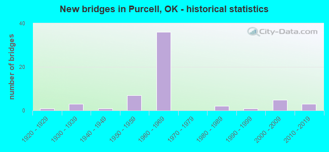
- New bridges - historical statistics
- 11920-1929
- 31930-1939
- 11940-1949
- 71950-1959
- 361960-1969
- 21980-1989
- 11990-1999
- 52000-2009
- 32010-2019
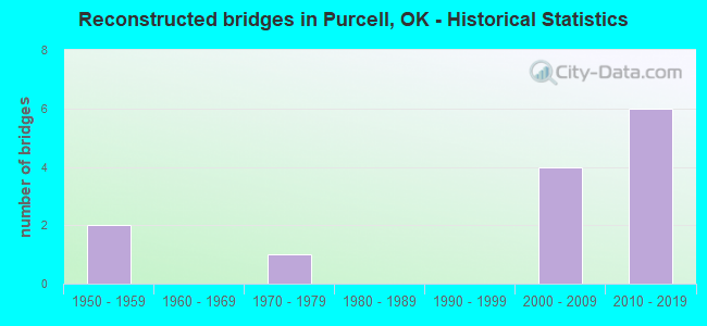
- Reconstructed bridges - Historical Statistics
- 21950-1959
- 01960-1969
- 11970-1979
- 01980-1989
- 01990-1999
- 42000-2009
- 62010-2019
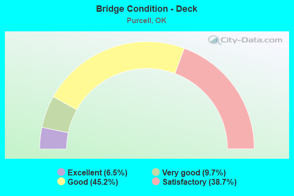
- Bridge Condition - Deck
- 6.5%Excellent
- 9.7%Very good
- 45.2%Good
- 38.7%Satisfactory
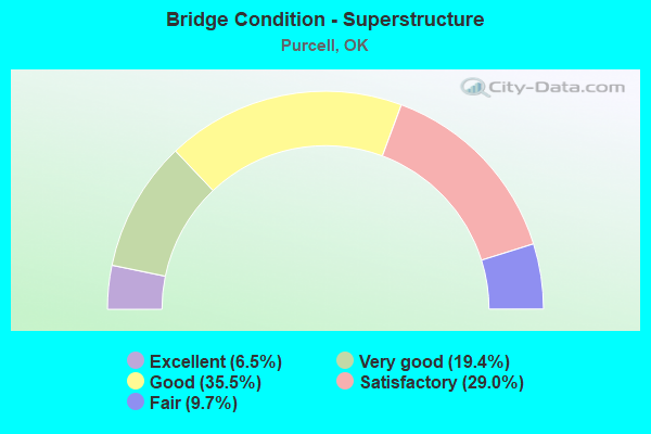
- Bridge Condition - Superstructure
- 6.5%Excellent
- 19.4%Very good
- 35.5%Good
- 29.0%Satisfactory
- 9.7%Fair
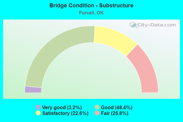
- Bridge Condition - Substructure
- 3.2%Very good
- 48.4%Good
- 22.6%Satisfactory
- 25.8%Fair
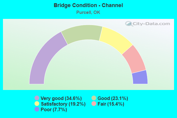
- Bridge Condition - Channel
- 34.6%Very good
- 23.1%Good
- 19.2%Satisfactory
- 15.4%Fair
- 7.7%Poor
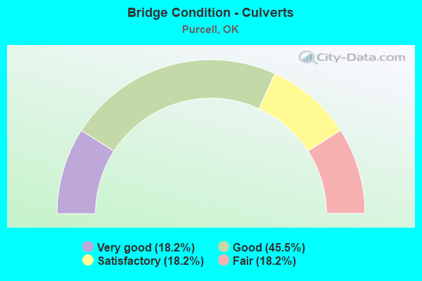
- Bridge Condition - Culverts
- 18.2%Very good
- 45.5%Good
- 18.2%Satisfactory
- 18.2%Fair
Find on map >> Show street view
Structure Number: 30279, Location: .5W OF STEALY (Lat: 34.927778, Lng: -97.416389), Route carried "on" structure: County highway E1440, Year Built: 2011, Status: Open, Structure Length: 1.37m (4.49ft), Average Daily Traffic: 100 (year 2020), Truck Traffic: 10%, Average Future Daily Traffic: 160 (year 2040), Design Load: HS 20, Features Intersected: CREEK
Minimum Vertical Clearance: 30+ m (98+ ft), Kilometerpoint: 0.805, Lanes on structure: 2, Owner: County Highway Agency, Approaching Roadway Width: 7.3m (24.0ft), Skew: 1 degrees, Material/Design: Steel, Design/Construction: Stringer/Multi-beam, Number Of Spans In Main Unit: 1, Length of Maximum Span: 13.1m (43.0ft), Curb-To-Curb Width: 8.1m (26.6ft), Out-to-Out Width: 8.3m (27.2ft)
Condition: Deck: Satisfactory, Superstructure: Satisfactory, Substructure: Satisfactory, Channel: Very good, Operating Rating: 68.0 metric tons, Method Used To Determine Operating Rating: Load Factor (LF), Inventory Rating: 40.8 metric tons, Method Used To Determine Inventory Rating: Load Factor (LF), Structural Evaluation: Equal to present minimum criteria, Deck Geometry: Equal to present minimum criteria, Waterway Adequacy: Equal to present desirable criteria, Approach Roadway Alignment: Equal to present desirable criteria, Designated Inspection Frequency: Every 24 months, Inspection Date: May 2021, Deck Structure Type: Concrete Cast-file-Place, Wearing Surface/Protective System: Wearing Surface: Monolithic Concrete
Find on map >> Show street view
Structure Number: 3041, Location: 2E OF WASHINGTON (Lat: 35.058889, Lng: -97.450556), Route carried "on" structure: County highway E1350, Year Built: 2012, Status: Open, Structure Length: 1.22m (4.00ft), Average Daily Traffic: 100 (year 2020), Truck Traffic: 10%, Average Future Daily Traffic: 160 (year 2040), Design Load: HS 20, Features Intersected: WALNUT CREEK BRANCH
Minimum Vertical Clearance: 30+ m (98+ ft), Kilometerpoint: 0.805, Lanes on structure: 2, Owner: County Highway Agency, Approaching Roadway Width: 6.1m (20.0ft), Material/Design: Steel, Design/Construction: Stringer/Multi-beam, Number Of Spans In Main Unit: 1, Length of Maximum Span: 11.6m (38.1ft), Curb-To-Curb Width: 8.0m (26.2ft), Out-to-Out Width: 8.2m (26.9ft)
Condition: Deck: Good, Superstructure: Satisfactory, Substructure: Satisfactory, Channel: Good, Operating Rating: 90.7 metric tons, Method Used To Determine Operating Rating: Load Factor (LF), Inventory Rating: 74.4 metric tons, Method Used To Determine Inventory Rating: Load Factor (LF), Structural Evaluation: Equal to present minimum criteria, Deck Geometry: Equal to present minimum criteria, Waterway Adequacy: Equal to present desirable criteria, Approach Roadway Alignment: Equal to present desirable criteria, Designated Inspection Frequency: Every 24 months, Inspection Date: May 2021, Deck Structure Type: Concrete Cast-file-Place, Wearing Surface/Protective System: Wearing Surface: Monolithic Concrete
Find on map >> Show street view
Structure Number: 31471, Location: .3 E JCT S.H. 74 (Lat: 35.013333, Lng: -97.358611), Route carried "on" structure: US 77, Year Built: 2019, Status: Open, Structure Length: 113.48m (372.31ft), Average Daily Traffic: 17,400 (year 2020), Average Future Daily Traffic: 27,840 (year 2040), Design Load: HL 93, Features Intersected: CANADIAN RIVER AND R.R.
Minimum Vertical Clearance: 30+ m (98+ ft), Kilometerpoint: 0.000, Lanes on structure: 4, Base Highway Network: Yes, Owner: State Highway Agency, Approaching Roadway Width: 26.5m (86.9ft), Material/Design: Steel, Design/Construction: Girder and Floorbeam System, Number Of Spans In Main Unit: 3, Number Of Approach Spans: 31, Length of Maximum Span: 61.0m (200.1ft), Curb or Sidewalk Widths: Left: 0.0m, Right: 1.8m (5.9ft), Curb-To-Curb Width: 26.5m (86.9ft), Out-to-Out Width: 26.5m (86.9ft)
Condition: Deck: Very good, Superstructure: Very good, Substructure: Good, Channel: Good, Operating Rating: 50.8 metric tons, Method Used To Determine Operating Rating: Load and Resistance Factor (LRFR), Inventory Rating: 23.6 metric tons, Method Used To Determine Inventory Rating: Load and Resistance Factor (LRFR), Structural Evaluation: Somewhat better than minimum adequacy, Deck Geometry: Superior to present desirable criteria, Underclear: Superior to present desirable criteria, Waterway Adequacy: Superior to present desirable criteria, Approach Roadway Alignment: Superior to present desirable criteria, Designated Inspection Frequency: Every 24 months, Inspection Date: March 2020, Deck Structure Type: Concrete Cast-file-Place, Wearing Surface/Protective System: Wearing Surface: Monolithic Concrete, Deck Protection: Epoxy Coated Reinforcing
Find on map >> Show street view
Structure Number: 14375, Location: 9.2 MI S CLEV. C/L (Lat: 35.079289, Lng: -97.407783), Route carried "under" structure: County highway E1335, Year Built: 1959, Structure Length: 0. m, Average Daily Traffic: 400 (year 2020), Truck Traffic: 15%, Features Intersected: E1335 JOHNSON RD. UNDER, Facility Carried by Structure: I-35
Minimum Vertical Clearance: 4.67m (15.32ft), Kilometerpoint: 26.598, Lanes on structure: 2, Lanes under structure: 2, Material/Design: Concrete continuous, Design/Construction: Slab, Length of Maximum Span: 12.2m (40.0ft)
Find on map >> Show street view
Structure Number: 14376, Location: 9.2 MI S CLEV. C/L (Lat: 35.079106, Lng: -97.408061), Route carried "under" structure: County highway E1335, Year Built: 1959, Structure Length: 0. m, Average Daily Traffic: 100 (year 2020), Truck Traffic: 15%, Features Intersected: E1335 JOHNSON RD. UNDER, Facility Carried by Structure: I-35
Minimum Vertical Clearance: 4.59m (15.06ft), Kilometerpoint: 26.598, Lanes on structure: 2, Lanes under structure: 2, Material/Design: Concrete continuous, Design/Construction: Slab, Length of Maximum Span: 12.2m (40.0ft)
Find on map >> Show street view
Structure Number: 14443, Location: 11.1 MI S CLEV. C/L (Lat: 35.057131, Lng: -97.387014), Route carried "under" structure: Interstate 35, Year Built: 1959, Structure Length: 0. m, Average Daily Traffic: 35,900 (year 2020), Truck Traffic: 36%, Features Intersected: I-35 UNDER
Minimum Vertical Clearance: 5.24m (17.19ft), Kilometerpoint: 23.524, Lanes on structure: 2, Lanes under structure: 4, Material/Design: Concrete continuous, Design/Construction: Slab, Length of Maximum Span: 16.8m (55.1ft)
Find on map >> Show street view
Structure Number: 16938, Location: 1.2 MI N JCT SH 39 (Lat: 35.015319, Lng: -97.375556), Route carried "under" structure: City street , Year Built: 1967, Structure Length: 0. m, Average Daily Traffic: 300 (year 2020), Truck Traffic: 5%, Features Intersected: ADAMS ST. UNDER, Facility Carried by Structure: I-35
Minimum Vertical Clearance: 4.85m (15.91ft), Kilometerpoint: 18.536, Lanes on structure: 2, Lanes under structure: 2, Material/Design: Steel, Design/Construction: Stringer/Multi-beam, Length of Maximum Span: 14.3m (46.9ft)
Find on map >> Show street view
Structure Number: 16939, Location: 1.2 MI N JCT SH 39 (Lat: 35.015317, Lng: -97.376111), Route carried "under" structure: City street , Year Built: 1967, Structure Length: 0. m, Average Daily Traffic: 300 (year 2020), Truck Traffic: 5%, Features Intersected: ADAMS ST. UNDER, Facility Carried by Structure: I-35
Minimum Vertical Clearance: 4.85m (15.91ft), Kilometerpoint: 18.536, Lanes on structure: 2, Lanes under structure: 2, Material/Design: Steel, Design/Construction: Stringer/Multi-beam, Length of Maximum Span: 14.3m (46.9ft)
Find on map >> Show street view
Structure Number: 1694, Location: JCT I-35 & SH 74 (Lat: 35.029806, Lng: -97.375739), Route carried "under" structure: State highway 74, Year Built: 1967, Structure Length: 0. m, Average Daily Traffic: 1,600 (year 2020), Truck Traffic: 15%, Features Intersected: S.H. 74 UNDER, Facility Carried by Structure: I-35
Minimum Vertical Clearance: 4.59m (15.06ft), Kilometerpoint: 2.623, Lanes on structure: 2, Lanes under structure: 2, Material/Design: Steel, Design/Construction: Stringer/Multi-beam, Length of Maximum Span: 14.3m (46.9ft)
Find on map >> Show street view
Structure Number: 16941, Location: JCT I-35 & SH 74 (Lat: 35.029806, Lng: -97.376097), Route carried "under" structure: State highway 74, Year Built: 1967, Structure Length: 0. m, Average Daily Traffic: 1,600 (year 2020), Truck Traffic: 15%, Features Intersected: S.H. 74 UNDER, Facility Carried by Structure: I-35
Minimum Vertical Clearance: 4.95m (16.24ft), Kilometerpoint: 2.639, Lanes on structure: 2, Lanes under structure: 2, Material/Design: Steel, Design/Construction: Stringer/Multi-beam, Length of Maximum Span: 14.3m (46.9ft)
Find on map >> Show street view
Structure Number: 16999, Location: JCT I-35 & SH 74G (Lat: 35.045425, Lng: -97.376886), Route carried "under" structure: State highway , Year Built: 1967, Structure Length: 0. m, Average Daily Traffic: 400 (year 2020), Truck Traffic: 15%, Features Intersected: S.H. 74 SB RAMP UNDER, Facility Carried by Structure: I-35 NB
Minimum Vertical Clearance: 4.87m (15.98ft), Kilometerpoint: 22.043, Lanes on structure: 2, Lanes under structure: 2, Material/Design: Steel continuous, Design/Construction: Stringer/Multi-beam, Length of Maximum Span: 23.2m (76.1ft)
Find on map >> Show street view
Structure Number: 17006, Location: 7.5 MI N GARVIN C/L (Lat: 34.956944, Lng: -97.368611), Route carried "under" structure: Interstate 35, Year Built: 1967, Structure Length: 0. m, Average Daily Traffic: 32,300 (year 2020), Truck Traffic: 36%, Features Intersected: I-35 UNDER, Facility Carried by Structure: E1420
Minimum Vertical Clearance: 5.03m (16.50ft), Kilometerpoint: 12.068, Lanes on structure: 2, Lanes under structure: 4, Material/Design: Steel continuous, Design/Construction: Stringer/Multi-beam, Length of Maximum Span: 26.5m (86.9ft)
Find on map >> Show street view
Structure Number: 17207, Location: JCT I-35 & SH 39 (Lat: 34.998506, Lng: -97.375172), Route carried "under" structure: State highway 39, Year Built: 1968, Structure Length: 0. m, Average Daily Traffic: 2,700 (year 2020), Truck Traffic: 7%, Features Intersected: S.H. 39 UNDER, Facility Carried by Structure: I-35
Minimum Vertical Clearance: 4.57m (14.99ft), Kilometerpoint: 11.133, Lanes on structure: 2, Lanes under structure: 2, Material/Design: Steel, Design/Construction: Stringer/Multi-beam, Length of Maximum Span: 14.6m (47.9ft)
Find on map >> Show street view
Structure Number: 17208, Location: JCT I-35 & SH 39 (Lat: 34.998506, Lng: -97.374806), Route carried "under" structure: State highway 39, Year Built: 1968, Structure Length: 0. m, Average Daily Traffic: 2,700 (year 2020), Truck Traffic: 7%, Features Intersected: S.H. 39 UNDER, Facility Carried by Structure: I-35
Minimum Vertical Clearance: 4.57m (14.99ft), Kilometerpoint: 11.166, Lanes on structure: 2, Lanes under structure: 2, Material/Design: Steel, Design/Construction: Stringer/Multi-beam, Length of Maximum Span: 14.6m (47.9ft)
Find on map >> Show street view
Structure Number: 17216, Location: 4.4 MI N GARVIN C/L (Lat: 34.913264, Lng: -97.355497), Route carried "under" structure: State highway 59, Year Built: 1968, Structure Length: 0. m, Average Daily Traffic: 730 (year 2020), Truck Traffic: 15%, Features Intersected: S.H. 59 UNDER, Facility Carried by Structure: I-35
Minimum Vertical Clearance: 4.90m (16.08ft), Kilometerpoint: 4.617, Lanes on structure: 2, Lanes under structure: 2, Material/Design: Concrete continuous, Design/Construction: Slab, Length of Maximum Span: 15.8m (51.8ft)
Find on map >> Show street view
Structure Number: 17217, Location: 4.4 MI N GARVIN C/L (Lat: 34.913267, Lng: -97.354925), Route carried "under" structure: State highway 59, Year Built: 1968, Structure Length: 0. m, Average Daily Traffic: 730 (year 2020), Truck Traffic: 15%, Features Intersected: S.H. 59 UNDER, Facility Carried by Structure: I-35
Minimum Vertical Clearance: 4.90m (16.08ft), Kilometerpoint: 4.665, Lanes on structure: 2, Lanes under structure: 2, Material/Design: Concrete continuous, Design/Construction: Slab, Length of Maximum Span: 15.8m (51.8ft)
Find on map >> Show street view
Structure Number: 17327, Location: .3 MI N JCT SH 74 (Lat: 34.986111, Lng: -97.372778), Route carried "under" structure: Interstate 35, Year Built: 1968, Structure Length: 0. m, Average Daily Traffic: 31,400 (year 2020), Truck Traffic: 12%, Features Intersected: I-35 UNDER, Facility Carried by Structure: CHANDLER RD.
Minimum Vertical Clearance: 5.12m (16.80ft), Kilometerpoint: 15.318, Lanes on structure: 2, Lanes under structure: 4, Material/Design: Steel continuous, Design/Construction: Stringer/Multi-beam, Length of Maximum Span: 23.5m (77.1ft)
Find on map >> Show street view
Structure Number: 17337, Location: JCT I-35 & SH 74 (Lat: 34.982222, Lng: -97.372778), Route carried "under" structure: Interstate 35, Year Built: 1968, Structure Length: 0. m, Average Daily Traffic: 31,400 (year 2020), Truck Traffic: 12%, Features Intersected: I-35 UNDER, Facility Carried by Structure: S.H. 74 EB
Minimum Vertical Clearance: 5.35m (17.55ft), Kilometerpoint: 14.915, Lanes on structure: 2, Lanes under structure: 4, Material/Design: Steel continuous, Design/Construction: Stringer/Multi-beam, Length of Maximum Span: 22.3m (73.2ft)
Find on map >> Show street view
Structure Number: 17338, Location: JCT I-35 & SH 74 (Lat: 34.983056, Lng: -97.372222), Route carried "under" structure: Interstate 35, Year Built: 1968, Structure Length: 0. m, Average Daily Traffic: 31,400 (year 2020), Truck Traffic: 12%, Features Intersected: I-35 UNDER, Facility Carried by Structure: S.H. 74 WB
Minimum Vertical Clearance: 5.46m (17.91ft), Kilometerpoint: 14.931, Lanes on structure: 2, Lanes under structure: 4, Material/Design: Steel continuous, Design/Construction: Stringer/Multi-beam, Length of Maximum Span: 22.3m (73.2ft)
Find on map >> Show street view
Structure Number: 17341, Location: 3.1 MI N GARVIN C/L (Lat: 34.896144, Lng: -97.344669), Route carried "under" structure: Interstate 35, Year Built: 1968, Structure Length: 0. m, Average Daily Traffic: 32,200 (year 2020), Truck Traffic: 36%, Features Intersected: I-35 UNDER, Facility Carried by Structure: N3175
Minimum Vertical Clearance: 5.08m (16.67ft), Kilometerpoint: 4.907, Lanes on structure: 2, Lanes under structure: 4, Material/Design: Steel continuous, Design/Construction: Stringer/Multi-beam, Length of Maximum Span: 27.1m (88.9ft)