Bridge Statistics for Radnor Township, Pennsylvania (PA)
Condition, Traffic, Stress, Structural Evaluation, Project Costs
- National Bridge Inventory (NBI) Statistics
- 59Number of bridges
- 384ft / 117mTotal length
- $4,883,000Total costs
- 1,330,468Total average daily traffic
- 110,166Total average daily truck traffic
- National Bridge Inventory (NBI) Registered Bridges for Radnor Township
- No street view available for this location
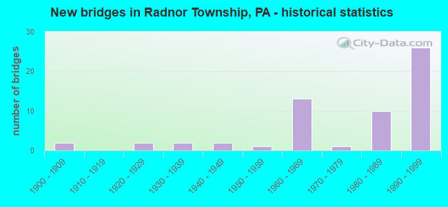
- New bridges - historical statistics
- 21900-1909
- 21920-1929
- 21930-1939
- 21940-1949
- 11950-1959
- 131960-1969
- 11970-1979
- 101980-1989
- 261990-1999
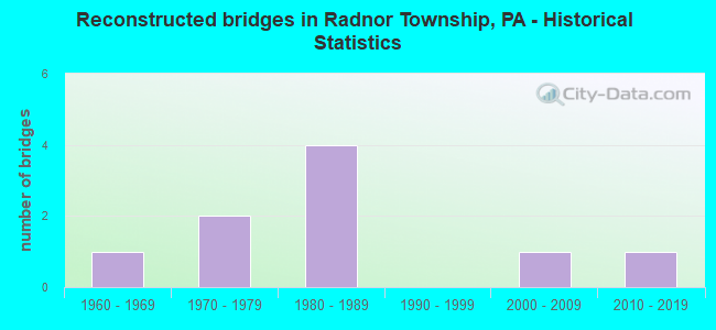
- Reconstructed bridges - Historical Statistics
- 11960-1969
- 21970-1979
- 41980-1989
- 01990-1999
- 12000-2009
- 12010-2019
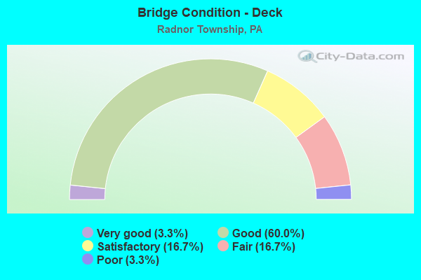
- Bridge Condition - Deck
- 3.3%Very good
- 60.0%Good
- 16.7%Satisfactory
- 16.7%Fair
- 3.3%Poor
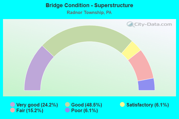
- Bridge Condition - Superstructure
- 24.2%Very good
- 48.5%Good
- 6.1%Satisfactory
- 15.2%Fair
- 6.1%Poor
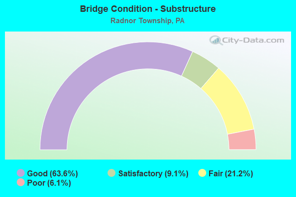
- Bridge Condition - Substructure
- 63.6%Good
- 9.1%Satisfactory
- 21.2%Fair
- 6.1%Poor
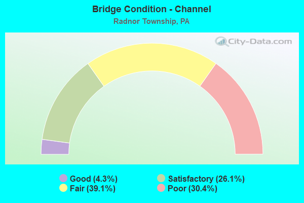
- Bridge Condition - Channel
- 4.3%Good
- 26.1%Satisfactory
- 39.1%Fair
- 30.4%Poor
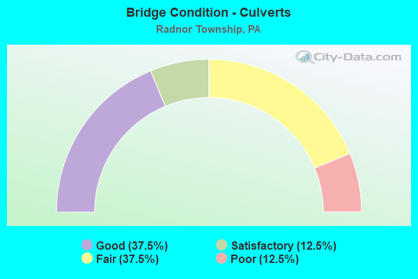
- Bridge Condition - Culverts
- 37.5%Good
- 12.5%Satisfactory
- 37.5%Fair
- 12.5%Poor
Find on map >> Show street view
Structure Number: 54852, Location: N OF BRYN MAWR AVE (Lat: 40.014494, Lng: -75.341214), Route carried "on" structure: City street , Year Built: 1959, Year Reconstructed: 1982, Status: Open, Structure Length: 0.94m (3.08ft), Average Daily Traffic: 50 (year 2018), Average Future Daily Traffic: 75 (year 2043), Design Load: HS 20, Features Intersected: MEADOWBROOK RUN, Facility Carried by Structure: HARVARD LN
Minimum Vertical Clearance: 30+ m (98+ ft), Kilometerpoint: 0.000, Lanes on structure: 2, Toll: Toll bridge, Owner: Town or Township Highway Agency, Approaching Roadway Width: 7.3m (24.0ft), Material/Design: Prestressed concrete, Design/Construction: Box Beam or Girders - Multiple, Number Of Spans In Main Unit: 1, Length of Maximum Span: 8.2m (26.9ft), Curb-To-Curb Width: 7.3m (24.0ft), Out-to-Out Width: 11.0m (36.1ft)
Condition: Deck: Fair, Superstructure: Fair, Substructure: Good, Channel: Fair, Operating Rating: 56.2 metric tons, Method Used To Determine Operating Rating: Load Factor (LF), Inventory Rating: 33.6 metric tons, Method Used To Determine Inventory Rating: Load Factor (LF), Structural Evaluation: Somewhat better than minimum adequacy, Deck Geometry: Equal to present minimum criteria, Waterway Adequacy: Better than present minimum criteria, Approach Roadway Alignment: Equal to present minimum criteria, Designated Inspection Frequency: Every 24 months, Inspection Date: August 2020, Deck Structure Type: Concrete Cast-file-Place, Wearing Surface/Protective System: Wearing Surface: Bituminous
Find on map >> Show street view
Structure Number: 54853, Location: E OF LAURIER PLACE (Lat: 40.009000, Lng: -75.343000), Route carried "on" structure: City street , Year Built: 1994, Status: Open, Structure Length: 0.73m (2.40ft), Average Daily Traffic: 90 (year 2018), Average Future Daily Traffic: 200 (year 2038), Design Load: HL 93, Features Intersected: BRNCH OF MEADOWBROOK RUN, Facility Carried by Structure: E LAURIER PL
Minimum Vertical Clearance: 30+ m (98+ ft), Kilometerpoint: 0.000, Lanes on structure: 2, Owner: Town or Township Highway Agency, Approaching Roadway Width: 6.1m (20.0ft), Skew: 6 degrees, Material/Design: Steel, Design/Construction: Culvert, Number Of Spans In Main Unit: 1, Length of Maximum Span: 7.3m (24.0ft)
Condition: Channel: Satisfactory, Culverts: Good, Operating Rating: 49.0 metric tons, Method Used To Determine Operating Rating: Field evaluation and documented engineering judgment, Inventory Rating: 32.7 metric tons, Method Used To Determine Inventory Rating: Field evaluation and documented engineering judgment, Structural Evaluation: Better than present minimum criteria, Waterway Adequacy: Better than present minimum criteria, Approach Roadway Alignment: Equal to present desirable criteria, Designated Inspection Frequency: Every 24 months, Inspection Date: July 2020
Find on map >> Show street view
Structure Number: 14979, Location: VILLANOVA STATION 14K09 (Lat: 40.038894, Lng: -75.342600), Route carried "under" structure: ServiceOther road , Year Built: 1993, Structure Length: 0. m, Average Daily Traffic: 7 (year 2006), Truck Traffic: 7%, Features Intersected: AMTRAK(MAIN LINE);ACCESS, Facility Carried by Structure: SPRING MILL ROAD
Minimum Vertical Clearance: 5.21m (17.09ft), Kilometerpoint: 0.000, Lanes on structure: 2, Lanes under structure: 2, Material/Design: Steel continuous, Design/Construction: Stringer/Multi-beam, Length of Maximum Span: 29.9m (98.1ft)
Find on map >> Show street view
Structure Number: 15118, Location: RADNOR TOWNSHIP 25H02 (Lat: 40.007108, Lng: -75.354297), Route carried "under" structure: State highway , Year Built: 1967, Structure Length: 0. m, Average Daily Traffic: 10,501 (year 2022), Truck Traffic: 3%, Features Intersected: BRYN MAWR AVENUE, Facility Carried by Structure: MID-COUNTY EXWY.NB
Minimum Vertical Clearance: 4.37m (14.34ft), Kilometerpoint: 3.462, Lanes on structure: 3, Lanes under structure: 2, Material/Design: Prestressed concrete, Design/Construction: Box Beam or Girders - Single/Spread, Length of Maximum Span: 19.5m (64.0ft)
Find on map >> Show street view
Structure Number: 15123, Location: RADNOR TOWNSHIP 3477D09 (Lat: 40.007069, Lng: -75.354672), Route carried "under" structure: State highway , Year Built: 1967, Structure Length: 0. m, Average Daily Traffic: 10,501 (year 2022), Truck Traffic: 3%, Features Intersected: BRYN MAWR AVENUE, Facility Carried by Structure: MID-COUNTY EXWY.SB
Minimum Vertical Clearance: 4.54m (14.90ft), Kilometerpoint: 3.462, Lanes on structure: 3, Lanes under structure: 2, Material/Design: Prestressed concrete, Design/Construction: Box Beam or Girders - Single/Spread, Length of Maximum Span: 19.5m (64.0ft)
Find on map >> Show street view
Structure Number: 15127, Location: RADNOR TOWNSHIP 25H01 (Lat: 40.014581, Lng: -75.357078), Route carried "under" structure: State highway , Year Built: 1967, Structure Length: 0. m, Average Daily Traffic: 950 (year 1980), Features Intersected: CLYDE ROAD, Facility Carried by Structure: MID-COUNTY EXWY.NB
Minimum Vertical Clearance: 4.50m (14.76ft), Kilometerpoint: 0.000, Lanes on structure: 3, Lanes under structure: 2, Material/Design: Prestressed concrete, Design/Construction: Box Beam or Girders - Single/Spread, Length of Maximum Span: 16.8m (55.1ft)
Find on map >> Show street view
Structure Number: 15129, Location: RADNOR TOWNSHIP 25H01 (Lat: 40.014456, Lng: -75.357383), Route carried "under" structure: State highway , Year Built: 1967, Structure Length: 0. m, Average Daily Traffic: 950 (year 1980), Features Intersected: CLYDE ROAD, Facility Carried by Structure: MID-COUNTY EXWY.SB
Minimum Vertical Clearance: 5.36m (17.59ft), Kilometerpoint: 0.000, Lanes on structure: 3, Lanes under structure: 2, Material/Design: Prestressed concrete, Design/Construction: Box Beam or Girders - Single/Spread, Length of Maximum Span: 16.8m (55.1ft)
Find on map >> Show street view
Structure Number: 15133, Location: CONESTOGA;SPROUL 14G11 (Lat: 40.030197, Lng: -75.362964), Route carried "under" structure: State highway , Year Built: 1989, Structure Length: 0. m, Average Daily Traffic: 8,295 (year 2022), Truck Traffic: 2%, Features Intersected: CONESTOGA RD & SPROUL RD, Facility Carried by Structure: MID-COUNTY EXWY.NB
Minimum Vertical Clearance: 5.03m (16.50ft), Kilometerpoint: 3.224, Lanes on structure: 3, Lanes under structure: 2, Material/Design: Steel, Design/Construction: Stringer/Multi-beam, Length of Maximum Span: 67.7m (222.1ft)
Find on map >> Show street view
Structure Number: 15133, Location: CONESTOGA;SPROUL 14G11 (Lat: 40.030197, Lng: -75.362964), Route carried "under" structure: State highway 320, Year Built: 1989, Structure Length: 0. m, Average Daily Traffic: 7,979 (year 2022), Truck Traffic: 4%, Features Intersected: CONESTOGA RD & SPROUL RD, Facility Carried by Structure: MID-COUNTY EXWY.NB
Minimum Vertical Clearance: 4.85m (15.91ft), Kilometerpoint: 21.713, Lanes on structure: 3, Lanes under structure: 2, Material/Design: Steel, Design/Construction: Stringer/Multi-beam, Length of Maximum Span: 67.7m (222.1ft)
Find on map >> Show street view
Structure Number: 15138, Location: CONESTOGA;SPROUL 14G11 (Lat: 40.029744, Lng: -75.363378), Route carried "under" structure: State highway 320, Year Built: 1989, Structure Length: 0. m, Average Daily Traffic: 7,979 (year 2022), Truck Traffic: 4%, Features Intersected: CONESTOGA RD & SPROUL RD, Facility Carried by Structure: MID-COUNTY EXWY.SB
Minimum Vertical Clearance: 5.36m (17.59ft), Kilometerpoint: 21.713, Lanes on structure: 3, Lanes under structure: 4, Material/Design: Steel continuous, Design/Construction: Stringer/Multi-beam, Length of Maximum Span: 66.8m (219.2ft)
Find on map >> Show street view
Structure Number: 15138, Location: CONESTOGA;SPROUL 14G11 (Lat: 40.029744, Lng: -75.363378), Route carried "under" structure: State highway , Year Built: 1989, Structure Length: 0. m, Average Daily Traffic: 8,295 (year 2022), Truck Traffic: 2%, Features Intersected: CONESTOGA RD & SPROUL RD, Facility Carried by Structure: MID-COUNTY EXWY.SB
Minimum Vertical Clearance: 5.36m (17.59ft), Kilometerpoint: 3.224, Lanes on structure: 3, Lanes under structure: 4, Material/Design: Steel continuous, Design/Construction: Stringer/Multi-beam, Length of Maximum Span: 66.8m (219.2ft)
Find on map >> Show street view
Structure Number: 1514, Location: NEAR VILLANOVA 14H10 (Lat: 40.036022, Lng: -75.356553), Route carried "under" structure: Ramp State highway , Year Built: 1990, Structure Length: 0. m, Average Daily Traffic: 8,138 (year 2021), Truck Traffic: 7%, Features Intersected: RAMP N-L;OFF TO TR 30, Facility Carried by Structure: MID-COUNTY EXWY.NB
Minimum Vertical Clearance: 5.28m (17.32ft), Kilometerpoint: 0.000, Lanes on structure: 3, Lanes under structure: 4, Material/Design: Steel, Design/Construction: Stringer/Multi-beam, Length of Maximum Span: 36.3m (119.1ft)
Find on map >> Show street view
Structure Number: 15141, Location: LANCASTER AVE.INT. 14H10 (Lat: 40.036831, Lng: -75.355122), Route carried "under" structure: US 30, Year Built: 1990, Structure Length: 0. m, Average Daily Traffic: 9,674 (year 2020), Truck Traffic: 8%, Features Intersected: LANCASTER AVENUE, Facility Carried by Structure: MID-COUNTY EXWY.NB
Minimum Vertical Clearance: 5.23m (17.16ft), Kilometerpoint: 4.245, Lanes on structure: 3, Lanes under structure: 2, Material/Design: Steel, Design/Construction: Stringer/Multi-beam, Length of Maximum Span: 51.8m (169.9ft)
Find on map >> Show street view
Structure Number: 15141, Location: LANCASTER AVE.INT. 14H10 (Lat: 40.036831, Lng: -75.355122), Route carried "under" structure: US 30, Year Built: 1990, Structure Length: 0. m, Average Daily Traffic: 11,718 (year 2020), Truck Traffic: 3%, Features Intersected: LANCASTER AVENUE, Facility Carried by Structure: MID-COUNTY EXWY.NB
Minimum Vertical Clearance: 5.33m (17.49ft), Kilometerpoint: 4.242, Lanes on structure: 3, Lanes under structure: 2, Material/Design: Steel, Design/Construction: Stringer/Multi-beam, Length of Maximum Span: 51.8m (169.9ft)
Find on map >> Show street view
Structure Number: 15144, Location: NEAR VILLANOVA 14H10 (Lat: 40.036361, Lng: -75.356478), Route carried "under" structure: Ramp State highway , Year Built: 1990, Structure Length: 0. m, Average Daily Traffic: 8,138 (year 2021), Truck Traffic: 7%, Features Intersected: RAMP N-L;OFF TO TR-30, Facility Carried by Structure: MID-COUNTY EXWY.SB
Minimum Vertical Clearance: 6.04m (19.82ft), Kilometerpoint: 0.000, Lanes on structure: 3, Lanes under structure: 4, Material/Design: Steel, Design/Construction: Stringer/Multi-beam, Length of Maximum Span: 36.3m (119.1ft)
Find on map >> Show street view
Structure Number: 15145, Location: LANCASTER AVE.INT. 14H10 (Lat: 40.036869, Lng: -75.355533), Route carried "under" structure: US 30, Year Built: 1990, Structure Length: 0. m, Average Daily Traffic: 9,674 (year 2020), Truck Traffic: 8%, Features Intersected: LANCASTER AVE / 3477-D5, Facility Carried by Structure: MID-COUNTY EXWY.SB
Minimum Vertical Clearance: 5.00m (16.40ft), Kilometerpoint: 4.245, Lanes on structure: 3, Lanes under structure: 2, Material/Design: Steel, Design/Construction: Stringer/Multi-beam, Length of Maximum Span: 53.3m (174.9ft)
Find on map >> Show street view
Structure Number: 15145, Location: LANCASTER AVE.INT. 14H10 (Lat: 40.036869, Lng: -75.355533), Route carried "under" structure: US 30, Year Built: 1990, Structure Length: 0. m, Average Daily Traffic: 11,718 (year 2020), Truck Traffic: 3%, Features Intersected: LANCASTER AVE / 3477-D5, Facility Carried by Structure: MID-COUNTY EXWY.SB
Minimum Vertical Clearance: 4.98m (16.34ft), Kilometerpoint: 4.242, Lanes on structure: 3, Lanes under structure: 2, Material/Design: Steel, Design/Construction: Stringer/Multi-beam, Length of Maximum Span: 53.3m (174.9ft)
Find on map >> Show street view
Structure Number: 15501, Location: LANCASTER AVE.INT. 14H10 (Lat: 40.036667, Lng: -75.356667), Route carried "under" structure: US 30, Year Built: 1990, Structure Length: 0. m, Average Daily Traffic: 9,674 (year 2020), Truck Traffic: 8%, Features Intersected: LANCASTER AVENUE/3477-D5
Minimum Vertical Clearance: 5.43m (17.81ft), Kilometerpoint: 4.245, Lanes on structure: 1, Lanes under structure: 2, Material/Design: Steel, Design/Construction: Stringer/Multi-beam, Length of Maximum Span: 55.2m (181.1ft)
Find on map >> Show street view
Structure Number: 15501, Location: LANCASTER AVE.INT. 14H10 (Lat: 40.036667, Lng: -75.356667), Route carried "under" structure: US 30, Year Built: 1990, Structure Length: 0. m, Average Daily Traffic: 11,718 (year 2020), Truck Traffic: 3%, Features Intersected: LANCASTER AVENUE/3477-D5
Minimum Vertical Clearance: 5.43m (17.81ft), Kilometerpoint: 4.242, Lanes on structure: 1, Lanes under structure: 2, Material/Design: Steel, Design/Construction: Stringer/Multi-beam, Length of Maximum Span: 55.2m (181.1ft)
Find on map >> Show street view
Structure Number: 15502, Location: NEAR VILLANOVA 14H10 (Lat: 40.037372, Lng: -75.354908), Route carried "under" structure: Ramp State highway , Year Built: 1990, Structure Length: 0. m, Average Daily Traffic: 8,138 (year 2021), Truck Traffic: 7%, Features Intersected: RAMP N-L (NB OFF TO 30), Facility Carried by Structure: RAMP S-L(SB OFF)
Minimum Vertical Clearance: 6.37m (20.90ft), Kilometerpoint: 0.000, Lanes on structure: 1, Lanes under structure: 1, Material/Design: Steel, Design/Construction: Stringer/Multi-beam, Length of Maximum Span: 36.3m (119.1ft)