Bridge Statistics for Rapid City, South Dakota (SD)
Condition, Traffic, Stress, Structural Evaluation, Project Costs
- National Bridge Inventory (NBI) Statistics
- 111Number of bridges
- 1,063ft / 324mTotal length
- $6,961,000Total costs
- 987,903Total average daily traffic
- 55,193Total average daily truck traffic
- National Bridge Inventory (NBI) Registered Bridges for Rapid City
- No street view available for this location
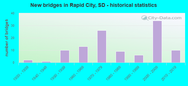
- New bridges - historical statistics
- 21930-1939
- 11940-1949
- 101950-1959
- 131960-1969
- 261970-1979
- 91980-1989
- 61990-1999
- 342000-2009
- 102010-2019
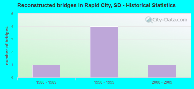
- Reconstructed bridges - Historical Statistics
- 11980-1989
- 41990-1999
- 12000-2009
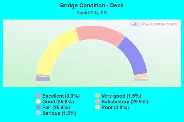
- Bridge Condition - Deck
- 3.0%Excellent
- 1.5%Very good
- 35.8%Good
- 29.9%Satisfactory
- 25.4%Fair
- 3.0%Poor
- 1.5%Serious
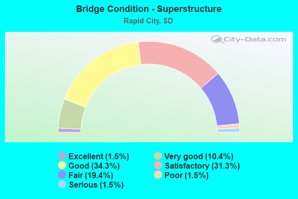
- Bridge Condition - Superstructure
- 1.5%Excellent
- 10.4%Very good
- 34.3%Good
- 31.3%Satisfactory
- 19.4%Fair
- 1.5%Poor
- 1.5%Serious
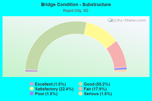
- Bridge Condition - Substructure
- 1.5%Excellent
- 55.2%Good
- 22.4%Satisfactory
- 17.9%Fair
- 1.5%Poor
- 1.5%Serious
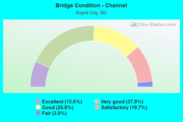
- Bridge Condition - Channel
- 13.6%Excellent
- 37.9%Very good
- 25.8%Good
- 19.7%Satisfactory
- 3.0%Fair

- Bridge Condition - Culverts
- 37.5%Very good
- 18.8%Good
- 37.5%Satisfactory
- 6.3%Serious
Find on map >> Show street view
Structure Number: 52490346, Location: 4 W & 1.4 N CAPUTA (Lat: 44.015389, Lng: -103.070733), Route carried "on" structure: County highway , Year Built: 1973, Status: Open, Structure Length: 3.35m (10.99ft), Average Daily Traffic: 106 (year 2019), Truck Traffic: 2%, Average Future Daily Traffic: 106 (year 2032), Design Load: HS 20+Mod, Features Intersected: RAPID CK, Facility Carried by Structure: S. AIRPORT ROAD
Minimum Vertical Clearance: 30+ m (98+ ft), Kilometerpoint: 0.000, Lanes on structure: 2, Owner: County Highway Agency, Approaching Roadway Width: 5.5m (18.0ft), Material/Design: Prestressed concrete, Design/Construction: Tee Beam, Number Of Spans In Main Unit: 3, Length of Maximum Span: 14.9m (48.9ft), Curb-To-Curb Width: 8.0m (26.2ft), Out-to-Out Width: 8.2m (26.9ft)
Condition: Deck: Good, Superstructure: Good, Substructure: Satisfactory, Channel: Good, Operating Rating: 53.8 metric tons, Method Used To Determine Operating Rating: Load Factor (LF), Inventory Rating: 31.0 metric tons, Method Used To Determine Inventory Rating: Load Factor (LF), Structural Evaluation: Equal to present minimum criteria, Deck Geometry: Somewhat better than minimum adequacy, Waterway Adequacy: Better than present minimum criteria, Approach Roadway Alignment: Equal to present minimum criteria, Designated Inspection Frequency: Every 24 months, Inspection Date: September 2020, Deck Structure Type: Concrete Precast Panels, Wearing Surface/Protective System: Wearing Surface: Monolithic Concrete
Find on map >> Show street view
Structure Number: 52500347, Location: 3.5 W & 1.3 N CAPUTA (Lat: 44.012992, Lng: -103.050758), Route carried "on" structure: County highway , Year Built: 2018, Status: Open, Structure Length: 1.71m (5.61ft), Average Daily Traffic: 325 (year 2019), Truck Traffic: 3%, Average Future Daily Traffic: 470 (year 2038), Design Load: HL 93, Features Intersected: RAPID CK, Facility Carried by Structure: BRADSKY ROAD
Minimum Vertical Clearance: 30+ m (98+ ft), Kilometerpoint: 0.000, Lanes on structure: 2, Owner: County Highway Agency, Approaching Roadway Width: 7.9m (25.9ft), Skew: 1 degrees, Material/Design: Prestressed concrete, Design/Construction: Tee Beam, Number Of Spans In Main Unit: 1, Length of Maximum Span: 16.8m (55.1ft), Curb-To-Curb Width: 8.5m (27.9ft), Out-to-Out Width: 9.1m (29.9ft)
Condition: Deck: Excellent, Superstructure: Very good, Substructure: Excellent, Channel: Excellent, Operating Rating: 65.3 metric tons, Method Used To Determine Operating Rating: Load and Resistance Factor (LRFR), Inventory Rating: 50.3 metric tons, Method Used To Determine Inventory Rating: Load and Resistance Factor (LRFR), Structural Evaluation: Equal to present desirable criteria, Deck Geometry: Equal to present minimum criteria, Waterway Adequacy: Superior to present desirable criteria, Approach Roadway Alignment: Meets minimum limits, Designated Inspection Frequency: Every 24 months, Inspection Date: September 2020, Deck Structure Type: Concrete Precast Panels, Wearing Surface/Protective System: Wearing Surface: Monolithic Concrete
Find on map >> Show street view
Structure Number: 52390278, Location: DEADWOOD AVE INTERCHANGE (Lat: 44.114731, Lng: -103.271592), Route carried "under" structure: Interstate 90, Year Built: 1983, Structure Length: 0. m, Average Daily Traffic: 24,000 (year 2020), Truck Traffic: 13%, Features Intersected: I090, Facility Carried by Structure: SD445
Minimum Vertical Clearance: 5.64m (18.50ft), Kilometerpoint: 89.576, Lanes on structure: 2, Lanes under structure: 4, Material/Design: Prestressed concrete continuous, Design/Construction: Stringer/Multi-beam, Length of Maximum Span: 38.0m (124.7ft)
Find on map >> Show street view
Structure Number: 52409294, Location: North St & I190 INTRCHGE (Lat: 44.089275, Lng: -103.232347), Route carried "under" structure: Ramp Interstate 190, Year Built: 2016, Structure Length: 0. m, Features Intersected: NORTH ST
Minimum Vertical Clearance: 5.26m (17.26ft), Kilometerpoint: 0.000, Lanes on structure: 2, Lanes under structure: 1, Material/Design: Steel, Design/Construction: Stringer/Multi-beam, Length of Maximum Span: 62.3m (204.4ft)
Find on map >> Show street view
Structure Number: 52409294, Location: North St & I190 INTRCHGE (Lat: 44.089275, Lng: -103.232347), Route carried "under" structure: Ramp Interstate 190, Year Built: 2016, Structure Length: 0. m, Features Intersected: NORTH ST
Minimum Vertical Clearance: 5.69m (18.67ft), Kilometerpoint: 0.000, Lanes on structure: 2, Lanes under structure: 1, Material/Design: Steel, Design/Construction: Stringer/Multi-beam, Length of Maximum Span: 62.3m (204.4ft)
Find on map >> Show street view
Structure Number: 52409294, Location: North St & I190 INTRCHGE (Lat: 44.089275, Lng: -103.232347), Route carried "under" structure: Ramp Interstate 190, Year Built: 2016, Structure Length: 0. m, Features Intersected: NORTH ST
Minimum Vertical Clearance: 5.39m (17.68ft), Kilometerpoint: 0.000, Lanes on structure: 2, Lanes under structure: 1, Material/Design: Steel, Design/Construction: Stringer/Multi-beam, Length of Maximum Span: 62.3m (204.4ft)
Find on map >> Show street view
Structure Number: 52409294, Location: North St & I190 INTRCHGE (Lat: 44.089275, Lng: -103.232347), Route carried "under" structure: City street , Year Built: 2016, Structure Length: 0. m, Average Daily Traffic: 100 (year 2020), Features Intersected: NORTH ST, Facility Carried by Structure: I190
Minimum Vertical Clearance: 5.43m (17.81ft), Kilometerpoint: 0.000, Lanes on structure: 2, Lanes under structure: 2, Material/Design: Steel, Design/Construction: Stringer/Multi-beam, Length of Maximum Span: 62.3m (204.4ft)
Find on map >> Show street view
Structure Number: 52409294, Location: North St & I190 INTRCHGE (Lat: 44.089275, Lng: -103.232347), Route carried "under" structure: Ramp Interstate 190, Year Built: 2016, Structure Length: 0. m, Features Intersected: NORTH ST
Minimum Vertical Clearance: 5.84m (19.16ft), Kilometerpoint: 0.000, Lanes on structure: 2, Lanes under structure: 1, Material/Design: Steel, Design/Construction: Stringer/Multi-beam, Length of Maximum Span: 62.3m (204.4ft)
Find on map >> Show street view
Structure Number: 52410285, Location: I 90 & I 190 INTERCHANGE (Lat: 44.104847, Lng: -103.232236), Route carried "under" structure: Interstate 90, Year Built: 2000, Structure Length: 0. m, Average Daily Traffic: 37,060 (year 2020), Truck Traffic: 10%, Features Intersected: I090
Minimum Vertical Clearance: 5.56m (18.24ft), Kilometerpoint: 92.972, Lanes on structure: 2, Lanes under structure: 5, Material/Design: Steel continuous, Design/Construction: Stringer/Multi-beam, Length of Maximum Span: 43.0m (141.1ft)
Find on map >> Show street view
Structure Number: 5241029, Location: 0.5 S I 90 INTERCH (Lat: 44.096664, Lng: -103.232025), Route carried "under" structure: Interstate 190, Year Built: 1959, Structure Length: 0. m, Average Daily Traffic: 18,866 (year 2020), Truck Traffic: 2%, Features Intersected: I190, Facility Carried by Structure: ANAMOSA ST
Minimum Vertical Clearance: 5.44m (17.85ft), Kilometerpoint: 1.400, Lanes on structure: 2, Lanes under structure: 4, Material/Design: Concrete continuous, Design/Construction: Slab, Length of Maximum Span: 14.5m (47.6ft)
Find on map >> Show street view
Structure Number: 52410318, Location: 1.9 S JCT SD 44 E (Lat: 44.055911, Lng: -103.231931), Route carried "under" structure: US 16, Year Built: 1964, Structure Length: 0. m, Average Daily Traffic: 12,812 (year 2020), Truck Traffic: 3%, Features Intersected: US016, Facility Carried by Structure: TOWER DRIVE
Minimum Vertical Clearance: 8.15m (26.74ft), Kilometerpoint: 107.939, Lanes on structure: 2, Lanes under structure: 4, Material/Design: Steel continuous, Design/Construction: Stringer/Multi-beam, Length of Maximum Span: 21.1m (69.2ft)
Find on map >> Show street view
Structure Number: 52415285, Location: HAINES AVE INTERCHANGE (Lat: 44.104475, Lng: -103.221017), Route carried "under" structure: Ramp Interstate 90, Year Built: 2001, Structure Length: 0. m, Average Daily Traffic: 22,021 (year 2020), Truck Traffic: 1%, Features Intersected: HAINES AVE
Minimum Vertical Clearance: 5.84m (19.16ft), Kilometerpoint: 93.133, Lanes on structure: 2, Lanes under structure: 4, Material/Design: Steel continuous, Design/Construction: Stringer/Multi-beam, Length of Maximum Span: 59.7m (195.9ft)
Find on map >> Show street view
Structure Number: 52415285, Location: HAINES AVE INTERCHANGE (Lat: 44.104475, Lng: -103.221017), Route carried "under" structure: Ramp Interstate 90, Year Built: 2001, Structure Length: 0. m, Average Daily Traffic: 22,021 (year 2020), Truck Traffic: 1%, Features Intersected: HAINES AVE
Minimum Vertical Clearance: 5.84m (19.16ft), Kilometerpoint: 94.662, Lanes on structure: 2, Lanes under structure: 4, Material/Design: Steel continuous, Design/Construction: Stringer/Multi-beam, Length of Maximum Span: 59.7m (195.9ft)
Find on map >> Show street view
Structure Number: 52415285, Location: HAINES AVE INTERCHANGE (Lat: 44.104475, Lng: -103.221017), Route carried "under" structure: City street , Year Built: 2001, Structure Length: 0. m, Average Daily Traffic: 27,717 (year 2020), Truck Traffic: 1%, Features Intersected: HAINES AVE, Facility Carried by Structure: I090 W
Minimum Vertical Clearance: 5.84m (19.16ft), Kilometerpoint: 0.000, Lanes on structure: 2, Lanes under structure: 4, Material/Design: Steel continuous, Design/Construction: Stringer/Multi-beam, Length of Maximum Span: 59.7m (195.9ft)
Find on map >> Show street view
Structure Number: 52415286, Location: HAINES AVE INTERCHANGE (Lat: 44.104239, Lng: -103.221003), Route carried "under" structure: Ramp Interstate 90, Year Built: 2000, Structure Length: 0. m, Average Daily Traffic: 22,021 (year 2020), Truck Traffic: 1%, Features Intersected: HAINES AVE
Minimum Vertical Clearance: 5.56m (18.24ft), Kilometerpoint: 93.744, Lanes on structure: 2, Lanes under structure: 4, Material/Design: Steel continuous, Design/Construction: Stringer/Multi-beam, Length of Maximum Span: 59.7m (195.9ft)
Find on map >> Show street view
Structure Number: 52415286, Location: HAINES AVE INTERCHANGE (Lat: 44.104239, Lng: -103.221003), Route carried "under" structure: Ramp Interstate 90, Year Built: 2000, Structure Length: 0. m, Average Daily Traffic: 22,021 (year 2020), Truck Traffic: 1%, Features Intersected: HAINES AVE
Minimum Vertical Clearance: 5.56m (18.24ft), Kilometerpoint: 93.809, Lanes on structure: 2, Lanes under structure: 4, Material/Design: Steel continuous, Design/Construction: Stringer/Multi-beam, Length of Maximum Span: 59.7m (195.9ft)
Find on map >> Show street view
Structure Number: 52415286, Location: HAINES AVE INTERCHANGE (Lat: 44.104239, Lng: -103.221003), Route carried "under" structure: City street , Year Built: 2000, Structure Length: 0. m, Average Daily Traffic: 27,717 (year 2020), Truck Traffic: 1%, Features Intersected: HAINES AVE, Facility Carried by Structure: I090 E
Minimum Vertical Clearance: 5.56m (18.24ft), Kilometerpoint: 0.000, Lanes on structure: 2, Lanes under structure: 2, Material/Design: Steel continuous, Design/Construction: Stringer/Multi-beam, Length of Maximum Span: 59.7m (195.9ft)
Find on map >> Show street view
Structure Number: 52419297, Location: EAST BLVD. (Lat: 44.086794, Lng: -103.213269), Route carried "under" structure: City street , Year Built: 1937, Structure Length: 0. m, Average Daily Traffic: 3,774 (year 1997), Truck Traffic: 1%, Features Intersected: EAST BLVD, Facility Carried by Structure: DAK, MINN & E RR
Minimum Vertical Clearance: 4.55m (14.93ft), Kilometerpoint: 0.000, Lanes under structure: 2, Material/Design: Steel, Design/Construction: Stringer/Multi-beam, Length of Maximum Span: 25.6m (84.0ft)
Find on map >> Show street view
Structure Number: 52420285, Location: 0.5 E HAINES AVE INTERCH (Lat: 44.104472, Lng: -103.211394), Route carried "under" structure: City street , Year Built: 1959, Structure Length: 0. m, Average Daily Traffic: 5,625 (year 2020), Truck Traffic: 2%, Features Intersected: MAPLE AVE, Facility Carried by Structure: I090 W
Minimum Vertical Clearance: 5.00m (16.40ft), Kilometerpoint: 0.000, Lanes on structure: 2, Lanes under structure: 2, Material/Design: Concrete continuous, Design/Construction: Slab, Length of Maximum Span: 13.0m (42.7ft)
Find on map >> Show street view
Structure Number: 52420286, Location: 0.5 E HAINES AVE INTERCH (Lat: 44.104244, Lng: -103.211403), Route carried "under" structure: City street , Year Built: 1959, Structure Length: 0. m, Average Daily Traffic: 5,625 (year 2020), Truck Traffic: 2%, Features Intersected: MAPLE AVE, Facility Carried by Structure: I090 E
Minimum Vertical Clearance: 4.77m (15.65ft), Kilometerpoint: 0.000, Lanes on structure: 2, Lanes under structure: 2, Material/Design: Concrete continuous, Design/Construction: Slab, Length of Maximum Span: 13.0m (42.7ft)
Find on map >> Show street view
Structure Number: 52424285, Location: LACROSSE ST INTERCHANGE (Lat: 44.104692, Lng: -103.203547), Route carried "under" structure: Interstate 90, Year Built: 1983, Structure Length: 0. m, Average Daily Traffic: 33,010 (year 2020), Truck Traffic: 9%, Features Intersected: I090, Facility Carried by Structure: LACROSSE ST
Minimum Vertical Clearance: 5.44m (17.85ft), Kilometerpoint: 95.257, Lanes on structure: 4, Lanes under structure: 4, Material/Design: Steel continuous, Design/Construction: Stringer/Multi-beam, Length of Maximum Span: 34.7m (113.8ft)
Find on map >> Show street view
Structure Number: 52430314, Location: 1.2 S JCT SD 44 (Lat: 44.063386, Lng: -103.191606), Route carried "under" structure: City street , Year Built: 1964, Structure Length: 0. m, Average Daily Traffic: 15,500 (year 2020), Truck Traffic: 1%, Features Intersected: ST JOSEPH ST, CP/DM&E RR, Facility Carried by Structure: SD079NF
Minimum Vertical Clearance: 4.90m (16.08ft), Kilometerpoint: 0.000, Lanes on structure: 4, Lanes under structure: 2, Material/Design: Steel continuous, Design/Construction: Stringer/Multi-beam, Length of Maximum Span: 39.6m (129.9ft)
Find on map >> Show street view
Structure Number: 5243033, Location: US16B & SD79 INTERCHANGE (Lat: 44.038378, Lng: -103.191600), Route carried "under" structure: State highway 79, Year Built: 2004, Structure Length: 0. m, Average Daily Traffic: 14,172 (year 2020), Truck Traffic: 10%, Features Intersected: SD079, Facility Carried by Structure: US016 B (SE CONN)
Minimum Vertical Clearance: 5.55m (18.21ft), Kilometerpoint: 119.977, Lanes on structure: 6, Lanes under structure: 6, Material/Design: Steel, Design/Construction: Stringer/Multi-beam, Length of Maximum Span: 35.7m (117.1ft)
Find on map >> Show street view
Structure Number: 52435288, Location: E NORTH & I 90 INTERCHANG (Lat: 44.099736, Lng: -103.179331), Route carried "under" structure: Ramp Interstate 90, Year Built: 2005, Structure Length: 0. m, Average Daily Traffic: 11,054 (year 2020), Truck Traffic: 8%, Features Intersected: E NORTH ST
Minimum Vertical Clearance: 5.61m (18.41ft), Kilometerpoint: 97.880, Lanes on structure: 2, Lanes under structure: 6, Material/Design: Steel, Design/Construction: Stringer/Multi-beam, Length of Maximum Span: 62.0m (203.4ft)
Find on map >> Show street view
Structure Number: 52435288, Location: E NORTH & I 90 INTERCHANG (Lat: 44.099736, Lng: -103.179331), Route carried "under" structure: Ramp Interstate 90, Year Built: 2005, Structure Length: 0. m, Average Daily Traffic: 11,054 (year 2020), Truck Traffic: 8%, Features Intersected: E NORTH ST
Minimum Vertical Clearance: 5.61m (18.41ft), Kilometerpoint: 97.912, Lanes on structure: 2, Lanes under structure: 6, Material/Design: Steel, Design/Construction: Stringer/Multi-beam, Length of Maximum Span: 62.0m (203.4ft)
Find on map >> Show street view
Structure Number: 52435288, Location: E NORTH & I 90 INTERCHANG (Lat: 44.099736, Lng: -103.179331), Route carried "under" structure: City street , Year Built: 2005, Structure Length: 0. m, Average Daily Traffic: 12,646 (year 2020), Truck Traffic: 8%, Features Intersected: E NORTH ST, Facility Carried by Structure: I090 W
Minimum Vertical Clearance: 5.61m (18.41ft), Kilometerpoint: 0.000, Lanes on structure: 2, Lanes under structure: 6, Material/Design: Steel, Design/Construction: Stringer/Multi-beam, Length of Maximum Span: 62.0m (203.4ft)
Find on map >> Show street view
Structure Number: 52435289, Location: E NORTH & I090 INTERCHANG (Lat: 44.099506, Lng: -103.179325), Route carried "under" structure: City street , Year Built: 2005, Structure Length: 0. m, Average Daily Traffic: 12,646 (year 2020), Truck Traffic: 8%, Features Intersected: E NORTH ST, Facility Carried by Structure: I090 E
Minimum Vertical Clearance: 5.74m (18.83ft), Kilometerpoint: 0.000, Lanes on structure: 2, Lanes under structure: 6, Material/Design: Steel, Design/Construction: Stringer/Multi-beam, Length of Maximum Span: 62.0m (203.4ft)
Find on map >> Show street view
Structure Number: 52435289, Location: E NORTH & I090 INTERCHANG (Lat: 44.099506, Lng: -103.179325), Route carried "under" structure: Ramp Interstate 90, Year Built: 2005, Structure Length: 0. m, Average Daily Traffic: 11,054 (year 2020), Truck Traffic: 8%, Features Intersected: E NORTH ST
Minimum Vertical Clearance: 5.74m (18.83ft), Kilometerpoint: 97.285, Lanes on structure: 2, Lanes under structure: 6, Material/Design: Steel, Design/Construction: Stringer/Multi-beam, Length of Maximum Span: 62.0m (203.4ft)
Find on map >> Show street view
Structure Number: 52435289, Location: E NORTH & I090 INTERCHANG (Lat: 44.099506, Lng: -103.179325), Route carried "under" structure: Ramp Interstate 90, Year Built: 2005, Structure Length: 0. m, Average Daily Traffic: 11,054 (year 2020), Truck Traffic: 8%, Features Intersected: E NORTH ST
Minimum Vertical Clearance: 5.74m (18.83ft), Kilometerpoint: 97.381, Lanes on structure: 2, Lanes under structure: 6, Material/Design: Steel, Design/Construction: Stringer/Multi-beam, Length of Maximum Span: 62.0m (203.4ft)
Find on map >> Show street view
Structure Number: 52450287, Location: US16 B INTERCHANGE (Lat: 44.100811, Lng: -103.151200), Route carried "under" structure: Interstate 90, Year Built: 2007, Structure Length: 0. m, Average Daily Traffic: 27,450 (year 2020), Truck Traffic: 11%, Features Intersected: I090, Facility Carried by Structure: US016 B (SE CONN)
Minimum Vertical Clearance: 5.56m (18.24ft), Kilometerpoint: 99.554, Lanes on structure: 2, Lanes under structure: 4, Material/Design: Prestressed concrete continuous, Design/Construction: Stringer/Multi-beam, Length of Maximum Span: 28.3m (92.8ft)