Bridge Statistics for Reading, Pennsylvania (PA)
Condition, Traffic, Stress, Structural Evaluation, Project Costs
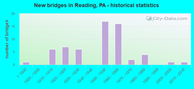
- New bridges - historical statistics
- 1Before 1900
- 61910-1919
- 71920-1929
- 61930-1939
- 171950-1959
- 161960-1969
- 21970-1979
- 41980-1989
- 12000-2009
- 12010-2019
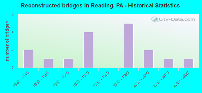
- Reconstructed bridges - Historical Statistics
- 21940-1949
- 11950-1959
- 11960-1969
- 41970-1979
- 01980-1989
- 51990-1999
- 22000-2009
- 12010-2019
- 12020-2022
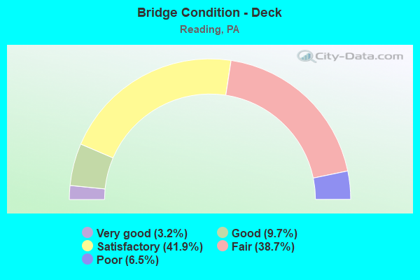
- Bridge Condition - Deck
- 3.2%Very good
- 9.7%Good
- 41.9%Satisfactory
- 38.7%Fair
- 6.5%Poor
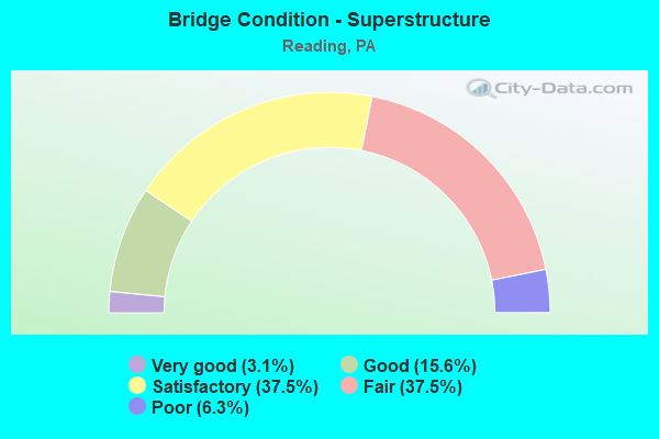
- Bridge Condition - Superstructure
- 3.1%Very good
- 15.6%Good
- 37.5%Satisfactory
- 37.5%Fair
- 6.3%Poor
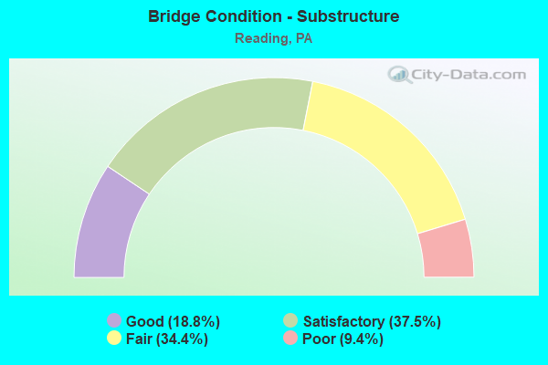
- Bridge Condition - Substructure
- 18.8%Good
- 37.5%Satisfactory
- 34.4%Fair
- 9.4%Poor
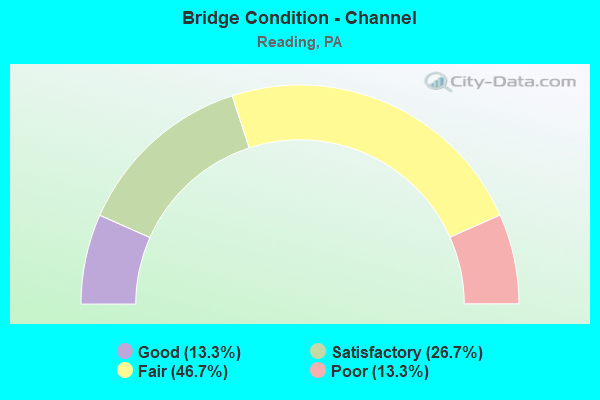
- Bridge Condition - Channel
- 13.3%Good
- 26.7%Satisfactory
- 46.7%Fair
- 13.3%Poor
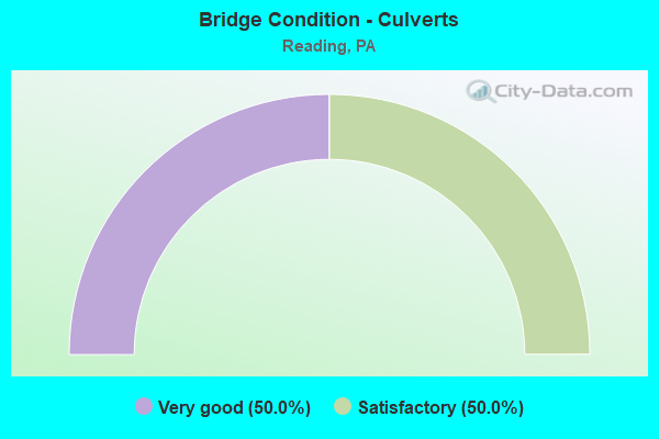
- Bridge Condition - Culverts
- 50.0%Very good
- 50.0%Satisfactory
Find on map >> Show street view
Structure Number: 477, Location: US422 INTERCHANGE (Lat: 40.324608, Lng: -75.933406), Route carried "under" structure: US 222B, Year Built: 1963, Structure Length: 0. m, Average Daily Traffic: 9,026 (year 2021), Truck Traffic: 4%, Features Intersected: SR 2005(LR 148), Facility Carried by Structure: SR 422(LR 793)
Minimum Vertical Clearance: 4.48m (14.70ft), Kilometerpoint: 0.000, Lanes on structure: 2, Lanes under structure: 4, Material/Design: Prestressed concrete, Design/Construction: Box Beam or Girders - Single/Spread, Length of Maximum Span: 20.7m (67.9ft)
Find on map >> Show street view
Structure Number: 477, Location: US422 INTERCHANGE (Lat: 40.324608, Lng: -75.933406), Route carried "under" structure: US 222B, Year Built: 1963, Structure Length: 0. m, Average Daily Traffic: 9,028 (year 2021), Truck Traffic: 4%, Features Intersected: SR 2005(LR 148), Facility Carried by Structure: SR 422(LR 793)
Minimum Vertical Clearance: 4.51m (14.80ft), Kilometerpoint: 0.000, Lanes on structure: 2, Lanes under structure: 4, Material/Design: Prestressed concrete, Design/Construction: Box Beam or Girders - Single/Spread, Length of Maximum Span: 20.7m (67.9ft)
Find on map >> Show street view
Structure Number: 4773, Location: US422 INTERCHANGE (Lat: 40.324122, Lng: -75.933597), Route carried "under" structure: US 222B, Year Built: 1963, Structure Length: 0. m, Average Daily Traffic: 11,309 (year 2022), Truck Traffic: 7%, Features Intersected: SR 3222(LR148), Facility Carried by Structure: SR 422(LR 793) EB
Minimum Vertical Clearance: 5.18m (16.99ft), Kilometerpoint: 5.671, Lanes on structure: 2, Lanes under structure: 4, Material/Design: Prestressed concrete, Design/Construction: Stringer/Multi-beam, Length of Maximum Span: 25.3m (83.0ft)
Find on map >> Show street view
Structure Number: 4773, Location: US422 INTERCHANGE (Lat: 40.324122, Lng: -75.933597), Route carried "under" structure: US 222B, Year Built: 1963, Structure Length: 0. m, Average Daily Traffic: 11,802 (year 2022), Truck Traffic: 8%, Features Intersected: SR 3222(LR148), Facility Carried by Structure: SR 422(LR 793) EB
Minimum Vertical Clearance: 5.06m (16.60ft), Kilometerpoint: 5.675, Lanes on structure: 2, Lanes under structure: 4, Material/Design: Prestressed concrete, Design/Construction: Stringer/Multi-beam, Length of Maximum Span: 25.3m (83.0ft)
Find on map >> Show street view
Structure Number: 4781, Location: PA12-US222/422 INTERCHNGE (Lat: 40.358417, Lng: -75.944425), Route carried "under" structure: City street , Year Built: 1951, Structure Length: 0. m, Average Daily Traffic: 50 (year 1994), Truck Traffic: 5%, Features Intersected: 222 SB,422 WB,CK,CITY ST, Facility Carried by Structure: PA 12 (LR 06150)
Minimum Vertical Clearance: 4.42m (14.50ft), Kilometerpoint: 0.000, Lanes on structure: 4, Lanes under structure: 2, Material/Design: Steel continuous, Design/Construction: Stringer/Multi-beam, Length of Maximum Span: 51.8m (169.9ft)
Find on map >> Show street view
Structure Number: 4781, Location: PA12-US222/422 INTERCHNGE (Lat: 40.358417, Lng: -75.944425), Route carried "under" structure: US 222, Year Built: 1951, Structure Length: 0. m, Average Daily Traffic: 31,275 (year 2022), Truck Traffic: 10%, Features Intersected: 222 SB,422 WB,CK,CITY ST, Facility Carried by Structure: PA 12 (LR 06150)
Minimum Vertical Clearance: 5.39m (17.68ft), Kilometerpoint: 14.687, Lanes on structure: 4, Lanes under structure: 2, Material/Design: Steel continuous, Design/Construction: Stringer/Multi-beam, Length of Maximum Span: 51.8m (169.9ft)
Find on map >> Show street view
Structure Number: 4781, Location: PA12-US222/422 INTERCHNGE (Lat: 40.358417, Lng: -75.944425), Route carried "under" structure: US 222, Year Built: 1951, Structure Length: 0. m, Average Daily Traffic: 29,857 (year 2022), Truck Traffic: 11%, Features Intersected: 222 SB,422 WB,CK,CITY ST, Facility Carried by Structure: PA 12 (LR 06150)
Minimum Vertical Clearance: 5.46m (17.91ft), Kilometerpoint: 14.677, Lanes on structure: 4, Lanes under structure: 2, Material/Design: Steel continuous, Design/Construction: Stringer/Multi-beam, Length of Maximum Span: 51.8m (169.9ft)
Find on map >> Show street view
Structure Number: 4782, Location: WARREN ST.BYPASS (Lat: 40.370861, Lng: -75.928675), Route carried "under" structure: City street , Year Built: 1957, Structure Length: 0. m, Average Daily Traffic: 300 (year 1994), Truck Traffic: 1%, Features Intersected: SCHUYLKILL R.;RIVER RD., Facility Carried by Structure: PA 12(LR 784)
Minimum Vertical Clearance: 4.15m (13.62ft), Kilometerpoint: 0.000, Lanes on structure: 4, Lanes under structure: 2, Material/Design: Steel continuous, Design/Construction: Girder and Floorbeam System, Length of Maximum Span: 71.3m (233.9ft)
Find on map >> Show street view
Structure Number: 4784, Location: WARREN ST.BYPASS (Lat: 40.368556, Lng: -75.935414), Route carried "under" structure: ServiceOther road , Year Built: 1957, Structure Length: 0. m, Average Daily Traffic: 333 (year 1994), Truck Traffic: 5%, Features Intersected: PRIVATE RDS(CAR-TECH.), Facility Carried by Structure: SR 12(LR 784)
Minimum Vertical Clearance: 5.09m (16.70ft), Kilometerpoint: 0.000, Lanes on structure: 2, Lanes under structure: 2, Material/Design: Steel continuous, Design/Construction: Stringer/Multi-beam, Length of Maximum Span: 17.4m (57.1ft)
Find on map >> Show street view
Structure Number: 4784, Location: WARREN ST.BYPASS (Lat: 40.368556, Lng: -75.935414), Route carried "under" structure: ServiceOther road , Year Built: 1957, Structure Length: 0. m, Average Daily Traffic: 33 (year 1994), Features Intersected: PRIVATE RDS(CAR-TECH.), Facility Carried by Structure: SR 12(LR 784)
Minimum Vertical Clearance: 4.57m (14.99ft), Kilometerpoint: 0.000, Lanes on structure: 2, Lanes under structure: 2, Material/Design: Steel continuous, Design/Construction: Stringer/Multi-beam, Length of Maximum Span: 17.4m (57.1ft)
Find on map >> Show street view
Structure Number: 4785, Location: PA61 INTERCHANGE (Lat: 40.369417, Lng: -75.932694), Route carried "under" structure: State highway 61, Year Built: 1957, Structure Length: 0. m, Average Daily Traffic: 12,707 (year 2022), Truck Traffic: 6%, Features Intersected: SR 61(LR 160), Facility Carried by Structure: SR 12(LR 784)
Minimum Vertical Clearance: 4.72m (15.49ft), Kilometerpoint: 2.589, Lanes on structure: 4, Lanes under structure: 4, Material/Design: Steel, Design/Construction: Stringer/Multi-beam, Length of Maximum Span: 26.8m (87.9ft)
Find on map >> Show street view
Structure Number: 4785, Location: PA61 INTERCHANGE (Lat: 40.369417, Lng: -75.932694), Route carried "under" structure: State highway 61, Year Built: 1957, Structure Length: 0. m, Average Daily Traffic: 12,543 (year 2022), Truck Traffic: 6%, Features Intersected: SR 61(LR 160), Facility Carried by Structure: SR 12(LR 784)
Minimum Vertical Clearance: 4.45m (14.60ft), Kilometerpoint: 2.588, Lanes on structure: 4, Lanes under structure: 4, Material/Design: Steel, Design/Construction: Stringer/Multi-beam, Length of Maximum Span: 26.8m (87.9ft)
Find on map >> Show street view
Structure Number: 4851, Location: READING BYPASS (Lat: 40.313058, Lng: -75.921669), Route carried "under" structure: ServiceOther road , Year Built: 1963, Structure Length: 0. m, Average Daily Traffic: 100 (year 2004), Truck Traffic: 1%, Features Intersected: BRENTWOOD DRIVE, Facility Carried by Structure: US 422(LR 793)
Minimum Vertical Clearance: 5.94m (19.49ft), Kilometerpoint: 0.000, Lanes on structure: 4, Lanes under structure: 2, Material/Design: Steel continuous, Design/Construction: Stringer/Multi-beam, Length of Maximum Span: 14.0m (45.9ft)
Find on map >> Show street view
Structure Number: 5035, Location: BINGAMAN ST BRIDGE (Lat: 40.326150, Lng: -75.932333), Route carried "under" structure: City street , Year Built: 1920, Structure Length: 0. m, Average Daily Traffic: 1,250 (year 1996), Truck Traffic: 5%, Features Intersected: NORFOLK SOUTHERN RR, Facility Carried by Structure: SR 2005 (LR 148)
Minimum Vertical Clearance: 4.60m (15.09ft), Kilometerpoint: 0.000, Lanes on structure: 4, Lanes under structure: 5, Material/Design: Concrete, Design/Construction: Arch - Deck, Length of Maximum Span: 34.7m (113.8ft)
Find on map >> Show street view
Structure Number: 5059, Location: LINDBERGH VIADUCT (Lat: 40.331347, Lng: -75.898969), Route carried "under" structure: City street LOCL, Year Built: 1927, Structure Length: 0. m, Average Daily Traffic: 450 (year 1994), Truck Traffic: 5%, Features Intersected: MINERAL SPRINGS CR.,STS., Facility Carried by Structure: US 422 BUS(LR 146)
Minimum Vertical Clearance: 11.19m (36.71ft), Kilometerpoint: 0.000, Lanes on structure: 4, Lanes under structure: 4, Material/Design: Concrete, Design/Construction: Arch - Deck, Length of Maximum Span: 25.3m (83.0ft)
Find on map >> Show street view
Structure Number: 5079, Location: PRICETOWN ROAD OVER 13TH (Lat: 40.370142, Lng: -75.911228), Route carried "under" structure: City street , Year Built: 1980, Structure Length: 0. m, Average Daily Traffic: 5,600 (year 1994), Truck Traffic: 1%, Features Intersected: 13 TH STREET, Facility Carried by Structure: PA 12 (LR 784)
Minimum Vertical Clearance: 4.42m (14.50ft), Kilometerpoint: 0.000, Lanes on structure: 6, Lanes under structure: 2, Material/Design: Prestressed concrete, Design/Construction: Stringer/Multi-beam, Length of Maximum Span: 30.5m (100.1ft)
Find on map >> Show street view
Structure Number: 5083, Location: NORTH OF PRICETOWN ROAD (Lat: 40.376306, Lng: -75.899364), Route carried "under" structure: City street , Year Built: 1978, Structure Length: 0. m, Average Daily Traffic: 4,452 (year 1996), Truck Traffic: 1%, Features Intersected: T-413(SPRING VALLEY RD), Facility Carried by Structure: SR 12 (LR 784 WB)
Minimum Vertical Clearance: 5.64m (18.50ft), Kilometerpoint: 0.000, Lanes on structure: 3, Lanes under structure: 3, Material/Design: Prestressed concrete, Design/Construction: Box Beam or Girders - Multiple, Length of Maximum Span: 31.7m (104.0ft)
Find on map >> Show street view
Structure Number: 5221, Location: PENN ST BRIDGE (Lat: 40.335378, Lng: -75.936258), Route carried "under" structure: City street LOCL, Year Built: 1913, Structure Length: 0. m, Average Daily Traffic: 2,200 (year 1996), Features Intersected: SCH.RIVER;STREETS;NOR/FO, Facility Carried by Structure: US422BUS (LR 149)
Minimum Vertical Clearance: 6.52m (21.39ft), Kilometerpoint: 0.000, Lanes on structure: 4, Lanes under structure: 2, Material/Design: Concrete, Design/Construction: Arch - Deck, Length of Maximum Span: 33.5m (109.9ft)
Find on map >> Show street view
Structure Number: 5487, Location: BUTTONWOOD ST. - READING (Lat: 40.339119, Lng: -75.943206), Route carried "under" structure: US 422, Year Built: 1932, Structure Length: 0. m, Average Daily Traffic: 41,746 (year 2022), Truck Traffic: 5%, Features Intersected: SCH.R.,422,NSRC,RIV.RD., Facility Carried by Structure: BUTTONWOOD STREET
Minimum Vertical Clearance: 5.21m (17.09ft), Kilometerpoint: 27.504, Lanes on structure: 3, Lanes under structure: 3, Material/Design: Concrete, Design/Construction: Arch - Deck, Length of Maximum Span: 37.5m (123.0ft)
Find on map >> Show street view
Structure Number: 5487, Location: BUTTONWOOD ST. - READING (Lat: 40.339119, Lng: -75.943206), Route carried "under" structure: City street , Year Built: 1932, Structure Length: 0. m, Average Daily Traffic: 10 (year 1990), Features Intersected: SCH.R.,422,NSRC,RIV.RD., Facility Carried by Structure: BUTTONWOOD STREET
Minimum Vertical Clearance: 4.57m (14.99ft), Kilometerpoint: 0.000, Lanes on structure: 3, Lanes under structure: 2, Material/Design: Concrete, Design/Construction: Arch - Deck, Length of Maximum Span: 37.5m (123.0ft)
Find on map >> Show street view
Structure Number: 5487, Location: BUTTONWOOD ST. - READING (Lat: 40.339119, Lng: -75.943206), Route carried "under" structure: US 422, Year Built: 1932, Structure Length: 0. m, Average Daily Traffic: 41,787 (year 2022), Truck Traffic: 7%, Features Intersected: SCH.R.,422,NSRC,RIV.RD., Facility Carried by Structure: BUTTONWOOD STREET
Minimum Vertical Clearance: 5.33m (17.49ft), Kilometerpoint: 27.507, Lanes on structure: 3, Lanes under structure: 3, Material/Design: Concrete, Design/Construction: Arch - Deck, Length of Maximum Span: 37.5m (123.0ft)
Find on map >> Show street view
Structure Number: 5518, Location: CITY/BOROUGH LINE (Lat: 40.351128, Lng: -75.956872), Route carried "under" structure: City street , Year Built: 1959, Structure Length: 0. m, Average Daily Traffic: 35 (year 2002), Features Intersected: TULPEHOCKEN CREEK;STREET, Facility Carried by Structure: RAMP SR 8042
Minimum Vertical Clearance: 5.15m (16.90ft), Kilometerpoint: 0.000, Lanes on structure: 1, Lanes under structure: 2, Material/Design: Steel continuous, Design/Construction: Stringer/Multi-beam, Length of Maximum Span: 30.5m (100.1ft)