Bridge Statistics for Red Wing, Minnesota (MN)
Condition, Traffic, Stress, Structural Evaluation, Project Costs
- New bridges - historical statistics
- 31900-1909
- 11920-1929
- 11930-1939
- 41940-1949
- 31950-1959
- 31960-1969
- 71970-1979
- 181980-1989
- 101990-1999
- 32000-2009
- 102010-2019
- 12020-2022
- Bridge Condition - Deck
- 21.6%Very good
- 54.1%Good
- 16.2%Satisfactory
- 5.4%Fair
- 2.7%Poor
- Bridge Condition - Superstructure
- 2.7%Excellent
- 35.1%Very good
- 40.5%Good
- 16.2%Satisfactory
- 5.4%Fair
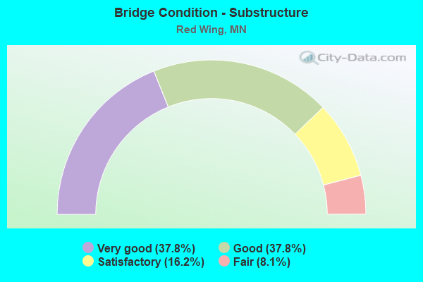
- Bridge Condition - Substructure
- 37.8%Very good
- 37.8%Good
- 16.2%Satisfactory
- 8.1%Fair
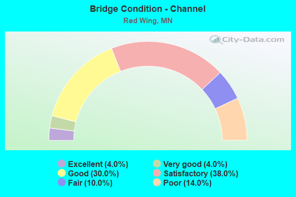
- Bridge Condition - Channel
- 4.0%Excellent
- 4.0%Very good
- 30.0%Good
- 38.0%Satisfactory
- 10.0%Fair
- 14.0%Poor
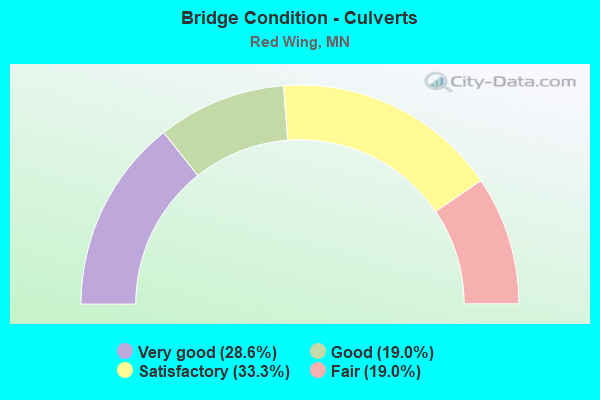
- Bridge Condition - Culverts
- 28.6%Very good
- 19.0%Good
- 33.3%Satisfactory
- 19.0%Fair
Find on map >> Show street view
Structure Number: 91323, Location: 0.1 MI E OF JCT CSAH 1 (Lat: 44.543450, Lng: -92.573364), Route carried "on" structure: County highway 66, Year Built: 1975, Status: Open, Structure Length: 1.01m (3.31ft), Average Daily Traffic: 7,500 (year 2015), Average Future Daily Traffic: 7,500 (year 2039), Features Intersected: TROUT BROOK
Minimum Vertical Clearance: 30+ m (98+ ft), Kilometerpoint: 0.000, Lanes on structure: 2, Owner: County Highway Agency, Approaching Roadway Width: 11.0m (36.1ft), Material/Design: Concrete, Design/Construction: Culvert, Number Of Spans In Main Unit: 3, Length of Maximum Span: 3.0m (9.8ft)
Condition: Channel: Fair, Culverts: Good, Operating Rating: 53.9 metric tons, Method Used To Determine Operating Rating: Field evaluation and documented engineering judgment, Inventory Rating: 35.9 metric tons, Method Used To Determine Inventory Rating: Field evaluation and documented engineering judgment, Structural Evaluation: Better than present minimum criteria, Waterway Adequacy: Better than present minimum criteria, Approach Roadway Alignment: Equal to present desirable criteria, Designated Inspection Frequency: Every 24 months, Inspection Date: November 2020
Find on map >> Show street view
Structure Number: 91944, Location: 0.6 MI S OF JCT TH 61 (Lat: 44.585781, Lng: -92.687522), Route carried "on" structure: County highway 18, Year Built: 1986, Status: Open, Structure Length: 1.22m (4.00ft), Average Daily Traffic: 60 (year 1986), Average Future Daily Traffic: 60 (year 2029), Design Load: HS 20, Features Intersected: STREAM
Minimum Vertical Clearance: 30+ m (98+ ft), Kilometerpoint: 0.000, Lanes on structure: 2, Owner: Town or Township Highway Agency, Approaching Roadway Width: 8.5m (27.9ft), Material/Design: Concrete, Design/Construction: Culvert, Number Of Spans In Main Unit: 3, Length of Maximum Span: 3.0m (9.8ft)
Condition: Channel: Fair, Culverts: Satisfactory, Operating Rating: 58.8 metric tons, Method Used To Determine Operating Rating: Assigned rating based on Load Factor Design (LFD) reported in metric tons, Inventory Rating: 39.2 metric tons, Method Used To Determine Inventory Rating: Assigned rating based on Load Factor Design (LFD) reported in metric tons, Structural Evaluation: Equal to present minimum criteria, Waterway Adequacy: Superior to present desirable criteria, Approach Roadway Alignment: Equal to present desirable criteria, Designated Inspection Frequency: Every 24 months, Inspection Date: September 2021
Find on map >> Show street view
Structure Number: 93214, Location: 0.7 MI S OF JCT TH 19 (Lat: 44.523422, Lng: -92.661850), Route carried "on" structure: County highway 6, Year Built: 1976, Status: Open, Structure Length: 1.13m (3.71ft), Average Daily Traffic: 1,200 (year 2011), Average Future Daily Traffic: 1,200 (year 2039), Design Load: HS 20, Features Intersected: SPRING CREEK
Minimum Vertical Clearance: 30+ m (98+ ft), Kilometerpoint: 0.000, Lanes on structure: 2, Owner: County Highway Agency, Approaching Roadway Width: 8.5m (27.9ft), Skew: 4 degrees, Material/Design: Concrete, Design/Construction: Culvert, Number Of Spans In Main Unit: 3, Length of Maximum Span: 4.3m (14.1ft)
Condition: Channel: Poor, Culverts: Good, Operating Rating: 53.9 metric tons, Method Used To Determine Operating Rating: Assigned ratings based on Allowable Stress Design (ASD) reported in metric tons, Inventory Rating: 35.9 metric tons, Method Used To Determine Inventory Rating: Assigned ratings based on Allowable Stress Design (ASD) reported in metric tons, Structural Evaluation: Better than present minimum criteria, Waterway Adequacy: Equal to present desirable criteria, Approach Roadway Alignment: Equal to present desirable criteria, Designated Inspection Frequency: Every 24 months, Inspection Date: September 2021
Find on map >> Show street view
Structure Number: 93215, Location: 0.9 MI S OF JCT TH 19 (Lat: 44.518494, Lng: -92.661697), Route carried "on" structure: County highway 6, Year Built: 1976, Status: Open, Structure Length: 0.97m (3.18ft), Average Daily Traffic: 1,200 (year 2011), Average Future Daily Traffic: 1,200 (year 2039), Design Load: HS 20, Features Intersected: SPRING CREEK
Minimum Vertical Clearance: 30+ m (98+ ft), Kilometerpoint: 0.000, Lanes on structure: 2, Owner: County Highway Agency, Approaching Roadway Width: 8.5m (27.9ft), Skew: 4 degrees, Material/Design: Concrete, Design/Construction: Culvert, Number Of Spans In Main Unit: 3, Length of Maximum Span: 3.5m (11.5ft)
Condition: Channel: Poor, Culverts: Satisfactory, Operating Rating: 53.9 metric tons, Method Used To Determine Operating Rating: Assigned ratings based on Allowable Stress Design (ASD) reported in metric tons, Inventory Rating: 35.9 metric tons, Method Used To Determine Inventory Rating: Assigned ratings based on Allowable Stress Design (ASD) reported in metric tons, Structural Evaluation: Equal to present minimum criteria, Waterway Adequacy: Equal to present desirable criteria, Approach Roadway Alignment: Equal to present desirable criteria, Designated Inspection Frequency: Every 24 months, Inspection Date: September 2021
Find on map >> Show street view
Structure Number: 93773, Location: 0.02 MI E OF JCT TH 61 (Lat: 44.567347, Lng: -92.515853), Route carried "on" structure: Other road , Year Built: 1986, Status: Open, Structure Length: 14.77m (48.46ft), Average Daily Traffic: 200 (year 1986), Average Future Daily Traffic: 200 (year 2029), Design Load: HS 20, Features Intersected: CP RAIL, Facility Carried by Structure: PRIVATE RD
Minimum Vertical Clearance: 30+ m (98+ ft), Kilometerpoint: 0.000, Lanes on structure: 2, Owner: Private, Approaching Roadway Width: 11.0m (36.1ft), Material/Design: Prestressed concrete, Design/Construction: Tee Beam, Number Of Spans In Main Unit: 6, Length of Maximum Span: 25.9m (85.0ft), Curb-To-Curb Width: 8.1m (26.6ft), Out-to-Out Width: 9.1m (29.9ft)
Condition: Deck: Good, Superstructure: Satisfactory, Substructure: Good, Operating Rating: 44.1 metric tons, Method Used To Determine Operating Rating: Load Factor (LF), Inventory Rating: 30.8 metric tons, Method Used To Determine Inventory Rating: Load Factor (LF), Structural Evaluation: Equal to present minimum criteria, Deck Geometry: Somewhat better than minimum adequacy, Underclear: Better than present minimum criteria, Approach Roadway Alignment: Meets minimum limits, Designated Inspection Frequency: Every 24 months, Inspection Date: April 2020, Deck Structure Type: Concrete Cast-file-Place, Wearing Surface/Protective System: Wearing Surface: Low Slump Concrete, Deck Protection: Epoxy Coated Reinforcing
Find on map >> Show street view
Structure Number: 9449, Location: 0.8 MI SE OF JCT TH 58 (Lat: 44.567519, Lng: -92.519897), Route carried "on" structure: US 61, Year Built: 1962, Status: Open, Structure Length: 4.06m (13.32ft), Average Daily Traffic: 8,000 (year 2019), Truck Traffic: 7%, Average Future Daily Traffic: 8,000 (year 2039), Design Load: HS 20, Features Intersected: E 5TH ST
Minimum Vertical Clearance: 30+ m (98+ ft), Kilometerpoint: 0.000, Lanes on structure: 4, Lanes under structure: 2, Base Highway Network: Yes, Owner: State Highway Agency, Approaching Roadway Width: 20.7m (67.9ft), Skew: 23 degrees, Material/Design: Prestressed concrete, Design/Construction: Stringer/Multi-beam, Number Of Spans In Main Unit: 3, Length of Maximum Span: 16.2m (53.1ft), Curb-To-Curb Width: 16.5m (54.1ft), Out-to-Out Width: 19.4m (63.6ft)
Condition: Deck: Satisfactory, Superstructure: Satisfactory, Substructure: Satisfactory, Operating Rating: 58.1 metric tons, Method Used To Determine Operating Rating: Load Factor (LF), Inventory Rating: 36.9 metric tons, Method Used To Determine Inventory Rating: Load Factor (LF), Structural Evaluation: Equal to present minimum criteria, Deck Geometry: Meets minimum limits, Underclear: Somewhat better than minimum adequacy, Approach Roadway Alignment: Equal to present desirable criteria, Length Of Structure Improvement: 1.49m (4.89ft), Designated Inspection Frequency: Every 24 months, Inspection Date: September 2021, Bridge Improvement Cost: $949,000,000, Roadway Improvement Cost: $13,000,000, Total Project Cost: $195,000,000, Deck Structure Type: Concrete Cast-file-Place, Wearing Surface/Protective System: Wearing Surface: Low Slump Concrete
Find on map >> Show street view
Structure Number: 9544, Location: 1.9 MI N OF JCT TH 61 (Lat: 44.621369, Lng: -92.671775), Route carried "on" structure: County highway 18, Year Built: 1987, Status: Open, Structure Length: 1.30m (4.27ft), Average Daily Traffic: 6,900 (year 2015), Average Future Daily Traffic: 6,900 (year 2039), Design Load: HS 20, Features Intersected: STREAM
Minimum Vertical Clearance: 30+ m (98+ ft), Kilometerpoint: 0.000, Lanes on structure: 2, Owner: County Highway Agency, Approaching Roadway Width: 12.2m (40.0ft), Material/Design: Concrete, Design/Construction: Culvert, Number Of Spans In Main Unit: 3, Length of Maximum Span: 3.9m (12.8ft)
Condition: Channel: Satisfactory, Culverts: Very good, Operating Rating: 53.9 metric tons, Method Used To Determine Operating Rating: Assigned ratings based on Allowable Stress Design (ASD) reported in metric tons, Inventory Rating: 35.9 metric tons, Method Used To Determine Inventory Rating: Assigned ratings based on Allowable Stress Design (ASD) reported in metric tons, Structural Evaluation: Equal to present desirable criteria, Waterway Adequacy: Superior to present desirable criteria, Approach Roadway Alignment: Equal to present desirable criteria, Designated Inspection Frequency: Every 48 months, Inspection Date: November 2018
Find on map >> Show street view
Structure Number: 97039, Location: 0.1 MI N OF JCT TH 61 (Lat: 44.592400, Lng: -92.669000), Route carried "on" structure: County highway 18, Year Built: 1991, Status: Open, Structure Length: 0.66m (2.17ft), Average Daily Traffic: 6,900 (year 2015), Average Future Daily Traffic: 6,900 (year 2039), Design Load: HS 25 or greater, Features Intersected: STREAM
Minimum Vertical Clearance: 30+ m (98+ ft), Kilometerpoint: 0.000, Lanes on structure: 3, Owner: County Highway Agency, Approaching Roadway Width: 14.6m (47.9ft), Material/Design: Concrete, Design/Construction: Culvert, Number Of Spans In Main Unit: 2, Length of Maximum Span: 2.4m (7.9ft)
Condition: Channel: Good, Culverts: Good, Operating Rating: 58.8 metric tons, Method Used To Determine Operating Rating: Assigned rating based on Load Factor Design (LFD) reported in metric tons, Inventory Rating: 39.2 metric tons, Method Used To Determine Inventory Rating: Assigned rating based on Load Factor Design (LFD) reported in metric tons, Structural Evaluation: Better than present minimum criteria, Waterway Adequacy: Equal to present desirable criteria, Approach Roadway Alignment: Equal to present desirable criteria, Designated Inspection Frequency: Every 48 months, Inspection Date: November 2018
Find on map >> Show street view
Structure Number: 97746, Location: 1.6 MI NW OF JCT TH 19 (Lat: 44.585378, Lng: -92.658242), Route carried "on" structure: US 61, Year Built: 1994, Status: Open, Structure Length: 1.26m (4.13ft), Average Daily Traffic: 17,500 (year 2019), Truck Traffic: 8%, Average Future Daily Traffic: 16,300 (year 2039), Design Load: HS 25 or greater, Features Intersected: DITCH
Minimum Vertical Clearance: 30+ m (98+ ft), Kilometerpoint: 0.000, Lanes on structure: 6, Base Highway Network: Yes, Owner: State Highway Agency, Approaching Roadway Width: 36.6m (120.1ft), Skew: 13 degrees, Material/Design: Concrete, Design/Construction: Culvert, Number Of Spans In Main Unit: 3, Length of Maximum Span: 3.7m (12.1ft)
Condition: Channel: Satisfactory, Culverts: Satisfactory, Operating Rating: 53.9 metric tons, Method Used To Determine Operating Rating: Assigned rating based on Load Factor Design (LFD) reported in metric tons, Inventory Rating: 35.9 metric tons, Method Used To Determine Inventory Rating: Assigned rating based on Load Factor Design (LFD) reported in metric tons, Structural Evaluation: Equal to present minimum criteria, Waterway Adequacy: Superior to present desirable criteria, Approach Roadway Alignment: Equal to present desirable criteria, Designated Inspection Frequency: Every 24 months, Inspection Date: September 2021
Find on map >> Show street view
Structure Number: 97747, Location: 2.3 MI NW OF JCT TH 19 (Lat: 44.591839, Lng: -92.668664), Route carried "on" structure: US 61, Year Built: 1994, Status: Open, Structure Length: 0.99m (3.25ft), Average Daily Traffic: 17,500 (year 2019), Truck Traffic: 8%, Average Future Daily Traffic: 16,300 (year 2039), Design Load: HS 25 or greater, Features Intersected: DITCH
Minimum Vertical Clearance: 30+ m (98+ ft), Kilometerpoint: 0.000, Lanes on structure: 7, Base Highway Network: Yes, Owner: State Highway Agency, Approaching Roadway Width: 36.6m (120.1ft), Skew: 14 degrees, Material/Design: Concrete, Design/Construction: Culvert, Number Of Spans In Main Unit: 2, Length of Maximum Span: 4.3m (14.1ft)
Condition: Channel: Satisfactory, Culverts: Satisfactory, Operating Rating: 53.9 metric tons, Method Used To Determine Operating Rating: Assigned rating based on Load Factor Design (LFD) reported in metric tons, Inventory Rating: 35.9 metric tons, Method Used To Determine Inventory Rating: Assigned rating based on Load Factor Design (LFD) reported in metric tons, Structural Evaluation: Equal to present minimum criteria, Waterway Adequacy: Superior to present desirable criteria, Approach Roadway Alignment: Equal to present desirable criteria, Designated Inspection Frequency: Every 24 months, Inspection Date: September 2021
Find on map >> Show street view
Structure Number: L0358, Location: 0.8 MI S OF JCT CSAH 66 (Lat: 44.533619, Lng: -92.584756), Route carried "on" structure: County highway 1, Year Built: 1948, Status: Open, Structure Length: 0.68m (2.23ft), Average Daily Traffic: 1,350 (year 2015), Average Future Daily Traffic: 1,350 (year 2039), Features Intersected: STREAM
Minimum Vertical Clearance: 30+ m (98+ ft), Kilometerpoint: 0.000, Lanes on structure: 2, Owner: County Highway Agency, Approaching Roadway Width: 7.9m (25.9ft), Material/Design: Concrete, Design/Construction: Culvert, Number Of Spans In Main Unit: 2, Length of Maximum Span: 3.0m (9.8ft)
Condition: Channel: Good, Culverts: Very good, Operating Rating: 53.9 metric tons, Method Used To Determine Operating Rating: Assigned ratings based on Allowable Stress Design (ASD) reported in metric tons, Inventory Rating: 35.9 metric tons, Method Used To Determine Inventory Rating: Assigned ratings based on Allowable Stress Design (ASD) reported in metric tons, Structural Evaluation: Equal to present desirable criteria, Waterway Adequacy: Better than present minimum criteria, Approach Roadway Alignment: Equal to present minimum criteria, Length Of Structure Improvement: 0.34m (1.12ft), Designated Inspection Frequency: Every 24 months, Inspection Date: September 2021, Bridge Improvement Cost: $71,000,000, Roadway Improvement Cost: $8,000,000, Total Project Cost: $130,000,000
Find on map >> Show street view
Structure Number: L0487, Location: 1.2 MI NE OF JCT TH 61 (Lat: 44.613211, Lng: -92.695711), Route carried "on" structure: County highway 19, Year Built: 1900, Status: Open, Structure Length: 0.68m (2.23ft), Average Daily Traffic: 330 (year 2015), Average Future Daily Traffic: 330 (year 2039), Features Intersected: STREAM
Minimum Vertical Clearance: 30+ m (98+ ft), Kilometerpoint: 0.000, Lanes on structure: 2, Owner: County Highway Agency, Approaching Roadway Width: 9.1m (29.9ft), Skew: 4 degrees, Material/Design: Concrete, Design/Construction: Culvert, Number Of Spans In Main Unit: 2, Length of Maximum Span: 3.1m (10.2ft)
Condition: Channel: Good, Culverts: Satisfactory, Operating Rating: 53.9 metric tons, Method Used To Determine Operating Rating: Assigned ratings based on Allowable Stress Design (ASD) reported in metric tons, Inventory Rating: 35.9 metric tons, Method Used To Determine Inventory Rating: Assigned ratings based on Allowable Stress Design (ASD) reported in metric tons, Structural Evaluation: Equal to present minimum criteria, Waterway Adequacy: Equal to present minimum criteria, Approach Roadway Alignment: Somewhat better than minimum adequacy, Length Of Structure Improvement: 0.34m (1.12ft), Designated Inspection Frequency: Every 48 months, Inspection Date: September 2021, Bridge Improvement Cost: $64,000,000, Roadway Improvement Cost: $3,000,000, Total Project Cost: $48,000,000
Find on map >> Show street view
Structure Number: L0491, Location: 1.6 MI NE OF JCT TH 61 (Lat: 44.610958, Lng: -92.689225), Route carried "on" structure: County highway 19, Year Built: 1900, Status: Posted for load, Structure Length: 0.71m (2.33ft), Average Daily Traffic: 330 (year 2015), Average Future Daily Traffic: 330 (year 2039), Features Intersected: STREAM
Minimum Vertical Clearance: 30+ m (98+ ft), Kilometerpoint: 0.000, Lanes on structure: 2, Owner: County Highway Agency, Approaching Roadway Width: 9.1m (29.9ft), Skew: 4 degrees, Material/Design: Concrete, Design/Construction: Culvert, Number Of Spans In Main Unit: 1, Length of Maximum Span: 6.5m (21.3ft)
Condition: Channel: Good, Culverts: Fair, Operating Rating: 35.9 metric tons, Method Used To Determine Operating Rating: Field evaluation and documented engineering judgment, Inventory Rating: 26.1 metric tons, Method Used To Determine Inventory Rating: Field evaluation and documented engineering judgment, Structural Evaluation: Somewhat better than minimum adequacy, Waterway Adequacy: Somewhat better than minimum adequacy, Approach Roadway Alignment: Somewhat better than minimum adequacy, Bridge Posting: Required (Relationship of Operating Rating to Maximum Legal Load: 10.0 - 19.9% below), Length Of Structure Improvement: 0.34m (1.12ft), Designated Inspection Frequency: Every 24 months, Inspection Date: September 2021, Bridge Improvement Cost: $67,000,000, Roadway Improvement Cost: $4,000,000, Total Project Cost: $73,000,000
Find on map >> Show street view
Structure Number: L0558, Location: 1.6 MI N OF JCT TH 58 (Lat: 44.510136, Lng: -92.566258), Route carried "on" structure: County highway 36, Year Built: 1900, Status: Posted for load, Structure Length: 0.87m (2.85ft), Average Daily Traffic: 97 (year 1986), Average Future Daily Traffic: 97 (year 2029), Features Intersected: STREAM
Minimum Vertical Clearance: 30+ m (98+ ft), Kilometerpoint: 0.000, Lanes on structure: 2, Owner: Town or Township Highway Agency, Approaching Roadway Width: 6.1m (20.0ft), Skew: 2 degrees, Material/Design: Concrete, Design/Construction: Culvert, Number Of Spans In Main Unit: 2, Length of Maximum Span: 3.9m (12.8ft)
Condition: Channel: Poor, Culverts: Fair, Operating Rating: 29.4 metric tons, Method Used To Determine Operating Rating: Field evaluation and documented engineering judgment, Inventory Rating: 19.6 metric tons, Method Used To Determine Inventory Rating: Field evaluation and documented engineering judgment, Structural Evaluation: Somewhat better than minimum adequacy, Waterway Adequacy: Meets minimum limits, Approach Roadway Alignment: Equal to present minimum criteria, Bridge Posting: Required (Relationship of Operating Rating to Maximum Legal Load: 0.1 - 9.9% below), Designated Inspection Frequency: Every 24 months, Inspection Date: September 2020
Find on map >> Show street view
Structure Number: L6406, Location: 1.2 MI W OF JCT CSAH 1 (Lat: 44.492647, Lng: -92.645642), Route carried "on" structure: County highway 130, Year Built: 1984, Status: Open, Structure Length: 0.63m (2.07ft), Average Daily Traffic: 38 (year 1986), Average Future Daily Traffic: 38 (year 2029), Features Intersected: STREAM
Minimum Vertical Clearance: 30+ m (98+ ft), Kilometerpoint: 0.000, Lanes on structure: 2, Owner: Town or Township Highway Agency, Approaching Roadway Width: 6.7m (22.0ft), Material/Design: Steel, Design/Construction: Culvert, Number Of Spans In Main Unit: 2, Length of Maximum Span: 2.7m (8.9ft)
Condition: Channel: Poor, Culverts: Good, Operating Rating: 35.9 metric tons, Method Used To Determine Operating Rating: Assigned ratings based on Allowable Stress Design (ASD) reported in metric tons, Inventory Rating: 26.1 metric tons, Method Used To Determine Inventory Rating: Assigned ratings based on Allowable Stress Design (ASD) reported in metric tons, Structural Evaluation: Equal to present minimum criteria, Waterway Adequacy: Equal to present desirable criteria, Approach Roadway Alignment: Equal to present desirable criteria, Designated Inspection Frequency: Every 24 months, Inspection Date: September 2021
Find on map >> Show street view
Structure Number: 25019, Location: 1.7 MI SE OF JCT TH 19 (Lat: 44.573078, Lng: -92.606919), Route carried "under" structure: US 61, Year Built: 1986, Structure Length: 0. m, Average Daily Traffic: 16,400 (year 2019), Truck Traffic: 5%, Features Intersected: US 61, Facility Carried by Structure: PEDESTRIAN
Minimum Vertical Clearance: 5.40m (17.72ft), Kilometerpoint: 0.000, Lanes on structure: 4, Lanes under structure: 4, Material/Design: Steel continuous, Design/Construction: Stringer/Multi-beam, Length of Maximum Span: 40.2m (131.9ft)
Find on map >> Show street view
Structure Number: 25028, Location: 1.4 MI SE OF JCT TH 58 (Lat: 44.564719, Lng: -92.507317), Route carried "under" structure: City street 187, Year Built: 2014, Structure Length: 0. m, Average Daily Traffic: 50 (year 1977), Features Intersected: NYMPHARA LANE, Facility Carried by Structure: US 61
Minimum Vertical Clearance: 4.42m (14.50ft), Kilometerpoint: 0.000, Lanes under structure: 2, Material/Design: Prestressed concrete, Design/Construction: Stringer/Multi-beam, Length of Maximum Span: 21.0m (68.9ft)
Find on map >> Show street view
Structure Number: 25034, Location: 0.2 MI N OF JCT TH 58 (Lat: 44.568244, Lng: -92.531772), Route carried "under" structure: US 61, Year Built: 2019, Structure Length: 0. m, Average Daily Traffic: 8,000 (year 2019), Truck Traffic: 5%, Features Intersected: US 61, Facility Carried by Structure: US 63
Minimum Vertical Clearance: 5.85m (19.19ft), Kilometerpoint: 0.000, Lanes under structure: 4, Material/Design: Prestressed concrete, Design/Construction: Stringer/Multi-beam, Length of Maximum Span: 38.7m (127.0ft)
Find on map >> Show street view
Structure Number: 25035, Location: 0.1 MI SW OF JCT TH 61 (Lat: 44.567683, Lng: -92.531397), Route carried "under" structure: City street 285, Year Built: 2019, Structure Length: 0. m, Average Daily Traffic: 1 (year 2017), Features Intersected: BLUFF ST, Facility Carried by Structure: US 63
Minimum Vertical Clearance: 4.48m (14.70ft), Kilometerpoint: 0.000, Lanes under structure: 1, Material/Design: Prestressed concrete, Design/Construction: Stringer/Multi-beam, Length of Maximum Span: 9.3m (30.5ft)
Find on map >> Show street view
Structure Number: 6483, Location: 1.5 MI NW OF JCT TH 58 (Lat: 44.563319, Lng: -92.562981), Route carried "under" structure: City street 122, Year Built: 1952, Structure Length: 0. m, Average Daily Traffic: 2,950 (year 2003), Features Intersected: HAY CRK; WITHERS D, Facility Carried by Structure: US 61
Minimum Vertical Clearance: 6.89m (22.60ft), Kilometerpoint: 0.000, Lanes on structure: 4, Lanes under structure: 4, Material/Design: Steel continuous, Design/Construction: Stringer/Multi-beam, Length of Maximum Span: 42.7m (140.1ft)
Find on map >> Show street view
Structure Number: 9449, Location: 0.8 MI SE OF JCT TH 58 (Lat: 44.567519, Lng: -92.519897), Route carried "under" structure: City street 114, Year Built: 1962, Structure Length: 0. m, Average Daily Traffic: 50 (year 1977), Features Intersected: E 5TH ST, Facility Carried by Structure: US 61
Minimum Vertical Clearance: 4.76m (15.62ft), Kilometerpoint: 0.000, Lanes on structure: 4, Lanes under structure: 2, Material/Design: Prestressed concrete, Design/Construction: Stringer/Multi-beam, Length of Maximum Span: 16.2m (53.1ft)