Bridge Statistics for Richland, Washington (WA)
Condition, Traffic, Stress, Structural Evaluation, Project Costs
- National Bridge Inventory (NBI) Statistics
- 67Number of bridges
- 1,499ft / 457mTotal length
- $299,466,000Total costs
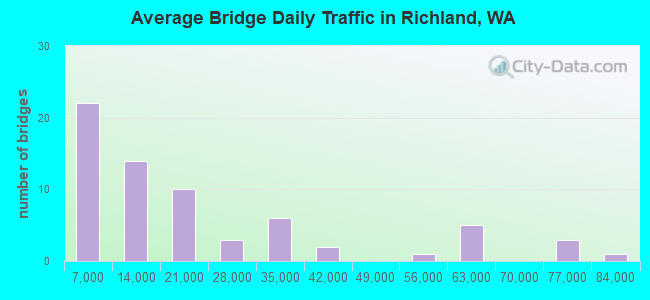
- 1,325,085Total average daily traffic
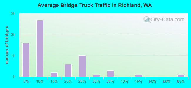
- 101,490Total average daily truck traffic
- National Bridge Inventory (NBI) Registered Bridges for Richland
- No street view available for this location
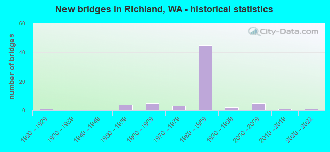
- New bridges - historical statistics
- 11920-1929
- 41950-1959
- 51960-1969
- 31970-1979
- 451980-1989
- 21990-1999
- 52000-2009
- 12010-2019
- 12020-2022
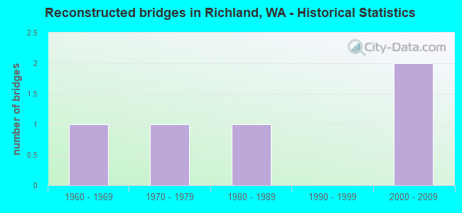
- Reconstructed bridges - Historical Statistics
- 11960-1969
- 11970-1979
- 11980-1989
- 01990-1999
- 22000-2009
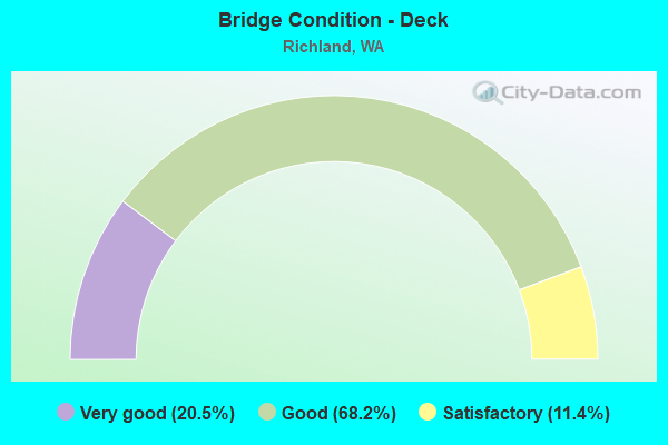
- Bridge Condition - Deck
- 20.5%Very good
- 68.2%Good
- 11.4%Satisfactory
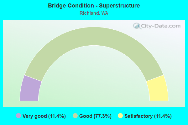
- Bridge Condition - Superstructure
- 11.4%Very good
- 77.3%Good
- 11.4%Satisfactory
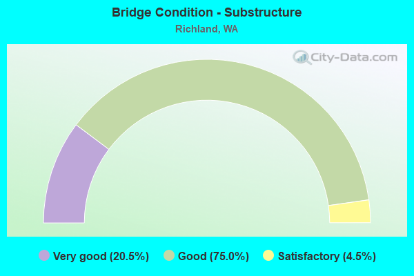
- Bridge Condition - Substructure
- 20.5%Very good
- 75.0%Good
- 4.5%Satisfactory
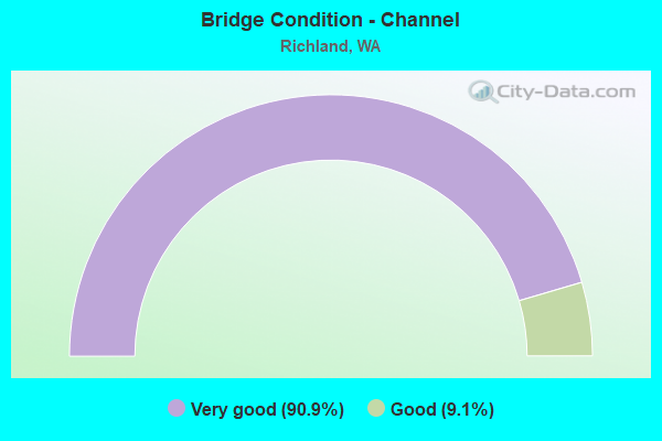
- Bridge Condition - Channel
- 90.9%Very good
- 9.1%Good
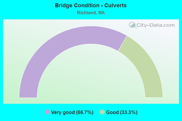
- Bridge Condition - Culverts
- 66.7%Very good
- 33.3%Good
Find on map >> Show street view
Structure Number: 81481, Location: 0.40 E RD 68N 1000 (Lat: 46.370217, Lng: -119.252186), Route carried "on" structure: ServiceCounty highway 9080, Year Built: 1967, Status: Open, Structure Length: 0.76m (2.49ft), Average Daily Traffic: 385 (year 2018), Truck Traffic: 5%, Average Future Daily Traffic: 1,100 (year 2038), Design Load: H 20, Features Intersected: PASCO PUMP LATERAL, Facility Carried by Structure: COUNTY ROAD
Minimum Vertical Clearance: 30+ m (98+ ft), Kilometerpoint: 0.001, Lanes on structure: 2, Owner: County Highway Agency, Approaching Roadway Width: 8.2m (26.9ft), Material/Design: Prestressed concrete, Design/Construction: Channel Beam, Number Of Spans In Main Unit: 1, Length of Maximum Span: 7.6m (24.9ft), Curb-To-Curb Width: 7.3m (24.0ft), Out-to-Out Width: 7.3m (24.0ft)
Condition: Deck: Very good, Superstructure: Good, Substructure: Very good, Channel: Very good, Operating Rating: 44.4 metric tons, Method Used To Determine Operating Rating: Load Factor (LF), Inventory Rating: 29.0 metric tons, Method Used To Determine Inventory Rating: Load Factor (LF), Structural Evaluation: Better than present minimum criteria, Deck Geometry: Somewhat better than minimum adequacy, Waterway Adequacy: Equal to present desirable criteria, Approach Roadway Alignment: Equal to present minimum criteria, Length Of Structure Improvement: 1.07m (3.51ft), Designated Inspection Frequency: Every 24 months, Inspection Date: December 2020, Bridge Improvement Cost: $532,000, Roadway Improvement Cost: $106,000, Total Project Cost: $1,064,000 ( Estimate for 2014), Deck Structure Type: Other, Wearing Surface/Protective System: Wearing Surface: Bituminous
Find on map >> Show street view
Structure Number: 81765, Location: AT HARRINGTON RD (Lat: 46.354733, Lng: -119.397747), Route carried "on" structure: County highway 51550, Year Built: 1967, Status: Open, Structure Length: 0.91m (2.99ft), Average Daily Traffic: 28 (year 2016), Truck Traffic: 5%, Average Future Daily Traffic: 100 (year 2038), Design Load: H 20, Features Intersected: CID CANAL, Facility Carried by Structure: YAKIMA RIVER DRIVE
Minimum Vertical Clearance: 30+ m (98+ ft), Kilometerpoint: 0.001, Lanes on structure: 2, Owner: County Highway Agency, Approaching Roadway Width: 5.2m (17.1ft), Material/Design: Prestressed concrete, Design/Construction: Channel Beam, Number Of Spans In Main Unit: 1, Length of Maximum Span: 9.1m (29.9ft), Curb-To-Curb Width: 8.4m (27.6ft), Out-to-Out Width: 8.5m (27.9ft)
Condition: Deck: Good, Superstructure: Good, Substructure: Good, Channel: Very good, Operating Rating: 34.7 metric tons, Method Used To Determine Operating Rating: Load Factor (LF) rating reported by rating factor (RF) method using MS18 loading, Inventory Rating: 20.7 metric tons, Method Used To Determine Inventory Rating: Load Factor (LF) rating reported by rating factor (RF) method using MS18 loading, Structural Evaluation: Equal to present minimum criteria, Deck Geometry: Equal to present minimum criteria, Waterway Adequacy: Equal to present desirable criteria, Approach Roadway Alignment: High priority of corrective action, Designated Inspection Frequency: Every 24 months, Inspection Date: Febuary 2020, Deck Structure Type: Other, Wearing Surface/Protective System: Wearing Surface: Bituminous
Find on map >> Show street view
Structure Number: 82375, Location: 00.63E JCT R -1105 (Lat: 46.350150, Lng: -119.240403), Route carried "on" structure: ServiceCounty highway 9120, Year Built: 1954, Year Reconstructed: 1967, Status: Open, Structure Length: 0.91m (2.99ft), Average Daily Traffic: 36 (year 2020), Truck Traffic: 44%, Average Future Daily Traffic: 164 (year 2040), Design Load: H 20, Features Intersected: PASCO PUMP LATERAL, Facility Carried by Structure: COUNTY ROAD
Minimum Vertical Clearance: 30+ m (98+ ft), Kilometerpoint: 0.001, Lanes on structure: 2, Owner: County Highway Agency, Approaching Roadway Width: 8.2m (26.9ft), Skew: 4 degrees, Material/Design: Prestressed concrete, Design/Construction: Channel Beam, Number Of Spans In Main Unit: 1, Length of Maximum Span: 9.1m (29.9ft), Curb-To-Curb Width: 8.2m (26.9ft), Out-to-Out Width: 8.2m (26.9ft)
Condition: Deck: Good, Superstructure: Good, Substructure: Good, Channel: Very good, Operating Rating: 33.4 metric tons, Method Used To Determine Operating Rating: Load and Resistance Factor Rating (LRFR) rating reported by rating factor(RF) method using HL-93 loadings, Inventory Rating: 25.9 metric tons, Method Used To Determine Inventory Rating: Load and Resistance Factor Rating (LRFR) rating reported by rating factor(RF) method using HL-93 loadings, Structural Evaluation: Equal to present minimum criteria, Deck Geometry: Equal to present minimum criteria, Waterway Adequacy: Equal to present desirable criteria, Approach Roadway Alignment: Equal to present minimum criteria, Length Of Structure Improvement: 1.22m (4.00ft), Designated Inspection Frequency: Every 24 months, Inspection Date: December 2020, Bridge Improvement Cost: $608,000, Roadway Improvement Cost: $122,000, Total Project Cost: $1,216,000 ( Estimate for 2014), Deck Structure Type: Concrete Precast Panels, Wearing Surface/Protective System: Wearing Surface: Monolithic Concrete
Find on map >> Show street view
Structure Number: 82506, Location: 0.50 mi N of WEIDLE ROAD (Lat: 46.333358, Lng: -119.348664), Route carried "on" structure: County highway 51800, Year Built: 1970, Status: Open, Structure Length: 1.04m (3.41ft), Average Daily Traffic: 1,850 (year 2018), Truck Traffic: 30%, Average Future Daily Traffic: 2,000 (year 2038), Design Load: HS 20, Features Intersected: HORN RAPIDS CORP CANAL, Facility Carried by Structure: TWIN BRIDGES ROAD
Minimum Vertical Clearance: 30+ m (98+ ft), Kilometerpoint: 0.001, Lanes on structure: 2, Owner: County Highway Agency, Approaching Roadway Width: 8.5m (27.9ft), Skew: 1 degrees, Material/Design: Prestressed concrete, Design/Construction: Stringer/Multi-beam, Number Of Spans In Main Unit: 1, Length of Maximum Span: 10.4m (34.1ft), Curb-To-Curb Width: 8.4m (27.6ft), Out-to-Out Width: 8.5m (27.9ft)
Condition: Deck: Good, Superstructure: Good, Substructure: Good, Channel: Very good, Operating Rating: 48.6 metric tons, Method Used To Determine Operating Rating: Load Factor (LF) rating reported by rating factor (RF) method using MS18 loading, Inventory Rating: 29.2 metric tons, Method Used To Determine Inventory Rating: Load Factor (LF) rating reported by rating factor (RF) method using MS18 loading, Structural Evaluation: Better than present minimum criteria, Deck Geometry: Meets minimum limits, Waterway Adequacy: Equal to present desirable criteria, Approach Roadway Alignment: Equal to present desirable criteria, Length Of Structure Improvement: 1.04m (3.41ft), Designated Inspection Frequency: Every 24 months, Inspection Date: Febuary 2020, Bridge Improvement Cost: $204,000, Roadway Improvement Cost: $41,000, Total Project Cost: $408,000 ( Estimate for 2014), Deck Structure Type: Other, Wearing Surface/Protective System: Wearing Surface: Bituminous
Find on map >> Show street view
Structure Number: 82949, Location: 00.35 NE SR-12 (Lat: 46.253028, Lng: -119.289869), Route carried "on" structure: County highway 50350, Year Built: 1967, Status: Open, Structure Length: 0.98m (3.22ft), Average Daily Traffic: 288 (year 2016), Truck Traffic: 18%, Average Future Daily Traffic: 400 (year 2038), Design Load: H 20, Features Intersected: CID CANAL, Facility Carried by Structure: VALLEY VIEW ROAD
Minimum Vertical Clearance: 30+ m (98+ ft), Kilometerpoint: 0.001, Lanes on structure: 2, Owner: County Highway Agency, Approaching Roadway Width: 6.1m (20.0ft), Skew: 1 degrees, Material/Design: Prestressed concrete, Design/Construction: Channel Beam, Number Of Spans In Main Unit: 1, Length of Maximum Span: 9.8m (32.2ft), Curb-To-Curb Width: 7.2m (23.6ft), Out-to-Out Width: 7.3m (24.0ft)
Condition: Deck: Good, Superstructure: Good, Substructure: Good, Channel: Very good, Operating Rating: 49.9 metric tons, Method Used To Determine Operating Rating: Load Factor (LF) rating reported by rating factor (RF) method using MS18 loading, Inventory Rating: 29.8 metric tons, Method Used To Determine Inventory Rating: Load Factor (LF) rating reported by rating factor (RF) method using MS18 loading, Structural Evaluation: Better than present minimum criteria, Deck Geometry: Meets minimum limits, Waterway Adequacy: Equal to present desirable criteria, Approach Roadway Alignment: Equal to present desirable criteria, Designated Inspection Frequency: Every 24 months, Inspection Date: Febuary 2020, Deck Structure Type: Other, Wearing Surface/Protective System: Wearing Surface: Bituminous
Find on map >> Show street view
Structure Number: 86072, Location: 0.69 S OF SAGEMOOR (Lat: 46.387806, Lng: -119.241750), Route carried "on" structure: County highway 9260, Year Built: 1952, Status: Posted for load, Structure Length: 0.70m (2.30ft), Average Daily Traffic: 796 (year 2019), Truck Traffic: 20%, Average Future Daily Traffic: 1,190 (year 2039), Design Load: HS 20, Features Intersected: ESQUATZEL CANAL, Facility Carried by Structure: COUNTY ROAD
Minimum Vertical Clearance: 30+ m (98+ ft), Kilometerpoint: 0.001, Lanes on structure: 2, Owner: County Highway Agency, Approaching Roadway Width: 8.5m (27.9ft), Material/Design: Concrete, Design/Construction: Slab, Number Of Spans In Main Unit: 1, Length of Maximum Span: 7.0m (23.0ft), Curb-To-Curb Width: 9.5m (31.2ft), Out-to-Out Width: 14.6m (47.9ft)
Condition: Deck: Very good, Superstructure: Good, Substructure: Very good, Channel: Very good, Operating Rating: 38.9 metric tons, Method Used To Determine Operating Rating: Load and Resistance Factor Rating (LRFR) rating reported by rating factor(RF) method using HL-93 loadings, Inventory Rating: 26.2 metric tons, Method Used To Determine Inventory Rating: Load and Resistance Factor Rating (LRFR) rating reported by rating factor(RF) method using HL-93 loadings, Structural Evaluation: Equal to present minimum criteria, Deck Geometry: Equal to present minimum criteria, Waterway Adequacy: Equal to present desirable criteria, Approach Roadway Alignment: Equal to present desirable criteria, Bridge Posting: Required (Relationship of Operating Rating to Maximum Legal Load: 0.1 - 9.9% below), Length Of Structure Improvement: 1.01m (3.31ft), Designated Inspection Frequency: Every 24 months, Inspection Date: December 2021, Bridge Improvement Cost: $502,000, Roadway Improvement Cost: $100,000, Total Project Cost: $1,003,000 ( Estimate for 2014), Deck Structure Type: Concrete Cast-file-Place, Wearing Surface/Protective System: Wearing Surface: Bituminous
Find on map >> Show street view
Structure Number: 8687, Location: 0.7 mi North of Gage Blvd (Lat: 46.236644, Lng: -119.244261), Route carried "on" structure: City street 1080, Year Built: 1999, Status: Open, Structure Length: 1.34m (4.40ft), Average Daily Traffic: 10,700 (year 2020), Truck Traffic: 5%, Average Future Daily Traffic: 24,000 (year 2040), Design Load: HS 25 or greater, Features Intersected: CID CANAL, Facility Carried by Structure: STEPTOE DRIVE
Minimum Vertical Clearance: 30+ m (98+ ft), Kilometerpoint: 9.914, Lanes on structure: 4, Base Highway Network: Yes (Inventory Route: 6, Subroute: 20), Owner: City or Municipal Highway Agency, Approaching Roadway Width: 16.8m (55.1ft), Skew: 2 degrees, Material/Design: Concrete, Design/Construction: Culvert, Number Of Spans In Main Unit: 1, Length of Maximum Span: 13.4m (44.0ft), Curb or Sidewalk Widths: Left: 1.5m (4.9ft), Right: 1.5m (4.9ft), Curb-To-Curb Width: 16.8m (55.1ft), Out-to-Out Width: 19.8m (65.0ft)
Condition: Channel: Very good, Culverts: Good, Operating Rating: 45.7 metric tons, Method Used To Determine Operating Rating: Load and Resistance Factor Rating (LRFR) rating reported by rating factor(RF) method using HL-93 loadings, Inventory Rating: 35.3 metric tons, Method Used To Determine Inventory Rating: Load and Resistance Factor Rating (LRFR) rating reported by rating factor(RF) method using HL-93 loadings, Structural Evaluation: Better than present minimum criteria, Deck Geometry: Somewhat better than minimum adequacy, Waterway Adequacy: Equal to present desirable criteria, Approach Roadway Alignment: Equal to present minimum criteria, Length Of Structure Improvement: 1.34m (4.40ft), Designated Inspection Frequency: Every 24 months, Inspection Date: December 2020, Bridge Improvement Cost: $502,000, Roadway Improvement Cost: $100,000, Total Project Cost: $1,003,000 ( Estimate for 2014)
Find on map >> Show street view
Structure Number: 88024, Location: 0.4 Mi S of Badger Road (Lat: 46.169417, Lng: -119.332789), Route carried "on" structure: County highway 55230, Year Built: 2009, Status: Open, Structure Length: 1.71m (5.61ft), Average Daily Traffic: 262 (year 2018), Truck Traffic: 2%, Average Future Daily Traffic: 500 (year 2038), Design Load: HS 20, Features Intersected: KID Canal, Facility Carried by Structure: Country Meadow Ln
Minimum Vertical Clearance: 30+ m (98+ ft), Kilometerpoint: 0.001, Lanes on structure: 2, Owner: County Highway Agency, Approaching Roadway Width: 7.3m (24.0ft), Material/Design: Concrete, Design/Construction: Stringer/Multi-beam, Number Of Spans In Main Unit: 1, Length of Maximum Span: 17.1m (56.1ft), Curb-To-Curb Width: 9.6m (31.5ft), Out-to-Out Width: 9.8m (32.2ft)
Condition: Deck: Very good, Superstructure: Very good, Substructure: Very good, Channel: Very good, Operating Rating: 50.9 metric tons, Method Used To Determine Operating Rating: Load Factor (LF) rating reported by rating factor (RF) method using MS18 loading, Inventory Rating: 30.5 metric tons, Method Used To Determine Inventory Rating: Load Factor (LF) rating reported by rating factor (RF) method using MS18 loading, Structural Evaluation: Better than present minimum criteria, Deck Geometry: Equal to present minimum criteria, Waterway Adequacy: Equal to present desirable criteria, Approach Roadway Alignment: Equal to present desirable criteria, Length Of Structure Improvement: 1.71m (5.61ft), Designated Inspection Frequency: Every 24 months, Inspection Date: Febuary 2020, Bridge Improvement Cost: $291,000, Roadway Improvement Cost: $58,000, Total Project Cost: $582,000 ( Estimate for 2014), Deck Structure Type: Concrete Precast Panels, Wearing Surface/Protective System: Wearing Surface: Monolithic Concrete
Find on map >> Show street view
Structure Number: 89066, Location: 1.33N JCT R 906(SELPH L.) (Lat: 46.345986, Lng: -119.198292), Route carried "on" structure: County highway 9030, Year Built: 2019, Status: Open, Structure Length: 2.65m (8.69ft), Average Daily Traffic: 4,444 (year 2020), Truck Traffic: 31%, Average Future Daily Traffic: 6,670 (year 2040), Design Load: HL 93, Features Intersected: ESQUATZEL CANAL, Facility Carried by Structure: COUNTY HIGHWAY
Minimum Vertical Clearance: 30+ m (98+ ft), Kilometerpoint: 0.001, Lanes on structure: 2, Owner: County Highway Agency, Approaching Roadway Width: 8.5m (27.9ft), Skew: 2 degrees, Material/Design: Prestressed concrete, Design/Construction: Tee Beam, Number Of Spans In Main Unit: 1, Length of Maximum Span: 26.5m (86.9ft), Curb-To-Curb Width: 12.2m (40.0ft), Out-to-Out Width: 13.1m (43.0ft)
Condition: Deck: Very good, Superstructure: Very good, Substructure: Very good, Channel: Very good, Operating Rating: 48.6 metric tons, Method Used To Determine Operating Rating: Load and Resistance Factor Rating (LRFR) rating reported by rating factor(RF) method using HL-93 loadings, Inventory Rating: 37.3 metric tons, Method Used To Determine Inventory Rating: Load and Resistance Factor Rating (LRFR) rating reported by rating factor(RF) method using HL-93 loadings, Structural Evaluation: Equal to present desirable criteria, Deck Geometry: Equal to present minimum criteria, Waterway Adequacy: Equal to present desirable criteria, Approach Roadway Alignment: Equal to present desirable criteria, Designated Inspection Frequency: Every 24 months, Inspection Date: December 2021, Deck Structure Type: Other, Wearing Surface/Protective System: Wearing Surface: Bituminous, Membrane: Epoxy
Find on map >> Show street view
Structure Number: 89165, Location: 0.7 N JCT I-182 (Lat: 46.263889, Lng: -119.306583), Route carried "on" structure: City street 3440, Year Built: 2020, Status: Open, Structure Length: 23.44m (76.90ft), Average Daily Traffic: 8,300 (year 2020), Truck Traffic: 3%, Average Future Daily Traffic: 20,500 (year 2040), Design Load: HL 93, Features Intersected: YAKIMA RIVER, Facility Carried by Structure: DUPORTAIL STREET
Minimum Vertical Clearance: 30+ m (98+ ft), Kilometerpoint: 0.001, Lanes on structure: 4, Owner: City or Municipal Highway Agency, Approaching Roadway Width: 18.3m (60.0ft), Material/Design: Prestressed concrete continuous, Design/Construction: Stringer/Multi-beam, Number Of Spans In Main Unit: 5, Length of Maximum Span: 54.3m (178.1ft), Curb or Sidewalk Widths: Left: 1.7m (5.6ft), Right: 1.7m (5.6ft), Curb-To-Curb Width: 18.3m (60.0ft), Out-to-Out Width: 22.6m (74.1ft)
Condition: Deck: Very good, Superstructure: Very good, Substructure: Very good, Channel: Very good, Operating Rating: 69.0 metric tons, Method Used To Determine Operating Rating: Load and Resistance Factor Rating (LRFR) rating reported by rating factor(RF) method using HL-93 loadings, Inventory Rating: 45.4 metric tons, Method Used To Determine Inventory Rating: Load and Resistance Factor Rating (LRFR) rating reported by rating factor(RF) method using HL-93 loadings, Structural Evaluation: Equal to present desirable criteria, Deck Geometry: Somewhat better than minimum adequacy, Waterway Adequacy: Equal to present desirable criteria, Approach Roadway Alignment: Equal to present desirable criteria, Length Of Structure Improvement: 23.44m (76.90ft), Designated Inspection Frequency: Every 24 months, Inspection Date: December 2020, Bridge Improvement Cost: $9,536,000, Roadway Improvement Cost: $1,907,000, Total Project Cost: $19,071,000 ( Estimate for 2014), Deck Structure Type: Concrete Cast-file-Place, Wearing Surface/Protective System: Wearing Surface: Monolithic Concrete, Deck Protection: Epoxy Coated Reinforcing
Find on map >> Show street view
Structure Number: 6279A, Location: 6.9 E JCT SR 224 (Lat: 46.232942, Lng: -119.223422), Route carried "under" structure: State highway 240, Year Built: 1960, Structure Length: 0. m, Average Daily Traffic: 57,085 (year 2019), Truck Traffic: 3%, Features Intersected: SR 240, Facility Carried by Structure: COLUMBIA CNTR BLVD
Minimum Vertical Clearance: 5.08m (16.67ft), Kilometerpoint: 62.603, Lanes on structure: 2, Lanes under structure: 6, Material/Design: Prestressed concrete, Design/Construction: Stringer/Multi-beam, Length of Maximum Span: 27.4m (89.9ft)
Find on map >> Show street view
Structure Number: 8686A, Location: 6.9 E JCT SR 224 (Lat: 46.232939, Lng: -119.223275), Route carried "under" structure: State highway 240, Year Built: 1970, Structure Length: 0. m, Average Daily Traffic: 57,085 (year 2019), Truck Traffic: 3%, Features Intersected: SR 240, Facility Carried by Structure: COLUMBIA CTR BLVD
Minimum Vertical Clearance: 5.13m (16.83ft), Kilometerpoint: 62.620, Lanes on structure: 2, Lanes under structure: 6, Material/Design: Prestressed concrete, Design/Construction: Stringer/Multi-beam, Length of Maximum Span: 26.8m (87.9ft)
Find on map >> Show street view
Structure Number: 12207A, Location: 4.0 E JCT SR 224 (Lat: 46.257175, Lng: -119.261972), Route carried "under" structure: State highway 240, Year Built: 1983, Structure Length: 0. m, Average Daily Traffic: 28,791 (year 2019), Truck Traffic: 2%, Features Intersected: SR 240/GEO WASH WAY, Facility Carried by Structure: I-182 S-E RAMP
Minimum Vertical Clearance: 5.36m (17.59ft), Kilometerpoint: 58.323, Lanes on structure: 2, Lanes under structure: 4, Material/Design: Prestressed concrete continuous, Design/Construction: Box Beam or Girders - Multiple, Length of Maximum Span: 57.3m (188.0ft)
Find on map >> Show street view
Structure Number: 12207B, Location: 3.9 E JCT I-82 (Lat: 46.258861, Lng: -119.288333), Route carried "under" structure: Interstate 182, Year Built: 1983, Structure Length: 0. m, Average Daily Traffic: 59,049 (year 2019), Truck Traffic: 7%, Features Intersected: SR 182, Facility Carried by Structure: DOE RR
Minimum Vertical Clearance: 8.53m (27.99ft), Kilometerpoint: 6.035, Lanes under structure: 4, Material/Design: Steel continuous, Design/Construction: Box Beam or Girders - Single/Spread, Length of Maximum Span: 42.7m (140.1ft)
Find on map >> Show street view
Structure Number: 12207C, Location: 0.5 E JCT SR 240 (Lat: 46.258444, Lng: -119.275083), Route carried "under" structure: Interstate 182, Year Built: 1983, Structure Length: 0. m, Average Daily Traffic: 59,049 (year 2019), Truck Traffic: 7%, Features Intersected: I-182, Facility Carried by Structure: JADWIN AVE
Minimum Vertical Clearance: 5.99m (19.65ft), Kilometerpoint: 7.017, Lanes on structure: 2, Lanes under structure: 7, Material/Design: Prestressed concrete continuous, Design/Construction: Box Beam or Girders - Multiple, Length of Maximum Span: 45.7m (149.9ft)
Find on map >> Show street view
Structure Number: 12207D, Location: 3.9 E JCT I-82 (Lat: 46.259250, Lng: -119.287111), Route carried "under" structure: Interstate 182, Year Built: 1983, Structure Length: 0. m, Average Daily Traffic: 59,049 (year 2019), Truck Traffic: 7%, Features Intersected: I-182, Facility Carried by Structure: SR 240
Minimum Vertical Clearance: 5.44m (17.85ft), Kilometerpoint: 6.164, Lanes on structure: 3, Lanes under structure: 4, Material/Design: Prestressed concrete continuous, Design/Construction: Box Beam or Girders - Multiple, Length of Maximum Span: 49.4m (162.1ft)
Find on map >> Show street view
Structure Number: 12207E, Location: 3.9 E JCT I-82 (Lat: 46.259750, Lng: -119.287389), Route carried "under" structure: Interstate 182, Year Built: 1983, Structure Length: 0. m, Average Daily Traffic: 15,509 (year 2019), Truck Traffic: 8%, Features Intersected: I-182 W-W RAMP, Facility Carried by Structure: AARON DR OLDSR240
Minimum Vertical Clearance: 5.36m (17.59ft), Kilometerpoint: 0.676, Lanes on structure: 3, Lanes under structure: 3, Material/Design: Prestressed concrete continuous, Design/Construction: Box Beam or Girders - Multiple, Length of Maximum Span: 31.7m (104.0ft)
Find on map >> Show street view
Structure Number: 12207F, Location: 1.0 E JCT SR 240 (Lat: 46.258306, Lng: -119.262500), Route carried "under" structure: Interstate 182, Year Built: 1983, Structure Length: 0. m, Average Daily Traffic: 73,878 (year 2019), Truck Traffic: 7%, Features Intersected: I-182, Facility Carried by Structure: SR 240/G WASH WAY
Minimum Vertical Clearance: 5.16m (16.93ft), Kilometerpoint: 7.966, Lanes on structure: 6, Lanes under structure: 6, Material/Design: Prestressed concrete continuous, Design/Construction: Box Beam or Girders - Multiple, Length of Maximum Span: 55.2m (181.1ft)
Find on map >> Show street view
Structure Number: 12217A, Location: 2.4 E JCT I-82 (Lat: 46.251133, Lng: -119.313453), Route carried "under" structure: Interstate 182, Year Built: 1983, Structure Length: 0. m, Average Daily Traffic: 25,281 (year 2019), Truck Traffic: 18%, Features Intersected: I-182, Facility Carried by Structure: KEENE ROAD
Minimum Vertical Clearance: 6.27m (20.57ft), Kilometerpoint: 3.862, Lanes on structure: 2, Lanes under structure: 4, Material/Design: Prestressed concrete continuous, Design/Construction: Box Beam or Girders - Multiple, Length of Maximum Span: 45.7m (149.9ft)
Find on map >> Show street view
Structure Number: 12217B, Location: 2.5 E JCT I-82 (Lat: 46.251206, Lng: -119.312836), Route carried "under" structure: Interstate 182, Year Built: 1982, Structure Length: 0. m, Average Daily Traffic: 25,281 (year 2019), Truck Traffic: 18%, Features Intersected: I-182, Facility Carried by Structure: KEENE RD
Minimum Vertical Clearance: 5.26m (17.26ft), Kilometerpoint: 3.895, Lanes on structure: 2, Lanes under structure: 4, Material/Design: Steel continuous, Design/Construction: Box Beam or Girders - Single/Spread, Length of Maximum Span: 36.3m (119.1ft)
Find on map >> Show street view
Structure Number: 12217C, Location: 2.9 E JCT I-82 (Lat: 46.254250, Lng: -119.303639), Route carried "under" structure: Interstate 182, Year Built: 1984, Structure Length: 0. m, Average Daily Traffic: 25,281 (year 2019), Truck Traffic: 18%, Features Intersected: I-182, Facility Carried by Structure: QUEENSGATE DRIVE
Minimum Vertical Clearance: 5.16m (16.93ft), Kilometerpoint: 4.715, Lanes on structure: 2, Lanes under structure: 5, Material/Design: Prestressed concrete continuous, Design/Construction: Box Beam or Girders - Multiple, Length of Maximum Span: 44.8m (147.0ft)
Find on map >> Show street view
Structure Number: 12463A, Location: 2.0 E JCT I-182 (Lat: 46.217250, Lng: -119.348056), Route carried "under" structure: County highway , Year Built: 1985, Structure Length: 0. m, Average Daily Traffic: 1,641 (year 2014), Truck Traffic: 5%, Features Intersected: DALLAS RD, Facility Carried by Structure: I-82
Minimum Vertical Clearance: 6.15m (20.18ft), Kilometerpoint: 0.113, Lanes on structure: 2, Lanes under structure: 2, Material/Design: Prestressed concrete, Design/Construction: Stringer/Multi-beam, Length of Maximum Span: 43.0m (141.1ft)
Find on map >> Show street view
Structure Number: 12463B, Location: 2.0 E JCT I-182 (Lat: 46.217472, Lng: -119.347750), Route carried "under" structure: County highway , Year Built: 1985, Structure Length: 0. m, Average Daily Traffic: 1,641 (year 2014), Truck Traffic: 5%, Features Intersected: DALLAS RD, Facility Carried by Structure: I-82
Minimum Vertical Clearance: 5.08m (16.67ft), Kilometerpoint: 0.080, Lanes on structure: 2, Lanes under structure: 2, Material/Design: Prestressed concrete, Design/Construction: Stringer/Multi-beam, Length of Maximum Span: 38.7m (127.0ft)
Find on map >> Show street view
Structure Number: 12463C, Location: 4.8 E JCT I-182 (Lat: 46.197417, Lng: -119.302306), Route carried "under" structure: Interstate 82, Year Built: 1983, Structure Length: 0. m, Average Daily Traffic: 13,686 (year 2019), Truck Traffic: 21%, Features Intersected: I-82, Facility Carried by Structure: S BERMUDA RD
Minimum Vertical Clearance: 5.61m (18.41ft), Kilometerpoint: 172.650, Lanes on structure: 2, Lanes under structure: 4, Material/Design: Prestressed concrete continuous, Design/Construction: Box Beam or Girders - Multiple, Length of Maximum Span: 37.8m (124.0ft)
Find on map >> Show street view
Structure Number: 12463D, Location: 4.3 E JCT I-182 (Lat: 46.201222, Lng: -119.328611), Route carried "under" structure: Interstate 82, Year Built: 1983, Structure Length: 0. m, Average Daily Traffic: 13,686 (year 2019), Truck Traffic: 21%, Features Intersected: I-82, Facility Carried by Structure: REATA RD
Minimum Vertical Clearance: 5.21m (17.09ft), Kilometerpoint: 170.607, Lanes on structure: 2, Lanes under structure: 4, Material/Design: Prestressed concrete continuous, Design/Construction: Box Beam or Girders - Multiple, Length of Maximum Span: 36.6m (120.1ft)
Find on map >> Show street view
Structure Number: 12558A, Location: 1.0 E JCT SR 240 (Lat: 46.259083, Lng: -119.266139), Route carried "under" structure: Interstate 182, Year Built: 1984, Structure Length: 0. m, Average Daily Traffic: 73,878 (year 2019), Truck Traffic: 7%, Features Intersected: I-182, Facility Carried by Structure: S-E RAMP
Minimum Vertical Clearance: 5.77m (18.93ft), Kilometerpoint: 7.757, Lanes on structure: 2, Lanes under structure: 7, Material/Design: Prestressed concrete continuous, Design/Construction: Box Beam or Girders - Multiple, Length of Maximum Span: 52.1m (170.9ft)
Find on map >> Show street view
Structure Number: 12558B, Location: 4.0 E JCT SR 224 (Lat: 46.257256, Lng: -119.259922), Route carried "under" structure: Ramp Interstate 240, Year Built: 1984, Structure Length: 0. m, Average Daily Traffic: 15,569 (year 2019), Truck Traffic: 7%, Features Intersected: SR 240 W-W RAMP, Facility Carried by Structure: I-182 S-E RAMP
Minimum Vertical Clearance: 5.05m (16.57ft), Kilometerpoint: 0.322, Lanes on structure: 2, Lanes under structure: 1, Material/Design: Prestressed concrete continuous, Design/Construction: Box Beam or Girders - Multiple, Length of Maximum Span: 38.4m (126.0ft)
Find on map >> Show street view
Structure Number: 12558C, Location: 1.0 E JCT SR 240 (Lat: 46.260167, Lng: -119.266361), Route carried "under" structure: Ramp Interstate 182, Year Built: 1984, Structure Length: 0. m, Average Daily Traffic: 8,925 (year 2019), Truck Traffic: 4%, Features Intersected: I-182 RAMP, Facility Carried by Structure: SR 240 RAMP
Minimum Vertical Clearance: 5.69m (18.67ft), Kilometerpoint: 0.241, Lanes on structure: 1, Lanes under structure: 2, Material/Design: Prestressed concrete, Design/Construction: Box Beam or Girders - Multiple, Length of Maximum Span: 42.7m (140.1ft)
Find on map >> Show street view
Structure Number: 12558D, Location: 1.0 E JCT SR 240 (Lat: 46.260472, Lng: -119.264389), Route carried "under" structure: City street 182, Year Built: 1984, Structure Length: 0. m, Average Daily Traffic: 31,372 (year 2019), Truck Traffic: 20%, Features Intersected: GEO. WASHINGTON WAY
Minimum Vertical Clearance: 5.69m (18.67ft), Kilometerpoint: 0.467, Lanes on structure: 1, Lanes under structure: 4, Material/Design: Prestressed concrete continuous, Design/Construction: Box Beam or Girders - Multiple, Length of Maximum Span: 51.2m (168.0ft)
Find on map >> Show street view
Structure Number: 12558E, Location: 1.0 E JCT SR 240 (Lat: 46.258472, Lng: -119.260222), Route carried "under" structure: Interstate 182, Year Built: 1984, Structure Length: 0. m, Average Daily Traffic: 73,878 (year 2019), Truck Traffic: 7%, Features Intersected: I-182, Facility Carried by Structure: SR 240 W-W RAMP
Minimum Vertical Clearance: 5.87m (19.26ft), Kilometerpoint: 8.159, Lanes on structure: 1, Lanes under structure: 6, Material/Design: Prestressed concrete continuous, Design/Construction: Box Beam or Girders - Multiple, Length of Maximum Span: 35.1m (115.2ft)