Bridge Statistics for Richmond Heights, Missouri (MO)
Condition, Traffic, Stress, Structural Evaluation, Project Costs
- National Bridge Inventory (NBI) Statistics
- 64Number of bridges
- 525ft / 160mTotal length
- $1,561,000Total costs
- 2,788,031Total average daily traffic
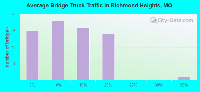
- 319,129Total average daily truck traffic
- National Bridge Inventory (NBI) Registered Bridges for Richmond Heights
- No street view available for this location
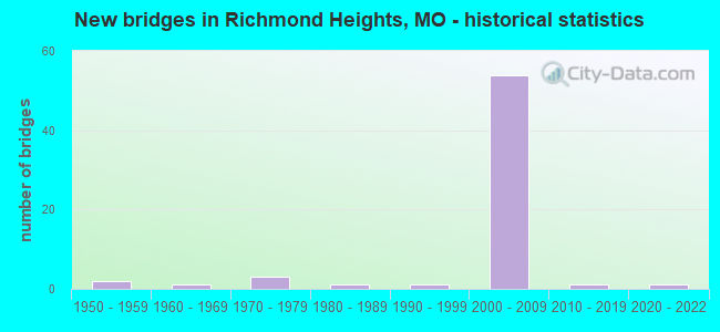
- New bridges - historical statistics
- 21950-1959
- 11960-1969
- 31970-1979
- 11980-1989
- 11990-1999
- 542000-2009
- 12010-2019
- 12020-2022

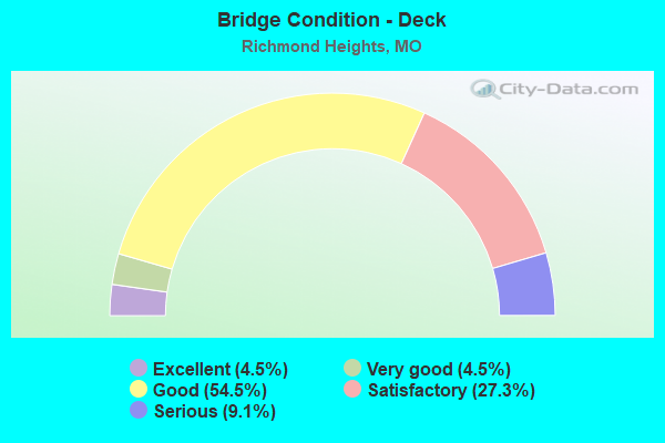
- Bridge Condition - Deck
- 4.5%Excellent
- 4.5%Very good
- 54.5%Good
- 27.3%Satisfactory
- 9.1%Serious
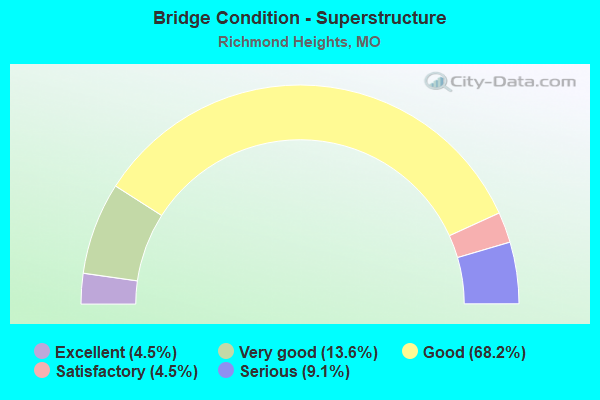
- Bridge Condition - Superstructure
- 4.5%Excellent
- 13.6%Very good
- 68.2%Good
- 4.5%Satisfactory
- 9.1%Serious
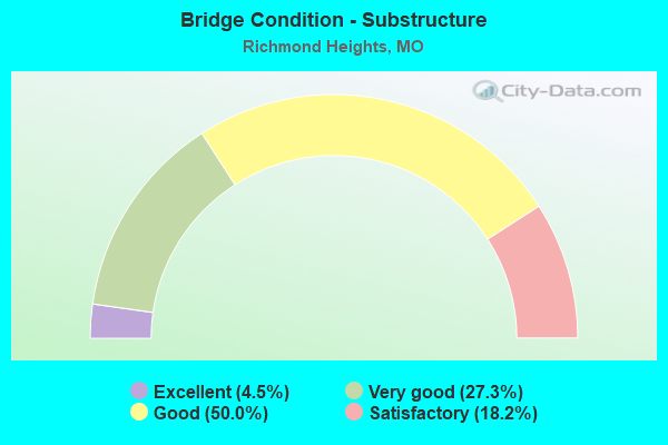
- Bridge Condition - Substructure
- 4.5%Excellent
- 27.3%Very good
- 50.0%Good
- 18.2%Satisfactory
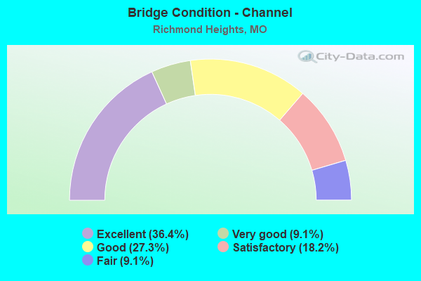
- Bridge Condition - Channel
- 36.4%Excellent
- 9.1%Very good
- 27.3%Good
- 18.2%Satisfactory
- 9.1%Fair
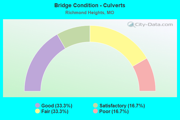
- Bridge Condition - Culverts
- 33.3%Good
- 16.7%Satisfactory
- 33.3%Fair
- 16.7%Poor
Find on map >> Show street view
Structure Number: 32264, Location: S 21 T 45 N R 6 E (Lat: 38.630117, Lng: -90.343822), Route carried "under" structure: Interstate 170, Year Built: 2008, Structure Length: 0. m, Average Daily Traffic: 36,023 (year 2021), Truck Traffic: 4%, Features Intersected: IS 170, Facility Carried by Structure: RP HANLEY DR TO IS
Minimum Vertical Clearance: 4.83m (15.85ft), Kilometerpoint: 17.801, Lanes on structure: 2, Lanes under structure: 2, Material/Design: Prestressed concrete, Design/Construction: Tee Beam, Length of Maximum Span: 28.7m (94.2ft)
Find on map >> Show street view
Structure Number: 32264, Location: S 21 T 45 N R 6 E (Lat: 38.630117, Lng: -90.343822), Route carried "under" structure: Interstate 170, Year Built: 2008, Structure Length: 0. m, Average Daily Traffic: 41,344 (year 2021), Truck Traffic: 6%, Features Intersected: IS 170, Facility Carried by Structure: RP HANLEY DR TO IS
Minimum Vertical Clearance: 4.80m (15.75ft), Kilometerpoint: 0.116, Lanes on structure: 2, Lanes under structure: 3, Material/Design: Prestressed concrete, Design/Construction: Tee Beam, Length of Maximum Span: 28.7m (94.2ft)
Find on map >> Show street view
Structure Number: 32265, Location: S 21 T 45 N R 6 E (Lat: 38.629708, Lng: -90.343731), Route carried "under" structure: Interstate 170, Year Built: 2008, Structure Length: 0. m, Average Daily Traffic: 41,344 (year 2021), Truck Traffic: 6%, Features Intersected: IS 170, Facility Carried by Structure: IS 64 E
Minimum Vertical Clearance: 5.13m (16.83ft), Kilometerpoint: 0.069, Lanes on structure: 6, Lanes under structure: 3, Material/Design: Prestressed concrete, Design/Construction: Tee Beam, Length of Maximum Span: 28.2m (92.5ft)
Find on map >> Show street view
Structure Number: 32265, Location: S 21 T 45 N R 6 E (Lat: 38.629708, Lng: -90.343731), Route carried "under" structure: Interstate 170, Year Built: 2008, Structure Length: 0. m, Average Daily Traffic: 36,023 (year 2021), Truck Traffic: 4%, Features Intersected: IS 170, Facility Carried by Structure: IS 64 E
Minimum Vertical Clearance: 5.13m (16.83ft), Kilometerpoint: 17.848, Lanes on structure: 6, Lanes under structure: 2, Material/Design: Prestressed concrete, Design/Construction: Tee Beam, Length of Maximum Span: 28.2m (92.5ft)
Find on map >> Show street view
Structure Number: 32267, Location: S 22 T 45 N R 6 E (Lat: 38.629322, Lng: -90.323331), Route carried "under" structure: City street , Year Built: 2008, Structure Length: 0. m, Average Daily Traffic: 948 (year 2021), Truck Traffic: 5%, Features Intersected: CST CLAYTONIA TER, Facility Carried by Structure: IS 64 E
Minimum Vertical Clearance: 4.72m (15.49ft), Kilometerpoint: 0.698, Lanes on structure: 8, Lanes under structure: 2, Material/Design: Prestressed concrete, Design/Construction: Stringer/Multi-beam, Length of Maximum Span: 15.4m (50.5ft)
Find on map >> Show street view
Structure Number: 3227, Location: S 21 T 45 N R 6 E (Lat: 38.629867, Lng: -90.346208), Route carried "under" structure: City street , Year Built: 2008, Structure Length: 0. m, Average Daily Traffic: 37,774 (year 2021), Truck Traffic: 5%, Features Intersected: CST S BRENTWOOD BLVD, Facility Carried by Structure: IS 64 E
Minimum Vertical Clearance: 5.26m (17.26ft), Kilometerpoint: 2.372, Lanes on structure: 6, Lanes under structure: 10, Material/Design: Prestressed concrete, Design/Construction: Stringer/Multi-beam, Length of Maximum Span: 44.7m (146.7ft)