Bridge Statistics for Richmond, Indiana (IN)
Condition, Traffic, Stress, Structural Evaluation, Project Costs
- National Bridge Inventory (NBI) Statistics
- 171Number of bridges
- 1,699ft / 518mTotal length
- $12,010,000Total costs
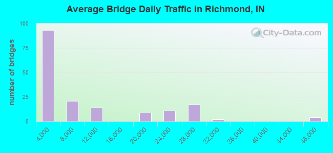
- 1,492,982Total average daily traffic
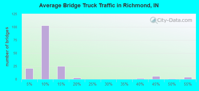
- 204,007Total average daily truck traffic
- National Bridge Inventory (NBI) Registered Bridges for Richmond
- No street view available for this location
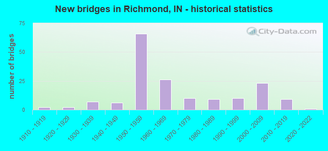
- New bridges - historical statistics
- 21910-1919
- 21920-1929
- 71930-1939
- 61940-1949
- 661950-1959
- 261960-1969
- 101970-1979
- 91980-1989
- 101990-1999
- 232000-2009
- 92010-2019
- 12020-2022
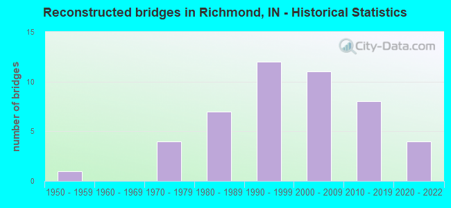
- Reconstructed bridges - Historical Statistics
- 11950-1959
- 01960-1969
- 41970-1979
- 71980-1989
- 121990-1999
- 112000-2009
- 82010-2019
- 42020-2022
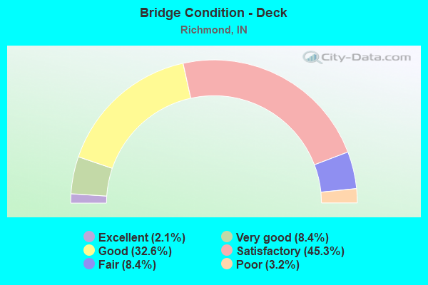
- Bridge Condition - Deck
- 2.1%Excellent
- 8.4%Very good
- 32.6%Good
- 45.3%Satisfactory
- 8.4%Fair
- 3.2%Poor
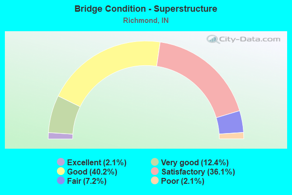
- Bridge Condition - Superstructure
- 2.1%Excellent
- 12.4%Very good
- 40.2%Good
- 36.1%Satisfactory
- 7.2%Fair
- 2.1%Poor
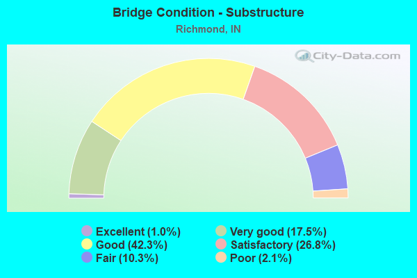
- Bridge Condition - Substructure
- 1.0%Excellent
- 17.5%Very good
- 42.3%Good
- 26.8%Satisfactory
- 10.3%Fair
- 2.1%Poor
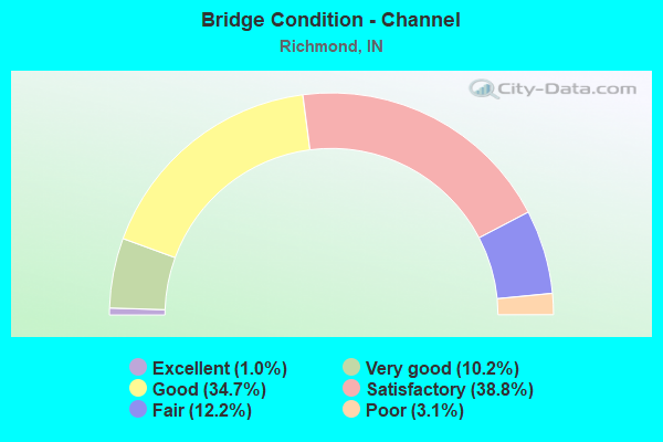
- Bridge Condition - Channel
- 1.0%Excellent
- 10.2%Very good
- 34.7%Good
- 38.8%Satisfactory
- 12.2%Fair
- 3.1%Poor
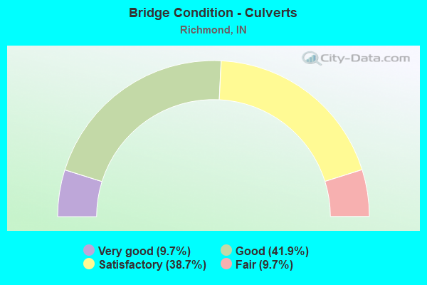
- Bridge Condition - Culverts
- 9.7%Very good
- 41.9%Good
- 38.7%Satisfactory
- 9.7%Fair
Find on map >> Show street view
Structure Number: 8900242, Location: 00.10 W of UNION Pk (Lat: 39.862861, Lng: -84.931050), Route carried "on" structure: City street , Year Built: 1999, Status: Open, Structure Length: 0.78m (2.56ft), Average Daily Traffic: 3,921 (year 2016), Truck Traffic: 5%, Average Future Daily Traffic: 5,286 (year 2036), Features Intersected: CLEAR Creek, Facility Carried by Structure: INDUSTRIES Rd
Minimum Vertical Clearance: 30+ m (98+ ft), Kilometerpoint: 0.000, Lanes on structure: 2, Owner: County Highway Agency, Approaching Roadway Width: 7.3m (24.0ft), Material/Design: Concrete, Design/Construction: Culvert, Number Of Spans In Main Unit: 1, Length of Maximum Span: 7.3m (24.0ft), Curb-To-Curb Width: 17.7m (58.1ft), Out-to-Out Width: 17.7m (58.1ft)
Condition: Channel: Satisfactory, Culverts: Good, Operating Rating: 54.5 metric tons, Method Used To Determine Operating Rating: Field evaluation and documented engineering judgment, Inventory Rating: 32.7 metric tons, Method Used To Determine Inventory Rating: Field evaluation and documented engineering judgment, Structural Evaluation: Better than present minimum criteria, Deck Geometry: Superior to present desirable criteria, Waterway Adequacy: Better than present minimum criteria, Approach Roadway Alignment: Equal to present desirable criteria, Designated Inspection Frequency: Every 24 months, Inspection Date: April 2020
Find on map >> Show street view
Structure Number: 8900243, Location: 00.20 E of ROUND BARN Rd (Lat: 39.857069, Lng: -84.955931), Route carried "on" structure: County highway , Year Built: 2000, Status: Open, Structure Length: 0.78m (2.56ft), Average Daily Traffic: 2,297 (year 2016), Truck Traffic: 5%, Average Future Daily Traffic: 3,097 (year 2036), Features Intersected: LICK Creek, Facility Carried by Structure: INDUSTRIES Rd
Minimum Vertical Clearance: 30+ m (98+ ft), Kilometerpoint: 0.000, Lanes on structure: 2, Owner: County Highway Agency, Approaching Roadway Width: 7.3m (24.0ft), Skew: 1 degrees, Material/Design: Concrete, Design/Construction: Culvert, Number Of Spans In Main Unit: 1, Length of Maximum Span: 7.3m (24.0ft), Curb-To-Curb Width: 17.6m (57.7ft), Out-to-Out Width: 17.6m (57.7ft)
Condition: Channel: Satisfactory, Culverts: Good, Operating Rating: 54.5 metric tons, Method Used To Determine Operating Rating: Field evaluation and documented engineering judgment, Inventory Rating: 32.7 metric tons, Method Used To Determine Inventory Rating: Field evaluation and documented engineering judgment, Structural Evaluation: Better than present minimum criteria, Deck Geometry: Superior to present desirable criteria, Waterway Adequacy: Equal to present desirable criteria, Approach Roadway Alignment: Equal to present desirable criteria, Designated Inspection Frequency: Every 24 months, Inspection Date: May 2020
Find on map >> Show street view
Structure Number: 8900244, Location: 00.30 W of UNION Pk (Lat: 39.858911, Lng: -84.953681), Route carried "on" structure: County highway , Year Built: 1999, Status: Open, Structure Length: 0.71m (2.33ft), Average Daily Traffic: 2,286 (year 2016), Truck Traffic: 5%, Average Future Daily Traffic: 3,082 (year 2036), Features Intersected: Unnamed Ditch, Facility Carried by Structure: INDUSTRIES Rd
Minimum Vertical Clearance: 30+ m (98+ ft), Kilometerpoint: 0.000, Lanes on structure: 2, Owner: County Highway Agency, Approaching Roadway Width: 7.3m (24.0ft), Skew: 2 degrees, Material/Design: Concrete, Design/Construction: Culvert, Number Of Spans In Main Unit: 1, Length of Maximum Span: 6.7m (22.0ft), Curb-To-Curb Width: 17.3m (56.8ft), Out-to-Out Width: 17.3m (56.8ft)
Condition: Channel: Good, Culverts: Good, Operating Rating: 54.5 metric tons, Method Used To Determine Operating Rating: Field evaluation and documented engineering judgment, Inventory Rating: 32.7 metric tons, Method Used To Determine Inventory Rating: Field evaluation and documented engineering judgment, Structural Evaluation: Better than present minimum criteria, Deck Geometry: Superior to present desirable criteria, Waterway Adequacy: Better than present minimum criteria, Approach Roadway Alignment: Equal to present desirable criteria, Designated Inspection Frequency: Every 24 months, Inspection Date: May 2020
Find on map >> Show street view
Structure Number: 8900247, Location: 00.10 E of FIRST St (Lat: 39.829100, Lng: -84.902050), Route carried "on" structure: City street , Year Built: 2004, Status: Open, Structure Length: 10.20m (33.46ft), Average Daily Traffic: 10,526 (year 2016), Truck Traffic: 3%, Average Future Daily Traffic: 14,190 (year 2036), Design Load: HS 20, Features Intersected: E FK WWR, SIM HODGIN,PED, Facility Carried by Structure: MAIN STREET
Minimum Vertical Clearance: 30+ m (98+ ft), Kilometerpoint: 0.000, Lanes on structure: 2, Lanes under structure: 2, Owner: County Highway Agency, Approaching Roadway Width: 8.5m (27.9ft), Material/Design: Prestressed concrete continuous, Design/Construction: Stringer/Multi-beam, Number Of Spans In Main Unit: 3, Length of Maximum Span: 41.1m (134.8ft), Curb or Sidewalk Widths: Left: 1.8m (5.9ft), Right: 3.0m (9.8ft), Curb-To-Curb Width: 8.5m (27.9ft), Out-to-Out Width: 14.6m (47.9ft)
Condition: Deck: Good, Superstructure: Good, Substructure: Good, Channel: Good, Operating Rating: 54.5 metric tons, Method Used To Determine Operating Rating: Field evaluation and documented engineering judgment, Inventory Rating: 32.7 metric tons, Method Used To Determine Inventory Rating: Field evaluation and documented engineering judgment, Structural Evaluation: Better than present minimum criteria, Deck Geometry: Meets minimum limits, Underclear: Meets minimum limits, Waterway Adequacy: Equal to present desirable criteria, Approach Roadway Alignment: Equal to present desirable criteria, Designated Inspection Frequency: Every 24 months, Inspection Date: April 2020, Deck Structure Type: Concrete Cast-file-Place, Wearing Surface/Protective System: Wearing Surface: Monolithic Concrete, Deck Protection: Epoxy Coated Reinforcing
Find on map >> Show street view
Structure Number: 8900253, Location: 00.70 N of SR 27 (Lat: 39.790861, Lng: -84.908931), Route carried "on" structure: City street , Year Built: 2009, Status: Open, Structure Length: 0.85m (2.79ft), Average Daily Traffic: 588 (year 2016), Truck Traffic: 5%, Average Future Daily Traffic: 793 (year 2036), Features Intersected: UNNAMED CREEK, Facility Carried by Structure: LIBERTY AVE
Minimum Vertical Clearance: 30+ m (98+ ft), Kilometerpoint: 0.000, Lanes on structure: 2, Owner: County Highway Agency, Approaching Roadway Width: 8.5m (27.9ft), Skew: 4 degrees, Material/Design: Concrete, Design/Construction: Culvert, Number Of Spans In Main Unit: 1, Length of Maximum Span: 7.8m (25.6ft), Curb-To-Curb Width: 8.5m (27.9ft), Out-to-Out Width: 8.5m (27.9ft)
Condition: Channel: Satisfactory, Culverts: Good, Operating Rating: 54.2 metric tons, Method Used To Determine Operating Rating: Field evaluation and documented engineering judgment, Inventory Rating: 32.7 metric tons, Method Used To Determine Inventory Rating: Field evaluation and documented engineering judgment, Structural Evaluation: Better than present minimum criteria, Deck Geometry: Somewhat better than minimum adequacy, Waterway Adequacy: Better than present minimum criteria, Approach Roadway Alignment: Equal to present desirable criteria, Designated Inspection Frequency: Every 24 months, Inspection Date: April 2020
Find on map >> Show street view
Structure Number: 8900255, Location: 00.30 S of L St (Lat: 39.840161, Lng: -84.907939), Route carried "on" structure: City street , Year Built: 2011, Status: Open, Structure Length: 2.24m (7.35ft), Average Daily Traffic: 7,666 (year 2016), Truck Traffic: 10%, Average Future Daily Traffic: 10,334 (year 2036), Design Load: HS 25 or greater, Features Intersected: N&S RR, Facility Carried by Structure: NW 5TH ST
Minimum Vertical Clearance: 30+ m (98+ ft), Kilometerpoint: 0.000, Lanes on structure: 2, Owner: County Highway Agency, Approaching Roadway Width: 7.9m (25.9ft), Skew: 2 degrees, Material/Design: Steel, Design/Construction: Stringer/Multi-beam, Number Of Spans In Main Unit: 1, Length of Maximum Span: 21.9m (71.9ft), Curb or Sidewalk Widths: Left: 2.0m (6.6ft), Right: 2.0m (6.6ft), Curb-To-Curb Width: 10.4m (34.1ft), Out-to-Out Width: 15.1m (49.5ft)
Condition: Deck: Very good, Superstructure: Very good, Substructure: Very good, Operating Rating: 82.6 metric tons, Method Used To Determine Operating Rating: Load Factor (LF), Inventory Rating: 49.6 metric tons, Method Used To Determine Inventory Rating: Load Factor (LF), Structural Evaluation: Equal to present desirable criteria, Deck Geometry: Meets minimum limits, Underclear: Better than present minimum criteria, Approach Roadway Alignment: Equal to present minimum criteria, Designated Inspection Frequency: Every 24 months, Inspection Date: April 2020, Deck Structure Type: Concrete Cast-file-Place, Wearing Surface/Protective System: Wearing Surface: Monolithic Concrete, Deck Protection: Epoxy Coated Reinforcing
Find on map >> Show street view
Structure Number: 8900256, Location: .1 MI. W OF ROUND BARN RD (Lat: 39.852811, Lng: -84.956939), Route carried "on" structure: City street , Year Built: 2012, Status: Open, Structure Length: 0.67m (2.20ft), Average Daily Traffic: 543 (year 2016), Truck Traffic: 5%, Average Future Daily Traffic: 732 (year 2036), Design Load: HS 20, Features Intersected: LICK CREEK, Facility Carried by Structure: GAAR JACKSON ROAD
Minimum Vertical Clearance: 30+ m (98+ ft), Kilometerpoint: 0.000, Lanes on structure: 2, Owner: County Highway Agency, Approaching Roadway Width: 5.8m (19.0ft), Material/Design: Concrete, Design/Construction: Culvert, Number Of Spans In Main Unit: 1, Length of Maximum Span: 6.1m (20.0ft), Curb-To-Curb Width: 10.9m (35.8ft), Out-to-Out Width: 11.0m (36.1ft)
Condition: Channel: Very good, Culverts: Very good, Operating Rating: 78.7 metric tons, Method Used To Determine Operating Rating: Load Factor (LF), Inventory Rating: 47.0 metric tons, Method Used To Determine Inventory Rating: Load Factor (LF), Structural Evaluation: Equal to present desirable criteria, Deck Geometry: Equal to present minimum criteria, Waterway Adequacy: Equal to present desirable criteria, Approach Roadway Alignment: Equal to present desirable criteria, Designated Inspection Frequency: Every 24 months, Inspection Date: May 2020, Deck Structure Type: Concrete Cast-file-Place, Wearing Surface/Protective System: Wearing Surface: Monolithic Concrete
Find on map >> Show street view
Structure Number: 8900257, Location: 00.1 E OF NW 13TH ST (Lat: 39.838339, Lng: -84.918481), Route carried "on" structure: Alternate City street , Year Built: 1985, Status: Open, Structure Length: 1.46m (4.79ft), Average Daily Traffic: 595 (year 2016), Truck Traffic: 5%, Average Future Daily Traffic: 803 (year 2036), Features Intersected: CLEAR CREEK, Facility Carried by Structure: INDIANA AVE
Minimum Vertical Clearance: 30+ m (98+ ft), Kilometerpoint: 0.000, Lanes on structure: 2, Owner: County Highway Agency, Approaching Roadway Width: 6.1m (20.0ft), Material/Design: Prestressed concrete, Design/Construction: Box Beam or Girders - Multiple, Number Of Spans In Main Unit: 1, Length of Maximum Span: 13.0m (42.7ft), Curb-To-Curb Width: 7.9m (25.9ft), Out-to-Out Width: 7.9m (25.9ft)
Condition: Deck: Good, Superstructure: Good, Substructure: Very good, Channel: Good, Operating Rating: 54.5 metric tons, Method Used To Determine Operating Rating: Field evaluation and documented engineering judgment, Inventory Rating: 32.7 metric tons, Method Used To Determine Inventory Rating: Field evaluation and documented engineering judgment, Structural Evaluation: Better than present minimum criteria, Deck Geometry: Somewhat better than minimum adequacy, Waterway Adequacy: Equal to present desirable criteria, Approach Roadway Alignment: Equal to present desirable criteria, Designated Inspection Frequency: Every 24 months, Inspection Date: April 2020, Deck Structure Type: Concrete Cast-file-Place, Wearing Surface/Protective System: Wearing Surface: Integral Concrete
Find on map >> Show street view
Structure Number: 8900267, Location: 0.1 MILES EAST OF 13th ST (Lat: 39.832819, Lng: -84.918939), Route carried "on" structure: City street , Year Built: 2018, Status: Open, Structure Length: 1.04m (3.41ft), Average Daily Traffic: 3,328 (year 2018), Truck Traffic: 5%, Average Future Daily Traffic: 4,486 (year 2038), Design Load: HL 93, Features Intersected: CLEAR CREEK, Facility Carried by Structure: PEACOCK RD
Minimum Vertical Clearance: 30+ m (98+ ft), Kilometerpoint: 0.000, Lanes on structure: 2, Owner: County Highway Agency, Approaching Roadway Width: 9.8m (32.2ft), Material/Design: Concrete, Design/Construction: Culvert, Number Of Spans In Main Unit: 1, Length of Maximum Span: 9.8m (32.2ft), Curb or Sidewalk Widths: Left: 0.0m, Right: 1.4m (4.6ft), Curb-To-Curb Width: 9.8m (32.2ft), Out-to-Out Width: 11.1m (36.4ft)
Condition: Channel: Very good, Culverts: Very good, Operating Rating: 46.0 metric tons, Method Used To Determine Operating Rating: Field evaluation and documented engineering judgment, Inventory Rating: 27.8 metric tons, Method Used To Determine Inventory Rating: Field evaluation and documented engineering judgment, Structural Evaluation: Equal to present minimum criteria, Deck Geometry: Meets minimum limits, Waterway Adequacy: Equal to present desirable criteria, Approach Roadway Alignment: Equal to present desirable criteria, Designated Inspection Frequency: Every 24 months, Inspection Date: May 2020
Find on map >> Show street view
Structure Number: 890027, Location: 00.10 S of VI POST ROAD (Lat: 39.798589, Lng: -84.946439), Route carried "on" structure: Alternate County highway , Year Built: 2020, Status: Open, Structure Length: 1.45m (4.76ft), Average Daily Traffic: 967 (year 2020), Truck Traffic: 5%, Average Future Daily Traffic: 1,304 (year 2040), Design Load: HL 93, Features Intersected: UNNAMED TRIB/LICK CREEK, Facility Carried by Structure: SALISBURY ROAD
Minimum Vertical Clearance: 30+ m (98+ ft), Kilometerpoint: 0.000, Lanes on structure: 2, Owner: County Highway Agency, Approaching Roadway Width: 6.1m (20.0ft), Skew: 1 degrees, Material/Design: Prestressed concrete, Design/Construction: Stringer/Multi-beam, Number Of Spans In Main Unit: 1, Length of Maximum Span: 13.6m (44.6ft), Curb-To-Curb Width: 7.3m (24.0ft), Out-to-Out Width: 7.5m (24.6ft)
Condition: Deck: Excellent, Superstructure: Very good, Substructure: Excellent, Channel: Very good, Operating Rating: 79.9 metric tons, Method Used To Determine Operating Rating: Load and Resistance Factor (LRFR), Inventory Rating: 58.8 metric tons, Method Used To Determine Inventory Rating: Load and Resistance Factor (LRFR), Structural Evaluation: Equal to present desirable criteria, Deck Geometry: Meets minimum limits, Waterway Adequacy: Better than present minimum criteria, Approach Roadway Alignment: Equal to present desirable criteria, Designated Inspection Frequency: Every 24 months, Inspection Date: July 2020, Deck Structure Type: Concrete Cast-file-Place, Wearing Surface/Protective System: Wearing Surface: Monolithic Concrete, Membrane: Other, Deck Protection: Epoxy Coated Reinforcing
Find on map >> Show street view
Structure Number: 719, Location: 00.52 N SR-227 (Lat: 39.810131, Lng: -84.890669), Route carried "under" structure: City street , Year Built: 1960, Structure Length: 0. m, Average Daily Traffic: 118 (year 2004), Truck Traffic: 1%, Features Intersected: SOUTH 'O' STREET, Facility Carried by Structure: US 27
Minimum Vertical Clearance: 4.65m (15.26ft), Kilometerpoint: 0.000, Lanes on structure: 4, Lanes under structure: 2, Material/Design: Prestressed concrete continuous, Design/Construction: Stringer/Multi-beam, Length of Maximum Span: 19.5m (64.0ft)
Find on map >> Show street view
Structure Number: 72, Location: 00.30 N US 40 WB (Lat: 39.834950, Lng: -84.890231), Route carried "under" structure: City street , Year Built: 1952, Structure Length: 0. m, Average Daily Traffic: 1,592 (year 2013), Truck Traffic: 1%, Features Intersected: NORTH 'F' STREET, Facility Carried by Structure: US 27
Minimum Vertical Clearance: 5.54m (18.18ft), Kilometerpoint: 0.000, Lanes on structure: 4, Lanes under structure: 2, Material/Design: Steel continuous, Design/Construction: Stringer/Multi-beam, Length of Maximum Span: 28.4m (93.2ft)
Find on map >> Show street view
Structure Number: 72, Location: 00.30 N US 40 WB (Lat: 39.834950, Lng: -84.890231), Route carried "under" structure: City street , Year Built: 1952, Structure Length: 0. m, Average Daily Traffic: 1,000 (year 2011), Truck Traffic: 2%, Features Intersected: NORTH 10TH ST EB, Facility Carried by Structure: US 27
Minimum Vertical Clearance: 6.45m (21.16ft), Kilometerpoint: 0.000, Lanes on structure: 4, Lanes under structure: 2, Material/Design: Steel continuous, Design/Construction: Stringer/Multi-beam, Length of Maximum Span: 28.4m (93.2ft)
Find on map >> Show street view
Structure Number: 72, Location: 00.30 N US 40 WB (Lat: 39.834950, Lng: -84.890231), Route carried "under" structure: City street , Year Built: 1952, Structure Length: 0. m, Average Daily Traffic: 1,000 (year 2011), Truck Traffic: 2%, Features Intersected: NORTH 10TH ST WB, Facility Carried by Structure: US 27
Minimum Vertical Clearance: 5.92m (19.42ft), Kilometerpoint: 0.000, Lanes on structure: 4, Lanes under structure: 2, Material/Design: Steel continuous, Design/Construction: Stringer/Multi-beam, Length of Maximum Span: 28.4m (93.2ft)
Find on map >> Show street view
Structure Number: 72, Location: 00.30 N US 40 WB (Lat: 39.834950, Lng: -84.890231), Route carried "under" structure: City street , Year Built: 1952, Structure Length: 0. m, Average Daily Traffic: 300 (year 2011), Truck Traffic: 1%, Features Intersected: NORTH 'D' STREET, Facility Carried by Structure: US 27
Minimum Vertical Clearance: 6.55m (21.49ft), Kilometerpoint: 0.000, Lanes on structure: 4, Lanes under structure: 2, Material/Design: Steel continuous, Design/Construction: Stringer/Multi-beam, Length of Maximum Span: 28.4m (93.2ft)
Find on map >> Show street view
Structure Number: 72, Location: 00.30 N US 40 WB (Lat: 39.834950, Lng: -84.890231), Route carried "under" structure: City street , Year Built: 1952, Structure Length: 0. m, Average Daily Traffic: 118 (year 2004), Truck Traffic: 1%, Features Intersected: ELM PLACE, Facility Carried by Structure: US 27
Minimum Vertical Clearance: 4.80m (15.75ft), Kilometerpoint: 0.000, Lanes on structure: 4, Lanes under structure: 2, Material/Design: Steel continuous, Design/Construction: Stringer/Multi-beam, Length of Maximum Span: 28.4m (93.2ft)
Find on map >> Show street view
Structure Number: 72, Location: 00.30 N US 40 WB (Lat: 39.834950, Lng: -84.890231), Route carried "under" structure: ServiceCity street , Year Built: 1952, Structure Length: 0. m, Average Daily Traffic: 50 (year 2011), Truck Traffic: 1%, Features Intersected: NORTH 'E' STREET, Facility Carried by Structure: US 27
Minimum Vertical Clearance: 4.14m (13.58ft), Kilometerpoint: 0.000, Lanes on structure: 4, Lanes under structure: 2, Material/Design: Steel continuous, Design/Construction: Stringer/Multi-beam, Length of Maximum Span: 28.4m (93.2ft)
Find on map >> Show street view
Structure Number: 72, Location: 00.30 N US 40 WB (Lat: 39.834950, Lng: -84.890231), Route carried "under" structure: ServiceCity street , Year Built: 1952, Structure Length: 0. m, Average Daily Traffic: 6,036 (year 2013), Truck Traffic: 1%, Features Intersected: NORTH 'E' ST SB, Facility Carried by Structure: US 27
Minimum Vertical Clearance: 4.17m (13.68ft), Kilometerpoint: 0.000, Lanes on structure: 4, Lanes under structure: 2, Material/Design: Steel continuous, Design/Construction: Stringer/Multi-beam, Length of Maximum Span: 28.4m (93.2ft)
Find on map >> Show street view
Structure Number: 7221, Location: 02.22 N SR-121 (Lat: 39.872181, Lng: -84.888439), Route carried "under" structure: Interstate 70, Year Built: 2008, Structure Length: 0. m, Average Daily Traffic: 24,062 (year 2004), Truck Traffic: 38%, Features Intersected: I-70 EBL, Facility Carried by Structure: US 27
Minimum Vertical Clearance: 6.53m (21.42ft), Kilometerpoint: 242.480, Lanes on structure: 6, Lanes under structure: 4, Material/Design: Steel continuous, Design/Construction: Stringer/Multi-beam, Length of Maximum Span: 27.5m (90.2ft)
Find on map >> Show street view
Structure Number: 7221, Location: 02.22 N SR-121 (Lat: 39.872181, Lng: -84.888439), Route carried "under" structure: Interstate 70, Year Built: 2008, Structure Length: 0. m, Average Daily Traffic: 24,062 (year 2004), Truck Traffic: 38%, Features Intersected: I-70 WBL, Facility Carried by Structure: US 27
Minimum Vertical Clearance: 6.12m (20.08ft), Kilometerpoint: 242.480, Lanes on structure: 6, Lanes under structure: 4, Material/Design: Steel continuous, Design/Construction: Stringer/Multi-beam, Length of Maximum Span: 27.5m (90.2ft)
Find on map >> Show street view
Structure Number: 1105, Location: 01.26 S SR 38 (Lat: 39.867669, Lng: -84.924431), Route carried "under" structure: Interstate 70, Year Built: 1959, Structure Length: 0. m, Average Daily Traffic: 24,201 (year 2004), Truck Traffic: 12%, Features Intersected: I-70 WB, Facility Carried by Structure: US 35 NB
Minimum Vertical Clearance: 5.46m (17.91ft), Kilometerpoint: 239.374, Lanes on structure: 3, Lanes under structure: 5, Material/Design: Steel continuous, Design/Construction: Stringer/Multi-beam, Length of Maximum Span: 23.3m (76.4ft)
Find on map >> Show street view
Structure Number: 1105, Location: 01.26 S SR 38 (Lat: 39.867669, Lng: -84.924431), Route carried "under" structure: Interstate 70, Year Built: 1959, Structure Length: 0. m, Average Daily Traffic: 24,200 (year 2004), Truck Traffic: 12%, Features Intersected: I-70 EB, Facility Carried by Structure: US 35 NB
Minimum Vertical Clearance: 5.11m (16.77ft), Kilometerpoint: 239.374, Lanes on structure: 3, Lanes under structure: 5, Material/Design: Steel continuous, Design/Construction: Stringer/Multi-beam, Length of Maximum Span: 23.3m (76.4ft)
Find on map >> Show street view
Structure Number: 1106, Location: 01.26 S SR 38 (Lat: 39.867419, Lng: -84.926281), Route carried "under" structure: Interstate 70, Year Built: 1959, Structure Length: 0. m, Average Daily Traffic: 24,200 (year 2004), Truck Traffic: 12%, Features Intersected: I-70 EB, Facility Carried by Structure: US 35 SB
Minimum Vertical Clearance: 5.13m (16.83ft), Kilometerpoint: 239.213, Lanes on structure: 3, Lanes under structure: 5, Material/Design: Steel continuous, Design/Construction: Stringer/Multi-beam, Length of Maximum Span: 27.5m (90.2ft)
Find on map >> Show street view
Structure Number: 1106, Location: 01.26 S SR 38 (Lat: 39.867419, Lng: -84.926281), Route carried "under" structure: Interstate 70, Year Built: 1959, Structure Length: 0. m, Average Daily Traffic: 24,201 (year 2004), Truck Traffic: 12%, Features Intersected: I-70 WB, Facility Carried by Structure: US 35 SB
Minimum Vertical Clearance: 5.08m (16.67ft), Kilometerpoint: 239.213, Lanes on structure: 3, Lanes under structure: 5, Material/Design: Steel continuous, Design/Construction: Stringer/Multi-beam, Length of Maximum Span: 27.5m (90.2ft)
Find on map >> Show street view
Structure Number: 1107, Location: 01.12 S SR 38 (Lat: 39.868669, Lng: -84.928219), Route carried "under" structure: US 35, Year Built: 1959, Structure Length: 0. m, Average Daily Traffic: 8,293 (year 2015), Truck Traffic: 3%, Features Intersected: US 35 SB, Facility Carried by Structure: RAMP TO I-70 WB
Minimum Vertical Clearance: 4.55m (14.93ft), Kilometerpoint: 11.893, Lanes on structure: 2, Lanes under structure: 2, Material/Design: Steel continuous, Design/Construction: Stringer/Multi-beam, Length of Maximum Span: 17.2m (56.4ft)
Find on map >> Show street view
Structure Number: 1417, Location: 00.53 W US-27 (Lat: 39.827539, Lng: -84.901561), Route carried "under" structure: City street , Year Built: 2000, Structure Length: 0. m, Average Daily Traffic: 711 (year 2004), Truck Traffic: 1%, Features Intersected: SIM HODGIN PARKWAY, Facility Carried by Structure: US 40
Minimum Vertical Clearance: 4.52m (14.83ft), Kilometerpoint: 0.000, Lanes on structure: 4, Lanes under structure: 2, Material/Design: Prestressed concrete continuous, Design/Construction: Tee Beam, Length of Maximum Span: 36.6m (120.1ft)
Find on map >> Show street view
Structure Number: 14181, Location: 00.43 W US 27 (Lat: 39.827631, Lng: -84.899900), Route carried "under" structure: City street , Year Built: 2000, Structure Length: 0. m, Average Daily Traffic: 711 (year 2004), Truck Traffic: 1%, Features Intersected: SOUTH 1ST STREET, Facility Carried by Structure: US 40
Minimum Vertical Clearance: 5.74m (18.83ft), Kilometerpoint: 0.000, Lanes on structure: 4, Lanes under structure: 2, Material/Design: Concrete, Design/Construction: Culvert, Length of Maximum Span: 11.0m (36.1ft)
Find on map >> Show street view
Structure Number: 142, Location: 00.45 W I-70 (Lat: 39.832789, Lng: -84.824711), Route carried "under" structure: US 40, Year Built: 1948, Structure Length: 0. m, Average Daily Traffic: 10,245 (year 2006), Truck Traffic: 5%, Features Intersected: US 40 EB, Facility Carried by Structure: N&S RR
Minimum Vertical Clearance: 4.27m (14.01ft), Kilometerpoint: 34.231, Lanes under structure: 2, Material/Design: Steel continuous, Design/Construction: Stringer/Multi-beam, Length of Maximum Span: 13.0m (42.7ft)
Find on map >> Show street view
Structure Number: 142, Location: 00.45 W I-70 (Lat: 39.832789, Lng: -84.824711), Route carried "under" structure: US 40, Year Built: 1948, Structure Length: 0. m, Average Daily Traffic: 10,245 (year 2006), Truck Traffic: 5%, Features Intersected: US 40 WB, Facility Carried by Structure: N&S RR
Minimum Vertical Clearance: 4.24m (13.91ft), Kilometerpoint: 34.231, Lanes under structure: 2, Material/Design: Steel continuous, Design/Construction: Stringer/Multi-beam, Length of Maximum Span: 13.0m (42.7ft)
Find on map >> Show street view
Structure Number: 2923, Location: 02.07 N SR 121 (Lat: 39.867619, Lng: -84.860161), Route carried "under" structure: Interstate 70, Year Built: 1959, Structure Length: 0. m, Average Daily Traffic: 22,620 (year 2004), Truck Traffic: 10%, Features Intersected: I-70 WB, Facility Carried by Structure: SR 227
Minimum Vertical Clearance: 5.18m (16.99ft), Kilometerpoint: 245.007, Lanes on structure: 5, Lanes under structure: 6, Material/Design: Steel continuous, Design/Construction: Stringer/Multi-beam, Length of Maximum Span: 22.6m (74.1ft)
Find on map >> Show street view
Structure Number: 2923, Location: 02.07 N SR 121 (Lat: 39.867619, Lng: -84.860161), Route carried "under" structure: Interstate 70, Year Built: 1959, Structure Length: 0. m, Average Daily Traffic: 22,620 (year 2004), Truck Traffic: 10%, Features Intersected: I-70 EB, Facility Carried by Structure: SR 227
Minimum Vertical Clearance: 4.90m (16.08ft), Kilometerpoint: 245.007, Lanes on structure: 5, Lanes under structure: 6, Material/Design: Steel continuous, Design/Construction: Stringer/Multi-beam, Length of Maximum Span: 22.6m (74.1ft)
Find on map >> Show street view
Structure Number: 4349, Location: 01.74 W US 35 (Lat: 39.862361, Lng: -84.958250), Route carried "under" structure: County highway , Year Built: 1959, Structure Length: 0. m, Average Daily Traffic: 1,041 (year 2020), Truck Traffic: 5%, Features Intersected: ROUND BARN RD, Facility Carried by Structure: I-70 EB
Minimum Vertical Clearance: 4.62m (15.16ft), Kilometerpoint: 0.000, Lanes on structure: 2, Lanes under structure: 2, Material/Design: Concrete continuous, Design/Construction: Slab, Length of Maximum Span: 12.2m (40.0ft)
Find on map >> Show street view
Structure Number: 435, Location: 01.74 W US 35 (Lat: 39.862589, Lng: -84.958250), Route carried "under" structure: County highway , Year Built: 1959, Structure Length: 0. m, Average Daily Traffic: 1,041 (year 2020), Truck Traffic: 5%, Features Intersected: ROUND BARN RD, Facility Carried by Structure: I-70 WB
Minimum Vertical Clearance: 4.40m (14.44ft), Kilometerpoint: 0.000, Lanes on structure: 2, Lanes under structure: 2, Material/Design: Concrete continuous, Design/Construction: Slab, Length of Maximum Span: 12.2m (40.0ft)
Find on map >> Show street view
Structure Number: 4351, Location: 00.71 W US 35 (Lat: 39.865569, Lng: -84.939189), Route carried "under" structure: Interstate 70, Year Built: 2004, Structure Length: 0. m, Average Daily Traffic: 7,840 (year 2006), Truck Traffic: 2%, Features Intersected: I-70 EB, Facility Carried by Structure: SALISBURY ROAD
Minimum Vertical Clearance: 5.13m (16.83ft), Kilometerpoint: 238.070, Lanes on structure: 2, Lanes under structure: 5, Material/Design: Prestressed concrete, Design/Construction: Tee Beam, Length of Maximum Span: 30.4m (99.7ft)
Find on map >> Show street view
Structure Number: 4351, Location: 00.71 W US 35 (Lat: 39.865569, Lng: -84.939189), Route carried "under" structure: Interstate 70, Year Built: 2004, Structure Length: 0. m, Average Daily Traffic: 7,840 (year 2006), Truck Traffic: 2%, Features Intersected: I-70 WB, Facility Carried by Structure: SALISBURY ROAD
Minimum Vertical Clearance: 5.18m (16.99ft), Kilometerpoint: 238.070, Lanes on structure: 2, Lanes under structure: 5, Material/Design: Prestressed concrete, Design/Construction: Tee Beam, Length of Maximum Span: 30.4m (99.7ft)
Find on map >> Show street view
Structure Number: 4358, Location: 01.02 W US 27 (Lat: 39.869989, Lng: -84.907469), Route carried "under" structure: County highway , Year Built: 1960, Structure Length: 0. m, Average Daily Traffic: 3,178 (year 2004), Truck Traffic: 1%, Features Intersected: CO RD 500 E, Facility Carried by Structure: I-70 EB
Minimum Vertical Clearance: 4.60m (15.09ft), Kilometerpoint: 0.000, Lanes on structure: 2, Lanes under structure: 2, Material/Design: Steel continuous, Design/Construction: Stringer/Multi-beam, Length of Maximum Span: 14.6m (47.9ft)
Find on map >> Show street view
Structure Number: 4359, Location: 01.02 W US 27 (Lat: 39.870211, Lng: -84.907469), Route carried "under" structure: County highway , Year Built: 1960, Structure Length: 0. m, Average Daily Traffic: 3,178 (year 2004), Truck Traffic: 1%, Features Intersected: CO RD 500 E, Facility Carried by Structure: I-70 WB
Minimum Vertical Clearance: 4.40m (14.44ft), Kilometerpoint: 0.000, Lanes on structure: 2, Lanes under structure: 2, Material/Design: Steel continuous, Design/Construction: Stringer/Multi-beam, Length of Maximum Span: 14.6m (47.9ft)
Find on map >> Show street view
Structure Number: 4364, Location: 00.37 E SR 227 (Lat: 39.865039, Lng: -84.853931), Route carried "under" structure: Interstate 70, Year Built: 1960, Structure Length: 0. m, Average Daily Traffic: 47,299 (year 2004), Truck Traffic: 5%, Features Intersected: I70 WB, Facility Carried by Structure: SMYRNA ROAD
Minimum Vertical Clearance: 4.85m (15.91ft), Kilometerpoint: 245.602, Lanes on structure: 2, Lanes under structure: 4, Material/Design: Steel continuous, Design/Construction: Stringer/Multi-beam, Length of Maximum Span: 22.9m (75.1ft)
Find on map >> Show street view
Structure Number: 4364, Location: 00.37 E SR 227 (Lat: 39.865039, Lng: -84.853931), Route carried "under" structure: Interstate 70, Year Built: 1960, Structure Length: 0. m, Average Daily Traffic: 47,299 (year 2004), Truck Traffic: 5%, Features Intersected: I70 EB, Facility Carried by Structure: SMYRNA ROAD
Minimum Vertical Clearance: 4.88m (16.01ft), Kilometerpoint: 245.602, Lanes on structure: 2, Lanes under structure: 4, Material/Design: Steel continuous, Design/Construction: Stringer/Multi-beam, Length of Maximum Span: 22.9m (75.1ft)
Find on map >> Show street view
Structure Number: 4365, Location: 00.62 W SR 121 (Lat: 39.856311, Lng: -84.841289), Route carried "under" structure: Interstate 70, Year Built: 1959, Structure Length: 0. m, Average Daily Traffic: 47,299 (year 2004), Truck Traffic: 5%, Features Intersected: I70 WB, Facility Carried by Structure: RESERVOIR ROAD
Minimum Vertical Clearance: 4.85m (15.91ft), Kilometerpoint: 247.066, Lanes on structure: 2, Lanes under structure: 4, Material/Design: Steel continuous, Design/Construction: Stringer/Multi-beam, Length of Maximum Span: 21.0m (68.9ft)
Find on map >> Show street view
Structure Number: 4365, Location: 00.62 W SR 121 (Lat: 39.856311, Lng: -84.841289), Route carried "under" structure: Interstate 70, Year Built: 1959, Structure Length: 0. m, Average Daily Traffic: 47,299 (year 2004), Truck Traffic: 5%, Features Intersected: I70 EB, Facility Carried by Structure: RESERVOIR ROAD
Minimum Vertical Clearance: 4.98m (16.34ft), Kilometerpoint: 247.066, Lanes on structure: 2, Lanes under structure: 4, Material/Design: Steel continuous, Design/Construction: Stringer/Multi-beam, Length of Maximum Span: 21.0m (68.9ft)
Find on map >> Show street view
Structure Number: 437, Location: 00.26 E SR 121 (Lat: 39.846389, Lng: -84.831086), Route carried "under" structure: State lands road , Year Built: 1959, Structure Length: 0. m, Average Daily Traffic: 165 (year 2004), Truck Traffic: 1%, Features Intersected: ACCESS RD NB & SB, Facility Carried by Structure: I-70 EB
Minimum Vertical Clearance: 7.19m (23.59ft), Kilometerpoint: 0.000, Lanes on structure: 2, Lanes under structure: 2, Material/Design: Steel continuous, Design/Construction: Stringer/Multi-beam, Length of Maximum Span: 19.4m (63.6ft)
Find on map >> Show street view
Structure Number: 4371, Location: 00.26 E SR 121 (Lat: 39.846461, Lng: -84.830719), Route carried "under" structure: State lands road , Year Built: 1959, Structure Length: 0. m, Average Daily Traffic: 165 (year 2004), Truck Traffic: 1%, Features Intersected: ACCESS RD NB & SB, Facility Carried by Structure: I-70 WB
Minimum Vertical Clearance: 7.19m (23.59ft), Kilometerpoint: 0.000, Lanes on structure: 2, Lanes under structure: 2, Material/Design: Steel continuous, Design/Construction: Stringer/Multi-beam, Length of Maximum Span: 19.4m (63.6ft)
Find on map >> Show street view
Structure Number: 4374, Location: 01.42 E SR 121 (Lat: 39.833261, Lng: -84.817261), Route carried "under" structure: US 40, Year Built: 1959, Structure Length: 0. m, Average Daily Traffic: 27,599 (year 2004), Truck Traffic: 5%, Features Intersected: US 40 WB, Facility Carried by Structure: I-70 EB
Minimum Vertical Clearance: 6.25m (20.51ft), Kilometerpoint: 34.955, Lanes on structure: 3, Lanes under structure: 8, Material/Design: Steel continuous, Design/Construction: Stringer/Multi-beam, Length of Maximum Span: 24.7m (81.0ft)
Find on map >> Show street view
Structure Number: 4374, Location: 01.42 E SR 121 (Lat: 39.833261, Lng: -84.817261), Route carried "under" structure: US 40, Year Built: 1959, Structure Length: 0. m, Average Daily Traffic: 27,599 (year 2004), Truck Traffic: 5%, Features Intersected: US 40 EB, Facility Carried by Structure: I-70 EB
Minimum Vertical Clearance: 6.17m (20.24ft), Kilometerpoint: 34.955, Lanes on structure: 3, Lanes under structure: 8, Material/Design: Steel continuous, Design/Construction: Stringer/Multi-beam, Length of Maximum Span: 24.7m (81.0ft)
Find on map >> Show street view
Structure Number: 4375, Location: 01.42 E SR 121 (Lat: 39.833381, Lng: -84.816900), Route carried "under" structure: US 40, Year Built: 1959, Structure Length: 0. m, Average Daily Traffic: 9,520 (year 2015), Truck Traffic: 5%, Features Intersected: US 40 WB, Facility Carried by Structure: I-70 WB
Minimum Vertical Clearance: 5.28m (17.32ft), Kilometerpoint: 34.971, Lanes on structure: 3, Lanes under structure: 8, Material/Design: Steel continuous, Design/Construction: Stringer/Multi-beam, Length of Maximum Span: 24.7m (81.0ft)
Find on map >> Show street view
Structure Number: 4375, Location: 01.42 E SR 121 (Lat: 39.833381, Lng: -84.816900), Route carried "under" structure: US 40, Year Built: 1959, Structure Length: 0. m, Average Daily Traffic: 9,520 (year 2015), Truck Traffic: 5%, Features Intersected: US 40 EB, Facility Carried by Structure: I-70 WB
Minimum Vertical Clearance: 5.11m (16.77ft), Kilometerpoint: 34.971, Lanes on structure: 3, Lanes under structure: 8, Material/Design: Steel continuous, Design/Construction: Stringer/Multi-beam, Length of Maximum Span: 24.7m (81.0ft)
Find on map >> Show street view
Structure Number: 8075, Location: 01.42 W US 40 (Lat: 39.849350, Lng: -84.834200), Route carried "under" structure: State highway 121, Year Built: 2017, Structure Length: 0. m, Average Daily Traffic: 2,720 (year 2017), Truck Traffic: 7%, Features Intersected: SR 121, Facility Carried by Structure: I-70 EB
Minimum Vertical Clearance: 5.51m (18.08ft), Kilometerpoint: 4.973, Lanes on structure: 2, Lanes under structure: 2, Material/Design: Steel, Design/Construction: Stringer/Multi-beam, Length of Maximum Span: 21.6m (70.9ft)
Find on map >> Show street view
Structure Number: 80751, Location: 01.42 W US 40 (Lat: 39.849369, Lng: -84.833800), Route carried "under" structure: State highway 121, Year Built: 2017, Structure Length: 0. m, Average Daily Traffic: 2,720 (year 2017), Truck Traffic: 7%, Features Intersected: SR 121, Facility Carried by Structure: I-70 WB
Minimum Vertical Clearance: 5.10m (16.73ft), Kilometerpoint: 4.973, Lanes on structure: 2, Lanes under structure: 2, Material/Design: Steel, Design/Construction: Stringer/Multi-beam, Length of Maximum Span: 21.6m (70.9ft)
Find on map >> Show street view
Structure Number: 8900217, Location: 00.10 W N THIRD ST (Lat: 39.833881, Lng: -84.897683), Route carried "under" structure: City street , Year Built: 1951, Structure Length: 0. m, Average Daily Traffic: 4,208 (year 2010), Truck Traffic: 5%, Features Intersected: SIM HODGIN PARKWAY, Facility Carried by Structure: RICHMOND AVE
Minimum Vertical Clearance: 7.22m (23.69ft), Kilometerpoint: 0.000, Lanes on structure: 4, Lanes under structure: 2, Material/Design: Concrete, Design/Construction: Arch - Deck, Length of Maximum Span: 48.8m (160.1ft)
Find on map >> Show street view
Structure Number: 8900217, Location: 00.10 W N THIRD ST (Lat: 39.833881, Lng: -84.897681), Route carried "under" structure: City street , Year Built: 1951, Structure Length: 0. m, Average Daily Traffic: 100 (year 2013), Truck Traffic: 5%, Features Intersected: N 3RD ST, Facility Carried by Structure: RICHMOND AVE
Minimum Vertical Clearance: 4.88m (16.01ft), Kilometerpoint: 0.000, Lanes on structure: 4, Lanes under structure: 2, Material/Design: Concrete, Design/Construction: Arch - Deck, Length of Maximum Span: 48.8m (160.1ft)
Find on map >> Show street view
Structure Number: 8900223, Location: 00.20 W of N THIRD St (Lat: 39.834189, Lng: -84.899392), Route carried "under" structure: City street , Year Built: 1951, Structure Length: 0. m, Average Daily Traffic: 869 (year 2010), Truck Traffic: 5%, Features Intersected: SHERIDAN STREET, Facility Carried by Structure: RICHMOND AVE
Minimum Vertical Clearance: 4.17m (13.68ft), Kilometerpoint: 0.000, Lanes on structure: 4, Lanes under structure: 2, Material/Design: Prestressed concrete, Design/Construction: Box Beam or Girders - Single/Spread, Length of Maximum Span: 11.0m (36.1ft)
Find on map >> Show street view
Structure Number: 8900247, Location: 00.10 E of FIRST St (Lat: 39.829100, Lng: -84.902047), Route carried "under" structure: City street , Year Built: 2004, Structure Length: 0. m, Average Daily Traffic: 4,208 (year 2010), Truck Traffic: 5%, Features Intersected: SIM HODGIN PKWY, Facility Carried by Structure: MAIN STREET
Minimum Vertical Clearance: 7.32m (24.02ft), Kilometerpoint: 0.000, Lanes on structure: 2, Lanes under structure: 2, Material/Design: Prestressed concrete continuous, Design/Construction: Stringer/Multi-beam, Length of Maximum Span: 41.1m (134.8ft)