Bridge Statistics for Rochelle, Illinois (IL)
Condition, Traffic, Stress, Structural Evaluation, Project Costs
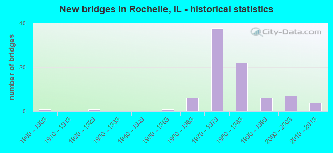
- New bridges - historical statistics
- 11900-1909
- 11920-1929
- 11950-1959
- 61960-1969
- 381970-1979
- 221980-1989
- 61990-1999
- 72000-2009
- 42010-2019
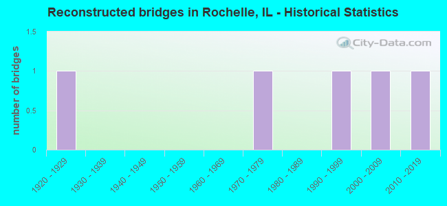
- Reconstructed bridges - Historical Statistics
- 11920-1929
- 01930-1939
- 01940-1949
- 01950-1959
- 01960-1969
- 11970-1979
- 01980-1989
- 11990-1999
- 12000-2009
- 12010-2019
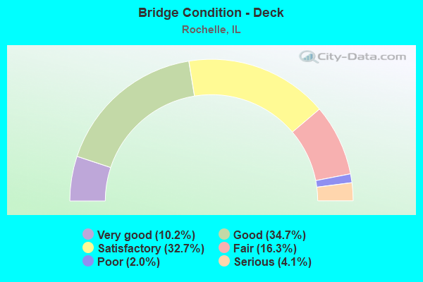
- Bridge Condition - Deck
- 10.2%Very good
- 34.7%Good
- 32.7%Satisfactory
- 16.3%Fair
- 2.0%Poor
- 4.1%Serious

- Bridge Condition - Superstructure
- 10.2%Very good
- 30.6%Good
- 36.7%Satisfactory
- 16.3%Fair
- 2.0%Poor
- 4.1%Serious
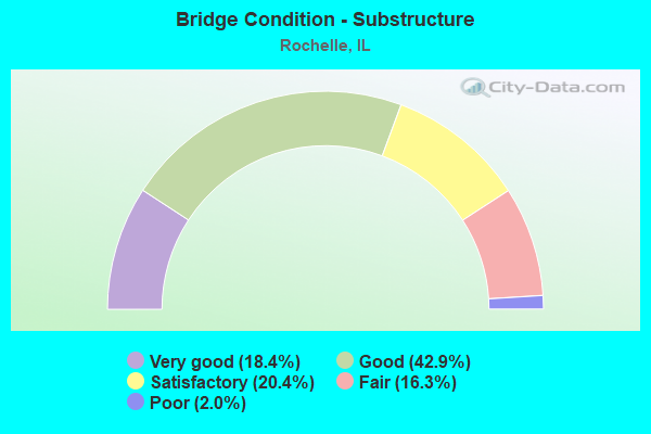
- Bridge Condition - Substructure
- 18.4%Very good
- 42.9%Good
- 20.4%Satisfactory
- 16.3%Fair
- 2.0%Poor
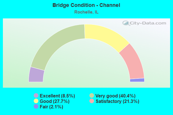
- Bridge Condition - Channel
- 8.5%Excellent
- 40.4%Very good
- 27.7%Good
- 21.3%Satisfactory
- 2.1%Fair
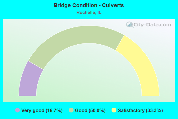
- Bridge Condition - Culverts
- 16.7%Very good
- 50.0%Good
- 33.3%Satisfactory
Find on map >> Show street view
Structure Number: 713314, Location: N EDGE ROCHELLE (Lat: 41.941269, Lng: -89.063378), Route carried "on" structure: Other road , Year Built: 1997, Status: Open, Structure Length: 2.04m (6.69ft), Average Daily Traffic: 4,000 (year 2017), Truck Traffic: 5%, Average Future Daily Traffic: 7,300 (year 2040), Design Load: HS 20, Features Intersected: KYTE RIVER, Facility Carried by Structure: FLAGG ROAD
Minimum Vertical Clearance: 30+ m (98+ ft), Kilometerpoint: 2.462, Lanes on structure: 2, Base Highway Network: Yes, Owner: City or Municipal Highway Agency, Approaching Roadway Width: 8.2m (26.9ft), Skew: 2 degrees, Material/Design: Prestressed concrete, Design/Construction: Stringer/Multi-beam, Number Of Spans In Main Unit: 1, Length of Maximum Span: 18.7m (61.4ft), Curb-To-Curb Width: 9.0m (29.5ft), Out-to-Out Width: 9.0m (29.5ft)
Condition: Deck: Very good, Superstructure: Very good, Substructure: Very good, Channel: Very good, Operating Rating: 44.1 metric tons, Method Used To Determine Operating Rating: Assigned rating based on Load Factor Design (LFD) reported by rating factor (RF) using MS18 loading, Inventory Rating: 32.4 metric tons, Method Used To Determine Inventory Rating: Assigned rating based on Load Factor Design (LFD) reported by rating factor (RF) using MS18 loading, Structural Evaluation: Equal to present desirable criteria, Deck Geometry: Meets minimum limits, Waterway Adequacy: Superior to present desirable criteria, Approach Roadway Alignment: Superior to present desirable criteria, Designated Inspection Frequency: Every 48 months, Inspection Date: March 2020, Deck Structure Type: Concrete Cast-file-Place, Wearing Surface/Protective System: Deck Protection: Epoxy Coated Reinforcing
Find on map >> Show street view
Structure Number: 713326, Location: .93MI S OF THORP RD (Lat: 41.897839, Lng: -89.131419), Route carried "on" structure: County highway , Year Built: 2006, Status: Open, Structure Length: 8.76m (28.74ft), Average Daily Traffic: 100 (year 2017), Truck Traffic: 24%, Average Future Daily Traffic: 350 (year 2040), Design Load: HS 20, Features Intersected: UNION PACIF RR, Facility Carried by Structure: THORPE RD
Minimum Vertical Clearance: 30+ m (98+ ft), Kilometerpoint: 1.497, Lanes on structure: 2, Owner: Town or Township Highway Agency, Approaching Roadway Width: 12.2m (40.0ft), Skew: 2 degrees, Material/Design: Prestressed concrete, Design/Construction: Stringer/Multi-beam, Number Of Spans In Main Unit: 3, Length of Maximum Span: 40.4m (132.5ft), Curb-To-Curb Width: 12.2m (40.0ft), Out-to-Out Width: 13.2m (43.3ft)
Condition: Deck: Very good, Superstructure: Very good, Substructure: Very good, Operating Rating: 44.1 metric tons, Method Used To Determine Operating Rating: Assigned rating based on Load Factor Design (LFD) reported by rating factor (RF) using MS18 loading, Inventory Rating: 32.4 metric tons, Method Used To Determine Inventory Rating: Assigned rating based on Load Factor Design (LFD) reported by rating factor (RF) using MS18 loading, Structural Evaluation: Equal to present desirable criteria, Deck Geometry: Superior to present desirable criteria, Underclear: Equal to present desirable criteria, Approach Roadway Alignment: Equal to present desirable criteria, Designated Inspection Frequency: Every 24 months, Inspection Date: July 2021, Deck Structure Type: Concrete Cast-file-Place, Wearing Surface/Protective System: Deck Protection: Epoxy Coated Reinforcing
Find on map >> Show street view
Structure Number: 713333, Location: 1.2MI E OF IL251 (Lat: 41.897972, Lng: -89.042947), Route carried "on" structure: Other road , Year Built: 2010, Status: Open, Structure Length: 6.88m (22.57ft), Average Daily Traffic: 1,700 (year 2020), Truck Traffic: 39%, Average Future Daily Traffic: 17,300 (year 2040), Design Load: HS 25 or greater, Features Intersected: BNSF RAILROAD, Facility Carried by Structure: STEWARD RD
Minimum Vertical Clearance: 30+ m (98+ ft), Kilometerpoint: 2.108, Lanes on structure: 2, Lanes under structure: 2, Base Highway Network: Yes, Owner: City or Municipal Highway Agency, Approaching Roadway Width: 12.2m (40.0ft), Skew: 1 degrees, Material/Design: Steel continuous, Design/Construction: Stringer/Multi-beam, Number Of Spans In Main Unit: 2, Length of Maximum Span: 33.8m (110.9ft), Curb-To-Curb Width: 12.2m (40.0ft), Out-to-Out Width: 13.2m (43.3ft)
Condition: Deck: Fair, Superstructure: Good, Substructure: Good, Operating Rating: 44.1 metric tons, Method Used To Determine Operating Rating: Assigned rating based on Load Factor Design (LFD) reported by rating factor (RF) using MS18 loading, Inventory Rating: 32.4 metric tons, Method Used To Determine Inventory Rating: Assigned rating based on Load Factor Design (LFD) reported by rating factor (RF) using MS18 loading, Structural Evaluation: Better than present minimum criteria, Deck Geometry: Better than present minimum criteria, Approach Roadway Alignment: Equal to present desirable criteria, Designated Inspection Frequency: Every 24 months, Inspection Date: October 2021, Deck Structure Type: Concrete Cast-file-Place, Wearing Surface/Protective System: Deck Protection: Epoxy Coated Reinforcing
Find on map >> Show street view
Structure Number: 715035, Location: 1.5 W. FLAGG CENTER (Lat: 41.945478, Lng: -89.151539), Route carried "on" structure: County highway , Year Built: 1963, Status: Open, Structure Length: 0.98m (3.22ft), Average Daily Traffic: 1,200 (year 2017), Truck Traffic: 7%, Average Future Daily Traffic: 2,100 (year 2040), Design Load: HS 15, Features Intersected: BR. KYTE CREEK, Facility Carried by Structure: SKARE RD.
Minimum Vertical Clearance: 30+ m (98+ ft), Kilometerpoint: 9.801, Lanes on structure: 2, Owner: Town or Township Highway Agency, Approaching Roadway Width: 9.1m (29.9ft), Material/Design: Concrete, Design/Construction: Culvert, Number Of Spans In Main Unit: 3, Length of Maximum Span: 3.0m (9.8ft), Curb-To-Curb Width: 7.9m (25.9ft), Out-to-Out Width: 8.4m (27.6ft)
Condition: Channel: Good, Culverts: Good, Operating Rating: 40.5 metric tons, Method Used To Determine Operating Rating: Field evaluation and documented engineering judgment, Inventory Rating: 24.3 metric tons, Method Used To Determine Inventory Rating: Field evaluation and documented engineering judgment, Structural Evaluation: Equal to present minimum criteria, Deck Geometry: Meets minimum limits, Waterway Adequacy: Better than present minimum criteria, Approach Roadway Alignment: Equal to present desirable criteria, Designated Inspection Frequency: Every 24 months, Inspection Date: July 2021
Find on map >> Show street view
Structure Number: 715044, Location: 1.5 N.W. FLAGG CENTE (Lat: 41.947681, Lng: -89.138642), Route carried "on" structure: County highway , Year Built: 1971, Status: Open, Structure Length: 0.67m (2.20ft), Average Daily Traffic: 400 (year 2017), Truck Traffic: 16%, Average Future Daily Traffic: 500 (year 2040), Design Load: HS 15, Features Intersected: BR. KYTE CREEK, Facility Carried by Structure: FOWLER RD
Minimum Vertical Clearance: 30+ m (98+ ft), Kilometerpoint: 2.559, Lanes on structure: 2, Owner: Town or Township Highway Agency, Approaching Roadway Width: 6.1m (20.0ft), Skew: 3 degrees, Material/Design: Concrete, Design/Construction: Culvert, Number Of Spans In Main Unit: 2, Length of Maximum Span: 3.0m (9.8ft), Curb-To-Curb Width: 8.3m (27.2ft), Out-to-Out Width: 8.3m (27.2ft)
Condition: Channel: Satisfactory, Culverts: Satisfactory, Operating Rating: 35.3 metric tons, Method Used To Determine Operating Rating: Load Factor (LF) rating reported by rating factor (RF) method using MS18 loading, Inventory Rating: 21.1 metric tons, Method Used To Determine Inventory Rating: Load Factor (LF) rating reported by rating factor (RF) method using MS18 loading, Structural Evaluation: Equal to present minimum criteria, Deck Geometry: Somewhat better than minimum adequacy, Waterway Adequacy: Equal to present desirable criteria, Approach Roadway Alignment: Equal to present desirable criteria, Designated Inspection Frequency: Every 24 months, Inspection Date: July 2021
Find on map >> Show street view
Structure Number: 715125, Location: 1.5 MI NW ROCHELLE (Lat: 41.940814, Lng: -89.101311), Route carried "on" structure: County highway , Year Built: 2010, Status: Open, Structure Length: 0.69m (2.26ft), Average Daily Traffic: 4,450 (year 2017), Truck Traffic: 10%, Average Future Daily Traffic: 5,500 (year 2040), Design Load: HS 20, Features Intersected: DRY RUN CREEK, Facility Carried by Structure: FLAGG ROAD
Minimum Vertical Clearance: 30+ m (98+ ft), Kilometerpoint: 22.723, Lanes on structure: 2, Owner: County Highway Agency, Approaching Roadway Width: 8.5m (27.9ft), Skew: 1 degrees, Material/Design: Concrete, Design/Construction: Culvert, Number Of Spans In Main Unit: 2, Length of Maximum Span: 3.0m (9.8ft)
Condition: Channel: Satisfactory, Culverts: Very good, Operating Rating: 44.1 metric tons, Method Used To Determine Operating Rating: Assigned rating based on Load Factor Design (LFD) reported by rating factor (RF) using MS18 loading, Inventory Rating: 32.4 metric tons, Method Used To Determine Inventory Rating: Assigned rating based on Load Factor Design (LFD) reported by rating factor (RF) using MS18 loading, Structural Evaluation: Equal to present desirable criteria, Waterway Adequacy: Superior to present desirable criteria, Approach Roadway Alignment: Equal to present desirable criteria, Designated Inspection Frequency: Every 48 months, Inspection Date: July 2021
Find on map >> Show street view
Structure Number: 716005, Location: ROCHELLE (Lat: 41.926147, Lng: -89.058650), Route carried "on" structure: Other road , Year Built: 1966, Status: Posted for load, Structure Length: 1.74m (5.71ft), Average Daily Traffic: 1,550 (year 2017), Truck Traffic: 6%, Average Future Daily Traffic: 1,700 (year 2040), Features Intersected: KYTE CREEK, Facility Carried by Structure: SEVENTH AVENUE
Minimum Vertical Clearance: 30+ m (98+ ft), Kilometerpoint: 0.821, Lanes on structure: 2, Owner: City or Municipal Highway Agency, Approaching Roadway Width: 10.7m (35.1ft), Material/Design: Prestressed concrete, Design/Construction: Box Beam or Girders - Multiple, Number Of Spans In Main Unit: 1, Length of Maximum Span: 16.8m (55.1ft), Curb or Sidewalk Widths: Left: 1.2m (3.9ft), Right: 1.2m (3.9ft), Curb-To-Curb Width: 8.8m (28.9ft), Out-to-Out Width: 11.9m (39.0ft)
Condition: Deck: Serious, Superstructure: Serious, Substructure: Fair, Channel: Satisfactory, Operating Rating: 20.1 metric tons, Method Used To Determine Operating Rating: Load Factor (LF) rating reported by rating factor (RF) method using MS18 loading, Inventory Rating: 5.2 metric tons, Method Used To Determine Inventory Rating: Load Factor (LF) rating reported by rating factor (RF) method using MS18 loading, Structural Evaluation: High priority of corrective action, Deck Geometry: Somewhat better than minimum adequacy, Waterway Adequacy: Equal to present minimum criteria, Approach Roadway Alignment: Equal to present desirable criteria, Bridge Posting: Required (Relationship of Operating Rating to Maximum Legal Load: > 39.9% below), Designated Inspection Frequency: Every 24 months, Other Special Inspection Frequency: Every 12 months, Inspection Date: March 2020, Other Special Inspection Date: Febuary 2021, Deck Structure Type: Concrete Precast Panels, Wearing Surface/Protective System: Wearing Surface: Bituminous
Find on map >> Show street view
Structure Number: 716007, Location: ROCHELLE S 2ND ST (Lat: 41.919300, Lng: -89.061950), Route carried "on" structure: City street , Year Built: 1975, Status: Temporarily open, Structure Length: 1.86m (6.10ft), Average Daily Traffic: 175 (year 2017), Truck Traffic: 9%, Average Future Daily Traffic: 75 (year 2040), Design Load: HS 20, Features Intersected: KYTE CREEK, Facility Carried by Structure: SO SECOND STREET
Minimum Vertical Clearance: 30+ m (98+ ft), Kilometerpoint: 0.032, Lanes on structure: 2, Owner: City or Municipal Highway Agency, Approaching Roadway Width: 7.3m (24.0ft), Skew: 2 degrees, Material/Design: Prestressed concrete, Design/Construction: Box Beam or Girders - Multiple, Number Of Spans In Main Unit: 1, Length of Maximum Span: 18.0m (59.1ft), Curb or Sidewalk Widths: Left: 1.2m (3.9ft), Right: 0.0m, Curb-To-Curb Width: 7.3m (24.0ft), Out-to-Out Width: 9.1m (29.9ft)
Condition: Deck: Serious, Superstructure: Serious, Substructure: Fair, Channel: Very good, Operating Rating: 42.8 metric tons, Method Used To Determine Operating Rating: Load Factor (LF) rating reported by rating factor (RF) method using MS18 loading, Structural Evaluation: High priority of corrective action, Deck Geometry: Somewhat better than minimum adequacy, Waterway Adequacy: Equal to present desirable criteria, Approach Roadway Alignment: Better than present minimum criteria, Designated Inspection Frequency: Every 24 months, Other Special Inspection Frequency: Every 12 months, Inspection Date: March 2020, Other Special Inspection Date: March 2021, Deck Structure Type: Concrete Precast Panels, Wearing Surface/Protective System: Wearing Surface: Bituminous
Find on map >> Show street view
Structure Number: 716008, Location: CARON RD ROCHELLE (Lat: 41.922628, Lng: -89.054361), Route carried "on" structure: Other road , Year Built: 1977, Status: Open, Structure Length: 1.22m (4.00ft), Average Daily Traffic: 2,300 (year 2017), Truck Traffic: 11%, Average Future Daily Traffic: 4,300 (year 2040), Design Load: HS 20, Features Intersected: BRANCH OF KYTE CREEK, Facility Carried by Structure: CARON RD
Minimum Vertical Clearance: 30+ m (98+ ft), Kilometerpoint: 2.044, Lanes on structure: 2, Base Highway Network: Yes, Owner: City or Municipal Highway Agency, Approaching Roadway Width: 11.0m (36.1ft), Skew: 2 degrees, Material/Design: Concrete, Design/Construction: Culvert, Number Of Spans In Main Unit: 3, Length of Maximum Span: 3.7m (12.1ft)
Condition: Channel: Good, Culverts: Very good, Operating Rating: 44.4 metric tons, Method Used To Determine Operating Rating: Assigned rating based on Load Factor Design (LFD) reported by rating factor (RF) using MS18 loading, Inventory Rating: 32.4 metric tons, Method Used To Determine Inventory Rating: Assigned rating based on Load Factor Design (LFD) reported by rating factor (RF) using MS18 loading, Structural Evaluation: Equal to present desirable criteria, Waterway Adequacy: Equal to present desirable criteria, Approach Roadway Alignment: Equal to present desirable criteria, Designated Inspection Frequency: Every 48 months, Inspection Date: March 2020, Wearing Surface/Protective System: Wearing Surface: Bituminous
Find on map >> Show street view
Structure Number: 716009, Location: ROCHELLE 1ST. AVE. (Lat: 41.919600, Lng: -89.059003), Route carried "on" structure: Other road , Year Built: 1978, Status: Open, Structure Length: 2.26m (7.41ft), Average Daily Traffic: 1,550 (year 2017), Truck Traffic: 17%, Average Future Daily Traffic: 3,400 (year 2040), Design Load: HS 20, Features Intersected: KYTE CREEK, Facility Carried by Structure: FIRST AVENUE
Minimum Vertical Clearance: 30+ m (98+ ft), Kilometerpoint: 1.400, Lanes on structure: 2, Owner: City or Municipal Highway Agency, Approaching Roadway Width: 9.8m (32.2ft), Skew: 3 degrees, Material/Design: Prestressed concrete, Design/Construction: Box Beam or Girders - Multiple, Number Of Spans In Main Unit: 1, Length of Maximum Span: 21.6m (70.9ft), Curb-To-Curb Width: 9.9m (32.5ft), Out-to-Out Width: 10.1m (33.1ft)
Condition: Deck: Poor, Superstructure: Poor, Substructure: Fair, Channel: Good, Operating Rating: 42.8 metric tons, Method Used To Determine Operating Rating: Load Factor (LF) rating reported by rating factor (RF) method using MS18 loading, Inventory Rating: 13.9 metric tons, Method Used To Determine Inventory Rating: Load Factor (LF) rating reported by rating factor (RF) method using MS18 loading, Structural Evaluation: Meets minimum limits, Deck Geometry: Somewhat better than minimum adequacy, Waterway Adequacy: Equal to present desirable criteria, Approach Roadway Alignment: Equal to present desirable criteria, Designated Inspection Frequency: Every 24 months, Inspection Date: March 2020, Deck Structure Type: Concrete Precast Panels, Wearing Surface/Protective System: Wearing Surface: Bituminous
Find on map >> Show street view
Structure Number: 71601, Location: IN ROCHELLE (Lat: 41.918406, Lng: -89.064039), Route carried "on" structure: Other road , Year Built: 1990, Status: Open, Structure Length: 2.75m (9.02ft), Average Daily Traffic: 2,450 (year 2017), Truck Traffic: 4%, Average Future Daily Traffic: 2,600 (year 2040), Design Load: HS 20, Features Intersected: KYTE CREEK, Facility Carried by Structure: SOUTH MAIN ST
Minimum Vertical Clearance: 30+ m (98+ ft), Kilometerpoint: 1.191, Lanes on structure: 2, Owner: City or Municipal Highway Agency, Approaching Roadway Width: 12.2m (40.0ft), Material/Design: Prestressed concrete, Design/Construction: Box Beam or Girders - Multiple, Number Of Spans In Main Unit: 3, Length of Maximum Span: 9.2m (30.2ft), Curb or Sidewalk Widths: Left: 0.0m, Right: 1.7m (5.6ft), Curb-To-Curb Width: 12.8m (42.0ft), Out-to-Out Width: 15.5m (50.9ft)
Condition: Deck: Fair, Superstructure: Fair, Substructure: Fair, Channel: Good, Operating Rating: 44.4 metric tons, Method Used To Determine Operating Rating: Assigned rating based on Load Factor Design (LFD) reported by rating factor (RF) using MS18 loading, Inventory Rating: 32.4 metric tons, Method Used To Determine Inventory Rating: Assigned rating based on Load Factor Design (LFD) reported by rating factor (RF) using MS18 loading, Structural Evaluation: Somewhat better than minimum adequacy, Deck Geometry: Equal to present minimum criteria, Waterway Adequacy: Equal to present desirable criteria, Approach Roadway Alignment: Equal to present desirable criteria, Designated Inspection Frequency: Every 24 months, Inspection Date: March 2020, Deck Structure Type: Concrete Precast Panels, Wearing Surface/Protective System: Wearing Surface: Integral Concrete
Find on map >> Show street view
Structure Number: 716011, Location: SW SEC 20 T40N R2E (Lat: 41.924369, Lng: -89.033886), Route carried "on" structure: City street , Year Built: 2001, Status: Open, Structure Length: 6.72m (22.05ft), Average Daily Traffic: 2,200 (year 2017), Truck Traffic: 30%, Average Future Daily Traffic: 2,500 (year 2040), Design Load: HS 20, Features Intersected: UP RR & RILEY DITCH, Facility Carried by Structure: DEMENT ROAD
Minimum Vertical Clearance: 30+ m (98+ ft), Kilometerpoint: 1.110, Lanes on structure: 2, Owner: City or Municipal Highway Agency, Approaching Roadway Width: 12.9m (42.3ft), Material/Design: Prestressed concrete, Design/Construction: Stringer/Multi-beam, Number Of Spans In Main Unit: 3, Length of Maximum Span: 28.3m (92.8ft), Curb-To-Curb Width: 9.1m (29.9ft), Out-to-Out Width: 10.1m (33.1ft)
Condition: Deck: Satisfactory, Superstructure: Good, Substructure: Fair, Operating Rating: 44.1 metric tons, Method Used To Determine Operating Rating: Assigned rating based on Load Factor Design (LFD) reported by rating factor (RF) using MS18 loading, Inventory Rating: 32.4 metric tons, Method Used To Determine Inventory Rating: Assigned rating based on Load Factor Design (LFD) reported by rating factor (RF) using MS18 loading, Structural Evaluation: Somewhat better than minimum adequacy, Deck Geometry: Meets minimum limits, Underclear: Superior to present desirable criteria, Approach Roadway Alignment: Equal to present desirable criteria, Designated Inspection Frequency: Every 24 months, Inspection Date: March 2020, Deck Structure Type: Concrete Cast-file-Place, Wearing Surface/Protective System: Deck Protection: Epoxy Coated Reinforcing
Find on map >> Show street view
Structure Number: 716013, Location: EAST EDGE ROCHELLE (Lat: 41.919667, Lng: -89.053031), Route carried "on" structure: Other road , Year Built: 2004, Status: Open, Structure Length: 0.76m (2.49ft), Average Daily Traffic: 2,150 (year 2017), Truck Traffic: 26%, Average Future Daily Traffic: 3,400 (year 2040), Design Load: HS 20, Features Intersected: RYLEY DITCH, Facility Carried by Structure: FIRST AVE
Minimum Vertical Clearance: 30+ m (98+ ft), Kilometerpoint: 1.819, Lanes on structure: 2, Owner: City or Municipal Highway Agency, Approaching Roadway Width: 10.1m (33.1ft), Skew: 1 degrees, Material/Design: Aluminum, Iron, Design/Construction: Culvert, Number Of Spans In Main Unit: 1, Length of Maximum Span: 7.2m (23.6ft)
Condition: Channel: Very good, Culverts: Good, Operating Rating: 89.1 metric tons, Method Used To Determine Operating Rating: Load Factor (LF) rating reported by rating factor (RF) method using MS18 loading, Inventory Rating: 89.1 metric tons, Method Used To Determine Inventory Rating: Load Factor (LF) rating reported by rating factor (RF) method using MS18 loading, Structural Evaluation: Better than present minimum criteria, Waterway Adequacy: Equal to present desirable criteria, Approach Roadway Alignment: Equal to present desirable criteria, Designated Inspection Frequency: Every 24 months, Inspection Date: March 2020
Find on map >> Show street view
Structure Number: 716014, Location: S SIDE OF ROCHELLE (Lat: 41.905297, Lng: -89.074956), Route carried "on" structure: City street , Year Built: 2003, Status: Open, Structure Length: 2.87m (9.42ft), Average Daily Traffic: 1,800 (year 2017), Truck Traffic: 46%, Average Future Daily Traffic: 1,900 (year 2040), Design Load: HS 20, Features Intersected: KYTE RIVER, Facility Carried by Structure: INTERMODEL DR
Minimum Vertical Clearance: 30+ m (98+ ft), Kilometerpoint: 3.605, Lanes on structure: 3, Base Highway Network: Yes (Inventory Route: 4300000, Subroute: 35), Owner: City or Municipal Highway Agency, Approaching Roadway Width: 12.8m (42.0ft), Material/Design: Concrete, Design/Construction: Slab, Number Of Spans In Main Unit: 3, Length of Maximum Span: 9.8m (32.2ft), Curb or Sidewalk Widths: Left: 1.8m (5.9ft), Right: 0.0m, Curb-To-Curb Width: 14.0m (45.9ft), Out-to-Out Width: 16.8m (55.1ft)
Condition: Deck: Good, Superstructure: Good, Substructure: Satisfactory, Channel: Excellent, Operating Rating: 44.1 metric tons, Method Used To Determine Operating Rating: Assigned rating based on Load Factor Design (LFD) reported by rating factor (RF) using MS18 loading, Inventory Rating: 32.4 metric tons, Method Used To Determine Inventory Rating: Assigned rating based on Load Factor Design (LFD) reported by rating factor (RF) using MS18 loading, Structural Evaluation: Equal to present minimum criteria, Deck Geometry: Somewhat better than minimum adequacy, Waterway Adequacy: Superior to present desirable criteria, Approach Roadway Alignment: Equal to present desirable criteria, Designated Inspection Frequency: Every 24 months, Inspection Date: March 2020, Deck Structure Type: Concrete Cast-file-Place, Wearing Surface/Protective System: Deck Protection: Epoxy Coated Reinforcing
Find on map >> Show street view
Structure Number: 716015, Location: SW SIDE OF ROCHELLE (Lat: 41.905264, Lng: -89.081183), Route carried "on" structure: City street , Year Built: 2003, Status: Open, Structure Length: 1.19m (3.90ft), Average Daily Traffic: 900 (year 2017), Truck Traffic: 50%, Average Future Daily Traffic: 1,385 (year 2032), Design Load: HS 20, Features Intersected: FLAGG TRIB, Facility Carried by Structure: INTERMODAL DR.
Minimum Vertical Clearance: 30+ m (98+ ft), Kilometerpoint: 3.058, Lanes on structure: 2, Owner: City or Municipal Highway Agency, Approaching Roadway Width: 8.5m (27.9ft), Skew: 1 degrees, Material/Design: Concrete, Design/Construction: Slab, Number Of Spans In Main Unit: 1, Length of Maximum Span: 11.4m (37.4ft), Curb-To-Curb Width: 9.8m (32.2ft), Out-to-Out Width: 10.7m (35.1ft)
Condition: Deck: Good, Superstructure: Good, Substructure: Very good, Channel: Excellent, Operating Rating: 44.1 metric tons, Method Used To Determine Operating Rating: Assigned rating based on Load Factor Design (LFD) reported by rating factor (RF) using MS18 loading, Inventory Rating: 32.4 metric tons, Method Used To Determine Inventory Rating: Assigned rating based on Load Factor Design (LFD) reported by rating factor (RF) using MS18 loading, Structural Evaluation: Better than present minimum criteria, Deck Geometry: Equal to present minimum criteria, Waterway Adequacy: Superior to present desirable criteria, Approach Roadway Alignment: Equal to present desirable criteria, Designated Inspection Frequency: Every 48 months, Inspection Date: March 2020, Deck Structure Type: Concrete Cast-file-Place, Wearing Surface/Protective System: Deck Protection: Epoxy Coated Reinforcing
Find on map >> Show street view
Structure Number: 716016, Location: City of Rochelle (Lat: 41.930339, Lng: -89.059881), Route carried "on" structure: City street , Year Built: 2014, Status: Open, Structure Length: 2.23m (7.32ft), Average Daily Traffic: 1,050 (year 2017), Truck Traffic: 8%, Average Future Daily Traffic: 1,551 (year 2032), Design Load: HS 25 or greater, Features Intersected: Kyte Creek, Facility Carried by Structure: School Avenue
Minimum Vertical Clearance: 30+ m (98+ ft), Kilometerpoint: 0.241, Lanes on structure: 2, Owner: City or Municipal Highway Agency, Approaching Roadway Width: 6.7m (22.0ft), Material/Design: Concrete continuous, Design/Construction: Slab, Number Of Spans In Main Unit: 3, Length of Maximum Span: 7.2m (23.6ft), Curb or Sidewalk Widths: Left: 1.5m (4.9ft), Right: 2.4m (7.9ft), Curb-To-Curb Width: 9.9m (32.5ft), Out-to-Out Width: 15.5m (50.9ft)
Condition: Deck: Very good, Superstructure: Very good, Substructure: Very good, Channel: Good, Operating Rating: 42.1 metric tons, Method Used To Determine Operating Rating: Assigned ratings based on Load and Resistance Factor Design (LRFD) reported by rating factor (RF) using HL93 loadings, Inventory Rating: 32.4 metric tons, Method Used To Determine Inventory Rating: Assigned ratings based on Load and Resistance Factor Design (LRFD) reported by rating factor (RF) using HL93 loadings, Structural Evaluation: Equal to present desirable criteria, Deck Geometry: Somewhat better than minimum adequacy, Waterway Adequacy: Equal to present minimum criteria, Approach Roadway Alignment: Equal to present minimum criteria, Designated Inspection Frequency: Every 48 months, Inspection Date: March 2018, Deck Structure Type: Concrete Cast-file-Place, Wearing Surface/Protective System: Deck Protection: Epoxy Coated Reinforcing
Find on map >> Show street view
Structure Number: 719913, Location: .5 MI S ROCHELLE (Lat: 41.900311, Lng: -89.068556), Route carried "on" structure: Interstate 88, Year Built: 1974, Status: Open, Structure Length: 4.79m (15.72ft), Average Daily Traffic: 7,350 (year 2020), Truck Traffic: 63%, Average Future Daily Traffic: 10,600 (year 2040), Design Load: HS 20, Features Intersected: ILL 251
Minimum Vertical Clearance: 30+ m (98+ ft), Kilometerpoint: 122.307, Lanes on structure: 2, Lanes under structure: 4, Base Highway Network: Yes, Toll: On toll road, Owner: State Toll Authority, Approaching Roadway Width: 14.0m (45.9ft), Material/Design: Prestressed concrete continuous, Design/Construction: Stringer/Multi-beam, Number Of Spans In Main Unit: 2, Length of Maximum Span: 23.5m (77.1ft), Curb-To-Curb Width: 12.0m (39.4ft), Out-to-Out Width: 13.0m (42.7ft)
Condition: Deck: Satisfactory, Superstructure: Fair, Substructure: Good, Operating Rating: 59.6 metric tons, Method Used To Determine Operating Rating: Load Factor (LF) rating reported by rating factor (RF) method using MS18 loading, Inventory Rating: 35.6 metric tons, Method Used To Determine Inventory Rating: Load Factor (LF) rating reported by rating factor (RF) method using MS18 loading, Structural Evaluation: Somewhat better than minimum adequacy, Deck Geometry: Equal to present minimum criteria, Underclear: Meets minimum limits, Approach Roadway Alignment: Equal to present desirable criteria, Designated Inspection Frequency: Every 24 months, Inspection Date: July 2020, Deck Structure Type: Concrete Precast Panels
Find on map >> Show street view
Structure Number: 719914, Location: .5 MI S ROCHELLE (Lat: 41.900308, Lng: -89.068319), Route carried "on" structure: Interstate 88, Year Built: 1974, Status: Open, Structure Length: 4.79m (15.72ft), Average Daily Traffic: 7,700 (year 2020), Truck Traffic: 62%, Average Future Daily Traffic: 13,600 (year 2040), Design Load: HS 20, Features Intersected: ILL 251
Minimum Vertical Clearance: 30+ m (98+ ft), Kilometerpoint: 122.323, Lanes on structure: 2, Lanes under structure: 4, Base Highway Network: Yes, Toll: On toll road, Owner: State Toll Authority, Approaching Roadway Width: 14.0m (45.9ft), Material/Design: Prestressed concrete continuous, Design/Construction: Stringer/Multi-beam, Number Of Spans In Main Unit: 2, Length of Maximum Span: 23.5m (77.1ft), Curb-To-Curb Width: 12.0m (39.4ft), Out-to-Out Width: 13.0m (42.7ft)
Condition: Deck: Satisfactory, Superstructure: Fair, Substructure: Good, Operating Rating: 73.9 metric tons, Method Used To Determine Operating Rating: Load Factor (LF) rating reported by rating factor (RF) method using MS18 loading, Inventory Rating: 44.4 metric tons, Method Used To Determine Inventory Rating: Load Factor (LF) rating reported by rating factor (RF) method using MS18 loading, Structural Evaluation: Somewhat better than minimum adequacy, Deck Geometry: Equal to present minimum criteria, Underclear: Meets minimum limits, Approach Roadway Alignment: Equal to present desirable criteria, Designated Inspection Frequency: Every 24 months, Inspection Date: July 2020, Deck Structure Type: Concrete Precast Panels
Find on map >> Show street view
Structure Number: 719915, Location: .7 MI E OF ILL 251 (Lat: 41.900631, Lng: -89.053781), Route carried "on" structure: Other road , Year Built: 1974, Status: Open, Structure Length: 6.92m (22.70ft), Average Daily Traffic: 1,000 (year 2017), Truck Traffic: 25%, Average Future Daily Traffic: 1,100 (year 2040), Design Load: HS 20, Features Intersected: I-88 (E-W TOLLWAY), Facility Carried by Structure: STEWARD RD (FAU545
Minimum Vertical Clearance: 30+ m (98+ ft), Kilometerpoint: 3.380, Lanes on structure: 2, Lanes under structure: 4, Owner: State Toll Authority, Approaching Roadway Width: 13.4m (44.0ft), Material/Design: Prestressed concrete, Design/Construction: Stringer/Multi-beam, Number Of Spans In Main Unit: 4, Length of Maximum Span: 24.1m (79.1ft), Curb-To-Curb Width: 13.0m (42.7ft), Out-to-Out Width: 13.9m (45.6ft)
Condition: Deck: Satisfactory, Superstructure: Satisfactory, Substructure: Good, Operating Rating: 68.4 metric tons, Method Used To Determine Operating Rating: Load Factor (LF) rating reported by rating factor (RF) method using MS18 loading, Inventory Rating: 41.1 metric tons, Method Used To Determine Inventory Rating: Load Factor (LF) rating reported by rating factor (RF) method using MS18 loading, Structural Evaluation: Equal to present minimum criteria, Deck Geometry: Superior to present desirable criteria, Underclear: Somewhat better than minimum adequacy, Approach Roadway Alignment: Equal to present desirable criteria, Designated Inspection Frequency: Every 24 months, Inspection Date: August 2020, Deck Structure Type: Concrete Precast Panels
Find on map >> Show street view
Structure Number: 719916, Location: 1.2 MI E OF ILL 251 (Lat: 41.901900, Lng: -89.044228), Route carried "on" structure: Interstate 88, Year Built: 1974, Status: Open, Structure Length: 9.45m (31.00ft), Average Daily Traffic: 7,700 (year 2020), Truck Traffic: 62%, Average Future Daily Traffic: 13,600 (year 2040), Design Load: HS 20, Features Intersected: FAU5458,CARON&BN RR
Minimum Vertical Clearance: 30+ m (98+ ft), Kilometerpoint: 124.270, Lanes on structure: 2, Lanes under structure: 2, Base Highway Network: Yes, Toll: On toll road, Owner: State Toll Authority, Approaching Roadway Width: 14.0m (45.9ft), Material/Design: Steel continuous, Design/Construction: Stringer/Multi-beam, Number Of Spans In Main Unit: 4, Length of Maximum Span: 31.1m (102.0ft), Curb-To-Curb Width: 12.0m (39.4ft), Out-to-Out Width: 13.0m (42.7ft)
Condition: Deck: Satisfactory, Superstructure: Satisfactory, Substructure: Good, Operating Rating: 47.6 metric tons, Method Used To Determine Operating Rating: Load Factor (LF) rating reported by rating factor (RF) method using MS18 loading, Inventory Rating: 28.5 metric tons, Method Used To Determine Inventory Rating: Load Factor (LF) rating reported by rating factor (RF) method using MS18 loading, Structural Evaluation: Equal to present minimum criteria, Deck Geometry: Equal to present minimum criteria, Underclear: Somewhat better than minimum adequacy, Approach Roadway Alignment: Equal to present desirable criteria, Designated Inspection Frequency: Every 24 months, Inspection Date: August 2020, Deck Structure Type: Concrete Cast-file-Place
Find on map >> Show street view
Structure Number: 719917, Location: 1.2 MI E OF ILL 251 (Lat: 41.901931, Lng: -89.044019), Route carried "on" structure: Interstate 88, Year Built: 1974, Status: Open, Structure Length: 9.45m (31.00ft), Average Daily Traffic: 7,700 (year 2020), Truck Traffic: 62%, Average Future Daily Traffic: 14,000 (year 2040), Design Load: HS 20, Features Intersected: FAU5458,CARON&BN RR
Minimum Vertical Clearance: 30+ m (98+ ft), Kilometerpoint: 124.286, Lanes on structure: 2, Lanes under structure: 2, Base Highway Network: Yes, Toll: On toll road, Owner: State Toll Authority, Approaching Roadway Width: 14.0m (45.9ft), Material/Design: Steel continuous, Design/Construction: Stringer/Multi-beam, Number Of Spans In Main Unit: 4, Length of Maximum Span: 31.1m (102.0ft), Curb-To-Curb Width: 12.0m (39.4ft), Out-to-Out Width: 13.0m (42.7ft)
Condition: Deck: Satisfactory, Superstructure: Satisfactory, Substructure: Good, Operating Rating: 47.6 metric tons, Method Used To Determine Operating Rating: Load Factor (LF) rating reported by rating factor (RF) method using MS18 loading, Inventory Rating: 28.5 metric tons, Method Used To Determine Inventory Rating: Load Factor (LF) rating reported by rating factor (RF) method using MS18 loading, Structural Evaluation: Equal to present minimum criteria, Deck Geometry: Equal to present minimum criteria, Underclear: Somewhat better than minimum adequacy, Approach Roadway Alignment: Equal to present desirable criteria, Designated Inspection Frequency: Every 24 months, Inspection Date: August 2020, Deck Structure Type: Concrete Cast-file-Place
Find on map >> Show street view
Structure Number: 719918, Location: 2 MI E ROCHELLE (Lat: 41.905181, Lng: -88.999714), Route carried "on" structure: County highway , Year Built: 1974, Status: Open, Structure Length: 6.68m (21.92ft), Average Daily Traffic: 400 (year 2017), Truck Traffic: 23%, Average Future Daily Traffic: 75 (year 2040), Design Load: HS 20, Features Intersected: I-88 (E-W TOLLWAY), Facility Carried by Structure: TR 372 MULFORD RD
Minimum Vertical Clearance: 30+ m (98+ ft), Kilometerpoint: 11.362, Lanes on structure: 2, Lanes under structure: 4, Owner: State Toll Authority, Approaching Roadway Width: 9.1m (29.9ft), Material/Design: Prestressed concrete, Design/Construction: Stringer/Multi-beam, Number Of Spans In Main Unit: 4, Length of Maximum Span: 23.8m (78.1ft), Curb-To-Curb Width: 8.1m (26.6ft), Out-to-Out Width: 9.1m (29.9ft)
Condition: Deck: Satisfactory, Superstructure: Satisfactory, Substructure: Good, Operating Rating: 72.9 metric tons, Method Used To Determine Operating Rating: Load Factor (LF) rating reported by rating factor (RF) method using MS18 loading, Inventory Rating: 43.7 metric tons, Method Used To Determine Inventory Rating: Load Factor (LF) rating reported by rating factor (RF) method using MS18 loading, Structural Evaluation: Equal to present minimum criteria, Deck Geometry: Somewhat better than minimum adequacy, Underclear: Somewhat better than minimum adequacy, Approach Roadway Alignment: Equal to present desirable criteria, Designated Inspection Frequency: Every 24 months, Inspection Date: August 2020, Deck Structure Type: Concrete Precast Panels
Find on map >> Show street view
Structure Number: 719919, Location: 3 MI E OF ROCHELLE (Lat: 41.905361, Lng: -88.980419), Route carried "on" structure: County highway , Year Built: 1974, Status: Open, Structure Length: 6.64m (21.78ft), Average Daily Traffic: 100 (year 2017), Truck Traffic: 7%, Average Future Daily Traffic: 350 (year 2040), Design Load: HS 20, Features Intersected: I-88 (E-W TOLLWAY), Facility Carried by Structure: TR 374 LOCUST RD
Minimum Vertical Clearance: 30+ m (98+ ft), Kilometerpoint: 1.625, Lanes on structure: 2, Lanes under structure: 4, Owner: State Toll Authority, Approaching Roadway Width: 9.1m (29.9ft), Material/Design: Prestressed concrete, Design/Construction: Stringer/Multi-beam, Number Of Spans In Main Unit: 4, Length of Maximum Span: 23.8m (78.1ft), Curb-To-Curb Width: 8.1m (26.6ft), Out-to-Out Width: 9.1m (29.9ft)
Condition: Deck: Good, Superstructure: Satisfactory, Substructure: Good, Operating Rating: 73.9 metric tons, Method Used To Determine Operating Rating: Load Factor (LF) rating reported by rating factor (RF) method using MS18 loading, Inventory Rating: 44.4 metric tons, Method Used To Determine Inventory Rating: Load Factor (LF) rating reported by rating factor (RF) method using MS18 loading, Structural Evaluation: Equal to present minimum criteria, Deck Geometry: Equal to present minimum criteria, Underclear: Somewhat better than minimum adequacy, Approach Roadway Alignment: Equal to present desirable criteria, Designated Inspection Frequency: Every 24 months, Inspection Date: August 2020, Deck Structure Type: Concrete Precast Panels
Find on map >> Show street view
Structure Number: 719921, Location: 1.2 MI W OF ILL 251 (Lat: 41.891803, Lng: -89.089203), Route carried "on" structure: Interstate 88, Year Built: 1972, Status: Open, Structure Length: 1.16m (3.81ft), Average Daily Traffic: 14,700 (year 2020), Truck Traffic: 63%, Average Future Daily Traffic: 19,400 (year 2040), Design Load: HS 20, Features Intersected: STREAM
Minimum Vertical Clearance: 30+ m (98+ ft), Kilometerpoint: 120.392, Lanes on structure: 4, Base Highway Network: Yes, Toll: On toll road, Owner: State Toll Authority, Approaching Roadway Width: 39.6m (129.9ft), Skew: 10 degrees, Material/Design: Concrete, Design/Construction: Culvert, Number Of Spans In Main Unit: 4, Length of Maximum Span: 2.0m (6.6ft)
Condition: Channel: Very good, Culverts: Satisfactory, Operating Rating: 89.1 metric tons, Method Used To Determine Operating Rating: Load Factor (LF) rating reported by rating factor (RF) method using MS18 loading, Inventory Rating: 89.1 metric tons, Method Used To Determine Inventory Rating: Load Factor (LF) rating reported by rating factor (RF) method using MS18 loading, Structural Evaluation: Equal to present minimum criteria, Waterway Adequacy: Equal to present desirable criteria, Approach Roadway Alignment: Equal to present desirable criteria, Designated Inspection Frequency: Every 24 months, Inspection Date: June 2019
Find on map >> Show street view
Structure Number: 719922, Location: .2 MI W OF ILL 251 (Lat: 41.899650, Lng: -89.073786), Route carried "on" structure: Interstate 88, Year Built: 1972, Status: Open, Structure Length: 0.97m (3.18ft), Average Daily Traffic: 14,700 (year 2020), Truck Traffic: 63%, Average Future Daily Traffic: 21,300 (year 2040), Design Load: HS 20, Features Intersected: STREAM
Minimum Vertical Clearance: 30+ m (98+ ft), Kilometerpoint: 122.065, Lanes on structure: 4, Base Highway Network: Yes, Toll: On toll road, Owner: State Toll Authority, Approaching Roadway Width: 39.6m (129.9ft), Skew: 10 degrees, Material/Design: Concrete, Design/Construction: Culvert, Number Of Spans In Main Unit: 4, Length of Maximum Span: 1.7m (5.6ft)
Condition: Channel: Very good, Culverts: Satisfactory, Operating Rating: 89.1 metric tons, Method Used To Determine Operating Rating: Load Factor (LF) rating reported by rating factor (RF) method using MS18 loading, Inventory Rating: 89.1 metric tons, Method Used To Determine Inventory Rating: Load Factor (LF) rating reported by rating factor (RF) method using MS18 loading, Structural Evaluation: Equal to present minimum criteria, Waterway Adequacy: Equal to present desirable criteria, Approach Roadway Alignment: Equal to present desirable criteria, Designated Inspection Frequency: Every 24 months, Inspection Date: July 2019
Find on map >> Show street view
Structure Number: 719923, Location: 0.2 MI W OF ILL 251 (Lat: 41.899364, Lng: -89.073347), Route carried "on" structure: Other road , Year Built: 1972, Status: Open, Structure Length: 1.01m (3.31ft), Average Daily Traffic: 450 (year 2020), Average Future Daily Traffic: 400 (year 2040), Design Load: HS 20, Features Intersected: STREAM, Facility Carried by Structure: SW RAMP I-88 & IL2
Minimum Vertical Clearance: 30+ m (98+ ft), Kilometerpoint: 0.370, Lanes on structure: 1, Base Highway Network: Yes (Inventory Route: 10088040, Subroute: 70), Toll: On toll road, Owner: State Toll Authority, Approaching Roadway Width: 39.6m (129.9ft), Material/Design: Concrete, Design/Construction: Culvert, Number Of Spans In Main Unit: 4, Length of Maximum Span: 1.7m (5.6ft)
Condition: Channel: Very good, Culverts: Good, Operating Rating: 89.1 metric tons, Method Used To Determine Operating Rating: Load Factor (LF) rating reported by rating factor (RF) method using MS18 loading, Inventory Rating: 89.1 metric tons, Method Used To Determine Inventory Rating: Load Factor (LF) rating reported by rating factor (RF) method using MS18 loading, Structural Evaluation: Better than present minimum criteria, Waterway Adequacy: Equal to present desirable criteria, Approach Roadway Alignment: Equal to present desirable criteria, Designated Inspection Frequency: Every 24 months, Inspection Date: July 2019
Find on map >> Show street view
Structure Number: 529937, Location: 3.5 MI E OF ASHTON (Lat: 41.875361, Lng: -89.150950), Route carried "under" structure: Interstate 88, Year Built: 1974, Structure Length: 0. m, Average Daily Traffic: 12,600 (year 2020), Truck Traffic: 62%, Features Intersected: I-88, Facility Carried by Structure: TR 220 BROOKLYN RD
Minimum Vertical Clearance: 5.16m (16.93ft), Kilometerpoint: 114.856, Lanes on structure: 2, Lanes under structure: 4, Material/Design: Prestressed concrete, Design/Construction: Stringer/Multi-beam, Length of Maximum Span: 27.4m (89.9ft)
Find on map >> Show street view
Structure Number: 529938, Location: 4 MI SW OF ROCHELLE (Lat: 41.881611, Lng: -89.131389), Route carried "under" structure: Interstate 88, Year Built: 1974, Structure Length: 0. m, Average Daily Traffic: 12,600 (year 2020), Truck Traffic: 62%, Features Intersected: I-88, Facility Carried by Structure: TR 222 THORPE RD
Minimum Vertical Clearance: 5.00m (16.40ft), Kilometerpoint: 116.626, Lanes on structure: 2, Lanes under structure: 4, Material/Design: Prestressed concrete, Design/Construction: Stringer/Multi-beam, Length of Maximum Span: 25.0m (82.0ft)
Find on map >> Show street view
Structure Number: 529941, Location: .5 MI SW OGLE CO LN (Lat: 41.886011, Lng: -89.112361), Route carried "under" structure: Interstate 88, Year Built: 1974, Structure Length: 0. m, Average Daily Traffic: 12,600 (year 2020), Truck Traffic: 62%, Features Intersected: I-88, Facility Carried by Structure: TR 232 BUSH GROVE
Minimum Vertical Clearance: 5.00m (16.40ft), Kilometerpoint: 118.284, Lanes on structure: 2, Lanes under structure: 4, Material/Design: Prestressed concrete, Design/Construction: Stringer/Multi-beam, Length of Maximum Span: 24.1m (79.1ft)
Find on map >> Show street view
Structure Number: 710057, Location: 1 MI N OF IL 38 (Lat: 41.949300, Lng: -89.024092), Route carried "under" structure: Interstate 39, Year Built: 1980, Structure Length: 0. m, Average Daily Traffic: 29,500 (year 2021), Truck Traffic: 34%, Features Intersected: I-39 & US 51, Facility Carried by Structure: TWOMBLY RD
Minimum Vertical Clearance: 4.90m (16.08ft), Kilometerpoint: 162.684, Lanes on structure: 2, Lanes under structure: 4, Material/Design: Prestressed concrete continuous, Design/Construction: Stringer/Multi-beam, Length of Maximum Span: 32.2m (105.6ft)
Find on map >> Show street view
Structure Number: 710058, Location: 2 MI E OF ROCHELLE (Lat: 41.934800, Lng: -89.023922), Route carried "under" structure: Interstate 39, Year Built: 1980, Structure Length: 0. m, Average Daily Traffic: 29,500 (year 2021), Truck Traffic: 34%, Features Intersected: I-39 & US 51, Facility Carried by Structure: ILL 38
Minimum Vertical Clearance: 4.88m (16.01ft), Kilometerpoint: 161.075, Lanes on structure: 4, Lanes under structure: 4, Material/Design: Steel continuous, Design/Construction: Stringer/Multi-beam, Length of Maximum Span: 32.2m (105.6ft)
Find on map >> Show street view
Structure Number: 710061, Location: 1.5 MI E OF ROCHELLE (Lat: 41.920331, Lng: -89.023764), Route carried "under" structure: Interstate 39, Year Built: 1980, Structure Length: 0. m, Average Daily Traffic: 29,600 (year 2021), Truck Traffic: 36%, Features Intersected: I-39 & US 51, Facility Carried by Structure: CRESTON RD
Minimum Vertical Clearance: 4.95m (16.24ft), Kilometerpoint: 159.466, Lanes on structure: 2, Lanes under structure: 4, Material/Design: Prestressed concrete continuous, Design/Construction: Stringer/Multi-beam, Length of Maximum Span: 32.5m (106.6ft)
Find on map >> Show street view
Structure Number: 710062, Location: 1 MI N OF LEE CO.LN. (Lat: 41.904950, Lng: -89.021225), Route carried "under" structure: Interstate 88, Year Built: 1981, Structure Length: 0. m, Average Daily Traffic: 15,400 (year 2020), Truck Traffic: 62%, Features Intersected: I-88(E-W TOLLWAY), Facility Carried by Structure: I-39 & US 51 SB
Minimum Vertical Clearance: 5.00m (16.40ft), Kilometerpoint: 126.250, Lanes on structure: 2, Lanes under structure: 4, Material/Design: Steel continuous, Design/Construction: Stringer/Multi-beam, Length of Maximum Span: 32.6m (107.0ft)
Find on map >> Show street view
Structure Number: 710063, Location: 1 MI N OF LEE CO.LN. (Lat: 41.904969, Lng: -89.020819), Route carried "under" structure: Interstate 88, Year Built: 1981, Structure Length: 0. m, Average Daily Traffic: 18,100 (year 2020), Truck Traffic: 32%, Features Intersected: I-88(E-W TOLLWAY), Facility Carried by Structure: I-39 & US 51 NB
Minimum Vertical Clearance: 5.00m (16.40ft), Kilometerpoint: 126.298, Lanes on structure: 2, Lanes under structure: 4, Material/Design: Steel continuous, Design/Construction: Stringer/Multi-beam, Length of Maximum Span: 32.7m (107.3ft)
Find on map >> Show street view
Structure Number: 710064, Location: 2 MI E OF ROCHELLE (Lat: 41.897972, Lng: -89.016847), Route carried "under" structure: Interstate 39, Year Built: 1980, Structure Length: 0. m, Average Daily Traffic: 20,400 (year 2019), Truck Traffic: 37%, Features Intersected: I-39 & US 51, Facility Carried by Structure: RITCHIE RD
Minimum Vertical Clearance: 4.98m (16.34ft), Kilometerpoint: 156.875, Lanes on structure: 2, Lanes under structure: 4, Material/Design: Steel continuous, Design/Construction: Stringer/Multi-beam, Length of Maximum Span: 35.7m (117.1ft)
Find on map >> Show street view
Structure Number: 710066, Location: IN ROCHELLE (Lat: 41.921600, Lng: -89.068731), Route carried "under" structure: State highway 38, Year Built: 1981, Structure Length: 0. m, Average Daily Traffic: 1,850 (year 2021), Truck Traffic: 9%, Features Intersected: IL38,CNW&BN RR&1 AVE, Facility Carried by Structure: IL 251
Minimum Vertical Clearance: 4.93m (16.17ft), Kilometerpoint: 40.828, Lanes on structure: 2, Lanes under structure: 2, Material/Design: Prestressed concrete continuous, Design/Construction: Stringer/Multi-beam, Length of Maximum Span: 20.1m (65.9ft)
Find on map >> Show street view
Structure Number: 710066, Location: IN ROCHELLE (Lat: 41.919500, Lng: -89.068689), Route carried "under" structure: Other road , Year Built: 1981, Structure Length: 0. m, Average Daily Traffic: 2,300 (year 2017), Truck Traffic: 9%, Features Intersected: IL38,CNW&BN RR&1 AVE, Facility Carried by Structure: IL 251
Minimum Vertical Clearance: 4.88m (16.01ft), Kilometerpoint: 0.595, Lanes on structure: 2, Lanes under structure: 2, Material/Design: Prestressed concrete continuous, Design/Construction: Stringer/Multi-beam, Length of Maximum Span: 20.1m (65.9ft)
Find on map >> Show street view
Structure Number: 713333, Location: 1.2MI E OF IL251 (Lat: 41.898117, Lng: -89.042164), Route carried "under" structure: Other road , Year Built: 2010, Structure Length: 0. m, Average Daily Traffic: 900 (year 2017), Truck Traffic: 29%, Features Intersected: BNSF RAILROAD, Facility Carried by Structure: STEWARD RD
Minimum Vertical Clearance: 30+ m (98+ ft), Kilometerpoint: 4.973, Lanes on structure: 2, Lanes under structure: 2, Material/Design: Steel continuous, Design/Construction: Stringer/Multi-beam, Length of Maximum Span: 33.8m (110.9ft)
Find on map >> Show street view
Structure Number: 719913, Location: .5 MI S ROCHELLE (Lat: 41.900175, Lng: -89.068319), Route carried "under" structure: State highway 251, Year Built: 1974, Structure Length: 0. m, Average Daily Traffic: 6,850 (year 2021), Truck Traffic: 42%, Features Intersected: ILL 251, Facility Carried by Structure: I-88 EB E-W TOLLW
Minimum Vertical Clearance: 5.05m (16.57ft), Kilometerpoint: 147.203, Lanes on structure: 2, Lanes under structure: 4, Toll: On toll road, Material/Design: Prestressed concrete continuous, Design/Construction: Stringer/Multi-beam, Length of Maximum Span: 23.5m (77.1ft)
Find on map >> Show street view
Structure Number: 719914, Location: .5 MI S ROCHELLE (Lat: 41.900419, Lng: -89.068328), Route carried "under" structure: State highway 251, Year Built: 1974, Structure Length: 0. m, Average Daily Traffic: 5,100 (year 2021), Truck Traffic: 16%, Features Intersected: ILL 251, Facility Carried by Structure: I-88 WB E-W TOLLWA
Minimum Vertical Clearance: 5.11m (16.77ft), Kilometerpoint: 147.235, Lanes on structure: 2, Lanes under structure: 4, Toll: On toll road, Material/Design: Prestressed concrete continuous, Design/Construction: Stringer/Multi-beam, Length of Maximum Span: 23.5m (77.1ft)
Find on map >> Show street view
Structure Number: 719915, Location: .7 MI E OF ILL 251 (Lat: 41.900631, Lng: -89.053781), Route carried "under" structure: Interstate 88, Year Built: 1974, Structure Length: 0. m, Average Daily Traffic: 15,400 (year 2020), Truck Traffic: 62%, Features Intersected: I-88 (E-W TOLLWAY), Facility Carried by Structure: STEWARD RD (FAU545
Minimum Vertical Clearance: 5.21m (17.09ft), Kilometerpoint: 123.530, Lanes on structure: 2, Lanes under structure: 4, Material/Design: Prestressed concrete, Design/Construction: Stringer/Multi-beam, Length of Maximum Span: 24.1m (79.1ft)
Find on map >> Show street view
Structure Number: 719916, Location: 1.2 MI E OF ILL 251 (Lat: 41.901931, Lng: -89.044019), Route carried "under" structure: Other road , Year Built: 1974, Structure Length: 0. m, Average Daily Traffic: 900 (year 2017), Truck Traffic: 29%, Features Intersected: FAU5458,CARON&BN RR, Facility Carried by Structure: I-88 EB E-W TOLLWA
Minimum Vertical Clearance: 5.16m (16.93ft), Kilometerpoint: 4.522, Lanes on structure: 2, Lanes under structure: 2, Toll: On toll road, Material/Design: Steel continuous, Design/Construction: Stringer/Multi-beam, Length of Maximum Span: 31.1m (102.0ft)
Find on map >> Show street view
Structure Number: 719917, Location: 1.2 MI E OF ILL 251 (Lat: 41.902039, Lng: -89.044078), Route carried "under" structure: Other road , Year Built: 1974, Structure Length: 0. m, Average Daily Traffic: 900 (year 2017), Truck Traffic: 29%, Features Intersected: FAU5458,CARON&BN RR, Facility Carried by Structure: I-88 WB E-W TOLLWA
Minimum Vertical Clearance: 5.16m (16.93ft), Kilometerpoint: 4.506, Lanes on structure: 2, Lanes under structure: 2, Toll: On toll road, Material/Design: Steel continuous, Design/Construction: Stringer/Multi-beam, Length of Maximum Span: 31.1m (102.0ft)
Find on map >> Show street view
Structure Number: 719918, Location: 2 MI E ROCHELLE (Lat: 41.905181, Lng: -88.999714), Route carried "under" structure: Interstate 88, Year Built: 1974, Structure Length: 0. m, Average Daily Traffic: 18,100 (year 2020), Truck Traffic: 32%, Features Intersected: I-88 (E-W TOLLWAY), Facility Carried by Structure: TR 372 MULFORD RD
Minimum Vertical Clearance: 4.93m (16.17ft), Kilometerpoint: 128.068, Lanes on structure: 2, Lanes under structure: 4, Material/Design: Prestressed concrete, Design/Construction: Stringer/Multi-beam, Length of Maximum Span: 23.8m (78.1ft)
Find on map >> Show street view
Structure Number: 719919, Location: 3 MI E OF ROCHELLE (Lat: 41.905361, Lng: -88.980419), Route carried "under" structure: Interstate 88, Year Built: 1974, Structure Length: 0. m, Average Daily Traffic: 18,100 (year 2020), Truck Traffic: 32%, Features Intersected: I-88 (E-W TOLLWAY), Facility Carried by Structure: TR 374 LOCUST RD
Minimum Vertical Clearance: 4.93m (16.17ft), Kilometerpoint: 129.661, Lanes on structure: 2, Lanes under structure: 4, Material/Design: Prestressed concrete, Design/Construction: Stringer/Multi-beam, Length of Maximum Span: 23.8m (78.1ft)