Bridge Statistics for Rogers, Arkansas (AR)
Condition, Traffic, Stress, Structural Evaluation, Project Costs
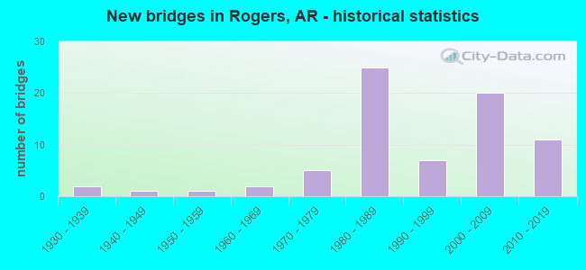
- New bridges - historical statistics
- 21930-1939
- 11940-1949
- 11950-1959
- 21960-1969
- 51970-1979
- 251980-1989
- 71990-1999
- 202000-2009
- 112010-2019
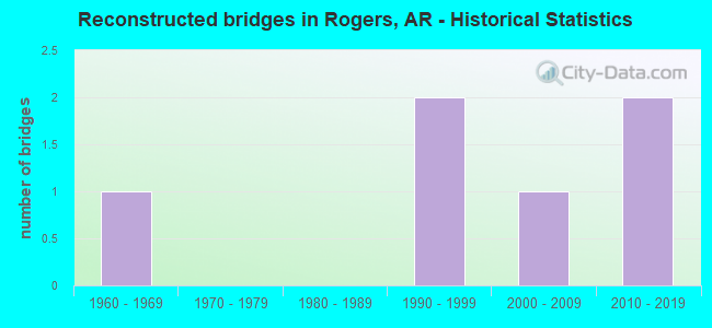
- Reconstructed bridges - Historical Statistics
- 11960-1969
- 01970-1979
- 01980-1989
- 21990-1999
- 12000-2009
- 22010-2019
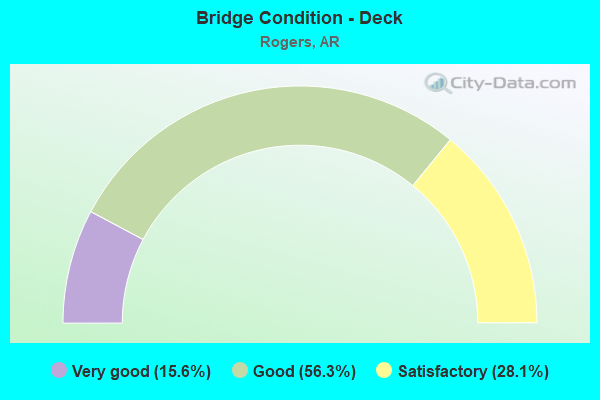
- Bridge Condition - Deck
- 15.6%Very good
- 56.3%Good
- 28.1%Satisfactory
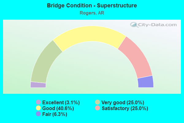
- Bridge Condition - Superstructure
- 3.1%Excellent
- 25.0%Very good
- 40.6%Good
- 25.0%Satisfactory
- 6.3%Fair
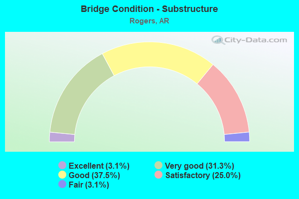
- Bridge Condition - Substructure
- 3.1%Excellent
- 31.3%Very good
- 37.5%Good
- 25.0%Satisfactory
- 3.1%Fair
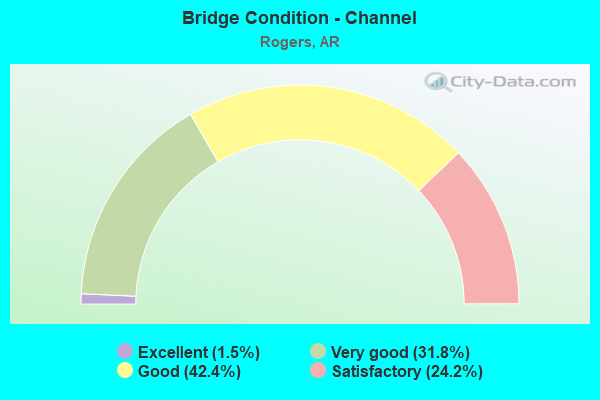
- Bridge Condition - Channel
- 1.5%Excellent
- 31.8%Very good
- 42.4%Good
- 24.2%Satisfactory
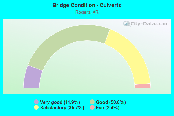
- Bridge Condition - Culverts
- 11.9%Very good
- 50.0%Good
- 35.7%Satisfactory
- 2.4%Fair
Find on map >> Show street view
Structure Number: 23857, Location: 0.4 MI S of I-49 (Lat: 36.291719, Lng: -94.171700), Route carried "on" structure: City street 4340, Year Built: 2016, Status: Open, Structure Length: 5.62m (18.44ft), Average Daily Traffic: 5,380 (year 2018), Truck Traffic: 1%, Average Future Daily Traffic: 5,500 (year 2026), Design Load: HL 93, Features Intersected: OSAGE CREEK, Facility Carried by Structure: Bellview Rd., Rgrs
Minimum Vertical Clearance: 30.44m (99.87ft), Kilometerpoint: 2.350, Lanes on structure: 4, Owner: City or Municipal Highway Agency, Approaching Roadway Width: 13.4m (44.0ft), Skew: 3 degrees, Material/Design: Concrete, Design/Construction: Frame, Number Of Spans In Main Unit: 4, Length of Maximum Span: 13.0m (42.7ft), Curb or Sidewalk Widths: Left: 3.0m (9.8ft), Right: 1.8m (5.9ft), Curb-To-Curb Width: 14.0m (45.9ft), Out-to-Out Width: 20.4m (66.9ft)
Condition: Deck: Good, Superstructure: Good, Substructure: Satisfactory, Channel: Very good, Operating Rating: 54.4 metric tons, Method Used To Determine Operating Rating: Load and Resistance Factor (LRFR), Inventory Rating: 32.7 metric tons, Method Used To Determine Inventory Rating: Load and Resistance Factor (LRFR), Structural Evaluation: Equal to present minimum criteria, Deck Geometry: High priority of replacement, Waterway Adequacy: Equal to present desirable criteria, Approach Roadway Alignment: Equal to present desirable criteria, Designated Inspection Frequency: Every 24 months, Critical Feature Inspection Frequency: Every 24 months, Inspection Date: October 2021, Wearing Surface/Protective System: Wearing Surface: Bituminous
Find on map >> Show street view
Structure Number: 239, Location: 1 Mi E. of A&M RR Tracks (Lat: 36.331958, Lng: -94.103897), Route carried "on" structure: City street 60540, Year Built: 2016, Status: Open, Structure Length: 1.44m (4.72ft), Average Daily Traffic: 2,900 (year 2018), Truck Traffic: 1%, Average Future Daily Traffic: 454 (year 2007), Design Load: HL 93, Features Intersected: S. Frk of Prairie Creek, Facility Carried by Structure: E.Walnut St-Rogers
Minimum Vertical Clearance: 30+ m (98+ ft), Kilometerpoint: 1.304, Lanes on structure: 2, Owner: City or Municipal Highway Agency, Approaching Roadway Width: 11.7m (38.4ft), Skew: 1 degrees, Material/Design: Concrete, Design/Construction: Culvert, Number Of Spans In Main Unit: 4, Length of Maximum Span: 3.7m (12.1ft), Curb or Sidewalk Widths: Left: 0.0m, Right: 3.0m (9.8ft), Curb-To-Curb Width: 11.7m (38.4ft), Out-to-Out Width: 23.3m (76.4ft)
Condition: Channel: Very good, Culverts: Good, Operating Rating: 49.0 metric tons, Method Used To Determine Operating Rating: Load and Resistance Factor (LRFR), Inventory Rating: 32.7 metric tons, Method Used To Determine Inventory Rating: Load and Resistance Factor (LRFR), Structural Evaluation: Better than present minimum criteria, Deck Geometry: Somewhat better than minimum adequacy, Waterway Adequacy: Equal to present desirable criteria, Approach Roadway Alignment: Better than present minimum criteria, Designated Inspection Frequency: Every 24 months, Critical Feature Inspection Frequency: Every 24 months, Inspection Date: December 2020
Find on map >> Show street view
Structure Number: 23901, Location: SO. OF LAKE ATALANTA (Lat: 36.334047, Lng: -94.103369), Route carried "on" structure: City street 31793, Year Built: 2016, Status: Open, Structure Length: 0.68m (2.23ft), Average Daily Traffic: 167 (year 1987), Truck Traffic: 1%, Average Future Daily Traffic: 236 (year 2007), Design Load: HS 20, Features Intersected: So. Frk of Prairie Creek, Facility Carried by Structure: Lake Atalanta Rd.
Minimum Vertical Clearance: 30+ m (98+ ft), Kilometerpoint: 0.016, Lanes on structure: 2, Owner: City or Municipal Highway Agency, Approaching Roadway Width: 7.3m (24.0ft), Skew: 4 degrees, Material/Design: Concrete, Design/Construction: Frame, Number Of Spans In Main Unit: 1, Length of Maximum Span: 6.8m (22.3ft), Curb-To-Curb Width: 7.3m (24.0ft), Out-to-Out Width: 20.2m (66.3ft)
Condition: Deck: Very good, Superstructure: Very good, Substructure: Very good, Channel: Very good, Operating Rating: 40.8 metric tons, Method Used To Determine Operating Rating: Load and Resistance Factor (LRFR), Inventory Rating: 31.8 metric tons, Method Used To Determine Inventory Rating: Load and Resistance Factor (LRFR), Structural Evaluation: Better than present minimum criteria, Deck Geometry: Somewhat better than minimum adequacy, Waterway Adequacy: Equal to present desirable criteria, Approach Roadway Alignment: Better than present minimum criteria, Designated Inspection Frequency: Every 24 months, Critical Feature Inspection Frequency: Every 24 months, Inspection Date: December 2020, Deck Structure Type: Concrete Precast Panels
Find on map >> Show street view
Structure Number: 2403, Location: 0.31 mi E of Hwy 112 (Lat: 36.293381, Lng: -94.222869), Route carried "on" structure: City street 45848, Year Built: 2017, Status: Not yet open, Structure Length: 10.36m (33.99ft), Average Daily Traffic: 12,000 (year 2020), Truck Traffic: 1%, Average Future Daily Traffic: 14,400 (year 2040), Design Load: HS 20, Features Intersected: Osage Creek, Facility Carried by Structure: Pleasant Grove Rd
Minimum Vertical Clearance: 30+ m (98+ ft), Kilometerpoint: 0.499, Lanes on structure: 2, Owner: City or Municipal Highway Agency, Approaching Roadway Width: 9.1m (29.9ft), Material/Design: Steel continuous, Design/Construction: Stringer/Multi-beam, Number Of Spans In Main Unit: 4, Length of Maximum Span: 29.0m (95.1ft), Curb or Sidewalk Widths: Left: 1.6m (5.2ft), Right: 1.6m (5.2ft), Curb-To-Curb Width: 8.8m (28.9ft), Out-to-Out Width: 13.1m (43.0ft)
Condition: Deck: Good, Superstructure: Very good, Substructure: Very good, Channel: Very good, Operating Rating: 54.4 metric tons, Method Used To Determine Operating Rating: Load Factor (LF), Inventory Rating: 32.7 metric tons, Method Used To Determine Inventory Rating: Load Factor (LF), Structural Evaluation: Equal to present desirable criteria, Deck Geometry: High priority of corrective action, Waterway Adequacy: Better than present minimum criteria, Approach Roadway Alignment: Better than present minimum criteria, Designated Inspection Frequency: Every 24 months, Critical Feature Inspection Frequency: Every 24 months, Inspection Date: September 2021, Deck Structure Type: Concrete Cast-file-Place, Wearing Surface/Protective System: Wearing Surface: Monolithic Concrete, Deck Protection: Epoxy Coated Reinforcing
Find on map >> Show street view
Structure Number: 24031, Location: 0.31 mi E of Hwy 112 (Lat: 36.293631, Lng: -94.222869), Route carried "on" structure: City street 45848, Year Built: 2019, Status: Open, Structure Length: 10.36m (33.99ft), Average Daily Traffic: 3,400 (year 2019), Truck Traffic: 1%, Average Future Daily Traffic: 4,080 (year 2040), Design Load: HL 93, Features Intersected: Osage Creek, Facility Carried by Structure: Pleasant Grove Rd.
Minimum Vertical Clearance: 30+ m (98+ ft), Kilometerpoint: 0.499, Lanes on structure: 2, Owner: City or Municipal Highway Agency, Approaching Roadway Width: 9.1m (29.9ft), Material/Design: Steel continuous, Design/Construction: Stringer/Multi-beam, Number Of Spans In Main Unit: 4, Length of Maximum Span: 29.0m (95.1ft), Curb or Sidewalk Widths: Left: 1.6m (5.2ft), Right: 1.6m (5.2ft), Curb-To-Curb Width: 8.8m (28.9ft), Out-to-Out Width: 13.1m (43.0ft)
Condition: Deck: Good, Superstructure: Very good, Substructure: Very good, Channel: Very good, Operating Rating: 39.9 metric tons, Method Used To Determine Operating Rating: Load and Resistance Factor (LRFR), Inventory Rating: 30.8 metric tons, Method Used To Determine Inventory Rating: Load and Resistance Factor (LRFR), Structural Evaluation: Better than present minimum criteria, Deck Geometry: High priority of corrective action, Waterway Adequacy: Equal to present desirable criteria, Approach Roadway Alignment: Better than present minimum criteria, Designated Inspection Frequency: Every 24 months, Critical Feature Inspection Frequency: Every 24 months, Inspection Date: September 2021, Deck Structure Type: Concrete Cast-file-Place, Wearing Surface/Protective System: Wearing Surface: Monolithic Concrete, Deck Protection: Epoxy Coated Reinforcing
Find on map >> Show street view
Structure Number: A5956, Location: 2.79 MI N SH 264 (Lat: 36.292069, Lng: -94.163158), Route carried "on" structure: Interstate 49, Year Built: 1982, Status: Open, Structure Length: 4.42m (14.50ft), Average Daily Traffic: 39,500 (year 2018), Truck Traffic: 12%, Average Future Daily Traffic: 57,500 (year 2033), Design Load: HS 20, Features Intersected: OSAGE CREEK
Minimum Vertical Clearance: 30+ m (98+ ft), Kilometerpoint: 129.938, Lanes on structure: 3, Owner: State Highway Agency, Approaching Roadway Width: 18.9m (62.0ft), Skew: 2 degrees, Material/Design: Prestressed concrete continuous, Design/Construction: Stringer/Multi-beam, Number Of Spans In Main Unit: 3, Length of Maximum Span: 17.4m (57.1ft), Curb-To-Curb Width: 18.9m (62.0ft), Out-to-Out Width: 19.8m (65.0ft)
Condition: Deck: Good, Superstructure: Good, Substructure: Very good, Channel: Satisfactory, Operating Rating: 54.4 metric tons, Method Used To Determine Operating Rating: Load Factor (LF), Inventory Rating: 32.7 metric tons, Method Used To Determine Inventory Rating: Load Factor (LF), Structural Evaluation: Better than present minimum criteria, Deck Geometry: Superior to present desirable criteria, Waterway Adequacy: Equal to present desirable criteria, Approach Roadway Alignment: Equal to present desirable criteria, Designated Inspection Frequency: Every 24 months, Critical Feature Inspection Frequency: Every 24 months, Inspection Date: June 2020, Deck Structure Type: Concrete Cast-file-Place, Wearing Surface/Protective System: Wearing Surface: Monolithic Concrete
Find on map >> Show street view
Structure Number: A5958, Location: 3.69 MI N SH 264 (Lat: 36.298689, Lng: -94.176478), Route carried "on" structure: Interstate 49, Year Built: 1982, Status: Open, Structure Length: 8.20m (26.90ft), Average Daily Traffic: 39,500 (year 2018), Truck Traffic: 12%, Average Future Daily Traffic: 57,500 (year 2033), Design Load: HS 20, Features Intersected: OSAGE CREEK
Minimum Vertical Clearance: 30+ m (98+ ft), Kilometerpoint: 131.371, Lanes on structure: 3, Base Highway Network: Yes, Owner: State Highway Agency, Approaching Roadway Width: 18.9m (62.0ft), Skew: 3 degrees, Material/Design: Steel continuous, Design/Construction: Stringer/Multi-beam, Number Of Spans In Main Unit: 5, Length of Maximum Span: 17.4m (57.1ft), Curb-To-Curb Width: 18.9m (62.0ft), Out-to-Out Width: 19.8m (65.0ft)
Condition: Deck: Satisfactory, Superstructure: Good, Substructure: Good, Channel: Good, Operating Rating: 54.4 metric tons, Method Used To Determine Operating Rating: Load Factor (LF), Inventory Rating: 32.7 metric tons, Method Used To Determine Inventory Rating: Load Factor (LF), Structural Evaluation: Better than present minimum criteria, Deck Geometry: Superior to present desirable criteria, Waterway Adequacy: Equal to present desirable criteria, Approach Roadway Alignment: Equal to present desirable criteria, Designated Inspection Frequency: Every 24 months, Critical Feature Inspection Frequency: Every 24 months, Inspection Date: June 2020, Deck Structure Type: Concrete Cast-file-Place, Wearing Surface/Protective System: Wearing Surface: Monolithic Concrete
Find on map >> Show street view
Structure Number: A596, Location: 4.97 MI N SH 264 (Lat: 36.314631, Lng: -94.185269), Route carried "on" structure: Interstate 49, Year Built: 1982, Status: Open, Structure Length: 12.22m (40.09ft), Average Daily Traffic: 25,500 (year 2018), Truck Traffic: 12%, Average Future Daily Traffic: 57,500 (year 2033), Design Load: HS 20, Features Intersected: New Hope Rd/ Osage Creek
Minimum Vertical Clearance: 30+ m (98+ ft), Kilometerpoint: 133.447, Lanes on structure: 2, Lanes under structure: 6, Base Highway Network: Yes, Owner: State Highway Agency, Approaching Roadway Width: 19.4m (63.6ft), Material/Design: Prestressed concrete continuous, Design/Construction: Stringer/Multi-beam, Number Of Spans In Main Unit: 7, Length of Maximum Span: 19.5m (64.0ft), Curb-To-Curb Width: 18.9m (62.0ft), Out-to-Out Width: 19.8m (65.0ft)
Condition: Deck: Good, Superstructure: Satisfactory, Substructure: Very good, Channel: Good, Operating Rating: 41.7 metric tons, Method Used To Determine Operating Rating: Load Factor (LF), Inventory Rating: 25.4 metric tons, Method Used To Determine Inventory Rating: Load Factor (LF), Structural Evaluation: Equal to present minimum criteria, Deck Geometry: Superior to present desirable criteria, Underclear: High priority of corrective action, Waterway Adequacy: Equal to present desirable criteria, Approach Roadway Alignment: Equal to present desirable criteria, Designated Inspection Frequency: Every 24 months, Critical Feature Inspection Frequency: Every 24 months, Inspection Date: August 2021, Deck Structure Type: Concrete Cast-file-Place, Wearing Surface/Protective System: Wearing Surface: Monolithic Concrete, Deck Protection: Epoxy Coated Reinforcing
Find on map >> Show street view
Structure Number: A5979, Location: 11.64 MI N WASH CO LINE (Lat: 36.356131, Lng: -94.178400), Route carried "on" structure: Interstate 49, Year Built: 1987, Status: Open, Structure Length: 5.43m (17.81ft), Average Daily Traffic: 34,500 (year 2018), Truck Traffic: 11%, Average Future Daily Traffic: 36,000 (year 2033), Design Load: HS 20, Features Intersected: US 62-SEC 2
Minimum Vertical Clearance: 30+ m (98+ ft), Kilometerpoint: 138.130, Lanes on structure: 2, Lanes under structure: 5, Base Highway Network: Yes, Owner: State Highway Agency, Approaching Roadway Width: 12.2m (40.0ft), Material/Design: Steel continuous, Design/Construction: Stringer/Multi-beam, Number Of Spans In Main Unit: 3, Length of Maximum Span: 24.1m (79.1ft), Curb-To-Curb Width: 8.2m (26.9ft), Out-to-Out Width: 13.0m (42.7ft)
Condition: Deck: Good, Superstructure: Satisfactory, Substructure: Satisfactory, Operating Rating: 54.4 metric tons, Method Used To Determine Operating Rating: Load Factor (LF), Inventory Rating: 32.7 metric tons, Method Used To Determine Inventory Rating: Load Factor (LF), Structural Evaluation: Equal to present minimum criteria, Deck Geometry: High priority of replacement, Underclear: Somewhat better than minimum adequacy, Approach Roadway Alignment: Equal to present desirable criteria, Designated Inspection Frequency: Every 24 months, Critical Feature Inspection Frequency: Every 24 months, Inspection Date: October 2021, Deck Structure Type: Concrete Cast-file-Place, Wearing Surface/Protective System: Wearing Surface: Monolithic Concrete, Deck Protection: Epoxy Coated Reinforcing
Find on map >> Show street view
Structure Number: B5956, Location: 2.79 MI N SH 264 (Lat: 36.292108, Lng: -94.162850), Route carried "on" structure: Interstate 49, Year Built: 1982, Status: Open, Structure Length: 4.42m (14.50ft), Average Daily Traffic: 39,500 (year 2018), Truck Traffic: 12%, Average Future Daily Traffic: 57,500 (year 2033), Design Load: HS 20, Features Intersected: OSAGE CREEK
Minimum Vertical Clearance: 30+ m (98+ ft), Kilometerpoint: 129.938, Lanes on structure: 3, Owner: State Highway Agency, Approaching Roadway Width: 18.9m (62.0ft), Skew: 2 degrees, Material/Design: Prestressed concrete continuous, Design/Construction: Stringer/Multi-beam, Number Of Spans In Main Unit: 3, Length of Maximum Span: 17.4m (57.1ft), Curb-To-Curb Width: 18.9m (62.0ft), Out-to-Out Width: 19.8m (65.0ft)
Condition: Deck: Good, Superstructure: Good, Substructure: Very good, Channel: Good, Operating Rating: 54.4 metric tons, Method Used To Determine Operating Rating: Load Factor (LF), Inventory Rating: 32.7 metric tons, Method Used To Determine Inventory Rating: Load Factor (LF), Structural Evaluation: Better than present minimum criteria, Deck Geometry: Superior to present desirable criteria, Waterway Adequacy: Equal to present desirable criteria, Approach Roadway Alignment: Equal to present desirable criteria, Designated Inspection Frequency: Every 24 months, Critical Feature Inspection Frequency: Every 24 months, Inspection Date: June 2020, Deck Structure Type: Concrete Cast-file-Place, Wearing Surface/Protective System: Wearing Surface: Monolithic Concrete
Find on map >> Show street view
Structure Number: B5958, Location: 3.69 MI N SH 264 (Lat: 36.298989, Lng: -94.176597), Route carried "on" structure: Interstate 49, Year Built: 1982, Status: Open, Structure Length: 8.20m (26.90ft), Average Daily Traffic: 39,500 (year 2018), Truck Traffic: 12%, Average Future Daily Traffic: 57,500 (year 2033), Design Load: HS 20, Features Intersected: OSAGE CREEK
Minimum Vertical Clearance: 30+ m (98+ ft), Kilometerpoint: 131.371, Lanes on structure: 3, Owner: State Highway Agency, Approaching Roadway Width: 18.9m (62.0ft), Skew: 3 degrees, Material/Design: Steel continuous, Design/Construction: Stringer/Multi-beam, Number Of Spans In Main Unit: 5, Length of Maximum Span: 17.4m (57.1ft), Curb-To-Curb Width: 18.9m (62.0ft), Out-to-Out Width: 19.8m (65.0ft)
Condition: Deck: Satisfactory, Superstructure: Good, Substructure: Good, Channel: Good, Operating Rating: 54.4 metric tons, Method Used To Determine Operating Rating: Load Factor (LF), Inventory Rating: 32.7 metric tons, Method Used To Determine Inventory Rating: Load Factor (LF), Structural Evaluation: Better than present minimum criteria, Deck Geometry: Superior to present desirable criteria, Waterway Adequacy: Equal to present desirable criteria, Approach Roadway Alignment: Equal to present desirable criteria, Designated Inspection Frequency: Every 24 months, Critical Feature Inspection Frequency: Every 24 months, Inspection Date: June 2020, Deck Structure Type: Concrete Cast-file-Place, Wearing Surface/Protective System: Wearing Surface: Monolithic Concrete
Find on map >> Show street view
Structure Number: B596, Location: 4.97 MI N SH 264 (Lat: 36.314489, Lng: -94.185000), Route carried "on" structure: Interstate 49, Year Built: 1982, Status: Open, Structure Length: 12.22m (40.09ft), Average Daily Traffic: 25,500 (year 2018), Truck Traffic: 12%, Average Future Daily Traffic: 57,500 (year 2033), Design Load: HS 20, Features Intersected: New Hope Rd/Osage Creek
Minimum Vertical Clearance: 30+ m (98+ ft), Kilometerpoint: 133.447, Lanes on structure: 2, Lanes under structure: 6, Base Highway Network: Yes, Owner: State Highway Agency, Approaching Roadway Width: 19.1m (62.7ft), Material/Design: Prestressed concrete continuous, Design/Construction: Stringer/Multi-beam, Number Of Spans In Main Unit: 7, Length of Maximum Span: 19.5m (64.0ft), Curb-To-Curb Width: 18.8m (61.7ft), Out-to-Out Width: 19.7m (64.6ft)
Condition: Deck: Satisfactory, Superstructure: Satisfactory, Substructure: Good, Channel: Good, Operating Rating: 41.7 metric tons, Method Used To Determine Operating Rating: Load Factor (LF), Inventory Rating: 25.4 metric tons, Method Used To Determine Inventory Rating: Load Factor (LF), Structural Evaluation: Equal to present minimum criteria, Deck Geometry: Superior to present desirable criteria, Underclear: High priority of corrective action, Waterway Adequacy: Equal to present desirable criteria, Approach Roadway Alignment: Equal to present desirable criteria, Designated Inspection Frequency: Every 24 months, Critical Feature Inspection Frequency: Every 24 months, Inspection Date: August 2021, Deck Structure Type: Concrete Cast-file-Place, Wearing Surface/Protective System: Wearing Surface: Monolithic Concrete, Deck Protection: Epoxy Coated Reinforcing
Find on map >> Show street view
Structure Number: B5979, Location: 11.64 MI N WASH CO LINE (Lat: 36.356131, Lng: -94.178111), Route carried "on" structure: Interstate 49, Year Built: 1987, Status: Open, Structure Length: 5.43m (17.81ft), Average Daily Traffic: 34,500 (year 2018), Truck Traffic: 11%, Average Future Daily Traffic: 36,000 (year 2033), Design Load: HS 20, Features Intersected: US 62-SEC 2
Minimum Vertical Clearance: 30+ m (98+ ft), Kilometerpoint: 138.130, Lanes on structure: 2, Lanes under structure: 4, Base Highway Network: Yes, Owner: State Highway Agency, Approaching Roadway Width: 12.2m (40.0ft), Material/Design: Steel continuous, Design/Construction: Stringer/Multi-beam, Number Of Spans In Main Unit: 3, Length of Maximum Span: 24.1m (79.1ft), Curb-To-Curb Width: 8.2m (26.9ft), Out-to-Out Width: 13.0m (42.7ft)
Condition: Deck: Good, Superstructure: Satisfactory, Substructure: Satisfactory, Operating Rating: 54.4 metric tons, Method Used To Determine Operating Rating: Load Factor (LF), Inventory Rating: 32.7 metric tons, Method Used To Determine Inventory Rating: Load Factor (LF), Structural Evaluation: Equal to present minimum criteria, Deck Geometry: High priority of replacement, Underclear: Somewhat better than minimum adequacy, Approach Roadway Alignment: Equal to present desirable criteria, Designated Inspection Frequency: Every 24 months, Critical Feature Inspection Frequency: Every 24 months, Inspection Date: October 2021, Deck Structure Type: Concrete Cast-file-Place, Wearing Surface/Protective System: Wearing Surface: Monolithic Concrete, Deck Protection: Epoxy Coated Reinforcing
Find on map >> Show street view
Structure Number: M036, Location: 1.91 MI E JCT US 62 (Lat: 36.344050, Lng: -94.089119), Route carried "on" structure: State highway 12, Year Built: 1964, Status: Open, Structure Length: 0.88m (2.89ft), Average Daily Traffic: 13,000 (year 2018), Truck Traffic: 2%, Average Future Daily Traffic: 18,334 (year 2028), Design Load: H 15, Features Intersected: PRAIRIE CREEK
Minimum Vertical Clearance: 30+ m (98+ ft), Kilometerpoint: 4.973, Lanes on structure: 2, Owner: State Highway Agency, Approaching Roadway Width: 7.9m (25.9ft), Skew: 3 degrees, Material/Design: Concrete, Design/Construction: Culvert, Number Of Spans In Main Unit: 2, Length of Maximum Span: 4.6m (15.1ft)
Condition: Channel: Good, Culverts: Satisfactory, Operating Rating: 31.8 metric tons, Method Used To Determine Operating Rating: Load Factor (LF), Inventory Rating: 19.1 metric tons, Method Used To Determine Inventory Rating: Load Factor (LF), Structural Evaluation: Meets minimum limits, Waterway Adequacy: Equal to present desirable criteria, Approach Roadway Alignment: Equal to present desirable criteria, Designated Inspection Frequency: Every 24 months, Critical Feature Inspection Frequency: Every 24 months, Inspection Date: Febuary 2022
Find on map >> Show street view
Structure Number: M0361, Location: 2.03 MI E JCT OF US 62 (Lat: 36.343981, Lng: -94.087050), Route carried "on" structure: State highway 12, Year Built: 1964, Status: Open, Structure Length: 0.64m (2.10ft), Average Daily Traffic: 13,000 (year 2018), Truck Traffic: 2%, Average Future Daily Traffic: 18,334 (year 2028), Design Load: H 15, Features Intersected: DITCH
Minimum Vertical Clearance: 30+ m (98+ ft), Kilometerpoint: 5.134, Lanes on structure: 2, Owner: State Highway Agency, Approaching Roadway Width: 7.9m (25.9ft), Material/Design: Concrete, Design/Construction: Culvert, Number Of Spans In Main Unit: 2, Length of Maximum Span: 3.0m (9.8ft)
Condition: Channel: Very good, Culverts: Good, Operating Rating: 26.3 metric tons, Method Used To Determine Operating Rating: Load Factor (LF), Inventory Rating: 16.3 metric tons, Method Used To Determine Inventory Rating: Load Factor (LF), Structural Evaluation: Meets minimum limits, Waterway Adequacy: Equal to present desirable criteria, Approach Roadway Alignment: Equal to present desirable criteria, Designated Inspection Frequency: Every 24 months, Critical Feature Inspection Frequency: Every 24 months, Inspection Date: Febuary 2022
Find on map >> Show street view
Structure Number: M1386, Location: 3.75 MI N JCT SH 264-US71 (Lat: 36.309014, Lng: -94.126403), Route carried "on" structure: Business US 71, Year Built: 1930, Year Reconstructed: 1968, Status: Open, Structure Length: 0.98m (3.22ft), Average Daily Traffic: 25,000 (year 2018), Truck Traffic: 1%, Average Future Daily Traffic: 29,616 (year 2028), Design Load: H 20, Features Intersected: DITCH
Minimum Vertical Clearance: 30+ m (98+ ft), Kilometerpoint: 11.088, Lanes on structure: 5, Owner: State Highway Agency, Approaching Roadway Width: 15.2m (49.9ft), Material/Design: Concrete, Design/Construction: Culvert, Number Of Spans In Main Unit: 3, Length of Maximum Span: 3.4m (11.2ft)
Condition: Channel: Good, Culverts: Satisfactory, Operating Rating: 41.7 metric tons, Method Used To Determine Operating Rating: Load Factor (LF), Inventory Rating: 25.4 metric tons, Method Used To Determine Inventory Rating: Load Factor (LF), Structural Evaluation: Equal to present minimum criteria, Waterway Adequacy: Equal to present desirable criteria, Approach Roadway Alignment: Equal to present desirable criteria, Designated Inspection Frequency: Every 24 months, Critical Feature Inspection Frequency: Every 24 months, Inspection Date: March 2020
Find on map >> Show street view
Structure Number: M1681, Location: 2.5 MI N JCT SH 62 & 94 (Lat: 36.395350, Lng: -94.118139), Route carried "on" structure: State highway 94, Year Built: 1948, Status: Open, Structure Length: 0.76m (2.49ft), Average Daily Traffic: 6,600 (year 2018), Truck Traffic: 1%, Average Future Daily Traffic: 7,475 (year 2028), Design Load: H 15, Features Intersected: BRUSH CREEK
Minimum Vertical Clearance: 30+ m (98+ ft), Kilometerpoint: 7.820, Lanes on structure: 2, Owner: State Highway Agency, Approaching Roadway Width: 7.3m (24.0ft), Material/Design: Concrete, Design/Construction: Culvert, Number Of Spans In Main Unit: 2, Length of Maximum Span: 4.0m (13.1ft)
Condition: Channel: Satisfactory, Culverts: Good, Operating Rating: 32.7 metric tons, Method Used To Determine Operating Rating: Load Factor (LF), Inventory Rating: 20.0 metric tons, Method Used To Determine Inventory Rating: Load Factor (LF), Structural Evaluation: Somewhat better than minimum adequacy, Waterway Adequacy: Equal to present desirable criteria, Approach Roadway Alignment: Equal to present desirable criteria, Designated Inspection Frequency: Every 24 months, Critical Feature Inspection Frequency: Every 24 months, Inspection Date: May 2020
Find on map >> Show street view
Structure Number: X0277, Location: .2 MI E JCT 71B & SH94 (Lat: 36.311578, Lng: -94.122847), Route carried "on" structure: State highway 94, Year Built: 1975, Status: Open, Structure Length: 1.04m (3.41ft), Average Daily Traffic: 17,816 (year 2018), Truck Traffic: 1%, Average Future Daily Traffic: 22,565 (year 2028), Design Load: H 20, Features Intersected: DRAINAGE DITCH
Minimum Vertical Clearance: 30+ m (98+ ft), Kilometerpoint: 11.954, Lanes on structure: 3, Owner: State Highway Agency, Approaching Roadway Width: 11.6m (38.1ft), Material/Design: Concrete, Design/Construction: Culvert, Number Of Spans In Main Unit: 4, Length of Maximum Span: 2.7m (8.9ft)
Condition: Channel: Very good, Culverts: Good, Operating Rating: 32.7 metric tons, Method Used To Determine Operating Rating: Load Factor (LF), Inventory Rating: 19.1 metric tons, Method Used To Determine Inventory Rating: Load Factor (LF), Structural Evaluation: Meets minimum limits, Waterway Adequacy: Equal to present desirable criteria, Approach Roadway Alignment: Equal to present desirable criteria, Designated Inspection Frequency: Every 48 months, Critical Feature Inspection Frequency: Every 24 months, Inspection Date: May 2018
Find on map >> Show street view
Structure Number: X0394, Location: .41 MI NO JCT 71B & 94 (Lat: 36.339492, Lng: -94.125592), Route carried "on" structure: State highway 94, Year Built: 1980, Status: Open, Structure Length: 0.79m (2.59ft), Average Daily Traffic: 18,000 (year 2018), Truck Traffic: 1%, Average Future Daily Traffic: 26,796 (year 2028), Design Load: H 20, Features Intersected: DITCH
Minimum Vertical Clearance: 30+ m (98+ ft), Kilometerpoint: 0.660, Lanes on structure: 5, Base Highway Network: Yes, Owner: State Highway Agency, Approaching Roadway Width: 15.2m (49.9ft), Skew: 1 degrees, Material/Design: Concrete, Design/Construction: Culvert, Number Of Spans In Main Unit: 3, Length of Maximum Span: 2.7m (8.9ft)
Condition: Channel: Very good, Culverts: Good, Operating Rating: 32.7 metric tons, Method Used To Determine Operating Rating: Load Factor (LF), Inventory Rating: 19.1 metric tons, Method Used To Determine Inventory Rating: Load Factor (LF), Structural Evaluation: Meets minimum limits, Waterway Adequacy: Equal to present desirable criteria, Approach Roadway Alignment: Equal to present desirable criteria, Designated Inspection Frequency: Every 48 months, Critical Feature Inspection Frequency: Every 24 months, Inspection Date: May 2018
Find on map >> Show street view
Structure Number: X0412, Location: 1.5 MI N JCT 71B & 94 (Lat: 36.354578, Lng: -94.124828), Route carried "on" structure: State highway 94, Year Built: 1980, Status: Open, Structure Length: 0.67m (2.20ft), Average Daily Traffic: 18,000 (year 2018), Truck Traffic: 1%, Average Future Daily Traffic: 26,796 (year 2028), Design Load: H 20, Features Intersected: DITCH
Minimum Vertical Clearance: 30+ m (98+ ft), Kilometerpoint: 2.350, Lanes on structure: 5, Base Highway Network: Yes, Owner: State Highway Agency, Approaching Roadway Width: 17.7m (58.1ft), Skew: 3 degrees, Material/Design: Concrete, Design/Construction: Culvert, Number Of Spans In Main Unit: 3, Length of Maximum Span: 2.4m (7.9ft)
Condition: Channel: Good, Culverts: Good, Operating Rating: 47.2 metric tons, Method Used To Determine Operating Rating: Load Factor (LF), Inventory Rating: 28.1 metric tons, Method Used To Determine Inventory Rating: Load Factor (LF), Structural Evaluation: Better than present minimum criteria, Waterway Adequacy: Equal to present desirable criteria, Approach Roadway Alignment: Equal to present desirable criteria, Designated Inspection Frequency: Every 48 months, Critical Feature Inspection Frequency: Every 24 months, Inspection Date: May 2018
Find on map >> Show street view
Structure Number: X0467, Location: .48 MI N US 71B (Lat: 36.340736, Lng: -94.134519), Route carried "on" structure: City street 64650, Year Built: 1982, Status: Open, Structure Length: 0.76m (2.49ft), Average Daily Traffic: 6,200 (year 2018), Truck Traffic: 1%, Average Future Daily Traffic: 291 (year 2007), Design Load: H 20, Features Intersected: OSAGE CREEK, Facility Carried by Structure: Rogers. N 13TH ST
Minimum Vertical Clearance: 30+ m (98+ ft), Kilometerpoint: 0.772, Lanes on structure: 4, Owner: City or Municipal Highway Agency, Approaching Roadway Width: 15.5m (50.9ft), Material/Design: Concrete, Design/Construction: Culvert, Number Of Spans In Main Unit: 3, Length of Maximum Span: 2.7m (8.9ft)
Condition: Channel: Satisfactory, Culverts: Satisfactory, Operating Rating: 30.8 metric tons, Method Used To Determine Operating Rating: Load Factor (LF), Inventory Rating: 19.1 metric tons, Method Used To Determine Inventory Rating: Load Factor (LF), Structural Evaluation: Meets minimum limits, Waterway Adequacy: Equal to present desirable criteria, Approach Roadway Alignment: Equal to present desirable criteria, Designated Inspection Frequency: Every 24 months, Critical Feature Inspection Frequency: Every 24 months, Inspection Date: March 2021
Find on map >> Show street view
Structure Number: X0511, Location: 4 MI N SH 264 (Lat: 36.301561, Lng: -94.180689), Route carried "on" structure: Interstate 49, Year Built: 1982, Status: Open, Structure Length: 0.98m (3.22ft), Average Daily Traffic: 81,099 (year 2018), Truck Traffic: 12%, Average Future Daily Traffic: 115,000 (year 2033), Design Load: H 20, Features Intersected: DITCH
Minimum Vertical Clearance: 30+ m (98+ ft), Kilometerpoint: 131.902, Lanes on structure: 4, Base Highway Network: Yes, Owner: State Highway Agency, Approaching Roadway Width: 24.4m (80.1ft), Material/Design: Concrete, Design/Construction: Culvert, Number Of Spans In Main Unit: 3, Length of Maximum Span: 3.4m (11.2ft)
Condition: Channel: Very good, Culverts: Satisfactory, Operating Rating: 37.2 metric tons, Method Used To Determine Operating Rating: Load Factor (LF), Inventory Rating: 22.7 metric tons, Method Used To Determine Inventory Rating: Load Factor (LF), Structural Evaluation: Somewhat better than minimum adequacy, Waterway Adequacy: Equal to present desirable criteria, Approach Roadway Alignment: Equal to present desirable criteria, Designated Inspection Frequency: Every 24 months, Critical Feature Inspection Frequency: Every 24 months, Inspection Date: April 2020
Find on map >> Show street view
Structure Number: X0512, Location: 2.4 MI E SH 112 (Lat: 36.316739, Lng: -94.186500), Route carried "on" structure: ServiceInterstate 49, Year Built: 1982, Status: Open, Structure Length: 3.26m (10.70ft), Average Daily Traffic: 27,000 (year 2018), Truck Traffic: 7%, Average Future Daily Traffic: 11,000 (year 2028), Design Load: H 20, Features Intersected: OSAGE CREEK
Minimum Vertical Clearance: 30+ m (98+ ft), Kilometerpoint: 133.688, Lanes on structure: 5, Owner: State Highway Agency, Approaching Roadway Width: 17.1m (56.1ft), Skew: 4 degrees, Material/Design: Concrete, Design/Construction: Culvert, Number Of Spans In Main Unit: 6, Length of Maximum Span: 5.5m (18.0ft)
Condition: Channel: Satisfactory, Culverts: Satisfactory, Operating Rating: 31.8 metric tons, Method Used To Determine Operating Rating: Load Factor (LF), Inventory Rating: 19.1 metric tons, Method Used To Determine Inventory Rating: Load Factor (LF), Structural Evaluation: Meets minimum limits, Waterway Adequacy: Equal to present desirable criteria, Approach Roadway Alignment: Equal to present desirable criteria, Designated Inspection Frequency: Every 24 months, Critical Feature Inspection Frequency: Every 24 months, Inspection Date: May 2020
Find on map >> Show street view
Structure Number: X0513, Location: 5.24 MI N SH 264 (Lat: 36.318531, Lng: -94.184861), Route carried "on" structure: Interstate 49, Year Built: 1982, Status: Open, Structure Length: 3.29m (10.79ft), Average Daily Traffic: 82,000 (year 2018), Truck Traffic: 1%, Average Future Daily Traffic: 127,300 (year 2038), Design Load: H 20, Features Intersected: OSAGE CREEK
Minimum Vertical Clearance: 30+ m (98+ ft), Kilometerpoint: 133.881, Lanes on structure: 6, Owner: State Highway Agency, Approaching Roadway Width: 28.7m (94.2ft), Skew: 4 degrees, Material/Design: Concrete, Design/Construction: Culvert, Number Of Spans In Main Unit: 6, Length of Maximum Span: 5.5m (18.0ft)
Condition: Channel: Satisfactory, Culverts: Satisfactory, Operating Rating: 39.0 metric tons, Method Used To Determine Operating Rating: Load Factor (LF), Inventory Rating: 23.6 metric tons, Method Used To Determine Inventory Rating: Load Factor (LF), Structural Evaluation: Somewhat better than minimum adequacy, Waterway Adequacy: Equal to present desirable criteria, Approach Roadway Alignment: Equal to present desirable criteria, Designated Inspection Frequency: Every 24 months, Critical Feature Inspection Frequency: Every 24 months, Inspection Date: April 2020
Find on map >> Show street view
Structure Number: X0725, Location: .75 MI N JCT 71B & 49 (Lat: 36.345781, Lng: -94.180289), Route carried "on" structure: Interstate 49, Year Built: 1989, Status: Open, Structure Length: 1.83m (6.00ft), Average Daily Traffic: 69,000 (year 2018), Truck Traffic: 1%, Average Future Daily Traffic: 107,100 (year 2038), Design Load: H 20, Features Intersected: DITCH
Minimum Vertical Clearance: 30+ m (98+ ft), Kilometerpoint: 136.987, Lanes on structure: 6, Base Highway Network: Yes, Owner: State Highway Agency, Approaching Roadway Width: 19.2m (63.0ft), Skew: 4 degrees, Material/Design: Concrete, Design/Construction: Culvert, Number Of Spans In Main Unit: 5, Length of Maximum Span: 3.7m (12.1ft)
Condition: Channel: Satisfactory, Culverts: Satisfactory, Operating Rating: 47.2 metric tons, Method Used To Determine Operating Rating: Load Factor (LF), Inventory Rating: 28.1 metric tons, Method Used To Determine Inventory Rating: Load Factor (LF), Structural Evaluation: Equal to present minimum criteria, Waterway Adequacy: Equal to present desirable criteria, Approach Roadway Alignment: Equal to present desirable criteria, Designated Inspection Frequency: Every 24 months, Critical Feature Inspection Frequency: Every 24 months, Inspection Date: August 2021
Find on map >> Show street view
Structure Number: X0726, Location: 0.09 MI W I-49 (Lat: 36.342319, Lng: -94.183539), Route carried "on" structure: City street 64800, Year Built: 1986, Status: Open, Structure Length: 0.67m (2.20ft), Average Daily Traffic: 29,683 (year 2018), Truck Traffic: 1%, Average Future Daily Traffic: 17,200 (year 2034), Design Load: H 20, Features Intersected: DITCH, Facility Carried by Structure: 28th St Bn1
Minimum Vertical Clearance: 30+ m (98+ ft), Kilometerpoint: 2.462, Lanes on structure: 5, Owner: State Highway Agency, Approaching Roadway Width: 18.3m (60.0ft), Material/Design: Concrete, Design/Construction: Culvert, Number Of Spans In Main Unit: 4, Length of Maximum Span: 1.8m (5.9ft)
Condition: Channel: Good, Culverts: Very good, Operating Rating: 34.5 metric tons, Method Used To Determine Operating Rating: Load Factor (LF), Inventory Rating: 20.9 metric tons, Method Used To Determine Inventory Rating: Load Factor (LF), Structural Evaluation: Somewhat better than minimum adequacy, Waterway Adequacy: Equal to present desirable criteria, Approach Roadway Alignment: Equal to present desirable criteria, Designated Inspection Frequency: Every 48 months, Critical Feature Inspection Frequency: Every 24 months, Inspection Date: March 2021
Find on map >> Show street view
Structure Number: X0727, Location: 0.09 Mi W Jct I-49 (Lat: 36.342311, Lng: -94.183289), Route carried "on" structure: City street 64800, Year Built: 1986, Status: Open, Structure Length: 0.85m (2.79ft), Average Daily Traffic: 29,683 (year 2018), Truck Traffic: 1%, Average Future Daily Traffic: 17,200 (year 2034), Design Load: HS 20, Features Intersected: DITCH, Facility Carried by Structure: 28th St Benton1
Minimum Vertical Clearance: 30+ m (98+ ft), Kilometerpoint: 2.446, Lanes on structure: 5, Owner: State Highway Agency, Approaching Roadway Width: 18.3m (60.0ft), Material/Design: Concrete, Design/Construction: Culvert, Number Of Spans In Main Unit: 5, Length of Maximum Span: 1.8m (5.9ft)
Condition: Channel: Good, Culverts: Very good, Operating Rating: 34.5 metric tons, Method Used To Determine Operating Rating: Load Factor (LF), Inventory Rating: 20.9 metric tons, Method Used To Determine Inventory Rating: Load Factor (LF), Structural Evaluation: Somewhat better than minimum adequacy, Waterway Adequacy: Equal to present desirable criteria, Approach Roadway Alignment: Equal to present desirable criteria, Designated Inspection Frequency: Every 48 months, Critical Feature Inspection Frequency: Every 24 months, Inspection Date: March 2021
Find on map >> Show street view
Structure Number: X0838, Location: 0.4 MI N US 71B (Lat: 36.339222, Lng: -94.157369), Route carried "on" structure: City street 58753, Year Built: 1992, Status: Open, Structure Length: 5.70m (18.70ft), Average Daily Traffic: 2,004 (year 2018), Truck Traffic: 1%, Average Future Daily Traffic: 131 (year 2012), Design Load: H 20, Features Intersected: OSAGE CREEK, Facility Carried by Structure: RogersTRTLE CRK DR
Minimum Vertical Clearance: 30+ m (98+ ft), Kilometerpoint: 0.644, Lanes on structure: 2, Owner: City or Municipal Highway Agency, Approaching Roadway Width: 7.9m (25.9ft), Skew: 3 degrees, Material/Design: Concrete, Design/Construction: Culvert, Number Of Spans In Main Unit: 15, Length of Maximum Span: 3.7m (12.1ft)
Condition: Channel: Very good, Culverts: Satisfactory, Operating Rating: 39.9 metric tons, Method Used To Determine Operating Rating: Load Factor (LF), Inventory Rating: 23.6 metric tons, Method Used To Determine Inventory Rating: Load Factor (LF), Structural Evaluation: Equal to present minimum criteria, Waterway Adequacy: Superior to present desirable criteria, Approach Roadway Alignment: Equal to present desirable criteria, Designated Inspection Frequency: Every 24 months, Critical Feature Inspection Frequency: Every 24 months, Inspection Date: Febuary 2021
Find on map >> Show street view
Structure Number: X0839, Location: 0.4 MI NO US 71B (Lat: 36.339750, Lng: -94.157878), Route carried "on" structure: City street 13655, Year Built: 1992, Status: Open, Structure Length: 1.62m (5.31ft), Average Daily Traffic: 89 (year 2018), Truck Traffic: 1%, Average Future Daily Traffic: 131 (year 2007), Design Load: H 20, Features Intersected: OSAGE CREEK, Facility Carried by Structure: Rogers CRKWOOD DR
Minimum Vertical Clearance: 30+ m (98+ ft), Kilometerpoint: 0.016, Lanes on structure: 2, Owner: City or Municipal Highway Agency, Approaching Roadway Width: 7.9m (25.9ft), Material/Design: Concrete, Design/Construction: Culvert, Number Of Spans In Main Unit: 5, Length of Maximum Span: 3.4m (11.2ft)
Condition: Channel: Satisfactory, Culverts: Good, Operating Rating: 29.0 metric tons, Method Used To Determine Operating Rating: Load Factor (LF), Inventory Rating: 17.2 metric tons, Method Used To Determine Inventory Rating: Load Factor (LF), Structural Evaluation: Somewhat better than minimum adequacy, Waterway Adequacy: Superior to present desirable criteria, Approach Roadway Alignment: Equal to present desirable criteria, Designated Inspection Frequency: Every 24 months, Critical Feature Inspection Frequency: Every 24 months, Inspection Date: Febuary 2021
Find on map >> Show street view
Structure Number: X1022, Location: 2.75 MI E JCT 71B &SH12 (Lat: 36.334478, Lng: -94.161600), Route carried "on" structure: Business US 71, Year Built: 1999, Status: Open, Structure Length: 3.72m (12.20ft), Average Daily Traffic: 29,000 (year 2018), Truck Traffic: 3%, Average Future Daily Traffic: 38,078 (year 2028), Design Load: H 20, Features Intersected: OSAGE CREEK
Minimum Vertical Clearance: 30+ m (98+ ft), Kilometerpoint: 17.027, Lanes on structure: 5, Owner: State Highway Agency, Approaching Roadway Width: 17.1m (56.1ft), Skew: 4 degrees, Material/Design: Concrete, Design/Construction: Culvert, Number Of Spans In Main Unit: 8, Length of Maximum Span: 4.9m (16.1ft)
Condition: Channel: Good, Culverts: Satisfactory, Operating Rating: 39.9 metric tons, Method Used To Determine Operating Rating: Load Factor (LF), Inventory Rating: 23.6 metric tons, Method Used To Determine Inventory Rating: Load Factor (LF), Structural Evaluation: Somewhat better than minimum adequacy, Waterway Adequacy: Equal to present desirable criteria, Approach Roadway Alignment: Equal to present desirable criteria, Designated Inspection Frequency: Every 24 months, Critical Feature Inspection Frequency: Every 24 months, Inspection Date: July 2020
Find on map >> Show street view
Structure Number: X1143, Location: 0.5 MI E 540 (Lat: 36.313911, Lng: -94.178111), Route carried "on" structure: City street 40810, Year Built: 2005, Status: Open, Structure Length: 1.10m (3.61ft), Average Daily Traffic: 61,445 (year 2018), Truck Traffic: 10%, Average Future Daily Traffic: 18,334 (year 2027), Design Load: H 20, Features Intersected: DITCH, Facility Carried by Structure: RogersNewHope Rd.
Minimum Vertical Clearance: 30+ m (98+ ft), Kilometerpoint: 4.989, Lanes on structure: 5, Owner: City or Municipal Highway Agency, Approaching Roadway Width: 17.1m (56.1ft), Skew: 4 degrees, Material/Design: Concrete, Design/Construction: Culvert, Number Of Spans In Main Unit: 3, Length of Maximum Span: 3.7m (12.1ft)
Condition: Channel: Excellent, Culverts: Satisfactory, Operating Rating: 47.2 metric tons, Method Used To Determine Operating Rating: Load Factor (LF), Inventory Rating: 28.1 metric tons, Method Used To Determine Inventory Rating: Load Factor (LF), Structural Evaluation: Equal to present minimum criteria, Waterway Adequacy: Equal to present desirable criteria, Approach Roadway Alignment: Equal to present desirable criteria, Designated Inspection Frequency: Every 24 months, Critical Feature Inspection Frequency: Every 24 months, Inspection Date: October 2021
Find on map >> Show street view
Structure Number: X1522, Location: 1.0 MI W MONTE NE (Lat: 36.295658, Lng: -94.085339), Route carried "on" structure: State highway 94, Year Built: 2018, Status: Open, Structure Length: 0.67m (2.20ft), Average Daily Traffic: 3,100 (year 2018), Truck Traffic: 1%, Average Future Daily Traffic: 30 (year 2038), Features Intersected: DITCH (side drain)
Minimum Vertical Clearance: 30+ m (98+ ft), Kilometerpoint: 7.178, Lanes on structure: 1, Owner: State Highway Agency, Approaching Roadway Width: 6.1m (20.0ft), Material/Design: Concrete, Design/Construction: Culvert, Number Of Spans In Main Unit: 2, Length of Maximum Span: 3.0m (9.8ft), Curb-To-Curb Width: 5.1m (16.7ft), Out-to-Out Width: 5.6m (18.4ft)
Condition: Channel: Very good, Culverts: Very good, Operating Rating: 48.1 metric tons, Method Used To Determine Operating Rating: Load and Resistance Factor (LRFR), Inventory Rating: 32.7 metric tons, Method Used To Determine Inventory Rating: Load and Resistance Factor (LRFR), Structural Evaluation: Equal to present desirable criteria, Deck Geometry: High priority of replacement, Waterway Adequacy: Better than present minimum criteria, Approach Roadway Alignment: Better than present minimum criteria, Designated Inspection Frequency: Every 24 months, Critical Feature Inspection Frequency: Every 24 months, Inspection Date: July 2020, Deck Structure Type: Concrete Cast-file-Place, Wearing Surface/Protective System: Wearing Surface: Monolithic Concrete
Find on map >> Show street view
Structure Number: 5957, Location: 3.35 MI N SH 264 (Lat: 36.296889, Lng: -94.171561), Route carried "under" structure: Interstate 49, Structure Length: 0. m, Average Daily Traffic: 39,500 (year 2014), Truck Traffic: 12%, Features Intersected: I-49, Facility Carried by Structure: BellVuRD. Benton 1
Minimum Vertical Clearance: 30.17m (98.98ft), Kilometerpoint: 130.936, Length of Maximum Span: 0.0m
Find on map >> Show street view
Structure Number: 5957, Location: 3.35 MI N SH 264 (Lat: 36.296889, Lng: -94.171561), Route carried "under" structure: Interstate 49, Structure Length: 0. m, Average Daily Traffic: 39,500 (year 2014), Truck Traffic: 12%, Features Intersected: I-49, Facility Carried by Structure: BellVuRD. Benton 1
Minimum Vertical Clearance: 5.76m (18.90ft), Kilometerpoint: 130.936, Length of Maximum Span: 0.0m
Find on map >> Show street view
Structure Number: 5978, Location: .50 MI N JCT 71B & 49 (Lat: 36.342269, Lng: -94.181889), Route carried "under" structure: Interstate 49, Structure Length: 0. m, Average Daily Traffic: 27,500 (year 2014), Truck Traffic: 11%, Features Intersected: I 49, Facility Carried by Structure: OLIVE ST Benton 1
Minimum Vertical Clearance: 5.15m (16.90ft), Kilometerpoint: 136.569, Length of Maximum Span: 0.0m
Find on map >> Show street view
Structure Number: 5978, Location: .50 MI N JCT 71B & 49 (Lat: 36.342269, Lng: -94.181889), Route carried "under" structure: Interstate 49, Structure Length: 0. m, Average Daily Traffic: 27,500 (year 2014), Truck Traffic: 11%, Features Intersected: I 49, Facility Carried by Structure: OLIVE ST Benton 1
Minimum Vertical Clearance: 5.05m (16.57ft), Kilometerpoint: 136.569, Length of Maximum Span: 0.0m
Find on map >> Show street view
Structure Number: 5981, Location: 2.6 MI N JCT I-49&71B (Lat: 36.370811, Lng: -94.170550), Route carried "under" structure: Interstate 49, Structure Length: 0. m, Average Daily Traffic: 24,500 (year 2014), Truck Traffic: 11%, Features Intersected: I-49, Facility Carried by Structure: B.fieldRd Benton 1
Minimum Vertical Clearance: 5.66m (18.57ft), Kilometerpoint: 139.949, Length of Maximum Span: 0.0m
Find on map >> Show street view
Structure Number: 5981, Location: 2.6 MI N JCT I-49&71B (Lat: 36.370811, Lng: -94.170550), Route carried "under" structure: Interstate 49, Structure Length: 0. m, Average Daily Traffic: 24,500 (year 2014), Truck Traffic: 11%, Features Intersected: I-49, Facility Carried by Structure: B.fieldRd Benton 1
Minimum Vertical Clearance: 5.54m (18.18ft), Kilometerpoint: 139.949, Length of Maximum Span: 0.0m
Find on map >> Show street view
Structure Number: 7071, Location: 3.82 MI N SH 264 (Lat: 36.299881, Lng: -94.179431), Route carried "under" structure: Interstate 49, Structure Length: 0. m, Average Daily Traffic: 39,500 (year 2014), Truck Traffic: 1%, Features Intersected: I 49/ BLOSSOM WAY, Facility Carried by Structure: Promenade Benton 1
Minimum Vertical Clearance: 5.63m (18.47ft), Kilometerpoint: 131.644, Length of Maximum Span: 0.0m
Find on map >> Show street view
Structure Number: 7071, Location: 3.82 MI N SH 264 (Lat: 36.299881, Lng: -94.179431), Route carried "under" structure: Interstate 49, Structure Length: 0. m, Average Daily Traffic: 39,500 (year 2014), Truck Traffic: 1%, Features Intersected: I 49/ BLOSSOM WAY, Facility Carried by Structure: Promenade Benton 1
Minimum Vertical Clearance: 5.73m (18.80ft), Kilometerpoint: 131.644, Length of Maximum Span: 0.0m
Find on map >> Show street view
Structure Number: 737, Location: 0.54 MI N JCT I-49&HWY102 (Lat: 36.363769, Lng: -94.176228), Route carried "under" structure: Interstate 49, Structure Length: 0. m, Average Daily Traffic: 27,500 (year 2014), Features Intersected: I-49 SB Lanes, Facility Carried by Structure: 8th St.
Minimum Vertical Clearance: 5.48m (17.98ft), Kilometerpoint: 138.999, Length of Maximum Span: 0.0m
Find on map >> Show street view
Structure Number: 737, Location: 0.54 MI N JCT I-49&HWY102 (Lat: 36.363769, Lng: -94.176228), Route carried "under" structure: Interstate 49, Structure Length: 0. m, Average Daily Traffic: 27,500 (year 2014), Features Intersected: I-49 NB Lanes, Facility Carried by Structure: 8th St.
Minimum Vertical Clearance: 5.48m (17.98ft), Kilometerpoint: 138.999, Length of Maximum Span: 0.0m
Find on map >> Show street view
Structure Number: 7405, Location: 10.14 MI N WASH CO LINE (Lat: 36.334789, Lng: -94.183400), Route carried "under" structure: Business US 71, Structure Length: 0. m, Average Daily Traffic: 32,000 (year 2014), Features Intersected: US 71-SEC 18B, Facility Carried by Structure: I-49 NBLN Benton 1
Minimum Vertical Clearance: 5.85m (19.19ft), Kilometerpoint: 18.990, Length of Maximum Span: 0.0m
Find on map >> Show street view
Structure Number: A596, Location: 4.97 MI N SH 264 (Lat: 36.314631, Lng: -94.185269), Route carried "under" structure: City street 40810, Structure Length: 0. m, Average Daily Traffic: 12,000 (year 2008), Truck Traffic: 1%, Features Intersected: New Hope Rd/ Osage Creek, Facility Carried by Structure: I 49 SB Benton 1
Minimum Vertical Clearance: 5.02m (16.47ft), Kilometerpoint: 5.327, Length of Maximum Span: 0.0m
Find on map >> Show street view
Structure Number: A596, Location: 4.97 MI N SH 264 (Lat: 36.314631, Lng: -94.185269), Route carried "under" structure: City street 40810, Structure Length: 0. m, Average Daily Traffic: 12,000 (year 2008), Truck Traffic: 1%, Features Intersected: New Hope Rd/ Osage Creek, Facility Carried by Structure: I 49 SB Benton 1
Minimum Vertical Clearance: 5.18m (16.99ft), Kilometerpoint: 5.327, Length of Maximum Span: 0.0m
Find on map >> Show street view
Structure Number: A5979, Location: 11.64 MI N WASH CO LINE (Lat: 36.356131, Lng: -94.178400), Route carried "under" structure: US 62, Structure Length: 0. m, Average Daily Traffic: 35,000 (year 2014), Truck Traffic: 1%, Features Intersected: US 62-SEC 2, Facility Carried by Structure: I49 SBLN Benton 1
Minimum Vertical Clearance: 5.42m (17.78ft), Kilometerpoint: 0.080, Length of Maximum Span: 0.0m
Find on map >> Show street view
Structure Number: B596, Location: 4.97 MI N SH 264 (Lat: 36.314489, Lng: -94.185000), Route carried "under" structure: City street 40810, Structure Length: 0. m, Average Daily Traffic: 12,000 (year 2008), Truck Traffic: 1%, Features Intersected: New Hope Rd/Osage Creek, Facility Carried by Structure: I 49 NB Benton 1
Minimum Vertical Clearance: 5.12m (16.80ft), Kilometerpoint: 5.295, Length of Maximum Span: 0.0m
Find on map >> Show street view
Structure Number: B596, Location: 4.97 MI N SH 264 (Lat: 36.314489, Lng: -94.185000), Route carried "under" structure: City street 40810, Structure Length: 0. m, Average Daily Traffic: 12,000 (year 2008), Truck Traffic: 1%, Features Intersected: New Hope Rd/Osage Creek, Facility Carried by Structure: I 49 NB Benton 1
Minimum Vertical Clearance: 5.02m (16.47ft), Kilometerpoint: 5.295, Length of Maximum Span: 0.0m
Find on map >> Show street view
Structure Number: B5979, Location: 11.64 MI N WASH CO LINE (Lat: 36.356131, Lng: -94.178111), Route carried "under" structure: US 62, Structure Length: 0. m, Average Daily Traffic: 35,000 (year 2014), Truck Traffic: 1%, Features Intersected: US 62-SEC 2, Facility Carried by Structure: I49 NBLN Benton 1
Minimum Vertical Clearance: 5.57m (18.27ft), Kilometerpoint: 0.097, Length of Maximum Span: 0.0m