Bridge Statistics for Rolla, Missouri (MO)
Condition, Traffic, Stress, Structural Evaluation, Project Costs

- New bridges - historical statistics
- 21900-1909
- 41920-1929
- 21930-1939
- 21940-1949
- 31950-1959
- 121960-1969
- 111970-1979
- 101980-1989
- 51990-1999
- 142000-2009
- 12010-2019
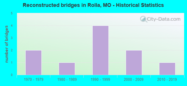
- Reconstructed bridges - Historical Statistics
- 21970-1979
- 11980-1989
- 41990-1999
- 22000-2009
- 12010-2019
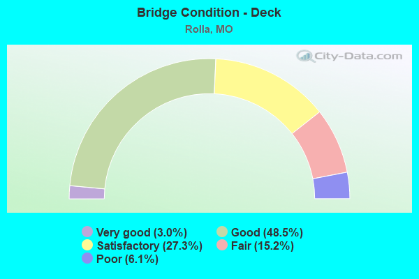
- Bridge Condition - Deck
- 3.0%Very good
- 48.5%Good
- 27.3%Satisfactory
- 15.2%Fair
- 6.1%Poor
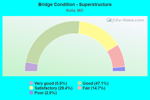
- Bridge Condition - Superstructure
- 5.9%Very good
- 47.1%Good
- 29.4%Satisfactory
- 14.7%Fair
- 2.9%Poor
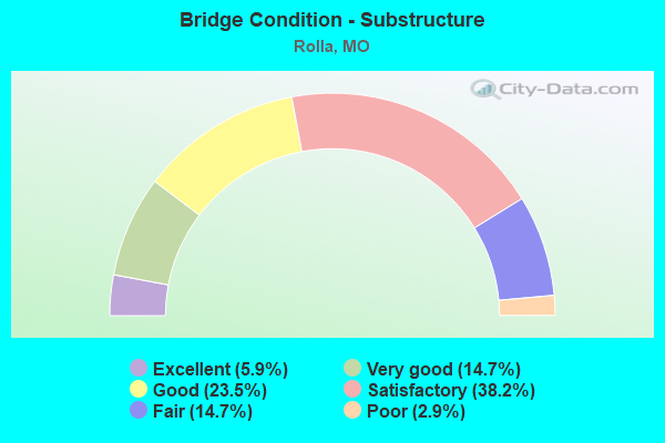
- Bridge Condition - Substructure
- 5.9%Excellent
- 14.7%Very good
- 23.5%Good
- 38.2%Satisfactory
- 14.7%Fair
- 2.9%Poor
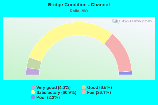
- Bridge Condition - Channel
- 4.3%Very good
- 6.5%Good
- 60.9%Satisfactory
- 26.1%Fair
- 2.2%Poor
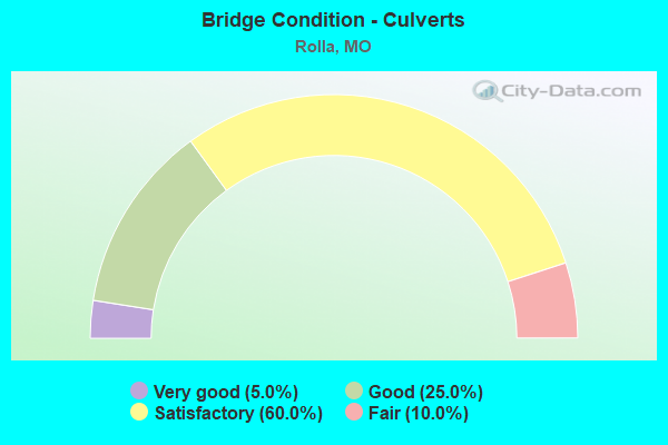
- Bridge Condition - Culverts
- 5.0%Very good
- 25.0%Good
- 60.0%Satisfactory
- 10.0%Fair
Find on map >> Show street view
Structure Number: 32558, Location: S 11 T 37 N R 8 W (Lat: 37.943056, Lng: -91.770528), Route carried "on" structure: City street 3775, Year Built: 2005, Status: Open, Structure Length: 0.66m (2.17ft), Average Daily Traffic: 200 (year 2020), Truck Traffic: 15%, Average Future Daily Traffic: 290 (year 2040), Design Load: HS 20, Features Intersected: CARTER CR, Facility Carried by Structure: ELM ST
Minimum Vertical Clearance: 30+ m (98+ ft), Kilometerpoint: 2.736, Lanes on structure: 2, Owner: City or Municipal Highway Agency, Approaching Roadway Width: 8.2m (26.9ft), Material/Design: Concrete continuous, Design/Construction: Culvert, Number Of Spans In Main Unit: 2, Length of Maximum Span: 3.0m (9.8ft), Curb-To-Curb Width: 8.2m (26.9ft), Out-to-Out Width: 8.2m (26.9ft)
Condition: Channel: Satisfactory, Culverts: Good, Inventory Rating: 99.0 metric tons, Method Used To Determine Inventory Rating: Load Factor (LF), Structural Evaluation: Better than present minimum criteria, Deck Geometry: Somewhat better than minimum adequacy, Waterway Adequacy: Better than present minimum criteria, Approach Roadway Alignment: Equal to present desirable criteria, Designated Inspection Frequency: Every 24 months, Inspection Date: November 2021, Deck Structure Type: Other, Wearing Surface/Protective System: Wearing Surface: Bituminous
Find on map >> Show street view
Structure Number: 3374, Location: S 1 T 37 N R 8 W (Lat: 37.951497, Lng: -91.753614), Route carried "on" structure: State highway BB, Year Built: 1982, Status: Open, Structure Length: 0.97m (3.18ft), Average Daily Traffic: 10,717 (year 2021), Truck Traffic: 5%, Average Future Daily Traffic: 17,147 (year 2041), Design Load: HS 20, Features Intersected: BURGHER BR
Minimum Vertical Clearance: 30+ m (98+ ft), Kilometerpoint: 2.063, Lanes on structure: 2, Owner: State Highway Agency, Approaching Roadway Width: 15.5m (50.9ft), Skew: 10 degrees, Material/Design: Concrete continuous, Design/Construction: Culvert, Number Of Spans In Main Unit: 3, Length of Maximum Span: 3.0m (9.8ft), Curb-To-Curb Width: 11.6m (38.1ft), Out-to-Out Width: 12.5m (41.0ft)
Condition: Channel: Satisfactory, Culverts: Fair, Inventory Rating: 91.8 metric tons, Method Used To Determine Inventory Rating: Load Factor (LF), Structural Evaluation: Somewhat better than minimum adequacy, Deck Geometry: Somewhat better than minimum adequacy, Waterway Adequacy: Equal to present desirable criteria, Approach Roadway Alignment: Equal to present desirable criteria, Designated Inspection Frequency: Every 24 months, Inspection Date: May 2021, Deck Structure Type: Concrete Cast-file-Place, Wearing Surface/Protective System: Wearing Surface: Bituminous, Deck Protection: Epoxy Coated Reinforcing
Find on map >> Show street view
Structure Number: 34669, Location: S 21 T 37 N R 8 W (Lat: 37.922500, Lng: -91.817250), Route carried "on" structure: County highway 276, Year Built: 1965, Status: Open, Structure Length: 0.68m (2.23ft), Average Daily Traffic: 25 (year 2020), Truck Traffic: 10%, Average Future Daily Traffic: 33 (year 2040), Features Intersected: CREEK, Facility Carried by Structure: COUNTY RD 7030
Minimum Vertical Clearance: 30+ m (98+ ft), Kilometerpoint: 0.451, Lanes on structure: 1, Owner: County Highway Agency, Approaching Roadway Width: 3.7m (12.1ft), Material/Design: Concrete, Design/Construction: Culvert, Number Of Spans In Main Unit: 3, Length of Maximum Span: 2.2m (7.2ft), Curb-To-Curb Width: 3.7m (12.1ft), Out-to-Out Width: 5.2m (17.1ft)
Condition: Channel: Satisfactory, Culverts: Fair, Operating Rating: 24.3 metric tons, Method Used To Determine Operating Rating: Field evaluation and documented engineering judgment, Inventory Rating: 14.4 metric tons, Method Used To Determine Inventory Rating: Field evaluation and documented engineering judgment, Structural Evaluation: Meets minimum limits, Deck Geometry: Meets minimum limits, Waterway Adequacy: Better than present minimum criteria, Approach Roadway Alignment: Equal to present desirable criteria, Designated Inspection Frequency: Every 24 months, Inspection Date: November 2021, Deck Structure Type: Concrete Cast-file-Place, Wearing Surface/Protective System: Wearing Surface: Bituminous
Find on map >> Show street view
Structure Number: 35695, Location: S 10 T 37 N R 8 W (Lat: 37.942222, Lng: -91.785417), Route carried "on" structure: City street 37, Year Built: 2018, Status: Open, Structure Length: 7.30m (23.95ft), Average Daily Traffic: 12,100 (year 2020), Truck Traffic: 12%, Average Future Daily Traffic: 17,545 (year 2040), Features Intersected: BNSF RR, Facility Carried by Structure: ROUTE 72
Minimum Vertical Clearance: 30+ m (98+ ft), Kilometerpoint: 3.380, Lanes on structure: 4, Owner: City or Municipal Highway Agency, Approaching Roadway Width: 15.9m (52.2ft), Skew: 1 degrees, Material/Design: Prestressed concrete continuous, Design/Construction: Stringer/Multi-beam, Number Of Spans In Main Unit: 3, Length of Maximum Span: 29.0m (95.1ft), Curb or Sidewalk Widths: Left: 2.0m (6.6ft), Right: 0.0m, Curb-To-Curb Width: 15.9m (52.2ft), Out-to-Out Width: 18.7m (61.4ft)
Condition: Deck: Good, Superstructure: Very good, Substructure: Excellent, Operating Rating: 52.2 metric tons, Method Used To Determine Operating Rating: Load Factor (LF), Inventory Rating: 31.5 metric tons, Method Used To Determine Inventory Rating: Load Factor (LF), Structural Evaluation: Better than present minimum criteria, Deck Geometry: Meets minimum limits, Underclear: Superior to present desirable criteria, Approach Roadway Alignment: Equal to present desirable criteria, Designated Inspection Frequency: Every 24 months, Inspection Date: November 2021, Deck Structure Type: Concrete Precast Panels, Wearing Surface/Protective System: Wearing Surface: Monolithic Concrete, Deck Protection: Epoxy Coated Reinforcing
Find on map >> Show street view
Structure Number: 3722, Location: S 1 T 37 N R 8 W (Lat: 37.961386, Lng: -91.765706), Route carried "on" structure: US 63, Year Built: 1987, Status: Open, Structure Length: 7.50m (24.61ft), Average Daily Traffic: 11,670 (year 2021), Truck Traffic: 22%, Average Future Daily Traffic: 18,672 (year 2041), Design Load: HS 20+Mod, Features Intersected: IS 44
Minimum Vertical Clearance: 30+ m (98+ ft), Kilometerpoint: 339.543, Lanes on structure: 4, Lanes under structure: 4, Base Highway Network: Yes, Owner: State Highway Agency, Approaching Roadway Width: 20.7m (67.9ft), Skew: 3 degrees, Material/Design: Steel continuous, Design/Construction: Stringer/Multi-beam, Number Of Spans In Main Unit: 3, Length of Maximum Span: 42.1m (138.1ft), Curb or Sidewalk Widths: Left: 1.4m (4.6ft), Right: 0.2m (0.7ft), Curb-To-Curb Width: 20.4m (66.9ft), Out-to-Out Width: 21.2m (69.6ft)
Condition: Deck: Satisfactory, Superstructure: Good, Substructure: Good, Operating Rating: 71.1 metric tons, Method Used To Determine Operating Rating: Load Factor (LF), Inventory Rating: 42.3 metric tons, Method Used To Determine Inventory Rating: Load Factor (LF), Structural Evaluation: Better than present minimum criteria, Deck Geometry: Superior to present desirable criteria, Underclear: Better than present minimum criteria, Approach Roadway Alignment: Equal to present minimum criteria, Designated Inspection Frequency: Every 24 months, Inspection Date: May 2021, Deck Structure Type: Concrete Cast-file-Place, Wearing Surface/Protective System: Wearing Surface: Bituminous, Deck Protection: Epoxy Coated Reinforcing
Find on map >> Show street view
Structure Number: 5603, Location: S 11 T 37 N R 8 W (Lat: 37.942417, Lng: -91.770144), Route carried "on" structure: State highway 72, Year Built: 1931, Year Reconstructed: 1997, Status: Open, Structure Length: 1.08m (3.54ft), Average Daily Traffic: 12,934 (year 2021), Truck Traffic: 7%, Average Future Daily Traffic: 20,694 (year 2041), Design Load: HS 20, Features Intersected: LOVE BR
Minimum Vertical Clearance: 30+ m (98+ ft), Kilometerpoint: 1.622, Lanes on structure: 5, Owner: State Highway Agency, Approaching Roadway Width: 24.4m (80.1ft), Skew: 2 degrees, Material/Design: Concrete continuous, Design/Construction: Culvert, Number Of Spans In Main Unit: 3, Length of Maximum Span: 3.0m (9.8ft)
Condition: Channel: Satisfactory, Culverts: Good, Operating Rating: 61.2 metric tons, Method Used To Determine Operating Rating: Load Factor (LF), Inventory Rating: 36.9 metric tons, Method Used To Determine Inventory Rating: Load Factor (LF), Structural Evaluation: Better than present minimum criteria, Waterway Adequacy: Equal to present minimum criteria, Approach Roadway Alignment: Equal to present desirable criteria, Designated Inspection Frequency: Every 24 months, Inspection Date: May 2021
Find on map >> Show street view
Structure Number: 7206, Location: S 21 T 38 N R 8 W (Lat: 38.002364, Lng: -91.807378), Route carried "on" structure: State highway HH, Year Built: 1958, Status: Open, Structure Length: 1.25m (4.10ft), Average Daily Traffic: 466 (year 2021), Truck Traffic: 2%, Average Future Daily Traffic: 699 (year 2041), Design Load: H 10, Features Intersected: WILDCAT BR
Minimum Vertical Clearance: 30+ m (98+ ft), Kilometerpoint: 3.024, Lanes on structure: 2, Owner: State Highway Agency, Approaching Roadway Width: 6.7m (22.0ft), Skew: 2 degrees, Material/Design: Concrete continuous, Design/Construction: Culvert, Number Of Spans In Main Unit: 3, Length of Maximum Span: 3.7m (12.1ft), Curb-To-Curb Width: 7.3m (24.0ft), Out-to-Out Width: 7.9m (25.9ft)
Condition: Channel: Fair, Culverts: Satisfactory, Operating Rating: 38.7 metric tons, Method Used To Determine Operating Rating: Load Factor (LF), Inventory Rating: 23.4 metric tons, Method Used To Determine Inventory Rating: Load Factor (LF), Structural Evaluation: Equal to present minimum criteria, Deck Geometry: Meets minimum limits, Waterway Adequacy: Better than present minimum criteria, Approach Roadway Alignment: Equal to present minimum criteria, Designated Inspection Frequency: Every 24 months, Inspection Date: May 2021
Find on map >> Show street view
Structure Number: 7775, Location: S 5 T 37 N R 7 W (Lat: 37.951086, Lng: -91.718556), Route carried "on" structure: State highway BB, Year Built: 1954, Status: Open, Structure Length: 0.74m (2.43ft), Average Daily Traffic: 4,571 (year 2021), Truck Traffic: 4%, Average Future Daily Traffic: 6,857 (year 2041), Design Load: H 10, Features Intersected: FRANZ BR
Minimum Vertical Clearance: 30+ m (98+ ft), Kilometerpoint: 5.142, Lanes on structure: 2, Owner: State Highway Agency, Approaching Roadway Width: 6.1m (20.0ft), Skew: 4 degrees, Material/Design: Concrete continuous, Design/Construction: Culvert, Number Of Spans In Main Unit: 2, Length of Maximum Span: 2.7m (8.9ft), Curb-To-Curb Width: 7.3m (24.0ft), Out-to-Out Width: 7.9m (25.9ft)
Condition: Channel: Very good, Culverts: Satisfactory, Operating Rating: 45.9 metric tons, Method Used To Determine Operating Rating: Load Factor (LF), Inventory Rating: 27.0 metric tons, Method Used To Determine Inventory Rating: Load Factor (LF), Structural Evaluation: Equal to present minimum criteria, Deck Geometry: High priority of replacement, Waterway Adequacy: Equal to present minimum criteria, Approach Roadway Alignment: Equal to present minimum criteria, Length Of Structure Improvement: 0.14m (0.46ft), Designated Inspection Frequency: Every 24 months, Inspection Date: May 2021, Bridge Improvement Cost: $170,000, Roadway Improvement Cost: $17,000, Total Project Cost: $255,000 ( Estimate for 2022)
Find on map >> Show street view
Structure Number: 7842, Location: S 4 T 37 N R 7 W (Lat: 37.950992, Lng: -91.688975), Route carried "on" structure: State highway BB, Year Built: 1954, Status: Open, Structure Length: 1.15m (3.77ft), Average Daily Traffic: 3,757 (year 2021), Truck Traffic: 11%, Average Future Daily Traffic: 5,636 (year 2041), Design Load: H 10, Features Intersected: DAILEY BR
Minimum Vertical Clearance: 30+ m (98+ ft), Kilometerpoint: 7.744, Lanes on structure: 2, Owner: State Highway Agency, Approaching Roadway Width: 6.7m (22.0ft), Material/Design: Concrete continuous, Design/Construction: Culvert, Number Of Spans In Main Unit: 3, Length of Maximum Span: 3.7m (12.1ft)
Condition: Channel: Very good, Culverts: Satisfactory, Operating Rating: 46.8 metric tons, Method Used To Determine Operating Rating: Load Factor (LF), Inventory Rating: 27.9 metric tons, Method Used To Determine Inventory Rating: Load Factor (LF), Structural Evaluation: Equal to present minimum criteria, Waterway Adequacy: Equal to present desirable criteria, Approach Roadway Alignment: Equal to present minimum criteria, Designated Inspection Frequency: Every 24 months, Inspection Date: May 2021
Find on map >> Show street view
Structure Number: 8354, Location: S 9 T 37 N R 8 W (Lat: 37.940186, Lng: -91.814231), Route carried "on" structure: ServiceState highway 44, Year Built: 1964, Status: Open, Structure Length: 1.06m (3.48ft), Average Daily Traffic: 3,641 (year 2021), Truck Traffic: 13%, Average Future Daily Traffic: 5,462 (year 2041), Design Load: H 15, Features Intersected: FK LIT BEAVER CR
Minimum Vertical Clearance: 30+ m (98+ ft), Kilometerpoint: 1.701, Lanes on structure: 2, Owner: State Highway Agency, Approaching Roadway Width: 7.3m (24.0ft), Skew: 4 degrees, Material/Design: Concrete continuous, Design/Construction: Culvert, Number Of Spans In Main Unit: 2, Length of Maximum Span: 3.7m (12.1ft)
Condition: Channel: Satisfactory, Culverts: Satisfactory, Operating Rating: 97.2 metric tons, Method Used To Determine Operating Rating: Load Factor (LF), Inventory Rating: 58.5 metric tons, Method Used To Determine Inventory Rating: Load Factor (LF), Structural Evaluation: Equal to present minimum criteria, Waterway Adequacy: Better than present minimum criteria, Approach Roadway Alignment: Equal to present desirable criteria, Designated Inspection Frequency: Every 24 months, Inspection Date: May 2021
Find on map >> Show street view
Structure Number: 9782, Location: S 13 T 37 N R 8 W (Lat: 37.929811, Lng: -91.748156), Route carried "on" structure: State highway O, Year Built: 1948, Year Reconstructed: 2006, Status: Open, Structure Length: 1.21m (3.97ft), Average Daily Traffic: 4,839 (year 2021), Truck Traffic: 7%, Average Future Daily Traffic: 7,742 (year 2041), Design Load: H 10, Features Intersected: LOVE BR
Minimum Vertical Clearance: 30+ m (98+ ft), Kilometerpoint: 0.607, Lanes on structure: 2, Owner: State Highway Agency, Approaching Roadway Width: 7.3m (24.0ft), Material/Design: Concrete continuous, Design/Construction: Culvert, Number Of Spans In Main Unit: 2, Number Of Approach Spans: 1, Length of Maximum Span: 3.7m (12.1ft)
Condition: Channel: Fair, Culverts: Satisfactory, Operating Rating: 43.2 metric tons, Method Used To Determine Operating Rating: Load Factor (LF), Inventory Rating: 26.1 metric tons, Method Used To Determine Inventory Rating: Load Factor (LF), Structural Evaluation: Equal to present minimum criteria, Waterway Adequacy: Equal to present minimum criteria, Approach Roadway Alignment: Equal to present desirable criteria, Designated Inspection Frequency: Every 24 months, Inspection Date: May 2021
Find on map >> Show street view
Structure Number: 9783, Location: S 13 T 37 N R 8 W (Lat: 37.929367, Lng: -91.748167), Route carried "on" structure: State highway O, Year Built: 1948, Year Reconstructed: 2006, Status: Open, Structure Length: 1.25m (4.10ft), Average Daily Traffic: 4,839 (year 2021), Truck Traffic: 7%, Average Future Daily Traffic: 7,742 (year 2041), Design Load: H 10, Features Intersected: DEIBLE BR
Minimum Vertical Clearance: 30+ m (98+ ft), Kilometerpoint: 0.657, Lanes on structure: 2, Owner: State Highway Agency, Approaching Roadway Width: 7.3m (24.0ft), Skew: 4 degrees, Material/Design: Concrete continuous, Design/Construction: Culvert, Number Of Spans In Main Unit: 2, Number Of Approach Spans: 1, Length of Maximum Span: 3.0m (9.8ft)
Condition: Channel: Good, Culverts: Satisfactory, Operating Rating: 41.4 metric tons, Method Used To Determine Operating Rating: Load Factor (LF), Inventory Rating: 25.2 metric tons, Method Used To Determine Inventory Rating: Load Factor (LF), Structural Evaluation: Equal to present minimum criteria, Waterway Adequacy: Equal to present minimum criteria, Approach Roadway Alignment: Equal to present desirable criteria, Designated Inspection Frequency: Every 24 months, Inspection Date: May 2021
Find on map >> Show street view
Structure Number: 1039, Location: S 10 T 37 N R 8 W (Lat: 37.943892, Lng: -91.792350), Route carried "under" structure: Interstate 44, Year Built: 1964, Structure Length: 0. m, Average Daily Traffic: 16,202 (year 2021), Truck Traffic: 29%, Features Intersected: IS 44
Minimum Vertical Clearance: 5.05m (16.57ft), Kilometerpoint: 297.053, Lanes on structure: 2, Lanes under structure: 2, Material/Design: Concrete continuous, Design/Construction: Slab, Length of Maximum Span: 19.5m (64.0ft)
Find on map >> Show street view
Structure Number: 1039, Location: S 10 T 37 N R 8 W (Lat: 37.943892, Lng: -91.792350), Route carried "under" structure: Interstate 44, Year Built: 1964, Structure Length: 0. m, Average Daily Traffic: 13,586 (year 2021), Truck Traffic: 37%, Features Intersected: IS 44
Minimum Vertical Clearance: 4.88m (16.01ft), Kilometerpoint: 174.724, Lanes on structure: 2, Lanes under structure: 2, Material/Design: Concrete continuous, Design/Construction: Slab, Length of Maximum Span: 19.5m (64.0ft)
Find on map >> Show street view
Structure Number: 1041, Location: S 2 T 37 N R 8 W (Lat: 37.956186, Lng: -91.782000), Route carried "under" structure: Interstate 44, Year Built: 1964, Structure Length: 0. m, Average Daily Traffic: 13,586 (year 2021), Truck Traffic: 37%, Features Intersected: IS 44, Facility Carried by Structure: RT E S
Minimum Vertical Clearance: 4.95m (16.24ft), Kilometerpoint: 298.778, Lanes on structure: 2, Lanes under structure: 2, Material/Design: Concrete continuous, Design/Construction: Slab, Length of Maximum Span: 20.4m (66.9ft)
Find on map >> Show street view
Structure Number: 1041, Location: S 2 T 37 N R 8 W (Lat: 37.956186, Lng: -91.782000), Route carried "under" structure: Interstate 44, Year Built: 1964, Structure Length: 0. m, Average Daily Traffic: 13,020 (year 2021), Truck Traffic: 29%, Features Intersected: IS 44, Facility Carried by Structure: RT E S
Minimum Vertical Clearance: 5.23m (17.16ft), Kilometerpoint: 172.998, Lanes on structure: 2, Lanes under structure: 2, Material/Design: Concrete continuous, Design/Construction: Slab, Length of Maximum Span: 20.4m (66.9ft)
Find on map >> Show street view
Structure Number: 1072, Location: S 32 T 38 N R 7 W (Lat: 37.979417, Lng: -91.719350), Route carried "under" structure: Interstate 44, Year Built: 1964, Structure Length: 0. m, Average Daily Traffic: 14,864 (year 2021), Truck Traffic: 33%, Features Intersected: IS 44, Facility Carried by Structure: RT V E
Minimum Vertical Clearance: 5.31m (17.42ft), Kilometerpoint: 305.367, Lanes on structure: 3, Lanes under structure: 2, Material/Design: Concrete continuous, Design/Construction: Slab, Length of Maximum Span: 17.4m (57.1ft)
Find on map >> Show street view
Structure Number: 1072, Location: S 32 T 38 N R 7 W (Lat: 37.979417, Lng: -91.719350), Route carried "under" structure: Interstate 44, Year Built: 1964, Structure Length: 0. m, Average Daily Traffic: 16,468 (year 2021), Truck Traffic: 35%, Features Intersected: IS 44, Facility Carried by Structure: RT V E
Minimum Vertical Clearance: 5.13m (16.83ft), Kilometerpoint: 166.398, Lanes on structure: 3, Lanes under structure: 2, Material/Design: Concrete continuous, Design/Construction: Slab, Length of Maximum Span: 17.4m (57.1ft)
Find on map >> Show street view
Structure Number: 2646, Location: S 11 T 37 N R 8 W (Lat: 37.951456, Lng: -91.769050), Route carried "under" structure: City street , Year Built: 1974, Structure Length: 0. m, Average Daily Traffic: 3,500 (year 2021), Truck Traffic: 5%, Features Intersected: CST OAK ST, Facility Carried by Structure: RT BB E
Minimum Vertical Clearance: 5.03m (16.50ft), Kilometerpoint: 0.982, Lanes on structure: 3, Lanes under structure: 2, Material/Design: Steel continuous, Design/Construction: Stringer/Multi-beam, Length of Maximum Span: 18.6m (61.0ft)
Find on map >> Show street view
Structure Number: 2646, Location: S 11 T 37 N R 8 W (Lat: 37.951456, Lng: -91.769050), Route carried "under" structure: City street , Year Built: 1974, Structure Length: 0. m, Average Daily Traffic: 2,630 (year 2021), Truck Traffic: 5%, Features Intersected: CST OLIVE, Facility Carried by Structure: RT BB E
Minimum Vertical Clearance: 5.03m (16.50ft), Kilometerpoint: 0.214, Lanes on structure: 3, Lanes under structure: 2, Material/Design: Steel continuous, Design/Construction: Stringer/Multi-beam, Length of Maximum Span: 18.6m (61.0ft)
Find on map >> Show street view
Structure Number: 31127, Location: S 2 T 37 N R 8 W (Lat: 37.960542, Lng: -91.773244), Route carried "under" structure: Interstate 44, Year Built: 2005, Structure Length: 0. m, Average Daily Traffic: 11,213 (year 2021), Truck Traffic: 29%, Features Intersected: IS 44, Facility Carried by Structure: VICHY RD S
Minimum Vertical Clearance: 5.20m (17.06ft), Kilometerpoint: 299.697, Lanes on structure: 2, Lanes under structure: 3, Material/Design: Steel continuous, Design/Construction: Stringer/Multi-beam, Length of Maximum Span: 37.8m (124.0ft)
Find on map >> Show street view
Structure Number: 31127, Location: S 2 T 37 N R 8 W (Lat: 37.960542, Lng: -91.773244), Route carried "under" structure: Interstate 44, Year Built: 2005, Structure Length: 0. m, Average Daily Traffic: 13,020 (year 2021), Truck Traffic: 29%, Features Intersected: IS 44, Facility Carried by Structure: VICHY RD S
Minimum Vertical Clearance: 5.44m (17.85ft), Kilometerpoint: 172.063, Lanes on structure: 2, Lanes under structure: 3, Material/Design: Steel continuous, Design/Construction: Stringer/Multi-beam, Length of Maximum Span: 37.8m (124.0ft)
Find on map >> Show street view
Structure Number: 3722, Location: S 1 T 37 N R 8 W (Lat: 37.961386, Lng: -91.765706), Route carried "under" structure: Interstate 44, Year Built: 1987, Structure Length: 0. m, Average Daily Traffic: 11,213 (year 2021), Truck Traffic: 29%, Features Intersected: IS 44, Facility Carried by Structure: US 63 S
Minimum Vertical Clearance: 5.13m (16.83ft), Kilometerpoint: 300.375, Lanes on structure: 4, Lanes under structure: 2, Material/Design: Steel continuous, Design/Construction: Stringer/Multi-beam, Length of Maximum Span: 42.1m (138.1ft)
Find on map >> Show street view
Structure Number: 3722, Location: S 1 T 37 N R 8 W (Lat: 37.961386, Lng: -91.765706), Route carried "under" structure: Interstate 44, Year Built: 1987, Structure Length: 0. m, Average Daily Traffic: 15,147 (year 2021), Truck Traffic: 33%, Features Intersected: IS 44, Facility Carried by Structure: US 63 S
Minimum Vertical Clearance: 5.77m (18.93ft), Kilometerpoint: 171.386, Lanes on structure: 4, Lanes under structure: 2, Material/Design: Steel continuous, Design/Construction: Stringer/Multi-beam, Length of Maximum Span: 42.1m (138.1ft)